Article

Multivariate Analysis of the Community Composition of Tidal Freshwater Forests on the Altamaha River, Georgia

by
Galen Costomiris
1,
Christine M. Hladik
2,* and
Christopher Craft
3
1
School of Geosciences, University of Edinburgh, Edinburgh EH9 3FF, UK
2
School of Earth, Environment, and Sustainability Geosciences Program, Georgia Southern University, Statesboro, GA 30460, USA
3
O’Neill School of Public and Environmental Affairs, Indiana University, Bloomington, IN 47405, USA
*
Author to whom correspondence should be addressed.
Forests 2024, 15(1), 200; https://doi.org/10.3390/f15010200
Submission received: 7 December 2023 / Revised: 3 January 2024 / Accepted: 9 January 2024 / Published: 19 January 2024
(This article belongs to the Special Issue Coastal Forest Dynamics and Coastline Erosion—Series II)

Abstract

:
Situated in the transitional zone between non-tidal forests upstream and tidal freshwater marshes downstream, tidal freshwater forests (TFF) occupy a unique and increasingly precarious habitat due to the threat of saltwater intrusion and sea level rise. Salinization causes tree mortality and forest-to-marsh transition, which reduces biodiversity and carbon sequestration. The Altamaha River is the longest undammed river on the United States East Coast and has extensive TFF, but there have been only limited field studies examining TFF along the entire gradient of salinity and flooding. We surveyed thirty-eight forest plots on the Altamaha River along a gradient of tidal influence, and measured tree species composition, diameter, and height. Hierarchical clustering and indicator species analysis were used to identify TFF communities. The relationship of these communities to elevation and river distance was assessed using non-metric multidimensional scaling (NMDS). We identified six significantly different forest communities: Oak/Hornbeam, Water Tupelo, Bald Cypress/Tupelo, Pine, Swamp Tupelo, and Bald Cypress. Both elevation and river distance were significantly correlated with plot species composition (p = 0.001). Plots at the downstream extent of our study area had lower stem density, basal area, and species diversity than those further upstream, suggesting saltwater intrusion. This study demonstrates the importance of and need for thorough and robust analyses of tidal freshwater forest composition to improve prediction of TFF response to sea level rise.

1. Introduction

Tidal freshwater forests (TFF) are freshwater riparian ecosystems located between the upstream extent of tidal flooding and tidal fresh marshes downstream. They are flooded daily by fresh river water displaced at high tide due to tidal forcing [1]. Salinity is moderated by freshwater river discharge and under most conditions remains below 0.5 practical salinity units (PSU) (seawater is ~35 PSU) [1]. Due to their low elevation, tidal influence, and limited tolerance for salinity, these species-rich ecosystems are threatened by climate change, especially saltwater intrusion [2]. Prior studies have documented rapid rates of forest-to-marsh transition in TFF affected by sea level rise [3,4,5,6], but even intermittent pulses of salinity from tropical storms can have adverse effects on forest health [7].
The importance of TFF ecosystems is widely recognized [2,8,9,10], but TFF remain understudied compared to salt marshes or non-tidal riparian ecosystems [1,2,7,11,12,13]. Doyle et al. [1] suggest that TFF are understudied because they have been altered or destroyed by human activities such as logging and drainage prior to scientific study, and continued management for flood control, navigability, and wildlife habitat have prevented large areas of TFF from regenerating. Remaining TFF provide many valuable ecosystem services, from nutrient removal through water filtration to flood protection and buffering coastal areas against the impact of tropical storms [11,14]. TFF can also be more effective at sequestering carbon than upland forests due to higher rates of sediment C burial [15]. TFF on the Altamaha sequester 22 to 75 g C m−2 yr−1 [11], a rate comparable to some highly productive temperate upland forests that sequester 21 to 55 g C m−2 yr−1 [15]. TFF are also highly biodiverse, providing habitat to many protected species [16].
While the tidal marsh vegetation of the Altamaha is well studied [17,18,19], its TFF are less well documented. Prior studies have examined Altamaha TFF community composition [12,20], soil properties [11], and aboveground productivity [20]; however, these studies were limited in spatial extent and confined to upstream areas. No prior studies have sampled TFF on the Altamaha River across the full range of tidal influence, from brackish tidal marsh–TFF mixtures to freshwater riparian areas. Existing models of forest–marsh transition [4,21], including those applied to the Altamaha [22,23], assume that TFF are homogeneous. In fact, TFF are quite diverse, and their constituent species have substantially different tolerances for inundation and salinity. A detailed understanding of TFF species distributions is essential to accurately modeling and monitoring how TFF respond to sea level rise. In particular, remote sensing-based classifications and estimations of biomass and carbon storage capacity rely on comprehensive ground reference datasets which did not previously exist for the Altamaha River TFF.
We identified six significantly different forest communities: Oak/Hornbeam, Water Tupelo, Bald Cypress/Tupelo, Pine, Swamp Tupelo, and Bald Cypress. These communities align well with prior studies of TFF in Georgia, except for greater bald cypress (Taxodium distichum [L.] Rich.) abundance [9,12]. Both elevation and river distance were significantly correlated with plot species composition (p-value = 0.001). Plots at the downstream extent of our study area had lower stem density, basal area, and species diversity than those further upstream, characteristics which are linked to saltwater intrusion [24,25].

2. Materials and Methods

2.1. Study Site

Our study site is located on the central Georgia coast, near the mouth of the Altamaha River (31°20′28.66″ N, 81°26′53.32″ W). The Altamaha River is the longest undammed river in the eastern U.S. and the largest in the state of Georgia, draining 3.6 million hectares, 23% of the state [16]. The Oconee and Ocmulgee Rivers, the main tributaries of the Altamaha, originate in the foothills of the Appalachian Mountains [18]. From the confluence of these two rivers, the main stem of the Altamaha runs 220 km through the coastal plain to its mouth on the Georgia Bight [18]. The Altamaha estuary has a semi-diurnal tide cycle with an amplitude of approximately 2 m [26]. The head of tide is 54 km from the river mouth, but the large volume of freshwater discharge (393 m3 s−1 on average) typically prevents salinity from reaching further than 20 km upstream [18,27].
Unlike many other river systems which have been dammed or channelized for agricultural or commercial purposes [28], the relatively intact nature of the Altamaha TFF makes it an ideal site to study the effects of sea level rise and increased salinity. Although the lower Altamaha River has been subjected to the anthropogenic modifications typical of these areas (logging, drainage, diking, and rice farming) [8,29], today, much of the Altamaha River’s TFF is located within United States Fish and Wildlife Service Wildlife Management Areas (WMAs) and the domain of the Georgia Coastal Ecosystems Long-Term Ecological Research (GCE LTER) site [30].
The soils of TFF vary with elevation, hydrology, and vegetation cover, but are less well characterized than upland soils [31]. The most common soil type in our study area is described only as “swamp”, a type of fluvaquent, which covers 35% of our study area [32]. In general, TFF soils are anaerobic and high in organic matter (up to 15.5% carbon) [11,31]. Inorganic soil components are mainly sand and silt [11]. Fulton Ridge, which extends into the northern part of our study area, is formed from the remnants of Pleistocene-era aeolian dunes [29]. Its soils are infrequently flooded sands, sandy loams, and clay loams [32].
Our study site contains a variety of ecosystems, ranging from scrub oak sandhill communities to tidally flooded mesohaline marsh (Figure 1). Brackish and tidal fresh marsh vegetation are primarily giant cutgrass (Zizaniopsis miliacea Michx.), black needlerush (Juncus roemerianus Scheele), and big cordgrass (Spartina cynosuroides [L.] Roth) [18]. This project focuses on the TFF ecosystem, which in Georgia is dominated by water tupelo (N. aquatica L.), swamp tupelo (N. biflora Walt.), and bald cypress, interspersed with sweetgum (Liquidambar styraciflua L.), red maple (Acer rubrum L.), and water oak (Quercus nigra L.) [9,11,12].
The entire Altamaha River study area was logged at one time in its history, and active forest management continues in upland areas [18,29]. Selective logging of bald cypress for its rot-resistant wood has changed the makeup of the tidal forests and may have increased the abundance of water tupelo, which occupies a similar elevation range [29]. Large areas on the lower Altamaha River were developed for rice cultivation between the late 17th and mid-19th centuries [33]. Some of these fields are still under cultivation, while others have been abandoned, reverting to a mixture of marsh and forest vegetation. However, the drainage ditches constructed to enable logging and rice cultivation remain and increase hydrologic connectivity, elevating the risk of saltwater intrusion and nutrient leaching [34]. At the same time, dikes around disused rice fields reduce drainage, which can concentrate and increase salinity [35].

2.2. Field Sampling

We sampled vegetation at thirty-eight 500 m2 circular plots between 15 May and 12 June 2021 (Figure 1). Plots were distributed using a stratified random technique based on a preliminary supervised classification of Sentinel-2 Multispectral Instrument (MSI) satellite imagery with five major forest classes: tupelo, pine, bald cypress, bald cypress/tupelo, and salt-stressed transitional forest. We navigated to each plot using a Garmin eTrex 30 GPS (Garmin International Inc., Olathe, KS, USA), which was used to record plot location. At each plot center, we recorded a general site description, took photographs, and measured canopy coverage using a canopy densiometer (Forest Densiometers, Marianna, FL, USA). Following the methodology of Anderson et al. [7], for all trees greater than 2.5 cm in diameter at breast height (DBH), we measured height using a laser hypsometer (Nikon Inc., Melville, NY, USA) and DBH with a diameter tape, identified them by species where possible, and assessed whether their crown reached the canopy.

2.3. Forest Community Analysis Overview

Distinct TFF communities were identified and described using a variety of multivariate statistical analyses implemented in R version 4.1.0 [36]. Initial grouping was performed via hierarchical clustering based on relative species abundance. Following clustering, specific plant communities were identified and described based on indicator species analysis. Multi-response permutation procedures (MRPP) were used to test the significance of differences between these communities as an external validation of our clustering methodology. Finally, sample plot groupings were visualized in relation to environmental variables (elevation and longitudinal river position) using nonmetric multidimensional scaling ordination (NMDS). Kruskal–Wallis and Dunn’s post-hoc tests were performed to test for differences in elevation and longitude between communities. All tests were considered significant at a p-value ≤ 0.05. All methods are described in detail below.

2.3.1. Plot-Level Vegetation Composition

Plot-level species diversity and abundance were initially described by computing species importance values (IV) following the method used by Duberstein et al. [12]. IV ranged from 0 to 1 and was calculated as:
[ ( R e l a t i v e   D e n s i t y + R e l a t i v e   D o m i n a n c e ) / 2 ]
where relative density is the sum of species density (trees/ha) divided by the sum of total density, and relative dominance is the sum of species basal area (m2/ha) divided by the sum of total basal area. IV provides a good summary of the relative influence of each species on the overall composition of a plot [37].
Prior to hierarchical clustering, raw plot data were summarized by calculating the total basal area for each species per plot. Due to difficulty distinguishing between species in the field, all ash trees (F. profunda [Bush] Bush, F. caroliniana Mill, and F. pennsylvanica Marsh) were combined at the genus level [12]. Likewise, laurel oak (Quercus laurifolia Michx.) and water oak (Quercus nigra L.) were grouped into a single class, as they are commonly found together and are capable of hybridizing [38]. Tree species that occurred in fewer than 5% (two plots or fewer) of plots were excluded [39]. Based on these criteria, 11 species were eliminated. Relative abundance data for the remaining species were standardized using a Hellinger transformation, which takes the square root of the row-standardized abundances [40]. This transformation reduces the influence of rare species and is not susceptible to the double-zero problem, in which a species’ absence from two sites erroneously increases their similarity [41]. Outlier analysis was performed using the distconnected function from the vegan R package (version 2.6-4) [42]. With a threshold dissimilarity of 0.9, two plots (331 and 350) were identified as outliers and removed from subsequent analyses. After exclusion of outlier plots, several more species fell below the 5% threshold and were removed from the analyses.

2.3.2. Community Analysis

A Hellinger distance matrix was calculated for the transformed plot data using the vegdist function in the vegan package [42]. Using these distances, hierarchical clustering was performed using the eclust function in the package factoextra (version 1.0.7) [43]. Ward’s minimum variance linkage was used, which groups clusters based on minimizing their analysis of variance (ANOVA) sum of squares [44]. Following clustering, the resulting dendrogram was pruned at a range of pruning levels from 2–10. Following Dufrêne and Legendre [45], these cluster identities were used as categorical variables, and indicator species analysis was implemented independently for each clustering level with the multipatt function from the package indicspecies [46]. This function calculates the indicator value index (IVI) for each species, which measures the strength of association between a species and each cluster or combination of clusters [45]. The maximum IVI for each species in any group was taken as its value for all groups [45]. Significance was assessed by comparing actual values to randomized data produced by a Monte Carlo simulation with 1000 iterations. Total p-values for all species and the number of significant indicator species (p < 0.05) were recorded for all clustering levels. Following Dufrene and Legendre [45], we plotted the number of significant indicator species and the total p-value for all species at each clustering level from 2 to 10 groups. Clustering levels with low total p-values and a high number of indicator species represent optimal pruning levels [39].
MRPP functions as a nonparametric alternative to ANOVA and tests for significant differences in species composition between plot groupings [39]. The test was implemented using the function mrpp from the vegan package [42]. MRPP first calculates the mean within-group distance (δ) for each cluster, weighted by the number of plots in each cluster. δ is then calculated for every possible partition of plots into clusters of the same size. The proportion of partitions for which the expected δ is less than the observed δ is calculated; this gives the p-value for the test. In addition to the overall probability, MRPP calculates within-group agreement (A), a measure of group homogeneity equal to 1 δ / E ( δ ) , where E(δ) is the expected mean within-group distance if species were grouped randomly. A will equal zero if there is no difference from a random distribution and one if all plots in a cluster have an identical species composition.
NMDS was performed with the metaMDS function from the vegan package [42] to determine the strength of the relationship between plot species composition and environmental variables. The function envfit (vegan package) was used to test the correlation between NMDS axes and two external environmental variables: longitude (which serves as a proxy for river distance) and elevation. Other studies have found these variables to have a significant relationship with TFF species distribution and community composition [7,47,48,49]. Mean elevation in meters for each plot relative to the North American Vertical Datum of 1988 (NAVD88) was calculated from a LiDAR-derived digital elevation model (DEM) of the study area with a horizontal spatial resolution of 2 m. The DEM was not corrected for vegetation bias [50]. Longitude was based on the plot center coordinates recorded in the field with GPS (Garmin eTrex 30, horizontal accuracy 3.65 m) and serves as a proxy for river distance. Ordination results were plotted in two dimensions, and environmental variables were visualized as surfaces using the function ordisurf (vegan package). Differences in elevation and longitude between groups were assessed using Kruskal–Wallis rank sum tests and Dunn’s test for multiple comparisons [51].

3. Results

3.1. Plot-Level Species Composition

Plot-level species composition varied considerably across our 37 plots. No single species occurred in every plot (Figure 2). Ash was the most widely distributed, occurring in 31 plots, followed by bald cypress (30 plots) and swamp tupelo (29 plots) (Figure 2). Pine was the least widely distributed of the eight most dominant species shown, occurring in just 4 plots. In 3 of those plots, however, it represented the majority of that plot’s IV (Figure 2). Dominant species (the species with the highest IV in each plot) were also variable (Figure 2). Bald cypress was the most common dominant species (11 plots), followed by swamp tupelo (9 plots), water tupelo (7 plots), and laurel oak/water oak (5 plots) (Figure 2).

3.2. Clustering Results

Hierarchical clustering produced a dendrogram with an agglomerative coefficient of 0.86 (scale of 0–1), with higher values indicating stronger, more compact clustering (Figure 3). Based on the relationship between p-values and the number of indicator species, either 7 or 10 clusters are optimal (Figure 4). We chose to prune at 6 clusters, as this gave the most reasonable ecological interpretation. Pruning at higher levels (7 to 10 groups) produced several clusters with only two constituent plots, challenging interpretation, while pruning at lower levels (<6 groups) obscured substantial differences between communities. Subsequent MRPP and NMDS analyses provided additional support for this decision.
The dendrogram revealed clear ecological stratification based on species composition (Figure 3). The two highest-level clusters separated continuously or frequently flooded plots from seasonally flooded or upland plots. The former was occupied primarily by flood-tolerant species such as tupelo and bald cypress, while the latter had varying compositions of oak (Quercus spp.) and pine (Pinus spp.). Within these two broad categories, many species were widely distributed (Table 1), so subsequent groupings are dependent on relative abundance rather than presence–absence. Hereafter, communities are referred to by the common name of the most dominant species to avoid confusion with plot-level species observations (Table 1).
MRPP results indicated that these six communities have significantly different species compositions, A = 0.434, p = 0.001, meaning that more than 40% of the variation in species composition could be explained by cluster identity.
NMDS ordination showed clear separation between groups of plots and strong environmental gradients (Figure 5). A two-dimensional solution was chosen as it provided an acceptably low stress score of 0.137 and optimal ecological interpretation [52]. Both longitude and elevation were strongly correlated with both axes (Figure 5).
Elevation was significantly different between our six communities (Kruskal–Wallis χ2 = 19.928, p = 0.001, df = 5). Longitude was also significantly different (K-W χ2 = 23.114, p < 0.001, df = 5). Dunn’s test for multiple comparisons indicated that the only significant differences in elevation were between the Bald Cypress and Water Oak/Hornbeam Communities (p = 0.026) and Swamp Tupelo and Water Oak/Hornbeam Communities (p = 0.027) (Figure 6A). Differences in longitude were only significant for Bald Cypress and Water Oak/Hornbeam (p = 0.001) and Swamp Tupelo and Water Oak/Hornbeam Communities (p = 0.008) (Figure 6B).

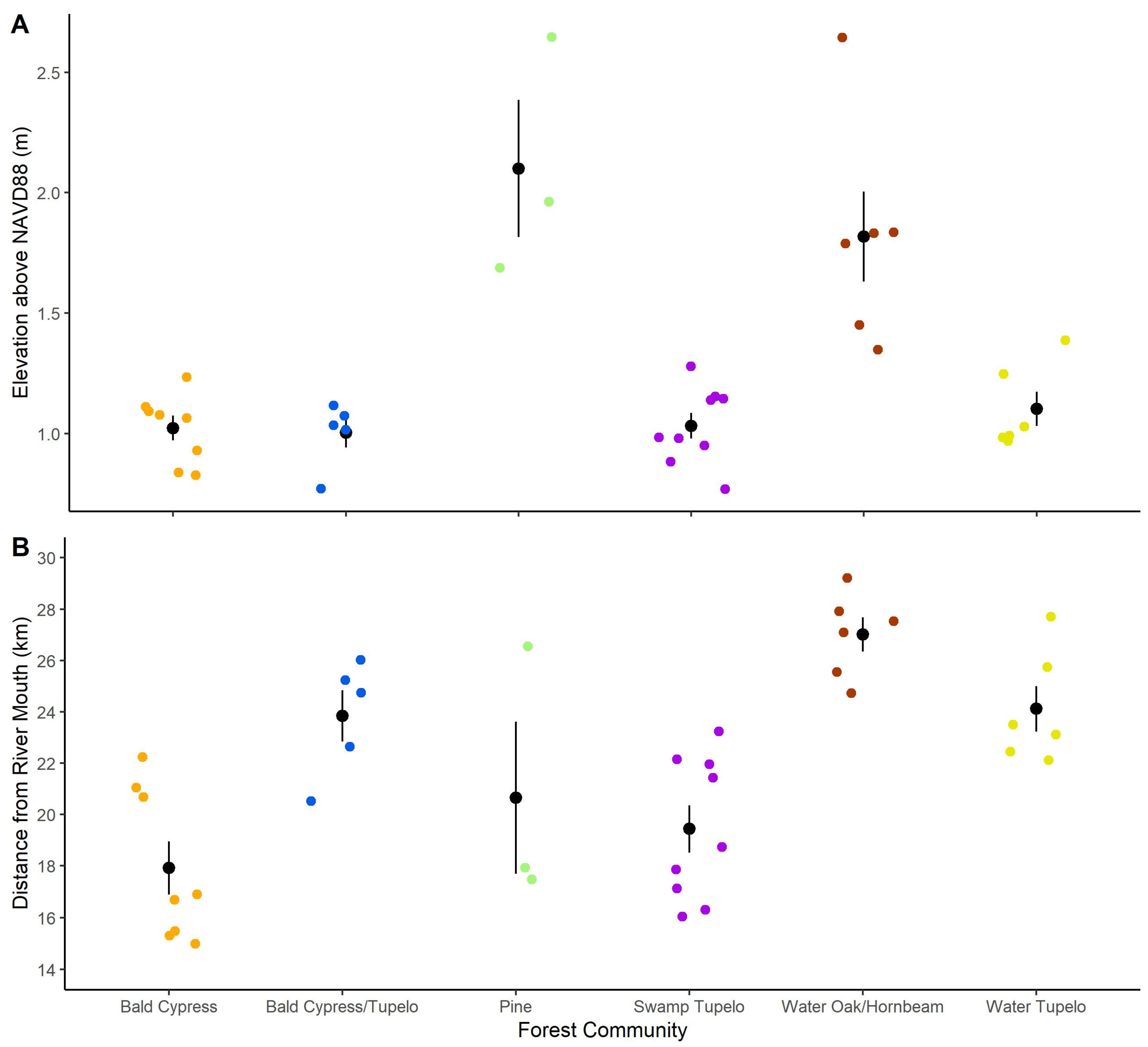
3.3. Community Descriptions

1.
Oak/Hornbeam
Plots in this community were concentrated at the upstream extent of our study area (Figure 7). Various compositions of oaks (Q. nigra, Q. lyrata Walter, Q. laurifolia Michx.) are the dominant canopy tree, accounting for 50% of IV (Table 1). Canopy coverage averaged 96%, among the highest of all our communities. Hornbeam (Carpinus caroliniana Walter) is uniquely abundant in the understory, along with sweetgum, which occasionally emerges as a canopy tree. Plots in this community had the second highest average elevation, at 1.82 m above NAVD88, based on a DEM (Table 1). The dominance of large, widely-spaced oak trees and sparse understory in this community give it the second lowest average basal area of any community: 41.1 m2·ha−1 (Table 1).
2.
Water Tupelo
This community was prevalent in the backswamp further from the riverbanks (Figure 7). The canopy is almost exclusively water tupelo (56% of IV), with some bald cypress (11% of IV) and oak (12% of IV) (Table 1). Water tupelo are generally mature and large in stature, with a maximum recorded height of 35 m. Canopy coverage is complete (averaging 97%). The understory is sparse but mainly ash and sweetgum. Herbaceous ground cover is variable. In less deeply flooded areas, lizard’s tail (Saururus cernuus L.) proliferates.
3.
Bald Cypress/Tupelo
This community was a mixture of bald cypress (37% of IV), water tupelo (23% of IV), and swamp tupelo (21% of IV), and was intermediate between the two tupelo and bald cypress communities in many respects (Table 1). These plots were located further upstream than those in the Bald Cypress Community (Figure 7). The greater abundance of tupelo resulted in a less open canopy (93% average canopy cover) and greater stem density (1256 stems·ha−1) than the Bald Cypress community’s 86% canopy cover and 668 stems·ha−1) (Table 1). Understory and herbaceous vegetation were most similar to the Swamp Tupelo Community. Ash (6% of IV) and sweetgum (6% of IV) were the most common understory trees, and lizard's tail was abundant in all plots (Table 1). Site flooding conditions were like those in the Swamp Tupelo and Bald Cypress communities, as all three of these communities were found within 1.0 to 1.1 m elevation above NAVD88 (Table 1).
4.
Pine
This community contains stands of pine trees (Pinus spp.) in managed forests or, in one case, on a spoil left over from highway construction (Figure 7). With 93% of IV, pine trees dominate almost to the exclusion of all other species, although sweetgum occurs as an understory tree or rarely in the canopy (Table 1). The pine trees are homogeneous in height and girth. Canopy coverage is complete (97.5%), and the underbrush is sparse, with occasional yaupon holly (Ilex vomitoria Ait.) being the most common shrubs. Herbaceous ground cover is minimal. This community had the highest average elevation, at 2.17 m above NAVD88 (Table 1).
5.
Swamp Tupelo
This was the most abundant community in our study area, typically occupying areas adjacent to the main channel of the river (Figure 7). The canopy is dominated by swamp tupelo (58% of IV), with sweetgum (7% of IV) and ash (20% of IV) occasionally emerging from the understory (Table 1). The abundance of these trees in the understory contributes to this community having the highest average density, at 1362 stems·ha−1. A dense network of surface roots creates low hummocks where less flood-tolerant vegetation, such as dwarf palmetto (Sabal minor [Jacq.] Pers.) or oaks, can establish. Ground cover is abundant, typically a mixture of lizard’s tail and pickerelweed (Pontederia cordata L.).
6.
Bald Cypress
These plots represent almost homogeneous stands of bald cypress (75% of IV). This community had one of the widest distributions along the tidal gradient and therefore included plots subjected to a wide range of salinity regimes. The presence of some salt-stressed plots in this community depresses values for basal area, density, and canopy coverage. At most sites, swamp tupelo is sparsely present in the understory or canopy (15% of IV) (Table 1). Where trees are not subject to salt stress, the uniformly tall canopy and complete canopy closure (>95% on average) largely exclude understory and underbrush species, but sweetgum, ash, and red maple are sometimes present. Ground cover is mainly lizard’s tail, dwarf palmetto, and pickerelweed. At plots near the downstream extent of our study area, bald cypress was sometimes the only living tree, and herbaceous vegetation was dominated by tidal fresh and brackish marsh species, particularly softstem bulrush (Schoenoplectus tabernaemontani [K.D. Gmel.] Palla) and giant cutgrass.

4. Discussion

4.1. Communities and Ecological Gradients

Understanding the current composition and distribution of TFF is critical to predicting the impact of climate change and sea level rise. In this study, we identified six distinct tidal freshwater forest communities (Table 1). Species composition differed significantly between our six communities and was significantly correlated with elevation and longitudinal river distance (Figure 7). Nonparametric comparisons between pairs (Dunn’s test) indicated that, with two exceptions, elevation does not differ significantly between communities. We suspect this reflects the combination of coarse-resolution and potentially inaccurate elevation data due to vegetation bias [50] and our limited number of observations, which increases the standard deviation of each community. However, the relationship between elevation and plot-level species composition identified in our NMDS ordination is strongly significant (r2 = 0.645, p = 0.001) (Figure 5). Ordination results also show that plot-level species composition is significantly associated with longitude (r2 = 0.545, p = 0.001), a proxy for distance upstream from the mouth of the Altamaha River estuary and its effect on salinity and flooding gradients [53].
Studies of TFF that define communities based on multivariate analysis of species composition are rare [9,12,49,54]. The most common approach is to delineate sites by degree of tidal influence and measure community composition at these sites [55,56,57,58]. Our decision to identify discrete communities based on species composition was intended to create a classification schema applicable to future remote sensing analyses, but these differing methodologies complicate comparisons between studies. Nevertheless, the TFF communities we identified (Figure 3, Table 1), and species relationships with ecological drivers (Figure 4, Figure 5 and Figure 7) correspond well with prior studies of TFF in Georgia and throughout the south-eastern United States [7,9,12,47,48,49].
Flood-tolerant tree species are largely excluded from upland areas due to competition from more vigorous upland vegetation [29,59]. Within the floodplain forest, species distributions are driven by salinity and small local changes in elevation, which strongly impacts flooding frequency and duration [7,29,53]. All TFF species have some degree of flood tolerance, but bald cypress is the best adapted to inundation, with established trees capable of growing in permanently flooded conditions [59]. Bald cypress, swamp tupelo, and water tupelo were the dominant species at low-elevation plots (Table 1, Figure 6), a pattern documented in prior studies [9,12,29,49,60,61]. At higher elevations within the floodplain, oak, sweetgum, and other less flood-tolerant species increase in importance (Table 1, Figure 7) [29,48,62]. On uplands adjacent to the floodplain, forests are composed of flood-intolerant species such as pines and live oak (Table 1, Figure 7). These general ecological gradients are consistent throughout TFF in the south-eastern United States, but are shorter in smaller volume drainages where tide and elevation are stronger influences than river discharge [25]. Exceptions to this pattern are found in areas with small tidal ranges and low river discharge, such as the Albemarle-Pimlico Peninsula in North Carolina and the Big Bend region of Florida’s Gulf coast. In these locations TFF are less abundant and less diverse, and are dominated by different species, particularly cabbage palm, Southern red cedar and wax myrtle [63,64]
Our Water Tupelo and Swamp Tupelo Communities appear to be homologous with communities of the same name identified by Duberstein, Conner and Krauss [12] from the Savannah and Altamaha Rivers, with similar species compositions, stem densities, and importance values. We found that swamp tupelo was most abundant on streambanks and in tidally influenced areas while water tupelo dominates the backswamp, a pattern consistent with findings from TFF on the Apalachicola and Suwannee Rivers [7,12,48,54,55]. TFF on the Pamunkey, Pocomoke, and Nanticoke rivers of the Chesapeake Bay are likewise dominated by swamp tupelo and water tupelo, but red maple is far more abundant in these communities than on the Altamaha [65,66,67,68].
Unlike prior surveys of the Altamaha [12,20], we identified two bald cypress-dominated communities (Table 1, Figure 3). Bald cypress is widely described as codominant with water tupelo in frequently or continuously flooded swamps throughout the Southeast [29,61,69]. In our fieldwork we encountered numerous sites where bald cypress grows in nearly monospecific stands, but these areas were patchily distributed, possibly reflecting natural gradients and disturbance history [29,48]. Previous studies of TFF communities on the Altamaha River sampled areas of the forest where bald cypress is less abundant [12,20]. In comparison to these studies, our field sampling sites were more widely distributed within the TFF, and our use of stratified random sampling based on a preliminary classification enabled us to deliberately target bald cypress-dominated areas.
Bald cypress has the highest tolerance for salinity and flooding among native TFF species, with mature bald cypress trees capable of growing in chronic salinities of 3–4 PSU [49,70]. Tupelo trees are more sensitive. In South Carolina TFF, water tupelo were completely absent at sites exceeding 2.2 PSU [70], and sweetgum, ash, and oak species have even lower salinity tolerance [28,71]. This likely explains bald cypress dominance in plots at the downstream extent of our study area where tidal freshwater forest intergrades with tidal freshwater marsh [58]. At some of our plots (337, 347, 348) bald cypress were the only mature living trees, and ash, swamp tupelo, and hazel alder, when present, were reduced to shrub-like stature due to salt stress (Figure 8). These plots were located downstream and proximal to the major distributaries of the lower Altamaha River (Figure 7), an area which has experienced TFF dieback over the past 20 years [72]. This type of salt-stressed forest is typical of the forest-marsh transition area on large rivers throughout the south-east [10,14,48,63,73]. This community structure may be a product of the “Ecological Ratchet” model of forest-marsh transition described by Fagherazzi et al. [74]. In this model, the boundary between tidal marsh and tidal forest advances upslope due to the interaction of chronic (press) and acute (pulse) stressors. Chronic stress caused by saltwater intrusion inhibits sapling recruitment and kills salt-intolerant species, moving the regeneration boundary landward. Mature trees of more salt-tolerant species survive in the “persistence zone” until subjected to acute stress (storm surge, hurricane winds), which completes the transition to marsh. This cycle progresses upslope over time at a rate dictated by topography, hydrology, and the salt tolerance of forest vegetation [74].
Salinity tolerance varies among TFF tree species and is a major driver of community composition in coastal wetlands [71,75]. Salinity-driven replacement of tidal freshwater forests by tidal marshes represents a substantial loss of biodiversity and a corresponding loss of ecosystem services [22,48]. In southeastern tidal freshwater forests, broadleaved trees (Fraxinus spp., Quercus spp., L. styraciflua, and N. aquatica) are most susceptible to saltwater intrusion [71,73]. Even moderate salinity (2–3 PSU) can cause mortality in these species, increasing the relative abundance of more salt-tolerant native species such as bald cypress, eastern red cedar, salt cedar, and sabal palmetto [48,63,70,76] and creating opportunities for invasive species, particularly Chinese tallow (Triadica sebifera [L.] Small) [77]. These lower-density, less-diverse transitional forests have less complex vertical structure and more open canopies, reducing the number of microhabitat niches that support other plants and animals (Figure 8) [48].
Root death due to saltwater intrusion precedes tree death [78], and this root zone collapse leads to a loss of elevation, which further accelerates colonization by marsh vegetation [21,79]. Once salt tolerant vegetation becomes established, it draws salty water into the root zone via evapotranspiration, further accelerating the decline of salt-intolerant species [79]. This study did not directly measure salinity or flooding, but data from GCE water-quality sondes in the river channel show that salinity adjacent to the tidal forest at GCE Site 11 (31.379402, −81.492804) remains fresh (less than 0.5 PSU) except for brief excursions during storm surges or periods of extremely low river discharge [80]. At GCE Site 8, just downstream of the forest–marsh boundary (31.310556, −81.409444) average salinity during our study period was 4.4 PSU with spikes as high as 16 PSU and month-long periods in excess of 6 PSU [81]. These salinities far exceed the chronic exposure tolerance of native tree species, which explains the absence of living trees at this point on the river [7,70].
Salinization of freshwater wetland soils increases rates of CO2 and CH4 emissions [82,83,84]. Trees growing at salinity-affected sites exhibit reduced leaf area and slower growth rates [14,85], leading to a reduction in carbon sequestration capacity which is not offset by the expansion of marsh vegetation [85]. Additionally, standing dead trees (“ghost forests”) release methane and other greenhouse gases [86,87]. Long-term expansion of tidal marshes can offset these emissions, but only if seaward marshes are not lost to open water [10]. Tidal freshwater forests in Georgia are projected to decline by 34% by 2100, a loss of 267 km2, replaced mainly by brackish marsh [22]. Some of this loss could be offset by tidal extension into previously non-tidal riparian forest, but the extent is unclear, and likely varies from river to river [83,88].

4.2. Implications and Future Work

Our results support previous studies examining the community composition and ecological drivers of TFF species distribution. Further, our results expand the applicability of prior studies of the Altamaha River by extending the spatial extent of our sampling regime. Such extensive ground-reference sampling is essential to scale plot-based observations to larger extents via remote sensing. The large extent, challenging conditions, and potentially rapid rates of change of TFF make remote sensing ideal for rapid, multi-temporal monitoring of TFF. Land cover classifications derived from remote sensing data are integral inputs for modelling coastal ecosystem responses to sea level rise (e.g., the “sea level affecting marshes model” (SLAMM)) [22]. Unfortunately, the most widely used landcover classification, the National Wetland Inventory (NWI), has a relatively coarse spatial and ecological resolution. Most NWI classes (e.g., “hardwood swamp”) are quite heterogeneous, containing numerous species with different salinity and flooding tolerances. Thus, ecologically and taxonomically detailed remote sensing classification is essential for accurate estimates of biomass, carbon storage, and greenhouse gas emissions. This study improves our ability to identify ecologically distinct TFF communities across the entire range of tidal influence and relate them to salinity and flooding ecological gradients. In the future, we will be able to directly use these findings to map TFF using remote sensing.

5. Conclusions

We identified six distinct TFF communities comparable with existing studies. Species distributions (but not community identity) were significantly correlated with elevation and river distance, proxies for flooding and salinity. Existing models of sea level rise tend to treat TFF as a homogeneous entity, potentially leading to errors in predicted rates of retreat and carbon storage capacity. This study is the first to sample TFF on the Altamaha River, GA across the full range of tidal influence, and represents the first step towards mapping an ecosystem threatened by sea level rise and saltwater intrusion.

Author Contributions

Conceptualization, G.C. and C.M.H.; methodology, G.C. and C.M.H.; formal analysis, G.C.; writing—original draft preparation, G.C.; writing—review and editing, C.M.H. and C.C.; visualization, G.C.; supervision, C.M.H. and C.C.; project administration, C.M.H.; funding acquisition, C.M.H. All authors have read and agreed to the published version of the manuscript.

Funding

This research was funded by the National Science Foundation, grant number 1832178.

Data Availability Statement

Access to documented data sets and other information will be provided on the GCE LTER website and NSF-approved data repositories (e.g., EDI Data Portal, DataONE).

Conflicts of Interest

The authors declare no conflicts of interest.

References

  1. Doyle, T.W.; O'Neil, C.P.; Melder, M.P.V.; From, A.S.; Palta, M.M. Tidal Freshwater Swamps of the Southeastern United States: Effects of Land Use, Hurricanes, Sea-Level Rise, and Climate Change. In Ecology of Tidal Freshwater Forested Wetlands of the Southeastern United States; Conner, W.H., Doyle, T.W., Krauss, K.W., Eds.; Springer: Berlin/Heidelberg, Germany, 2007; pp. 1–28. [Google Scholar]
  2. Grieger, R.; Capon, S.J.; Hadwen, W.L.; Mackey, B. Between a bog and a hard place: A global review of climate change effects on coastal freshwater wetlands. Clim. Change 2020, 163, 161–179. [Google Scholar] [CrossRef]
  3. Ury, E.A.; Yang, X.; Wright, J.P.; Bernhardt, E.S. Rapid deforestation of a coastal landscape driven by sea-level rise and extreme events. Ecol. Appl. 2021, 31, e02339. [Google Scholar] [CrossRef]
  4. Chen, Y.; Kirwan, M.L. A phenology-and trend-based approach for accurate mapping of sea-level driven coastal forest retreat. Remote Sens. Environ. 2022, 281, 113229. [Google Scholar] [CrossRef]
  5. Schieder, N.W.; Walters, D.C.; Kirwan, M.L. Massive upland to wetland conversion compensated for historical marsh loss in Chesapeake Bay, USA. Estuaries Coasts 2018, 41, 940–951. [Google Scholar] [CrossRef]
  6. Gedan, K.B.; Epanchin-Niell, R.; Qi, M. Rapid land cover change in a submerging coastal county. Wetlands 2020, 40, 1717–1728. [Google Scholar] [CrossRef]
  7. Anderson, C.J.; Lockaby, B.G.; Click, N. Changes in wetland forest structure, basal growth, and composition across a tidal gradient. Am. Midl. Nat. 2013, 170, 1–13. [Google Scholar] [CrossRef]
  8. Barendregt, A.; Swarth, C.W. Tidal Freshwater Wetlands: Variation and Changes. Estuaries Coasts 2013, 36, 445–456. [Google Scholar] [CrossRef]
  9. Duberstein, J.; Kitchens, W. Community composition of select areas of tidal freshwater forest along the Savannah River. In Ecology of Tidal Freshwater Forested Wetlands of the Southeastern United States; Springer: Berlin/Heidelberg, Germany, 2007; pp. 321–348. [Google Scholar]
  10. Smart, L.S.; Taillie, P.J.; Poulter, B.; Vukomanovic, J.; Singh, K.K.; Swenson, J.J.; Mitasova, H.; Smith, J.W.; Meentemeyer, R.K. Aboveground carbon loss associated with the spread of ghost forests as sea levels rise. Environ. Res. Lett. 2020, 15, 104028. [Google Scholar] [CrossRef]
  11. Craft, C. Tidal freshwater forest accretion does not keep pace with sea level rise. Glob. Change Biol. 2012, 18, 3615–3623. [Google Scholar] [CrossRef]
  12. Duberstein, J.A.; Conner, W.H.; Krauss, K.W. Woody vegetation communities of tidal freshwater swamps in South Carolina, Georgia and Florida (US) with comparisons to similar systems in the US and South America. J. Veg. Sci. 2014, 25, 848–862. [Google Scholar] [CrossRef]
  13. Huylenbroeck, L.; Laslier, M.; Dufour, S.; Georges, B.; Lejeune, P.; Michez, A. Using remote sensing to characterize riparian vegetation: A review of available tools and perspectives for managers. J. Environ. Manag. 2020, 267, 110652. [Google Scholar] [CrossRef]
  14. Shaffer, G.P.; Wood, W.B.; Hoeppner, S.S.; Perkins, T.E.; Zoller, J.; Kandalepas, D. Degradation of baldcypress–water tupelo swamp to marsh and open water in southeastern Louisiana, USA: An irreversible trajectory? J. Coast. Res. 2009, 54, 152–165. [Google Scholar] [CrossRef]
  15. Mcleod, E.; Chmura, G.L.; Bouillon, S.; Salm, R.; Björk, M.; Duarte, C.M.; Lovelock, C.E.; Schlesinger, W.H.; Silliman, B.R. A blueprint for blue carbon: Toward an improved understanding of the role of vegetated coastal habitats in sequestering CO2. Front. Ecol. Environ. 2011, 9, 552–560. [Google Scholar] [CrossRef]
  16. Stevenson, D.J.; Chandler, H.C. The herpetofauna of conservation lands along the Altamaha River, Georgia. Southeast. Nat. 2017, 16, 261–282. [Google Scholar] [CrossRef]
  17. Alexander, C.; Hladik, C. High-Resolution Mapping of Vegetation, Elevation, Salinity and Bathymetry to Advance Coastal Habitat Management in Georgia; University of Georgia: Athens, GA, USA, 2015. [Google Scholar]
  18. Higinbotham, C.B.; Alber, M.; Chalmers, A.G. Analysis of tidal marsh vegetation patterns in two Georgia estuaries using aerial photography and GIS. Estuaries 2004, 27, 670–683. [Google Scholar] [CrossRef]
  19. White, S.N.; Alber, M. Drought-associated shifts in Spartina alterniflora and S. cynosuroides in the Altamaha River estuary. Wetlands 2009, 29, 215–224. [Google Scholar] [CrossRef]
  20. Stahl, M.; Widney, S.; Craft, C. Tidal freshwater forests: Sentinels for climate change. Ecol. Eng. 2018, 116, 104–109. [Google Scholar] [CrossRef]
  21. Carr, J.; Guntenspergen, G.; Kirwan, M. Modeling Marsh-Forest Boundary Transgression in Response to Storms and Sea-Level Rise. Geophys. Res. Lett. 2020, 47, e2020GL088998. [Google Scholar] [CrossRef]
  22. Craft, C.; Clough, J.; Ehman, J.; Joye, S.; Park, R.; Pennings, S.; Guo, H.; Machmuller, M. Forecasting the effects of accelerated sea-level rise on tidal marsh ecosystem services. Front. Ecol. Environ. 2009, 7, 73–78. [Google Scholar] [CrossRef]
  23. Zinnert, J.C.; Nippert, J.B.; Rudgers, J.A.; Pennings, S.C.; González, G.; Alber, M.; Baer, S.G.; Blair, J.M.; Burd, A.; Collins, S.L. State changes: Insights from the US Long Term Ecological Research Network. Ecosphere 2021, 12, e03433. [Google Scholar] [CrossRef]
  24. Jayakaran, A.; Williams, T.; Conner, W.; Hitchcock, D.; Song, B.; Chow, A.; Smith, E. Monitoring water quality changes in a forested freshwater wetland threatened by salinity. In Proceedings of the 2014 South Carolina Water Resources Conference, Columbia, SC, USA, 15–16 October 2014. [Google Scholar]
  25. Conner, W.; Whitmire, S.; Duberstein, J.; Stalter, R.; Baden, J. Changes within a South Carolina coastal wetland forest in the face of rising sea level. Forests 2022, 13, 414. [Google Scholar] [CrossRef]
  26. NOAA Tides and Currents. Champney Island, South Altamaha River, GA-Station ID: 8676012. Available online: https://tidesandcurrents.noaa.gov/stationhome.html?id=8676012 (accessed on 2 January 2023).
  27. Alber, M.; Alexander, C.; Craft, C.; Hladik, C.M.; Medieros, P.M.; Pennings, S.C. RAPID: 2017 Hurricane Irma: How Do the Effects of Pulse Disturbance Caused by Hurricanes Vary with Abiotic Conditions, Disturbance History and Proximity to a Transition Zone; Final Report Submitted to NSF; NSF: Alexandria, VA, USA, 2019; p. 15. [Google Scholar]
  28. Conner, W.H.; Krauss, K.W.; Doyle, T.W. Ecology of Tidal Freshwater Forests in Coastal Deltaic Louisiana and Northeastern South Carolina. In Ecology of Tidal Freshwater Forested Wetlands of the Southeastern United States; Conner, W.H., Doyle, T.W., Krauss, K.W., Eds.; Springer: Dordrecht, The Netherlands, 2007; pp. 223–253. [Google Scholar]
  29. Wharton, C.H.; Kitchens, W.M.; Pendleton, E.C.; Sipe, T.W. The Ecology of Bottomland Hardwood Swamps of the Southeast: A Community Profile; U.S. Forest Service, U.S. Department of Agriculture: Washington, DC, USA, 1982. [Google Scholar]
  30. Carpenter, J.; Meehan, C. Georgia Coastal Ecosystems LTER Domain; University of Georgia: Athens, GA, USA, 2009. [Google Scholar]
  31. Anderson, C.J.; Lockaby, B.G. Soils and biogeochemistry of tidal freshwater forested wetlands. In Ecology of Tidal Freshwater Forested Wetlands of the Southeastern United States; Springer: Berlin/Heidelberg, Germany, 2007; pp. 65–88. [Google Scholar]
  32. NRCS Web Soil Survey. Natural Resources Conservation Service; United States Department of Agriculture: Washington, DC, USA, 2021. [Google Scholar]
  33. Odum, W.E.; Smith, T.J., III; Hoover, J.K.; McIvor, C.C. The Ecology of Tidal Freshwater Marshes of the United States East Coast: A Community Profile; U.S. Fish and Wildlife Service: Washington, DC, USA, 1984; p. 177. [Google Scholar]
  34. Tully, K.; Gedan, K.; Epanchin-Niell, R.; Strong, A.; Bernhardt, E.S.; BenDor, T.; Mitchell, M.; Kominoski, J.; Jordan, T.E.; Neubauer, S.C. The invisible flood: The chemistry, ecology, and social implications of coastal saltwater intrusion. BioScience 2019, 69, 368–378. [Google Scholar] [CrossRef]
  35. Herbert, E.R.; Boon, P.; Burgin, A.J.; Neubauer, S.C.; Franklin, R.B.; Ardón, M.; Hopfensperger, K.N.; Lamers, L.P.; Gell, P. A global perspective on wetland salinization: Ecological consequences of a growing threat to freshwater wetlands. Ecosphere 2015, 6, 1–43. [Google Scholar] [CrossRef]
  36. R Core Team. R: A Language and Environment for Statistical Computing; R Foundation for Statistical Computing: Vienna, Austria, 2021; Available online: https://www.R-project.org/ (accessed on 2 January 2023).
  37. Curtis, J.T.; McIntosh, R.P. An Upland Forest Continuum in the Prarie-Forest Border Region of Wisconsin. Ecology 1951, 32, 20. [Google Scholar] [CrossRef]
  38. Tobe, J.D. Florida Wetland Plants: An Identification Manual; University Press of Florida: Gainesville, FL, USA, 1998. [Google Scholar]
  39. McCune, B.; Grace, J.B. Analysis of Ecological Communities; MjM Software Design: Gleneden Beach, OR, USA, 2002; Volume 28. [Google Scholar]
  40. Legendre, P.; De Cáceres, M. Beta diversity as the variance of community data: Dissimilarity coefficients and partitioning. Ecol. Lett. 2013, 16, 951–963. [Google Scholar] [CrossRef]
  41. Legendre, P.; Gallagher, E.D. Ecologically meaningful transformations for ordination of species data. Oecologia 2001, 192, 271–280. [Google Scholar] [CrossRef]
  42. Oksanen, J.; Blanchet, F.G.; Friendly, M.; Kindt, R.; Legendre, P.; McGlinn, D.; Minchin, P.R.; O'Hara, R.B.; Simpson, G.L.; Solymos, P.; et al. Vegan: Community Ecology Package. Version 2.6-4. 2022. Available online: https://CRAN.R-project.org/package=vegan (accessed on 12 July 2022).
  43. Kassambara, A.; Mundt, F. Factoextra: Extract and Visualize the Results of Multivariate Data Analyses. Version 1.0.7. 2020. Available online: https://CRAN.R-project.org/package=factoextra (accessed on 11 September 2022).
  44. Milligan, G.W.; Cooper, M.C. An Examination of Procedures for Determining the Number of Clusters in a Data Set. Psychometrika 1985, 50, 159–179. [Google Scholar] [CrossRef]
  45. Dufrêne, M.; Legendre, P. Species assemblages and indicator species: The need for a flexible asymmetrical approach. Ecol. Monogr. 1997, 67, 345–366. [Google Scholar] [CrossRef]
  46. De Câceres, M.; Legendre, P. Associations between species and groups of sites: Indices and statistical inference. Ecology 2009, 90, 3566–3574. [Google Scholar] [CrossRef]
  47. Conner, W.H.; Song, B.; Williams, T.M.; Vernon, J.T. Long-term tree productivity of a South Carolina coastal plain forest across a hydrology gradient. J. Plant Ecol. 2011, 4, 67–76. [Google Scholar] [CrossRef]
  48. Light, H.M.; Darst, M.R.; Lewis, L.J.; Howell, D.A. Hydrology, Vegetation, and Soils of Riverine and Tidal Floodplain Forests of the Lower Suwannee River, Florida, and Potential Impacts of Flow Reductions; US Geological Survey: Reston, VA, USA, 2002; ISSN 2330-7102. [Google Scholar]
  49. Krauss, K.W.; Duberstein, J.A.; Doyle, T.W.; Conner, W.H.; Day, R.H.; Inabinette, L.W.; Whitbeck, J.L. Site condition, structure, and growth of baldcypress along tidal/non-tidal salinity gradients. Wetlands 2009, 29, 505–519. [Google Scholar] [CrossRef]
  50. Hladik, C.; Alber, M. Accuracy assessment and correction of a LIDAR-derived salt marsh digital elevation model. Remote Sens. Environ. 2012, 121, 224–235. [Google Scholar] [CrossRef]
  51. Dunn, O.J. Multiple comparisons using rank sums. Technometrics 1964, 6, 241–252. [Google Scholar] [CrossRef]
  52. Clarke, K.R. Non-parametric multivariate analyses of changes in community structure. Aust. J. Ecol. 1993, 18, 117–143. [Google Scholar] [CrossRef]
  53. Flitcroft, R.; Clinton, P.; Christiansen, K. Adding to the toolbox for tidal-inundation mapping in estuarine areas. J. Coast. Conserv. 2018, 22, 745–753. [Google Scholar] [CrossRef] [PubMed]
  54. Anderson, C.J.; Lockaby, B.G. Forested wetland communities as indicators of tidal influence along the Apalachicola River, Florida, USA. Wetlands 2011, 31, 895–906. [Google Scholar] [CrossRef]
  55. Celik, S.; Anderson, C.J.; Kalin, L.; Rezaeianzadeh, M. Long-term salinity, hydrology, and forested wetlands along a tidal freshwater gradient. Estuaries Coasts 2021, 44, 1816–1830. [Google Scholar] [CrossRef]
  56. Cormier, N.; Krauss, K.W.; Conner, W.H. Periodicity in stem growth and litterfall in tidal freshwater forested wetlands: Influence of salinity and drought on nitrogen recycling. Estuaries Coasts 2013, 36, 533–546. [Google Scholar] [CrossRef]
  57. Ensign, S.H.; Hupp, C.R.; Noe, G.B.; Krauss, K.W.; Stagg, C.L. Sediment accretion in tidal freshwater forests and oligohaline marshes of the Waccamaw and Savannah Rivers, USA. Estuaries Coasts 2014, 37, 1107–1119. [Google Scholar] [CrossRef]
  58. Liu, X.; Conner, W.H.; Song, B.; Jayakaran, A.D. Forest composition and growth in a freshwater forested wetland community across a salinity gradient in South Carolina, USA. For. Ecol. Manag. 2017, 389, 211–219. [Google Scholar] [CrossRef]
  59. Beane, N.R. Baldcypress (Taxodium Distichum) at the Wallisville Lake Project: A Review of Applicable Literature and Management Considerations; US Army Corps of Engineers Engineer Research and Development Center: Vicksburg, MI, USA, 2020. [Google Scholar]
  60. Day, R.H.; Williams, T.M.; Swarzenski, C.M. Hydrology of tidal freshwater forested wetlands of the southeastern United States. In Ecology of Tidal Freshwater Forested Wetlands of the Southeastern United States; Springer: Berlin/Heidelberg, Germany, 2007; pp. 29–63. [Google Scholar]
  61. Tiner, R.W. Tidal Wetlands Primer: An Introduction to Their Ecology. Natural History, Status, and Conservation; University of Massachusetts Press: Amherst, MA, USA, 2013. [Google Scholar]
  62. Sharitz, R.R.; Lee, L.C. Limits on Regeneration Processes in Southeastern Riverine Wetlands. In Proceedings of the Riparian Ecosystems and Their Management: Reconciling Conflicting Uses, Tucson, AZ, USA, 16–18 April 1985. [Google Scholar]
  63. Williams, K.; Ewel, K.C.; Stumpf, R.P.; Putz, F.E.; Workman, T.W. Sea-level rise and coastal forest retreat on the west coast of Florida, USA. Ecology 1999, 80, 2045–2063. [Google Scholar] [CrossRef]
  64. Desantis, L.R.; Bhotika, S.; Williams, K.; Putz, F.E. Sea-level rise and drought interactions accelerate forest decline on the Gulf Coast of Florida, USA. Glob. Change Biol. 2007, 13, 2349–2360. [Google Scholar] [CrossRef]
  65. Conner, W.H.; Doyle, T.W.; Krauss, K.W.; Kroes, D.E.; Hupp, C.R.; Noe, G.B. Sediment, nutrient, and vegetation trends along the tidal, forested Pocomoke River, Maryland. In Ecology of Tidal Freshwater Forested Wetlands of the Southeastern United States; Springer: Berlin/Heidelberg, Germany, 2007; pp. 113–137. [Google Scholar]
  66. Middleton, B.A. Differences in impacts of Hurricane Sandy on freshwater swamps on the Delmarva Peninsula, Mid-Atlantic Coast, USA. Ecol. Eng. 2016, 87, 62–70. [Google Scholar] [CrossRef]
  67. Middleton, B.A.; Souter, N.J. Functional integrity of freshwater forested wetlands, hydrologic alteration, and climate change. Ecosyst. Health Sustain. 2016, 2, e01200. [Google Scholar] [CrossRef]
  68. Noe, G.B.; Bourg, N.A.; Krauss, K.W.; Duberstein, J.A.; Hupp, C.R. Watershed and estuarine controls both influence plant Community and tree growth changes in tidal freshwater forested wetlands along two US Mid-Atlantic Rivers. Forests 2021, 12, 1182. [Google Scholar] [CrossRef]
  69. Larson, J.S.; Bedinger, M.; Bryan, C.F.; Brown, S.; Huffman, R.T.; Miller, E.L.; Rhodes, D.G.; Touchet, B.A. Transition from wetlands to uplands in southeastern bottomland hardwood forests. In Developments in Agricultural and Managed Forest Ecology; Elsevier: Amsterdam, The Netherlands, 1981; Volume 11, pp. 225–273. [Google Scholar]
  70. Duberstein, J.A.; Krauss, K.W.; Baldwin, M.J.; Allen, S.T.; Conner, W.H.; Salter Jr, J.S.; Miloshis, M. Small gradients in salinity have large effects on stand water use in freshwater wetland forests. For. Ecol. Manag. 2020, 473, 118308. [Google Scholar] [CrossRef]
  71. Krauss, K.W.; Chambers, J.L.; Creech, D. Selection for Salt Tolerance in Tidal Freshwater Swamp Species: Advances Using Baldcypress as a Model for Restoration. In Ecology of Tidal Freshwater Forested Wetlands of the Southeastern United States; Conner, W.H., Doyle, T.W., Krauss, K.W., Eds.; Springer: Dordrecht, The Netherlands, 2007; pp. 385–410. [Google Scholar]
  72. Craft, C.; Indiana University, Bloomington IN, USA. Personal Communication, 2024.
  73. Conner, W.H.; Doyle, T.W.; Krauss, K.W.; Hackney, C.T.; Avery, G.B.; Leonard, L.A.; Posey, M.; Alphin, T. Biological, chemical, and physical characteristics of tidal freshwater swamp forests of the Lower Cape Fear River/Estuary, North Carolina. In Ecology of Tidal Freshwater Forested Wetlands of the Southeastern United States; Springer: Berlin/Heidelberg, Germany, 2007; pp. 183–221. [Google Scholar]
  74. Fagherazzi, S.; Anisfeld, S.C.; Blum, L.K.; Long, E.V.; Feagin, R.A.; Fernandes, A.; Kearney, W.S.; Williams, K. Sea level rise and the dynamics of the marsh-upland boundary. Front. Environ. Sci. 2019, 7, 25. [Google Scholar] [CrossRef]
  75. Mitsch, W.J.; Gosselink, J.G. Wetlands, 2nd ed.; Van Nostrand Reinhold: New York, NY, USA, 1993. [Google Scholar]
  76. Raabe, E.A.; Stumpf, R.P. Expansion of tidal marsh in response to sea-level rise: Gulf Coast of Florida, USA. Estuaries Coasts 2015, 39, 145–157. [Google Scholar] [CrossRef]
  77. Conner, W.H.; Askew, G.R. Impact of saltwater flooding on red maple, redbay, and Chinese tallow seedlings. Castanea 1993, 58, 214–219. [Google Scholar]
  78. McDowell, N.G.; Ball, M.; Bond-Lamberty, B.; Kirwan, M.L.; Krauss, K.W.; Megonigal, J.P.; Mencuccini, M.; Ward, N.D.; Weintraub, M.N.; Bailey, V. Processes and mechanisms of coastal woody-plant mortality. Glob. Change Biol. 2022, 28, 5881–5900. [Google Scholar] [CrossRef]
  79. Middleton, B.A.; David, J.L. Trends in vegetation and height of the topographic surface in a tidal freshwater swamp experiencing rooting zone saltwater intrusion. Ecol. Indic. 2022, 145, 109637. [Google Scholar] [CrossRef]
  80. Di Iorio, D. Continuous Salinity, Temperature and Depth Measurements from Moored Hydrographic Data Loggers Deployed at GCE11_Hydro (Altamaha River Near Lewis Creek, Georgia) from 07-Oct-2017 through 31-Dec-2017; Georgia Coastal Ecosystems LTER Data Portal: Athens, GA, USA, 2018. [Google Scholar] [CrossRef]
  81. Di Iorio, D. Long-Term Hydrographic Mooring Data from the Georgia Coastal Ecosystems LTER Salinity Monitoring Program-Primary 30 Minute Observational Data; Georgia Coastal Ecosystems LTER Project, Ed.; University of Georgia, Long Term Ecological Research Network: Athens, GA, USA, 2016. [Google Scholar] [CrossRef]
  82. Marton, J.M.; Herbert, E.R.; Craft, C.B. Effects of salinity on denitrification and greenhouse gas production from laboratory-incubated tidal forest soils. Wetlands 2012, 32, 347–357. [Google Scholar] [CrossRef]
  83. Neubauer, S.C.; Craft, C.B. Global change and tidal freshwater wetlands: Scenarios and impacts. In Tidal Freshwater Wetlands; Springer: Berlin/Heidelberg, Germany, 2009; pp. 253–266. [Google Scholar]
  84. Seyfried, G.S.; Chow, A.T.; O'Halloran, T.L. Salinization, inundation and tree mortality interact to affect greenhouse gas emissions from stressed coastal forests. Soil Biol. Biochem. 2023, 184, 109101. [Google Scholar] [CrossRef]
  85. Pierfelice, K.N.; Graeme Lockaby, B.; Krauss, K.W.; Conner, W.H.; Noe, G.B.; Ricker, M.C. Salinity influences on aboveground and belowground net primary productivity in tidal wetlands. J. Hydrol. Eng. 2017, 22, D5015002. [Google Scholar] [CrossRef]
  86. Martinez, M.; Ardon, M. Drivers of greenhouse gas emissions from standing dead trees in ghost forests. Biogeochemistry 2021, 154, 471–488. [Google Scholar] [CrossRef]
  87. Martinez, M.; Ardón, M.; Carmichael, M.J. Identifying Sources and Oxidation of Methane in Standing Dead Trees in Freshwater Forested Wetlands. Front. Environ. Sci. 2022, 9, 701. [Google Scholar] [CrossRef]
  88. Ensign, S.H.; Noe, G.B. Tidal extension and sea-level rise: Recommendations for a research agenda. Front. Ecol. Environ. 2018, 16, 37–43. [Google Scholar] [CrossRef]
Figure 1. Study area (delineated in black) with plot locations on the Altamaha River, Georgia. Plot locations (red stars) are overlaid on the National Wetland Inventory (NWI) map of the area. The red diamond marks the location of the salinity and water depth sensors at Georgia Coastal Ecosystems Long-Term Ecological Research (GCE LTER) site 11.
Forests 15 00200 g001
Figure 2. Plot-level species importance values (IV) for 37 sampling locations on the Altamaha River, GA. Bars represent the cumulative IV of all species in each plot. For clarity, only the eight species with the highest total IV across all plots are shown.
Forests 15 00200 g002
Figure 3. Dendrogram produced via hierarchical clustering using Hellinger distance and Ward linkage for 16 tree species from 37 plots in the Altamaha TFF. Plot names are listed on the right and community names are given for each of the six groups.
Forests 15 00200 g003
Figure 4. Summary of results of indicator species analyses. Hierarchical clustering was used to group plots (N = 37) into 2–10 clusters. For each clustering level, an indicator value index (IVI) was calculated for each species. p-values were derived from 1000 Monte Carlo simulations with randomized data, then totaled for all species at each grouping level (x axis). The final pruning level of six clusters was selected to maximize the number of significant indicator species and minimize total p while giving reasonable ecological interpretation.
Forests 15 00200 g004
Figure 5. NMDS ordination of plots in species space. A two-dimensional solution was optimal. Shaded polygons indicate the communities identified through hierarchical clustering. Biplot overlays indicate the relationship of elevation in meters above NAVD88 and longitude (as a proxy for river distance) to plot ordination. Both elevation (r2 = 0.645) and longitude (r2 = 0.545) were significantly correlated with both axes (p = 0.001).
Forests 15 00200 g005
Figure 6. Distribution of plot elevation in meters (A) and longitude (a proxy for distance from river mouth in km) (B) for each of our six tidal freshwater forest communities. Plots are represented by colored points. Black circles are the mean for each community, and vertical bars show the standard error. Dunn’s test for multiple comparisons indicated that the only significant differences in elevation were between the Bald Cypress and Water Oak/Hornbeam Communities (p = 0.026) and Swamp Tupelo and Water Oak/Hornbeam Communities (p = 0.027). Differences in distance from river mouth were only significant for Bald Cypress and Water Oak/Hornbeam (p = 0.001) and Swamp Tupelo and Water Oak/Hornbeam Communities (p = 0.008).
Forests 15 00200 g006
Figure 7. Distribution of tidal freshwater forest communities identified via hierarchical clustering. Plots 331 and 350 were excluded from analyses based on outlier analysis.
Forests 15 00200 g007
Figure 8. Comparison of healthy and salt-stressed tidal forest canopy and understory vegetation for the bald cypress community (A,B) and swamp tupelo community (C,D). Healthy plots are on the left; salt-stressed plots are on the right. Plots shown are 326 (A), 346 (D), 345 (C), and 347 (B).
Forests 15 00200 g008
Table 1. Mean importance values for trees in each community. Bolded numbers are dominant species that totalled more than 50% of the importance in each community. Basal area and stem density values are the average for the listed species only.
SpeciesCommon NameCommunity
Oak/HornbeamWater TupeloBald Cypress/TupeloPineSwamp TupeloBald Cypress
Acer rubrumRed maple0.040.010.020.000.030.02
Alnus serrulataHazel alder0.000.000.010.000.000.00
Betula nigraRiver birch0.010.000.010.000.000.00
Carya aquaticaWater hickory0.020.000.000.000.000.00
Carpinus carolinianaAmerican hornbeam 0.04 0.000.010.000.000.00
Fraxinus spp.Ash0.02 0.07 0.060.000.200.07
Liquidambar styracifluaSweetgum0.100.070.060.070.070.02
Nyssa aquaticaWater tupelo0.01 0.56 0.230.000.030.00
Nyssa bifloraSwamp tupelo0.090.040.210.000.580.15
Persea palustrisSwamp bay0.000.000.000.000.010.00
Pinus spp.Pine0.080.000.000.930.000.00
Planera aquaticaWater elm0.010.000.010.000.000.00
Quercus laurifolia/nigraWater oak/laurel oak 0.50 0.120.020.000.020.00
Taxodium distichumBald cypress0.060.110.370.000.100.75
Ulmus americanaAmerican elm0.010.000.010.000.000.00
Number of Plots665398
Average Elevation (m above NAVD88)1.821.101.002.101.031.02
Basal area (m2·ha−1)41.172.968.142.047.237.2
Density (stems·ha−1)11401113125610331362668
Mean Canopy Coverage (%)95.997.192.997.583.085.5
Disclaimer/Publisher’s Note: The statements, opinions and data contained in all publications are solely those of the individual author(s) and contributor(s) and not of MDPI and/or the editor(s). MDPI and/or the editor(s) disclaim responsibility for any injury to people or property resulting from any ideas, methods, instructions or products referred to in the content.

