Article

Combining Traditional Ecological Knowledge and Scientific Observations to Support Mangrove Restoration in Madagascar

by
Lalao Aigrette Ravaoarinorotsihoarana
1,2,*,
Ismael Ratefinjanahary
1,
Celestin Aina
1,
Cicelin Rakotomahazo
1,2,
Leah Glass
1,
Lantoasinoro Ranivoarivelo
2 and
Thierry Lavitra
2
1
Blue Ventures Conservation, Villa Huguette-Lot II U 86, Cite Planton, Etienne Planton Road, Antananarivo 101, Madagascar
2
Institut Halieutiques et de Science Marines (IH.SM), Université de Toliara, BP141-Route du Port, Avenue de France, Toliara 601, Madagascar
*
Author to whom correspondence should be addressed.
Forests 2023, 14(7), 1368; https://doi.org/10.3390/f14071368
Submission received: 14 April 2023 / Revised: 15 June 2023 / Accepted: 26 June 2023 / Published: 3 July 2023
(This article belongs to the Special Issue Ecosystem Degradation and Restoration: From Assessment to Practice)

Abstract

:
Local communities play a key role in ecosystem restoration due to their invaluable traditional ecological knowledge. While community-led mangrove restoration has been practiced in Madagascar for decades, the factors influencing the success of the restoration remains understudied. Despite the extensive local knowledge, the complexity of factors influencing restoration success requires outside technical expertise. This study aimed to investigate the drivers of mangrove restoration success in southwest Madagascar. The survival rate of mangroves planted from 2015 to 2022, including Rhizophora mucronata, Bruguiera gymnorrhiza, and Ceriops tagal was assessed using the sampling methods for tree planting inventory with circular plots. R version 4.2.2 was used for descriptive statistics analysis. The correlation between the survival rate and plantation density, species composition, and number of participants was assessed using a Principal Component Analysis. As a result, the mean survival rate of the 440,990 planted mangroves, with a density of 4628 ± 317 trees/ha−1 was 82.5 ± 1.8%. Our study showed that plantation density and species composition are not correlated with survival rate. However, the survival rate is inversely correlated with the number of participants. The findings of this paper showed that both traditional ecological knowledge and scientific observations are vital to informing mangrove reforestation.

1. Introduction

Mangroves fulfill important socioeconomic and environmental functions and provide multidimensional benefits to both humans and wildlife [1,2]. A wide range of goods and services provided by mangroves include but are not limited to: the provision of wood and non-timber forest products [3]; coastal protection against the effects of wind, waves, and currents [4,5]; protection of coral reefs and seagrass beds; provision of habitat, spawning grounds for a variety of fish, and a shelter for biodiversity such as birds [2,6]. In addition, mangroves provide an important buffer against climate change due to their significant capacity to store carbon [7,8,9]. Despite their importance, mangrove forests in many parts of the world have been lost or degraded. It is estimated that, between 2010 and 2020, 1.04 million ha of global mangrove forest has been lost, equating to an average annual loss of 21,200 ha [10]. The loss and declining condition of mangroves have placed the livelihood of local communities and biodiversity at risk as well as contributed to climate change [11,12]. If mangroves are degraded, the carbon stored in the soil is released, resulting in carbon dioxide being emitted back into the atmosphere [13,14]. Aware of the critical need to halt, prevent and reverse ecosystem degradation, and to effectively restore degraded terrestrial and marine ecosystems across the globe, through Resolution 73/284, the United Nations General Assembly declared 2021–2030 as the United Nations Decade on Ecosystem Restoration [15]. The conservation and restoration of mangrove forests have been recognized as some of the most effective global management options for reversing and mitigating the effects of past loss [16,17]. These actions help maintain current and compensate for degraded, ecosystem goods and services that mangroves provide [18,19]. Mangrove restoration has been practiced for decades as a direct response to the degradation and destruction of this ecosystem [16,20]. Restoration strategies can be classified into (i) passive restoration which relies exclusively on natural processes to occur in an ecosystem after removing a source of disturbance; and (ii) active restoration where intervention techniques are used, such as artificial regeneration entails direct planting of desired propagules and saplings [21]. Some studies concluded that degraded mangrove areas may recover naturally [22,23]. However, active restoration through mangrove planting is recommended where a natural supply of propagules is limited as a result of a lack of nearby mother trees [24].
It is important to note, mangrove restoration cannot be successfully undertaken on every coastline as multiple factors will govern the restorability of mangroves. While a number of guidelines were developed in Asia and the Western Indian Ocean to advise on the best practices for ensuring a successful mangrove restoration [16,24], it remains difficult to generalize the factors determining this success. Mangrove restoration success often depends on the local contexts and the environmental conditions [22]. Although there are successful stories of mangrove restoration such as in Florida, Philippines, and Indonesia [25,26], many of these methods cannot be modeled at scale as they can only be understood in a local context [27]. Many restoration projects have been unsuccessful with low long-term survival rates [28,29]. Recurring factors of failure include planting the wrong species in the wrong places, planting in areas that were not previously occupied by mangroves, mono-species planting [25,27] and a lack of community involvement [25].
Ecosystem restoration encompasses a wide continuum of practices, depending on local conditions and societal choice [15,30]. Principle 2 of the Standards for the Practice of ecological restoration developed by the Society for Ecological (SER) articulated the importance of different types of knowledge drawn from practitioner experience, Traditional Ecological Knowledge (TEK), Local Ecological Knowledge (LEK), and scientific discovery to improve restoration outcomes [31]. SER defined TEK as knowledge and practice passed on from generation to generation and LEK as local, place-based knowledge. One factor needing to be considered in the local context is TEK which is defined as ‘the cumulative knowledge, practices, and beliefs that local and indigenous people hold for environments, biodiversity and ecosystems [32]. Several international agreements have advocated for the protection of indigenous rights and TEK within conservation. As such, Article 31 of the UN Declaration on the Rights of Indigenous Peoples states the rights of Indigenous peoples to maintain, protect, and control their culture and TEK [33]. The United Nations Convention on Biological Diversity (CBD) Article 8 (j) recognizes the crucial role of traditional knowledge of indigenous and local communities. Even though TEK provides essential information in guiding restoration, there are knowledge gaps in understanding the efficacy of restoration initiatives [34]. Scientific knowledge can contribute to closing these knowledge gaps in TEK through systematic measurement and hypothesis testing [31].
While TEK acts as a catalyst for restoration with localized knowledge [35], this was primarily used as an instrument for the community-led mangrove restoration initiative in the Baie des Assassins (BdA), southwestern coast of Madagascar. The scientific observations presented here were used to monitor the restoration success and answer specific questions regarding the social and ecological drivers of mangrove restoration success in the BdA. To achieve this, (i) we assessed the trend of community participation in mangrove replanting across the 10 villages in the bay between 2015 and 2022; (ii) we calculated the survival rate of the replanted mangrove, and (iii) assessed the correlation between the survival rate and number of participants, density of plantation and species composition. The finding of this study was intended to provide recommendations to increase the chances of restoration success in Madagascar and elsewhere.

2. Materials and Methods

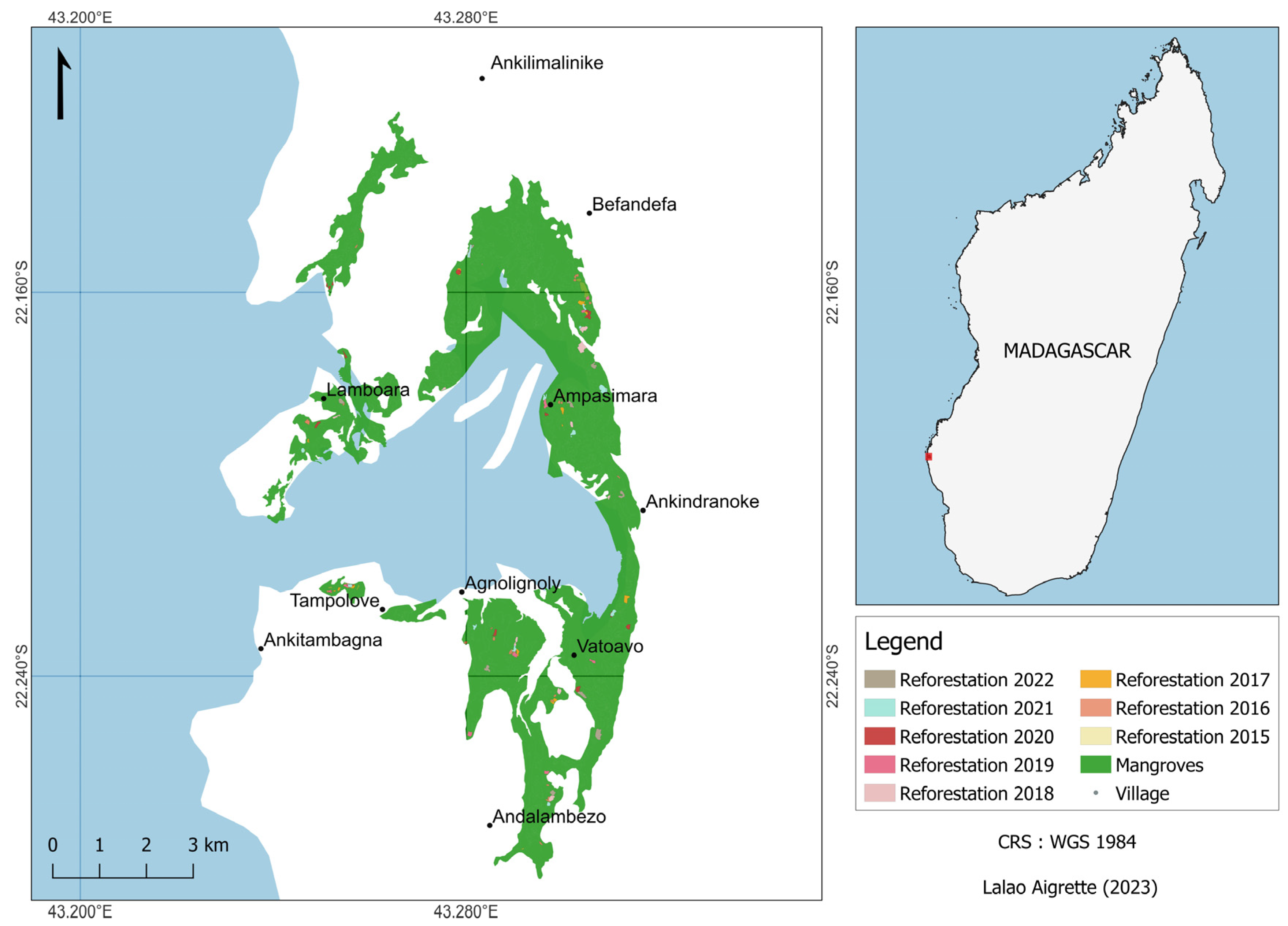
2.1. Description of the Study Site

The Baie des Assassins (BdA) is located at latitude 22″121 S, longitude 43″171 E, in the District of Morombe, the southwest region of Madagascar (Figure 1). It comprises a single bay with a comparatively modest number of mangroves, representing a contiguous ecosystem. BdA lies in the southern portion of the Velondriake Locally Managed Marine Area (LMMA). The Velondriake LMMA has 63,985 ha of surface area and is classified as a Category V protected area under the International Union for Conservation of Nature (IUCN) classification (National decree No 2015-752). The LMMA is co-managed by both Blue Ventures (BV), a Non-Governmental Organisation (NGO), and the Velondriake Association (VA).
The BdA has a semi-arid climate, and is one of the driest areas of the country, with an annual rainfall of less than 350 mm [36], and a dry season that can last 9 to 11 months [37]. The brief rainy season normally occurs between December and February. Despite the existence of two major rivers, the Mangoky and the Onilahy, along the southwest coast of the country, there is no significant river flow within a hundred km of Velondriake due to the aridity and very gradual slope inland.
The mangrove forest in the BdA covers an area of 1300 ha [38]. Seven of the eight mangrove species inventoried in Madagascar are found in the bay, Ceriops tagal and Rhizophora mucronata dominate [39]. The bay has experienced a loss of mangroves at a rate of 0.27% per year or 3.18% between 2002 and 2014 [39]. Ceriops tagal and Rhizophora mucronata were the most harvested species for uses such as; fuelwood for domestic cooking; fuel in the construction of kilns to produce lime render; building material for housing and fence construction [40,41].
BV has been supporting the VA and the community within the 10 villages across the BdA to implement Tahiry Honko, a Plan Vivo registered project. This project was designed to establish a sustainable, long-term payment for ecosystem services (PES) scheme focused on mangrove blue carbon. It is designed to earn carbon credits through the prevention of ecosystem conversion, improved land use management, and ecosystem restoration. The total carbon sequestered from these activities is estimated to be 1371 tons of CO2 equivalent per year over 20 years (2018–2037) and 830 tons of CO2 equivalent are from restoration [42]. Tahiry Honko is the first carbon sequestration project in Madagascar focused on a mangrove ecosystem.

2.2. Approach for Mangrove Restoration and Data Collection

2.2.1. Collection of Ecological Information within the Site

Due to the paucity of studies on mangrove ecology and restoration in Madagascar [43], empirical knowledge was the primary instrument used to collect the ecological information about mangroves in the study area and the site to be replanted as it can provide locally specific environmental information. The local ecological information collected through TEK includes the key identification of the mangrove propagules and peaks of availability in the area, which species previously existed in the area, and the levels of the tide, duration of inundation, as well as the level of ongoing disturbance experienced in the site to replant (Questionnaire provided in Supplementary Materials). Understanding the peak fruiting of the mangrove mother tree is important as the seasonality may vary from site to site [24], this information is also crucial in order to plan the mangrove replanting activities. Understanding the characteristics of the sites, species previously present and the range and levels of the tide, are also important to schedule the replanting session in ensuring that the right species are replanted in the area and ensuring mangrove propagules planted are frequently submerged by the tides. Understanding any ongoing disturbances can also allow further action to be taken to reduce these disturbances ahead of planting. This information was collected during the participatory mapping exercise described in the following section.

2.2.2. Identification and Mapping of Degraded Areas

  • TEK
Identification and mapping of degraded areas started through participatory mapping conducted in 2013. The process for this participatory mapping exercise is detailed at length in Rakotomahazo et al., 2019 [44]. Delineation of the zones was based on the communities’ knowledge and their traditional use. During the mapping exercise, communities from 10 villages were asked to map out areas of mangrove that they would like to put under management including degraded areas to be restored. Communities subsequently designated their mangroves into three different zones: strict conservation zone, sustainable use zone, and reforestation zone. The indicators used by communities to identify degraded areas for reforestation were largely based on community perceptions of the clear-cutting area or high density of cut stumps (e.g., more than 50% of the trees are cut), although this was not formally agreed upon during the mapping exercises, so there is likely some variation between communities in their definition of “degraded”.
  • Scientific Observations
The map containing the three different zones was digitalized in Google Earth. This mapping exercise was followed by the ground delineation and demarcation of each degraded area mapped. This delineation was carried out by a BV field technician and assisted by two or three representatives of the community who know the historical background of the mangrove areas. During the ground truthing exercise, additional information was gathered, such as the type of the soil, and species presence (where relevant). The boundaries of each site were delineated using GPS with the purpose to determine the surface and exact boundaries of those sites delineated by the local communities on the printed map during the mapping exercise. Once the participatory zoning was validated by each of the ten villages, a map of the three zones was then produced using GIS software.

2.2.3. Plantation of the Mangrove Propagules

Mangrove restoration in the BdA began in 2015. In 2016, the communities across 10 villages in the bay set an annual goal to replant 10 ha of their degraded mangrove forests [42]. Mangrove planting was scheduled by the community and was usually carried out when the propagules were abundant and mature. Further, big mangrove plantation events were organized during the celebration of International Women’s Day (8 March) and Mangrove Day (26 July) to raise awareness of the importance of mangrove restoration. The mature propagules were manually collected from the mother trees, usually a day before the plantation. The provenance of the propagules used was strictly local. The propagules were checked for quality as sometimes they were damaged by mosquitoes which may result in a lower chance of restoration success. All residents from the 10 villages (adults, youth, and school children of all genders) participated in mangrove replanting. The invitees, such as local and regional authorities, and people from outside of the village communities also participated in the mangrove replanting activity organized during the event. The species planted were Rhizophora mucronata, Ceriops tagal, and Bruguiera gymnorrizha depending on the historical background of the site and the presence of species that were present in the degraded area (identified from the ground delineation and participatory mapping). The restoration efforts were conducted through the direct planting of propagules by hand. The mangrove replanting protocol was adapted from the protocol developed by Oceanium in Senegal. The planting arrangements were random layouts, ranging from 0.5 m to 1.5 m apart and the three species were planted together. In respect of the approach proposed by the community, mangrove replanting is voluntary work but a meal, locally called rima, was offered to all participants after the replanting session as compensation given that participants could not prepare food during this day.
At each mangrove replanting session, the following information was recorded using a field sheet (see Mangrove reforestation field data record in the Supplementary Materials): the date of the plantation, name of the village, and replantation site. Each area replanted was given a different ID (name of the area (underscore) date of the plantation (dd/mm/yyyy). The total number of participants (men and women adults—above 18 years old; youth) and the number and species of mangrove propagules planted were also recorded. Since community members were recording the data the local name of the species was used. The boundary coordinates of the area replanted were also collected using a GPS device. All of this information collected was entered into Excel spreadsheets for data analysis.
A summary of the outputs of each replantation event was disseminated to each community annually and also presented to the VA during their regular meeting. The shapefile and records of each area replanted were also shared with the Ministry of Environment for national records.

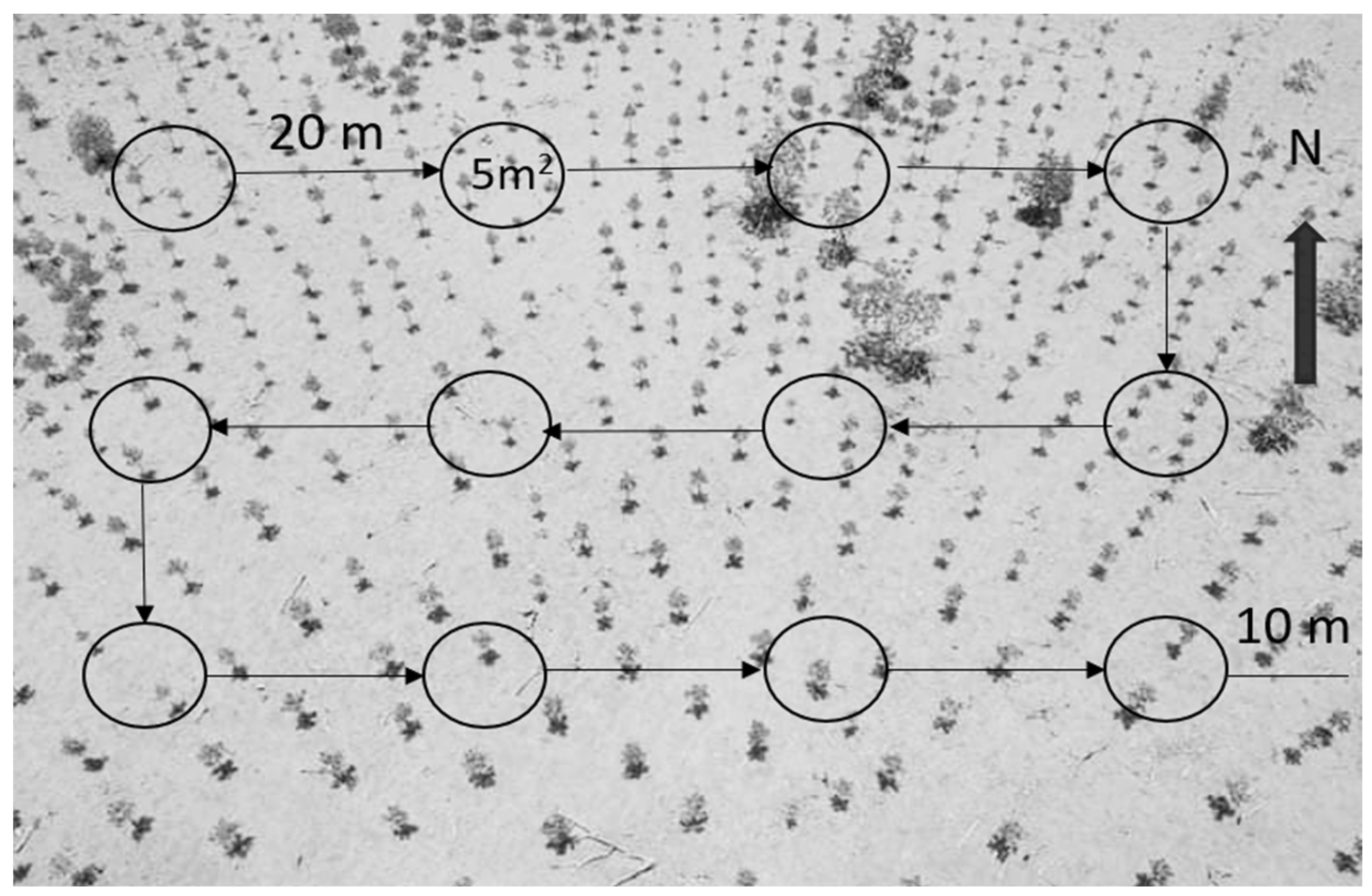
2.2.4. Monitoring the Survival Rate of Replanted Trees

While the TEK was mainly mobilized during the preparation and implementation phase, the scientific observations were applied in the monitoring and evaluation phase for feedback and adjustment to inform restoration success [24,31]. But participatory monitoring approach was used, community members were trained and assisted BV technicians in the collection of the data to assess the survival rate.
The Sampling Methods for the Tree Planting Inventory developed by the United States Department of Agriculture (USDA, Independence Avenue, SW, Washington, DC, USA) were adopted. This method is appropriate for all planting arrangements, including linear plantings, random spacing layouts, and direct seedling plantings [45]. Circular plots with a 1.26 m radius giving a plot area of 5 m2 were used. To establish the circular plots, a pole approximately 1.5 m in height was used with a 1.26 m rope attached. Twenty plots were placed per hectare giving a sampling intensity of 1% of the total area. To calculate the number of plots for the survival rate monitoring, the surface of the replanted area was multiplied by 20 (Formula (1)). The distance between each plot is 20 m apart from each other in ensuring the representativity for the method 20 plots per hectare (Figure 2). When the size of the area is less than 0.15 hectares, three plots were established, this is the minimum number recommended for the plots. When in the field, a random starting point at one corner of the reforested area was selected and the first plot was placed 10 m from the edges to avoid any edge effect. In each plot, the number of live and dead seedlings as well as their species were recorded on the field sheet (Reforestation monitoring fieldsheet can be found at the Supplementary Materials). Only the planted seedlings (Ceriops tagal, Rhizophora mucronata, and Bruguiera gymnorrizha) were monitored. The site ID (used in mangrove replanting) and date of the survey were also recorded. The monitoring of the survival rate in each replanted site was carried out first at three months and then up to three years after the plantation period. The results of the monitoring were disseminated to the community across the 10 villages, at the end of each calendar year.
Number of plots = surface of the replanted area (ha) × 20

2.3. Data Analysis

Microsoft Excel was used to store data and to run some of the basic analysis, namely, the total area replanted, the total number of trees planted, number of sites replanted (one site per replanting session), and the total number of people who participated in the mangrove replanting per year and per village, between 2015 and 2022. The total number of participants per village was calculated using the sum of participants (men and women adults, youth) at each mangrove replanting session and including the big events. The percentage of women participants was calculated by dividing the total number of women by the total number of participants.
The density of the mangrove propagules planted per hectare was calculated by dividing the total mangrove propagules planted by the total extent of the replanted area. The surface area of the replanted site was calculated using coordinates taken from the boundaries and entered into the database. The species composition was assessed using the ratio of the total tree planted by each of the species planted.
To calculate the survival rate, the following formula was used:
Surviving trees in the area replanted = (Total number of live seedlings)/(Total number of plots) × (area replanted)/(area of plot)
Survival rate (%) = (Surviving trees in the replanted area)/(Original total trees planted) × 100

2.4. Statistical Analysis

R version 4.2.2 was used to run descriptive statistics of the data. The Principal Component Analysis (PCA) was carried out for investigating the correlations between survival rate and the variables, including the number of participants, plantation density, and species composition. These three variables were set up with PCA functions to investigate the drivers influencing the survival rate. Additionally, a circle of correlation between variables was established.

3. Results

3.1. Participatory Zoning

Areas identified by communities as being “clear cut” are e zoned as reforestation areas and represented 18% (163 ha) of the total forest cover in BdA (Table 1, Figure 3). Strict conservation areas are chosen for their higher existing cover and their high value as fisheries nurseries. The sustainable user rights zone is subject to annual quotas, and identified by the communities based on the forest inventory and community requirements for timber in-house construction (including reparations) but not for commercial purposes.

3.2. Peak Availability of the Mangrove Propagules

Community members identified the peak availability of propagules in BdA as February and March for Bruguiera gymnorrhiza and Rhizophora mucronata but for Ceriops tagal, propagules are identified as being available twice a year (Table 2).

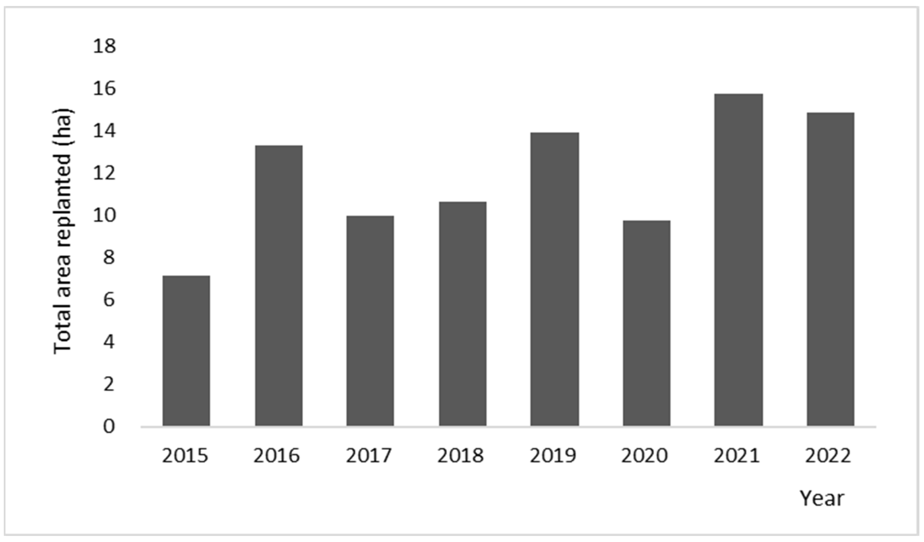
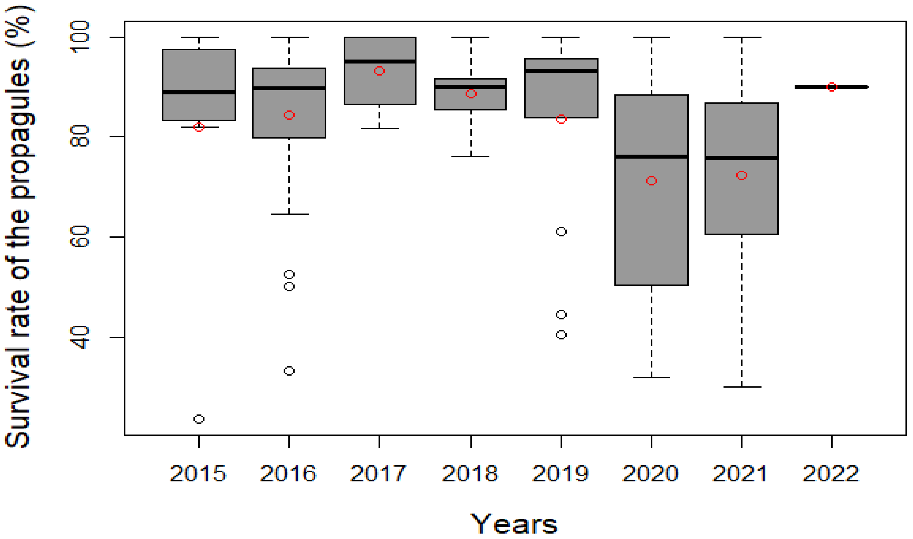
3.3. Degraded Areas Replanted and Mangrove Trees Planted between 2015 and 2022

Between 2015 to 2022, the total degraded mangrove area replanted in the BdA is 95.5 ha. As shown in Figure 4, the smallest area replanted was recorded in 2015, the first year of the mangrove replanting, and the highest area replanted was in 2021.
As summarized in Table 3, the 10 villages across the BdA have successfully replanted 440,990 mangroves propagules of three species: Ceriops tagal, Rhizophora mucronata, and Bruguiera gymnorrizha within the 95.5 ha of degraded area. This gives an average density of 4628 ± 317 mangrove propagules per hectare.
Among the 10 villages, the highest density of the mangrove propagules was recorded in Lamboara, with 6383 propagules/ha−1 and the lowest in Andalambezo, with 3225 propagules/ha−1.
The village of Befandefa accomplished the largest extent of area replanted whereas the village of Ankitambagna accomplished the smallest, 21.8 ha (21 sites) and 2.8 ha (7 sites) respectively.
Over 6000 people (adults and youth) participated in the mangrove replanting, with the highest number of participants recorded in Befandefa (1473 people) while the village of Ankitambagna has the smallest number of participants (106 people). Women represented an average of 50 percent ± 2.3 of the total participation (Table 3).

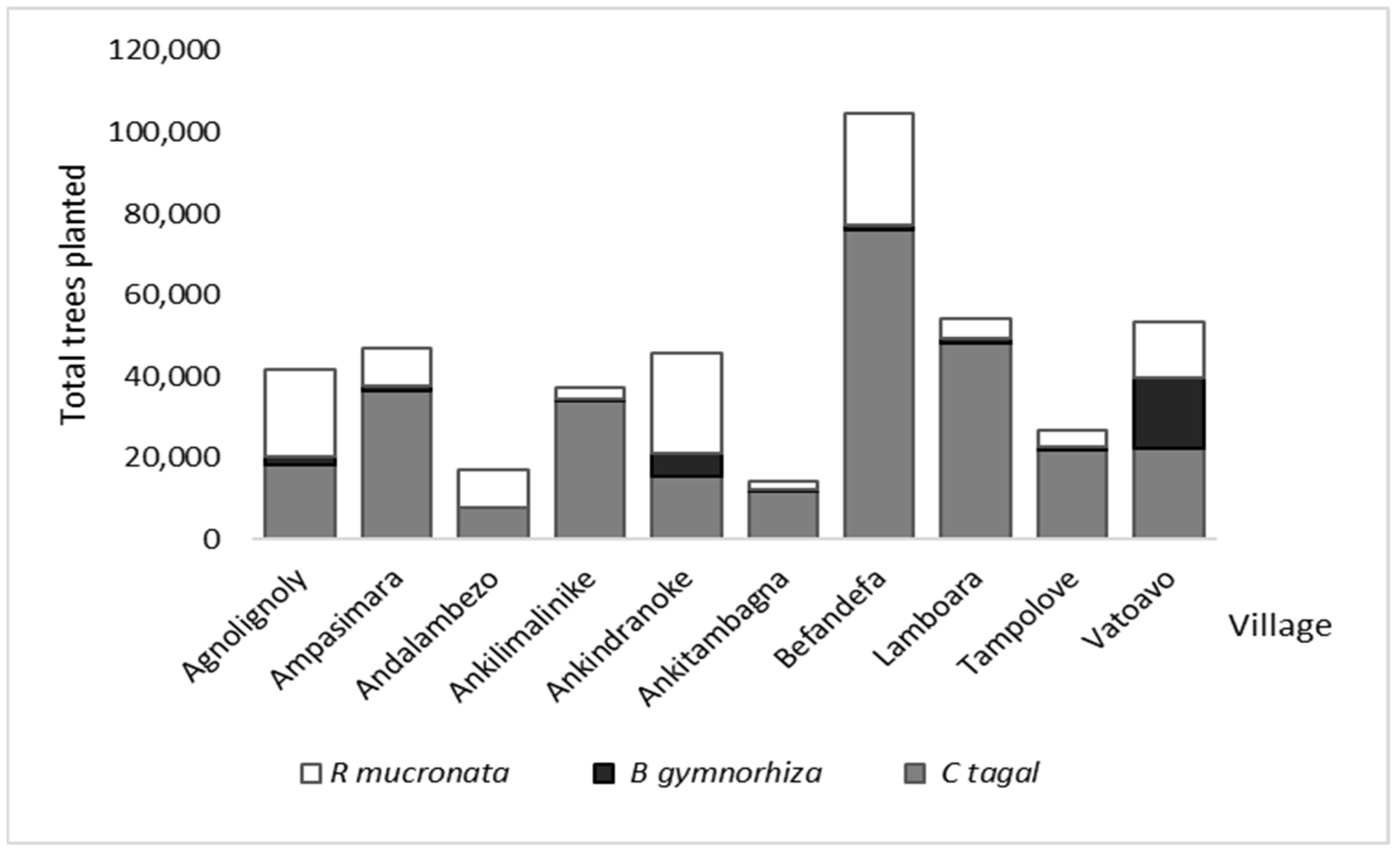
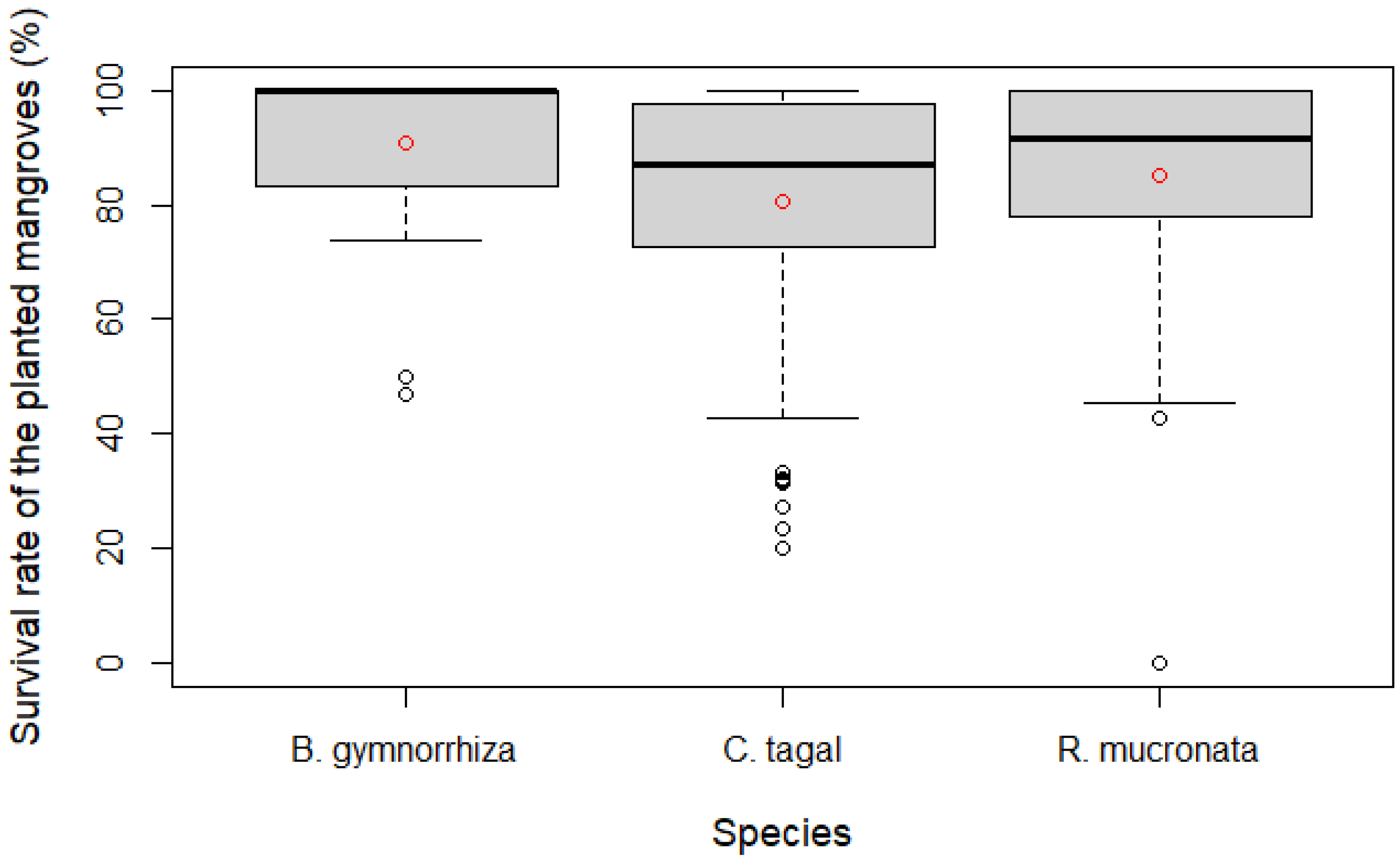
3.4. Species Composition

The dominant replanted species across the 10 villages is Ceriops tagal (66%) while Bruguiera gymnorrizha represented only 7% of the total planted propagules. The remaining 27% are Rhizophora mucronata, Bruguiera gymnorrizha is not recorded within the 5.2 ha replanted area in the village of Andalambezo (Figure 5).

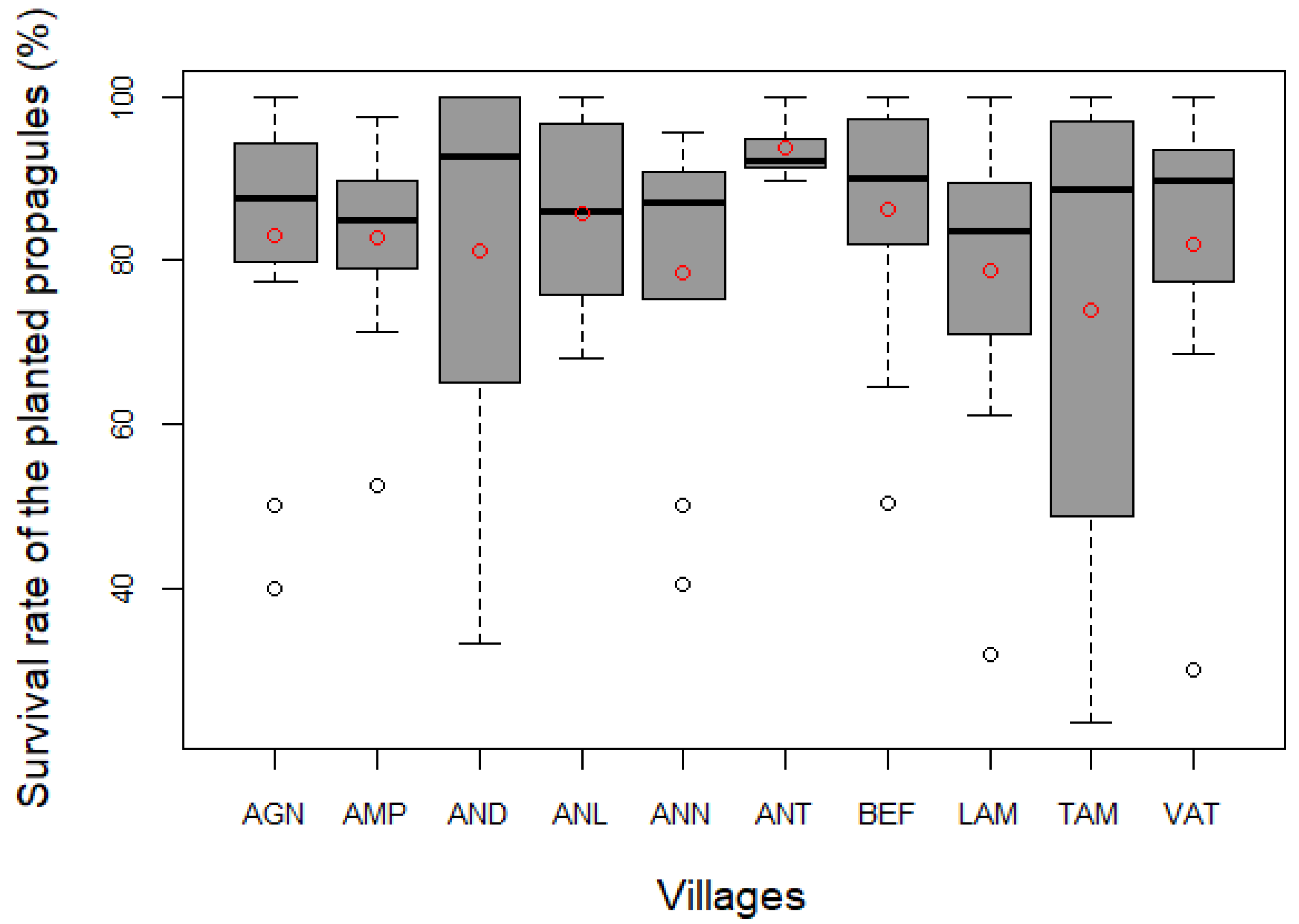
3.5. Survival Rate of the Planted Mangrove Propagules

As detailed in Table 4, the mean survival rate of the mangrove propagules planted between 2015 to 2022 within 95.5 ha across the 10 villages within the BdA was 82.5 ± 1.8%. Between the three species replanted, Bruguiera gymnorrizha had the highest survival rate, (90.7 ± 2.1%), followed by Rhizophora mucronata (85.01 ± 2.3) and then Ceriops tagal (80.5 ± 2.2%).
Of the 10 villages, Ankitambagna had the highest survival rate (93.6 ± 1.8%) and the lowest survival rate (74.0 ± 10.4%) is recorded in Tampolove (Figure 6).
The survival rate in the village with the highest planted tree density values (Lamboara) was 78.8 ± 6.4% and the survival rate in the village with the lowest planting densities (Andalambezo) was 81.1 ± 9.4%. The survival rate within the largest planted area (Befandefa) was 86.4 ± 3.3% (Figure 6; Table 4). The survival rate of the planted mangrove propagules rate in 2017 was very high (Figure 7).
Of the three species replanted, Bruguiera gymnorrizha had the highest survival rate, 90.7± 2.1%, and the Ceriops tagal was the lowest compared with Rhizophora mucronata, 80.5± 2.2% and 85.1± 2.3%, respectively (Figure 8).
The statistical analysis of the three variables, plantation density, number of participants, and species composition, was plotted against the survival rate with PCA function as stated below (Figure 9).
Axis 1 (30.21%) and Axis 2 (27.25%) represented 57.46% of the information. The analysis shows that species composition (r = 0.04; p < 0.001) and density (r = 0.04; p < 0.001) are positively correlated with survival rate. However, the number of the participants negatively correlated (r = −0.18; p < 0.001) with the survival rate (Figure 9).

4. Discussion

4.1. Mangrove Replanting

Befandefa has the largest extent of replanted trees, representing 23% (21.8 ha) of the total accomplishment (95.5 ha), 14.7 ha of which were achieved during eight mangrove replanting sessions organized to celebrate International Women’s Day (8 March) and the International Day for the Conservation of the Mangrove Ecosystem (26 July, herein World Mangrove Day). Befandefa was chosen as the venue for these events because it is the main village in the Municipality and also located in the middle of the 33 villages of the LMMA Velondriake; all were invited to attend and animate the celebration event. Moreover, Befandefa has a large extent of the degraded area. In contrast, Ankitambanga only replanted 2.8 ha, the lowest achievement; however, this village has the smallest mangrove cover compared with the other nine villages across the BdA.
Communities have committed to planting 10 hectares of mangroves per year in deforested areas zoned for reforestation in the management plan [42]. The achievement in 2021 was the highest recorded (15.8 ha), when eight villages organized mangrove replanting events in their respective villages to celebrate International Women’s Day and International Forests Day (21 March) in addition to the World Mangrove Day celebration event held in Befandefa. However, the annual goal to replant 10 ha of degraded mangroves was not reached in 2020 (9.7 ha). Due to the COVID-19 restriction, the community was not able to replant mangroves from April to September 2020 and a celebration event occurred this year. The achievement in 2015 was low (7.2 ha) because there was no annual objective fixed with the communities until 2016. Approximately, 60% of the total degraded area delineated (163 ha) was replanted
Given that awareness-building campaigns are viewed as key to reforestation success and can lead to better forest management [25], we believe that mangrove replanting events organized during the celebration of such events represent a well-suited approach not only to raise awareness to all community groups (women, men, and youth) of mangrove restoration but also to achieve the replanting goal. While women represented an average of 50 percent ± 2.3 (SEM), men and youth were proportionally represented. It is interesting to highlight that men also participated in mangrove replanting organized during International Women’s Day, representing 25% of the total participation.

4.2. Community Participation in Mangrove Replanting

In total, 6012 people (adults and youth) participated in the mangrove replanting, 22% (1307 people) of whom participated in 10 celebration events. In 2021, 62% of the participants were youth from the conservation clubs at the primary school. Women actively participated in mangrove replanting and represented 50% of the total participation. This is in line with the study undertaken on the west coast of Karnataka, India, which revealed that the percentage of fisherwomen willing to volunteer in mangrove reforestation was significantly higher compared to fishermen [46]. However, while community participation in mangrove replanting was high, not all of the community groups participated. This does not reflect refusal but rather typically reflects other factors associated with cultural roles and expectations for different members of local society. As an example, elderly people were actively involved in participatory mangrove zoning and sharing their traditional knowledge [44]; as such their direct participation in mangrove replanting was low because local culture does not permit elders to carry out strenuous outdoor work beyond fishing. We found that the continued meaningful participation of the adults and youth in mangrove replanting has positively impacted the achievement of the annual goal to replant 10 ha.
While studies carried out in Sine-Saloum Delta revealed that financial incentives from international organizations and NGOs are significant in motivating community involvement in mangrove restoration [27], our results showed that in BdA, all of the communities meaningfully participated in mangrove replanting without payment. Even though a study carried out in Uganda argued that anticipated carbon payments seemed to influence community participation [47], we believe that in BdA, the approach to provide a meal, rima, recommended by the community given to the participants after the mangrove replanting session was the primary driving force of community motivation. Given that men might not be able to go fishing and women cannot prepare food for their families during a replanting day, they may not voluntarily replant mangroves without a meal in compensation. Although the social norms in BdA often considered mangrove replanting as a women’s duty, this approach has positively attracted the participation of men. But, it is important to note that the community plans the replanting together with Blue Ventures thus ensuring that the schedule works for the majority.
Despite community participation being viewed as a key to success in ecosystem restoration [21,22], our results showed that the number of participants is negatively correlated with the survival rate. This is in line with the evidence reported from Senegal, where a large number of people participated in mangrove replanting and the survival rate was very low. It was suggested that this may have been due to the monetary incentives from NGOs [27]. Our results confirm a negative correlation between the number of participants and the survival rate, however, since the activity was not paid in BdA this may be due to other reasons. One observation is that when there is a high number of participants, there is a higher risk that replanting protocols are not well respected, and it is arguable that with smaller groups all the planters could be more proficiently trained and motivated, thus increasing the success rate; alternatively, increasing training capacity for larger groups may have a similar effect. Limiting the number of participants may produce harmful effects on community motivation given that mangrove replanting is voluntary and unpaid work in BdA. Additionally, the quality of propagules may be less controlled in big mangrove replanting events; we strongly recommend that the quality of the propagules to be planted must be monitored. While propagules can be stored in cool wet conditions for 10–30 days [24], good propagules should be sorted a day before the actual replanting to save time and to ensure that appropriate sorting keys are respected. It was observed during a big mangrove event organized by partners outside of our study site that one of the factors resulting in the mangrove restoration failure was the planting of immature and/or bitten propagules. As they were purchased (per piece/buckets/baskets), the people collecting/selling them considered the quantity but not the quality to earn more money. In this case, it would be worth considering financially compensating people or investing the time of the participants to quality check the propagules before the replanting to ensure a greater likelihood of successful restoration. In BdA, propagules were not purchased, invitees from villages were asked to bring selected propagules from their respective villages when big events is being organized. While technical assistance and training are reported as key to reforestation success, we suggest that for a large number of participants, especially when invitees are not familiar with the replanting techniques, participants must be fully briefed on the sowing techniques before the replanting activity. Participants should subdivide into small groups. The ideal number is 38 people per hectare, referring to the participants per hectare recorded in Ankitambagna. Each group should be assisted by a trained technician (these would be ideally locally recruited and trained) to ensure that propagules are correctly sowed, e.g., not upside down. We found that regular awareness raising and briefing about the replanting protocol carried out by a technician before replanting events was vital and has positively contributed to the success of the mangrove restoration in the BdA when organizing big replanting events. A short video was subsequently produced showing the key identification of ripe propagules, selecting good propagules, and plant spacing. This also helped the community assimilate with the protocol. We believe that this is a well-suited educational material adapted to the local context as there were no dialect and language barriers because the video was produced with the youth from the BdA.
From a land tenure perspective, since BdA is located within a gazetted marine protected area (National decree No 2015-752), the area has stable land tenure. Both private and customary property rights and land were mapped during the participatory mapping, and overlap issues were also resolved during the validation workshop of the mangrove zoning gathered community representatives of each village and assisted by chef Fokontany, head of the smallest administrative division [44], the risk of conflict over land is relatively low. In addition, the 10 villages agreed on a set of rules to regulate resource use and prevent conflict among mangrove users.

4.3. Density of Mangrove Replanting

The overall density of the plantation in BdA, 4628 ± 317 propagules per hectare, surpassed the highest density recorded within the undisturbed tall, mature stands and canopy > 80% closed, Ceriops tagal dominated mangrove in the bay, 3927 ± 244 stem per hectare [39]. Similarly, this density was higher compared with the density of the mixed species stands in both Ambaro-Ambaja and Mahajamba’ bays, 1108 ± 208 and 1825 ± 248 trees/ha−1 respectively [38,48]. Also higher compared with the stand density of mangroves in Ngomeni, Kenya, with 1688 stems per hectare for Rhizophora mucronata dominated and 2367 stems per hectare for Ceriops tagal dominated [49]. However, the density of the plantation in the BdA was lower compared with the highest number of trees per hectare recorded within the tall, mature stands of trees Rhizophora mucronata dominated, recorded in Mahajamba, 4900 ± 1500 trees/ha−1 [48], and within the highest density recorded within intact, tall and mature stands dominated by Rhizophora mucronata recorded in Ambaro-Ambanja bays, 4719 ± 1133 trees/ha−1 [38]. Additionally, this is lower compared with the highest density of mature trees recorded on the eastern coast of Madagascar, 7960 tree/ha−1 [50].
Our results showed that the density of planted mangroves is positively correlated with the survival rate. Even though greater plant spacing was associated with high survival of stilt-rooted species in the family Rhizophoraceae [24,51], we found that it is important to consider the reference forest in the vicinity to ensure that the restored site has achieved an adequate stem density. Although the density of the plantation surpassed the highest density recorded within the mangrove forests in the bay [39], with the average survival rate (82.5 ± 1.8%), we expected that the density of mature stands within the restored forests can reach 3816 ± 278 stem/ha−1 which closely aligned with the undisturbed forests in the bay. From our finding, we suggested that for plantations dominated by Ceriops tagal, the density should range from 3250 to 4800 mangrove propagules per hectare to reach either the density of the undisturbed tall, mature stands (3927 ± 244 stem/ha−1) or the short-medium trees (2653 ± 343 stem/ha−1), Ceriops tagal dominated mangrove in the reference forests [39]. The density should range from 2300 to 4300 mangrove propagules to reach either the Rhizophora mucronata dominated for tall and mature stands (3564 ± 478 stem per hectare) or the short-medium trees (1800 ± 600 stem per hectare) [39]. We suggest that in BdA, the density of the mangrove planting both stilt- and knee-rooted species including, Ceriops tagal, Rhizophora mucronata, and Bruguiera gymnorrhiza, should be between 2300 to 4800 mangrove propagules per hectare, depending on species composition and dominance. We believe that this density can be used for the other sites in Madagascar or in different countries with similar environmental conditions.

4.4. Survival Rate of the Replanted Mangrove

Tampolove had the lowest survival rate of 74 ± 10.4%; the community confirmed that the mortality was mainly due to livestock grazing (goats and cattle) as the restoration sites are located in nearby villages. This is reported as a common cause of reforestation failure, especially in the tropics [52]. In contrast, the highest survival rate was recorded in Ankitambagna: 93.6 ± 1.8%. It is likely that the number of participants, 15 people per session on average, can explain this given that the number of participants is negatively correlated with the survival rate. Furthermore, 80% of the participants were adults and the replanting protocol is correctly respected. Even assuming that adults are better than youth, we believe that involving youth is a well-suited approach not only to achieve the annual set goal but also to raise their awareness of mangrove restoration as future mangrove users. However, technical assistance must be provided by a technician to ensure that protocols are fully respected.
The survival rate in 2017 was very high, the season of the plantation may explain this given that climate was correlated with the survival of planted both stilt- and knee-rooted species [51]. The climate of the west coast of Madagascar is dependent on the Inter-Tropical Zone of Convergence movement. The lowest temperature, around 20–25 °C, appears during the southwest monsoon in July, August, and September [53]. Our records showed that 55% of the planting in 2017 occurred in June-Sept when the temperature is lower. Given that the southwest is semi-arid and there is no river flow within the BdA, this period appeared the most suitable for planting mangroves. Based on the same assumption, the survival rate in 2020 was the lowest because, due to the first COVID-19 lockdown in the country, all of the planting this year occurred in February–March and October–December.
Our results show that the overall survival rate of planted mangroves in the BdA, dominated by Ceriops tagal was 82.5 ± 1.8%. This rate was slightly lower when compared to the survival rate reported in Gazi Bay, Kenya which was 86.2% for the Ceriops tagal [54]. Despite the overall survival rate of the planted mangroves in the BdA being slightly lower compared with Gazi Bay, Kenya, the survival rate of Bruguiera gymnorrizha was 90.7± 2.1%. This was very high compared with the planted Bruguiera gymnorrhiza in Rufiji Delta, Tanzania, estimated at 37% [55] and 28% in Gazi Bay, Kenya [54]. Given that the propagules of Bruguiera gymnorrhiza were naturally the smallest in number compared with the other two species, it may be that the number of propagules collected also influences the rate of survival. While good propagules were sorted out before the actual planting, it is highly probable that, due to the low number, Bruguiera gymnorrizha were correctly sorted according to the appropriate sorting keys.
The mangrove restoration in BdA can be considered as successful as the overall survival rate surpassed the 60% target survival rate identified by Tomlinson [56] and the species composition and community structure are also more closely aligned with the reference site [31]. The low level of disturbance due to the selective cutting of mangrove wood in the BdA [40] can explain this success. Additionally, while the propagule sourcing was strict local provenancing, the risk of maladaptation of the planted trees is very low because their parents are adapted to similar conditions [31]. However, even though propagules were collected locally, community members perceived that there were significant distances from mature trees as a result of the forest disturbance.
While planting the wrong species in the wrong places and planting in areas that were not previously occupied by mangroves were viewed as recurring factors of mangrove restoration failure [20,23], we found that mobilizing TEK in mapping and collecting ecological information of the site to be replanted was crucial in order to avoid mistakes being repeated in planting species not adapted to the site. Furthermore, in some cases, the choice of species of mangrove that is planted during reforestation events was influenced by the supporting organization or village Chief, when mangroves are heavily degraded and propagules are collected from far away [27]. In BdA, the species to be planted was chosen by the community based on their traditional ecological knowledge. The dominant species being planted was Ceriops tagal (66%) while Bruguiera gymnorrizha represented only 7%, which is in line with natural species distribution in undisturbed forests reported in Benson (2017) [39].
While better hydrological connection with good tidal flushing and drainage significantly improved restoration project outcomes [28], the community in the BdA usually scheduled mangrove replanting during spring tide in ensuring that the replanted area would have tidal inundation by daily tides following plantation. The tidal range on the southwest coast of Madagascar can reach up to 4.75 m [53]. TEK presented its strength to provide reliable information on the duration of inundation for the site to be replanted. The community confirmed that mangrove forest degradation in the bay was so recent and has no significant damage to hydro sedimentologic conditions and tidal flows which bring sediment, and nutrients. Even though that degraded and fragmented mangrove landscapes are likely the easiest to restore as the hydrological processes and species characteristics are still present [57], we found that TEK played a key role in selecting appropriate sites, choosing the right mangrove species, and scheduling the planting period.

4.5. Restoration Technique

Both the restoration approach, passive and active, were applied in the BdA through the mangrove management plan and participatory zoning established by the communities. The strict protection zone and sustainable zone, represented 82% of the total forest cover, intended to support passive restoration while artificial regeneration is done through direct planting within the remaining degraded areas. The mangroves were zoned based on local knowledge [44], the Dina, local regulation established by communities governing the use of mangroves is intended to remove further ecosystem stressors as mangrove harvesting is strictly prohibited in the strict conservation zones, and harvesting mangrove timber for lime production is controlled in the sustainable use zone [42].
Even though some studies concluded that degraded mangrove areas may recover naturally [21,22], information and knowledge about the degree of natural regeneration and the ability of a clear-cut recover in the BdA are unavailable. Moreover, the natural regeneration of disturbed mangrove forests by logging is questionable [22]. Despite communities in the BdA having confirmed that natural regeneration occurred in some of the degraded areas, natural replacement may not be of the same species removed and less control over spacing [22]. Thus, the direct plantation was the approach chosen to restore the degraded area in the BdA. This is viewed as an efficient strategy for areas subjected to disturbance as the plantation of tree species can catalyze forest succession, improving soil fertility and restoring ecological interactions [58]. Moreover, where mangroves are degraded rather than lost, they present an opportunity for rapid and effective intervention as local conditions remain suitable [58]. We believe that for BdA, replacing harvested trees through direct planting is a well-suited intervention to restore degraded mangroves after human disturbance where the hydro sedimentologic conditions are unaltered. While Rhizophora mucronata, Ceriops tagal, and Bruguiera.gymnorrizha, were the most targeted species for lime production [41], they constituted the species that previously existed in the degraded area. Direct planting of propagules by hand was adopted as a commonly approach applied for mangroves belonging to the Rhizophoraceae family [24]. Even though that different planting techniques can be used, previous experiences confirmed that direct planting of propagules is three times less expensive than using nursery-raised saplings [22]. We believe that the direct planting of propagules is relevant, especially in arid regions such as the BdA, where freshwater supplies are more limited compared to higher-productivity systems.

4.6. TEK and Scientific Observations to Support Mangrove Restoration

TEK plays a vital role by providing signs of ecosystem change and has a strong potential for informing the science of ecological restoration [32]. However, even though that TEK provided reliable locally specific ecological information about mangroves in the reference forests and the site to be replanted in the BdA, it has limitations in the monitoring and evaluation phase because mangrove restoration is quite a young discipline. Mangrove restoration through direct planting of propagules have been initiated in Madagascar in 2009, but this initiative began in the BdA in 2015. The monitoring and evaluation phase is crucial in any restoration initiative for feedback and adjustment to inform restoration success [24,31]. Studies revealed that the time interval used to evaluate success is about 1–15 years [59]. In this context, TEK and science can be seen as having complementary perspectives because indigenous knowledge, while it may produce important knowledge, does not do so in the ways that scientific disciplines do [32]. While TEK refers to knowledge mobilization to gather bioecological information to guide mangrove replanting initiatives in the BdA, scientific observations helped formulate research methods, questions, and hypotheses to understand the factors influencing the survival rate of planted mangrove trees.
Although the remoteness of the BdA has a positive impact on mangrove preservation in the bay, the growth of sokay production, a sea-shell-based lime produced in mangrove wood kilns, over the previous decades resulting in clear cutting of mangrove forest [40]. Thus, mangrove management plans and zoning constituted a strategy adopted by the community to revert these trends and promote sustainable management of forests and fisheries they support. Delineation of the zone and development of rules governing each zones were based on the communities’ knowledge and traditional uses [44] but scientific knowledge was mobilized in estimating the quota for sustainable use based on inventory and domestic use of mangrove wood. Additionally, scientific knowledge was applied to refine the participatory zoning using GIS software when the map of three zones was validated by each of the ten villages.
Despite the importance of TEK in ecosystem restoration, a number of case studies from across the planet have provided evidence of its rapid degradation in recent decades [59]. Environmental degradation is reported as factor driving change and classified as direct threat to TEK [60]. A wide variety of actions in response to threats is therefore crucial to conserve and revitalize TEK. Besides the treaties and agreements for the protection of indigenous rights and TEK conservation, such as UNDRIP and CBD, we suggest that local capacity in the new discipline, such as mangrove replanting, and mangrove carbon stock assessment, should be reinforced. As TEK holders, the local community should be involved in ecological monitoring (forest inventory, survival rate, etc.) and outcomes must be disseminated/presented in a format appropriate to the community to revitalize their knowledge. It would also be useful to look into how traditional knowledge may be strengthened through further engagement in activities such as replantation.

4.7. Limitations of the Methods and Study

Although we found diverse advantages in using the TEK and sciences observations to inform successful mangrove restoration, we encountered some limitations in practice. While there is a vast body of literature comparing scientific observations and traditional knowledge in natural resources management, including mangrove [35,61], it is not well documented for the case of mangrove restoration. This study presents, for the first time, the investigation of factors driving mangrove restoration success in Madagascar. However, in practice, the study used both TEK and scientific observations. However, providing a more robust comparison of the TEK and scientific approaches would require a comparison between some sites only applying TEK, at some sites only applying scientific observations and some sites with both. Separating the contribution of TEK was therefore a limitation of this study. Also, there is no difference in methods applied at the sites. At all sites, the same community consultations, training, collecting propagules, and planting were the same and so further comparison of approaches/methods was not possible.

5. Conclusions

Communities are actively involved in mangrove management in the BdA and taking a leading role from the initial stage in developing the mangrove management plan. They are committed to preserving the current quality and extent of their mangrove and restoring the degraded forests. This paper highlights that TEK and outside technical expertise are both vital to inform successful restoration. They are complementary and can learn from each other. Despite the extensive knowledge of the community about their mangrove, the complexity of factors influencing restoration success and failure necessitates different forms of knowledge. However, this is the first study investigating the drivers of mangrove restoration success in Madagascar and only focused on the survival rate of planted mangroves. The main result from this research indicated that having large numbers of people involved in replanting events may affect the subsequent survival rate. However, although we were not able to identify the primary driver of this negative relationship it is important to highlight that future research may be able to focus on identifying if this is indeed due to the effects of replanting or if it is likely due to other factors (such as ongoing threats/stresses not being addressed effectively) and thus further research might explore other socio-ecological factors and long-term monitoring of impact indicators such as key stressors, as well as further biological variables such as tree increment and fish biomass in mangroves. It would also be useful to look into how using different types of knowledge could be carried out not only to answer some specific questions but also to build the capacity of TEK holders.

Supplementary Materials

The following supporting information can be downloaded at: https://www.mdpi.com/article/10.3390/f14071368/s1. Supplementary file: Questionnaire for the Participatory mapping; Mangrove reforestation field data record; Reforestation monitoring fieldsheet.

Author Contributions

L.A.R. led the conceptualization of the study, produced the map for the sites, and wrote the manuscript; C.R. supervised the data collection and ensured the database management also editing of the manuscript; C.A. led the mangrove replanting and monitoring of the survival rate and ensured the data collection; I.R. carried out the data and statistical analysis including interpretation; L.G. contributed to manuscript edits and produced the map for the mangrove zoning; L.R. and T.L. ensured the academic supervision and provided technical recommendations to the study. All authors have read and agreed to the published version of the manuscript.

Funding

This research has been supported by the UK government’s International Climate Finance (ICF) and Darwin Initiative, the Global Environment Facility (GEF, Funding Code: GFL-5060-2730-Mnnn), and the MacArthur Foundation (Funding Code: 18-1804-152992-CSD). The ICF refers to UK aid support given to poorer countries to help them deal with the causes of climate change, through actions such as protecting forests and mangroves, which act as vital carbon sinks, and restoring degraded ecosystems.

Acknowledgments

The author would like to thank Holly Elgar, Jennifer Hacking, and Charlie Gough for providing their input and recommendation on this manuscript. Additional thanks also go to Patrick Rafidimanantsoa for providing invaluable technical support to improve the mangrove replanting database system. Finally, we acknowledged all of the community members across the 10 villages in the Baie des Assassins for sharing with us their precious knowledge about their mangroves.

Conflicts of Interest

The authors declare no conflict of interest.

References

  1. Salem, M.E.; Mercer, D.E. The economic value of mangroves: A meta-analysis. Sustainability 2012, 4, 359–383. [Google Scholar] [CrossRef] [Green Version]
  2. Walters, B.B.; Rönnbäck, P.; Kovacs, J.M.; Crona, B.; Hussain, S.A.; Badola, R.; Primavetra, J.H.; Balrbier, E.; Dahdouh-Guebas, F. Ethnobiology, socio-economics and management of mangrove forests: A review. Aquat. Bot. 2008, 89, 220–236. [Google Scholar] [CrossRef] [Green Version]
  3. Millennium Ecosystem Assessment. Ecosystems and Human Well-being: Synthesis; Island Press: Washington, DC, USA, 2005. [Google Scholar]
  4. Barbier, E.B. Valuing the storm protection service of estuarine and coastal ecosystems. Ecosyst. Serv. 2015, 11, 32–38. [Google Scholar] [CrossRef]
  5. Barbier, E.B.; Hacker, S.D.; Kennedy, C.; Koch, E.W.; Stier, A.C.; Silliman, B.R. The value of estuarine and coastal ecosystem services. Ecol. Monogr. 2011, 81, 169–193. [Google Scholar] [CrossRef]
  6. Lee, S.Y.; Primavera, J.H.; Dahdouh-Guebas, F.; McKee, K.; Bosire, J.O.; Cannicci, S.; Diele, K.; Fromard, F.; Koedam, N.; Marchand, C.; et al. Ecological role and services of tropical mangrove ecosystems: A reassessment. Glob. Ecol. Biogeogr. 2014, 23, 726–743. [Google Scholar] [CrossRef]
  7. Donato, D.C.; Kauffman, J.B.; Mackenzie, R.A.; Ainsworth, A.; Pfleeger, A.Z. Whole-island carbon stocks in the tropical Pacific: Implications for mangrove conservation and upland restoration. J. Environ. Manag. 2012, 97, 89–96. [Google Scholar] [CrossRef]
  8. Donato, D.C.; Kauffman, J.B.; Murdiyarso, D.; Kurnianto, S.; Stidham, M.; Kanninen, M. Mangroves among the most carbon-rich forests in the tropics. Nat. Geosci. 2011, 4, 293–297. [Google Scholar] [CrossRef]
  9. Taillardat, P.; Friess, D.A.; Lupascu, M. Mangrove blue carbon strategies for climate change mitigation are most effective at the national scale. Biol. Lett. 2018, 14, 20180251. [Google Scholar] [CrossRef] [Green Version]
  10. FAO. Global Forest Resources Assessment; Food and Agriculture Organization of the United Nations: Rome, Italy, 2020. [Google Scholar]
  11. Malik, A.; Fensholt, R.; Mertz, O. Mangrove exploitation effects on biodiversity and ecosystem services. Biodivers. Conserv. 2015, 24, 3543–3557. [Google Scholar] [CrossRef]
  12. Clausen, A.; Rakotondrazafy, H.; Ralison, H.O.; Andriamanalina, A. Mangrove Ecosystems in Western Madagascar: An Analysis of Vulnerability to Climate Change. Study Report, WWF Madagascar. 2010. Available online: http://awsassets.panda.org/downloads/wwf_mangrov_a4_cc_va.pdf (accessed on 25 June 2023).
  13. Hamilton, S.E.; Friess, D.A. Global carbon stocks and potential emissions due to mangrove deforestation from 2000 to 2012. Nat. Clim. Chang. 2018, 8, 240–244. [Google Scholar] [CrossRef] [Green Version]
  14. Pendleton, L.; Donato, D.C.; Murray, B.C.; Crooks, S.; Jenkins, W.A.; Sifleet, S.; Craft, C.; Fourqurean, J.W.; Kauffman, J.B.; Marbà, N.; et al. Estimating Global ‘Blue Carbon’ Emissions from Conversion and Degradation of Vegetated Coastal Ecosystems. PLoS ONE 2012, 7, e43542. [Google Scholar] [CrossRef] [Green Version]
  15. United Nations Decade on Ecosystem Restoration (2021–2030). Resolution 73/284, Adopted by the General Assembly on 1 March 2019. Available online: https://undocs.org/Home/Mobile?FinalSymbol=A%2FRES%2F73%2F284&Language=E&DeviceType=Desktop&LangRequested=False (accessed on 25 June 2023).
  16. Ellison, A.M. Mangrove Restoration: Do We Know Enough? Restor. Ecol. 2000, 8, 219–229. [Google Scholar] [CrossRef]
  17. Ellison, A.M.; Felson, A.J.; Friess, D.A. Mangrove Rehabilitation and Restoration as Experimental Adaptive Management. Front. Mar. Sci. 2020, 7, 327. [Google Scholar] [CrossRef]
  18. Macreadie, P.; Nielsen, D.A.; Kelleway, J.; Atwood, T.B.; Seymour, J.R.; Petrou, K.; Connolly, R.M.; Thomson, A.; Trevathan-Tackett, S.M.; Ralph, P. Can we manage coastal ecosystems to sequester more blue carbon? Front. Ecol. Environ. 2017, 15, 206–213. [Google Scholar] [CrossRef] [Green Version]
  19. Hutchison, J.; Spalding, M.D.; Zu Ermgassen, P.S.E. The Role of Mangroves in Fisheries Enhancement. The Nature Conservancy and Wetlands International. 2012; 54p. Available online: https://www.oieau.fr/eaudoc/system/files/33226.pdf (accessed on 25 June 2023).
  20. Lewis, R.; Lewis, E.; Lewis, R.R., III. Chapter 28—Methods and Criteria for Successful Mangrove Forest Restoration; Coastal Resources Group, Inc.: Salt Springs, FL, USA, 2009; Available online: https://www.researchgate.net/publication/292718083 (accessed on 25 June 2023).
  21. Holl, K.D.; Aide, T.M. When and where to actively restore ecosystems? For. Ecol. Manag. 2011, 261, 1558–1563. [Google Scholar] [CrossRef]
  22. Kairo, J.G.; Dahdouh-Guebas, F.; Bosire, J.; Koedam, N. Restoration and management of mangrove systems—A lesson for and from the East African region. S. Afr. J. Bot. 2001, 67, 383–389. [Google Scholar] [CrossRef] [Green Version]
  23. Bosire, J.O.; Dahdouh-Guebas, F.; Walton, M.; Crona, B.; Lewis, R.; Field, C.; Kairo, J.; Koedam, N. Functionality of restored mangroves: A review. Aquat. Bot. 2008, 89, 251–259. [Google Scholar] [CrossRef] [Green Version]
  24. UNEP-Nairobi Convention/USAID/WIOMSA. Guidelines on Mangrove Ecosystem Restoration for the Western Indian Ocean Region 2020; UNEP: Nairobi, Kenya, 2020; 71p, Available online: www.wiomsa.org (accessed on 25 June 2023).
  25. Le, H.D.; Smith, C.; Herbohn, J. What drives the success of reforestation projects in tropical developing countries? The case of the Philippines. Glob. Environ. Chang. 2014, 24, 334–348. [Google Scholar] [CrossRef]
  26. Spalding, M.D.; Leal, M. The State of Mangroves P16-35 The Benefits of Mangroves P36-51 1. Available online: https://www.mangrovealliance.org/; www.globalmangrovewatch.org (accessed on 25 June 2023).
  27. Gallup, L.; Sonnenfeld, D.A.; Dahdouh-Guebas, F. Mangrove use and management within the Sine-Saloum Delta, Senegal. Ocean Coast. Manag. 2020, 185, 105001. [Google Scholar] [CrossRef] [Green Version]
  28. Wodehouse, D.C.J.; Rayment, M.B. Mangrove area and propagule number planting targets produce sub-optimal rehabilitation and afforestation outcomes. Estuar. Coast. Shelf Sci. 2019, 222, 91–102. [Google Scholar] [CrossRef] [Green Version]
  29. Le, H.D.; Smith, C.; Herbohn, J.; Harrison, S. More than just trees: Assessing reforestation success in tropical developing countries. J. Rural. Stud. 2012, 28, 5–19. [Google Scholar] [CrossRef] [Green Version]
  30. Martin, D.M. Ecological restoration should be redefined for the twenty-first century. Restor. Ecol. 2017, 25, 668–673. [Google Scholar] [CrossRef] [PubMed] [Green Version]
  31. Gann, G.D.; McDonald, T.; Walder, B.; Aronson, J.; Nelson, C.R.; Jonson, J.; Hallett, J.G.; Eisenberg, C.; Guariguata, M.R.; Liu, J.; et al. International principles and standards for the practice of ecological restoration. Second edition. Restor. Ecol. 2016, 27, S1–S46. [Google Scholar] [CrossRef] [Green Version]
  32. Kimmerer Robin Wall. Weaving Traditional Ecological Knowledge into Biological Education: A Call to Action. BioScience 2002, 52, 432–438. [Google Scholar] [CrossRef] [Green Version]
  33. United Nations Declaration on the Rights of Indigenous Peoples United Nations. UN Office of the High Commissioner for Human Rights (OHCHR), August 2013, HR/PUB/13/2. Available online: https://www.refworld.org/docid/5289e4fc4.html (accessed on 25 June 2023).
  34. Zedler, J.B.; Stevens, M.L. Western and traditional ecological knowledge in ecocultural restoration. San Francisco Estuary Watershed Sci. 2018, 16. [Google Scholar] [CrossRef] [Green Version]
  35. Inglis, J. Traditional Ecological Knowledge in perspectives. Traditional Ecological Knowledge: Concepts and Cases. International Program on Traditional Ecological Knowledge, Canada Museum of Nature, and International Development Research Centre, Canada. 1993. Available online: https://idrc-crdi.ca/en/book/traditional-ecological-knowledge-concepts-and-cases (accessed on 25 June 2023).
  36. Ministere de la Meteorologie. Direction Générale de la Météorologie, CPGU, Banque Mondiale et RIMES, 2019. Les Tendances Climatiques et les Futurs Changements Climatiques à Madagascar—2019. Available online: https://www.resiliencemada.gov.mg/showmetadata/xsl/593 (accessed on 25 June 2023).
  37. Langley, J.M. Vezo Knowledge: Traditional Ecological Knowledge in Andavadoaka, Southwest Madagascar. Blue Ventures Conservation Report. 2006. Available online: https://blueventures.org/publications/the-2004-2005-census-of-andavadoaka-southwest-madagascar/ (accessed on 25 June 2023).
  38. Jones, T.G.; Glass, L.; Gandhi, S.; Ravaoarinorotsihoarana, L.; Carro, A.; Benson, L.; Ratsimba, H.R.; Giri, C.; Randriamanatena, D.; Cripps, G. Madagascar’s mangroves: Quantifying nation-wide and ecosystem specific dynamics, and detailed contemporary mapping of distinct ecosystems. Remote Sens. 2016, 8, 106. [Google Scholar] [CrossRef] [Green Version]
  39. Benson, L.; Glass, L.; Jones, T.G.; Ravaoarinorotsihoarana, L.; Rakotomahazo, C. Mangrove carbon stocks and ecosystem cover dynamics in southwest Madagascar and the implications for local management. Forests 2017, 8, 190. [Google Scholar] [CrossRef] [Green Version]
  40. Scales, I.R.; Friess, D.A. Patterns of mangrove forest disturbance and biomass removal due to small-scale harvesting in southwestern Madagascar. Wetl. Ecol. Manag. 2019, 27, 609–625. [Google Scholar] [CrossRef] [Green Version]
  41. Scales, I.R.; Friess, D.A.; Glass, L.; Ravaoarinorotsihoarana, L. Rural livelihoods and mangrove degradation in south-west Madagascar: Lime production as an emerging threat. ORYX 2017, 52, 641–645. [Google Scholar] [CrossRef] [Green Version]
  42. Project Design Document: Tahiry Honko Community Mangrove Project, Southwest Madagascar. 2019. Available online: https://www.planvivo.org/Handlers/Download.ashx?IDMF=39070798-4292-4797-9ab2-7db77a9afe63 (accessed on 25 June 2023).
  43. Ministère de l’Environnement et du Développement Durable et Ministère de l’Agriculture, de l’Elevage et de la Pêche; Etat des lieux des Mangroves de Madagascar: Antananarivo, Madagascar, 2019; 208p.
  44. Rakotomahazo, C.; Ravaoarinorotsihoarana, L.A.; Randrianandrasaziky, D.; Glass, L.; Gough, C.; Todinanahary, G.G.B.; Gardner, C.J. Participatory planning of a community-based payments for ecosystem services initiative in Madagascar’s mangroves. Ocean Coast. Manag. 2019, 175, 43–52. [Google Scholar] [CrossRef]
  45. Department of Agriculture and, N. Resources Conservation Service, Title 190-Forestry Inventory Methods Technical Note Forestry Inventory Methods. 2018. Available online: www.ascr.usda.gov (accessed on 25 June 2023).
  46. Stone, K.; Bhat, M.; Bhatta, R.; Mathews, A. Factors influencing community participation in mangroves restoration: A contingent valuation analysis. Ocean Coast. Manag. 2008, 51, 476–484. [Google Scholar] [CrossRef]
  47. Aganyira, K.; Kabumbuli, R.; Muwanika, V.B.; Tabuti, J.R.S.; Sheil, D. Determinants of participation in state and private PES projects in Uganda. Sci. Afr. 2020, 8, e00370. [Google Scholar] [CrossRef]
  48. Jones, T.G.; Ratsimba, H.R.; Ravaoarinorotsihoarana, L.; Glass, L.; Benson, L.; Teoh, M.; Carro, A.; Cripps, G.; Giri, C.; Gandhi, S.; et al. The dynamics, ecological variability and estimated carbon stocks of mangroves in Mahajamba Bay, Madagascar. J. Mar. Sci. Eng. 2015, 3, 793–820. [Google Scholar] [CrossRef] [Green Version]
  49. Bundotich, G.; Karachi, M.; Fondo, E.N.; Kairo, J. Structural Inventory of Mangrove Forests in Ngomeni. Item Type Report Section Structural Inventory of Mangrove Forests in Ngomeni. Available online: http://hdl.handle.net/1834/8315 (accessed on 25 June 2023).
  50. Rakotomavo, A. The Mangroves of the East of Madagascar: Ecological Potentials and Pressures. Open J. Ecol. 2018, 8, 447–458. [Google Scholar] [CrossRef] [Green Version]
  51. Gorman, D.; Vanderklift, M.A.; Lafratta, A. Quantitative Analysis of Methodological and Environmental Influences on Survival of Planted Mangroves in Restoration and Afforestation. Forests 2022, 13, 404. [Google Scholar] [CrossRef]
  52. Zhang, J.; Tian, G.; Li, Y.; Lindstrom, M. Requirements for success of reforestation projects in a semiarid low-mountain region of the Jinsha River Basin, southwestern China. Land Degrad. Dev. 2002, 13, 395–401. [Google Scholar] [CrossRef]
  53. Razakafoniaina, N.T. Sea Level Measurement And Analysis In The Western: Indian Ocean: National Reports: Madagascar Item Type Report. 1999. Available online: http://hdl.handle.net/1834/346 (accessed on 25 June 2023).
  54. Kirui, B.Y.K.; Huxham, M.; Kairo, J.; Skov, M. Influence of species richness and environmental context on early survival of replanted mangroves at Gazi bay, Kenya. Hydrobiologia 2008, 603, 171–181. [Google Scholar] [CrossRef]
  55. Monga, E.; Mangora, M.M.; Trettin, C.C. Impact of mangrove planting on forest biomass carbon and other structural attributes in the Rufiji Delta, Tanzania. Glob. Ecol. Conserv. 2022, 35, e02100. [Google Scholar] [CrossRef]
  56. Endang, G.; Palufi, H.; Hamdani, R.; Pratama, I.; Sahidin, A. Success Rate of Mangrove Planting based on Mangrove Morphology at Pramuka Island, Kepulauan Seribu National Park, Indonesia. Available online: www.worldnewsnaturalsciences.com (accessed on 25 June 2023).
  57. Lovelock, C.E.; Barbier, E.; Duarte, C.M. Tackling the mangrove restoration challenge. PLoS Biol. 2022, 20, e3001836. [Google Scholar] [CrossRef]
  58. Pham, T.T.; Vien, N.N.; Vo, Q.T.; Tang, T.K.H.; Nguyen, T.L.; Tran, N.M.H.; Nguyen, T.T.A.; Nguyen, T.V.A.; Nguyen, N.Q. Opportunities and Challenges for Mangrove Restoration in the Mekong Delta: Status, Policies and Stakeholder Outlook; Occasional Paper 233; CIFOR: Bogor, Indonesia, 2022. [Google Scholar]
  59. Wortley, L.; Hero, J.-M.; Howes, M. Evaluating ecological restoration success: A review of the literature. Restor. Ecol. 2013, 21, 537–543. [Google Scholar] [CrossRef]
  60. Maffi, L. Linguistic, cultural and biological diversity. Annu. Rev. Anthropol. 2005, 34, 599–617. [Google Scholar] [CrossRef] [Green Version]
  61. Firdaus, L.N.; Ma’ruf, R.; Elmustian, E.; Suarman, S.; Melay, R. Traditional Ecological Knowledge on Mangrove Ecosystem Utilization: Learning from Orang Suku Laut Kongky Strait, Lingga. J. Educ. Sci. 2019, 3, 328. [Google Scholar] [CrossRef] [Green Version]
Figure 1. Map of the study sites in the Baie des Assassins.
Forests 14 01368 g001
Figure 2. Plots layout design for the survival rate monitoring.
Forests 14 01368 g002
Figure 3. Mangrove zoning in the BdA.
Forests 14 01368 g003
Figure 4. Degraded mangrove area replanted in total each year in the BdA from 2015 to 2022.
Forests 14 01368 g004
Figure 5. Distribution of mangrove species planted between 2015 and 2022 across the 10 villages in the BdA.
Forests 14 01368 g005
Figure 6. Comparison of the survival rate values across the 10 villages: AGN: Agnolignoly; AMP: Ampasimara; AND: Andalambezo; ANL: Ankilimalinike; ANN: Ankindranoke; ANT: Ankitambagna; BEF: Befandefa; LAM: Lamboara; TAM: Tampolove; VAT: Vatoavo. Black lines represent the median value, boxes the upper and lower quartile range, the whiskers the maximum range, and the red circles represent the mean survival rate. Black circles represent outliers.
Forests 14 01368 g006
Figure 7. Survival rate of the planted mangrove propagules per year of planting. Black lines represent the median value, boxes the upper and lower quartile range, the whiskers the maximum range, and the red circles represent the mean survival rate. Black circles represent outliers.
Forests 14 01368 g007
Figure 8. Survival rate of the planted mangrove propagules by species. Black lines represent the median value, boxes the upper and lower quartile range, the whiskers the maximum range, and the red circles represent the mean survival rate. Black circles represent outliers.
Forests 14 01368 g008
Figure 9. Correlation circle from PCA functions between studied variables.
Forests 14 01368 g009
Table 1. Management zone, area, and management objective in each zone.
Management ZoneArea (ha)Management Objective
Strict protection zone257 (12%)Preserving the current quality and extent of the mangrove forests by establishing a strict conservation area
Sustainable use973 (70%)Avoiding mangrove deforestation through a sustainable harvesting system (quota system)
Reforestation163 (18%)Restoring deforested areas of mangroves through direct planting
Table 2. Peak availability of propagules for the planted species.
Local NameScientific NamePeak Availability of Propagules
TangambavyCeriops tagalFebruary to April and July–August
TangandahyBruguiera gymnorrhizaFebruary and March
TangampolyRhizophora mucronataFebruary and March
Table 3. Summary of mangrove planting efforts (total area planted, number of sites replanted, total mangrove propagules planted, density of propagules, total participants, percentage of women participants) across the 10 villages between 2015 and 2022 (NA * = not applicable).
VillageArea
Replanted (ha)
Number of Sites ReplantedTotal Mangrove Propagules PlantedDensity
(Propagules/ha)
Total Participants
(Adults and Youth)
Percentage of Women Participants (%)
Agnolignoly 12.11641,720344864854
Ampasimara7.91246,801595447543
Andalambezo5.2816,901322514051
Ankilimalinike8.61537,048430835456
Ankindranoke9.81045,5434628102438
Ankitambagna2.8714,155512910658
Befandefa21.821104,8284815147353
Lamboara8.51355,838638361259
Tampolove6.61126,660402745649
Vatoavo12.21353,203344872441
TOTAL95.5126440,990NA *6012NA *
Mean ± SEM9.5 ± 1.613 ± 1.344,099 ± 80814628 ± 317601 ± 13050 ± 2.3
Table 4. Survival rate of the planted mangrove across the 10 villages in the BdA.
VillageSurvival Rate (%) for
Bruguiera gymnorrizha
Survival Rate (%) for
Ceriops tagal
Survival Rate (%) for
Rhizophora mucronata
Mean
Survival Rate
(%) + SEM
Agnolignoly 79.982.790.183.0 ± 4.7
Ampasimara94.883.871.082.8 ± 3.5
Andalambezo-73.698.081.1 ± 9.4
Ankilimalinike-86.580.685.6 ± 4.2
Ankindranoke87.375.075.878.5 ± 6.6
Ankitambagna87.593.893.193.6 ± 1.8
Befandefa86.988.987.986.4 ± 3.3
Lamboara96.777.687.378.8 ± 6.4
Tampolove10063.186.074.0 ± 10.4
Vatoavo93.776.188.181.8 ± 5.9
Mean ± SEM90.7 ± 2.180.5 ± 2.285.01 ± 2.382.5 ± 1.8
Disclaimer/Publisher’s Note: The statements, opinions and data contained in all publications are solely those of the individual author(s) and contributor(s) and not of MDPI and/or the editor(s). MDPI and/or the editor(s) disclaim responsibility for any injury to people or property resulting from any ideas, methods, instructions or products referred to in the content.

