1. Introduction
The water-holding function of the forest is influenced by water retention in the forest canopy [
1], water absorption in the tree trunk [
2], water storage in the litter layer [
3], and water holding in the soil layer [
4]. As a natural synthesis, the soil is composed of water, soil, and vegetation. In principle, soil moisture is an important factor in the interconnection between matter and energy in the soil–plant–atmosphere system; it is also a key factor controlling the ecosystem’s structure [
5,
6,
7]. Soil moisture exists in the unsaturated zone between the soil surface and the groundwater surface [
8]. Vegetation also participates in the soil water cycle. Plant roots and leaves can absorb soil water and dissipate it into the atmosphere through transpiration consumption. Soil moisture affects vegetation growth and soil formation processes; it influences soil physical properties, such as soil structure and porosity [
9]. Moreover, soil moisture can even affect the dissolution of trace elements and other biochemical reactions [
10].
Soil moisture shows spatial variability under the influence of topography [
11,
12], vegetation [
13], meteorology [
14], land use type [
15], and human activities [
16]. Rainfall replenishment of soil water can barely exceed the depth of the 1 m soil layer in the Loess Plateau region [
9]. Mei et al. [
17] found that vegetation type plays a vital role in the impact of soil water change under non-drought conditions. The water-holding function varies greatly because of the differences in morphological characteristics and community structure of tree species [
18,
19]. Remarkable differences can be found in canopy interception, evaporation of stands, and root uptake capacity of different tree species [
20,
21]. Therefore, the vegetation type [
9] and growth condition are factors that cannot be ignored in studying soil water characteristics in woodlands [
22,
23].
As a key limiting factor for forest survival [
24], the study of soil water in different stands has received attention from many scholars [
25]. At present, most studies focus on seasonally dry areas and perennially dry areas, such as the Loess Plateau [
26,
27]. Ilek et al. [
28] compared the dynamic changes in the soil moisture in
Fagus sylvatica L. and
Abies alba Mill. They found significant differences between them during dry periods. Moreover, forest stand density can influence rainwater infiltration. The response ability of rainfall to deep soil improves when the density stand is low, and the canopy structure is reasonable [
29]. Tian et al. [
30] studied the effects of different vegetation covers on the soil moisture response. They found that the soil water increase rate decreases with soil depth. Deep-rooted soils have a higher water transport capacity than the soil where the shallow roots are located. Fang et al. [
31] analyzed the deep soil moisture change in the 80–500 cm soil layer in the Loess Plateau. They concluded from their analysis that lemongrass and acacia caused a severe drought. The soil water deficits in different woodlands have significant differences. Nevertheless, the highest soil moisture content was found in the false acacia red pine stand, and the lowest was found in the Simone red pine stand [
32]. Wei et al. [
21] compared the characteristics of hydraulic redistribution in different forests. They found that hydraulic redistribution was frequently triggered within a depth of 30 cm in evergreen mixed conifer broadleaved forests.
Stable hydrogen and oxygen isotope technology is used to obtain effective soil moisture information on soil moisture movement patterns, infiltration, and recharge and is used to reveal information on hydrological processes in the soil [
33]. The form of soil moisture infiltration can be judged by studying the distribution difference of isotopes in soil moisture in different soil layers [
34]. Soil moisture dynamics change law is the basis for exploring the water balance of a woodland, which usually has temporal and spatial dimensions, namely temporal variation and vertical variation. The differences in the soil moisture distribution in the profile are the expression of soil moisture spatial heterogeneity, which depends mainly on the distribution characteristics of plant roots [
35]. Deep-rooted plants, such as trees and shrubs, can utilize deep and shallow soil water. Furthermore, the growth statuses of the primary and lateral roots are related to the soil moisture’s longitudinal and transverse movements, respectively [
36].
In regions with the same climate, vegetation is the dominant factor in the spatiotemporal distribution of soil water. Several factors, such as canopy cover [
37], atmospheric precipitation, and topsoil evaporation, can change the stable isotopes of hydrogen and oxygen in soil water [
38]. Vegetation has different responses to rainfall types, and the water use regimes of plants change significantly before and after rainfall [
39]. The deep soil below 40 cm is less susceptible to evaporation and rainfall effects than the topsoil; moreover, the isotopic value of the former was more stable than the latter [
40].
The low mountain and hilly regions in central China have an overall humid climate and high rainfall. However, the rainfall event distributions are uneven in time and space. Thus, determining the characteristics of temporal and spatial variabilities of woodland soil moisture and its limiting factors in this area is crucial. Rainfall conditions and woodland characteristics have a significant impact on hydrological processes. Few studies systematically consider the regulatory mechanism of soil physical properties, forest vegetation structure, and rainfall on the upper soil hydrological process. In the present study, the method combining indoor soil moisture characteristic experiments and natural rainfall experiments aims to study the soil hydrological properties and their influences on typical woodlands in the Taizishan area. Moreover, the hydrogen and oxygen stable isotope technology provides information on soil moisture movement. This study describes the soil hydrological processes from temporal and spatial dimensions, thereby revealing the regulatory mechanism of protective forests on hydrological processes and their response to changes in precipitation patterns.
2. Materials and Methods
2.1. Research Area
The Taizishan Forest in Hubei Province is located in the north–south transition zone of China, with coordinates of 112°48′45″–113°03′45″ E, 30°48′30″–31°02′30″ N (
Figure 1). The research area is in a subtropical monsoonal humid climate area. It is rainy in summer and autumn and dry in winter and spring. Rainfall is concentrated in summer, with an average annual rainfall of 1094.6 mm. The interannual variation in precipitation is significant, with minimum and maximum values of 862 and 1708 mm, respectively. The annual average temperature is 16.4 °C. The area has obvious karst topography, and the terrain gradually decreases from the northeast to the southwest, with an altitude of 40.3–467.4 m. The soil is a clayey yellow-brown soil layer developed from loess parent material with a thickness of approximately 0.7–1.5 m and is slightly acidic. The composition of soil particles is shown in
Table 1. The canopy cover of this forest, including natural vegetation, artificial vegetation, and herbs, can reach 80%. The natural vegetation is dominated by
Quercus acutissima Carruth., and the artificial vegetation is dominated by coniferous species, such as
Pinus massoniana (Lamb.),
Cupressus funebris Endl., and
Cunninghamia lanceolata (Lamb.) Hook. The herbs are dominated by simple plants, such as fern and
Miscanthus floridulus (Labill.) Warb.
2.2. Observation of Meteorological Factors
A Vantage Pro2 Type Automatic Weather Station was installed in the open area near the experimental plots to monitor the temperature, rainfall, rainfall intensity, air humidity, wind speed, and other meteorological factors in real-time. In this study, it was mainly used to record the time of rainfall and ensure that no rainfall event occurred before the experiment. The temperature and precipitation during sampling periods are shown in
Figure 2.
2.3. Soil Sample Collection and Storage
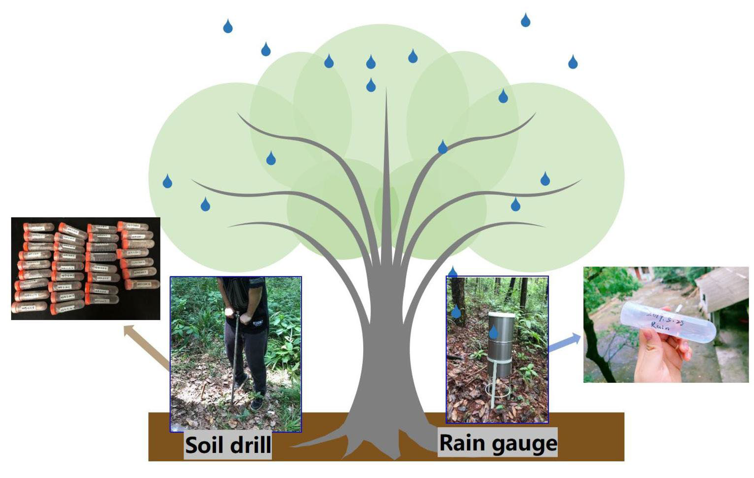
Three soil profiles with a depth of 40 cm were dug within a radius of 1 m at the center of each standard plant at each site. Each 10 cm of soil is divided into one layer and marked as S0, S1, S2, and S3. S0 is the 0–10 cm soil layer; S1 is the 10–20 cm soil layer; S2 is the 20–30 cm soil layer; and S3 is the 30–40 cm soil layer. Three samples were taken as replicates in each site according to the upper, middle, and lower slopes. In the sampling session, the soil samples were taken with a TST-55 ring cutter, a penetrometer, a 100 cm3 ring knife, and a soil auger. Three replicate samples were collected from each soil layer. The soil samples were used to determine the soil-saturated hydraulic conductivity, water penetration curves, soil moisture content, hydrogen and oxygen isotope content in soil water, and other soil physical properties.
During the observation period, the samples (soil and rainwater) with rainfall greater than 1 mm were collected each time (
Figure 3). The sampling period is 1 day before and 3 days after rainfall. This study conducted eight sampling sessions. Based on the amount of rainfall, three rainfall events of 3.6 mm (light rain), 23.5 mm (moderate rain), and 49.8 mm (heavy rain) were selected as the research objects. The soil sample storage requirements were relatively high because of the determined hydrogen and oxygen isotope content. However, the soil sample collection process should focus on sealing and freezing. After being sealed with Parafilm, the sample bottles were quickly placed in an insulated cabinet at a temperature of 0–5 °C (in the field) and then kept in a freezer at a temperature of −5 °C for a long time. The sampling time chosen was a day with no rainfall events occurring 3 days before to keep the soil moisture stable [
41].
2.4. Stable Isotopes of Hydrogen and Oxygen
The water from the soil samples was extracted with an LI-2100 automated vacuum distillation system (LI-2100, LICA, Beijing, China). An isotope ratio mass spectrometer (Finnigan Delta V Advantage, Thermo Fisher Scientific, Inc., Waltham, MA, USA) and an elemental analyzer (Flash 2000HT, Thermo Fisher Scientific, Inc., Waltham, MA, USA) were used to determine the extracted water samples and analyze the stable isotope composition of hydrogen and oxygen in each sample.
Isotopic ratios were expressed in thousands of differences from the Vienna Standard Mean Ocean Water (V-SMOW). Its formula is as follows:
where
and
represent the molar abundance ratios of the sample and V-SMOW (D/H,
18O/
16O), respectively. The measurement precision was consistently ±2‰ for
and ±0.2‰ for
.
2.5. Soil-Saturated Hydraulic Conductivity
In this study, the soil-saturated hydraulic conductivity was determined using the Mariotte bottle steady head method [
42]. The water surface height in the Mariotte bottle was always maintained at 10 cm. The infiltration water amount was measured every 10 min for 30 s during the 1st hour of the test. Subsequently, the infiltration was measured every 30 min for 30 s.
Soil-saturated hydraulic conductivity K
s is the amount of water passing through a unit area under a unit water potential gradient and unit time when the soil is saturated with water. It was computed as:
where
is the saturation hydraulic conductivity in cm·min
−1. H is the water surface height at the inlet end in cm. V is the water outflow rate in mL. L is the length of the soil column in cm. t is the water outflow time in min. A is the cross-sectional area of the soil column in cm
2.
2.6. Soil Water Characteristic Curves
Before the test started, the soil samples were soaked in 20 °C water for 12 h. Then, they were padded with filter paper and placed in a dry and ventilated place for 12 h to make the soil moisture content reach the field water-holding capacity. The temperature of the environment where the samples were kept after soaking was 25 °C. Subsequently, the soil sample was placed in the TST-55 soil water permeameter, and the water surface height of the Mariotte bottle was kept at 8 cm. When the water flowed out, the water samples were collected every 5 s until the flow reached stability. In this study, the soil infiltration rate was determined by the Mariotte bottle steady head method. The temperature was the main influencing factor of the soil infiltration function. Thus, soil infiltration rates were uniformly converted to infiltration rates at 10 °C.
Their calculation formulas are as follows:
where
is the soil infiltration rate in mm·min
−1.
is the infiltration rate at 10 °C, with the unit of mm·min
−1.
is the amount of water collected in 5 s, with the unit of ml.
is the infiltration interval in min.
2.7. Soil Dynamic Moisture Monitoring
The Watchdog 1400 soil moisture and temperature monitoring station was used to measure soil moisture and temperature. The measured soil depth was 40 cm. Four instrument probes were used, and one was placed in every 10 cm soil layer. The monitoring period was from June to August 2021, and the frequency was once a minute.
3. Results
3.1. Basic Physical Properties of Soil
3.1.1. Soil Porosity Characteristics
Soil porosity is a vital indicator of soil compactness and is positively correlated with water transport and soil storage. This study mainly explores the relationship between microporosity and soil hydrological effects. In this experiment, the variation ranges of soil total porosity (TP), capillary porosity (CP), and noncapillary porosity (NY) were 42.4%−64.9%, 27.8%−39.8%, and 14.1%−26.4%, respectively (
Figure 4). Compared with the various degrees of TP, CP, and NY in different woodlands, those in PCin were the highest, with a variation coefficient ranging from 0.075 to 0.189. The variation coefficients with TP, CP, and NY in PCin were 15.779%, 13.821%, and 20.915% higher than other woodlands.
Cf has the lowest degree of variation, with variation coefficients ranging from 0.086 to 0.369. The percentage of CP was 50% more than NY within each woodland, and CP was consistent with the changing pattern of TP. TP was taken as the key index of soil pore characteristics. As a result, the TP in the 30−40 cm soil layer was 15.515% smaller than the 0−10 cm soil layer. Furthermore, the TP of Cf decreased with the soil depth. Moreover, the TP of other woodlands initially experienced troughs and peaks successively, which fluctuated in the inverted ‘N’ shape but showed a downward trend overall.
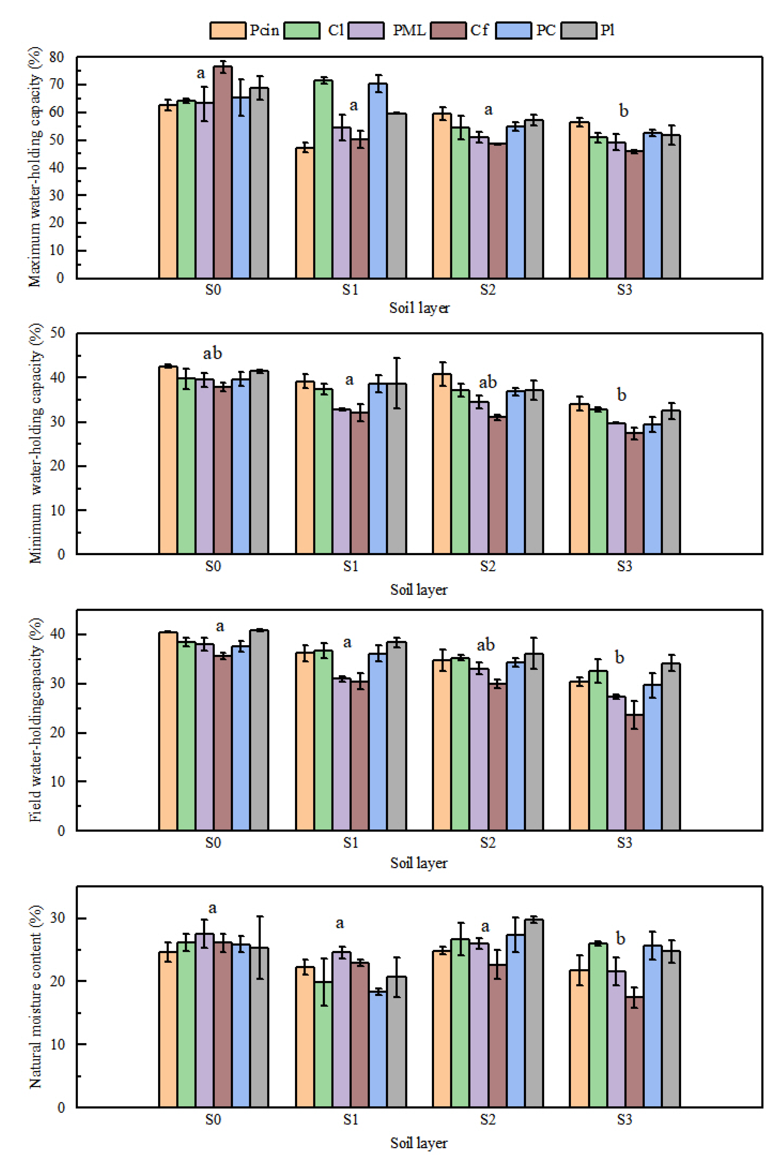
3.1.2. Soil Water-Holding Capacity
The maximum values of soil maximum water−holding capacity (MAC), minimum water-holding capacity (MIC), and field water-holding capacity (FWC) were all found in the 0−20 cm soil layer (
Figure 5). The variation ranges of MAC, MIC, FWC, and natural moisture content were 0.459−0.765, 0.274−0.426, 0.236−0.409, and 0.175−0.297, respectively. From the perspective of soil depth, the overall trend decreased with increasing soil depth. The MIC of soil was inconsistent with the MAC and FWC with soil depth, and a highly significant positive correlation existed between them (
p < 0.01).
The MIC was selected as the soil water-holding performance index through the principal component analysis method. The order of the soil water-holding capacity of the six woodlands was PCin, Pl, Cl, PC, Cf, and PML. Three significant relationships were obtained by comprehensively analyzing the correlation between the seven indexes of soil water-holding capacity. A very significant positive correlation existed between MIC and soil porosity (p < 0.01), MAC and TP had a significant positive correlation (p ≤ 0.05), and TP had a significant positive correlation with MIC, MAC, and FWC (p ≤ 0.05).
3.2. Soil Hydrological Characteristics
3.2.1. Soil-Saturated Hydraulic Conductivity
The soil-saturated hydraulic conductivity varied greatly between woodlands (
Figure 6). The variation ranges of the soil-saturated hydraulic conductivity in the six woodlands were 1.256−5.670 (PCin), 1.190−2.857 (Cl), 0.678−1.256 (PML), 0.406−0.856 (Cf), 0.912−1.923 (PC), and 1.245−4.614 (Pl). Overall, the soil-saturated hydraulic conductivity of different woodlands was significantly different. The soil−saturated hydraulic conductivity of the PCin woodland was the largest, and the variation coefficient was 1.635. However, the soil-saturated hydraulic conductivity of the Cf woodland was the smallest, and the variation coefficient was 0.679. The comprehensive analysis of the soil-saturated hydraulic conductivity variation law in the six woodlands indicated that the order was PCin, Pl, Cl, PC, PML, and Cf. In the soil profile, the soil-saturated hydraulic conductivity varied with the soil depth decrease first, then increased, and finally decreased. The maximum and minimum numerical values of soil-saturated hydraulic conductivity were in the 0−10 cm and 30−40 cm soil layers, respectively. Furthermore, the saturated hydraulic conductivity of the topsoil was 60.073% higher than the deep soil.
3.2.2. Soil Moisture Characteristic Curves
The soil moisture characteristic curves of different woodlands have a significant difference (
Figure 7). The outlet rate rapidly increased first with the test time and then stabilized. Fluctuations in the soil water penetration curve mainly occurred in the first 60 s. The volatility of the soil water penetration curve was significantly high in the PCin, Pl, and Cl woodlands. Compared with the outlet rates of other soil layers, the outlet rate of the 30−40 cm soil layer was the first to reach a steady state. The variation ranges in the outlet rates of PCin, Pl, Cl, PC, PML, and Cf were 0.98−1.80, 0.68−1.54, 0.52−1.68, 0.46−1.16, 0.46−0.76, and 0.34−0.98, respectively. The variation range of Pl was the largest, and PML was the smallest. The comparison of the average soil outflow rates of the six woodlands indicated that the order of average soil outflow rates was PCin, Pl, Cl, PC, PML, and Cf. PCin had the highest average soil outflow rates, and it was followed by Pl, Cl, PC, PML, and Cf.
3.2.3. Soil Infiltration Rate
The soil infiltration characteristics of the six woodlands are shown in
Figure 8. The variation ranges of soil initial and stable infiltration rates were 2.759−38.963 and 1.736−24.263, respectively. The soil initial infiltration rate varied in the range of 0.619−1.72, with PC and Cf exhibiting the largest and smallest values, respectively (
Figure 8a). The soil stable infiltration rate varied in the range of 0.559−1.635, with PCin and PML exhibiting the largest and smallest values, respectively (
Figure 8b). Overall, the initial infiltration rate of soil was higher than the stable infiltration rate. However, the soil initial and stable infiltration rates in Cf were smaller than the other woodlands. The comparison of the six woodlands indicated that the order of average soil infiltration rates was PCin, Pl, Cl, PC, PML, and Cf.
The soil initial and stable infiltration rates showed fluctuations with soil depth, which first decreased rapidly, then increased slowly, and finally slowed down. The overall change was the ‘W’ type. The infiltration rate of the 0−10 cm soil layer was the highest, whereas the 10−20 cm soil layer was the lowest. Compared with the soil infiltration rate between each soil layer, the infiltration rate between the 0−10 cm soil layer and the 10−20 cm soil layer varied.
3.3. Soil Moisture Content
Soil moisture is in a dynamic change state without stable regularity, and it possesses temporal and spatial variations. These two characteristics are diurnal and vertical variations in soil moisture content. Furthermore, the order of soil moisture content in the six woodlands was PCin, Pl, Cl, PC, PML, and Cf (
Figure 9). The vertical spatial perspective indicated that soil moisture content increased with soil depth. The increased rate of soil moisture content in the 0−20 cm soil layer was higher than the 20−40 cm soil layer. The trends of soil moisture content changes on the time scale under different rainfall events were consistent. The soil moisture content varied as follows: the maximum was reached on the first day after the rainfall event, and the lowest was reached on the day before the rainfall event. In general, it increased first and then decreased.
The occurrence of rainfall events can enhance the soil moisture content. Under 3.6 mm of rainfall, the soil moisture content increased by 17.34%, 10.95%, and 6.63% 3 days after the rainfall event. Under 23.5 mm of rainfall, the soil moisture content increased by 35.64%, 29.81%, and 20.70% 3 days after the rainfall event, respectively. Under 49.8 mm of rainfall, the soil moisture content increased by 81.32%, 66.97%, and 53.41% 3 days after the rainfall event. As shown above, the soil moisture content increase was the largest on the first day after the rainfall event, and it gradually decreased with time.
The comparison of the soil moisture content increases on the first day after rainfall in different soil layers indicated that the largest values were found in the 0−10 cm soil layer, whereas the smallest values were found in the 30−40 cm soil layer. The soil moisture content on the day before rainfall in different woodlands was thoroughly studied. The soil moisture content increased by 6.63%, 22.33%, and 51.94% after the rainfall events with 3.6 mm (light rain), 23.5 mm (medium rain), and 49.8 mm (heavy rain). Under the same rainfall events, the increased range of soil moisture content in different woodlands was significantly different. On the first day after rainfall, the growth rate of the soil moisture content decreased with increasing soil depth, and the second and third days after rainfall had no unity law.
At 3.6 mm of rainfall, the growth rate of the soil moisture content in PML and Pcin decreased with increasing soil depth. The growth rate of the soil moisture content in the 10–20 cm soil layer of Cf was the largest. Moreover, the maximum growth rates of soil moisture content in PC and Pl were in the 20−30 cm and 10−20 cm soil layers on the second and third days after rainfall, respectively. The maximum growth rate of soil moisture content in Cl was in the 20−30 cm and 0−10 cm soil layers on the second and third days after rainfall, respectively. Under 22.5 mm of rainfall, the growth rate of soil moisture content in other woodlands decreased with time and soil depth, except in PC. The growth rate of the soil moisture content in all woodlands decreased with time and soil depth at 49.8 mm of rainfall.
3.4. Hydrogen and Oxygen Isotope Characteristics in Soil Water
3.4.1. Soil Water Isotopic Change Characteristics
The response of soil water
to different rainfall events is shown in
Figure 10. When rainfall amounts were 3.6, 23.5 and 49.8 mm, the soil water
content variation ranges were −58.48 to 25.89, −67.91 to 25.14, and −82.34 to 23.16, respectively. Therefore, the greater the amount of rainfall, the greater the soil water
content variation range. Compared with the soil water
average increment on the first day before rainfall, the soil water
average increments when rainfall amounts were 3.6, 23.5, and 49.8 mm were 41.474%, 57.027%, and 89.365%, respectively. Thus, the increment of soil water
increased with the increase in rainfall. In general, soil water
decreased first and then increased with time. The maximum and minimum values of soil water
appeared the day before rainfall and the first day after rainfall, respectively. The minimum value of soil water
in the area occurred in PCin on the first day after 49.8 mm of rainfall.
Under 49.8 mm of rainfall (
Figure 10a−f), the soil water
of PML, Cf, and PC stands was much greater than the value of rainfall
. At the same time, the soil water
values of the 20−30cm soil layer in Pl and Cl were close to rainfall
, which was closest to the rainfall
value in the 10−20 cm soil layer of PCin. Under 23.5 mm of rainfall (
Figure 9g−l), the soil water
values of the 10−20 cm soil layer in PML, Cf, and PC were closest to the rainfall
value, and the 0−10 cm soil layer in other woodlands were closest to the rainfall
value.
Under 3.6 mm of rainfall (
Figure 10m−r), the rainfall
values were greater than the soil water
values in Pl and PCin. The dispersion degree of soil water
variation curves among soil layers varied under different rainfall amounts. The soil water
variation curves of the four soil layers were the most and least discrete under 49.8 and 3.6 mm of rainfall, respectively.
The soil infiltration process of rainwater was inferred from the trend of soil water
in each soil layer. Under 49.8 mm of rainfall, the value of rainwater
was depleted compared with the value of soil water
before rainfall. However, the soil water
decreased and then increased with time after the rain in all soil layers except for the 30–40 cm soil layer. This finding indicated that soil water was slowly infiltrating. By contrast, the soil water
before rainfall enriched the 30–40 cm soil layer on the third day after rainfall (
Figure 10a,c). Moreover, the soil water
values did not show significant fluctuations in the 30–40 cm soil layer. These results proved that the soil infiltration in PC did not reach the 30–40 cm soil depth. The rainwater
values were within the range of soil water
values and close to the soil water
values before rainfall under 23.5 mm of rainfall. The soil water
in the 10–20 cm soil layer was always the smallest among the other soil layers in all woodlands, except PML and Cl (
Figure 10g–l). Compared with the soil water
values before rainfall, the rainwater
values were enriched in PCin and Cl under 3.6 mm of rainfall. The soil water
values in the 30–40 cm soil layer in PML decreased with time after rainfall.
3.4.2. Soil Water Isotopic Change Characteristics
The response of soil water
to different rainfall events is shown in
Figure 11. The variation ranges of soil water
at 0−10 cm, 10−20 cm, 20−30 cm, and 30−40 cm soil layers were −6.430 to −1.762, −10.048 to −1.641, −11.035 to −1.712, and −6.574 to −1.302, respectively. Overall, the variation range of soil water
first increased and then decreased with soil depth. The mean values of soil water
at 0−10 cm, 10−20 cm, 20−30 cm, and 30−40 cm soil layers were −3.922, −4.370, −4.305, and −3.977, respectively. Thus, the mean values of soil water
decreased and then increased with soil depth.
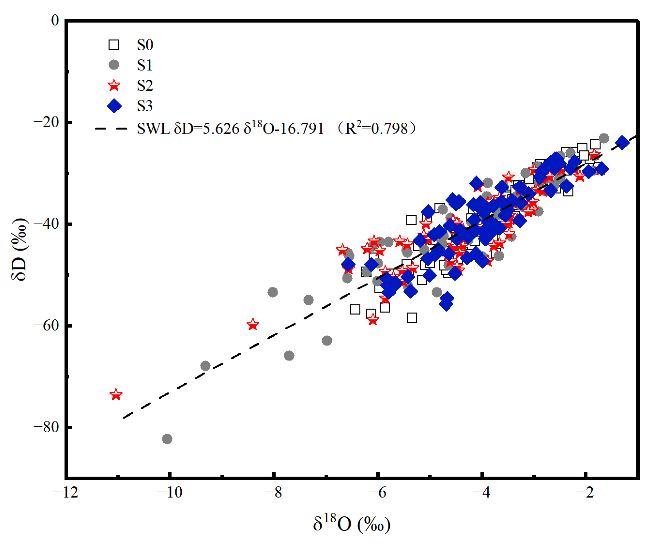
3.4.3. The Functional Relationship between Soil Water and
The soil waterline equation was a linear relationship between soil water
and
. Furthermore, the slope indicated the fractionation ratio of soil water
and
, and the constant term (intercept) indicated the degree of deviation from the equilibrium state [
43]. The relationships between soil water
and oxygen
isotopes in the Taizishan area are shown in
Figure 11. The slope and intercept in the soil waterline equation were smaller than the atmospheric waterline equation
= 8.01
+10.28 (
R2 = 0.97) [
41].
The linear relationships of soil water
and
in the six woodlands are shown in
Figure 12. As shown above, significant differences were detected in soil water hydrogen and oxygen isotope contents under different woodlands in this study (
p < 0.05). The results could be obtained through the linear fitting of soil water hydrogen and oxygen isotopes in the six woodlands (
Figure 12). The slopes in the soil waterline equation were smaller than the atmospheric waterline equation in the Taizishan area. Nevertheless, PML had the maximum slope, followed by PCin, Cf, Cl, Pl, and PC.
4. Discussion
4.1. The Basic Physical Properties of Soil
In this study, CP and NY existed simultaneously. However, the percentage of NY soil accounted for approximately 30%–45%. This result indicated that the soil permeability of the woodlands in this area was relatively good. CP and NY reflect the ability of forest vegetation to absorb and retain water, respectively. The comparison of the characteristics of soil porosity changes in the six woodlands indicated that the amount of CP was much higher than NY because of the increased vegetation in the woodland. PCin had the maximum CP, which was related to the largest canopy cover in the woodland.
The following characteristics can be obtained by studying soil porosity variation in different soil layers. Compared with deep soils, the topsoil (0–20 cm) had a high TP and NY, which accounted for a large proportion. Therefore, topsoil is the active layer with alternating soil moisture, which is in direct contact with air and is greatly affected by human activities. The TP increased slightly in the 20–30 cm soil layer because the plant roots developed in an umbrella shape in this soil layer. Plant roots enhance pore connectivity [
44]. The soil porosity increases because of the large number of roots in the soil. Therefore, the TP increased with soil depth in an N-shaped distribution. These results are inconsistent with the conclusions of some previous studies [
45].
The soil water-holding capacity is influenced by soil porosity, soil density, soil particle size, and vegetation growth conditions. Moreover, soil porosity is the most critical parameter of soil water-holding capacity. In this study, the topsoil of each woodland is most affected by human activities. The strong water-holding capacity of the topsoil is due to its loose soil and large TP. Unlike the change in NY, the minimum soil water-holding capacity of the Pl woodland was greater than the Cl woodland. The differences in TP and NY between the Pl and Cl woodlands were 0.01025 and 0.02675, respectively. In particular, the Pl woodland not only had high CP and low NY but also had high soil organic content. This phenomenon resulted in the high permeability, aeration, and water-holding capacity of Pl. Overall, soil MIC is used as a representative factor of soil water-holding capacity. Moreover, the TP has a significant influence on soil water-holding capacity.
4.2. Soil Hydrological Characteristics
Soil-saturated hydraulic conductivity is an important parameter that reflects the characteristics of different woodland TP and water-holding capacity values [
46]. In this study, the correlation analysis results showed that soil-saturated hydraulic conductivity decreased with the increase in soil fine particle content. Previous studies showed that as the fine particle content increases from 12% to 50%, the soil hydraulic conductivity decreases by more than 20-fold [
47]. The soil texture is detailed when the soil clay content is high. However, the soil-saturated hydraulic conductivity is low when the soil is in a saturated state with a low infiltration water volume.
The PCin woodland had lower soil fine particle content and larger capillary porosity than other woodlands. In addition, soil water infiltration and saturated hydraulic conductivity of the PCin woodland were higher than the other woodlands when the soil moisture reached saturation. Moreover, the soil fine particle content of the Cf woodland was higher than the other woodlands. The Cf woodland had the lowest canopy cover and the smallest TP. In addition, the soil-saturated hydraulic conductivity of the Cf woodland was the smallest of the woodlands. These results are inconsistent with the conclusions of some previous studies [
46]. The reason is that the research object is a woodland, and the root system of plants has a significant impact on the soil-saturated hydraulic conductivity. The PCin woodland had the maximum canopy cover, followed by Pl, Cl, PC, PML, and Cf. This finding is consistent with the findings on soil-saturated hydraulic conductivity. However, the soil fine particle content is not completely consistent with soil-saturated hydraulic conductivity. These results indicated that soil-saturated hydraulic conductivity was significantly influenced by canopy cover in this study; this finding is consistent with previous research [
21,
32].
The trend of soil-saturated hydraulic conductivity with soil depth can be explained by the influence of plants on soil moisture movement. A significant relationship exists between plant root characteristics and the soil water spatial distribution pattern [
48]. Root activity has an important impact on soil development [
49]. The root systems of shrubs and herbs are distributed in the shallow soil layer, which has a strong capacity for rainfall interception and water consumption. This scenario results in the subsurface soil layer from low aquifers. Therefore, the saturated hydraulic conductivity of the topsoil is higher than the subsurface soil layer. Underground soil has a low fine particle content, high infiltration water, and low water consumption, leading to a high soil-saturated hydraulic conductivity.
The soil macropore outflow rate showed differences with time. It exhibited a trend of increasing uniformly from 0 s to 55 s, decreasing from 55 s to 100 s, and stabilizing after 100 s. At the early stage of water transport, soil macropores had a facilitating effect on soil hydraulic conductivity. The soil macroporosity number density of PCin, Cl, and Pl were 1.704, 1.471, and 1.313 cm
−3, respectively. However, the number density of soil macroporosity in the other three woodlands did not exceed 1 ·cm
−3. A slight difference existed in the number of soil macropores and small pores of less than 1.60 mm in the PCin, Cl, and Pl woodlands. Therefore, the soil macropores were gradually filled with water when the water was transported into the soil in the early stage; this finding is consistent with previous research [
50]. The water movement process became complicated because the number of soil macropores was large. Moreover, the soil moisture characteristic curves showed fluctuation. In particular, the PCin woodland had the maximum soil pore density, followed by Cl, Pl, PC, PML, and Cf. These differences probably occurred in the canopy cover. Therefore, the average soil infiltration rate in the Pl woodland was greater than the Cl woodland.
Plant roots can significantly improve soil infiltration [
50]. The results of the TP indicated that it was consistent with the characteristics of soil water infiltration. Overall, the TP represented the characteristic parameters of soil porosity. The soil macropore number of the 20–30 cm soil layer was slightly greater than the other soil layers in the PML and Cf woodlands. The 0–10 cm soil layer within the four other mixed woodlands had the greatest macropore number and outflow rate. Therefore, the 0–10 cm soil infiltration rate was the greatest. However, previous studies revealed that the soil infiltration rate and water storage capacity were significantly high in the 0–20 cm soil layer [
51]. This finding is probably due to differences in soil water stratification among different study areas. Overall, the infiltration rate of surface soil was the highest. As shown above, the 10–20 cm soil layer had the lowest macropore number, outflow rate, and soil infiltration rate. Therefore, the soil outflow rate was positively related to the number of soil macropores. The number of soil pores in the 30–40 cm soil layer was greater than the 10–20 cm soil layer. However, the opposite was true for TP. According to the definition of porosity, the 30–40 cm soil layer is compact and can easily reach a stable infiltration state.
4.3. Soil Moisture Content
Rainwater is an important material source of soil moisture. The soil moisture potential gradient increased with rainfall, thereby increasing the soil moisture content. The results indicated that the rate of increase in soil moisture content was positively related to MIC (
p < 0.01). These results are inconsistent with the conclusions of some previous studies [
12]. The soil texture in the Loess Plateau area is loess soil; however, the soil particle composition between soil layers has no significant difference [
17,
31]. Nevertheless, the Taizishan area has viscous yellow-brown soil, and the soil particle composition between soil layers has significant differences.
Soil moisture content changes because of the combination of soil moisture infiltration and evaporation. Precipitation directly supplies the ‘material source’ of soil water transport. The ground surface was rapidly moist when precipitation was high. However, the water that accumulated in the topsoil continued to supply soil water infiltration after the rainfall event. Soil moisture infiltrates well into the deep soil layers when precipitation is low [
52]. The soil moisture content decreased rapidly because of the soil moisture consumption by evaporation and plant growth. The soil moisture content variations of each soil layer initially increased and then decreased with time after rainfall. The wave peak was generally present on the first day after the rainfall event. As shown above, the topsoil moisture content could peak within 24 h from the start of rainfall timing in this study.
The comparison of the mean soil moisture contents of the six forests indicated that the four mixed forests had high contents. These results are consistent with the conclusions of some previous studies [
21,
53]. The soils under the canopy of conifers showed the most severe soil water repellency levels. In the upper layers, plant transpiration and soil evaporation can consume 60% of the total precipitation [
54]. Therefore, the mixed forests had low canopy closure and large water loss, and the upper soil moisture content was low. The trend of the soil moisture content growth rate was consistent at a high rainfall amount but complex at a low rainfall amount [
10]. The reason is that soil moisture simultaneously experiences a mixed effect of infiltration and transport after a rainfall event. Infiltration is the main driving force of soil moisture movement when the rainfall amount is high. Nevertheless, the main driving force, which is mainly affected by soil texture, canopy cover, and other factors, is not obvious when rainfall is low.
The vegetation type of Cf includes simple plants, such as ferns and herbs. These shallow-rooted plants have the characteristics of small root morphology and are divided into the 0–20 cm soil layer. Therefore, the TP of the Cf woodland decreased with soil depth. The results indicated that the TP and soil moisture storage capacity of the 10–20 cm soil layer in the Cf woodland were larger than the other soil layers. The small canopy density of the forest strengthens the peak attenuation of the surface soil moisture [
13]. Therefore, the growth rate of the subsurface soil moisture content of the 10–20 cm soil layer in Cf was the largest. The maximum value of the soil moisture content growth rate moved between different soil layers. This finding indicated that the magnitude of the forces acting on soil moisture changes over time.
4.4. Hydrogen and Oxygen Isotope Characteristics in Soil Water
According to statistics, the slope and intercept in the soil waterline equation are smaller than those in the atmospheric waterline in this area. The stable isotopic composition of soil water is more enriched than that of atmospheric precipitation. This finding is consistent with previous research [
41]. The isotope enrichment in soil water results from the large amounts of soil water evaporation through the topsoil. On the contrary, woodland evaporation is strong in this area. In typical rainfall processes with a long rainfall duration and high rainfall amounts, the isotopic effect leads to the depletion of isotopic values with rainfall duration; this finding is consistent with previous research [
18]. Intense evaporation is required for the relative enrichment of soil water
in sufficient rainfall amounts. The soil water
in the topsoil layer (0–20 cm) is close to precipitation.
The soil water evaporation decreases with soil depth [
55]. Thus, the topsoil water is subject to strong dynamic fractionation caused by the combination of evaporation and precipitation infiltration. The change in
in topsoil water is obvious. The analysis of the
value dispersion degree of different soil layers indicated that a large amount of precipitation increases each soil layer’s soil water
dispersion degree. Surface water movement is a complex process influenced by infiltration and evaporation under large precipitation. ‘New water’ promotes the downward migration of ‘old water’. This process requires a strong evaporation effect, resulting in the relative enrichment of deep soil water
. Moreover, light mass isotope molecules have preferential evaporation properties during soil moisture evaporation, leading to the enrichment of heavy mass isotopes in topsoil water [
56]. These results indicated that the topsoil has the lowest moisture content and most pores, the amount of topsoil aqueous phase (from liquid water to gaseous water) is the highest, and the stable isotope is the most enriched.
Soil water infiltration forms differ under different rainfall amounts [
55]. In the present study, soil water
fluctuated between soil water
and rainwater
3 days after the rain. This finding indicated that the main form of soil water infiltration in Cf, PC and Cl was precipitation combined with the soil’s original water content under 49.8 mm of rainfall (
Figure 10b,c,e). Compared with that before rainfall, the soil water
in each soil layer on the 1st day after rainfall in Cf, PC and Cl was shifted to different degrees under 23.5 mm of rainfall (
Figure 10h,i,k). The soil water
in the 20–30 cm soil layer was close to the value of rainwater
, and the soil water
in the 30–40 cm soil layer was close to that of soil water
in the 0–20 cm soil layer before rainfall. These results indicated that precipitation in these three woodlands drove topsoil water downwards under moderate rain. Overall, the changes in soil water
under the three rainfall events indicated that the soil water infiltration form in PML, Cf and PC was the precipitation mixed with original soil water that diffused downwards. In addition, the soil water infiltration form in Pl, Cl and PCin drove out the original soil water.
As shown above, significant differences were detected in the
values under different rainfall events in this study. These differences were probably produced by the differences in vegetation factors, such as canopy cover and stand canopy closure [
1]. Under heavy rainfall, the soil water
enrichment at the 30–40 cm soil layer in the PML woodland is consistent with previous research [
57]. The slope of the PML woodland was greater than 15°. Thus, the upper part of the water was supplied to the sampling site. These results help in understanding that the stand canopy closure and initial soil moisture content directly affect precipitation and soil water evaporation, respectively.
PCin had the highest average soil moisture content and the lowest coefficient of variation because of the large stand canopy closure. The soil moisture loss rate and evaporation decreased when the solar radiation was reduced. Therefore, the soil water of PC in woodland was relatively poor, whereas the slope of the soil waterline was large. Overall, the soil water was enriched in needleleaved forests and relatively depleted in mixed conifer broadleaved forests. The PCin mixed conifer broadleaved forests exhibited high canopy cover, well-developed root systems, and large soil porosity of topsoil. As shown above, significant differences were detected in the TP under different soil layers. The mixed conifer broadleaved forest construction mode improved soil quality and increased the content of fine soil particles and soil adhesion.
4.5. Functional Model
In this study, stepwise regression was used to research the effects of basic forestland conditions, soil hydrological properties, and soil particle composition on soil moisture characteristic parameters. According to the stepwise regression results,
Ks,
, and
can be expressed as a power function relationship of field water-holding capacity, slope, and very coarse sand content. Their calculation formulas are as follows:
where FWC, S, and VC are the field water-holding capacity, slope, and extremely coarse sand (1–2 mm) particle content, respectively. According to the regression equation, VC was the main parameter affecting soil-saturated hydraulic conductivity, whereas the slope was the main factor affecting soil water
and
. These results are consistent with previous studies [
52].
5. Conclusions
Based on stable isotope technology, this study quantified soil moisture characteristics in different woodlands in Hubei, China. The results indicated that soil hydrological characteristics were greatly influenced by slope, field water-holding capacity, and extremely coarse sand (1–2 mm) particle content, whereas the saturated hydraulic conductivity of the 0–20 cm topsoil layer was 60.073% higher than the 20–40 cm soil layer. The mean soil moisture content of the four mixed forests was higher than the pure forests. The soil waterline equation in this area was = 5.626 − 16.791 (R2 = 0.798). Moreover, the slope and intercept in the soil waterline equation were smaller than the atmospheric waterline equation. This finding indicated that the woodland evaporation in this area was strong. Surface water movement is a complex process influenced by infiltration and evaporation under large precipitation. The soil water of the soil surface (0–20 cm) was close to precipitation and fluctuated with time. This phenomenon was related to the few macropores and small evaporation of deep soil. Nevertheless, the soil water and values of the 20–40 cm soil layer changed flatly with time. Needleleaved woodlands’ evaporation was strong, resulting in soil water enrichment. Therefore, mixed conifer broadleaved woodlands’ evaporation was weak, resulting in relatively depleted soil water. Soil water and in the topsoil were relatively enriched. The mixture of rainwater and soil water downward diffusion was dominant in pure forests (PML and Cf), whereas the precipitation replacement of old soil water before the rain was dominant in mixed forests (Pl, Cl, and PCin). VC was the main parameter affecting soil-saturated hydraulic conductivity, and the slope was the main factor affecting soil water and .


