Article

End-to-End Learning for Visual Navigation of Forest Environments

School of Electronics and Computer Science, University of Southampton, Southampton SO17 1BJ, UK
*
Author to whom correspondence should be addressed.
Forests 2023, 14(2), 268; https://doi.org/10.3390/f14020268
Submission received: 1 December 2022 / Revised: 25 January 2023 / Accepted: 27 January 2023 / Published: 31 January 2023

Abstract

:
Off-road navigation in forest environments is a challenging problem in field robotics. Rovers are required to infer their traversability over a priori unknown and dynamically changing forest terrain using noisy onboard navigation sensors. The problem is compounded for small-sized rovers, such as that of a swarm. Their size-proportional low-viewpoint affords them a restricted view for navigation, which may be partially occluded by forest vegetation. Hand-crafted features, typically employed for terrain traversability analysis, are often brittle and may fail to discriminate obstacles in varying lighting and weather conditions. We design a low-cost navigation system tailored for small-sized forest rovers using self-learned features. The MobileNet-V1 and MobileNet-V2 models, trained following an end-to-end learning approach, are deployed to steer a mobile platform, with a human-in-the-loop, towards traversable paths while avoiding obstacles. Receiving a 128 × 96 pixel RGB image from a monocular camera as input, the algorithm running on a Raspberry Pi 4, exhibited robustness to motion blur, low lighting, shadows and high-contrast lighting conditions. It was able to successfully navigate a total of over 3 km of real-world forest terrain comprising shrubs, dense bushes, tall grass, fallen branches, fallen tree trunks, and standing trees, in over five different weather conditions and four different times of day.

1. Introduction

An estimated 3 trillion trees, mostly in forests that cover 30% of the Earth’s landmass, are important for maintaining our ecosystems and counteracting climate change [1,2]. The management, maintenance and conservation of forests are enormous operations. Forests need to be adapted to stay resilient in the face of new rainfall patterns, increased wind, more generations of insect pests per year, and the arrival of new pathogens [3]. At present, forests are monitored on a large scale from space [4], and more locally with aerial surveys [5]. However, many aspects of tree growth and health can best be determined from below the canopy, or require access to the ground. Conceivably, a sparse swarm of rovers could assist in monitoring forests [6]. The swarm could gather spatio-temporal information, such as census data on healthy tree saplings, or visually inspect bark and leaves for symptoms of devastating invasive diseases [7]. A swarm could collaboratively estimate the locations of forest areas that are prone to wildfires, enabling precise preventive measures [8]. Importantly, the individual rovers of the swarm have to be small-sized (portable) to reduce their environmental impact, such as from soil compaction [9]. The rovers also have to be inexpensive to allow their large-scale deployment as a swarm.
Off-trail navigation in forest environments is an open problem in field robotics [10]. Forest environments comprise a variety of different vegetation such as leaves, twigs, fallen branches, grass, shrubs, standing and fallen trees, and overhanging bushes. Rovers are required to predict the terrain traversability over a priori unknown forest terrain relying solely on onboard sensors, and do so under varying lighting and weather conditions [11,12]. Furthermore, the prediction of the rover–terrain interactions is not only impacted by terrain and the weather conditions (such as wet versus dry foliage), but also susceptible to changes experienced by the rover in prolonged operation (e.g., mud sticking to the rover’s wheels) [13]. For small rovers with a low camera viewpoint, which is easily occluded by compliant vegetation such as grass or overhanging leaves, forest navigation is especially challenging.
Off-road terrain traversability for ground robots has been investigated in numerous studies (c.f. [14,15]), often motivated by the DARPA programs [16,17]. Machine learning algorithms for off-road navigation typically utilize hand-crafted features [18] engineered by experts based on the application scenario and the rover’s operating environment. In structured environments, these rely mainly on geometry (e.g., slope, step and roughness features of city walkways [19]) and appearance (color and texture of obstacles [20]). Unstructured environments typically require engineered features of proprioceptive information such as drive electrical currents, acceleration forces and chassis orientation on uneven terrain [18,21], in addition to geometry and appearance-based features. For example, features engineered from proprioceptive sensors, particularly the mean slope of terrain profiles from chassis orientation, were used in [22] for mobility prediction models.
Hand-crafted features have limitations for terrain traversability analysis in off-road environments. Features engineered from geometric data, such as terrain roughness and slope, are often unreliable in unstructured environments due to limited depth information [23,24]. Estimated digital elevation maps can be incomplete due to occlusions [23]. Compliant vegetation, such as high grass, is difficult to be captured with engineered geometry-based features [24]. Hand-crafted visual features (e.g., color and textural descriptors) suffer from environmental factors such as high-contrast lighting [25,26]. In summary, hand-crafted features are impaired by engineering bias and often lead to poor discriminative power [27]. Hand-crafted features that are robust to compliant objects, deep shadows, and motion blur are complicated to engineer, computationally expensive to run, and often brittle in varying environmental conditions.
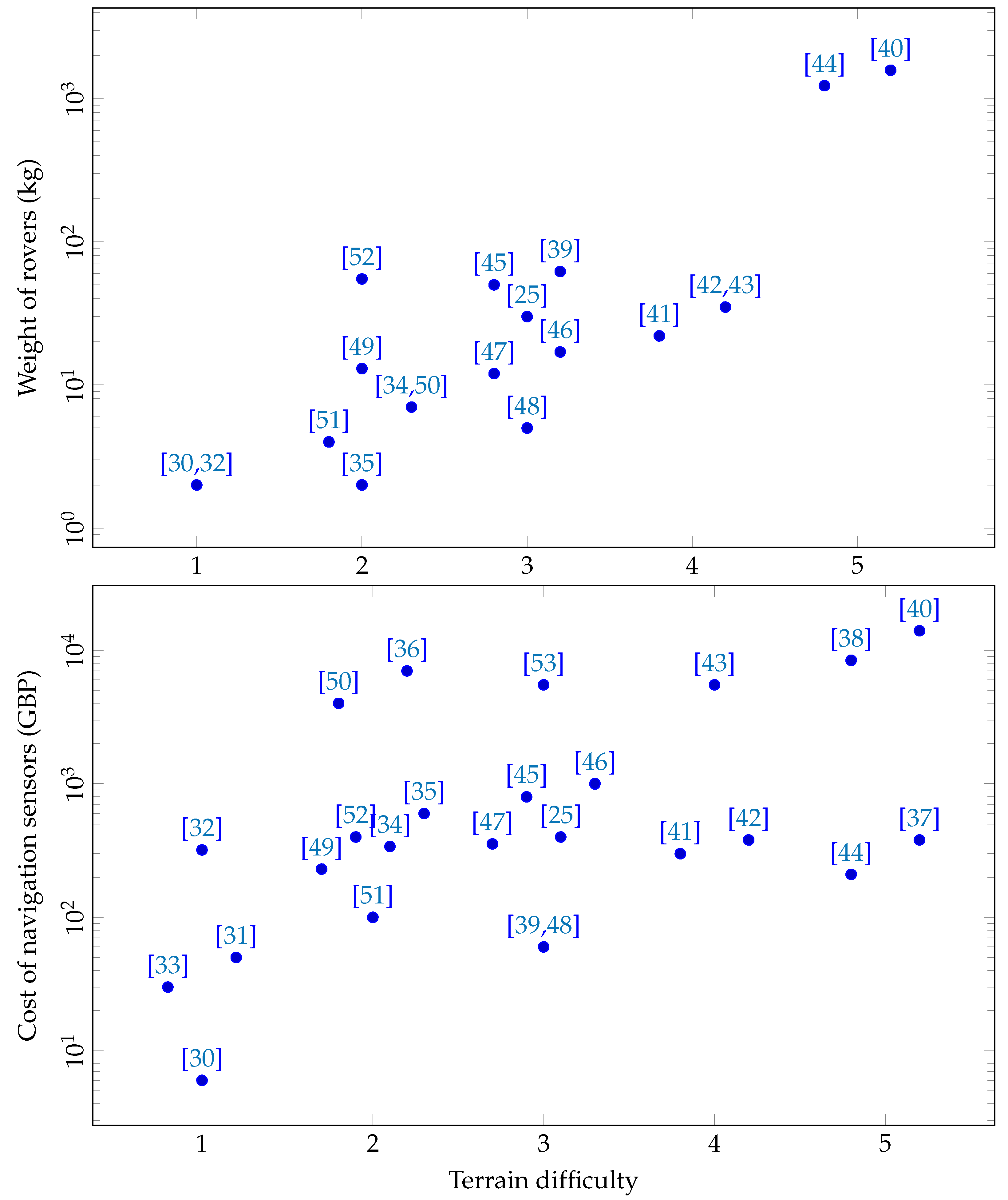
In contrast to hand-crafting, many recent studies have turned to self-learned features trained using end-to-end learning to directly output steering actions for a rover (see Figure 1 and Table A1). Steering prediction algorithms following end-to-end learning have been successfully applied in structured environments, such as in mazes [28,29], following colored tracks [30,31,32,33] and corridors [25,34,35,36]. In outdoor environments, algorithms using end-to-end learning have demonstrated some promising results in autonomous driving on well-paved roads in structured urban environments under varying lighting and weather conditions [37,38,39,40]. Moreover, recently, a few studies have investigated end-to-end learning algorithms for off-road navigation [41,42,43]. For example, using control policy predictions of steering and throttle commands trained using an end-to-end imitation learning approach, a 1/5-scaled RC vehicle was able to successfully navigate a dirt track—without obstacles—at high speed [41]. However, the application of end-to-end learning for small-sized rovers navigating forest environments comprising a variety of compliant (grass, shrubs) and rigid obstacles (fallen branches, tree stems) from a viewpoint tens of centimeters off the ground remains to be investigated.
We propose a low-viewpoint navigation system for small-sized forest rovers, trained using end-to-end learning. This approach targets the uncharted bottom-right region in Figure 1. A mobile platform is designed to easily capture and automatically label training data of forest scenes, RGB images at a low-viewpoint. Four different state-of-the-art lightweight convolution neural networks—DenseNet-121, MobileNet-V1, MobileNet-V2 and NASNetMobile—have been investigated for multiclass classification of steering actions. The models are trained using real-world forest data captured from the Southampton Common woodlands (Hampshire, UK). From the four models, the MobileNet-V1 and MobileNet-V2 are selected for field experiments due to their high accuracy and runtime performance. To sidestep the additional challenges of designing a high-endurance locomotion system for a small-sized low-cost rover, in this study, we focus solely on the navigation system. Therefore, the mobile platform is pushed manually by an operator, guided by the steering actions of the classification model running on a Raspberry Pi onboard the platform. The developed low-viewpoint navigation algorithm uses a 128 × 96 resolution RGB image. Navigation using the developed classification model has been extensively tested in field trials, successfully navigating a total of over 3 km of real-world forest terrain under five different weather conditions and four different times of day, including high-contrast sunlight and low-lighting at dusk.

2. Materials and Methods

Our algorithm for forest navigation employs deep neural networks to train a multiclass classification model following end-to-end learning. Training data for the classification comprise RGB images and corresponding steering actions, obtained by an operator pushing the mobile platform through the forest. The trained models infer steering actions from RGB images in real-time, on an onboard embedded computer, with sufficient accuracy to facilitate navigation of the forest environment.
Training data for forest navigation: Data was collected at the Southampton Common (Hampshire, UK), a large area of over 1.48 km 2 featuring woodlands, rough grassland, ponds, wetlands and lakes. Several paths of the woodlands, both on-trail and off-trail and totaling over 600 m, were selected for recording data. The selected paths comprised a number of different obstacles such as grass, bushes, fallen tree branches, leaf litter, and fallen and standing trees.
The customized mobile platform was manually pushed by an operator along the paths to be recorded (for platform details, see [11]). On the platform, two incremental photoelectric rotary encoders were attached to a CamdenBoss X8 series enclosure box (L × W × H: 18.5 × 13.5 × 10 cm). Two black polyurethane scooter wheels were mounted on either side of the enclosure, one for each encoder. The wheels were 10 cm in diameter and 2.4 cm in width to enable traversal over rough terrain. The encoders were connected to a Micropython enabled Adafruit ItsyBitsy M4 Express ARM board, which made the time stamped rotary encoder readings available over a USB connection. The enclosure was mounted at the end of a 1.21 m telescopic extension pole, allowing the operator to roll the enclosure on its wheels along the ground by pushing it forward while walking. Inside the enclosure, an Intel RealSense D435i camera was mounted 15 cm above the ground with a free field of view in the direction of motion. The rotary encoder data were time synchronized with the recorded RGB images from the camera at 30 frames per second, and recorded at the same rate. A laptop computer connected to the camera, and to the USB connection from the rotary encoders, was used to store the data.
The operator pushed the mobile platform along forest paths while performing go straight (GS), turn left (TL), turn right (TR) and go back (GB) actions. All the actions were performed as discrete movements to ensure the wheels of the mobile platform rotated smoothly on challenging forest terrain, to provide reliable encoder data. With the GS action, the platform was pushed straight approximately 50 cm forward. Rotatory actions of TL and TR pivoted the platform by approximately 15 along the yaw axis. Finally, the GB action rotated the platform by approximately 180 . The actions allowed the operator to navigate the mobile platform through the forest, avoiding collisions by steering around the obstacles, and turning around when there were no traversable paths to circumvent the obstacles.
In total, 29,005 RGB images were recorded by the mobile platform. To automatically label the recorded RGB images for training the multiclass classification models, the left and right wheel encoder data were used to label the corresponding timestamped RGB images. The images were labeled as one of GS, TL, TR and GB according to the steering angle of the platform. A few of the GB labeled RGB images had to be manually re-labeled as TL or TR (around 1% of the recorded data), if there was a traversable path on the far left or far right of the image, respectively. Following the labeling, we had 19,573, 3037, 3527, and 2868 images for the GS, TL, TR and GB actions, respectively. Subsets of the recorded data were used for training (70%), validation (15%) and testing (15%) the multiclass classifier models (see Table A2 in Appendix A for details).
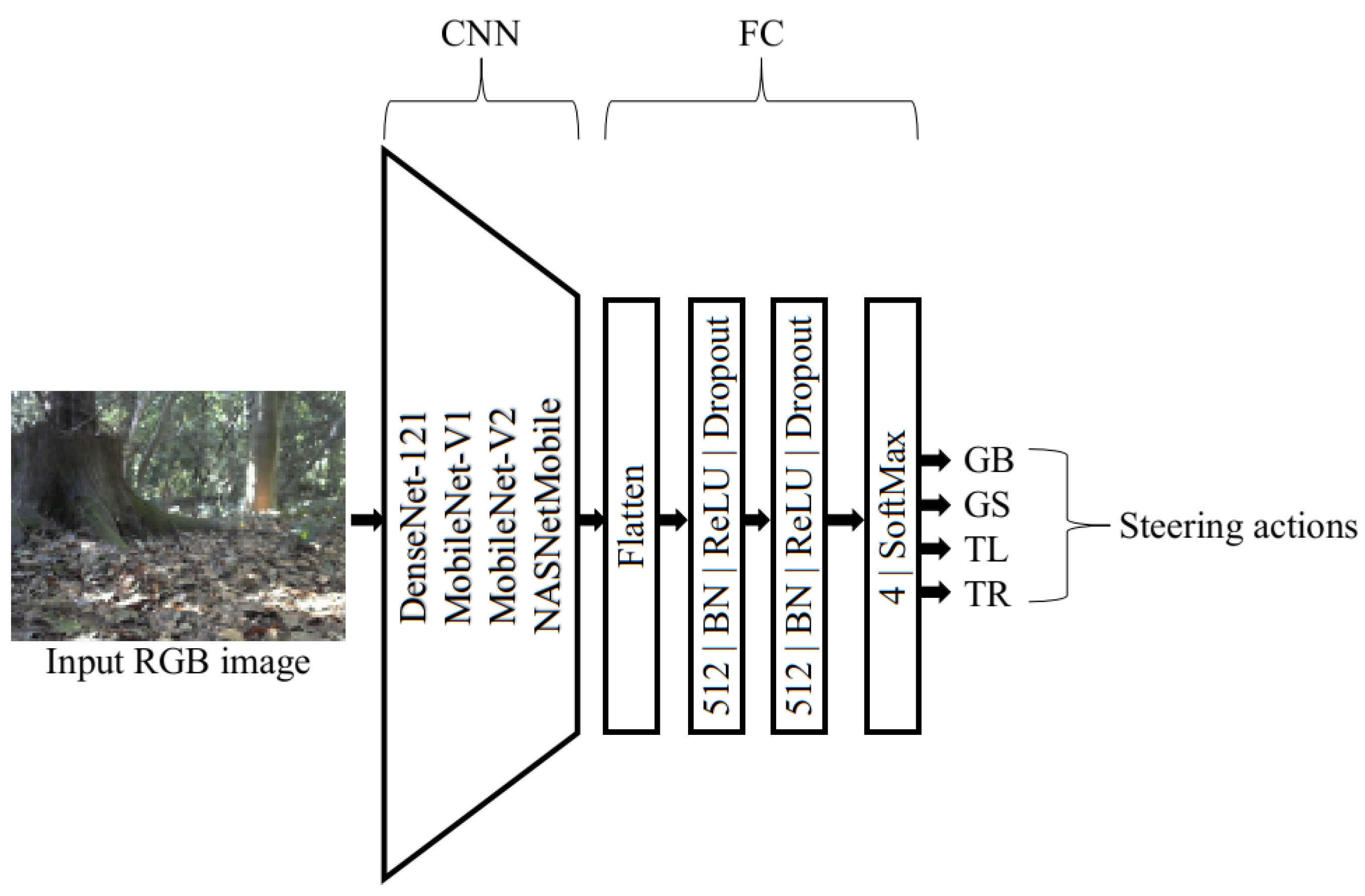
Classification models: The multiclass classification models are required to infer steering directions (GS, TL, TR and GB) from input RGB images in real time. As the models are to be deployed on low-cost embedded computers, for our study, we compare four state-of-the-art light-weight neural networks—DenseNet-121 [54], MobileNet-V1 [55], MobileNet-V2 [56] and NasNetMobile [57]. The implementations of these networks are available at Keras (Keras is a deep learning API written in Python, see https://keras.io/api/applications, accessed on 23 November 2020)
The initial weights of the DenseNet-121, MobileNet-V1, MobileNet-V2 and NasNetMobile models had been pre-trained on the ImageNet dataset [58] to speed up the model convergence. Subsequently, we unfroze all the layers in the investigated models and retrained them on our forest data. For steering direction prediction, a flattened convolutional layer followed by three fully connected (FC) layers were added to the models (see the architecture in Figure 2). The first two FC layers had a rectified linear unit activation, and the last FC layer employed a softmax activation for steering direction selection. Batch normalization and dropout operations (probability of 0.2) were employed after each FC layer to prevent overfitting of the data [59]. For a fair comparison across the models, all the RGB images in the training data were downsampled to 224 × 224. Each of the models were trained for 20 epochs with a batch size of 16, using the Adam optimizer with a categorical cross-entropy loss (log-loss) function [60]. All of the models were implemented in TensorFlow [61] and Keras [62], and trained on a NVIDIA GTX 1080ti (11G) GPU. Training took approximately 16h (DenseNet-121), 7h (MobileNet-V1), 8h (MobileNet-V2) and 10h (NASNetMobile) on a NVIDIA GTX 1080ti (11G) GPU for 224 × 224 resolution RGB images. The trained Tensorflow models were compiled into TensorFlow-Lite models [63], resulting in over a ten-fold improvement in runtime performance.
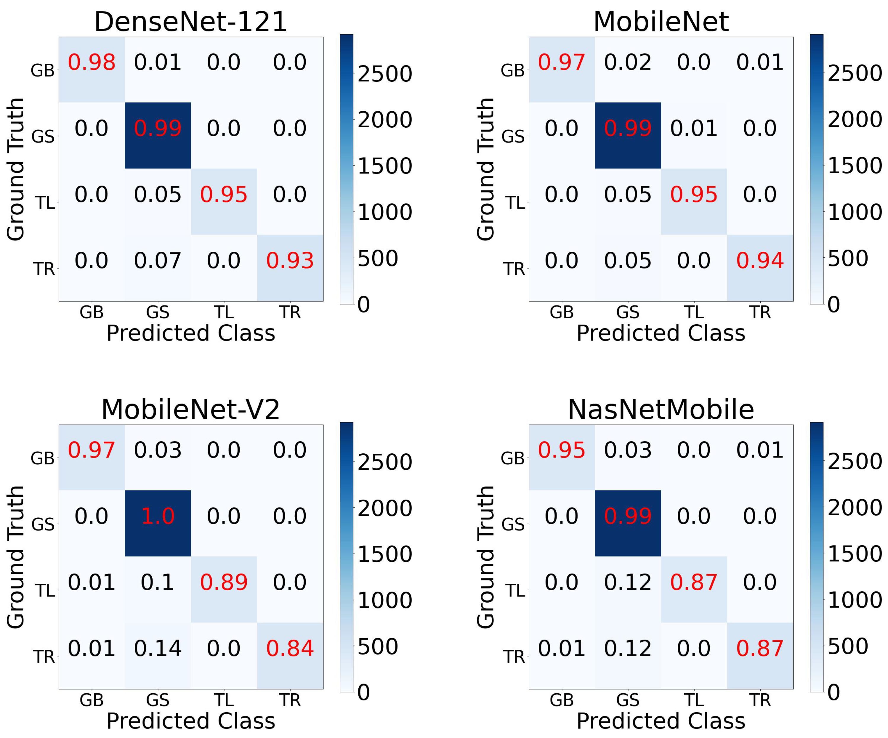
The trained DenseNet-121, MobileNet-V1, MobileNet-V2 and NASNetMobile models all achieved a high classification performance on the tested RGB images (see the accuracy and log-loss in Table 1). In particular, all four models were largely able to accurately classify the GS, TL, TR and TB steering actions, with the DenseNet-121 model attaining a high overall accuracy across all four classes (see confusion matrix in Figure 3). The high accuracy in steering action classification was further supported by a 5-fold cross-validation (see the details in Table A4 in Appendix A). However, the DenseNet-121 model was impaired by a high runtime, requiring over twice the time as the other models to classify the images on a Raspberry Pi 4 (see the runtime in Table 1). Therefore, in considering the tradeoff between accuracy and runtime, the MobileNet-V1 and MobileNet-V2 were selected for field experiments.
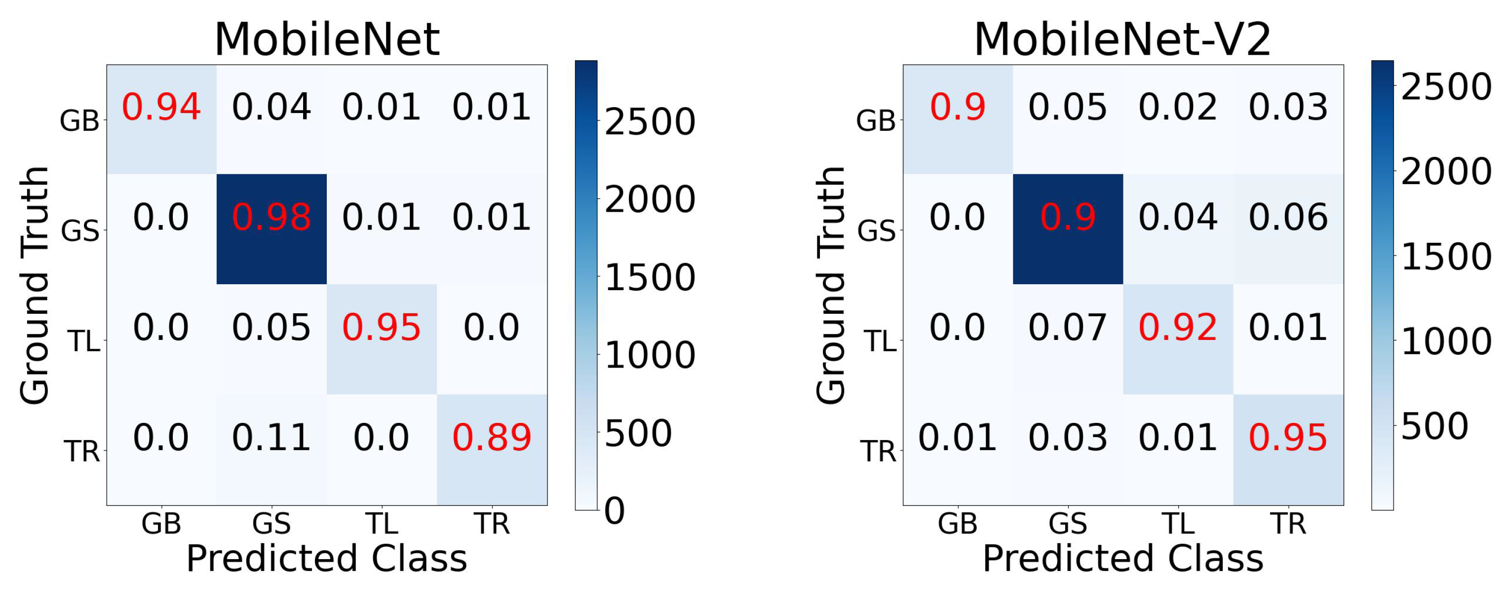
For the field experiments, the runtimes of the selected MobileNet-V1 and MobileNet-V2 models were improved by downsampling the resolution of the 224 × 224 RGB images input into the model. Therefore, these two models were retrained following the same experimental setup (20 epochs with a batch size of 16) after downsampling the RGB images of the training data to 128 × 128, 128 × 96, 64 × 64, and 32 × 32, in separate and independent experiments. The results from our parameter tuning experiments indicated a steep drop in accuracy at resolutions below 128 × 96 (see Table A3 in Appendix A for MobileNet-V1; similar trends in accuracy were observed for MobileNet-V2). Consequently, the MobileNet-V1 and MobileNet-V2 models trained with 128 × 96 resolution images (see the performance details in Table 2, the 5-fold cross-validation in Table A5 in Appendix A, and the confusion matrix in Figure 4) were deployed for the field experiments.
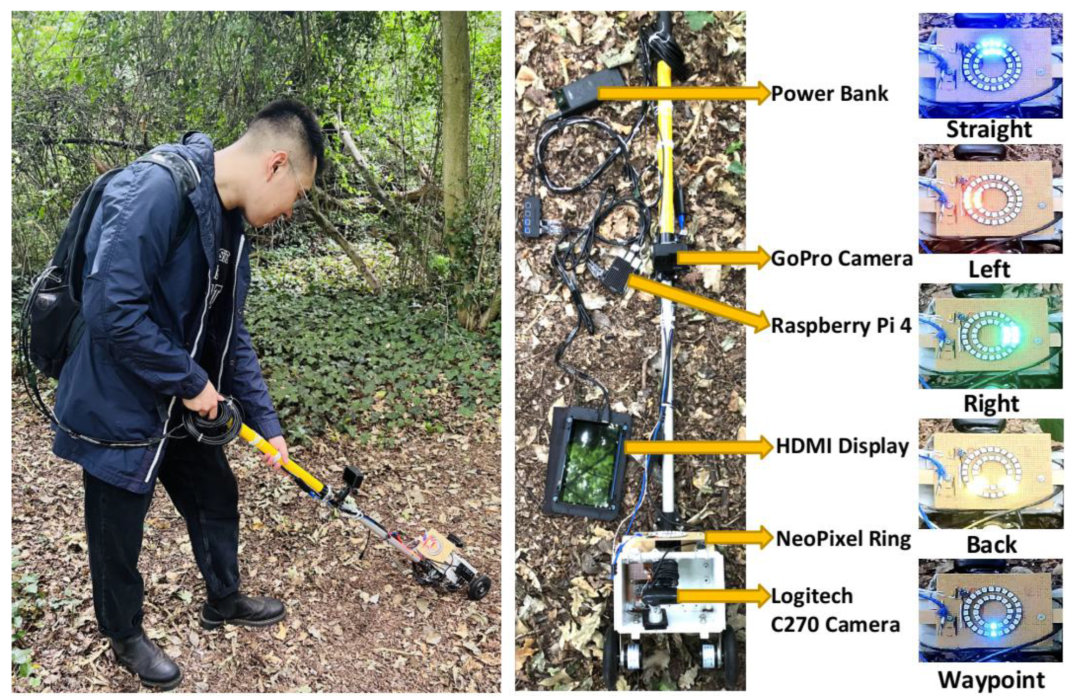
Mobile platform for field experiments: The mobile platform deployed to assess our multiclass classification models in field experiments was similar to the platform used to gather training data, but with a low-cost RGB webcam for capturing input images, and the addition of display hardware for the output steering commands to be visible to the operator (see the platform and operator in Figure 5). A Logitech C270 HD webcam (diagonal 55 field of view) was mounted inside the enclosure (replacing the Intel RealSense D435i camera) at 18 cm above the ground and was connected to a Raspberry Pi 4. Additionally, a stripboard (9.5 × 12.7 cm) was fixed to two rectangular wooden blocks on the top of the enclosure, alongside two concentric NeoPixel rings of addressable RGB LEDs (Adafruit Industries, New York, NY, USA). The two NeoPixel rings were connected to the Raspberry Pi 4 (4 GB RAM) via a twisted pair (data) and a USB cable (power), while a Schmitt-trigger buffer (74LVC1G17 from Diodes Incorporated, Plano, Texas, USA) in the serial data line was used to overcome the capacitance of the long twisted pair wire. A HERO 9 (GoPro, San Mateo, CA, USA) action camera was also mounted on the telescopic pole 50 cm from the top of the enclosure for a third-person view high-resolution video recording of the field experiments.
The RGB images captured by the Logitech camera every four seconds—one control-cycle—were input into the multiclass classification model deployed on the Raspberry Pi. Subsequently, the classification model output a steering direction—one of GS, TL, TR and GB—which was displayed on the NeoPixel rings (see Figure 5 for details on the direction indications). A fifth action, labeled waypoint, was introduced for the field experiments. The waypoint action superseded the direction outputs of the classification model. It prompted the operator to rotate the platform towards the direction of the goal waypoint. The action occurred every 10 control-cycles and in general could be based on GPS information.

3. Experiments

The field experiments to investigate the performance of the developed MobileNet-V1 and MobileNet-V2 multiclass classification models for forest navigation were performed in the Southampton Common woodlands. The experiments were performed for the following two scenarios: (i) following a long forest trail; and (ii) steering through a smaller but more challenging off-trail forest environment.
The performance of the classification models in navigating the forest was assessed with the following metrics: (i) the total distance traversed by the mobile platform to reach its target waypoint; and (ii) turning rate—the proportion of times the mobile platform steered left and right, which is zero for a straight-line trajectory to the target and in general is unbounded (arbitrary long detours and many arbitrary turns without forward progress).
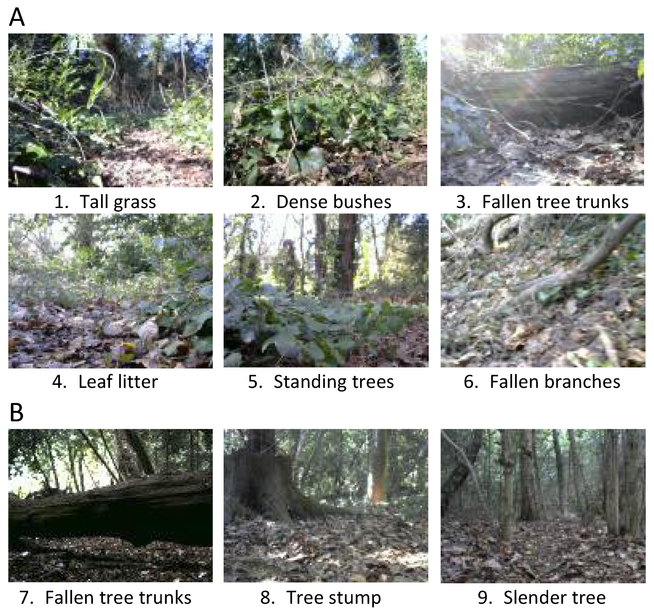
Following a long forest trail: The mobile platform was navigated over a dried mud trail of around 120 m, comprising various compliant and rigid obstacles. Obstacles on and around the trail included dense bushes, tall grass, leaf litter, fallen branches, fallen tree trunks, and standing trees (see examples in Figure 6A).
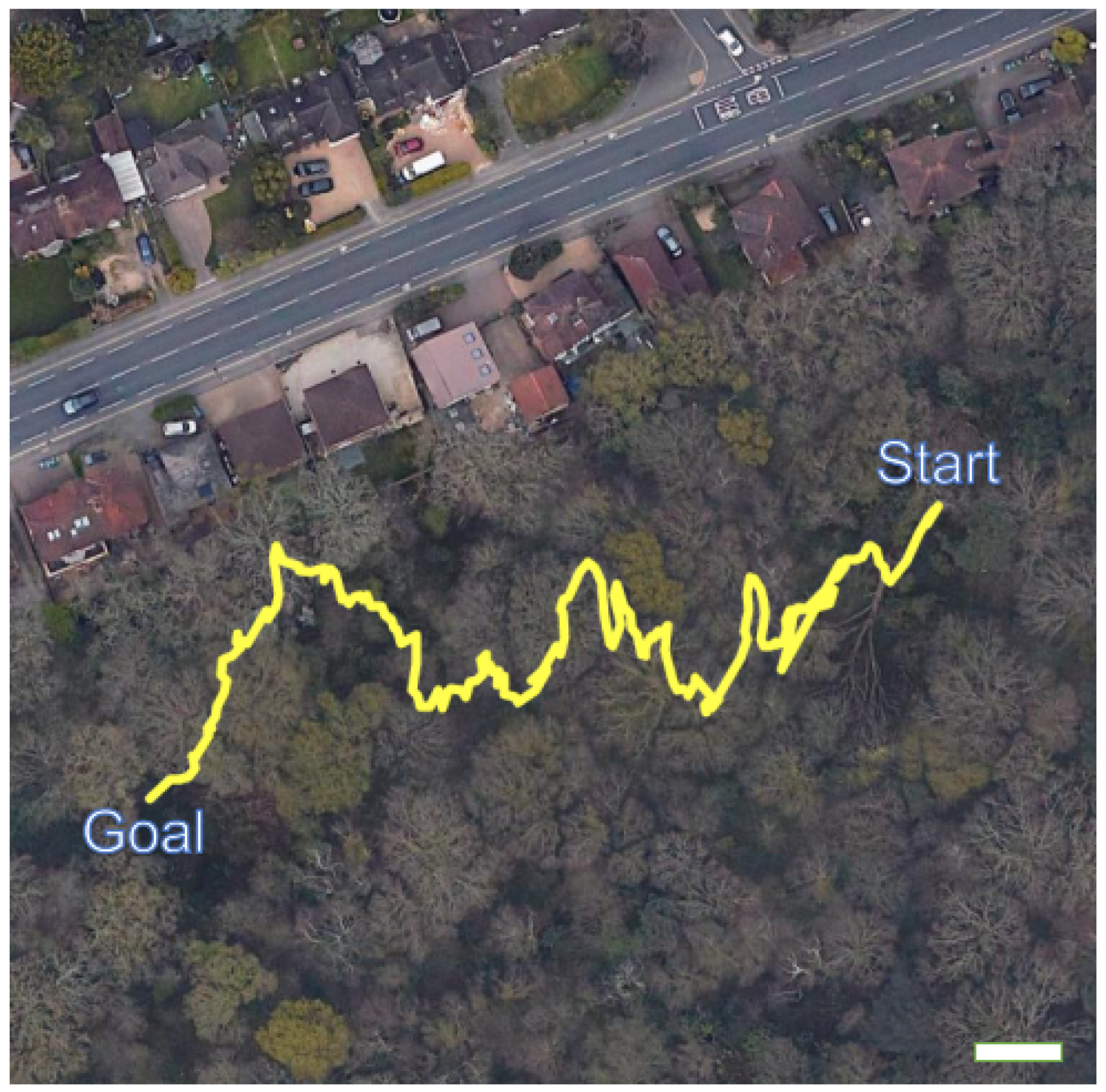
For the forest-trail experiments, the start and goal waypoints were positioned at (5056.1989 N, 124.0732 W) and (5056.1859 N, 124.1515 W), respectively (see Figure 7). The actions GS, TL, TR, GB and waypoint (defined in Section 2) were used to navigate the mobile platform towards the goal waypoint. As the goal was 210 SW of the start location, this bearing was used to rotate the mobile platform to face the goal, using a compass, when the waypoint action was triggered. The GB action was employed by the mobile platform to turn around and attempt to find an alternative path to circumvent large obstacles such as fallen tree trunks. If this action was triggered three times consecutively for the same obstacle, we assumed that there were no traversable paths around the obstacle; consequently, the operator would lift the platform over the obstacle, log the incident, and continue the experiment. The experiment was terminated when the platform reached the goal waypoint.
Forest-trail experiments were performed ten times for each of the MobileNet-V1 and MobileNet-V2 multiclass classification models under several different weather conditions and times of day (see details on the environmental conditions in Table A6 of Appendix A). Across all the experiments, the platform steered by the MobileNet-V1 and MobileNet-V2 models was able to reach the goal waypoint without sustaining any collisions. In navigating with the MobileNet-V1 model, the platform traversed a mean distance of 120 ± 15 m with a turning rate of 0.24 ± 0.02 (mean ± SD across ten replicates, see Table 3). While the MobileNet-V2 model was also able to successfully navigate the platform, it was less efficient, steering left and right significantly more often (mean turning rate of 0.52 ± 0.07 ; Kruskal–Wallis test, p < 0.001), and accumulating a slightly higher traversed mean distance of 131 ± 10 m to reach the goal. Notably, in all the experiments, irrespective of the classification model employed for navigation, the platform had to be lifted over a large fallen tree that blocked the forest trail, as there were no traversable paths to circumvent the obstacle; the incident occurred once in each replicate.
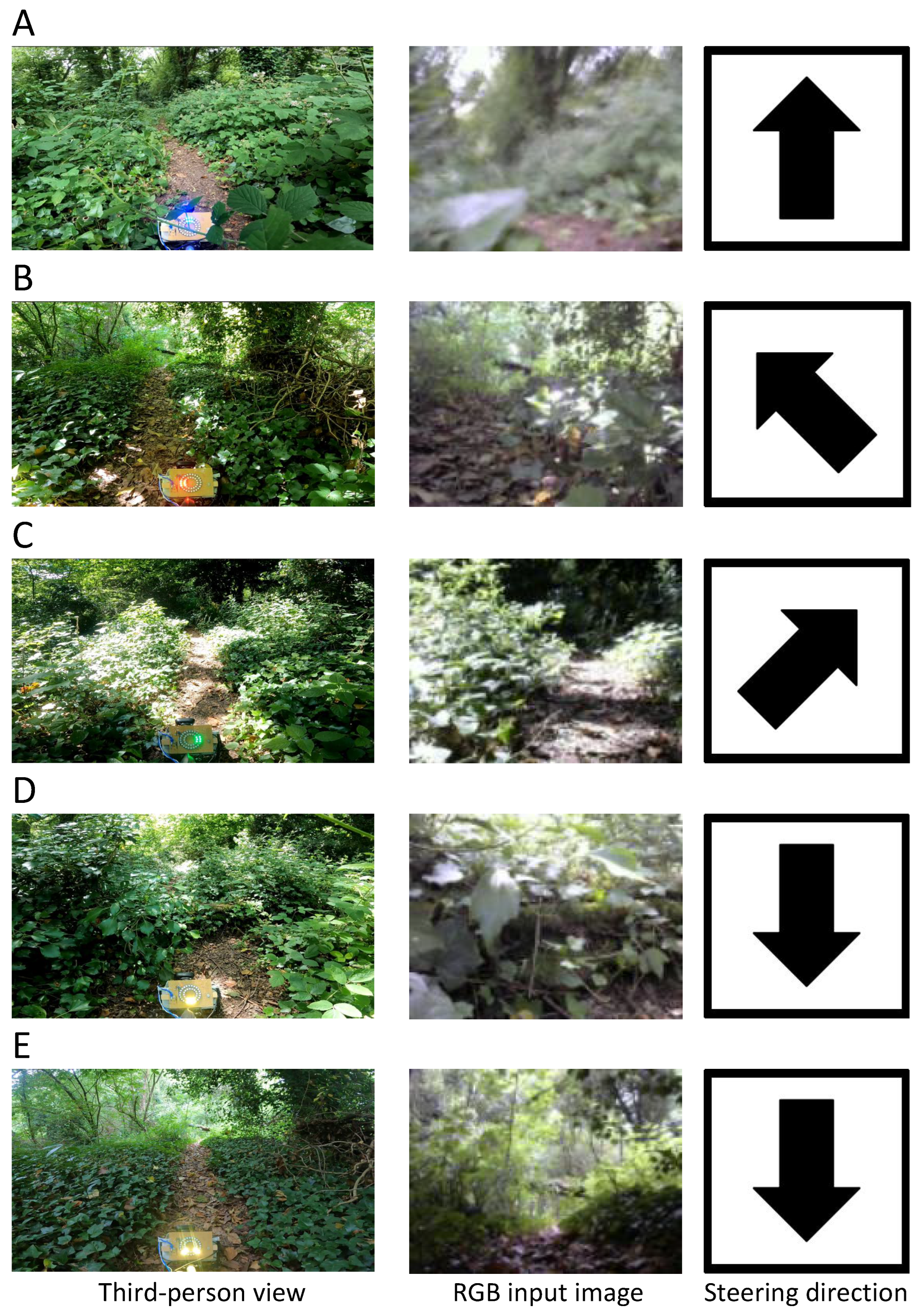
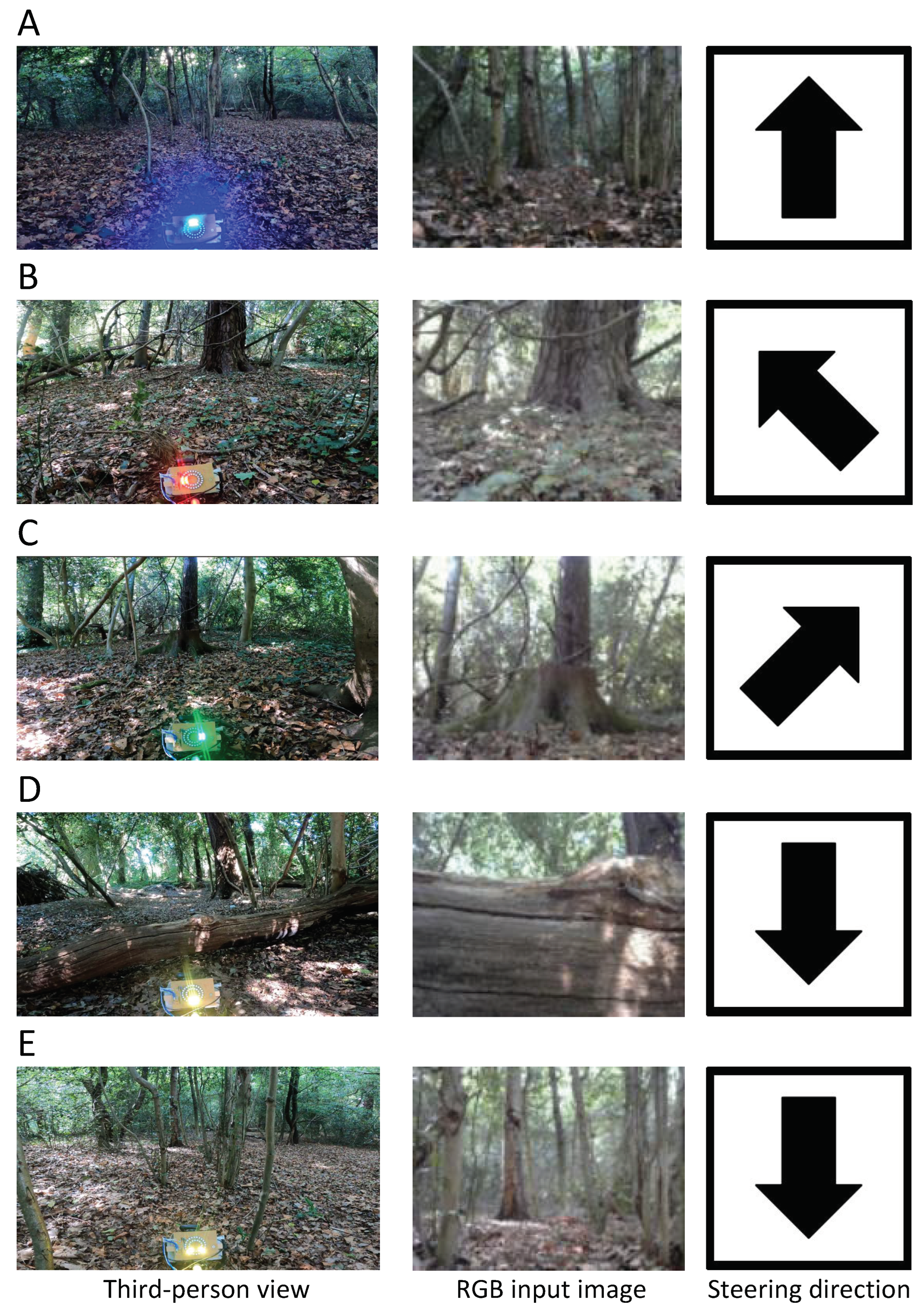
Samples of the navigation performance of the MobileNet-V1 model in different forest scenes are shown in Figure 8 (see more examples in the demonstration video of the Supplementary Material). The platform is accurately directed to perform GS actions when there are no obstacles blocking its path, despite motion blur in the input RGB image (see an example of a clear trail in dense vegetation in Figure 8A). Additionally, the classification model was able to steer the platform towards open spaces to avoid potential collisions (see Figure 8B and C—turning towards the trail in diffuse and high contrast lighting). In scenarios where the robot was facing a close-range obstacle, or large untraversable areas in the distance, the GB action was successfully triggered to avoid potential collisions (see Figure 8D—a fallen tree trunk covered in weeds and moss). Relatedly, the GB action was unnecessarily triggered only once, across all the experiments, when the platform encountered a fallen tree trunk and turned back rather than passing through the small hole between the trunk and the trail (see Figure 8E).
Off-trail forest navigation: Experiments were performed in two unfrequented areas of the Southampton Common woodlands, labeled site A and site B, spanning around 400 m 2 and 200 m 2 of forest, respectively. The two sites included obstacles such as forest litter, standing trees and fallen tree branches. The sites differed in the nature of their environment (see examples in Figure 6B). Site A had a high density of slender trees; it, however, had a very narrow corridor between waypoints for the mobile platform to slide through gaps between trees, requiring only a few turns to reach the destination. By contrast, site B comprised larger trees, tree stumps and fallen tree trunks on an uphill terrain.
Due to the small area of the off-trail environment, a round trip between waypoints was performed for each experiment. The platform was first steered by the navigation algorithm from the start to an intermediate waypoint. On reaching the intermediate waypoint, the platform was oriented back towards the start waypoint to navigate back to it. The experiment was terminated when the platformed reached the start waypoint. In our experiments, the start waypoints were located at (5056.1448 N, 124.0316 W) for site A and (5056.1568 N, 124.0155 W) for site B. Intermediate waypoints for the round trip were at (5056.1533 N, 124.0418 W) for site A and (5056.1666 N, 124.0240 W) for site B. Steering actions GS, TL, TR, GB and waypoint were used to navigate the platform. For the waypoint action, as the goal was always visible to the operator, the waypoint direction was updated through visual observation.
The off-trail experiments were performed ten times for each of the MobileNet-V1 and MobileNet-V2 classification models in several different weather conditions and times of day (see details on environmental conditions in Table A7 of Appendix A). Across all the replicates, for both the classification models, the mobile platform was able to successfully complete the round-trip path without sustaining any collisions, irrespective of the off-trail site, time of day and weather conditions. The platform steered by the MobileNet-V1 model traversed an average distance of 28 ± 5 m (mean ± SD across 20 replicates from both sites A and B) in the round-trip, with a turning rate of 0.13 ± 0.08 (see Table 4). As with the forest trail experiments, the MobileNet-V2 model was less efficient in navigation, accumulating a higher average distance of 33 ± 7 m to complete the round trip, and requiring a higher turning rate of 0.24 ± 0.08 to avoid obstacles; the turning rate was significantly higher in site B, which comprised a high density of forest vegetation (Kruskal–Wallis test, p < 0.001).
The performance of the MobileNet-V1 model in navigating the off-trail areas of the forest is illustrated with some examples in Figure 9 (see more examples in the demonstration video of the Supplementary Material). Despite low lighting conditions, the mobile platform was successfully steered between the narrow space among slender trees (see Figure 9A). It was able to avoid obstacles with a sequence of turning actions (see examples in Figure 9B,C of the platform avoiding a standing tree and tree stump). Moreover, to avoid potential collisions, the GB action was accurately triggered (see Figure 9D of a long fallen tree trunk). Finally, as with the forest-trail experiments, the GB action was unnecessarily triggered only once when the platform failed to identify a narrow gap between two slender trees that it could be pushed through (see Figure 9E).

4. Discussion

In this study, we have implemented a low-viewpoint navigation algorithm for inexpensive small-sized mobile platforms navigating forest environments. For navigation, an end-to-end learning model was trained to predict steering directions from RGB images of a monocular camera mounted on the mobile platform to direct the platform towards open traversable areas of the forest, while avoiding obstacles. A multi-sensor mobile platform was used to collect training data in a forest environment, totaling almost 30,000 low-viewpoint RGB images and the corresponding rotary encoder data. We trained four state-of-the-art lightweight convolution neural networks—DenseNet-121, MobileNet-V1, MobileNet-V2 and NASNetMobile—for multiclass classification of steering actions for RGB images. From the four models, the MobileNet-V1 and MobileNet-V2 were selected for field experiments due to their high accuracy and runtime performance. Our navigation algorithms were extensively tested in real-world forests under several different weather conditions and times of day. In field experiments, using 128 × 96 resolution monocular RGB images, the mobile platform was able to successfully traverse a total of over 3 km of forest terrain comprising small shrubs, dense bushes, tall grass, fallen branches, fallen tree trunks, ditches, small mounds and standing trees.
The developed multiclass classification model solely relies on appearance-based information for navigation. The addition of geometry-based information may potentially provide for a better discrimination of obstacles (e.g., small close-range obstacles vs. large obstacles in the distance) with similar visual features, and consequently enable more accurate steering actions. Geometry and appearance-based information have been successfully combined in few previous studies on end-to-end learning. For example, LiDAR sensor data have been integrated with RGB images from a camera as combined inputs for navigation in indoor environments [32,36]. Our classification models may be easily extended with the addition of geometry-based information. Moreover, for low-cost platforms, depth prediction models may be employed instead of expensive depth sensors such as LiDAR (e.g., see our previous study on low-viewpoint depth prediction models for forest environments [64]).
Rovers operating in a forest are required to make safe and accurate steering decisions on a priori unknown and dynamically changing forest terrain. Therefore, a representation of the confidence of the predicted steering actions is essential for the navigation system [65]. In our classification model, the distribution of the activation of the steering output neurons may be used to approximate the uncertainty in the selected action. More principled approaches such as Gaussian process models and Bayesian deep neural networks appear promising, but computationally expensive, to infer the uncertainty in steering directions, and consequently plan safe paths for the rover (e.g., [66,67]). Finally, hardware or behavior-based solutions (e.g., see [68,69]), to nudge and probe obstacles such as grass and dense bushes, may be integrated onto the rover platform to actively reduce the uncertainty in scene understanding.
The training data for our multiclass steering classification models are captured using a mobile platform steered by an operator walking through the forest. Consequently, the operator’s decisions on what obstacles may be overcome (e.g., pushing through grass, or rolling over a small fallen branch) will be distilled into the navigation algorithm of the rover. However, the training data for the steering classification models may be generalized to rovers with more advanced locomotion capabilities. Obstacles that could be overcome by a rover with better climbing ability than assumed by the operator will only occupy the area at the lower edge of the image frame. Such frames may be identified with image processing to automatically remove them from the training or relabel them with texture discrimination filters as compliant obstacles that may be successfully pushed through.
The aim of our study was to investigate the feasibility of using end-to-end learning for steering a small-sized platform at a low viewpoint through the forest. For our field experiments, coarse steering actions of turn-left and turn-right were employed for navigation. However, our approach could easily be extended to directly output wheel speeds to a rover, using techniques such as deep reinforcement learning [47,70]. Moreover, for the training of such a rover controller, the captured RGB images could be automatically labeled with a finer resolution of velocity vectors using the rotary encoder data from our mobile platform.

5. Conclusions

In this study, a mobile platform running our navigation algorithm is pushed by an operator, guided by the displayed steering directions onboard the platform. Such an approach enabled us to focus solely on the challenges of forest navigation without the additional constraints of field experiments with physical rovers, not to mention the enormous challenges in designing a portable high-endurance and low-cost off-road rover. However, our approach to navigation may be employed on real rovers. For navigation, the monocular camera on our mobile platform is mounted 18 cm over the ground, consistent with the low viewpoint of off-road small-sized rovers (e.g., see rovers deployed in [21,71,72]). Moreover, our navigation algorithm is robust to blurred images from the platform’s movement as well as shadows, high-contrast lighting and low-lighting conditions. Arguably, our approach to forest navigation for small-sized rovers is promising for physical validation on real rovers.

Supplementary Materials

A demonstration video of our field experiments, performed on a sunny day in the morning, is available at https://www.youtube.com/watch?v=UbY4i1xodx8, accessed on 25 November 2022.

Author Contributions

Conceptualization, C.N., D.T. and K.-P.Z.; methodology, C.N., D.T. and K.-P.Z.; software, C.N.; validation, C.N.; investigation, C.N.; resources, C.N., D.T. and K.-P.Z.; data curation, C.N.; writing—original draft preparation, C.N. and D.T.; writing—review and editing, C.N., D.T. and K.-P.Z.; visualization, C.N.; supervision, D.T. and K.-P.Z.; project administration, C.N.; All authors have read and agreed to the published version of the manuscript.

Funding

This research received no external funding.

Institutional Review Board Statement

Not applicable.

Informed Consent Statement

Not applicable.

Data Availability Statement

Not applicable.

Acknowledgments

The authors acknowledge the use of the IRIDIS High Performance Computing Facility, and the associated support services at the University of Southampton, in the completion of this work.

Conflicts of Interest

The authors declare no conflict of interest.

Appendix A

Table A1. A comparison of studies on steering prediction following end-to-end learning, with the weight of the rover and the approximate cost of the sensors required for navigation. Terrains are categorized in ascending order of difficulty. Sensor costs were obtained from vendor sites, where available. Dashed lines indicate the corresponding data was unavailable.
ReferenceEnvironmentsApproximate Sensors Cost (GBP)Weight of Rovers (kg)
5: Highways and traffic road
[44]Racing track on traffic road2101231
[40]Highways (sunlight facing the camera, high contrast sunlight, shadows, covered in snow)14,0001579
[37]Traffic road380-
[38]Traffic road and walkways in parks8400-
4: Off-road on cemented paths, short grass, pebbles, dirt and dry leaves
[41]Off-road racing track30022
[42]Mowed and short grass off-trail38035
[43]Cemented and off-road trails with pebbles, dirt, sand, grass and fallen leaves, with few obstacles550035
3: Sidewalks and walkways in urban environment
[47]Static environments: walkways in office areas, laboratory space and corridors; dynamic environments: sidewalks among crowds.35512
[45]Paved road cemented on grass80050
[46]Mowed lawn, short grass, and trees in urban environment100017
[53]Sidewalks outside malls and office buildings5500-
[48]Walkways in neighborhoods and parks605
[39]Parking lots, city roads and sidewalks6062
[25]Corridor indoors and stone trail outdoors40030
2: Factory floor and cluttered room indoors
[49]Factory floor23013
[34]Corridor indoors with few obstacles3407
[35]Corridor, kitchen and laboratory space6002
[36]Cluttered corridor indoors7000-
[50]Cluttered maze-like indoor environment40007
[51]Room with few obstacles1004
[52]Corridor indoors40055
1: Colored track indoors
[32]Colored track indoors with few obstacles3202
[33]Colored track indoors30-
[31]Colored tracks indoors and outdoors, and room with few obstacles50-
[30]Colored track indoors62
Table A2. Dataset of RGB images for the multiclass classifier. The RGB images of the dataset were labeled go straight (GS), turn left (TL), turn right (TR) and go back (GB) using the wheel encoder data of the mobile platform. Subsequently, subsets of the dataset were used for training (70%), validation (15%) and testing (15%) the multiclass classifier models.
DataGBGSTLTRTotal
Training set200513,6972122246620,290
Validation set43229394585334362
Testing set43129374575284353
Table A3. Performance of the MobileNet-V1 models trained on different input image resolutions. Accuracy and log-loss were aggregated across 4353 images (testing set).
Input Image ResolutionsAccuracyLog-LossModel Size
32 × 320.331.3816 MB
64 × 640.781.0022 MB
128 × 960.960.1939 MB
128 × 1280.960.2247 MB
Table A4. The 5-fold cross validation for 224 × 224 resolution images among the DenseNet-121, MobileNet-V1, MobileNet-V2 and NASNetMobile models.
Densenet-121MobileNet-V1MobileNet-V2NASNetMobile
Accuracy0.9780.9800.9700.958
Log-loss0.1160.1180.1540.178
Precision (macro avg)0.9740.9740.9640.942
Precision (weighted avg)0.9780.9800.9700.958
Recall (macro avg)0.9640.9620.9520.944
Recall (weighted avg)0.9780.9800.9700.958
f1-score (macro avg)0.9680.9700.9580.942
f1-score (weighted avg)0.9780.9800.9700.958
Table A5. The 5-fold cross validation for 128 × 96 resolution image between the MobileNet-V1 and MobileNet-V2 models.
MobileNet-V1MobileNet-V2
Accuracy0.9500.896
Log-loss0.2280.448
Precision (macro avg)0.9380.862
Precision (weighted avg)0.9520.912
Recall (macro avg)0.9300.880
Recall (weighted avg)0.9500.896
f1-score (macro avg)0.9340.860
f1-score (weighted avg)0.9500.900
Table A6. The times of day and weather conditions for all of ten experiments employing the MobileNet-V1 and MobileNet-V2 models in the forest trail environment in the Southampton Common woodlands.
MobileNet-V1MobileNet-V2
TrialTimes of DayWeather ConditionsTimes of DayWeather Conditions
Run 1AfternoonCloudyForenoonScattered clouds
Run 2AfternoonScattered cloudsMiddayPartly sunny
Run 3Late afternoonPart cloudyAfternoonMostly clear
Run 4Late afternoonClearAfternoonPartly sunny
Run 5Late afternoonMostly clearForenoonPartly sunny
Run 6ForenoonPartly sunnyMiddaySunny
Run 7ForenoonClearAfternoonSunny
Run 8ForenoonScattered cloudsAfternoonClear
Run 9MiddayMostly clearMorning,Partly sunny
Run 10MiddayPart cloudyAfternoonScattered clouds
Table A7. The times of day and weather conditions for all of ten experiments employing MobileNet-V1 and MobileNet-V2 models in site A and site B of off-trail environments in the Southampton Common woodlands.
MobileNet-V1MobileNet-V2
TrialTimes of DayWeather ConditionsTimes of DayWeather Conditions
Site A
Run 1ForenoonSunnyMorningClear
Run 2ForenoonSunny, mostly shadowMorningPartly sunny
Run 3MiddayPartly sunnyMorningMostly clear
Run 4MiddayPartly sunny, mostly shadowAfternoonMostly clear
Run 5AfternoonMostly clearAfternoonScattered clouds
Run 6AfternoonClearNear sunsetPart cloudy
Run 7AfternoonScattered cloudsNear sunsetClear
Run 8MiddayPartly cloudyNear sunsetScattered clouds
Run 9AfternoonCloudyEveningCloudy
Run 10ForenoonSunny, mostly shadowEveningCloudy
Site B
Run 1MiddaySunnyMorningClear
Run 2MiddaySunny, Sun diffuseForenoonPartly sunny
Run 3MiddaySunnyForenoonSunny
Run 4AfternoonPartly sunny, Sun diffuseMiddaySunny
Run 5AfternoonMostly clear, Sun diffuseNoonBright
Run 6ForenoonCloudyNoonSunny
Run 7ForenoonScattered cloudsAfternoonSunny
Run 8AfternoonClearAfternoonSunny
Run 9MiddayMostly clearSunsetClear
Run 10MiddayClear, Partly sunnySunsetMostly clear

References

  1. Muller, E.; Kushlin, A.; Linhares-Juvenal, T.; Muchoney, D.; Wertz-Kanounnikoff, S.; Henderson-Howat, D. The State of the World’s Forests: Forest Pathways to Sustainable Development; FAO: Rome, Italy, 2018. [CrossRef] [Green Version]
  2. Seymour, F. Seeing the forests as well as the (trillion) trees in corporate climate strategies. One Earth 2020, 2, 390–393. [Google Scholar] [CrossRef]
  3. Santini, A.; Ghelardini, L.; De Pace, C.; Desprez-Loustau, M.L.; Capretti, P.; Chandelier, A.; Cech, T.; Chira, D.; Diamandis, S.; Gaitniekis, T.; et al. Biogeographical patterns and determinants of invasion by forest pathogens in Europe. New Phytol. 2013, 197, 238–250. [Google Scholar] [CrossRef] [PubMed] [Green Version]
  4. Herold, M.; Carter, S.; Avitabile, V.; Espejo, A.B.; Jonckheere, I.; Lucas, R.; McRoberts, R.E.; Næsset, E.; Nightingale, J.; Petersen, R.; et al. The role and need for space-based forest biomass-related measurements in environmental management and policy. Surv. Geophys. 2019, 40, 757–778. [Google Scholar] [CrossRef] [Green Version]
  5. Zhang, J.; Hu, J.; Lian, J.; Fan, Z.; Ouyang, X.; Ye, W. Seeing the forest from drones: Testing the potential of lightweight drones as a tool for long-term forest monitoring. Biol. Conserv. 2016, 198, 60–69. [Google Scholar] [CrossRef]
  6. Tarapore, D.; Groß, R.; Zauner, K.P. Sparse Robot Swarms: Moving Swarms to Real-World Applications. Front. Robot. AI 2020, 7, 83. [Google Scholar] [CrossRef] [PubMed]
  7. Hill, L.; Jones, G.; Atkinson, N.; Hector, A.; Hemery, G.; Brown, N. The £15 billion cost of ash dieback in Britain. Curr. Biol. 2019, 29, R315–R316. [Google Scholar] [CrossRef] [PubMed]
  8. Couceiro, M.S.; Portugal, D.; Ferreira, J.F.; Rocha, R.P. SEMFIRE: Towards a new generation of forestry maintenance multi-robot systems. In Proceedings of the 2019 IEEE/SICE International Symposium on System Integration (SII), Paris, France, 14–16 January 2019; pp. 270–276. [Google Scholar] [CrossRef]
  9. Batey, T. Soil compaction and soil management—A review. Soil Use Manag. 2009, 25, 335–345. [Google Scholar] [CrossRef]
  10. Yang, G.Z.; Bellingham, J.; Dupont, P.E.; Fischer, P.; Floridi, L.; Full, R.; Jacobstein, N.; Kumar, V.; McNutt, M.; Merrifield, R.; et al. The grand challenges of Science Robotics. Sci. Robot. 2018, 3, eaar7650. [Google Scholar] [CrossRef]
  11. Niu, C.; Tarapore, D.; Zauner, K.P. Low-Viewpoint Forest Depth Dataset for Sparse Rover Swarms. In Proceedings of the IEEE/RSJ International Conference on Intelligent Robots and Systems (IROS), Las Vegas, NV, USA, 25–29 October 2020; pp. 8035–8040. [Google Scholar] [CrossRef]
  12. Da Silva, D.Q.; dos Santos, F.N.; Sousa, A.J.; Filipe, V.; Boaventura-Cunha, J. Unimodal and Multimodal Perception for Forest Management: Review and Dataset. Computation 2021, 9, 127. [Google Scholar] [CrossRef]
  13. Ostafew, C.J.; Schoellig, A.P.; Barfoot, T.D. Robust Constrained Learning-based NMPC enabling reliable mobile robot path tracking. Int. J. Robot. Res. 2016, 35, 1547–1563. [Google Scholar] [CrossRef]
  14. Papadakis, P. Terrain traversability analysis methods for unmanned ground vehicles: A survey. Eng. Appl. Artif. Intell. 2013, 26, 1373–1385. [Google Scholar] [CrossRef] [Green Version]
  15. Borges, P.; Peynot, T.; Liang, S.; Arain, B.; Wildie, M.; Minareci, M.; Lichman, S.; Samvedi, G.; Sa, I.; Hudson, N.; et al. A Survey on Terrain Traversability Analysis for Autonomous Ground Vehicles: Methods, Sensors, and Challenges. Field Robot. 2022, 2, 1567–1627. [Google Scholar] [CrossRef]
  16. Krotkov, E.; Fish, S.; Jackel, L.; McBride, B.; Perschbacher, M.; Pippine, J. The DARPA PerceptOR evaluation experiments. Auton. Robot. 2007, 22, 19–35. [Google Scholar] [CrossRef]
  17. Jackel, L.D.; Krotkov, E.; Perschbacher, M.; Pippine, J.; Sullivan, C. The DARPA LAGR program: Goals, challenges, methodology, and phase I results. J. Field Robot. 2006, 23, 945–973. [Google Scholar] [CrossRef]
  18. Ugenti, A.; Vulpi, F.; Domínguez, R.; Cordes, F.; Milella, A.; Reina, G. On the role of feature and signal selection for terrain learning in planetary exploration robots. J. Field Robot. 2022, 39, 355–370. [Google Scholar] [CrossRef]
  19. Lee, H.; Chung, W. A Self-Training Approach-Based Traversability Analysis for Mobile Robots in Urban Environments. In Proceedings of the 2021 IEEE International Conference on Robotics and Automation (ICRA), Xi’an, China, 30 May–5 June 2021; pp. 3389–3394. [Google Scholar] [CrossRef]
  20. Milella, A.; Reina, G.; Underwood, J. A self-learning framework for statistical ground classification using radar and monocular vision. J. Field Robot. 2015, 32, 20–41. [Google Scholar] [CrossRef]
  21. Sebastian, B.; Ren, H.; Ben-Tzvi, P. Neural network based heterogeneous sensor fusion for robot motion planning. In Proceedings of the 2019 IEEE/RSJ International Conference on Intelligent Robots and Systems (IROS), Macao, China, 4–8 November 2019; pp. 2899–2904. [Google Scholar] [CrossRef]
  22. Peynot, T.; Lui, S.T.; McAllister, R.; Fitch, R.; Sukkarieh, S. Learned stochastic mobility prediction for planning with control uncertainty on unstructured terrain. J. Field Robot. 2014, 31, 969–995. [Google Scholar] [CrossRef] [Green Version]
  23. Ho, K.; Peynot, T.; Sukkarieh, S. Traversability estimation for a planetary rover via experimental kernel learning in a Gaussian Process framework. In Proceedings of the 2013 IEEE International Conference on Robotics and Automation (ICRA), Karlsruhe, Germany, 6–10 May 2013; pp. 3475–3482. [Google Scholar] [CrossRef] [Green Version]
  24. Bjelonic, M.; Kottege, N.; Homberger, T.; Borges, P.; Beckerle, P.; Chli, M. Weaver: Hexapod robot for autonomous navigation on unstructured terrain. J. Field Robot. 2018, 35, 1063–1079. [Google Scholar] [CrossRef]
  25. Ai, B.; Gao, W.; Hsu, D. Deep Visual Navigation under Partial Observability. In Proceedings of the 2022 International Conference on Robotics and Automation (ICRA), Philadelphia, PA, USA, 23–27 May 2022; pp. 9439–9446. [Google Scholar] [CrossRef]
  26. Corke, P.; Paul, R.; Churchill, W.; Newman, P. Dealing with shadows: Capturing intrinsic scene appearance for image-based outdoor localisation. In Proceedings of the 2013 IEEE/RSJ International Conference on Intelligent Robots and Systems, Tokyo, Japan, 3–7 November 2013; pp. 2085–2092. [Google Scholar] [CrossRef]
  27. Ordóñez, F.J.; Roggen, D. Deep Convolutional and LSTM Recurrent Neural Networks for Multimodal Wearable Activity Recognition. Sensors 2016, 16, 115. [Google Scholar] [CrossRef] [Green Version]
  28. Chen, Y.; Cheng, C.; Zhang, Y.; Li, X.; Sun, L. A neural network-based navigation approach for autonomous mobile robot systems. Appl. Sci. 2022, 12, 7796. [Google Scholar] [CrossRef]
  29. Ab Wahab, M.N.; Nefti-Meziani, S.; Atyabi, A. A comparative review on mobile robot path planning: Classical or meta-heuristic methods? Annu. Rev. Control 2020, 50, 233–252. [Google Scholar] [CrossRef]
  30. Bechtel, M.G.; McEllhiney, E.; Kim, M.; Yun, H. Deeppicar: A low-cost deep neural network-based autonomous car. In Proceedings of the 2018 IEEE 24th International Conference on Embedded and Real-Time Computing Systems and Applications (RTCSA), Hakodate, Japan, 28–31 August 2018; pp. 11–21. [Google Scholar] [CrossRef]
  31. Zhang, Y.; Zhao, Y.; Liu, M.; Dong, L.; Kong, L.; Liu, L. Vision-based mobile robot navigation through deep convolutional neural networks and end-to-end learning. In Proceedings of the Applications of Digital Image Processing XL. SPIE, San Diego, CA, USA, 7–10 August 2017; Volume 10396, pp. 404–411. [Google Scholar] [CrossRef]
  32. Kang, I.; Cimurs, R.; Lee, J.H.; Suh, I.H. Fusion drive: End-to-end multi modal sensor fusion for guided low-cost autonomous vehicle. In Proceedings of the 2020 17th International Conference on Ubiquitous Robots (UR), Kyoto, Japan, 22–26 June 2020; pp. 421–428. [Google Scholar] [CrossRef]
  33. Simmons, B.; Adwani, P.; Pham, H.; Alhuthaifi, Y.; Wolek, A. Training a remote-control car to autonomously lane-follow using end-to-end neural networks. In Proceedings of the 2019 53rd Annual Conference on Information Sciences and Systems (CISS), Baltimore, MD, USA, 20–22 March 2019; pp. 1–6. [Google Scholar] [CrossRef]
  34. Kim, Y.H.; Jang, J.I.; Yun, S. End-to-end deep learning for autonomous navigation of mobile robot. In Proceedings of the 2018 IEEE International Conference on Consumer Electronics (ICCE), Las Vegas, NV, USA, Jeju, Republic of Korea, 12–14 January 2018; pp. 1–6. [Google Scholar] [CrossRef]
  35. Zhou, X.; Gao, Y.; Guan, L. Towards goal-directed navigation through combining learning based global and local planners. Sensors 2019, 19, 176. [Google Scholar] [CrossRef] [Green Version]
  36. Patel, N.; Choromanska, A.; Krishnamurthy, P.; Khorrami, F. A deep learning gated architecture for UGV navigation robust to sensor failures. Robot. Auton. Syst. 2019, 116, 80–97. [Google Scholar] [CrossRef]
  37. Curiel-Ramirez, L.A.; Ramirez-Mendoza, R.A.; Carrera, G.; Izquierdo-Reyes, J.; Bustamante-Bello, M.R. Towards of a modular framework for semi-autonomous driving assistance systems. Int. J. Interact. Des. Manuf. (IJIDeM) 2019, 13, 111–120. [Google Scholar] [CrossRef]
  38. Seiya, S.; Carballo, A.; Takeuchi, E.; Miyajima, C.; Takeda, K. End-to-End Navigation with Branch Turning Support Using Convolutional Neural Network. In Proceedings of the 2018 IEEE International Conference on Robotics and Biomimetics (ROBIO), Kuala Lumpur, Malaysia, 12–15 December 2018; pp. 499–506. [Google Scholar] [CrossRef]
  39. Zhu, K.; Chen, W.; Zhang, W.; Song, R.; Li, Y. Autonomous robot navigation based on multi-camera perception. In Proceedings of the 2020 IEEE/RSJ International Conference on Intelligent Robots and Systems (IROS), Las Vegas, NV, USA, 25–29 October 2020; pp. 5879–5885. [Google Scholar] [CrossRef]
  40. Maanpää, J.; Taher, J.; Manninen, P.; Pakola, L.; Melekhov, I.; Hyyppä, J. Multimodal end-to-end learning for autonomous steering in adverse road and weather conditions. In Proceedings of the 2020 25th International Conference on Pattern Recognition (ICPR), Milan, Italy, 10–15 January 2021; pp. 699–706. [Google Scholar] [CrossRef]
  41. Pan, Y.; Cheng, C.A.; Saigol, K.; Lee, K.; Yan, X.; Theodorou, E.A.; Boots, B. Imitation learning for agile autonomous driving. Int. J. Robot. Res. 2020, 39, 286–302. [Google Scholar] [CrossRef]
  42. Hensley, C.; Marshall, M. Off-Road Navigation With End-to-end Imitation Learning for Continuously Parameterized Control. In Proceedings of the SoutheastCon 2022, Mobile, AL, USA, 26 March–3 April 2022; pp. 591–597. [Google Scholar] [CrossRef]
  43. Karnan, H.; Sikand, K.S.; Atreya, P.; Rabiee, S.; Xiao, X.; Warnell, G.; Stone, P.; Biswas, J. VI-IKD: High-Speed Accurate Off-Road Navigation using Learned Visual-Inertial Inverse Kinodynamics. arXiv 2022, arXiv:2203.15983. [Google Scholar] [CrossRef]
  44. Navarro, A.; Joerdening, J.; Khalil, R.; Brown, A.; Asher, Z. Development of an autonomous vehicle control strategy using a single camera and deep neural networks; Technical report; SAE Technical Paper, 2018. [Google Scholar] [CrossRef]
  45. Amado, J.A.D.; Gomes, I.P.; Amaro, J.; Wolf, D.F.; Osório, F.S. End-to-end deep learning applied in autonomous navigation using multi-cameras system with RGB and depth images. In Proceedings of the 2019 IEEE Intelligent Vehicles Symposium (IV), Paris, France, 9–12 June 2019; pp. 1626–1631. [Google Scholar] [CrossRef]
  46. Kahn, G.; Abbeel, P.; Levine, S. BADGR: An Autonomous Self-Supervised Learning-Based Navigation System. IEEE Robot. Autom. Lett. 2021, 6, 1312–1319. [Google Scholar] [CrossRef]
  47. Wu, K.; Abolfazli Esfahani, M.; Yuan, S.; Wang, H. Learn to Steer through Deep Reinforcement Learning. Sensors 2018, 18, 3650. [Google Scholar] [CrossRef] [Green Version]
  48. Codevilla, F.; Müller, M.; López, A.; Koltun, V.; Dosovitskiy, A. End-to-end driving via conditional imitation learning. In Proceedings of the 2018 IEEE International Conference on Robotics and Automation (ICRA), Brisbane, Australia, 21–25 May 2018; pp. 4693–4700. [Google Scholar] [CrossRef] [Green Version]
  49. Li, C.H.G.; Zhou, L.P.; Chao, Y.H. Self-balancing two-wheeled robot featuring intelligent end-to-end deep visual-steering. IEEE/ASME Trans. Mechatron. 2020, 26, 2263–2273. [Google Scholar] [CrossRef]
  50. Pfeiffer, M.; Schaeuble, M.; Nieto, J.; Siegwart, R.; Cadena, C. From perception to decision: A data-driven approach to end-to-end motion planning for autonomous ground robots. In Proceedings of the 2017 IEEE International Conference on Robotics and Automation (ICRA), Singapore, 29 May–3 June 2017; pp. 1527–1533. [Google Scholar] [CrossRef]
  51. Liu, C.; Zheng, B.; Wang, C.; Zhao, Y.; Fu, S.; Li, H. CNN-based vision model for obstacle avoidance of mobile robot. In Proceedings of the MATEC Web of Conferences, Wuhan, China, 26–27 March 2016; EDP Sciences: Les Ulis, France, 2017; Volume 139, p. 00007. [Google Scholar] [CrossRef]
  52. Li, C.H.G.; Zhou, L.P. Training end-to-end steering of a self-balancing mobile robot based on RGB-D image and deep ConvNet. In Proceedings of the 2020 IEEE/ASME International Conference on Advanced Intelligent Mechatronics (AIM), Boston, MA, USA, 6–9 July 2020; pp. 898–903. [Google Scholar] [CrossRef]
  53. Carballo, A.; Seiya, S.; Lambert, J.; Darweesh, H.; Narksri, P.; Morales, L.Y.; Akai, N.; Takeuchi, E.; Takeda, K. End-to-end autonomous mobile robot navigation with model-based system support. J. Robot. Mechatronics 2018, 30, 563–583. [Google Scholar] [CrossRef]
  54. Huang, G.; Liu, Z.; Van Der Maaten, L.; Weinberger, K.Q. Densely connected convolutional networks. In Proceedings of the IEEE Conference on Computer Vision and Pattern Recognition, Honolulu, HI, USA, 21–26 July 2017; pp. 4700–4708. [Google Scholar] [CrossRef] [Green Version]
  55. Howard, A.G.; Zhu, M.; Chen, B.; Kalenichenko, D.; Wang, W.; Weyand, T.; Andreetto, M.; Adam, H. Mobilenets: Efficient convolutional neural networks for mobile vision applications. arXiv 2017, arXiv:1704.04861. [Google Scholar] [CrossRef]
  56. Sandler, M.; Howard, A.; Zhu, M.; Zhmoginov, A.; Chen, L.C. MobileNetV2: Inverted residuals and linear bottlenecks. In Proceedings of the IEEE Conference on Computer Vision and Pattern Recognition, Salt Lake City, UT, USA, 18–23 June 2018; pp. 4510–4520. [Google Scholar] [CrossRef] [Green Version]
  57. Zoph, B.; Vasudevan, V.; Shlens, J.; Le, Q.V. Learning transferable architectures for scalable image recognition. In Proceedings of the IEEE Conference on Computer Vision and Pattern Recognition, Salt Lake City, UT, USA, 18–23 June 2018; pp. 8697–8710. [Google Scholar] [CrossRef] [Green Version]
  58. Krizhevsky, A.; Sutskever, I.; Hinton, G.E. Imagenet classification with deep convolutional neural networks. Adv. Neural Inf. Process. Syst. 2012, 25, 1097–1105. [Google Scholar] [CrossRef] [Green Version]
  59. Srivastava, N.; Hinton, G.; Krizhevsky, A.; Sutskever, I.; Salakhutdinov, R. Dropout: A simple way to prevent neural networks from overfitting. J. Mach. Learn. Res. 2014, 15, 1929–1958. [Google Scholar]
  60. Bishop, C.M.; Nasrabadi, N.M. Pattern Recognition and Machine Learning; Springer: New York, NY, USA, 2006. [Google Scholar]
  61. Abadi, M.; Barham, P.; Chen, J.; Chen, Z.; Davis, A.; Dean, J.; Devin, M.; Ghemawat, S.; Irving, G.; Isard, M.; et al. Tensorflow: A system for large-scale machine learning. In Proceedings of the 12th USENIX Symposium on Operating Systems Design and Implementation (OSDI 16), Savannah, GA, USA, 2–4 November 2016; pp. 265–283. [Google Scholar] [CrossRef]
  62. Gulli, A.; Pal, S. Deep Learning with Keras; Packt Publishing Ltd.: Birmingham, UK, 2017. [Google Scholar]
  63. Louis, M.S.; Azad, Z.; Delshadtehrani, L.; Gupta, S.; Warden, P.; Reddi, V.J.; Joshi, A. Towards Deep Learning using TensorFlow Lite on RISC-V. In Proceedings of the 3rd Workshop on Computer Architecture Research with RISC-V (CARRV), Phoenix, AZ, USA, 22 June 2019; Volume 1, p. 6. [Google Scholar] [CrossRef]
  64. Niu, C.; Newlands, C.; Zauner, K.P.; Tarapore, D. An embarrassingly simple approach for visual navigation of forest environments. Front. Robot. AI. 2022; Under review. [Google Scholar]
  65. Amini, A.; Paull, L.; Balch, T.; Karaman, S.; Rus, D. Learning steering bounds for parallel autonomous systems. In Proceedings of the 2018 IEEE International Conference on Robotics and Automation (ICRA), Brisbane, Australia, 21–25 May 2018; pp. 4717–4724. [Google Scholar] [CrossRef] [Green Version]
  66. Gregory, J.M.; Warnell, G.; Fink, J.; Gupta, S.K. Improving trajectory tracking accuracy for faster and safer autonomous navigation of ground vehicles in off-road settings. In Proceedings of the 2021 IEEE International Symposium on Safety, Security, and Rescue Robotics (SSRR), New York, NY, USA, 25–27 October 2021; pp. 204–209. [Google Scholar] [CrossRef]
  67. Hubschneider, C.; Hutmacher, R.; Zöllner, J.M. Calibrating uncertainty models for steering angle estimation. In Proceedings of the 2019 IEEE Intelligent Transportation Systems Conference (ITSC), Auckland, New Zealand, 27–30 October 2019; pp. 1511–1518. [Google Scholar] [CrossRef]
  68. Haddeler, G.; Chuah, M.Y.M.; You, Y.; Chan, J.; Adiwahono, A.H.; Yau, W.Y.; Chew, C.M. Traversability analysis with vision and terrain probing for safe legged robot navigation. arXiv 2022, arXiv:2209.00334. [Google Scholar] [CrossRef] [PubMed]
  69. Armbrust, C.; Braun, T.; Föhst, T.; Proetzsch, M.; Renner, A.; Schäfer, B.H.; Berns, K. RAVON: The robust autonomous vehicle for off-road navigation. In Using Robots in Hazardous Environments; Elsevier: Amsterdam, The Netherlands, 2011; pp. 353–396. [Google Scholar] [CrossRef] [Green Version]
  70. Tai, L.; Paolo, G.; Liu, M. Virtual-to-real deep reinforcement learning: Continuous control of mobile robots for mapless navigation. In Proceedings of the 2017 IEEE/RSJ International Conference on Intelligent Robots and Systems (IROS), Vancouver, DC, Canada, 24–28 September 2017; pp. 31–36. [Google Scholar] [CrossRef] [Green Version]
  71. Tang, Y.; Cai, J.; Chen, M.; Yan, X.; Xie, Y. An autonomous exploration algorithm using environment-robot interacted traversability analysis. In Proceedings of the 2019 IEEE/RSJ International Conference on Intelligent Robots and Systems (IROS), Macao, China, 4–8 November 2019; pp. 4885–4890. [Google Scholar] [CrossRef]
  72. Murphy, L.; Martin, S.; Corke, P. Creating and using probabilistic costmaps from vehicle experience. In Proceedings of the 2012 IEEE/RSJ International Conference on Intelligent Robots and Systems, Vilamoura-Algarve, Portugal, 7–12 October 2012; pp. 4689–4694. [Google Scholar] [CrossRef]
Figure 1. The relationship between the navigation sensor cost, rover weight and terrain difficulty in studies using end-to-end learning. Terrains are categorized in ascending order of difficulty as follows: 1. colored track indoors; 2. corridor and rooms indoors; 3. sidewalks and walkways in urban environment; 4. off-road on cemented paths, short grass, pebbles, dirt and dry leaves; and 5. highways and traffic roads, forest environment—dense bushes, tall grass, fallen branches, fallen tree trunks, standing trees, small mounds and ditches. Importantly, to the best of our knowledge, none of the studies have investigated end-to-end learning for navigation in forest environments. For details on environments in the referenced studies, see Table A1 in Appendix A [30,31,32,33,34,35,36,37,38,39,40,41,42,43,44,45,46,47,48,49,50,51,52,53].
Forests 14 00268 g001
Figure 2. Architecture of multiclass classification models for end-to-end learning. The input RGB image is first fed into lightweight convolutional neural networks—one of DenseNet-121, MobileNet, MobileNet-V2 and NASNetMobile—that are pre-trained on ImageNet. Outputs of the convolutional neural networks are flattened and input into three fully connected (FC) layers. The first two layers utilize a rectified linear unit activation (ReLU). A softmax activation is utilized by the final layer for steering direction selection—one of go straight (GS), turn left (TL), turn right (TR), and go back (GB). Batch normalization (BN) and dropout operations were employed after each FC layer to avoid overfitting the training data.
Forests 14 00268 g002
Figure 3. Confusion matrix of DenseNet-121, MobileNet-V1, MobileNet-V2 and NASNetMobile multiclass classification models for the go straight (GS), turn left (TL), turn right (TR) and go back (GB) steering actions, with input RGB images of resolutions 224 × 224.
Forests 14 00268 g003
Figure 4. Confusion matrix of MobileNet-V1 and MobileNet-V2 models for the go straight (GS), turn left (TL), turn right (TR) and go back (GB) steering actions for input image resolutions of 128 × 96.
Forests 14 00268 g004
Figure 5. The two-wheeled mobile platform with an operator. The platform is equipped with a Logitech C270 camera, two NeoPixel rings, a Raspberry Pi 4, a Raspberry Pi HDMI display, a GoPro camera, and a portable power bank. RGB images captured by the Logitech camera are transmitted to the Raspberry Pi 4, to predict steering directions. The resulting steering actions are displayed on the NeoPixel LED rings. Note that the platform is also used for data collection, where the Logitech camera is replaced with an Intel Realsense D435i camera, and the data including RGB images and rotary encoder counts are synchronously stored on a laptop via a USB connection.
Forests 14 00268 g005
Figure 6. Examples of obstacles encountered by the mobile platform both on the forest trail (A) and off-trail (B) in the Southampton Common woodlands.
Forests 14 00268 g006
Figure 7. Trajectory of around 120 m from GPS metadata of the forest trail overlaid on an aerial view of the Southampton Common woodlands. The white scale bar in the lower right corner corresponds to a distance of 10 m. The straight-line distance between the start and goal waypoint is 90 m. Permitted use: Imagery©2022 Getmapping plc, Infoterra Ltd & Bluesky, Maxar Technologies, The GeoInformation Group, Map data©2022 Google.
Forests 14 00268 g007
Figure 8. Steering directions output by the MobileNet-V1 model on encountering different obstacles on the forest trail at the Southampton Common woodlands, with the input RGB images at resolution 128 × 96. The corresponding 1920 × 1080 high resolution RGB images (from the GoPro camera) display a third-person view of the forest scene and the steering commands on the LED rings of the mobile platform. (A) blurred but clear trail across dense vegetation; (B) clear trail on the left of the platform, tall grass and bushes on the right and ahead of the platform; (C) clear trail on the right, dense bushes occupying the left area and part of the central area in front of the platform; (D) fallen tree trunk covered with vegetation with no clear trail in the navigation camera’s field of view; and (E) a clear trail in front of the platform with a hanging fallen tree trunk far away from the platform that appears in the lower middle region of camera’s field of view. The RGB input images displayed here have been upsampled by a factor of 10 for visual clarity.
Forests 14 00268 g008
Figure 9. Steering directions predicted by MobileNet-V1 model navigated by the mobile platform on encountering different obstacles off-trail in the Southampton Common woodlands. The steering directions are annotated in the third column. (A) slender trees in front of the platform; (B) large standing trees on the right side; (C) tree stump and standing tree in front of the platform, tree branches and bent trees on the left side; (D) large fallen tree trunk in front of the platform. (E) slender trees in front of the platform. The RGB input images displayed here have been upsampled by a factor of 10 for visual clarity.
Forests 14 00268 g009
Table 1. Mean accuracy, log-loss, and mean ± SD runtime of the DenseNet-121, MobileNet-V1, MobileNet-V2 and NASNetMobile classification models for 224 × 224 input RGB images, and the Tensorflow-Lite model size. Accuracy and log-loss were aggregated across 4353 images (testing set). Runtimes were aggregated across 100 randomly selected images, executed on a Raspberry Pi 4.
ModelsAccuracyLog-LossRuntimeModel Size
DenseNet-1210.980.082.01 ± 0.02 s131 MB
MobileNet-V10.980.120.78 ± 0.02 s116 MB
MobileNet-V20.960.220.63 ± 0.01 s138 MB
NASNetMobile0.960.181.01 ± 0.01 s124 MB
Table 2. Performance of the MobileNet-V1 and MobileNet-V2 models, trained on images of resolution 128 × 96, and selected for field experiments.
ModelsAccuracyRuntimeModel Size
MobileNet-V10.960.43 ± 0.01s39 MB
MobileNet-V20.910.27 ± 0.01s41 MB
Table 3. The distance and turning rate in following a forest trail from start-to-goal in the Southampton Common woodlands for different weather conditions and times of day. Data were generated by employing the MobileNet-V1 and MobileNet-V2 models with input RGB images of 128 × 96 resolution. Details on lighting and weather conditions are listed in Table A6 of Appendix A.
MobileNet-V1MobileNet-V2
TrialDistance (m)Turning RateDistance (m)Turning Rate
Run 11460.241540.38
Run 21160.221340.46
Run 31340.281300.59
Run 41140.231190.60
Run 51010.221360.50
Run 61370.241230.54
Run 71250.251240.45
Run 81120.201220.59
Run 91020.211290.55
Run 101150.261350.58
Table 4. The distance and turning rate when navigating a round trip between two waypoints off-trail in the Southampton Common woodlands. Experiments in site A and site B had start waypoints at (5056.1448 N, 124.0316 W) and (5056.1568 N, 124.0155 W), and destination way-points at (5056.1533 N, 124.0418 W) and (5056.1666 N, 124.0240 W). Data was generated by employing the MobileNet-V1 and MobileNet-V2 models with input RGB images of resolution 128 × 96. The details on lighting and weather conditions are listed in Table A7 of Appendix A.
MobileNet-V1MobileNet-V2
TrialDistance (m)Turning RateDistance (m)Turning Rate
Site A
Run 1230.04400.21
Run 2220.00280.15
Run 3220.06260.28
Run 4240.04250.12
Run 5230.10260.16
Run 6250.09260.06
Run 7320.03250.33
Run 8300.06250.14
Run 9290.03260.19
Run 10280.09280.27
Site B
Run 1370.21380.36
Run 2240.20450.33
Run 3250.17360.38
Run 4240.17410.22
Run 5230.18390.26
Run 6400.14410.30
Run 7310.22370.22
Run 8320.20380.23
Run 9310.20370.22
Run 10300.31370.30
Disclaimer/Publisher’s Note: The statements, opinions and data contained in all publications are solely those of the individual author(s) and contributor(s) and not of MDPI and/or the editor(s). MDPI and/or the editor(s) disclaim responsibility for any injury to people or property resulting from any ideas, methods, instructions or products referred to in the content.

