Article

Evaluation of Ecosystem Services Radiation Assessment of the National Ecological Sheltering Zone in China

1
College of Forestry, Guangxi University, Nanning 530004, China
2
School of Mechanical Engineering, Guangxi University, Nanning 530004, China
*
Author to whom correspondence should be addressed.
Forests 2023, 14(2), 246; https://doi.org/10.3390/f14020246
Submission received: 21 December 2022 / Revised: 15 January 2023 / Accepted: 26 January 2023 / Published: 28 January 2023
(This article belongs to the Special Issue Developing Ecosystem Services for Environmental Economics in Forestry)

Abstract

:
Ecosystem services (ES) have been shrinking due to unreasonable development and utilization for a long time. There are many studies on ES, but the ecological information for policymakers is still complex and obscure. To address this critical omission, based on remote sensing data, combined with meteorological data, land use data, and administrative division data, using GIS spatial analysis technology and some ecological process models, we develop an ecosystem services radiation assessment framework (ESRAF) that can provide policymakers with concise and reliable ecological information. We illustrate the measurement of ESRAF through an application to specific regions of China’s national ecological sheltering zone (NESZ), showing that the approach can effectively identify the beneficiary areas (SBA) for sand-stabilization service, soil conservation service, and water conservation service, and the degree of sharing of ES of SBA. ES produced by ecosystems in a specific region not only generates huge benefits locally but also a large number of ES benefit surrounding regions through cross-regional transmission. Specifically, in 2015, the area benefiting from sand-stabilization service provided by the Ordos’s ecosystem is about 1.66 × 10 6   k m 2 , the amount of dust reduction in SBA would reduce by 28 , 738.67 × 10 4 tons. The Loess Plateau Ecological Screen (LPES) provides critical soil conservation service, the SBA of LPES includes two parts: LPES and the Yellow River. The Northeast Forest Belt (NFB) provides vital water conservation services. The water conservation service beneficiary area is mainly located near the NFB, with 266 hydrological response units, covering an area of 8.982 × 10 4   k m 2 . This study also showed that the transmission distance is inversely proportional to the radiation effect, that is, the benefit level decreases with the distance from SPA. According to the degree of sharing of ES of SBA, the proposed cross-regional differentiated ecological compensation scheme is helpful to promote regional sustainable development. At the same time, this study also shows that NESZ is of great significance for ensuring China’s ecological security.

1. Introduction

An ecosystem is the life support system that human beings depend on for survival and development, and it is also the material basis of social and economic development [1]. Although the world has experienced the invasion of COVID-19 in 2020, which has caused a great negative impact on the global economy, after the epidemic, the global economy will continue to grow in the next 30 years [2]. This means that human demand and consumption of biological and material resources will continue to increase dramatically [3]. At the same time, the impact of unreasonable human activities on the ecosystem and its services has gradually increased, for instance, overfishing, resource exploitation, overgrazing, etc., causing the ecosystem to continue to degenerate, resulting in a continuous decrease in the ability of the ecosystem to provide Ecosystem services (ES) [4]. As the fastest growing country in the world since 1978, China’s economic development has accelerated. In the past 42 years, the average annual economic growth rate has reached 9.2%, and the economic scale has expanded 225-fold [3], and this trend of rapid economic development will continue. However, the rapid growth of China’s economy is accompanied by environmental pollution and the destruction of ecological balance in many regions of China. The pressure on the ecology will continue to exist in the future. To achieve the goal of sustainable economic and social development, it is necessary to manage the ecosystem more reasonably, which is a severe challenge for China and provides a rare opportunity.
Although there are many studies on ES [5,6,7,8,9,10,11], these studies lack an in-depth ecological understanding of most of the ES. The ecological information they provide as a basis for decision-making is still limited [12], especially in the cross-regional ecological compensation (EC) which is similar to Payment for Ecosystem Services. In China, ecological compensation is a policy that restores ecosystem services, and coordinates the contradictions between environmental protection and economic development in different regions. Due to the lack of scientific and reasonable ecological theoretical basis, stakeholders have ambiguity on the service beneficiary areas (SBA) of ES, which limits the implementation of this measure and hinders the development of the EC cycle [13]. It is now widely recognized that there should be a more intuitive method to enable policymakers to clearly, and accurately understand the SBA, and the benefit level and benefit amount of SBA [13]. The evaluation of the radiation benefits of regional ES can help decision makers determine the SPA-SBA relationship between regions, which is the basis for implementing interregional ecological compensation schemes (ECS) [14].
However, there is not much research on the ES radiation assessment, and it is still under exploration, and a mature research framework has not yet been established. For example, Xie et al. tried to link the ecological land with the construction land by using the theory of ES radius and the technology of geographic information system (GIS) to construct the ES radiation model. Based on the experience of experts [15], Wang et al. established an ES radiation model, which used the total value of ecological radiation intensity each year and the ecological impact of ecological land on construction land to express the effect of ecological barriers [16]. Han et al. conducted an early study on the radiation benefits of ES. They selected the lower reaches of the Heihe River, which is an essential ecological function area in China as the study area [13]. They used the sand dust spatial transport model to evaluate the radiation range of sand-stabilization service in this area. However, the establishment of the above models is based on expert experience, and these models lack the analysis of ES radiation effects based on ecological processes, nor do they quantitatively explain the spatial response mechanism of ES.
Here, we try to solve this problem based on the theory of ES flow. The process of ES flow is the process of transferring ES to the outside through water, air, organisms, and other media and ES radiation. The transfer process of ES provided by some specific ecosystems, such as wood, fish, and agricultural products, provides a new perspective for studying ES [17]. However, the determination of the beneficiary area of such services is based on logistics information [18], and it is difficult to determine the beneficiary area for those services that cannot be tracked and located. Xu et al. (2018) carried out active exploratory research. They used the atmospheric transmission model to simulate the wind speed transmission process to study the flow characteristics of sand-stabilization service to determine the scope of SBA [19]. This is a critical study to study the radiation effects of sand-stabilization service from the perspective of physical processes. However, their research lacked reliability verification. There are still many things that need to be discussed, such as the instability of the atmospheric structure and the simplification of flow paths.
In this paper, three specific regions in China’s national ecological sheltering zone (NESZ) are selected as examples to illustrate the application of the ecosystem service radiation assessment framework (ESRAF). Our work uses models to evaluate ES in typical areas and then uses ESRAF to determine the SBA, benefit level, and benefit amount of SBA. Our work on ESRAF contributes in two main ways. First, ESRAF is a new method of studying ES, which can quantify the contribution of natural ecosystems (key areas) to the surrounding areas. Because the ultimate goal of ES radiation assessment is to provide intuitive and simple ecological information for the coordinated management of regional ecosystems. Second, through the application in specific regions of NESZ, we show how to use the existing data for radiation effect assessment, which will help other scientists understand and improve this framework.
In recent years, China has moved forward with ecological conservation and improvement. The second group of trial projects to conserve the ecosystems of mountains, forests, farmland, rivers, and lakes have been launched [20,21]. Constructing ESRAF to assess the radiation effect of ES in crucial regions will provide useful information for ecological construction and decision-making, especially evaluate the performance of policies through radiation effects, and according to the cross-regional ES flow to explore the ECS based on radiation benefits between areas.

2. Methodology and Data

2.1. Connotation of Ecosystem Service Radiation

The ES provided in a specific range of ecosystems can not only produce benefits locally but also produce benefits and well-being in the surrounding area. This benefit generated through the flow of cross-regional ecosystem services is what we call the ES radiation effect. The areas that provide ES and bring well-being to the surrounding area are called ecosystem services providing areas (SPA). The areas that get benefits are called SBA. The entity that ES flows through is called the ecosystem services connection area (SCA), such as a river. The ES radiation effect is shown in Figure 1. Figure 1a indicates that the SBA and the SPA are in the same position. The ES provided by the ecosystem can play a barrier role to adverse factors. Figure 1b shows that ES diffuses around without direction, and the SBA and the SPA are adjacent. When the SBA and the SPA do not coincide, that is, there is a spatial dislocation between supply and demand, and there is a connection area between them. In this case, ES will flow across regions through the connection area. Figure 1c shows that there is a directionality of ES from SPA to SBA, which needs a connection area to make ES reach SBA along with the SCA. The figures are modified according to Fisher et al. (2009) [22].
SPA represents the ecosystem services providing area. SBA represents ecosystem services beneficiary area. The green arrow represents the direction of ecosystem service flow. SCA represents the ecosystem services connection area.

2.2. Study Area

The national ecological sheltering zone (NESZ) is of major importance for China’s national ecological security strategic pattern [20], which is composed of the Tibet plateau ecological barrier, the Loess Plateau-Sichuan-Yunnan ecological barrier, the northeast forest belt (NFB), the northern sand-stabilization belt (NSB) and the southern hilly land zone (Figure 2). The NESZ includes 21 provinces (cities), including Liaoning Province, Hebei Province, Sichuan Province, and Inner Mongolia Autonomous Region, etc. with a total area of 3.14 × 10 6   k m 2 [16]. We select several typical areas for research, for instance, Ordos is located in the vital position of NSB, while the NSB is a crucial ecological barrier in northern China, the only way for foreign sandstorms to enter China, and the dust source of domestic sandstorms. Its SAND-STABILIZATION SERVICE is directly related to the ecological security of Beijing, Tianjin, and North China. Loess Plateau Ecological Screen (LPES), located in the middle reaches of the Yellow River, is a key area for implementing the project of returning farmland to forest and grassland to control soil erosion. The northeast forest belt includes the Greater Khingan mountains, the Lesser Khingan mountains, and the northern part of the Changbai Mountains. In addition to abundant forest resources, it also provides essential water conservation services and plays a huge function in ensuring the safety of water resources in the Northeast Plain.

2.3. Data

This paper involves many data, including administrative division data, meteorological data, socio-economic statistical data, hydrological data, etc. The data list is shown in Table 1.
The rainfall erosion R factor is interpolated by an upline spline function method to generate spatial data. The slope length (L) and slope (S) factors are extracted using the 30 m SRTM-DEM data product from the International Scientific Data Service Platform (http://landsat.datamirror.csdb.cn, accessed on 23 February 2022) of the Computer Network Information Center of the Chinese Academy of Sciences. The maximum monthly synthetic data products of MODIS (https://ladsweb.nascom.nasa.gov/search, accessed on 23 February 2022) of 2015 were used to extract vegetation cover factors, with a spatial resolution of 250m, which have been preprocessed before use. The reanalyzed meteorological data of the National Center for Atmospheric Research (NCAR) was used when simulating the sand transport trajectory.

2.4. Methodology

2.4.1. Research Framework

The ESRAF developed in our research includes four sub-models (Figure 3). Three models are used to identify SBA and evaluate the benefit level and benefit amount of SBA, such as sand-stabilization service (SSS), water conservation service (WCS), and soil conservation service (SCS). The fourth is the ecological compensation (EC) sub-model, which is a comprehensive study using the above assessment results to demonstrate the innovative application of our constructed ESR model in EC. The detailed descriptions of each sub-models are given as follows.

2.4.2. Mechanism and Model of ES Radiation

Sand-Stabilization Service Radiation Assessment Model

Ecosystems can reduce wind speed and stabilize soil, while ecosystems located in arid and semi-arid areas play an important role in reducing wind erosion [23]. This effect on the ecosystem is called the sand-stabilization service [13]. The radiation effect of sand-stabilization service is defined in this study as the degree of effect of sand-drift activity reduced by the reduction of wind erosion in the sand-source ecosystem. The area where the effect of sand-drift activity is reduced is called the SBA of sand-stabilization service. The magnitude of the reduction in the impact of sand-drift activity is referred to as the degree of benefit of sand-stabilization service. Generally, the amount of sand-stabilization in the ecosystem is used to characterize the sand-stabilization service. According to the ecosystem service flow theory, the sand-stabilization service will flow from the SPA to the SBA with the help of atmospheric turbulence. This particularity makes the transmission path of sand-stabilization service from SPA to SBA also the trajectory of sand from the sand source to the affected area with the air mass. Therefore, the SBA can be identified by simulating sand transport in the atmosphere. The schematic diagram of the radiation transmission of the sand-stabilization service is as follows in Figure 4a [13]. Figure 4b is a flow-process diagram for identifying the SBA of the sand-stabilization service.
In this paper, the RWEQ model was used to simulate the amount of sand-stabilization in typical areas [24]. The basic assumption of the model is that if the wind force is greater than the resistance (surface roughness, erodibility coefficient, soil humidity, vegetation), unstable soil particles will move, that is, wind erosion. On the contrary, there will be no soil movement and no wind erosion [25,26]. The main indicators include WF (weather factor, kg/m), EF (soil erodibility factor, %), SCF (soil crust factor), K′ (surface roughness factor), and COG (combined vegetation factor).
Q max 1 = 109.8 W F × E F × S C F × K
S 1 = 150.71 W F × E F × S C F × K 0.3711
S L 1 = Q max 1 1 e x S 1 2
Q max 2 = 109.8 W F × E F × S C F × K × C O G
S 2 = 150.71 · W F × E F × S C F × K × C O G 0.3711
S L 2 = Q max 2 1 e x S 2 2
G = S L 1 S L 2
where G is the amount of sand-stabilization (kg/m2). S L 1 and S L 2 represent potential and actual soil losses (kg/m2), respectively. Q max 1 and Q max 2 represent the potential and actual maximum transfer capacity (kg/m), respectively. S 1 and S 2 represent the length of potential and actual key plots (m), respectively. The data list is shown in Table 2.
The HYSPLIT is a model for simulating atmospheric transmission jointly developed by the National Oceanic and Atmospheric Administration (NOAA) and the Australian Meteorological Administration. It can be used to calculate and analyze the transport and diffusion trajectories of air pollutants [27]. In this study, the HYSPLIT model is used to calculate the sand transport trajectory. The particle advection trajectory is calculated based on the average value of the three-dimensional velocity vector at the initial position p t and the first guess position p t + Δ t . The first guess position is:
p t + Δ t = p t + V p , t × Δ t
And the final position is:
p t + Δ t = p t + 0.5 × V p , t + V p , t + Δ t × Δ t
where p t is the initial position of the particle. V p , t is the velocity vector of the particle at the initial position. Δ t is the integral time step. V p , t + Δ t is the velocity vector of the first guess position.
∆t can be from 1 min to 1 h, which may change dynamically during the simulation. In the running of the model, the advection distance per time-step should meet the requirement of less than the grid spacing.
V m a x × Δ t < L g
How to use the trajectory obtained by the HYSPLIT model to determine the SBA? In this study,
Using ArcGIS to divide appropriate fishing nets and count the frequency of trajectories in grid i. The grid with a value greater than 0 is SBA. The higher the value indicates the more significant the benefit of the sand-stabilization service obtained in the grid [28]:
P i = L i L
where P i is the frequency of the grid i. L i is the number of trajectories passing through the grid i. L is the sum of the number of trajectories.

Soil Conservation Service Radiation Assessment Model

Soil erosion will not only cause local soil erosion and soil fertility reduction, and then affect food security, but also the increase of river sediment transport will affect the irrigation, sewage treatment, and reservoir in the downstream area [29] (Figure 5). soil conservation service is a regulating ES, which refers to the ability of ecosystems to prevent soil erosion from erosion control and the ability to store and maintain sediment [30]. Through years of ecological construction, vegetation coverage in the LPES has increased, which has reduced soil erosion and reduced the area and impact of soil erosion. The area where the soil erosion is weakened is called the SBA. The beneficiary area includes two parts: the LPES is both SPA and SBA. In addition, the downstream river is also SBA. Soil conservation service flow is an ES flow that extends from SPA to SBA. It is mainly affected by gravity, from high to low, and finally enters the river, moving with the water. As the mechanism of soil erosion movement is very complicated, a systematic and complete research system has not yet been formed. In this study, the radiation process of soil conservation service is simplified because soil erosion will eventually flow into the river no matter where it occurs. Therefore, SBA and its benefit in the river can be identified by simulating sediment transport in the river.
Soil conservation service is mainly related to climate, soil, topography, and vegetation. Generally, the soil retention capacity of the ecosystem is used to characterize soil conservation services [31]. In this paper, soil conservation service was calculated using the Universal Soil Loss Equation (USLE). The model can be expressed as:
A c = R × K × L S × 1 C × P
Q = A c × D
where A c represents the soil retention capacity (t·ha−1·y−1). The main indicators include R (rainfall erosivity factor, MJ·mm·ha−1·h−1·a−1), K (erodibility of the soil, t·ha·h·ha−1·MJ−1·mm−1), LS (topographic factor), C (vegetation cover factor) and P (practice factors). Q is the total soil conservation,   D is the area of the LPES.
Based on the one-dimensional non-equilibrium sediment transport equation of suspended load and the flow continuity equation, the radiation sediment transport model downstream of the barrier area of the Loess Plateau is established [32,33]. It can simulate different sediment transport States, including erosion and deposition [34]. Then the radiation intensity is calculated according to the simulated sediment transport rate at the entrance and exit of the river. Based on the measured sediment data from the hydrological station on the lower Yellow River, when the difference in sediment transport rate between the inlet and outlet sections is within 10%, it is approximately considered that the river is in a state of erosion and siltation equilibrium, and the sediment restoration saturation coefficient α is taken as 0.01. The model can be expressed as:
Q s = A Q c Q S 0 A Q c e α ω q x
E i = Q s _ i e n Q s _ i e x / Q s _ e n
where, Q s is the sediment transport rate; Q S 0 is the rate of sediment coming from the upper station;   α is the saturation coefficient of sediment recovery; q is the unit width flow; ω is sediment settling velocity; x is the longitudinal distance from the inlet section. A is the sediment carrying capacity coefficient. c is the index;   Q s _ i e n is the entrance sediment transport rate of the i-th reach; Q s _ i e x is the export sediment transport rate of the i-th reach.

Water Conservation Service Radiation Assessment Model

Water conservation service is also a regulatory service. The ecosystem intercepts the stagnant precipitation through the forest canopy, litter layer, and soil layer, thereby effectively conserving soil moisture, supplementing groundwater, and regulating river flow [35]. The ESR effect of water conservation in the ecosystem refers to all the direct and indirect effects on the non-biological factors (water, air, and soil) of the forest ecosystem through the forest hydrological process. Benefits are generated by the use of service flows (water) through the rivers (SCA) through the areas that are used in the form of irrigation. The schematic diagram of the radiative transmission of the water conservation service is shown in Figure 6a. Figure 6b is a flow-process diagram for identifying the SBA of a water conservation service.
According to the theory, water conservation service is precipitation minus evapotranspiration and rainstorm runoff [36]. The Zhang model is used in the calculation of evapotranspiration, and the rainstorm runoff model is used in the computation of rainstorm runoff [37]. The calculation formula is as follows:
W R = P R E E T Q F
E T = 1 + w × P E T P 1 + w × P E T P + P P E T × P
P E T = 0.162 S R 58.5 D T + 17.8
Q F = P × α
where WR is the amount of water conservation, PET is the annual precipitation, QF is the annual evapotranspiration, and SR is storm runoff. P is precipitation, W is the water use coefficient of a land-use type, and PET is potential evapotranspiration. SR is the average total solar radiation of each month (cal/cm2), DT is the average temperature of each month (°C), and α is the surface runoff coefficient of different land-use types (Table 3).
Based on the eight-direction (D8) flow model [38] and combined with the data on land use, soil type, and vegetation type, the hydrological response units with different attributes are obtained. It will be the basis for studying the radiation effect of water conservation services. Using the geographically D8 model, the water conservation function and vital correlation parameters, such as soil available water, soil particle size, and vegetation characteristics, were used as source data to simulate the “water conservation benefit expectation” in the study area. The difference between water conservation service and “water conservation benefit expectation” can indicate the impact of the change of water conservation service in the upstream on “water conservation benefit expectation” in the downstream. Then, the threshold is determined through spatial autocorrelation analysis [39], and the area with the more excellent correlation is regarded as the SBA of the water conservation service. The model can be expressed as:
y i = β 0 u i , v i + k = 1 P β k u i , v i x i k + ε i
I = n x i x ¯ j = 1 m W i j x j x ¯ i = 1 n x i x ¯ 2
where: β k u i , v i is the kth regression parameter on the sampling point i, which is a function of geographic location, it can be obtained by using the weight function method in the estimation process; x i is the attribute value in the i unit; x j is the attribute value in the j unit; W i j is the weight matrix representing the topological relationship of space elements; m is the number of hydrological response units adjacent to i.

2.5. Benefit Analysis of ES Radiation

Based on statistical socio-economic data and land use data, this study used ArcGIS spatial statistics to analyze the land use and land cover, population, and economic status within the beneficiary area. This is a universal benefit evaluation index for SBA. The evaluation methods for the special radiation benefits of each ES are as follows.
As far as sand-stabilization service is concerned, the ecosystem benefits it produces are also expressed by estimating the reduction in dust-fall in the SBA. Furthermore, the cost of dust removal is estimated to indicate the reduction of dust removal investment by sand-stabilization service for SBA, and to express the economic benefits generated by sand-stabilization service. The calculation formula for dust removal cost is:
C i = G d < 0.02 × P s
where C i is the dust removal investment in ith SBA;   G d < 0.02 is the amount of dust-fall with particle size less than 0.02 mm; P s is the dust removal fee (1500 yuan/t) [13].
The radiation benefits of soil conservation services are evaluated using the shadow price method.
V = 0.4 Q × E i × C 1 ÷ ρ
where V is the total cost of silt cleaning;   E i is the radiation intensity of the i-th reach in the SBA of the lower reaches; Q is the total soil conservation C 1 is the cost of sludge cleaning; ρ is the sand weight.
The benefits of water conservation services are expressed by estimating the amount of water contained in the SBA.

2.6. Ecological Compensation Scheme

To accumulate more ecological wealth and build a green Great Wall of sustainable development, major ecological conservation and restoration projects have been implemented for many years. The economic income through tourism and the ecological industry is a drop in the ocean compared with the real cost of ecological construction.
In China, the existing ECS are ambiguous on the scope and benefit evaluation of the ecosystem benefits, which makes stakeholders have significant differences in negotiating ecological compensation fees (ECF).
Therefore, clarifying the radiative transfer mechanism of ES is of great significance to scientifically determine the ECF that the beneficiary areas should pay. In contrast, the quantifiable benefits and scope of ES are essential foundations for making acceptable ECS among stakeholders. Regarding the cross-regional differential ESC, according to the principle of “more benefits and more compensation”, this paper proposes the differential ECF method of SBA as follows:
C i = B i × q
where C i is the ECF payable by S B A i . B i is the ECF of the region at the ith benefit level, and q is the weight.
B i = B B 1 B 2 B i 1 × p i
B = Y C
where B is the difference between the ecological economic income and the actual cost of ecological construction over a period of time; p i is the benefit level; Y is the actual cost of ecological construction, including ecological construction cost, ecological protection cost, and development opportunity cost; C is income, including tourism and agricultural products, forest products, and livestock products [13].
q = a i j / A j
where a i j is the area of the jth administrative district in the region at the ith benefit level, and A j is the area of the jth benefit level.

3. Results

3.1. Ecosystem Services in Typical Areas

The typical areas of NESZ provide essential ES. Spatial distribution showing where ES are produced within typical ecosystems (Figure 9A–C).
The results of the amount of sand-stabilization (ASS) estimated by the RWEQ model show that the ecosystem of Ordos provided an important sand-stabilization service and reduced a considerable amount of wind erosion. In 2015, the actual amount of wind erosion in this area was 3.60 × 10 8   t , which is a massive amount in terms of numbers alone. However, this only accounts for 33.37% of the potential wind erosion, and about 66.63% of the wind erosion was fixed locally due to the ecosystem. In other words, the sand-stabilization service provided by Ordos’s ecosystem had reached about 7.20 × 10 8   t . This not only reduces the sandstorm disaster in the downwind area but also reduces the loss of fertility of the local soil due to wind erosion. In every spring, although wind erosion still occurs in the Ordos, forming sand storms and affecting the downwind area, the affected scope and degree show a downward trend. Therefore, the role of the ecosystem or the effectiveness of Ecological construction cannot be denied, the sand-stabilization service provided by the ecosystem of Ordos plays an important role. If there is no vegetation and ecosystem in the area, air pollution caused by wind erosion would be more serious.
Soil retention in the LPES ecosystem was calculated using the Universal Soil Loss Equation (USLE). The results show that in 2015, the soil conservation service generated by the LPES ecosystem reached 65.49 × 10 8   t , and the soil per unit area was 539.49 t·ha−2·a−1. Although the spatial difference in soil conservation service is significant, the ecosystem in the barrier area still plays a vital role in soil conservation. Moreover, compared with existing studies, the amount of soil conservation in 2015 increased by about 0.98 × 10 8   t compared with that in 2000 [16]. Although the region is still a serious area of soil erosion in China, the annual loss of water and soil is enormous. However, it is undeniable that the soil loss caused by water erosion will be more serious if there is no vegetation cover and EC in this area.
The area of forest resources in Northeast China is 6 × 10¹¹ hm2, accounting for 28.1% of the total forest area of the country. The NFB is the most significant area of China’s water conservation changes. The amount of water conservation in the NFB was 58.67 × 10 8 m3 in 2015. It plays a vital role in restraining evaporation, replenishing groundwater, regulating the runoff of the Songhua River, and ensuring domestic and agricultural water use. The spatial distribution of water conservation of NFB is different. The areas with higher water conservation capacity are mainly distributed in Jilin and Liaoning, and the lower areas are concentrated in the northern periphery of the study area.
Several studies have shown that 137Cs can be used as a tracer for soil erosion processes [40]. We verify the accuracy of the wind erosion modulus simulation in this paper by comparing it with the wind erosion modulus monitored by 137Cs collected in related studies. As shown in Figure 7, the coefficient of determination (R2) between the two is 0.8641, which shows that the simulation results of the wind erosion modulus in this paper are reliable.
To verify the simulation results of the USLE model, we selected the water erosion census results of eight provinces including Shanxi, Shaanxi, Hebei, and Henan from the “First National Water and Soil Conservation Survey” published by the Ministry of Water Resources of China to compare with the simulation results of the USLE model [41] (Figure 8). The results show that the water erosion areas in each province simulated by USLE are basically consistent with the census results with a high fitting degree (R2 = 0.967, p < 0.01), indicating that the simulation results using the USLE model are relatively accurate.
Since there is no census result or recognized research result of water conservation service in the NFB, in order to verify the simulation results of the water balance equation used in this study, we adopted a horizontal comparison with the results of similar studies (Table 4). The results of this study on the estimation of water conservation service in the NFB are consistent with other studies in magnitude.

3.2. Beneficiary Areas of Ecosystem Services

The ES generated in typical areas have apparent ESR effects, which provide benefits for other areas and the location of beneficiaries in recipient provinces (Figure 9D–I). The beneficiary areas of sand-stabilization service are mainly located in the eastern and northeastern parts of Ordos, with about 1.66 × 10 6 km2, accounting for 17.21% of the country. Additionally, the area of SBA is approximately 19.12 times the area of the Ordos. Among all beneficiary areas, the Ordos has the highest level of benefit. The benefit levels of central and Southern IM and Northern SX (≥30%), which are closer to the Ordos, are also higher, indicating that they can obtain more benefits from sand-stabilization service than other beneficiary areas. Among the benefited areas, the benefit level decreases with distance from the Ordos. However, this is relative, because a high level of benefit also indicates that it suffers from greater wind erosion. Although the SBA far from Ordos has a low benefit level, its wind erosion impact is weak. The quantitative economic benefit results show that the sand-stabilization service provided by the Ordos’s ecosystem reduces a large number of dust-fall and avoids a considerable amount of dust removal investment in SBA.
In 2015, the sand-stabilization service provided by the Ordos ecosystem would reduce about 2.87 × 10 8 tons of dust-fall for SBA, and save about 4318.51 × 10 8 RMB in dust removal investment. Among all the SBA, the Ordos also benefited from its own sand-stabilization service, and it has benefited the most, with a decrease of about 1.04 × 10 8 tons. The avoided investment is about 1566.65 × 10 8 RMB, accounting for 36.28% of the total. IM comes second, it avoided about 1300.85 × 10 8 RMB.
The beneficiary area of LPES includes two parts: LPES and the Yellow River. As far as the barrier zone is concerned, soil conservation service reduces soil nutrient loss, traps more soil in the barrier zone, and reduces the adverse consequences of soil erosion. Compared with that in the barrier zone, soil conservation service in the LPES is of greater significance to the Yellow River, which reduces the sediment concentration of the Yellow River and the deposition of sediment on the lower reaches. The results show that in 2015, since the Yellow River passed through LPES, the scour-siltation volume of the Yellow River in each reach was negative, which indicates that there is no siltation. The scour-siltation volume peaked in the Xixiayuan-Huayuankou, which was 52.4 × 10 6 t , while the values of other reaches show a relatively gentle increase. Affected by the narrowing of the river course, the flow rate has accelerated, causing the scour-siltation volume of the Aishan-Luokou and the Lukou-Lijin river sections to rebound slightly. In terms of the radiation effect, the radiation intensity of soil conservation decreased with the increase in distance.
According to the principle of confluence, the NFB mainly radiates the Songhua River Basin in China, with an area of about 55.76 ×   10 4 km2. The water conservation service beneficiary area is primarily located near the NFB, with 266 hydrological response units, covering an area of 8.98 × 10 4 km2. The spatial autocorrelation analysis shows that the high-high cluster areas are mainly near the Changbai Mountains and the Lesser Khingan mountains, which are red. The water conservation service of the Lesser Khingan mountains mainly radiates from the upper reaches to the middle reaches of the Nenjiang River, the water conservation service of the Changbai Mountains mainly radiates from the upper reaches of the Songhua River and the Mudan River to their middle reaches, and the radiation path is mainly along the main River. The low-low cluster areas are mainly close to the Greater Khingan Mountains, showing dark green. The water conservation service of the Greater Khingan Mountains mainly radiates from the middle reaches to the lower reaches of the Nenjiang River, and the radiation path is also mainly along the main River. About 15.77 × 10 8 m3 of water is related to NFB. The closer to NFB, the more benefits. With the increase in distance, the degree of benefit is decreasing.
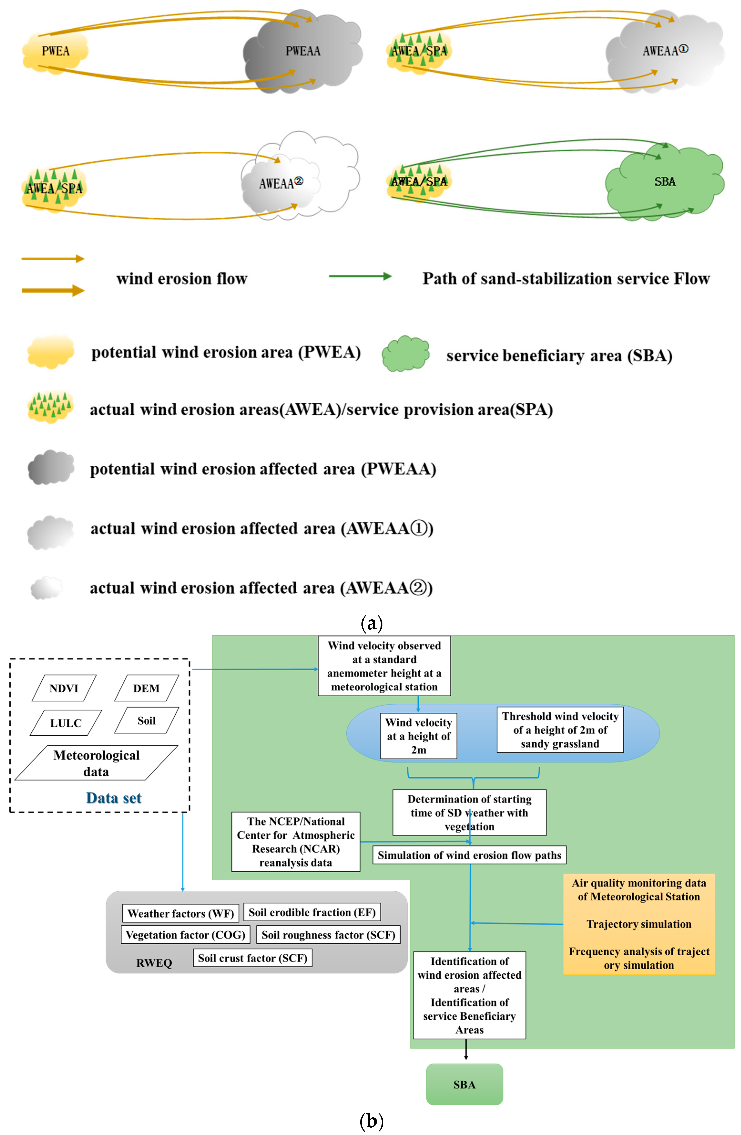
The spatial and temporal distribution of PM10 can accurately reflect the extent and degree of dust storms [13]. We screened the meteorological stations with PM10 monitoring value greater than 200 during the dust storm, and then analyzed the spatial-temporal distribution characteristics of PM10 at the dust storm before, during, and after, As shown in Figure 10. The R2 between PM10 and grid frequency is 0.8083 (Figure 11), which indicates that it is feasible to determine the SBA based on the HYSPLIT model.
Since the Longmenkou hydrological station, the Yellow River channel is the SBA of the soil conservation service of the LPES. However, due to the lack of sediment monitoring data from the Longmenkou hydrological station and Tongguan hydrological station, the scour-siltation volume of the Longmenkou-Tongguan and Tongguan-Xixiayuan sections cannot be counted. Therefore, we used the available sediment monitoring data of each river section to compare with the simulation results [44]. The results show a coefficient of determination (R2) of 0.6845 between them, which indicates that the simulation results of the radiation intensity of soil conservation service are relatively reliable.

3.3. Assessment of Ecological Compensation

The above research shows that the typical areas of NESZ provide essential ES. The cross-regional transmission of these ES brings great benefits to SBA. In terms of sharing the benefit ratio, SPA is the area that benefits more, but other SBAs have also benefited from the ES provided by SPA. In fact, SPA is mainly located in the underdeveloped areas in the west of China, and SBA is mainly located in the developed areas in the east, especially Beijing, Tianjin, and other places. From the perspective of coordinated regional development, SBA should pay reasonable ECF to SPA to relieve the financial pressure of SPA located in the west, which will promote the sustainable development of ecological construction, so that SPA can continue to provide ES with high efficiency. For this, there should be a more credible scheme for determining the ECF paid by SBA to SPA. So based on the principle of “more benefits, more compensation”, this paper proposed a different ECS (Figure 9J–L).
Similar to the benefits of sharing sand-stabilization service, the Ordos shares the most sand-stabilization service among all SBA, so it should bear the most ECF. That is, the Ordos should pay about 79 , 631.07 × 10 4 RMB, which accounts for about 36.28% of the total amount of ECF. The remaining ECF will be shared by 16 regions, except for Ordos according to their beneficial benefits. Among these 16 regions, IM paid the most, about 66 , 121.03 × 10 4 RMB. SX comes second, requiring 16 , 094.34 × 10 4 RMB. The ECF was payable by other SBAs decreased with distance. The Hb province (Suizhou) that paid the least ECF is only 7.5 × 10 4 RMB.
The lower reaches of LPES benefit from about 33.86 × 10 8 RMB, which should be paid as EC to LPES. The Longmen-Yuyuan section paid the most, about 11.62 × 10 8 RMB, accounting for 24.32% of the total amount. Followed by the Yuyuan-Xixiayuan section, which is about 7.24 × 10 8 RMB, accounting for 12.91%. The cost of ecological compensation decreases with the increase in distance, and the minimum payment for the Sunkou-Aishan section is about 0.42 × 10 8 RMB.
The total amount of payment to SPA in the beneficiary areas of the Songhua River Basin is 4.00 × 10 8 RMB. According to the SPA-SBA location, for the Lesser Khingan mountains, 5012.09 × 10 4 RMB should be paid by 57 hydrological response units benefiting from its ES. The 166 hydrological response units should pay 5012.09 × 10 4 RMB to the Greater Khingan Mountains. The Changbai Mountains should receive about 33,954.13 ×   10 4 RMB of EC from 49 hydrological response units.

4. Discussion

4.1. Policy Implications

The ESRAF can provide policymakers with clear and compelling evidence of the monetary value of the ES radiation effect. The results of the typical area show that it is feasible to use available data and methods to estimate ESRAF. ESRAF can give prominence to the values of nature and their contributions to human well-being, similar to the radiation effect of the city on the surrounding countryside. If the results of ES radiation assessment are included in government decision-making, it will contribute to the realization of important social goals (such as Sustainable Development Goals) (Figure 12). ESRAF can not only be used for an ecosystem service assessment but also provide a basis for determining the EC of SBA. At present, the evaluation of ES is often focused on locality but ignores the cross-regional flow characteristics of ES. ESRAF is a useful method for cross-regional assessment of ES. In particular, it is also a powerful tool for assessing the effectiveness of government ecological protection or ecological restoration and ecological construction. Moreover, it is very imperative to enable policymakers to understand the previously inaccurate range of SBA and the ambiguous ES radiation effects intuitively and clearly. This is of great significance for strengthening ecological construction and ecological restoration in critical areas in the future, that is, determining the best area through multi-scenario simulation to obtain the most ES radiation effects. At the same time, by providing scientific and reasonable ecological information, the government can save public investment and use the saved funds where it is more needed. In addition, ESRAF is an essential basis for determining the EC of SBA. Because in the past and current ECS, the schemes are either unable to reach a consensus because of the widely different expectations, determined based on game theory, or uniformly stipulated by the central government. Ecological information is often missing in these programs. Although some programs have become templates for promotion in China, there are still many problems. For example, in the Xin’anjiang model, the EC between Anhui Province and Zhejiang Province is based on the water quality monitoring results at the boundary of the two provinces [45]. If the water quality of the river section between the two provinces does not meet the evaluation standard (p ≤ 1), Anhui Province will pay RMB 100 million to Zhejiang Province due to the unqualified water quality management of the upper reaches of Xin’an River (RMB; in 2020, the average exchange rate between us dollar and RMB were 6.8974). Otherwise, Zhejiang Province will pay 100 million yuan to Anhui Province. This scheme provides an advanced model for river cross-regional ecological compensation in other regions of China, but there are still some issues that have not been resolved. For example, the fairness of this ECS needs to be considered. Although 100 million yuan is a drop in the bucket for the two provinces, the economic development of Anhui Province is different from that of Zhejiang Province. As we all know, compared with Zhejiang, Anhui is much behind. In a study in 2020, the per capita GDP of Anhui in 2019 was 58,496 yuan, which was only 54.4% of that of Zhejiang [46]. Even more remarkable though, how are the 100 million yuan ECF determined? Our research can solve this problem by simulating the radiation benefits generated by the ecosystem services flow. Perhaps the “simulation result” is more than 100 million, but stakeholders can negotiate according to our research results to achieve an ECF acceptable to both sides.
The ESRAF provides a basis for cross-regional economic compensation by measuring the value and location of the production and use of ecosystem services, and can also play an important role in reducing poverty. The areas involved in the NESZ are mostly located in central and western China. Many areas have rich ecosystem assets, but they are relatively poor in conventional economic indicators (per capita GDP). Provinces that benefit from the ES of NESZ tend to be far wealthier. Ecological compensation can maintain the ecosystem in SPA, which is also conducive to alleviating poverty and promoting sustainable economic development [47,48]. The results of studies in typical districts show that it is important to incorporate ESRAF into decision-making. For example, in the Ordos, the grassland grazing prohibitions bans have been implemented for many years, and the deterioration of the local ecological environment has been curbed and gradually evolving in the direction of improvement [49]. In addition, the local government has also invested heavily in implementing a series of ecological protection and ecological restoration projects, such as protecting virgin forests, turning vulnerable farmland into forests and grasslands, and stopping grazing to let grasslands recover, etc. However, no matter the grassland grazing prohibition order, or the ecological protection projects such as returning farmland to forest and natural forest protection, these measures have some conflicts with the current individual economic interests of local farmers and herdsmen. According to a study, according to one study, about 70% of farmers and herdsmen indicated that they may be grazing illegally during grazing prohibition or rest periods [50]. Therefore, it is necessary to pay ECF to SPA through cross-regional EC to compensate farmers and herdsmen for the opportunity cost lost due to grazing prohibition or rest grazing. Moreover, to some extent, it has restricted the development of the local economy, due to the policy leaning towards “ecological protection” [51,52,53]. ESRAF will provide decision-makers with clear information about the scope and benefits of ES, reduce the differences among stakeholders in the negotiation of compensation costs, form a positive interaction between SBA and SPA, and promote the harmonious development of economic development and ecological protection.
In addition, the ESRAF provides the possibility to evaluate the performance of policies, especially policies on ecological construction. The NESZ has a total area of 315,200 km2, accounting for about one-third of the total land area of China, involving 732 districts and counties, and is aimed at maintaining and improving the ecosystem services of the entire country [16]. Moreover, the government has invested a huge amount of money in ecological construction to improve its stability [54,55,56,57]. For these regions, ESRAF provides an effective tool for evaluating policy performance.

4.2. Limitations and Next Steps

The research of ESRAF is at an early stage of development, there is still a lot of work to be conducted, and it needs continuous exploration and improvement to be mature.
First, we need to recognize that ESRAF is at an early stage, which may lead to inaccurate estimation of ES due to the influence of data. Moreover, regarding the three ecosystem service radiation models constructed in this article, there are still many details that need to be perfected. However, at present, an important function of ESRAF is to provide a technical roadmap for ES radiation assessment and use cases to explore the areas affected by ecosystem services in cross-regional transmission and the benefits it brings to SBA. Moreover, with the advancement of remote sensing technology, there will be more and more remote sensing data with higher resolution (time and space) and more spectral information, and the limitations of the data will gradually decrease. Nevertheless, there are still some data used to assess other types of ecosystem services that cannot be obtained through remote sensing technology and need to be measured in the field.
Second, the radiation effect evaluation model based on ES flow is constructed, but the spatial transmission process of ES is complicated. We have to omit some details and only study the ES radiation effects from a macro perspective. For example, the process of sand emission, the state of movement of sediment in rivers with different flow rates. Especially in the study of the radiation effect of water conservation services, since the process of water conservation is extremely complex, and there are many disputes about the process of water conservation in academic circles, we adopted the statistical model to research. In the following research, we will consider the use of higher-resolution meteorological and LULC data and more advanced atmospheric transport models to simulate the dust dispersion process and use the modified unsteady flow formula to study the state of sediment movement at different speeds. Additionally, we will learn from related research results in hydrology, ecology, and other fields, upgrades to the water conservation services radiation assessment model make it gradually become a processed model. Moreover, we are still exploring how to verify the radiation range of the water conservation service. Nevertheless, the results of this study are still statistically significant.
Third, we have only evaluated the radiation effects of the main ES in typical areas, but have not evaluated all ecosystem services and their radiation effects. The reason is that all types of ES have not yet reached a consensus, and the understanding of the connotation of some ES is still insufficient. Furthermore, the lack of relevant data is an important reason why this work cannot be carried out more comprehensively. For example, how does the ecosystem affect the precipitation patterns of the local and surrounding areas? This ecological process is very complex and involves multiple disciplines. In the future, we need to understand the connotation and radiation transmission effect of this ES based on ecological process through interdisciplinary learning. In addition, there may be some ES that we are unable to characterize at present, and their radiation effects will become clear only after more understanding of the ecosystem and its contribution to human well-being.
Finally, in China, the underdeveloped central and western regions provide excellent ES for the economic construction of the eastern region. Therefore, the eastern region should pay for the ecological interests of the central and western regions through ecological compensation fees, and guide the redistribution of ecological interests between regions with economic benefits, so as to achieve sustainable economic and environmental development between regions. However, EC is a complex issue, not just an ecological issue, involving many fields, such as environmental science, economics, management, sociology, etc. According to the research framework proposed in this paper, the ecological compensation scheme may not be in line with the reality of society. However, it is unreasonable to ignore radiation effects at all. We believe that effectively identifying the spatial scope and benefit level of SBA is one of the important references for determining EC standards.

5. Conclusions

To prevent large-scale loss of natural capital, the Chinese government’s investment in ecological environment construction and improvement is increasing. The ES radiation effect can play an important role in evaluating the effectiveness of government ecological projects and determining the area and amount of EC. However, there is a lack of research on the ES radiation effect, and the existing research results that can provide a basis for decision-making ecological information are still very few. Therefore, there is an urgent need for new methods to obtain this information and provide this well-understood ecological information to policymakers. Just as the research on the economic radiation effects of urban agglomerations gives policymakers information on how cities can promote the development of surrounding villages, the research on the ES radiation effect can provide policymakers with useful information on how the ecosystem services generated by SPA benefit the surrounding area, the scope, and extent of the benefits. Based on the theory of ES flow, this paper constructs an ESRAF to study the spatial scope, amount, and benefit level benefiting from ES provided by the ecosystem in typical areas in the NESZ in 2015. About 16 provinces and cities have received the sand-stabilization service provided by the Ordos Ecosystem, which has avoided huge investments in dust removal for these areas. Soil conservation services trap a lot of soil in the Loess Plateau Ecological Screen, which reduces the sediment concentration of the Yellow River and downstream sediment deposition. The water conservation service beneficiary area is primarily located near the Northeast Forest Belt, with 266 hydrological response units, covering an area of 8.98 × 10 4 km2. and based on the above research results, a differentiated ECS was proposed. The ecological compensation fee paid by each beneficiary area is inversely proportional to the radiation effect, that is, the ecological compensation fee with the distance from SPA. The results of typical areas show that it is feasible to use the ESRAF constructed in this paper and the existing data to evaluate the radiation effects of sand-stabilization service, soil conservation service, and water conservation service. As data and methods improve, this research framework can be improved over time.

Author Contributions

Conceptualization, K.S.; methodology, K.S.; software, K.S.; validation, K.S.; formal analysis, K.S. and X.J.; investigation, K.S.; resources, K.S.; data curation, K.S.; writing—original draft preparation, K.S. and X.J.; writing—review and editing, K.S. and X.J.; visualization, K.S.; supervision, K.S.; project administration, K.S.; funding acquisition, K.S; All authors have read and agreed to the published version of the manuscript.

Funding

This research was funded by Youth Science Foundation of Natural Science Foundation of Guangxi grant number 2022GXNSFBA035570 and the National Key Research and Development Program of China grant number 2018YFC0507303.

Institutional Review Board Statement

Not applicable.

Data Availability Statement

Publicly available datasets were analyzed in this study. The data sources and access links are indicated in the text.

Acknowledgments

We thank Depeng Yue, Teng Niu and Ge Wang from Beijing Forestry University for their support to the author.

Conflicts of Interest

The authors declare no conflict of interest.

References

  1. Halpern, B.S.; Walbridge, S.; Selkoe, K.A.; Kappel, C.V.; Micheli, F.; d’Agrosa, C.; Bruno, J.F.; Casey, K.S.; Ebert, C.; Fox, H.E.; et al. A global map of human impact on marine ecosystem. Science 2008, 321, 948–952. [Google Scholar] [CrossRef] [PubMed] [Green Version]
  2. Islam, S.M.; Habib, A. How impact investing firms are responding to sustain and grow social economy enterprises in light of the COVID-19 pandemic. J. Bus. Ventur. Insights 2022, 18, e00347. [Google Scholar] [CrossRef]
  3. Ouyang, Z.; Song, C.; Zheng, H.; Polasky, S.; Xiao, Y.; Bateman, I.J.; Liu, J.; Ruckelshaus, M.; Shi, F.; Xiao, Y.; et al. Using gross ecosystem product (GEP) to value nature in decision making. Proc. Natl. Acad. Sci. USA 2020, 117, 14593–14601. [Google Scholar] [CrossRef] [PubMed]
  4. Lynch, A.H.; Wu, W. Impacts of Fire and Warming on Ecosystem Uptake in the Boreal Forest. J. Clim. 2000, 13, 2334–2338. [Google Scholar] [CrossRef]
  5. Costanza, R.; d’Arge, R.; De Groot, R.; Farber, S.; Grasso, M.; Hannon, B.; Limburg, K.; Naeem, S.; O’neill, R.V.; Paruelo, J.; et al. The value of the world’s ecosystem services and natural capital. Nature 1997, 387, 253–260. [Google Scholar] [CrossRef]
  6. Loomes, R.; O’Neill, K. Nature’s Services: Societal Dependence on Natural Ecosystems. Pac. Conserv. Biol. 1997, 6, 220–221. [Google Scholar] [CrossRef] [Green Version]
  7. Qiu, Z.; Feng, Z.; Song, Y.; Li, M.; Zhang, P. Carbon sequestration potential of forest vegetation in China from 2003 to 2050: Predicting forest vegetation growth based on climate and the environment. J. Clean. Prod. 2020, 252, 119715. [Google Scholar] [CrossRef]
  8. Viglizzo, E.F.; Paruelo, J.M.; Laterra, P.; Jobbágy, E.G. Ecosystem service evaluation to support land-use policy. Agric. Ecosyst. Environ. 2012, 154, 78–84. [Google Scholar] [CrossRef]
  9. Xie, G.; Xiao, Y.; Lu, C. Study on ecosystem services: Progress, limitation and basic paradigm. Chin. J. Plant Ecol. 2006, 30, 191–199. [Google Scholar]
  10. Chen, P.; Feng, Z.; Mannan, A.; Chen, S.; Ullah, T. Assessment of soil loss from land use/land cover change and disasters in the Longmen shan mountains, China. Appl. Ecol. Environ. Res. 2019, 17, 11233–11247. [Google Scholar] [CrossRef]
  11. Zhao, X.; Feng, Z.; Zhou, Y.; Lin, Y. Key Technologies of forest resource examination system development in China. Engineering 2020, 6, 491–494. [Google Scholar] [CrossRef]
  12. Ouyang, Z.; Zheng, H. Ecological mechanisms of ecosystem services. Acta Ecol. Sin. 2009, 29, 6183–6188. [Google Scholar]
  13. Su, K.; Sun, X.; Guo, H.; Long, Q.; Li, S.; Mao, X.; Niu, T.; Yu, Q.; Wang, Y.; Yue, D. The Establishment of a cross-regional differentiated ecological compensation scheme based on the benefit areas and benefit levels of sand-stabilization ecosystem service. J. Clean. Prod. 2020, 270, 122490. [Google Scholar] [CrossRef]
  14. Han, Y.W.; Tuo, X.S.; Gao, J.X.; Gao, X.T. Ecosystem services radiation of significant eco-function area in the lower reaches of Heihe River. Acta Ecol. Sin. 2010, 30, 191–199. [Google Scholar]
  15. Xie, Y.; Li, D.; Ma, X.; Zhang, S. Ecological radiation model research in human settlement ecological environment assessment:a case stustudy of Longgang District of Shenzhen City. China Environ. Sci. 2010, 30, 279–283. [Google Scholar]
  16. Feng, Y.; He, C.; Yang, Q.; He, J. Evaluation of ecological effect in land use planning using ecosystem service value method. Trans. Chin. Soc. Agric. Eng. 2014, 9, 201–211. [Google Scholar]
  17. Verhagen, W.; Kukkala, A.S.; Moilanen, A.; van Teeffelen, A.J.; Verburg, P.H. Use of demand for and spatial flow of prioritizing areas for ecosystem services. Conserv. Biol. 2016, 31, 860–871. [Google Scholar] [CrossRef] [Green Version]
  18. Casalegno, S.; Bennie, J.; Inger, R.; Gaston, K.J. Regional Scale Prioritisation for Key Ecosystem Services, Renewable Energy Production and Urban Development. PLoS ONE 2014, 9, e107822. [Google Scholar] [CrossRef] [PubMed] [Green Version]
  19. Xu, J.; Xiao, Y.; Xie, G.; Zhen, L.; Wang, Y.; Jiang, Y. The Spatio-Temporal Disparities of Areas Benefitting from the Wind Erosion Prevention Service. Int. J. Environ. Res. Public Health 2018, 15, 1510. [Google Scholar] [CrossRef] [Green Version]
  20. Wang, X.; Le, S.; Zhang, M. Ecosystem pattern change and its influencing factors of “two barriers and three belts”. Chin. J. Ecol. 2019, 38, 2138–2148. [Google Scholar]
  21. Ouyang, Z.Y.; Zheng, H.; Xie, G.D.; Yang, W.; Liu, G.; Shi, Y.; Yang, D. Accounting theories and technologies for ecological assets, ecological compensation and scientific and technological contribution to ecological civilization. Acta Ecol. Sin. 2016, 36, 5185–5193. [Google Scholar]
  22. Fisher, B.; Turner, R.K.; Morling, P. Defining and classifying ecosystem services for decision making. Ecol. Econ. 2009, 68, 643–653. [Google Scholar] [CrossRef] [Green Version]
  23. Potts, T.; Burdon, D.; Jackson, E.; Atkins, J.; Saunders, J.; Hastings, E.; Langmead, O. Do marine protected areas deliver flows of ecosystem services to support human welfare? Mar. Policy 2013, 44, 139–148. [Google Scholar] [CrossRef] [Green Version]
  24. Fryrear, D.W.; Bilbro, J.D.; Saleh, A.; Schomberg, H.; Stout, J.E.; Zobeck, T.M. RWEQ: Improved wind erosion technology. J. Soil Water Conserv. 2000, 55, 183–189. [Google Scholar]
  25. Chi, W.; Zhao, Y.; Kuang, W.; He, H. Impacts of anthropogenic land use/cover changes on soil wind erosion in China. Sci. Total Environ. 2019, 668, 204–215. [Google Scholar] [CrossRef]
  26. Li, D.; Xu, D.; Wang, Z.; You, X.; Zhang, X.; Song, A. The dynamics of sand-Stabilization services in Inner Mongolia, China from 1981 to 2010 and its relationship with climate change and human activities. Ecol. Indic. 2018, 88, 351–360. [Google Scholar] [CrossRef]
  27. Stein, A.F.; Draxler, R.R.; Rolph, G.D.; Stunder, B.J.B.; Cohen, M.D.; Ngan, F. NOAA’s HYSPLIT atmospheric transport and dispersion modeling system. Bull. Am. Meteorol. Soc. 2016, 96, 2059–2077. [Google Scholar] [CrossRef]
  28. Moroz, B.E.; Beck, H.L.; Bouville, A.; Simon, S.L. Predictions of dispersion and deposition of fallout from nuclear testing using the NOAA-HYSPLIT meteorological model. Health Phys. 2010, 99, 252–269. [Google Scholar] [CrossRef]
  29. Meester, T.D. Soil erosion and conservation. Earth-Sci. Rev. 1985, 24, 68–69. [Google Scholar] [CrossRef]
  30. Slack, R.B.; Welch, R. Soil Conservation Service Runoff Curve Number Estimates From Landsat Data. J. Am. Water Resour. Assoc. 2010, 16, 887–893. [Google Scholar] [CrossRef]
  31. Mirakhorlo, M.S.; Rahimzadegan, M. Evaluating estimated sediment delivery by Revised Universal Soil Loss Equation (RUSLE) and Sediment Delivery Distributed (SEDD) in the Talar Watershed, Iran. Front. Earth Sci. 2020, 14, 50–62. [Google Scholar] [CrossRef]
  32. Gokmen, T.; Vijay, P.S. Transport capacity models for unsteady and non-equilibrium sediment transport in alluvial channel. Comput. Electron. Agric. 2012, 86, 26–33. [Google Scholar]
  33. Itatani, K.; Okada, T.; Uejima, T.; Tanaka, T.; Ono, M.; Miyaji, K.; Takenaka, K. Intraventricular Flow Velocity Vector Visualization Based on the Continuity Equation and Measurements of Vorticity and Wall Shear Stress. Jpn. J. Appl. Phys. 2013, 52, 1044–1055. [Google Scholar] [CrossRef] [Green Version]
  34. Yamaguchi, S.; Izumi, N. The effects of non-equilibrium sediment transport process on instability of duneformation. Proc. Hydraul. Eng. 2010, 51, 1015–1020. [Google Scholar] [CrossRef] [Green Version]
  35. Gibbs, A.G.; Fukuzato, F.; Matzkin, L.M. Evolution of water conservation mechanisms in Drosophila. J. Exp. Biol. 2003, 206, 1183–1192. [Google Scholar] [CrossRef] [Green Version]
  36. Zeng, Z.; Piao, S.; Lin, X.; Yin, G.; Peng, S.; Ciais, P.; Myneni, R. Global evapotranspiration over the past three decades: Estimation based on the water balance equation combined with empirical models. Environ. Res. Lett. 2012, 7, 014026. [Google Scholar] [CrossRef]
  37. Zhang, K.; Kimball, J.S.; Nemani, R.R.; Running, S.W. A continuous satellite-derived global record of land surface evapotranspiration from 1983 to 2006. Water Resour. Res. 2010, 46, W09522. [Google Scholar] [CrossRef] [Green Version]
  38. Karim, W.M.; Hashim, M.G. Development of a New D16 Algorithm for Single Flow Direction Model; Springer International Publishing: Cham, Switzerland, 2014. [Google Scholar]
  39. Ord, J.K.; Getis, A. Local Spatial Autocorrelation Statistics: Distributional Issues and an Application. Geogr. Anal. 2010, 27, 286–306. [Google Scholar] [CrossRef]
  40. Yan, L.; Wang, Y.; Chu, H.; Tang, J. The climate influence of anthropogenic land-use changes on near-surface wind energy potential in China. Chin. Sci. Bull. 2008, 18, 2859–2866. [Google Scholar]
  41. Liu, R.; Thomas, B.; Shi, X.; Zhang, X.; Wang, Z.; Zhang, Y. Effects of ground cover management on improving water and soil conservation in tree crop systems: A meta-analysis. Catena 2021, 199, 105085. [Google Scholar] [CrossRef]
  42. Yin, L.; Wang, X.; Zhang, K.; Xiao, F.; Cheng, C.; Zhang, X. Trade-offs and synergy between ecosystem services in National Barrier Zone. Geogr. Res. 2019, 38, 2162–2172. [Google Scholar]
  43. Sun, B.F.; Zhao, H.; Lu, F.; Wang, X.K. Spatial and temporal patterns of carbon sequestration in the Northeastern Forest Regions and its impact factors analysis. Acta Ecol. Sin. 2018, 38, 4975–4983. [Google Scholar]
  44. Ministry of Water Resources the China. Zhongguo Heliu Nisha Gongbao 2015; China Water & Power Press: Beijing, China, 2016. [Google Scholar]
  45. Jiang, K.; Merrill, R.; You, D.; Pan, P.; Li, Z. Optimal control for transboundary pollution under ecological compensation: A stochastic differential game approach. J. Clean. Prod. 2019, 241, 118391. [Google Scholar] [CrossRef]
  46. Fan, H. Annual Report on Social Development of Anhui (2020); Social Sciences Academic Press: Beijing, China, 2021. [Google Scholar]
  47. Anderson, B.P. Review: Green Growth That Works: Natural Capital Policy and Finance Mechanisms around the World. Electron. Green J. 2020, 177–179. [Google Scholar] [CrossRef]
  48. Ashendorff, A.; Principe, M.A.; Seeley, A.; LaDuca, J.; Beckhardt, L.; Faber, W.; Mantus, J. Watershed protection for New York City’s supply. J. Am. Water Work. Assoc. 1997, 89, 75–88. [Google Scholar] [CrossRef]
  49. Li, W.; Wang, C.; Wang, H.; Chen, J.; Yuan, C.; Li, T.; Wang, W.; Shen, H.; Huang, Y.; Wang, R.; et al. Distribution of atmospheric particulate matter (PM) in rural field, rural village and urban areas of northern China. Environ. Pollut. 2014, 185, 134–140. [Google Scholar] [CrossRef]
  50. Hu, Y.F.; Liu, J.Y.; Qi, Y.Q.; Shi, H.D. Positivist analysis on the effects of ecological projects in the farming-pastoral transition belt of Inner Mongolia Autonomous Region. Geogr. Res. 2010, 29, 1452–1460. [Google Scholar]
  51. Liu, M.; Dries, L.; Heijman, W.; Huang, J.; Zhu, X.; Hu, Y.; Chen, H. The Impact of Ecological Construction Programs on Grassland Conservation in Inner Mongolia, China. Land Degrad. Dev. 2018, 29, 326–336. [Google Scholar] [CrossRef] [Green Version]
  52. Chang, R.; Tang, H. Sensitivity analysis on methods of estimating carbon sequestration in grassland ecosystem of Inner Mongolia, China. J. Plant Ecol. 2008, 32, 810–814. [Google Scholar]
  53. Mannan, A.; Feng, Z.; Ahmad, A.; Liu, J.; Saeed, S.; Mukete, B. Carbon dynamic shifts with land use change in Margallah hills national park, Islamabad (Pakistan) from 1990 to 2017. Appl. Ecol. Environ. Res. 2018, 16, 3197–3214. [Google Scholar] [CrossRef]
  54. Yang, W.; Li, L. Efficiency evaluation of industrial waste gas control in China: A study based on data envelopment analysis (DEA) model. J. Clean. Prod. 2018, 179, 1–11. [Google Scholar] [CrossRef]
  55. Lu, J.; Feng, Z.; Zhu, Y. Estimation of forest biomass and carbon storage in China based on forest resources inventory data. Forests 2019, 10, 650. [Google Scholar] [CrossRef] [Green Version]
  56. Zhu, Y.; Feng, Z.; Lu, J.; Liu, J. Estimation of forest biomass in Beijing (China) using multisource remote sensing and forest inventory data. Forests 2020, 11, 163. [Google Scholar] [CrossRef]
  57. Hu, J. Firmly March on the Path of Socialism with Chinese Characteristics and Strive to Complete the Building of a Moderately Prosperous Society in All Respects. Renmin Press 2012, 4, 4–59. [Google Scholar]
Figure 1. Connotation of ecosystem service radiation effect.
Forests 14 00246 g001
Figure 2. Distribution of the study area in the national ecological sheltering zone.
Forests 14 00246 g002
Figure 3. Research framework of ECR effect.
Forests 14 00246 g003
Figure 4. Schematic diagram of provision-transmission-benefit of sand-stabilization ecosystem service. (a) is the radiation transmission diagram of sand control facilities. And (b) is the flow chart for identifying the SBA of sand stabilization service.
Forests 14 00246 g004
Figure 5. Schematic diagram of provision-transmission-benefit of soil conservation service. The schematic diagram of the radiative transmission of soil conservation service is shown in (a). And (b) is a flow-process diagram for identifying the SBA of soil conservation service.
Forests 14 00246 g005aForests 14 00246 g005b
Figure 6. Schematic diagram of provision-transmission-benefit of water conservation service. The schematic diagram of the radiative transmission of the water conservation service is shown in (a). (b) is a flow-process diagram for identifying the SBA of a water conservation service.
Forests 14 00246 g006
Figure 7. Comparison of soil erosion modulus obtained by 137Cs observations and in this study.
Forests 14 00246 g007
Figure 8. Comparison of the survey results of the Ministry of Water Resources and USLE model estimated results.
Forests 14 00246 g008
Figure 9. Spatial distribution (AC), radiative transmission process (DF), location of SBA (GI), and cross-regional ECS (JL) of the SPA in the typical area of NESZ.
Forests 14 00246 g009
Figure 10. Spatiotemporal distribution of PM10 during dust activity (a) and PM10 greater than 200 (b).
Forests 14 00246 g010
Figure 11. PM10 and grid frequency.
Forests 14 00246 g011
Figure 12. The relationship between ecosystems, radiation effects, and decision-making. Evaluating the radiation effects of ecosystem services can be used to evaluate the effectiveness of ecological construction and play a role in the evaluation of government policies and performance. On the other hand, government decision-making in turn affects the state of the ecosystem, especially through measures such as ecological restoration and ecological protection. The figures are modified according to Ouyang et al. (2020) [3].
Forests 14 00246 g012
Table 1. List of data.
NameResolutionSource
Sediment data-Ministry of Water Resources People’s Republic of China
Soil Data-National Soil Information Service Platform of China
gridded population and GDP1 kmResource and Environmental Science Data Center of Chinese Academy of Sciences
DEM30 mResource and Environmental Science Data Center of Chinese Academy of Sciences
land use data250 mNASA
meteorological-Cold and Arid Regions Sciences Data Center
social-economic data-annual statistical yearbooks
Reanalysis of meteorological data-NCAR
Air quality data-China National Environmental Monitoring Centre
administrative division-Resource and Environmental Science Data Center of Chinese Academy of Sciences
Table 2. Input data of RWEQ model.
VariableUnit
Monthly precipitationmm
Monthly precipitation daysd
Monthly global solar radiationMJ
Monthly average temperature°C
Soil particle size composition%
The average daily wind speedm/s
Monthly vegetation coverage%
Altitudem
Table 3. The surface runoff coefficient of different land-use types.
Land Use Type α Land Use Type α Land Use Type α
Evergreen broad-leaved forest2.67Sparse forest19.2Grassy marshland8.2
Evergreen coniferous forest3.02Evergreen broad-leaved shrub4.26Grassland4.78
Broad-leaved mixed forest2.29Broad-leaved
Deciduous shrub
4.17Grass9.37
Broad-leaved deciduous forest1.33Evergreen coniferous shrub4.17
Broad-leaved coniferous forest0.88Sparse shrub19.2
Table 4. Comparison of several research results on WCS in the NFB.
20052010
Su kai 799.95 × 10 8   m 3 or 365 mm a 1153.44 × 10 8   m 3 or 386.17 mm a
Sun binfeng et al. [42] 610 × 10 8   m 3 610 × 10 8   m 3
Yin lichang et al. [43]358.36 mm a376.47 mm a
Disclaimer/Publisher’s Note: The statements, opinions and data contained in all publications are solely those of the individual author(s) and contributor(s) and not of MDPI and/or the editor(s). MDPI and/or the editor(s) disclaim responsibility for any injury to people or property resulting from any ideas, methods, instructions or products referred to in the content.

