Article

Maintaining Carbon Storage Does Not Reduce Fish Production from Mangrove-Fish Pond System: A Case Study in Coastal Area of Subang District, West Java, Indonesia

by
Elham Sumarga
1,*,
Tati Suryati Syamsudin
1,
Sheila Pertiwi Rahman
2,
Azzahra Ramadhanti Kurnia Putri
2,
Velia
2,
Alfiazka Anargha Aldi
2 and
Mohammad Basyuni
3,4
1
School of Life Sciences and Technology, Istitut Tekonologi Bandung, Jalan Ganesa 10, Bandung 40132, Indonesia
2
Forestry Engineering Study Program, School of Life Sciences and Technology, Institut Teknologi Bandung, Sumedang 45363, Indonesia
3
Department of Forestry, Faculty of Forestry, Universitas Sumatera Utara, Medan 20155, Indonesia
4
Center of Excellence for Mangrove, Universitas Sumatera Utara, Medan 20155, Indonesia
*
Author to whom correspondence should be addressed.
Forests 2022, 13(8), 1308; https://doi.org/10.3390/f13081308
Submission received: 30 June 2022 / Revised: 8 August 2022 / Accepted: 11 August 2022 / Published: 16 August 2022
(This article belongs to the Special Issue Biomass Estimation and Carbon Stocks in Forest Ecosystems)

Abstract

:
Deforestation and degradation of mangrove forests can be categorized as key environmental problems in Indonesia. These problems are majorly driven by overexploitation and the conversion of mangroves into brackish water aquaculture areas. One of the most common aquaculture systems traditionally developed in the coastal areas is the mangrove-fish pond system that combines fish production with existing trees. This study aims to analyze the environmental and economic aspects of mangrove-fish pond aquaculture in different levels of mangrove cover in the coastal area of Subang District, West Java, Indonesia. The spatial analysis method was used to analyze mangrove distribution and identify the current coverage in the aquaculture area. The economic aspect was analyzed, based on the costs and revenue from fish production, while the environmental aspect was represented by carbon storage, which is among the crucial mangrove ecosystem services. This study estimated carbon storage in the four-carbon pools: above- and below-ground biomass, deadwood, and litterfall. Based on the combination of visual interpretation of Sentinel 2A satellite images and field observations, approximately 667 ha of mangrove-fish pond was identified. This study found that there were no significant differences in fish production and net income from mangrove-fish pond aquaculture at various levels of mangrove cover. Meanwhile, the ponds with high mangrove cover stored higher carbon than those with medium and low mangrove covers. This indicates that maintaining carbon storage does not reduce fish production from mangrove-fish pond aquaculture.

1. Introduction

Many Indonesian coastal areas face complex environmental problems [1,2,3], which include the widespread occurrences of beach abrasion, seawater intrusion, soil subsidence, and flooding [4,5,6,7]. The current trend of sea-level rise [8] also worsens the situation [9]. Meanwhile, the coastal environmental problems are highly related to deforestation and degradation of mangrove forests [10,11], which are the natural shields of coastal areas.
Deforestation and degradation of mangrove forests can be categorized as key environmental problems in Indonesia. A previous report recorded that the highest rate of mangrove deforestation occurred in three decades before 2010, where about 40% of mangrove cover was lost [12]. Between 2009 and 2019, the loss reached approximately 182 thousand ha [13], which occurred in many regions, including coastal areas on Java Island [14,15]. The main driving factors included over-exploitation of mangrove forests and conversion of the mangrove forests into brackish water aquaculture areas [10,16].
One of the most common aquaculture systems that are traditionally developed in coastal areas on Java Island is the mangrove-fish pond system, which combines fish production with the existing trees. Since there is no fixed rule on the proportion of the area of mangrove and fish ponds, people develop the system in different levels of mangrove cover. People also assume that high fish production is in line with increase in the pond area, which, consequently, reduces the area for mangrove trees.
Different studies have explored and encouraged the implementation of a mangrove-fish pond with a dominant proportion of mangrove trees (more than 50%), which is recognized as a sylvofishery system. Basyuni et al. [17,18] developed silvofishery based on the density of mangrove seedlings and saplings at Lubuk Kertang, North Sumatra, Indonesia to support milkfish production. Takashashi and Tan [19] also explored the relationship between the stand structure of secondary mangroves and flooded duration by brackish water to introduce and design a silvofishery system around Lam River, Vietnam. However, the general adoption of the silvofishery system by local people in Indonesia still faces significant challenges [20]. Therefore, there is a need to further investigate the economic and environmental advantages of silvofishery to enhance mangrove preservation and the livelihood of improvement.
Currently, there are still limited studies on the direct comparison of fish production and other ecosystem services from the mangrove-fish pond system with different levels of mangrove cover. Basyuni et al. [21] investigated this issue, but the comparison only focused on the financial aspect. All compared aquaculture practices were also limited to silvofishery systems, with mangrove cover of 75%, 84%, and 90%. Therefore, further investigation is required, particularly in the form of expanding the comparison, by considering both economic and environmental, aspects, and assessing aquaculture practices with contrasting levels of mangrove cover.
This study was carried out to address the above issue in the coastal area of Subang District, West Java, Indonesia. A spatial analysis method was used to analyze mangrove distribution and identify the current coverage of mangrove in the aquaculture area, which is categorized into low, medium, and high. This was followed by the analysis of the economic and environmental aspects of aquaculture in all classes of mangrove cover. The economic aspects involved quantification of fish production and valuation of net revenue from the production. Meanwhile, the environmental aspect was represented by carbon storage, which is among the most crucial mangrove ecosystem services. Mangrove forests significantly contribute to global climate regulation, and can store higher carbon compared to most other forest types [22,23]. Enhancing carbon sequestration and storage of mangrove forest is also currently one of the main priorities of the Indonesian government in its aim to achieve a carbon neutral target.
The coastal area of Subang District was selected as the study area due to its extensive practices of mangrove-fish pond aquaculture, which is traditionally managed by local people. The determination of the relationship between mangrove cover and fish production helps local people improve their aquaculture practices, particularly in selecting the best proportion of mangrove cover. People commonly assume that reducing mangrove cover will potentially increase fish production. Therefore, this study examines the acceptance of this assumption. This study also provides important inputs for other stakeholders of coastal management, particularly local governments in formulating a better method of integrating mangrove preservation and local peoples’ improvement in livelihood, which can also be implemented in other regions with similar problems.

2. Materials and Methods
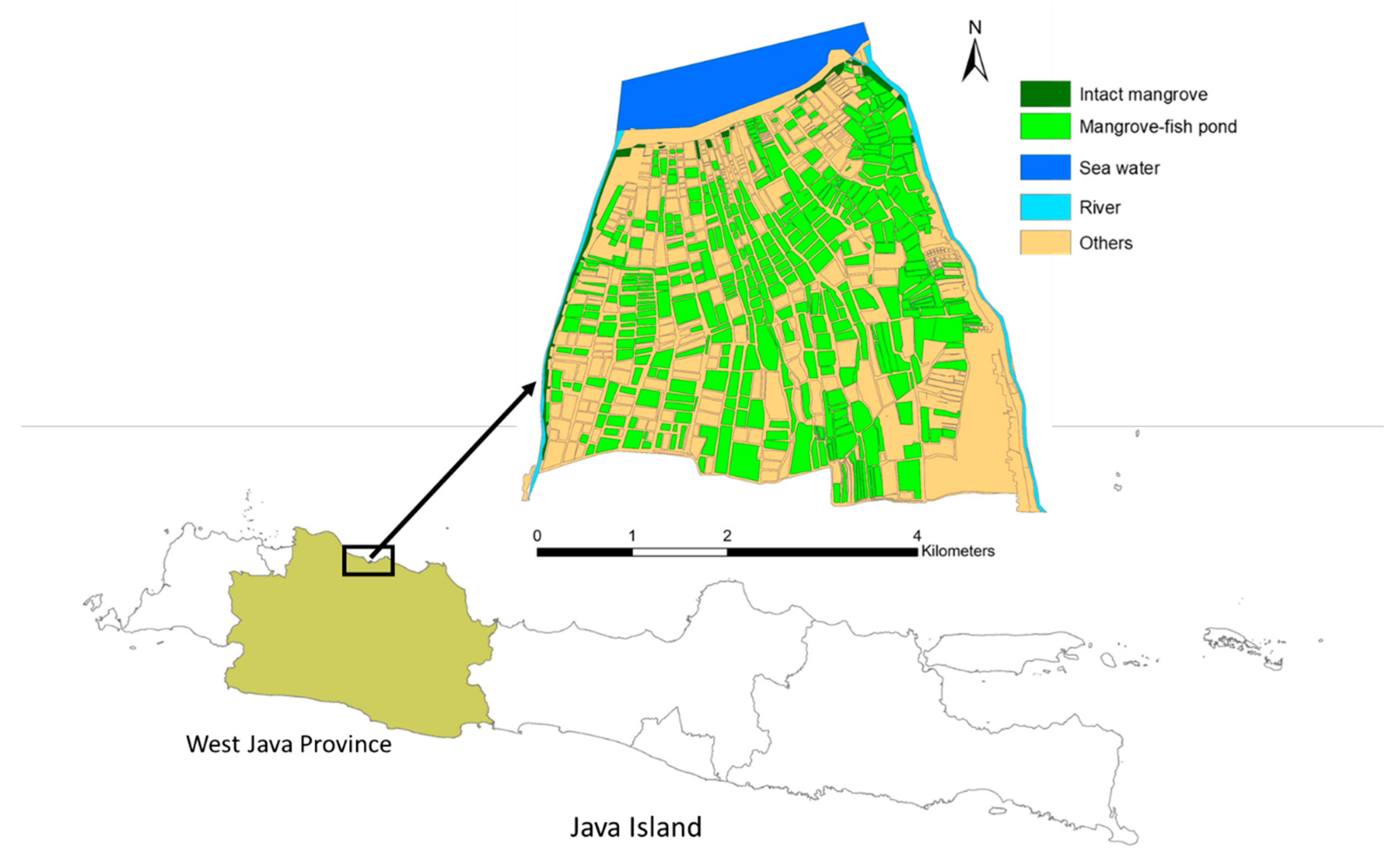
2.1. Study Area

This study was carried out in the coastal area between Blanakan and Ciasem Rivers in Subang District, West Java province, Indonesia. Figure 1 shows the geographical information of the study area that covers approximately 1848 ha, and which is dominated by aquaculture areas. Several small patches of intact mangroves exist, distributed particularly in the estuary and riverine areas.

2.2. Data Collection and Analysis

This study spatially analyzed the distribution of mangroves to identify the variation of the cover in the aquaculture area with a mangrove-fish pond system. This spatial information was used as the basis for the comparison of fish production and carbon storage in three categories, namely low, medium, and high. The procedures of data collection and analysis are described below.

2.2.1. Spatial Analysis of Mangrove Cover

The distribution of mangrove cover in the aquaculture areas was analyzed in two steps. These included the discrimination of the fish pond areas from other land uses and the rough classification of the mangrove cover into three classes, namely low (around <33%), medium (around 33–67%), and high (around >67%). This was based on a visual interpretation of Sentinel 2-A Satellite image 2020, with a spatial resolution of 10 m. Subsequently, an on-screen digitizing method and field observation were combined for the classification. The accuracy of this classification was measured by validation using 100 independent ground truth data. In the second step, the percentage of mangrove cover classes was quantified, based on the Normalized Difference Vegetation Index (NDVI) value extracted from the Sentinel 2-A satellite image 2020. A threshold of 0.32 was used to determine the existence of mangrove [24]. A pixel with an NDVI value of more than 0.32 was considered as covered by mangroves, and vice versa.

2.2.2. Carbon Storage Analysis

This study estimated the carbon storage of the mangrove in four carbon pools, which included above- and below-ground biomass, deadwood, and litterfall. The description of sampling technique, data collection, and analysis for carbon storage estimation in each pool are described below.

Above-Ground Biomass

Stratified sampling was used to estimate the above-ground carbon of the mangrove. The stratification was based on the low, medium, and high classes in mangrove-fish pond areas. The area with intact mangrove were also sampled for comparison. The plots were proportionally distributed in the three classes of mangrove cover. The plot was a square of 10 m for the aquaculture area with a high cover of mangrove (52 plots), 20 m with a medium cover of mangrove (15 plots), 50 m with a low cover of mangrove (9 plots), and 10 m for intact mangrove (10 plots). The primary data collected in each sample plot were the tree diameter at breast height (DBH) for all mangrove stands. The DBH was measured at 1.3 m height from ground level, or above stilt root. These data were used to estimate the above-ground biomass using an allometric equation.
This study used two allometric equations (Table 1) to estimate the above-ground biomass of mangrove trees. This was because only two mangrove tree species were discovered in the study area, namely Avicennia marina and Rhizophora mucronata. A ratio of 0.47 was used for the conversion of above-ground biomass into carbon [25].

Below-Ground Biomass

Below-ground carbon represents the carbon stored in roots, which was also estimated with the tree DBH. This was carried out using the allometric equations listed in Table 2. A ratio of 0.47 was also used for the conversion of below-ground biomass into carbon.

Carbon on Deadwood

Carbon on deadwood was estimated for standing and fallen dead trees using the procedures of above-ground carbon estimation. Meanwhile, some correction factors were used to convert the above-ground carbon of the living tree to that of deadwood. Correction factors of 0.9, 0.8, and 0.7 were used for dead trees with branches and twigs, and main branches, and those without branches and twigs, respectively.

Carbon on Litterfall

Carbon on litterfall was estimated based on the wet and dry weight data of litterfall. Samples of litterfall were collected from mangrove-fish pond areas with three classes of cover using two square plots of 30 cm for each class. The wet weight of mangrove litterfall was measured directly in the field. Meanwhile, the dry weight was measured after drying the litter under 70 °C conditions for four days and was converted into carbon with a conversion factor of 0.47 [25].

2.2.3. Costs and Revenue Analysis of Fish Production

The economic aspect of mangrove-fish pond aquaculture was measured based on interviews with 27 local farmers, the selection of which ensured equal representation of those managing ponds with high, medium, and low mangrove covers. The interview explored information on the size of mangrove-fish pond managed by the respondent, type of fish or shrimp cultivated, costs for production, including the purchase of juvenile fish, pond preparation, feed, etc., as well as frequency of harvest per year, the quantity of fish production, and gross income. The information was finally used to measure the annual net income from fish production (per ha) in mangrove-fish ponds in the three classes of cover. Analysis of variance was used to determine whether there is a significant difference in net income from fish production in different mangrove covers.

3. Results and Discussion
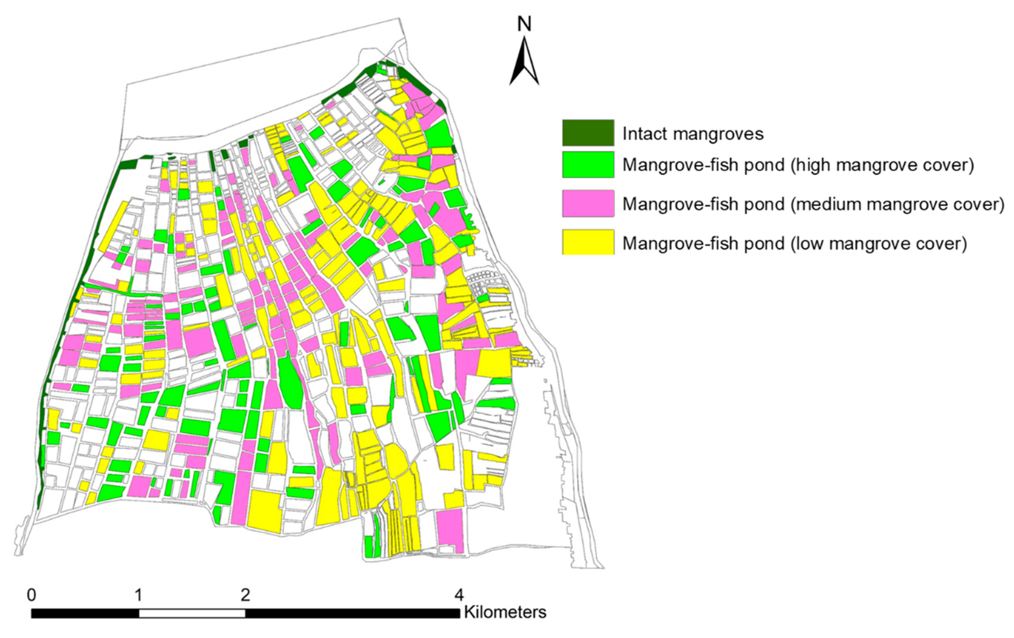
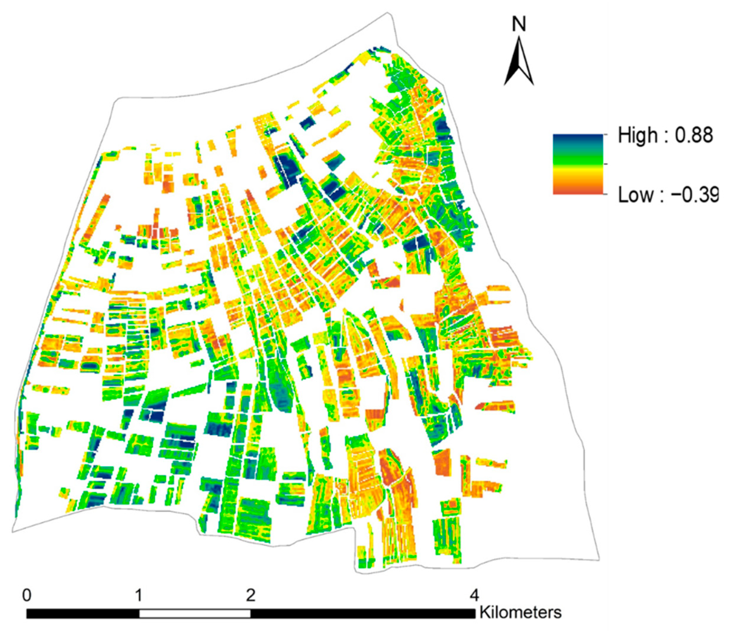
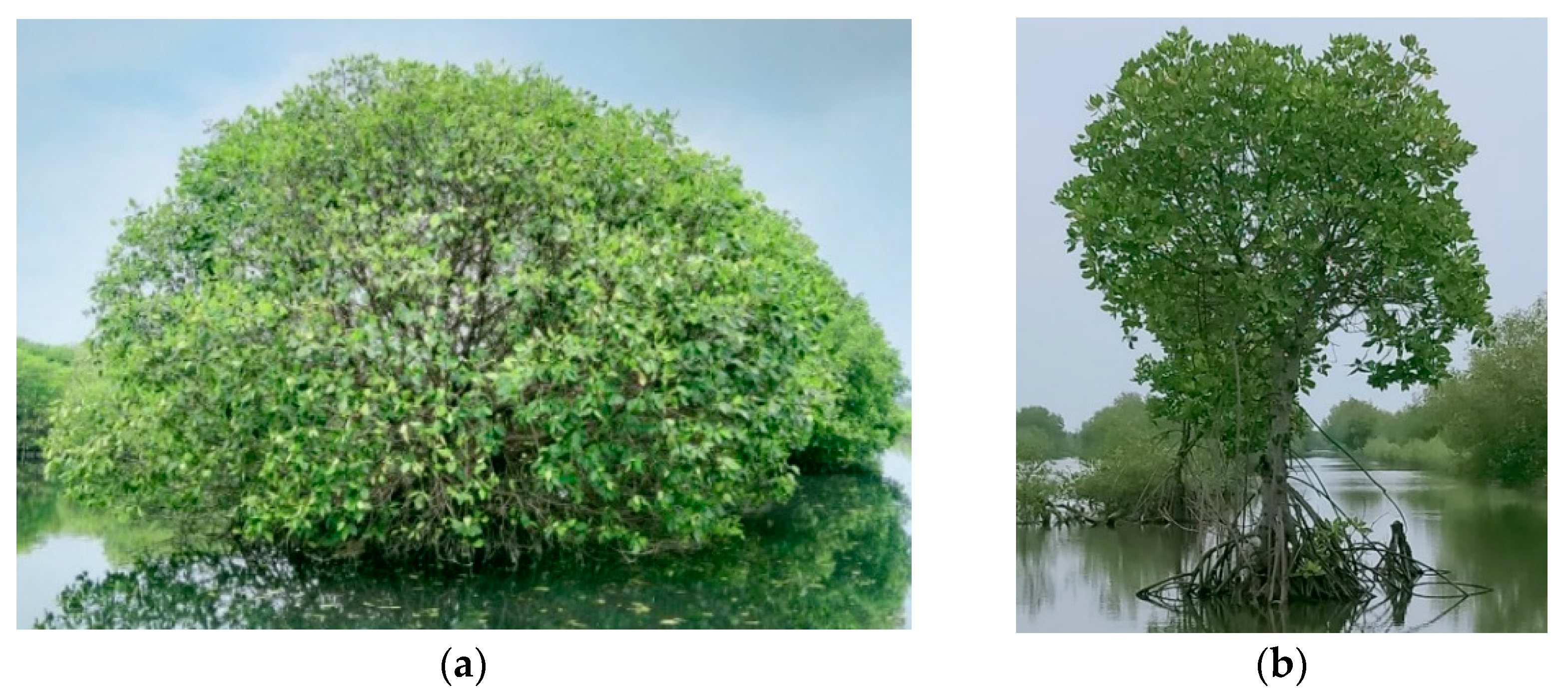
3.1. Mangrove Cover

Based on the combination of field survey and visual interpretation of Sentinel 2A 2020 satellite images, 667 ha areas of mangrove-fish pond aquaculture and 20 ha of intact mangrove were identified in the study area. The mangrove-fish pond areas were further divided into three classes: high, medium, and low. The results showed that the mangrove-fish pond areas were dominated by low mangrove cover (308 ha), followed by medium (191 ha), and, finally, high mangrove cover (168 ha). Figure 2 shows the distribution of the three classes of mangrove-fish pond areas. A validation using 100 independent ground truth data showed a high overall accuracy of the mapping (92%).
Further analysis of the NDVI extracted from Sentinel 2A satellite images showed the quantitative information of mangrove covers in the pond areas. The distribution of the NDVI is shown in Figure 3, with values ranging from −0.39 to 0.88. A threshold of 0.32 was used to determine the existence of mangroves. Based on the NDVI map, the percentages of 50%, 31%, and 19% were obtained for mangrove-fish pond areas with high, medium, and low covers.
Figure 4 shows the profile diagram of the three classes of mangrove cover derived from field observation. A plot of 5200 m2 was used for the mangrove-fish pond with high mangrove cover, 6000 m2 for the one with medium cover, 22,500 m2 for the one with low cover, and 500 m2 for intact mangroves.

3.2. Carbon Storage

The two species of mangrove tree discovered in the study area were Avicennia marina and Rizhophora mucronata (Figure 5). The results showed that the Avicennia marina was more abundant, particularly regarding the seedling and sapling growth stages. A total of 1550 individuals of Avicennia marina were recorded in the sample plots (347 square plots of 10 m), which consisted of 149 trees, 859 saplings, and 542 seedlings. Furthermore, 321 individuals of Rhizophora mucronata were recorded, consisting of 176 trees, 94 saplings, and 51 seedlings.
Based on the DBH data, the above- and below-ground carbon stored in mangrove vegetation was calculated using the allometric equations listed in Table 1 and Table 2. Meanwhile, Table 3 shows the estimate of above and below carbon storage in three classes of cover in mangrove-fish pond areas and intact mangroves. The estimate of carbon storage in dead wood, which was discovered only in the mangrove-fish pond with medium cover (1 stand), and in the litter, is also listed in Table 3.
Table 3 shows that carbon storage in the mangrove-fish pond with high cover was about five times higher than that of medium cover, and almost 15 times greater than low mangrove cover. This indicated that the common farmers’ preference to increase the proportion of fish pond significantly reduced the amount of carbon stored in the mangrove-fish pond areas. However, compared to carbon storage in intact mangroves, those in high cover systems were still much lower by more than three times. This showed an unavoidable implication that there was conversion of intact mangroves into mangrove-fish pond aquaculture.

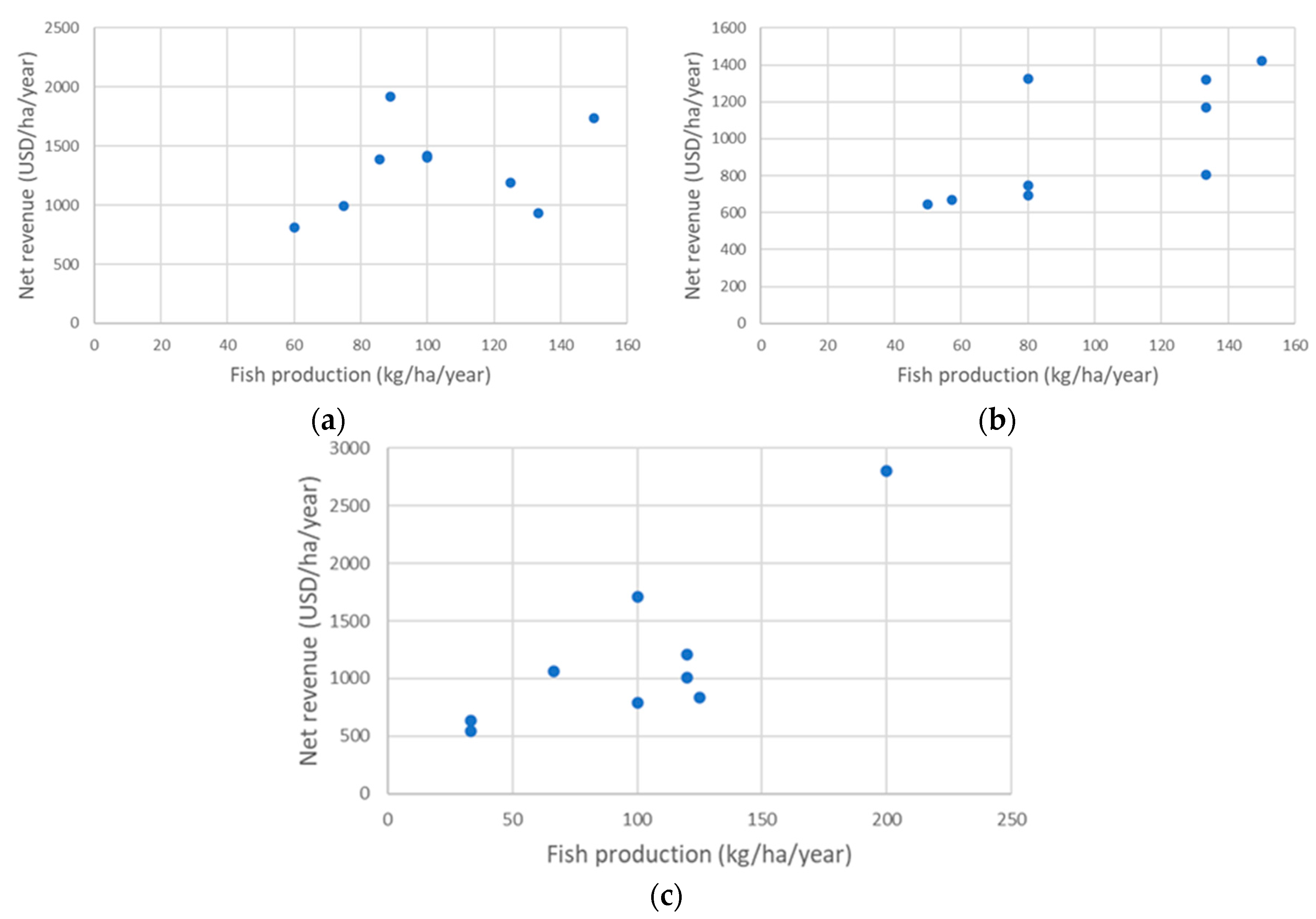
3.3. Fish Production

The results showed that farmers traditionally managed mangrove-fish pond aquaculture, with an average of 3.5 ha area per individual. Farmers commonly cultivated milkfish, tilapia fish, Asian tiger prawn, and vaname shrimp, with two harvests per year. The production costs mainly included the cost of purchasing juvenile fish and pond preparation. There were no costs for fish feed, since farmers relied fully on the natural food provided by the mangrove-fish pond ecosystem. Furthermore, the average fish production and net revenue from mangrove-fish pond aquaculture with different classes of mangrove cover are listed in Table 4. The scatter plots showing the relationship between fish production and net revenue in each class of mangrove cover are presented in Figure 6.
The analysis of variance showed that there was no significant difference between fish production and net revenue from mangrove-fish pond aquacultures in the three classes of cover. These results were not in line with the common assumption that high fish production is proportional to an increase in the fish pond area, which reduces the area for mangrove trees. Figure 6 shows the variation of the relationship pattern between fish production and net revenue in three classes of mangrove cover. Increase of fish production was commonly followed by increase of net revenue, with different levels of deviation in the three classes of mangrove cover. The highest deviation occurred in mangrove-fish ponds with high mangrove cover. This was indicated by the low correlation coefficient (0.3), that was lower than the correlation coefficient of medium mangrove cover (0.69) and low mangrove cover (0.8). Based on interviews with local farmers, the deviation was mostly due to the variation of production costs. Spending less on production costs, and even potentially providing less fish production, did not always generate lower net revenue.

3.4. Implication for Mangrove-Fish Pond Development

This study shows the capability of a mangrove-fish pond system with high cover to maintain greater carbon storage without reducing fish production. It was also discovered that silvofishery is the best option for mangrove-fish pond aquaculture development. This is because silvofishery is a win-win solution, meeting the growing demand for fishery cultivation by local people and the need for preservation of mangroves to maintain their critical ecosystem services, such as carbon sequestration and biodiversity habitat.
The results support the substantial points raised by previous studies, where economic and environmental advantages were discovered in silvofishery practices. Rahman and Mahmud [30] reported that aquacultures with a silvofishery system were economically feasible. Meanwhile, Hastuti and Budihastuti [31] stated that mangrove seedlings in a silvofishery system significantly improved environmental quality, which supported optimal conditions for fish growth. According to Musa et al. [32], the silvofishery system effectively improved the quality of water supply, as well as that of wastewater, and increased the diversity of the phytoplankton community.
It was also discovered that the silvofishery system has low capital requirements and is recognized as an organic farming practice. This is because farmers do not allocate any costs for fish feed or use chemicals for production. The presence of R. mucronata in the middle or edge of the pond is ideal as a natural predator repellent and a source of food for fish growth from the breakdown of leaves, twigs, and fruit litter, which causes the formation of detritus. Basyuni et al. [17,18,21] also suggested the silvofishery system with mangroves species, such as R. mucronata, R. apiculata, and R. stylosa, due to their significant role in increasing the growth phytoplankton.
Based on the results, further development of the silvofishery system in Indonesian coastal areas is recommended, particularly in regions with a high demand for land for fish cultivation. Development of silvofishery should be integrated into the national program on mangrove restoration, with the main focus on restoring degraded mangroves and abandoned coastal fish ponds. The development of silvofishery should also target the existing mangrove-fish pond areas by improving the mangrove cover by at least 50%. The high capacity of the silvofishery system in storing carbon, reported on in this study, confirms the potential contribution of silvofishery development to the achievement of Indonesia’s carbon neutral target. For the forestry sector, the Indonesian government is targeting the achievement of a carbon net sink by 2030, in which the rate of carbon sequestration is expected to be equal to, or even higher than, carbon emissions. This policy is known as Indonesia’s FoLU (Forest and other Land Uses) Net Sink 2030 [33].
The expansion of the ecosystem services approach to support silvofishery development was also suggested. Previous studies have shown the capacity of the ecosystem services approach in support of sustainable management of natural resources and the environment [34,35,36,37]. The use of this approach requires the following: further exploration of multiple ecosystem services from the silvofishery system, showing the economic value of the ecosystem services, and a trade-off analysis of the ecosystem service values from different types of mangrove-fish pond systems. This would strengthen the understanding of the broader economic values of the silvofishery system, compared to other mangrove-fish pond practices, and would promote the system and encourage its implementation by local farmers. Moreover, convincing local farmers to adopt silvofishery needs to be accompanied by other efforts, such as financial and technical support from the government, the development of a pilot program, and an incentive mechanism for payment of ecosystem services provided by the system.

4. Conclusions

This study examined the relationship between mangrove cover in fish pond aquaculture and two parameters, representing economic as well as environmental aspects, namely fish production, and carbon storage. This study identified approximately 667 ha of mangrove-fish ponds in the study area, which were classified into three groups of mangrove cover, namely high (168 ha), medium (191 ha), and low (308 ha). The carbon stored was 33.5 tons C/ha for aquaculture areas with high cover, 6.8 tons C/ha for areas with medium cover, and 2.4 tons C/ha for areas with low cover. The average net revenue from fish production from mangrove-fish pond aquaculture with high, medium, and low mangrove covers were USD 1310/ha/year, USD 966/ha/year, and USD 1172/ha/year, respectively. The analysis of variance showed that there was no significant difference of net revenue in different classes in the mangrove covers. These results were not in line with the common assumption that high fish production is proportional to increase in fish pond area, thereby reducing the area for mangrove trees. It was also discovered that silvofishery is the best option for mangrove-fish pond aquaculture, and its further development, as the main part of coastal ecosystem management, is recommended. These results provide important input for continuous efforts in integrating mangrove preservation and improvement in local peoples’ livelihoods.

Author Contributions

Conceptualization, E.S. and T.S.S.; methodology, E.S., T.S.S., S.P.R., A.R.K.P., V. and A.A.A.; software, E.S., S.P.R., A.R.K.P., V. and A.A.A.; validation, S.P.R., A.R.K.P., V. and A.A.A.; formal analysis, E.S., T.S.S., S.P.R., A.R.K.P., V. and A.A.A.; investigation, E.S., S.P.R., A.R.K.P., V. and A.A.A.; resources, E.S., T.S.S., S.P.R., A.R.K.P., V. and A.A.A.; data curation, E.S., S.P.R., A.R.K.P., V. and A.A.A.; writing—original draft preparation, E.S.; writing—review and editing, E.S., T.S.S. and M.B.; visualization, E.S., S.P.R., A.R.K.P., V. and A.A.A.; supervision, E.S. and T.S.S.; project administration, E.S.; funding acquisition, E.S. and T.S.S. All authors have read and agreed to the published version of the manuscript.

Funding

This research was funded by the Institute for Research and Community Services Institut Teknologi Bandung through the excellent research program (Program Riset Unggulan ITB) 2021.

Institutional Review Board Statement

Not applicable.

Informed Consent Statement

Not applicable.

Data Availability Statement

The data presented in this study are available on request from the corresponding author.

Acknowledgments

We thank Perum Perhutani RPH Tegal Tangkil, KPH Purwakarta for providing technical support during field observation.

Conflicts of Interest

The authors declare no conflict of interest. The funders had no role in the design of the study; in the collection, analyses, or interpretation of data; in the writing of the manuscript, or in the decision to publish the results.

References

  1. Sejati, A.W.; Buchori, I.; Kurniawati, S.; Brana, Y.C.; Fariha, T.I. Quantifying the impact of industrialization on blue carbon storage in the coastal area of Metropolitan Semarang, Indonesia. Appl. Geogr. 2020, 124, 102319. [Google Scholar] [CrossRef]
  2. Handayani, W.; Chigbu, U.E.; Rudiarto, I.; Putri, I.H.S. Urbanization and Increasing Flood Risk in the Northern Coast of Central Java—Indonesia: An Assessment towards Better Land Use Policy and Flood Management. Land 2020, 9, 343. [Google Scholar] [CrossRef]
  3. Adyasari, D.; Pratama, M.A.; Teguh, N.A.; Sabdaningsih, A.; Kusumaningtyas, M.A.; Dimova, N. Anthropogenic impact on Indonesian coastal water and ecosystems: Current status and future opportunities. Mar. Pollut. Bull. 2021, 171, 112689. [Google Scholar] [CrossRef] [PubMed]
  4. Buchori, I.; Pramitasari, A.; Sugiri, A.; Maryono, M.; Basuki, Y.; Sejati, W. Adaptation to coastal flooding and inundation: Mitigations and migration pattern in Semarang City, Indonesia. Ocean. Coast. Manag. 2018, 163, 445–455. [Google Scholar] [CrossRef]
  5. Yastika, P.E.; Shimizu, N.; Abidin, H.Z. Monitoring of long-term land subsidence from 2003 to 2017 in coastal area of Semarang, Indonesia by SBAS DInSAR analyses using Envisat-ASAR, ALOS-PALSAR, and Sentinel-1A SAR data. Adv. Space Res. 2019, 63, 1719–1736. [Google Scholar] [CrossRef]
  6. Hamid, N.; Setyowati, D.L.; Juhadi, J.; Priyanto, A.S.; Suswanti, S.; Royyani, M.A.; Aroyandini, E.N. Sustainable Development of the Coastal Environment through Participatory Mapping of Abrasion-Prone Areas. J. Environ. Manag. Tour. 2021, 12, 1997–2009. [Google Scholar]
  7. Putra, D.B.E.; Hadian, M.S.D.; Alam, B.Y.C.S.; Yuskar, Y.; Yaacob, W.Z.W.; Datta, B.; Harnum, W.P.D. Geochemistry of groundwater and saltwater intrusion in a coastal region of an island in Malacca Strait, Indonesia. Environ. Eng. Res. 2021, 26, 200006. [Google Scholar] [CrossRef]
  8. Nurlatifah, A.; Martono; Susanti, I.; Suhermat, M. Variability and trend of sea level in southern waters of Java, Indonesia. J. South. Hemisph. Earth Syst. Sci. 2021, 71, 272–283. [Google Scholar] [CrossRef]
  9. Irawan, A.M.; Marfai, M.A.; Nugraheni, I.R.; Gustono, S.T.; Rejeki, H.A.; Widodo, A.; Mahmudiah, R.R.; Faridatunnisa, M. Comparison between averaged and localised subsidence measurements for coastal floods projection in 2050 Semarang, Indonesia. Urban Clim. 2021, 35, 100760. [Google Scholar] [CrossRef]
  10. Ilman, M.; Dargusch, P.; Dart, P.J.; Onrizal, O. A historical analysis of the drivers of loss and degradation of Indonesia’s mangroves. Land Use Policy 2016, 54, 448–459. [Google Scholar] [CrossRef]
  11. Eddy, S.; Milantara, N.; Sasmito, S.D.; Kajita, T.; Basyuni, M. Anthropogenic Drivers of Mangrove Loss and Associated Carbon Emissions in South Sumatra, Indonesia. Forests 2021, 12, 187. [Google Scholar] [CrossRef]
  12. FAO. The World’s Mangroves 1980–2005; Food and Agriculture Organization of the United Nations: Rome, Italy, 2007. [Google Scholar]
  13. Arifanti, V.B.; Novita, N.; Sabarno; Tosiani, A. Mangrove deforestation and CO2 emissions in Indonesia. IOP Conf. Ser. Earth Environ. Sci. 2021, 874, 012006. [Google Scholar] [CrossRef]
  14. Rudianto, R.; Bengen, D.G.; Kurniawan, F. Causes and Effects of Mangrove Ecosystem Damage on Carbon Stocks and Absorption in East Java, Indonesia. Sustainability 2020, 12, 10319. [Google Scholar] [CrossRef]
  15. Prayudha, B.; Siregar, V.; Ulumuddin, Y.I.; Suyadi; Prasetyo, L.B.; Agus, S.B.; Suyarso; Anggraini, K. The application of Landsat imageries and mangrove vegetation index for monitoring mangrove community in Segara Anakan Lagoon, Cilacap, Central Java. IOP Conf. Ser. Earth Environ. Sci. 2021, 944, 012039. [Google Scholar] [CrossRef]
  16. Nugraha, R.B.A.; Syaharani, L.; Iska, R.; Mulyana, D.; Wahyudin, Y.; Purbani, D.; Jayawiguna, H.; Triyono; Setiawan, A.; Fajar, P. The impact of land used changes on mangrove forest and shoreline dynamic in Muara Gembong, Bekasi, West Java. IOP Conf. Ser. Earth Environ. Sci. 2019, 241, 012018. [Google Scholar] [CrossRef]
  17. Basyuni, M.; Nasution, K.S.; Slamet, B.; Sulistiyono, N.; Bimantara, Y.; Putri, L.A.P.; Yusraini, E.; Lesmana, I. Introducing of a silvofishery pond on sapling and seedling density based in Lubuk Kertang Village, North Sumatera. IOP Conf. Ser. Earth Environ. Sci. 2019, 260, 012115. [Google Scholar] [CrossRef]
  18. Basyuni, M.; Nasution, K.S.; Bimantara, Y.; Hayati, R.; Slamet, B.; Sulistiyono, N. Mangrove vegetation supports milkfish production in silvofishery pond. IOP Conf. Ser. Earth Environ. Sci. 2019, 305, 012038. [Google Scholar] [CrossRef]
  19. Takashashi, K.; Tran, T.T. Study on Stand Structure of Secondary Mangrove Forest: Sonneratia caseolaris-Aegiceras corniculatum Stand for Introducing Silvofishery Systems to Shrimp Culture Ponds. In Global Changes and Sustainable Development in Asian Emerging Market Economies; Nguyen, A.T., Hens, L., Eds.; Springer: Berlin/Heidelberg, Germany, 2022; Volume 2. [Google Scholar] [CrossRef]
  20. Susilo, H.; Takahshi, Y.; Sato, G.; Nomura, H. The adoption of silvofishery system to restore mangrove ecosystems and its impact on farmers’ income in Mahakam Delta, Indonesia. J. Fac. Agric. Kyushu Univ. 2018, 63, 433–442. [Google Scholar] [CrossRef]
  21. Basyuni, M.; Yani, P.; Hartini, K.S. Evaluation of mangrove management through community-based silvofishery in North Sumatra, Indonesia. IOP Conf. Ser. Earth Environ. Sci. 2018, 122, 012109. [Google Scholar] [CrossRef]
  22. Murdiyarso, D.; Donato, D.; Kauffman, J.B.; Kurnianto, S.; Stidham, M.; Kanninen, M. Carbon Storage in Mangrove and Peatland Ecosystems: A Preliminary Account from Plots in Indonesia; Center for International Forestry Research: Bogor Regency, Indonesia, 2009. [Google Scholar]
  23. Donato, D.C.; Kauffman, J.B.; Murdiyarso, D.; Kurnianto, S.; Stidham, M.; Kaninen, M. Mangroves among the most carbon-rich forests in the tropics. Nat. Geosci. 2011, 4, 293–297. [Google Scholar] [CrossRef]
  24. Kusmana, C. Mangrove Response to Pollution; Bogor Agricultural University: Bogor, Indonesia, 2010. [Google Scholar]
  25. Aalde, H.; Gonzalez, P.; Gytarsky, M.; Krug, T.; Kurz, W.A.; Ogle, S.; Raison, J.; Schoene, D.; Ravindranath, N.H.; Elhassan, N.G.; et al. Chapter 4: Forest land. 2006 IPCC Guidelines for National Greenhouse Gas Inventories. Available online: https://www.ipcc-nggip.iges.or.jp/public/2006gl/pdf/4_Volume4/V4_04_Ch4_Forest_Land.pdf (accessed on 30 August 2021).
  26. Dharmawan, I.W.S.; Siregar, C.A. Soil carbon and estimation of vegetation carbon of Avicennia marina (Forsk.) Vierh. in Ciasem Purwakarta. J. For. Res. Nat. Conserv. 2008, 5, 317–328. [Google Scholar]
  27. Dharmawan, I.W.S. Estimation of above ground biomass of Rhizophora mucronata in Ciasem, Purwakarta. J. Indones. Agric. Sci. 2010, 15, 50–56. [Google Scholar]
  28. Komiyama, A.; Ong, J.E.; Poungparn, S. Allometry, biomass, and productivity of mangrove forests: A review. Aquat. Bot. 2008, 89, 128–137. [Google Scholar] [CrossRef]
  29. Komiyama, A.; Poungparn, S.; Kato, S. Common allometric equations for estimating the tree weight of mangroves. J. Trop. Ecol. 2005, 21, 471–477. [Google Scholar] [CrossRef]
  30. Rahman, M.M.; Mahmud, M.A. Economic feasibility of mangrove restoration in the Southeastern Coast of Bangladesh. Ocean. Coast. Manag. 2018, 161, 211–221. [Google Scholar] [CrossRef]
  31. Hastuti, D.H.; Budihastuti, R. Potential of mangrove seedlings for utilization in the maintenance of environmental quality within silvofishery ponds. Biotropia 2016, 23, 58–63. [Google Scholar]
  32. Musa, M.; Lusiana, E.D.; Buwona, N.R.; Arsad, S.; Mahmudi, M. The effectiveness of silvofishery system in water treatment in intensive whiteleg shrimp (Litopenaeus vannamei) ponds, Probolinggo District, East Java, Indonesia. Biodiversitas J. Biol. Divers. 2020, 21, 4695–4701. [Google Scholar] [CrossRef]
  33. Indonesian Ministry of Environment and Forestry. Operational Plan Indonesia’s Folu Net Sink 2030. 2022. Available online: https://www.menlhk.go.id/site/single_post/4705/operational-plan-indonesia-s-folu-net-sink-2030 (accessed on 8 August 2022).
  34. Sumarga, E.; Hein, L.; Edens, B.; Suwarno, A. Mapping monetary values of ecosystem services in support of developing ecosystem accounts. Ecosyst. Serv. 2015, 12, 71–83. [Google Scholar] [CrossRef]
  35. Assuma, V.; Bottero, M.; Caprioli, C.; Datola, G.; Mondini, G. Evaluation of Ecosystem Services in Mining Basins: An Application in the Piedmont Region (Italy). Sustainability 2022, 14, 872. [Google Scholar] [CrossRef]
  36. Pascual, A.; Giardina, C.P.; Povak, N.A.; Hessburg, P.F.; Asner, G.P. Integrating ecosystem services modeling and efficiencies in decision-support models conceptualization for watershed management. Ecol. Model. 2022, 466, 109879. [Google Scholar] [CrossRef]
  37. Sun, X.; Yang, P.; Tao, Y.; Bian, H. Improving ecosystem services supply provides insights for sustainable landscape planning: A case study in Beijing, China. Sci. Total Environ. 2022, 802, 149849. [Google Scholar] [CrossRef]
Figure 1. Study area.
Forests 13 01308 g001
Figure 2. Map of mangrove-fish pond aquaculture in different classes of mangrove covers.
Forests 13 01308 g002
Figure 3. Map of NDVI in the mangrove-fish pond areas.
Forests 13 01308 g003
Figure 4. Profile diagram of mangrove cover in (a) mangrove-fish pond with high mangrove cover (b) mangrove-fish pond with medium mangrove cover (c) mangrove-fish pond with low mangrove cover and (d) intact mangroves.
Forests 13 01308 g004
Figure 5. Mangrove tree species in the study area (a) Avicennia marina and (b) Rizhophora mucronata.
Forests 13 01308 g005
Figure 6. Scatter plot of the relationship between fish production and net revenue from mangrove-fish pond with (a) high mangrove cover (b) medium mangrove cover and (c) low mangrove cover.
Forests 13 01308 g006
Table 1. Allometric equations for above-ground biomass estimation.
Mangrove SpeciesAllometric EquationsSources
Avicennia marinaAGB = 0.1848 × D2.3524Dharmawan dan Siregar [26]
Rhizophora mucronataAGB = 0.1466 × D2.3136Darmawan [27]
AGB: Above-ground biomass (kg), D: tree DBH (cm).
Table 2. Allometric equations for below-ground biomass estimation.
Mangrove SpeciesAllometric EquationsSources
Avicennia marinaBGB = 1.28 × D1.17Komiyama et al. [28]
Rhizophora mucronataBGB = 0.1994 × ρ0.899 × D2.15Komiyama et al. [29]
BGB: Below-ground biomass (kg), D: tree DBH (cm).
Table 3. Carbon storage in four carbon pools in the study area.
Carbon PoolsMangrove-Fishpond with High Mangrove Cover (ton C/ha)Mangrove-Fishpond with Medium Mangrove Cover (ton C/ha)Mangrove-Fishpond with Low Mangrove Cover (ton C/ha)Intact Mangrove (ton C/ha)
Above ground biomass17.323.821.2267.61
Below ground biomass12.411.380.2342.68
Dead wood 0.04
Litter3.781.580.922.5
Total33.516.782.37112.78
Table 4. Fish production and net revenue from mangrove-fish pond aquaculture in the study area.
Types of Mangrove-Fish Pond AquacultureFish Production (kg/ha/year)Net Revenue (USD/ha/year)
Mangrove-fish pond with high mangrove cover1021310
Mangrove-fish pond with medium mangrove cover100966
Mangrove-fish pond with low mangrove cover1001172
Publisher’s Note: MDPI stays neutral with regard to jurisdictional claims in published maps and institutional affiliations.

