Article

Rapid Recent Deforestation Incursion in a Vulnerable Indigenous Land in the Brazilian Amazon and Fire-Driven Emissions of Fine Particulate Aerosol Pollutants

by
Gabriel de Oliveira
1,*,†,
Jing M. Chen
1,
Guilherme A. V. Mataveli
2,†,
Michel E. D. Chaves
3,†,
Hugo T. Seixas
4,
Francielle da S. Cardozo
2,
Yosio E. Shimabukuro
3,
Liming He
5,
Scott C. Stark
6 and
Carlos A. C. dos Santos
7
1
Department of Geography and Planning, University of Toronto, Toronto, ON M5S 3G3, Canada
2
Department of Geosciences, Federal University of São João del-Rei, São João del-Rei, MG 36307-352, Brazil
3
Remote Sensing Division, Brazilian National Institute for Space Research (INPE), São José dos Campos, SP 12227-010, Brazil
4
Satellite Monitoring Facility, Brazilian Agricultural Research Corporation, Campinas, SP 13070-115, Brazil
5
Canada Centre for Mapping and Earth Observation, Natural Resources Canada, Ottawa, ON K1S 5K2, Canada
6
Department of Forestry, Michigan State University, East Lansing, MI 48824, USA
7
Academic Unit of Atmospheric Sciences, Federal University of Campina Grande, Campina Grande, PB 58109-970, Brazil
*
Author to whom correspondence should be addressed.
These authors contributed equally to the work.
Forests 2020, 11(8), 829; https://doi.org/10.3390/f11080829
Submission received: 8 June 2020 / Revised: 20 July 2020 / Accepted: 28 July 2020 / Published: 30 July 2020

Abstract

:
Deforestation in the Brazilian Amazon is related to the use of fire to remove natural vegetation and install crop cultures or pastures. In this study, we evaluated the relation between deforestation, land-use and land-cover (LULC) drivers and fire emissions in the Apyterewa Indigenous Land, Eastern Brazilian Amazon. In addition to the official Brazilian deforestation data, we used a geographic object-based image analysis (GEOBIA) approach to perform the LULC mapping in the Apyterewa Indigenous Land, and the Brazilian biomass burning emission model with fire radiative power (3BEM_FRP) to estimate emitted particulate matter with a diameter less than 2.5 µm (PM2.5), a primary human health risk. The GEOBIA approach showed a remarkable advancement of deforestation, agreeing with the official deforestation data, and, consequently, the conversion of primary forests to agriculture within the Apyterewa Indigenous Land in the past three years (200 km2), which is clearly associated with an increase in the PM2.5 emissions from fire. Between 2004 and 2016 the annual average emission of PM2.5 was estimated to be 3594 ton year−1, while the most recent interval of 2017–2019 had an average of 6258 ton year−1. This represented an increase of 58% in the annual average of PM2.5 associated with fires for the study period, contributing to respiratory health risks and the air quality crisis in Brazil in late 2019. These results expose an ongoing critical situation of intensifying forest degradation and potential forest collapse, including those due to a savannization forest-climate feedback, within “protected areas” in the Brazilian Amazon. To reverse this scenario, the implementation of sustainable agricultural practices and development of conservation policies to promote forest regrowth in degraded preserves are essential.

1. Introduction

Intact forest ecosystems offer exceptional ecosystem service value through climate change mitigation, watershed regulation and biodiversity conservation. They are also crucial for human health and the future survival of indigenous communities [1,2]. Conversely, forest loss through clearing and biomass burning both contributes to greenhouse gas emissions and reduces evapotranspiration, exacerbating climate warming. It also induces direct human health threats through the production of dangerous fine particulate matter in the air [3,4]. The Amazon region has the largest rainforest in the world; however, the anthropic pressure and associated land-use and land-cover (LULC) changes have led to large-scale forest losses [5,6]. The consequences of Amazon deforestation are profound, though they are yet to be fully understood. Amazon deforestation causes decreases in biodiversity [7], alteration of rainfall regionally and perhaps globally [8,9], reduction in forest resilience to climate change related drought and other disturbances [10], alteration of regional climate [11], impacts on LULC dynamics [12], changes in water storage and hydrological dynamics [13] and enhancement of drought risks and impacts [14].
The primary drivers to deforestation in the Brazilian Amazon include supplying the cattle, crop and timber global markets, and local demands for food crops. Road expansion networks (both official and unofficial) are also related to deforestation in the Brazilian Amazon. Critically, these deforestation drivers are associated with controlled and uncontrolled fires [5,15]. In the state of Pará, where deforestation rates are among the highest in Brazil, Jusys [15] describes cattle ranching as the strongest driver of deforestation. To reduce forest loss and degradation in the Amazon the delimitation of protected areas and effective public forest management policies are essential [2,16,17,18].
Amazon deforestation rates fell overall between 1988 and 2012, which was the result of improvements in governance, monitoring and legal structure [19]. Optimistic scenarios at the beginning of the 2010s even envisioned the potential to the end of deforestation in the Brazilian Amazon by 2020 [20]. However, in recent years (mostly 2018 and 2019), annual deforestation rates have increased markedly, particularly in protected areas such as indigenous lands [21]. This new deforestation boom in the Brazilian Amazon is being driven by the political turmoil and economic recession in Brazil [22,23], which has favored deforestation and the expansion of agricultural activities in these areas, leading to increased tensions over indigenous land rights, and endangering native peoples and other protected groups and traditional lifestyles in the Amazon [23].
The effectiveness of conserving protected areas is primarily a function of government enforcement [2], which can endanger conservation efforts when agreements and regulations are subverted and bypassed for political reasons [24]. The work of Herrera et al. [25] examined the impacts of protected areas created by the federal government and state agencies in the Brazilian Amazon, considering internal impacts (within boundary) and spillovers (nearby). In the “Arc of Deforestation”, the internal benefits estimated for federal protected areas and indigenous lands are higher than for state-created protected areas. Within the “Arc of Deforestation” spillover benefits outside of the boundaries of protected areas were small or insignificant. In the case of the state of Pará; however, both federal protected areas and indigenous lands offer internal and spillover land protection benefits. These authors suggest that political and economic factors, in addition to enforcement agency objectives and capacities, are crucial for conservation strategies.
Typically, the deforestation and agricultural conversion processes employ fire for final clearing and land preparation [26]. For example, van der Werf et al. [27] found that 75% of fire emissions in Southern Amazon were associated with deforestation. Therefore, climate and human health sensitive trace gases (e.g., CO and CO2) and aerosol emissions from fires are also expected to increase with deforestation. Although several species of traces gases and aerosols are associated with fires, the particulate matter with a diameter less than 2.5 µm (PM2.5) is often chosen in studies related to fire emissions [28,29] due to its human health risk and for being considered a good tracer for the other aerosols and trace gases emitted from fires [4]. Amazon agricultural conversion and fire increases since 2018, along with increasing droughts and heatwaves under climate change [30], the interaction of wildfire and land conversion [31], which threatens long-term conversion of wet forest into savanna like states (‘savannization”) [32], are threatening to convert the Amazon from a net carbon sink to a net carbon source exacerbating climate warming [33].
The Apyterewa Indigenous Land, located in the state of Pará, Brazil, presented the second largest deforestation rates observed in indigenous lands in the Brazilian Amazon in 2019, according to the Brazilian National Institute for Space Research (INPE). To assess the impact of this deforestation in the Apyterewa Indigenous Land, we have conducted a case study aimed at understanding the drivers of the LULC changes after 2016. We have also quantified and evaluated the expected increase in PM2.5 emitted from fires resulting from deforestation related processes. The PM2.5 estimates were obtained from 2004 to 2019, which captures the transition from the strong governance period from the turn of the century to the mid-2010s to the new era of exploitative frontier expansion in the Brazilian Amazon and the current period.

2. Materials and Methods

2.1. Study Area

The location of the Apyterewa Indigenous Land is shown in Figure 1. This indigenous land was legally demarcated in 2007 in the municipality of São Félix do Xingu (state of Pará) with an area of approximately 7734 km2 [34]. There are currently 470 inhabitants of the Parakanã indigenous group living in Apyterewa [34].
As São Félix do Xingu is the second Amazonian municipality with more deforestation since 2008 (more than 3800 km2) [21], this indigenous land is severely endangered. Pasture expansion is the main deforestation driver in this region [35]. After a period of decreasing deforestation beginning in 2004 (139 km2) and reaching practically a rate of zero in 2012 (0.77 km2), annual deforestation rates started increasing significantly again in Apyterewa during the last two years (19.82 km2 and 85.25 km2 in 2018 and 2019, respectively) [21] and are expected to increase even more in 2020 [36].

2.2. Official Deforestation Data

We used the Brazilian official deforestation data from INPE for analyzing the historical deforestation patterns in the Apyterewa Indigenous Land. These data were used to monitor deforestation increases and LULC conversion in the Brazilian Amazon and were developed to drive inspections operations and enforcement to curb illegal deforestation. There are two distinct projects within INPE’s deforestation monitoring system: (i) the Brazilian Amazon Deforestation Satellite Monitoring Project (PRODES), which monitors clear-cut deforestation and provides annual accurate official deforestation rates of the Brazilian Amazon forest since 1988 [21], and (ii) the Near-Real Time Deforestation Detection System (DETER), which provides, since 2015, deforestation alerts to warn authorities about deforestation in Brazilian biomes [21]. In this work we used PRODES data from 2004 to 2019 and DETER data from 2016 to 2020. It should also be mentioned that the PRODES calendar does not consider the civil year; for example, the 2019 deforestation considers the period from 1 August 2018 to 31 July 2019.

2.3. Land Use and Land Cover Mapping

In order to evaluate the LULC changes in the study area, we used two images from the operational land imager (OLI) sensor on board the Landsat-8 satellite (path 225/row 064) obtained within a three-year interval (11 August 2016 and 26 July 2019) [37]. These images contain geometric corrections derived from control points of the Global Land Survey (GLS) database and terrain elevation data from the Shuttle Radar Topography Mission (SRTM). We chose the images based on the availability of clear-sky data and also acquired close to the same date to reduce variations in brightness due to changes in solar elevation and azimuth angles, as well as to avoid misinterpretations resulting from phenological changes in vegetation.
We adopted the geographic object-based image analysis (GEOBIA) approach to perform LULC mapping in the Apyterewa Indigenous Land. This approach, which presents better results than pixel-based alternatives, expands the analysis over the pixel reflectance information, segmenting features, dividing the images in geo-objects selected by shape, compactness and texture, collecting samples and performing classifications using geo-objects as a basic unit of analysis [38]. GEOBIA minimizes the within-class spectral variability by assigning all pixels in the object to an identical LULC class, better using the spatial information implicit within remotely sensed images such as size, shape and texture of objects, as well as facilitating the integration of contextual and semantic relationships among geographic objects [39].
The methodological procedure for obtaining LULC information involved five steps: (i) calculation of spectral indices to highlight LULC classes; (ii) segmentation of the OLI images into geo-objects using the multiresolution segmentation (MRS) algorithm, which groups pixels of each object according to 6 parameters assigned to each band: smoothness, color, weight, scale factor, shape and compactness [40]; (iii) collection of representative samples of each LULC classes of interest; (iv) geo-object classification by the support vector machine (SVM) algorithm [41] and (v) post-processing, which relied on visually evaluating if there were irregular or non-classified geo-objects in the resulting classification.
Spectral indices were utilized to increase the spectral separability of the different LULC classes and to improve segmentation. We used the normalized difference vegetation index (NDVI) [42], the soil-adjusted vegetation index (SAVI) [43] and the normalized difference water index (NDWI) [44], since these indices are sensitive to variations in vegetation, soil background and water bodies, respectively. Combining GEOBIA and vegetation indices allowed to better discriminate similar spatiotemporal phenomena than using only pixel’s reflectance and spectral bands [45].
Segmentation parameters values, defined based on OLI images characteristics and tests applied to the study area, were defined as follows: 50 for scale factor, 0.9 for shape and 0.8 for compactness. These parameters are related to the minimum segment size and the level of spectral separation between objects [46].
The sample dataset used to train the SVM algorithm was produced collecting 140 geo-objects for each image following a stratified random sampling method. LULC classes were defined in this step, based on the interpretation key described by Coutinho et al. [47]. Classes were: water (water bodies, such as rivers, 40 samples), anthropized areas (including pasture, mining, agriculture and other human activities, 50 samples) and natural areas (natural forested areas with native vegetation and rocky outcrops, 50 samples). These samples were collected by an experienced analyst using RGB compositions in natural color following the method proposed by Sanchez et al. [48]. They considered this composition as ideal to separate LULC classes in the Amazon using average spatial resolution images. We also used the support of high-resolution Planet® images (https://www.planet.com/explorer/) from the same dates of the OLI/Landsat-8 images to facilitate the collection of samples.
The classification of both 2016 and 2019 images considering spectral, spatial, morphological and contextual information was then performed using the SVM algorithm, a supervised non-parametric machine learning algorithm based on structural risk minimization strategies that reduce misclassification errors [41]. This method computes an optimal hyperplane that maximizes the margin between different classes by using a small number of training cases, which are called support vectors and was originally designed for binary classification problems, but can be extended to multiple classes [49], presenting good results with a limited number of training samples and areas where complex LULC patterns are found [50].
From the calculation of the vegetation indices previously described, we were able to define with confidence small rivers and exposed outcrop rocks, eliminating the chance of spectral confusion of these LULC classes with vegetation, mining and bare soil cleared for pasture occupation. Furthermore, the segmentation of the images using the MRS algorithm and parameters to group pixels into geo-objects eliminated possible noises that can be commonly found in digital satellite images [51] and reduced misclassifications of pixels from the same LULC class based on spectral and scalar variabilities, making it possible to generate representative segments with compatible sizes, a factor that was then confirmed by visual inspection. Visual inspection during post-processing guaranteed that all geo-objects were classified, and that the classification was well performed. These processes enabled a more refined classification using the SVM algorithm.

2.4. Fire Emissions Estimate
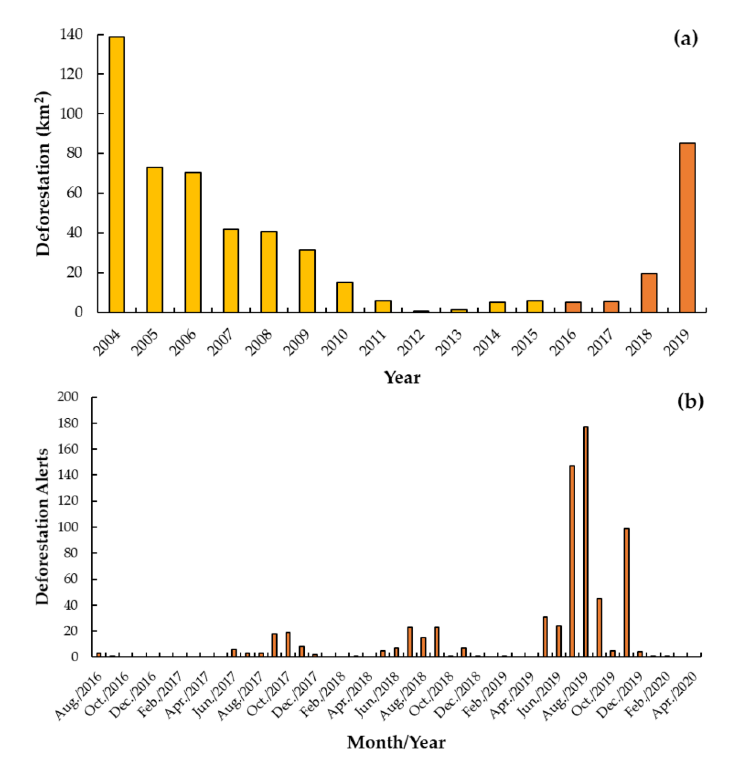
The fire emitted aerosol species chosen to be associated with deforestation in the study area was PM2.5, since it is a good tracer for other aerosols and trace gases emitted from fires and in the meantime detrimental for human health [52,53].
The annual PM2.5 emitted from fires for the 2004–2019 period was estimated using the Brazilian biomass burning emission model with fire radiative power (3BEM_FRP) implemented on the PREP-CHEM-SRC emissions preprocessing tool version 1.8.3 [54]. For studies conducted in South America, this model has the advantage of being parameterized for the continent (and region) relative to global biomass burning inventories [55], while enabling the estimation of emissions on flexible spatial resolutions [56]. MODIS active fires collection 6 products (MOD14 and MYD14) [57] were the only data inputs in the 3BEM_FRP model, and fires were the only source of emission activated in PREP-CHEM-SRC 1.8.3. The outputs generated consisted of the daily emission of several aerosol pollutant species at the spatial resolution of 0.1 degree. Daily estimates of PM2.5 coverages were isolated in the Apyterewa Indigenous Land and tallied to provide annual values. More details on the model and tool used are described in Pereira et al. [54], Santos [55] and Freitas et al. [56], while the application of this method is fully described in Mataveli et al. [28].
Here, we highlight that it is often difficult to estimate the fire radiative power for each active fire detected by the MOD14 and MYD14 products, and this may introduce uncertainties to final estimates of fire emissions. This includes the misdetection of small size or less intense fires and failure of detection of fires because of cloud cover or smoke, and the reduced sensitivity of MODIS sensors for detecting active fires and estimating the fire radiate power accurately at off-nadir viewing angles [58,59,60].

3. Results

3.1. Land Use and Land Cover
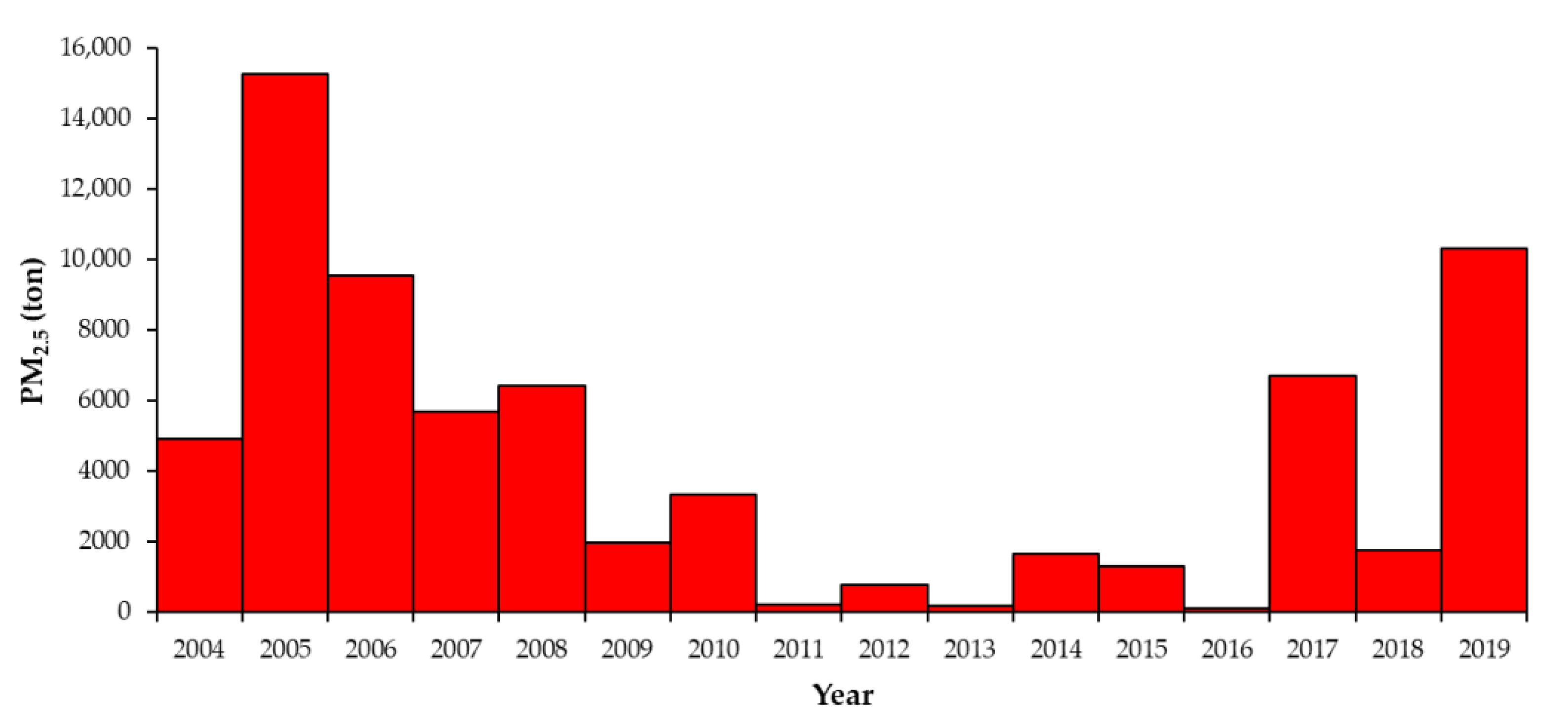
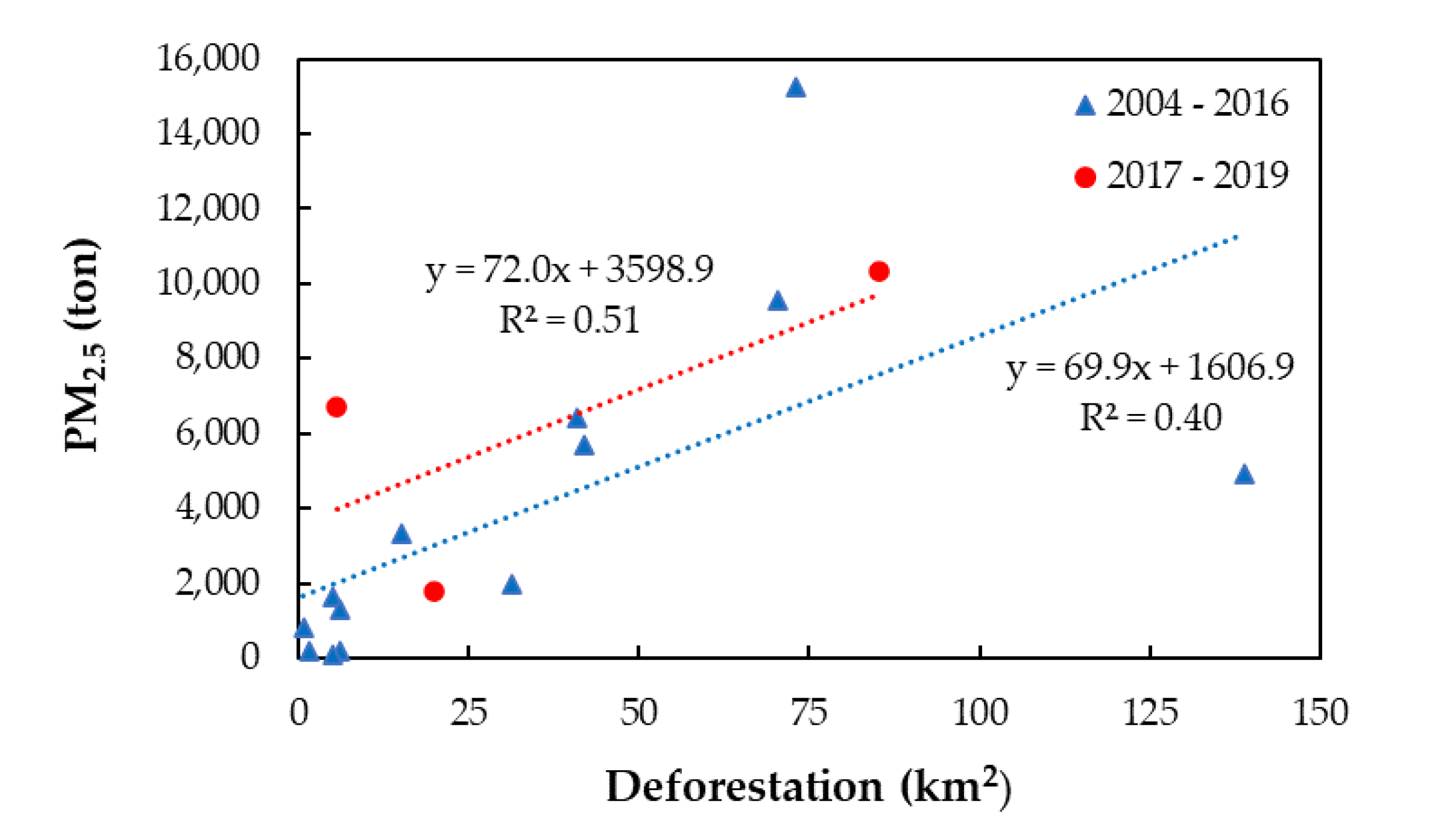
By comparing the 2016 and 2019 LULC classifications (Figure 2), we could observe substantial differences directly related to the conversion of natural areas to anthropized ones, which represents the advance of deforestation within the study area.
In 2016, the anthropized areas (pasture, mining, agriculture and other human activities) represented 362 km2, totalling 4.7% of the Apyterewa Indigenous Land. The natural areas (forest and outcrop rocks) and water corresponded to 7365 km2 (95.2%) and 12 km2 (0.1%), respectively. In 2019, the anthropized areas increased to 570 km2, an increment of more than 200 km2, totalling 7.4% of the study area. Natural areas decreased in proportion, corresponding to 7154 km2 (92.4%). Water bodies also increased in area, adding 14 km2, or 0.2%. These results are summarized in Table 1.
This pattern agrees with the information provided by Brazilian official deforestation data from INPE but the accumulated deforestation from 2016 and 2019 via the GEOBIA approach was significantly higher than PRODES (more than 100 km2). For Apyterewa, PRODES detected a reduction of the annual deforestation rate after the legal demarcation of this indigenous land in 2007; however, an abrupt increase was detected in recent years, especially in 2019 [21]. A gradual increase between 2016 and 2018 was also apparent, followed by a conversion boom in 2019 (Figure 3a). Deforestation alerts emitted by DETER also showed an increase in 2019, specifically in July/August. Moreover, these data suggest that deforestation in the Apyterewa Indigenous Land was mostly occurring during the dry season (usually between May and October; Figure 3b).

3.2. Fire Emissions

The recent deforestation boom in the Apyterewa Indigenous Land has sharply increased fire associated PM2.5 aerosol pollutant emissions (Figure 4). The fire emission results for Apyterewa between the beginning of the deforestation-stemming interventions by the Brazilian federal government and non-governmental organizations (NGOs) aimed at reducing deforestation in the Brazilian Amazon (2004) [61] and the beginning of the new deforestation boom (2016) have shown an annual average emission of PM2.5 of 3954 ton year−1. In the recent era of increasing agricultural incursions (2017–2019), the average estimated emission was 6258 ton year−1, an increase of approximately 58% in the annual average of PM2.5 associated with fires of the 2004–2016 period. This is in agreement with the results obtained from the LULC classifications (Figure 2), which showed an increase in deforestation and, consequently, the conversion to anthropized land-uses in the Apyterewa Indigenous Land between 2016 and 2019.
According to PRODES data, deforestation started decreasing yearly since 2004 (139 km2), reached the lowest value in 2012 (0.77 km2), and ranged between 1.63 and 6.02 km2 during 2013–2016 but started increasing again after 2016, reaching 85.25 km2 in 2019 (Figure 3). By comparing the annual PM2.5 fire emissions time series (Figure 4) with the annual deforestation rates estimated by INPE [21] (Figure 3a), we could see similar but not strong linearly correlated patterns (Figure 5). This decoupling is related, among others, to the fact that deforestation does not always utilize fire for removing the natural vegetation, and that the fire is also used as a tool to manage already converted pastures and agricultural fields (i.e., deforestation that occurred in previous years). Evidence of fire emission drivers will be addressed in the Discussion section.

4. Discussion

As stated before, we used existing INPE data to compare an annual time series of deforestation estimates to model annual particulate emissions from fire. We additionally used a LULC approach with finer resolution to more completely characterize deforestation in the area.
Overall, the GEOBIA approach showed that land conversion from deforestation incursion into the Apyterewa Indigenous Land has increased dramatically—up over 200 km2 in 2019 compared to 2016 rates—in the recent era of increased exploitation in the Brazilian Amazon. Increases of forest loss from fire-drought related events cannot explain this upturn since no such anomalous rainfall conditions have been observed in this area [5]; furthermore, our approach clearly identifies LULC classes, allowing attribution to factors other than natural or climate change related disturbances, as we will explore in the following sections. Since LULC changes are frequently associated with fire in the Amazon, direct greenhouse gas emissions and aerosol pollutants are a major component of the ecological impact of these changes. Additionally, indeed, we found a major uptick in suspected fine particulate PM2.5 that may have contributed generally to the air quality crises inside and outside of the Amazon in 2019 [62]. Figure 6 exemplifies the intrinsic relationship between fire and the deforestation process in the Amazon; that is, after the forest is clear-cut it is left to dry then burned to prepare for the conversion to agriculture or pasture. Sometimes this fire escapes into forests. In this illustration it is possible to observe burned pastures, agricultural fields, and forests by analyzing its spectral characteristics (features appear dark in the OLI/Landsat-8 images).

4.1. Land Use and Land Cover Changes and Drivers in the Apyterewa Indigenous Land

The deforestation and land conversion dynamics displayed by our detailed classification (GEOBIA) and by the Brazilian Space Agency monitoring programs PRODES and DETER followed a similar pattern. However, during the period analyzed, the classification via GEOBIA identified 100.25 km2 more deforestation than the PRODES official data. This can be explained by the differences between contextual (geo-objects) and pixel-based classification methods and by the interpretation key used. The classification via GEOBIA defined the ongoing forest degradation as an anthropized area, which was done taking into consideration the spatial resolution of the OLI/Landsat-8 images (0.001 km2). Although PRODES deforestation areas are collected at 0.001 km2, this official data considers as smaller deforestation size 0.0625 km2 to maintain consistency with long-term data. With this, PRODES may consider selective logging or “forests under use” not necessarily deforestation, which is, therefore, represented only by clear-cut events. Besides not accounting for degradation processes (which may inflate small deforestation estimates) [63], PRODES also considers an exclusion mask containing the deforestation from previous years to eliminate the possibility of old deforestation being mapped again [21]. These are the main factors that may have caused differences between PRODES and our GEOBIA product. We also note here that, according to [63], the increasingly small size of deforestation patches in Brazil, less likely detected by PRODES or DETER, may also partially reflect attempts by larger landowners to evade monitoring of deforestation activities. Finally, there was less open water observed in 2016 than 2019 in our GEOBIA analysis. The difference in the class Water was not significant, but the smaller area in 2016 could be explained by the extreme drought event in the Amazon during the course of the El Niño 2015–2016 event [64]. No large water bodies are identified within Apyterewa, which can be seen in Figure 2.
The loss of natural areas (here, especially forests) and increase of anthropized areas are tightly coupled in Amazon LULC dynamics and extremely common in the Xingu River basin, where the Apyterewa Indigenous Land is located, due to the pressure of agricultural activities on protected areas [22,65]. In this region, land grabbers and settlers enter protected areas for timber harvesting and/or implement cattle ranching and agricultural activities [15,66]. As mentioned before, the extensive livestock production is the major deforestation driver in this region, where pasturelands expand as a response to the economic value of land [67] and the increasing beef exportation [68]. International markets for Brazilian beef are opening again and exportation is returning to increase after the meat inspection scandal that led traders to ban Brazilian meat in 2017 [69,70]. Related to this, the agricultural sector has been profitable in recent years [71], especially soybean exportation [72]. This process indirectly affects the region where Apyterewa is located: the advance of soybean into former cattle pastures in the state of Mato Grosso has induced ranchers to sell their land and reinvest their money in buying and clearing forest areas where land is cheaper, deeper in the Amazon region [69,73], especially in the state of Pará [68,70,72].
From the LULC classifications, it was possible to observe that the Apyterewa Indigenous Land has most of the anthropized areas located close to its southern border (Figure 2), reflecting a migratory flux from the nearby state of Mato Grosso. The border closer to Mato Grosso was the most deforested area within Apyterewa in 2016 and showed an expressive increase in 2019. According to INPE deforestation increment data, Apyterewa was the third most deforested indigenous land in the Brazilian Amazon during the 2018 and 2019 period, and São Félix do Xingu had the second largest deforestation rate among the municipalities of the Brazilian Amazon in the same period [21]. The boom of deforestation alerts in July 2019 (Figure 3b) was also detected by other monitoring systems developed by NGOs [74,75,76,77]. It should also be mentioned that deforestation in 2019 must be even higher than the estimates obtained from the GEOBIA approach, since the image classified was obtained in July/2019 but several deforestation alerts were emitted from August 2019 to December 2019 (Figure 3b). Nevertheless, these values are comparable to PRODES because of the calendar adopted in this official data (ending in July as previously described).
This increase in deforestation is also related to land conflicts. São Félix do Xingu is a municipality exceeding 85,000 km2; more than 70% of this municipality is protected by law (45,000 km2 for indigenous lands and 16,000 km2 for other protected areas). Nevertheless, the largest cattle herd in Brazil is located in this municipality [78], leading to the aforementioned land conflicts. The demarcation of protected areas is essential for their preservation as forest and indigenous territory offering dual protection of human rights and traditional cultural heritage and practice and conservation and ecosystem services of intact rainforest. Legal and well-defined initiatives can curb the advance of deforestation into indigenous lands, enhancing overall protection [79]. However, public policies to curb deforestation and environmental inspections are key elements to guarantee positive outcomes [80,81]. As observed by the occupation pattern in Apyterewa, this has not been respected. Literature shows a recent increasing trend in deforestation rates among the indigenous lands and protected areas of the Xingu corridor [22,36]. This arises from the pressure derived from the land occupation process that is characteristic of the eastern region of Pará [71,82], which moves small and medium-sized farmers expelled by landowners towards increasingly remote areas. Furthermore, the pressure of livestock and crop expansion on protected areas is magnified when headwaters of the important Xingu river system lie outside of protected areas, leading to watershed degradation [83,84]. Certain indigenous and political factions are defending the expansion of agriculture within indigenous lands [85,86]; however, the production of soybean and cotton, for example, will increase the need for agrochemicals that may affect the Xingu river and soil, causing the mortality of fishes and the alteration of soil properties. Moreover, the resulting pollution may affect the indigenous communities living inside the land [87].
In addition to agricultural and cattle practices, the insecurity of property rights in this region is another factor contributing to deforestation. Indigenous landowners such as the Parakanã, ancestral people of Apyterewa, even being protected by law, have limited resources to fight against illegal timber harvesting, and deforestation is a general consequence [88]. Indigenous lands are historically focused solely on the land within their legal boundaries, not outside, and, therefore, they do not consider the neighbouring areas of influence [89].
The weakening of environmental law enforcement is coincident with the observed increase in LULC changes and deforestation in this indigenous land, and the region generally, after 2018 [34,74,76]. This municipality has been a major deforestation frontier, driven almost exclusively by the expansion of cattle ranching in a continuous and pervasive cycle of land degradation, abandonment and new land conversion [78]. Currently, the consequence of depleting forest in the non-protected municipality area with pasturelands has translated to pressure for illegal timber harvesting within protected areas, leading to the advance of illegal deforestation in Apyterewa and other local indigenous lands [90].
The pattern of occupation in Apyterewa agrees with the one explained by Schwartzman et al. [65] for indigenous lands of the Xingu River basin, with more pressure and occupation in the borders and areas proximal to rivers. In the specific case of Apyterewa, it is observed that the occupation pattern is more concentrated in the southeastern portion, which is surrounded by agricultural fields in proximity to the urban areas. It is also noted an expansion from the southeast to the west (in direction to the Xingu River) and north (in direction to the municipality of Altamira). The expansion of infrastructure vectors such as small roads and paving projects have been advancing logging, mining and land speculation in these areas [12,15]. This often spurs a large network of irregular roads into dense forests as a result of the concurrent interests of migrant farmers and loggers to move the forest frontiers [15].
There has been an increase in the formation of pasturelands (or “glebas”, i.e., organized conjuncts of fields suitable for pasture management) within Apyterewa. By the LULC interpretation key used in this work based on Coutinho et al. [47], these areas primarily represent cattle ranching and with a minority crop agriculture. We highlighted that few of these pasturelands areas were associated with other forms of degradation in the São Félix do Xingu region [78] related to patterns of settlement and land grabbing. As previously discussed, the major deforestation driver in Apyterewa is the LULC conversion from forest to pasturelands; however, among the polygons of Anthropized areas, we also detected an increase in mining, especially in the western and southwestern portion of the study area, on the edges of the Xingu River and its affluent São Sebastião stream, respectively. From 2017 to 2019, official deforestation alerts detected 11 polygons related to mining activities within Apyterewa [21]. Mining activities are expanding in the Amazon, including the Xingu River basin, and indigenous lands such as Apyterewa, that include or are adjacent to river systems [74].
As our results showed, agriculture and forest loss have been expanding significantly within the Apyterewa Indigenous Land. To reverse this scenario of deforestation within Apyterewa and other indigenous lands, it is essential to increase the value of the standing forest compared to other land-uses that require deforestation [91] and reinvigorate robust monitoring to enforcement procedures developed and utilized in the recent past. This crisis is occurring at a moment when the Amazon forest broadly is at risk of passing a climate tipping point [22,92] from which the forest may not be able to recover [93]. Even so, the Brazilian Amazon is not deeply involved in projects for promoting sustainable development and forest preservation [94]. To date, conservation initiatives have spread more through top-down enforcement policies than from positive local interventions and incentives in the Brazilian Amazon [95]. Exploiting strategies to generate economic benefits for ranchers from maintaining standing forest could mitigate deforestation inside and outside Apyterewa and other protected areas of the Amazon. This strategy can be important for stimulating sustainable livestock practices, boosting productivity, avoiding deforestation, reducing environmental liabilities in a traditionally underperforming sector and promoting social and economic justice for rural peoples [78,79].

4.2. Fire Emissions in the Apyterewa Indigenous Land

The consequences of deforestation and LULC changes within the Apyterewa Indigenous Land, and throughout the Amazon are linked to regional-wide and global atmospheric processes. To highlight this we traced the expected emissions of harmful fine particulate aerosols produced by the burning of forests for agricultural conversion. While aerosol pollutants are an atmospheric risk of land conversion [96], intact Amazon forest provides environmental services of cooling the regional and global atmosphere [97], regulating regional and interregional climate circulation patterns [8], and transporting water/precipitation throughout the South American continent [98] that are also severely threatened by deforestation. Considering our case of fine pollutants, as expected, as deforestation fell through the 2000s and was low in the 2010s the average emissions of PM2.5 pollutants were low. Particularly between 2011 and 2016, the average PM2.5 emission from fires was just 709 ton year−1. However, along with the recent spike in deforestation, fire emitted pollutants have soared, with estimated PM2.5 emissions reaching over 10,000 tons in 2019. Nonetheless, it is important to highlight that deforestation and fire emission estimates, driven directly by remote sensing products sensitive to fire, are not strong linearly correlated, as observed in Figure 5. This helps highlight that deforestation does not always utilize fire for removing the natural vegetation, and/or fire intensity and extent may vary relative to the total area ultimately converted, potentially in part because of forest incursion fires [99]. On the other hand, there are also other fire emission drivers that may act besides deforestation, such as the use of fire for hunting purposes by the local communities, cleaning crop residues after harvest, pest control or managing pasture lands (i.e., prescribed burnings for enhancing regrowth) [26,100,101]. Accordingly, the work of Morgan et al. [102] showed that non-deforestation fire drivers are increasingly important sources of emissions in the Amazon.
The 21st century drought events in the Amazon (years 2005, 2010 and 2015/2016) may have favored the occurrence of fires and even likely counteracted declines in deforestation carbon emissions during this period [99]. We observed this markedly in the annual expected PM2.5 fire emissions of 2005, when estimates were the highest (15,238 ton), approximately 247% of the annual average found for the 2004–2019 period (4386 ton year−1). No clear association was found between fire emissions and the droughts of 2010 and 2015/2016. Here, we note that the expected increase in droughts and heatwaves in the Amazon under climate change may also interact with the land conversion in the Apyterewa Indigenous Land to drive forest towards a long-term low biomass savanna or savanna-like state [32,103]. Such savannization may be of particular concern in drier amazon forest regions such as the upper Xingu where there are five or more dry season months a year and less than 2000 mm of precipitation annually [30]. Thus, the 2018 and 2019 marked increase in forest loss in Apyterewa may interact with climate change by creating more fire prone microclimate conditions during drought, creating a fire cycle, and degrading the forest more severely in the future [31], unless counteracted by forest restoration [104]. Here we note that future studies should focus on understanding the relationship between precipitation, air temperature and fire emissions over the Amazon basin and how they affect different regions, for example, in terms of severe drought events.

5. Conclusions

In this study we evaluated the relationships between deforestation, LULC drivers and fire emissions in the Apyterewa Indigenous Land, Eastern Brazilian Amazon. We observed a remarkable advance of deforestation within the study area in the past three years (200 km2) via the GEOBIA approach. In 2016, the anthropized areas represented 4.7% of the Apyterewa Indigenous Land, while the natural areas corresponded to 95.3%. Three years after, in 2019, the anthropized areas increased to 7.4% of the study area, while the natural areas were reduced to 92.6%. Regarding the fire emissions of harmful aerosol pollutants, between 2004 and 2016 the annual average predicted emission of PM2.5 emitted from fires was 3954 ton year−1, while the recent period of enhanced exploitation (2017–2019) had an average of 6258 ton year−1. The annual average of PM2.5 associated with fires increased approximately 58% in the study period, contributing to the air quality crisis in Brazil in late 2019.
The advance of the agricultural frontier is occurring within the Apyterewa Indigenous Land, having significant atmospheric consequences, which are highlighted by the increasing PM2.5 aerosol pollutant emissions from fire. These results expose a critical situation within “protected areas” in the Brazilian Amazon. In order to reverse this destructive scenario, it is important to develop strategies to preserve the standing forests that reflect their highly significant global and regional ecosystem service values, including the carbon sink, the protection of human health from harmful fire-produced aerosol and other pollutants, and other long-term economic potentials. Strategies should include supporting sustainable egalitarian livestock and agricultural economies and practices in order to reduce environmental liabilities in these traditionally underperforming sectors. These strategies are crucial not only to avoid deforestation but are also of utmost importance to mitigate the environmental and ecological impacts caused by forest loss and associated fire. The most robust response would also address the threat of forest loss and savannization degradation feedback by promoting forest regrowth in degraded preserves.

Author Contributions

Conceptualization, G.d.O., G.A.V.M. and M.E.D.C.; methodology, G.d.O., G.A.V.M. and M.E.D.C.; writing—original draft preparation, G.d.O., G.A.V.M., M.E.D.C., H.T.S. and F.d.S.C.; writing—review and editing, J.M.C., Y.E.S., L.H., S.C.S. and C.A.C.d.S. All authors have read and agreed to the published version of the manuscript.

Funding

G.A.V.M. acknowledges funding from the National Council for Scientific and Technological Development (CNPq, grant number 381065/2019) and M.E.D.C. acknowledges funding from the Coordination for the Improvement of Higher Education Personnel (CAPES, grant number 88887.351470/2019-00). C.A.C.S. also acknowledges CNPq for providing a Research Productivity Grant (grant number 304493/2019-8). S.C.S. is supported by United States Department of Agriculture (USDA), National Institute of Food and Agriculture (NIFA) and National Science Foundation (NSF) awards (grant numbers DEB-1950080, EF-1340604, 1550686, and DEB-1754357).

Conflicts of Interest

The authors declare no conflict of interest.

References

  1. Watson, J.E.M.; Evans, T.; Venter, O.; Williams, B.; Tulloch, A.; Stewart, C.; Thompson, I.; Ray, J.C.; Murray, K.; Salazar, A.; et al. The exceptional value of intact forest ecosystems. Nat. Ecol. Evol. 2018, 2, 599–610. [Google Scholar] [CrossRef] [PubMed]
  2. Nolte, C.; Agrawal, A.; Silvius, K.M.; Soares-Filho, B.S. Governance regime and location influence avoided deforestation success of protected areas in the Brazilian Amazon. Proc. Natl. Acad. Sci. USA 2013, 110, 4956–4961. [Google Scholar] [CrossRef] [PubMed] [Green Version]
  3. Van der Werf, G.R.; Randerson, J.T.; Giglio, L.; van Leeuwen, T.T.; Chen, Y.; Rogers, B.M.; Mu, M.; van Marle, M.J.E.; Morton, D.C.; Collatz, G.J.; et al. Global fire emissions estimates during 1997–2016. Earth Syst. Sci. Data 2017, 9, 697–720. [Google Scholar] [CrossRef] [Green Version]
  4. Amaral, S.S.; Costa, M.A.M.; Soares Neto, T.G.; Costa, M.P.; Dias, F.F.; Anselmo, E.; Santos, J.C.D.; Carvalho, J.A., Jr. CO2, CO, hydrocarbon gases and PM2.5 emissions on dry season by deforestation fires in the Brazilian Amazonia. Environ. Pollut. 2019, 249, 311–320. [Google Scholar] [CrossRef]
  5. Barlow, J.; Berenguer, E.; Carmenta, R.; Franca, F. Clarifying Amazonia’s burning crisis. Glob. Chang. Biol. 2020, 26, 319–321. [Google Scholar] [CrossRef] [Green Version]
  6. Bullock, E.L.; Woodcock, C.E.; Souza, C., Jr.; Olofsson, P. Satellite-based estimates reveal widespread forest degradation in the Amazon. Glob. Chang. Biol. 2020, 26, 2956–2969. [Google Scholar] [CrossRef]
  7. Vieira, I.C.; Toledo, P.M.; Silva, J.M.; Higuchi, H. Deforestation and threats to the biodiversity of Amazonia. Braz. J. Biol. 2008, 68, 949–956. [Google Scholar] [CrossRef] [Green Version]
  8. Garcia, E.S.; Swann, A.L.; Villegas, J.C.; Breshears, D.D.; Law, D.J.; Saleska, S.R.; Stark, S.C. Synergistic Ecoclimate Teleconnections from Forest Loss in Different Regions Structure Global Ecological Responses. PLoS ONE 2016, 11, e0165042. [Google Scholar] [CrossRef] [Green Version]
  9. Spracklen, D.V.; Garcia-Carreras, L. The impact of Amazonian deforestation on Amazon basin rainfall. Geophys. Res. Lett. 2015, 42, 9546–9552. [Google Scholar] [CrossRef] [Green Version]
  10. Zemp, D.C.; Schleussner, C.F.; Barbosa, H.M.J.; Rammig, A. Deforestation effects on Amazon forest resilience. Geophys. Res. Lett. 2017, 44, 6182–6190. [Google Scholar] [CrossRef] [Green Version]
  11. Alves, L.M.; Marengo, J.A.; Fu, R.; Bombardi, R.J. Sensitivity of Amazon Regional Climate to Deforestation. Am. J. Clim. Change 2017, 6, 75–98. [Google Scholar] [CrossRef] [Green Version]
  12. Schielein, J.; Börner, J. Recent transformations of land-use and land-cover dynamics across different deforestation frontiers in the Brazilian Amazon. Land Use Policy 2018, 76, 81–94. [Google Scholar] [CrossRef]
  13. Souza, C.; Kirchhoff, F.; Oliveira, B.; Ribeiro, J.; Sales, M. Long-Term Annual Surface Water Change in the Brazilian Amazon Biome: Potential Links with Deforestation, Infrastructure Development and Climate Change. Water 2019, 11, 566. [Google Scholar] [CrossRef] [Green Version]
  14. Staal, A.; Flores, B.M.; Aguiar, A.P.D.; Bosmans, J.H.C.; Fetzer, I.; Tuinenburg, O.A. Feedback between drought and deforestation in the Amazon. Environ. Res. Lett. 2020, 15, 044024. [Google Scholar] [CrossRef]
  15. Jusys, T. Fundamental causes and spatial heterogeneity of deforestation in Legal Amazon. Appl. Geogr. 2016, 75, 188–199. [Google Scholar] [CrossRef]
  16. Barber, C.P.; Cochrane, M.A.; Souza, C.M.; Laurance, W.F. Roads, deforestation, and the mitigating effect of protected areas in the Amazon. Biol. Conserv. 2014, 177, 203–209. [Google Scholar] [CrossRef]
  17. Assunção, J.; Gandour, C.; Rocha, R. Deforestation slowdown in the Brazilian Amazon: Prices or policies? Environ. Dev. Econ. 2015, 20, 697–722. [Google Scholar] [CrossRef] [Green Version]
  18. Spracklen, B.D.; Kalamandeen, M.; Galbraith, D.; Gloor, E.; Spracklen, D.V. A Global Analysis of Deforestation in Moist Tropical Forest Protected Areas. PLoS ONE 2015, 10, e0143886. [Google Scholar] [CrossRef]
  19. Arima, E.Y.; Barreto, P.; Araújo, E.; Soares-Filho, B. Public policies can reduce tropical deforestation: Lessons and challenges from Brazil. Land Use Policy 2014, 41, 465–473. [Google Scholar] [CrossRef]
  20. Nepstad, D.; Soares-Filho, B.S.; Merry, F.; Lima, A.; Moutinho, P.; Carter, J.; Bowman, M.; Cattaneo, A.; Rodrigues, H.; Schwartzman, S.; et al. Environment. The end of deforestation in the Brazilian Amazon. Science 2009, 326, 1350–1351. [Google Scholar] [CrossRef]
  21. National Institute for Space Research (INPE). Monitoring of the Brazilian Amazon Deforestation by Satellite. 2020. Available online: http://www.obt.inpe.br/OBT/assuntos/programas/amazonia/prodes (accessed on 14 April 2020).
  22. Amigo, I. When will the Amazon hit a tipping point? Nature 2020, 578, 505–507. [Google Scholar] [CrossRef] [PubMed] [Green Version]
  23. Ferrante, L.; Fearnside, P.M. Brazil’s new president and ‘ruralists’ threaten Amazonia’s environment, traditional peoples and the global climate. Environ. Conserv. 2019, 46, 261–263. [Google Scholar] [CrossRef]
  24. Carvalho, W.D.; Mustin, K.; Hilário, R.R.; Vasconcelos, I.M.; Eilers, V.; Fearnside, P.M. Deforestation control in the Brazilian Amazon: A conservation struggle being lost as agreements and regulations are subverted and bypassed. Perspect. Ecol. Conserv. 2019, 17, 122–130. [Google Scholar] [CrossRef]
  25. Herrera, D.; Pfaff, A.; Robalino, J. Impacts of protected areas vary with the level of government: Comparing avoided deforestation across agencies in the Brazilian Amazon. Proc. Natl. Acad. Sci. USA 2019, 116, 14916–14925. [Google Scholar] [CrossRef] [Green Version]
  26. Pivello, V.R. The Use of Fire in the Cerrado and Amazonian Rainforests of Brazil: Past and Present. Fire Ecol. 2011, 7, 24–39. [Google Scholar] [CrossRef]
  27. Van der Werf, G.R.; Morton, D.C.; DeFries, R.S.; Giglio, L.; Randerson, J.T.; Collatz, G.J.; Kasibhatla, P.S. Estimates of fire emissions from an active deforestation region in the southern Amazon based on satellite data and biogeochemical modelling. Biogeosciences 2009, 6, 235–249. [Google Scholar] [CrossRef] [Green Version]
  28. Mataveli, G.A.V.; Silva, M.E.S.; França, D.D.A.; Brunsell, N.A.; de Oliveira, G.; Cardozo, F.D.S.; Bertani, G.; Pereira, G. Characterization and Trends of Fine Particulate Matter (PM2.5) Fire Emissions in the Brazilian Cerrado during 2002–2017. Remote Sens. 2019, 11, 2254. [Google Scholar] [CrossRef] [Green Version]
  29. Schweizer, D.; Cisneros, R.; Navarro, K. The effectiveness of adding fire for air quality benefits challenged: A case study of increased fine particulate matter from wilderness fire smoke with more active fire management. For. Ecol. Manag. 2020, 458, 117761. [Google Scholar] [CrossRef]
  30. Malhi, Y.; Aragao, L.E.; Galbraith, D.; Huntingford, C.; Fisher, R.; Zelazowski, P.; Sitch, S.; McSweeney, C.; Meir, P. Exploring the likelihood and mechanism of a climate-change-induced dieback of the Amazon rainforest. Proc. Natl. Acad. Sci. USA 2009, 106, 20610–20615. [Google Scholar] [CrossRef] [Green Version]
  31. Cochrane, M.A.; Laurance, W.F. Synergisms among fire, land use, and climate change in the Amazon. Ambio 2008, 37, 522–527. [Google Scholar] [CrossRef]
  32. Hirota, M.; Holmgren, M.; van Nes, E.H.; Scheffer, M. Global resilience of tropical forest and savanna to critical transitions. Science 2011, 334, 232–235. [Google Scholar] [CrossRef] [PubMed] [Green Version]
  33. Brando, P.M.; Soares-Filho, B.; Rodrigues, L.; Assuncao, A.; Morton, D.; Tuchschneider, D.; Fernandes, E.C.M.; Macedo, M.N.; Oliveira, U.; Coe, M.T. The gathering firestorm in southern Amazonia. Sci. Adv. 2020, 6, eaay1632. [Google Scholar] [CrossRef] [PubMed] [Green Version]
  34. Instituto Socioambiental (ISA). Indigenous Lands in Brazil. 2020. Available online: https://terrasindigenas.org.br/es/terras-indigenas/3585 (accessed on 20 April 2020).
  35. Gaworecki, M. Pasture expansion driving deforestation in Brazilian protected area. 2018. Available online: https://news.mongabay.com/2018/10/pasture-expansion-driving-deforestation-in-brazilian-protected-area/ (accessed on 20 April 2020).
  36. Escobar, H. Brazil’s deforestation is exploding—and 2020 will be worse. Science 2019. [Google Scholar] [CrossRef]
  37. United States Geological Survey (USGS). Global Visualization Viewer (GloVis). 2020. Available online: http://glovis.usgs.gov/ (accessed on 20 April 2020).
  38. Blaschke, T. Object based image analysis for remote sensing. ISPRS J. Photogram. 2010, 65, 2–16. [Google Scholar] [CrossRef] [Green Version]
  39. Ye, S.; Pontius, R.G.; Rakshit, R. A review of accuracy assessment for object-based image analysis: From per-pixel to per-polygon approaches. ISPRS J. Photogram. 2018, 141, 137–147. [Google Scholar] [CrossRef]
  40. Espindola, G.M.; Camara, G.; Reis, I.A.; Bins, L.S.; Monteiro, A.M. Parameter selection for region-growing image segmentation algorithms using spatial autocorrelation. Int. J. Remote Sens. 2007, 27, 3035–3040. [Google Scholar] [CrossRef]
  41. Pal, M.; Foody, G.M. Feature Selection for Classification of Hyperspectral Data by SVM. IEEE Trans. Geosci. Remote Sens. 2010, 48, 2297–2307. [Google Scholar] [CrossRef] [Green Version]
  42. Rouse, J.W.; Hass, R.H.S.; Schell, J.A.; Deering, D.W. Monitoring vegetation systems in the Great Plains with ERTS. In Proceedings of the 3rd ERTS Symposium, Washington, DC, USA, 10–14 December 1973. [Google Scholar]
  43. Huete, A.R. A soil-adjusted vegetation index (SAVI). Remote Sens. Environ. 1988, 25, 295–309. [Google Scholar] [CrossRef]
  44. Gao, B.-C. NDWI—A normalized difference water index for remote sensing of vegetation liquid water from space. Remote Sens. Environ. 1996, 58, 257–266. [Google Scholar] [CrossRef]
  45. Khiali, L.; Ienco, D.; Teisseire, M. Object-oriented satellite image time series analysis using a graph-based representation. Ecol. Inform. 2018, 43, 52–64. [Google Scholar] [CrossRef] [Green Version]
  46. Lucieer, A.; Stein, A. Existential uncertainty of spatial objects segmented from satellite sensor imagery. IEEE Trans. Geosci. Remote Sens. 2002, 40, 2518–2521. [Google Scholar] [CrossRef] [Green Version]
  47. Coutinho, A.C.; Almeida, C.; Venturieri, A.; Esquerdo, J.C.D.M.; Silva, M. Uso e Cobertura da Terra Nas Áreas Desflorestadas da Amazônia Legal: TerraClass 2008; EMBRAPA: Brasília, Brazil, 2013. [Google Scholar]
  48. Sanchez, A.H.; Picoli, M.C.A.; Camara, G.; Andrade, P.R.; Chaves, M.E.D.; Lechler, S.; Soares, A.R.; Marujo, R.F.B.; Simões, R.E.O.; Ferreira, K.R.; et al. Comparison of Cloud Cover Detection Algorithms on Sentinel–2 Images of the Amazon Tropical Forest. Remote Sens. 2020, 12, 1284. [Google Scholar] [CrossRef] [Green Version]
  49. Mathur, A.; Foody, G.M. Crop classification by support vector machine with intelligently selected training data for an operational application. Int. J. Remote Sens. 2008, 29, 2227–2240. [Google Scholar] [CrossRef] [Green Version]
  50. Mountrakis, G.; Im, J.; Ogole, C. Support vector machines in remote sensing: A review. ISPRS J. Photogram. 2011, 66, 247–259. [Google Scholar] [CrossRef]
  51. Jiang, Z.; Shekhar, S.; Zhou, X.; Knight, J.; Corcoran, J. Focal-Test-Based Spatial Decision Tree Learning. IEEE Trans. Knowl. Data Eng. 2015, 27, 1547–1559. [Google Scholar] [CrossRef]
  52. Bai, Y.; Brugha, R.E.; Jacobs, L.; Grigg, J.; Nawrot, T.S.; Nemery, B. Carbon loading in airway macrophages as a biomarker for individual exposure to particulate matter air pollution-A critical review. Environ. Int. 2015, 74, 32–41. [Google Scholar] [CrossRef]
  53. Rafael, S.; Tarelho, L.; Monteiro, A.; Sa, E.; Miranda, A.I.; Borrego, C.; Lopes, M. Impact of forest biomass residues to the energy supply chain on regional air quality. Sci. Total Environ. 2015, 505, 640–648. [Google Scholar] [CrossRef]
  54. Pereira, G.; Siqueira, R.; Rosário, N.E.; Longo, K.L.; Freitas, S.R.; Cardozo, F.S.; Kaiser, J.W.; Wooster, M.J. Assessment of fire emission inventories during the South American Biomass Burning Analysis (SAMBBA) experiment. Atmos. Chem. Phys. 2016, 16, 6961–6975. [Google Scholar] [CrossRef] [Green Version]
  55. Santos, P.R. Desenvolvimento e Implementação do Ciclo Diurno da Queima de Biomassa no PREP-CHEM-SRC: Análise dos Inventários de Emissões de Aerossóis na América do Sul. Master’s Thesis, National Institute for Space Research, São José dos Campos, Brazil, 2018. [Google Scholar]
  56. Freitas, S.R.; Longo, K.M.; Alonso, M.F.; Pirre, M.; Marecal, V.; Grell, G.; Stockler, R.; Mello, R.F.; Sánchez Gácita, M. PREP-CHEM-SRC–1.0: A preprocessor of trace gas and aerosol emission fields for regional and global atmospheric chemistry models. Geosci. Model Dev. 2011, 4, 419–433. [Google Scholar] [CrossRef] [Green Version]
  57. Giglio, L.; Schroeder, W.; Justice, C.O. The collection 6 MODIS active fire detection algorithm and fire products. Remote Sens. Environ. 2016, 178, 31–41. [Google Scholar] [CrossRef] [Green Version]
  58. Ichoku, C.; Kahn, R.; Chin, M. Satellite contributions to the quantitative characterization of biomass burning for climate modeling. Atmos. Res. 2012, 111, 1–28. [Google Scholar] [CrossRef] [Green Version]
  59. Wang, J.; Yue, Y.; Wang, Y.; Ichoku, C.; Ellison, L.; Zeng, J. Mitigating Satellite-Based Fire Sampling Limitations in Deriving Biomass Burning Emission Rates: Application to WRF-Chem Model Over the Northern sub-Saharan African Region. J. Geophys. Res. Atmos. 2018, 123, 507–528. [Google Scholar] [CrossRef] [Green Version]
  60. Tang, W.; Arellano, A.F. Investigating dominant characteristics of fires across the Amazon during 2005-2014 through satellite data synthesis of combustion signatures. J. Geophys. Res. Atmos. 2017, 122, 1224–1245. [Google Scholar] [CrossRef]
  61. Richards, P.; Arima, E.; VanWey, L.; Cohn, A.; Bhattarai, N. Are Brazil’s Deforesters Avoiding Detection? Conserv. Lett. 2017, 10, 470–476. [Google Scholar] [CrossRef] [PubMed]
  62. Ellwanger, J.H.; Kulmann-Leal, B.; Kaminski, V.L.; Valverde-Villegas, J.M.; Veiga, A.; Spilki, F.R.; Fearnside, P.M.; Caesar, L.; Giatti, L.L.; Wallau, G.L.; et al. Beyond diversity loss and climate change: Impacts of Amazon deforestation on infectious diseases and public health. An. Acad. Bras. Cienc. 2020, 92, e20191375. [Google Scholar] [CrossRef]
  63. Kalamandeen, M.; Gloor, E.; Mitchard, E.; Quincey, D.; Ziv, G.; Spracklen, D.; Spracklen, B.; Adami, M.; Aragao, L.; Galbraith, D. Pervasive Rise of Small-scale Deforestation in Amazonia. Sci. Rep. 2018, 8, 1600. [Google Scholar] [CrossRef] [Green Version]
  64. Jimenez-Munoz, J.C.; Mattar, C.; Barichivich, J.; Santamaria-Artigas, A.; Takahashi, K.; Malhi, Y.; Sobrino, J.A.; Schrier, G. Record-breaking warming and extreme drought in the Amazon rainforest during the course of El Nino 2015-2016. Sci. Rep. 2016, 6, 33130. [Google Scholar] [CrossRef] [Green Version]
  65. Schwartzman, S.; Boas, A.V.; Ono, K.Y.; Fonseca, M.G.; Doblas, J.; Zimmerman, B.; Junqueira, P.; Jerozolimski, A.; Salazar, M.; Junqueira, R.P.; et al. The natural and social history of the indigenous lands and protected areas corridor of the Xingu River basin. Philos. Trans. R. Soc. Lond. B. Biol. Sci. 2013, 368, 20120164. [Google Scholar] [CrossRef]
  66. Nepstad, D.; McGrath, D.; Stickler, C.; Alencar, A.; Azevedo, A.; Swette, B.; Bezerra, T.; DiGiano, M.; Shimada, J.; Seroa da Motta, R.; et al. Slowing Amazon deforestation through public policy and interventions in beef and soy supply chains. Science 2014, 344, 1118–1123. [Google Scholar] [CrossRef]
  67. Arima, E.Y.; Richards, P.; Walker, R.T. Biofuel Expansion and the Spatial Economy. Bioener. Land Use Chan. 2017, 231, 53–62. [Google Scholar] [CrossRef]
  68. Gollnow, F.; Hissa, L.D.B.V.; Rufin, P.; Lakes, T. Property-level direct and indirect deforestation for soybean production in the Amazon region of Mato Grosso, Brazil. Land Use Policy 2018, 78, 377–385. [Google Scholar] [CrossRef]
  69. Fearnside, P.M. Business as Usual: A Resurgence of Deforestation in the Brazilian Amazon. 2017. Available online: https://e360.yale.edu/features/business-as-usual-a-resurgence-of-deforestation-in-the-brazilian-amazon (accessed on 26 April 2020).
  70. Maranhão, R.L.A.; de Carvalho, O.A., Jr.; Hermuche, P.M.; Gomes, R.A.T.; McManus Pimentel, C.M.; Guimarães, R.F. The Spatiotemporal Dynamics of Soybean and Cattle Production in Brazil. Sustainability 2019, 11, 2150. [Google Scholar] [CrossRef] [Green Version]
  71. Aldrich, S.P.; Simmons, C.S.; Arima, E.; Walker, R.T.; Michelotti, F.; Castro, E. Agronomic or contentious land change? A longitudinal analysis from the Eastern Brazilian Amazon. PLoS ONE 2020, 15, e0227378. [Google Scholar] [CrossRef] [PubMed] [Green Version]
  72. Soterroni, A.C.; Ramos, F.M.; Mosnier, A.; Fargione, J.; Andrade, P.R.; Baumgarten, L.; Pirker, J.; Obersteiner, M.; Kraxner, F.; Camara, G.; et al. Expanding the Soy Moratorium to Brazil’s Cerrado. Sci. Adv. 2019, 5, eaav7336. [Google Scholar] [CrossRef] [PubMed] [Green Version]
  73. Arima, E.Y.; Richards, P.; Walker, R.; Caldas, M.M. Statistical confirmation of indirect land use change in the Brazilian Amazon. Environ. Res. Lett. 2011, 6, 024010. [Google Scholar] [CrossRef]
  74. Rede Xingu+. Sistema de Identificação pro Radar do Desmatamento na Baica do Xingu (SIRADX): Boletim nº 7. 2018. Available online: https://ox.socioambiental.org/sites/default/files/2019-03/boletim%207.pdf (accessed on 26 April 2020).
  75. Rede Xingu+. Sistema de Identificação pro Radar do Desmatamento na Baica do Xingu (SIRADX): Boletim nº 15. 2019. Available online: https://ox.socioambiental.org/sites/default/files/2019-12/Boletim%2015.pdf (accessed on 26 April 2020).
  76. Rede Xingu+. Sistema de Identificação pro Radar do Desmatamento na Baica do Xingu (SIRADX): Boletim nº 17. 2020. Available online: https://ox.socioambiental.org/sites/default/files/2020-04/SiradX_PG_13_Abr.pdf (accessed on 26 April 2020).
  77. Fonseca, A.; Justino, M.; Cardoso, D.; Ribeiro, J.; Salomão, R.; Souza, C., Jr.; Veríssimo, A. Boletim do Desmatamento da Amazônia Legal (julho 2019) SAD. 2019. Available online: https://imazon.org.br/publicacoes/boletim-do-desmatamento-da-amazonia-legal-julho-2019-sad/ (accessed on 26 April 2020).
  78. Garcia, E.; Ramos Filho, F.; Mallmann, G.; Fonseca, F. Costs, Benefits and Challenges of Sustainable Livestock Intensification in a Major Deforestation Frontier in the Brazilian Amazon. Sustainability 2017, 9, 158. [Google Scholar] [CrossRef] [Green Version]
  79. Faria, W.R.; Almeida, A.N. Relationship between openness to trade and deforestation: Empirical evidence from the Brazilian Amazon. Ecol. Econ. 2016, 121, 85–97. [Google Scholar] [CrossRef]
  80. Benatti, J.H.; da Cunha Fischer, L.R. New trends in land tenure and environmental regularisation laws in the Brazilian Amazon. Reg. Environ. Change 2017, 18, 11–19. [Google Scholar] [CrossRef]
  81. Abessa, D.; Fama, A.; Buruaem, L. The systematic dismantling of Brazilian environmental laws risks losses on all fronts. Nat. Ecol. Evol. 2019, 3, 510–511. [Google Scholar] [CrossRef]
  82. Klingler, M.; Mack, P. Post-frontier governance up in smoke? Free-for-all frontier imaginations encourage illegal deforestation and appropriation of public lands in the Brazilian Amazon. J. Land Use Sci. 2020, 15, 424–438. [Google Scholar] [CrossRef] [Green Version]
  83. Arvor, D.; Dubreuil, V.; Simões, M.; Bégué, A. Mapping and spatial analysis of the soybean agricultural frontier in Mato Grosso, Brazil, using remote sensing data. GeoJournal 2012, 78, 833–850. [Google Scholar] [CrossRef] [Green Version]
  84. Dias, L.C.; Pimenta, F.M.; Santos, A.B.; Costa, M.H.; Ladle, R.J. Patterns of land use, extensification, and intensification of Brazilian agriculture. Glob. Chang. Biol. 2016, 22, 2887–2903. [Google Scholar] [CrossRef] [PubMed]
  85. Sencébé, Y.; Pinton, F.; Cazella, A.A. On the unequal coexistence of agrifood systems in Brazil. Rev. Agric. Food Environ. Stud. 2020. [Google Scholar] [CrossRef]
  86. De Area Leão Pereira, E.J.; de Santana Ribeiro, L.C.; da Silva Freitas, L.F.; de Barros Pereira, H.B. Brazilian policy and agribusiness damage the Amazon rainforest. Land Use Policy 2020, 92, 104491. [Google Scholar] [CrossRef]
  87. Brondizio, E.S.; Ostrom, E.; Young, O.R. Connectivity and the Governance of Multilevel Social-Ecological Systems: The Role of Social Capital. Ann. Rev. Environ. Resour. 2009, 34, 253–278. [Google Scholar] [CrossRef]
  88. Hendlin, Y.H. Environmental justice as a (potentially) hegemonic concept: A historical look at competing interests between the MST and indigenous people in Brazil. Local Environ. 2018, 24, 113–128. [Google Scholar] [CrossRef] [Green Version]
  89. Le Tourneau, F.-M. The sustainability challenges of indigenous territories in Brazil’s Amazonia. Curr. Opin. Env. Sust. 2015, 14, 213–220. [Google Scholar] [CrossRef]
  90. Walker, W.S.; Gorelik, S.R.; Baccini, A.; Aragon-Osejo, J.L.; Josse, C.; Meyer, C.; Macedo, M.N.; Augusto, C.; Rios, S.; Katan, T.; et al. The role of forest conversion, degradation, and disturbance in the carbon dynamics of Amazon indigenous territories and protected areas. Proc. Natl. Acad. Sci. USA 2020, 117, 3015–3025. [Google Scholar] [CrossRef] [Green Version]
  91. Nobre, C.A.; Sampaio, G.; Borma, L.S.; Castilla-Rubio, J.C.; Silva, J.S.; Cardoso, M. Land-use and climate change risks in the Amazon and the need of a novel sustainable development paradigm. Proc. Natl. Acad. Sci. USA 2016, 113, 10759–10768. [Google Scholar] [CrossRef] [Green Version]
  92. Lovejoy, T.E.; Nobre, C. Amazon Tipping Point. Sci. Adv. 2018, 4, eaat2340. [Google Scholar] [CrossRef] [Green Version]
  93. Moutinho, P.; Guerra, R.; Azevedo-Ramos, C. Achieving zero deforestation in the Brazilian Amazon: What is missing? Elem. Sci. Anth. 2016, 4, 000125. [Google Scholar] [CrossRef] [Green Version]
  94. Sathler, D.; Adamo, S.B.; Lima, E.E.C. Mudanças climáticas e mitigação no setor florestal: REDD+, políticas nacionais e desenvolvimento sustentável local na Amazônia Legal. Rev. Bras. Est. Pop. 2015, 32, 619–630. [Google Scholar] [CrossRef] [Green Version]
  95. Madeira, W.D.V. Plano amazônia sustentável e desenvolvimento desigual1. Ambient. Soc. 2014, 17, 19–34. [Google Scholar] [CrossRef] [Green Version]
  96. Johnston, F.H.; Henderson, S.B.; Chen, Y.; Randerson, J.T.; Marlier, M.; Defries, R.S.; Kinney, P.; Bowman, D.M.; Brauer, M. Estimated global mortality attributable to smoke from landscape fires. Environ. Health Perspect. 2012, 120, 695–701. [Google Scholar] [CrossRef] [PubMed]
  97. Bonan, G.B. Forests and climate change: Forcings, feedbacks, and the climate benefits of forests. Science 2008, 320, 1444–1449. [Google Scholar] [CrossRef] [Green Version]
  98. Molina, R.D.; Salazar, J.F.; Martínez, J.A.; Villegas, J.C.; Arias, P.A. Forest-Induced Exponential Growth of Precipitation Along Climatological Wind Streamlines Over the Amazon. J. Geophys. Res. Atmos. 2019, 124, 2589–2599. [Google Scholar] [CrossRef]
  99. Aragao, L.; Anderson, L.O.; Fonseca, M.G.; Rosan, T.M.; Vedovato, L.B.; Wagner, F.H.; Silva, C.V.J.; Silva, C.H.L., Jr.; Arai, E.; Aguiar, A.P.; et al. 21st Century drought-related fires counteract the decline of Amazon deforestation carbon emissions. Nat. Commun. 2018, 9, 536. [Google Scholar] [CrossRef]
  100. Van der Werf, G.R.; Randerson, J.T.; Giglio, L.; Gobron, N.; Dolman, A.J. Climate controls on the variability of fires in the tropics and subtropics. Glob. Biogeochem. Cy. 2008, 22, 1–13. [Google Scholar] [CrossRef] [Green Version]
  101. Shi, T.; Liu, Y.; Zhang, L.; Hao, L.; Gao, Z. Burning in agricultural landscapes: An emerging natural and human issue in China. Landsc. Ecol. 2014, 29, 1785–1798. [Google Scholar] [CrossRef]
  102. Morgan, W.T.; Darbyshire, E.; Spracklen, D.V.; Artaxo, P.; Coe, H. Non-deforestation drivers of fires are increasingly important sources of aerosol and carbon dioxide emissions across Amazonia. Sci. Rep. 2019, 9, 16975. [Google Scholar] [CrossRef] [Green Version]
  103. Aragao, L.E.; Shimabukuro, Y.E. The incidence of fire in Amazonian forests with implications for REDD. Science 2010, 328, 1275–1278. [Google Scholar] [CrossRef] [PubMed]
  104. Brancalion, P.H.S.; Niamir, A.; Broadbent, E.; Crouzeilles, R.; Barros, F.S.M.; Almeyda Zambrano, A.M.; Baccini, A.; Aronson, J.; Goetz, S.; Reid, J.L.; et al. Global restoration opportunities in tropical rainforest landscapes. Sci. Adv. 2019, 5, eaav3223. [Google Scholar] [CrossRef] [PubMed] [Green Version]
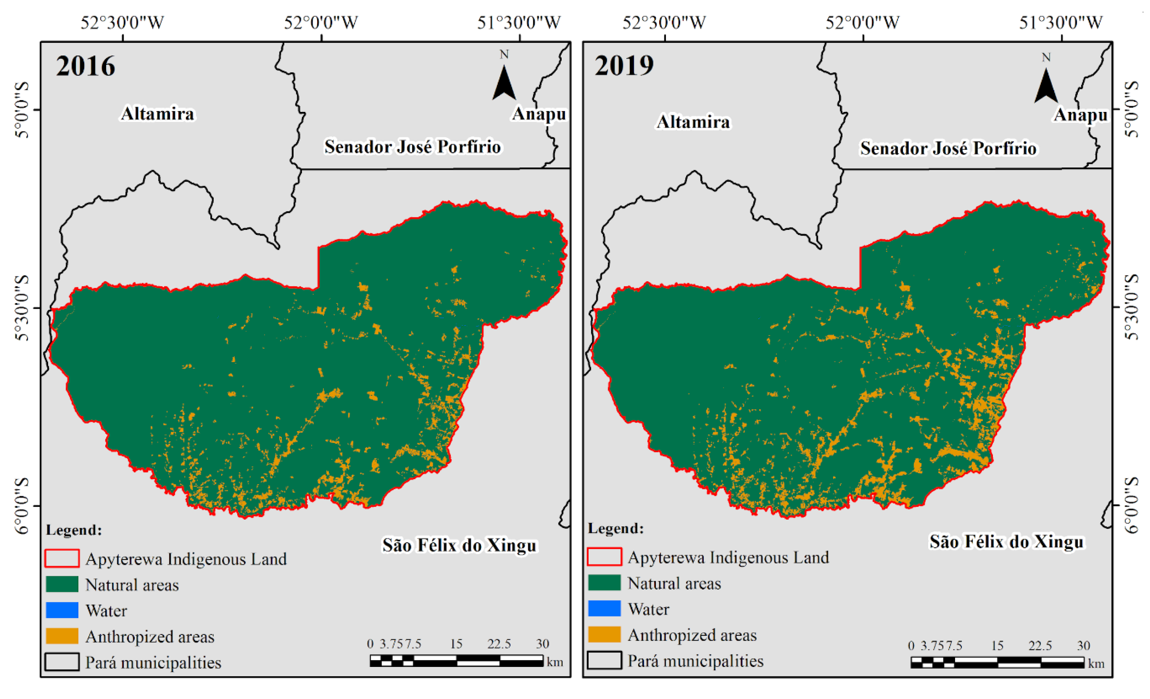
Figure 1. (a) Location of the Apyterewa Indigenous Land within the Brazilian territory, (b) Brazilian Legal Amazon, (c) municipality of São Félix do Xingu and (d) spatial location of the study area. The base map is a moderate resolution imaging spectroradiometer (MODIS) MOD09A1 product color composite R6G2B1 for the year 2019.
Forests 11 00829 g001
Figure 2. Land use and land cover maps resulting from the geographic object-based image analysis (GEOBIA) approach applied to the Apyterewa Indigenous Land in 2016 (left) and 2019 (right).
Forests 11 00829 g002
Figure 3. (a) Annual deforestation rates in the Apyterewa Indigenous Land since the initiation of anti-deforestation measures in the Brazilian Amazon estimated by the Brazilian National Institute for Space Research (INPE) [21] (orange bars represent the period spanning the LULC mappings (2016–2019)), and (b) monthly total deforestation alerts in the Apyterewa Indigenous Land estimated by INPE [21]. Although INPE [21] provides this information since 2015, the first alert detected in the study area occurred in August 2016.
Forests 11 00829 g003
Figure 4. Annual total estimated emission of particulate matter (PM)2.5 associated with fires in the Apyterewa Indigenous Land during the 2004–2019 period. Estimates were obtained using the Brazilian biomass burning emission model with fire radiative power (3BEM_FRP) model implemented in the PREP-CHEM-SRC emissions preprocessing tool version 1.8.3 [54].
Forests 11 00829 g004
Figure 5. Correlation between annual total estimated emission of PM2.5 and annual deforestation rates in the Apyterewa Indigenous Land during 2004–2016 and 2017–2019.
Forests 11 00829 g005
Figure 6. Illustration exemplifying the intrinsic relationship between fire and the deforestation process in the Apyterewa Indigenous Land on four selected dates between 2016 and 2019. The red boxes show in detail different burned areas within the indigenous land (pastures, agricultural fields and forests). These features appear dark in the satellite images. The false-color composites (R7G5B4) are just shown as illustrations and were not used for any processing for mapping land cover changes in the study area. These composites were obtained through operational land imager (OLI)/Landsat-8 images from 2 August 2016, 6 September 2017, 7 July 2018 and 27 August 2019.
Forests 11 00829 g006
Table 1. Land use and land cover classes resulting from the GEOBIA approach applied to the Apyterewa Indigenous Land in 2016 and 2019. Natural areas comprise forest and outcrop rocks and anthropized areas comprise pasture, mining, agriculture and other human activities.
Land Use and Land Cover2016 (km2)2016 (%)2019 (km2)2019 (%)
Natural Areas736595.2715492.4
Anthropized Areas3624.75707.4
Water120.1140.2

