Article

Bird Communities in Urban Riparian Areas: Response to the Local- and Landscape-Scale Environmental Variables

1
Graduate School of Frontier Science, The University of Tokyo, Kashiwa 277-8563, Japan
2
Graduate School of Horticulture, Chiba University, Matsudo 271-8510, Japan
3
Tsinghua Tongheng Urban Planning & Design Institute, Beijing 100083, China
*
Author to whom correspondence should be addressed.
Forests 2019, 10(8), 683; https://doi.org/10.3390/f10080683
Submission received: 29 June 2019 / Revised: 8 August 2019 / Accepted: 9 August 2019 / Published: 13 August 2019
(This article belongs to the Special Issue Biodiversity and Management of Temperate Floodplain Forests)

Abstract

:
Understanding how environmental changes driven by urbanization impact the biodiversity in urban riparian areas has great importance for landscape planning and river ecosystem conservation. There have been many studies on the response of bird communities to different environmental variables in urban parks; however, although supporting some of the highest bird diversities, case studies in urban riparian areas remain limited. In existing research, few studies have considered the impact of both local waterfront characteristics and surrounding environmental variables at a larger scale. In this study, we selected birds as the indicator to clarify their response to both local- and landscape-scale environmental variables in riparian areas of Tsing river, Beijing, in terms of (a) vegetation composition, (b) human disturbance, (c) land cover, and (d) landscape connectivity. We hypothesized that birds with different biological characteristics may respond differently to environmental variables. Birds were then further grouped according to the habitat type, residential type, and feeding type. It turned out that the coverage of grass and the disturbance of pedestrians are the most influential variables. Besides, compared with the land cover and landscape connectivity, the total contribution of vegetation characteristics and human disturbance accounts for the main proportion of explained variance. Information pertaining to these environmental variables can provide evidence to support bird conservation efforts in urban areas, and the identified distance threshold provides a basis for future landscape connectivity assessments.

1. Introduction

Understanding the ecological mechanisms supporting biodiversity is essential for understanding ecosystem functioning [1]. Urbanization, especially regarding megacities, has been regarded as a primary cause of habitat destruction and biodiversity loss [2,3]. On the one hand, the influx of population and the deforestation of trees in the process of urban construction leads to the destruction of natural habitats. Meanwhile, land cover changes and landscape fragmentation indirectly affect biodiversity in these habitats. On the other hand, urban green spaces, which include urban parks, croplands, and water bodies, provide important habitats for wildlife [4]. Birds are often selected as indicators because their autecology is well studied, and they are relatively easy to observe and identify [5]. As highly mobile species, birds are relatively environment-sensitive, and they are particularly responsive to environmental changes at different scales [6,7,8].
Rivers play a significant role in biogeochemical cycles and in the provision of water for domestic, agricultural, recreational, navigational, and industrial purposes [9,10]. Particularly, well-managed urban riparian areas are considered to be important habitats for birds to escape human disturbance when living in urban areas, and act as transient habitats for migratory birds [11,12,13]. There is a growing number of studies regarding biodiversity in urban green spaces, most of which have focused on urban parks [14,15,16,17,18,19,20,21]. Only a few studies have looked into bird diversity in urban riparian areas, two of them have examined how rivers and their catchments impact the functional composition of urban bird communities [10,22]. Therefore, it is necessary to clarify the sustainable mechanisms to better support its ecological functions (e.g., maintaining biodiversity).
Although a number of studies have looked into the response of birds to environmental changes, most of them have focused on a particular issue in a particular habitat, or on the influence of a particular environmental variable [23,24,25,26,27]. “Local” and “landscape” are defined as simple hierarchical classifications of environmental variables [28]. Since the 1980s, many studies have been conducted on the species–habitat relationship at a local level, that is, the responses of a single or a group of species to local habitat characteristics (e.g., number, height, and crown radius of trees) [29,30], including human disturbance represented by the traffic volume [31,32,33]. In the last decade, with the development of remote sensing technology, information on land features has become easily accessible, and studies have started to focus on the species–habitat relationship at a landscape scale, (e.g., land cover and landscape connectivity) [1,33,34]. Landscape connectivity was created to quantify connections between habitats by modeling real ecological process at the landscape scale. It is based on the theory that the viability of a species depends on the ability of individuals to access one habitat from another by crossing unsuitable habitat [35], and has been widely discussed recently [36,37,38,39]. However, few studies have assessed both local- and landscape-scale variables [1,40,41].
In addition, biological characteristics of species should be included in species-specific analyses, because the influence of environmental variables on biodiversity in a certain area also depends on biological traits of the species inhabiting that area. Since specific traits of bird species, such as habitat type, may affect the response to environmental variables, a few studies used a method to avoid the bias: they clustered species into groups according to the biological trait, and then defined a virtual species for each group [10,38]. With regard to birds, there are growing numbers of studies that simulate bird migration by setting a distance threshold, and then model biodiversity in each habitat patch [41,42,43]. It is often selected as an efficient metric for modeling ecological networks and maintaining biodiversity by using focal species, although usually empirical evidence is insufficient to verify the focal species [44,45]. However, studies considering the dispersal ability of the whole bird communities are still lacking, because information about their dispersal ability based on empirical evidence is limited in existing research [41,46].
Comprehensive studies that include the biological characteristics of multiple species and environmental variables at both the local and landscape scales are lacking, which limits their utility for biodiversity conservation. Given the limitations of existing species–habitat relationship studies, this study aimed to clarify and compare the response of bird communities to both local- and landscape-scale environmental variables. We explored environmental variables from four aspects: (a) vegetation composition, (b) human disturbance, (c) land cover, and (d) landscape connectivity. We sought to:
(1)
Clarify the avian biodiversity in urban riparian areas of the Tsing River.
(2)
Identify the influence of environmental variables on avian biodiversity.
(3)
Obtain a species-specific understanding of (2) by including biological characteristics.

2. Methods

2.1. Study Area

The Tsing River is a small urban river in the northwest of central Beijing (39°38′–41°05′ N, 115°25′–117°30′ E), China (Figure 1). It is about 23.7 km long and 100 m wide. The catchment is 375 km2 and was modeled with digital elevation model (DEM) data (resolution = 30 m) by hydrological simulation in ArcGIS. The water originates in the Western Mountains and Jade Spring Hills in the west. An important function of the Tsing River is its drainage of storm waters, but is also an important habitat for wildlife in its riparian area. The Tsing River flows along the boundary between urban and suburban areas, where the mixture of land cover has resulted from continuous urban expansion and construction over the past decade. In the upper reaches of the Tsing River, there are large green spaces and residential areas around the riparian green spaces. In the middle part, there are highly urbanized areas with residential and commercial constructions, and the riparian green spaces are maintained as urban parks to meet the recreational demand from residents. In the lower reaches, the waterfront remains relatively close to its natural condition with fewer artificial structures and lower levels of human activity and vegetation management (Figure 2).

2.2. Bird Surveys and Biodiversity Metrics

Bird surveys were conducted once a month from dawn to 10:00 and from 16:00 to dusk, between May 2016 and Apr 2017. They were carried out by professional ornithologists along 1 km randomly-allocated line transects (n = 18) [39]. Line transects (1–18) were coded from upper reach (west) to lower reach (east). Observers walked along the line transect at a speed of 1 km/h while recording birds and identified species based on a book: A field guide to the birds of China [47]. To reduce bias, birds flying over or beyond 100 m distance were not counted.
We calculated three metrics of biodiversity for each transect: (a) bird abundance (BA); (b) bird richness (BR); (c) bird diversity (BD) [48]. BA reflects the number of birds recorded along each line transect; BR reflects the number of bird species identified; and BD refers to Shannon diversity index, which reflects the evenness of species composition:
BD   =   i   =   1 S ( p i   l n   p i ) ,
where p i is a i / a i , a i is the number of the ith species, and i is one through S.

2.3. Environmental Variables and Data Collection

We selected environmental variables according to existing research [14,37,48,49]. At the local scale, we estimated 8 environmental variables: (1) ground-level: coverage of grass (%); (2) shrub-level: coverage of shrub (%); (3) tree-level: number of big trees with height > 10 m or crown > 6 m; (4) vegetation richness; (5) human disturbance: pedestrians, bicycles, motorbikes/scooters, and cars. Local-scale variables were investigated from field surveys in 54 sample sites (size: 10 × 10 m), conducted between 19 and 25 September, 2018. An example section of the Tsing River is shown in Figure 3. We selected 54 sample sites (3 sample sites on each line transect) to collect the information pertaining to vegetation structure. As to human disturbance, observers recorded the number of human disturbance items passing each sample site in 5 min during rush hour. To reduce bias, we calculated the average value of the three sites along each line transect.
At the landscape scale, we selected land cover and landscape connectivity as variables: forest (F), wooded areas (WA), grasslands (G), waterbodies (WB), water courses (WC), buildings (B), roads (R), and vacant areas (VA). Land cover classification was extracted from Gaofen-2 remote sensing imagery at a resolution of 0.8 m, which were captured on 12 September, 2015, with a solar azimuth angle of 37° and an axial inclination of 94°. Since we can measure land cover and landscape connectivity at any spatial scale, it is necessary to determine the scale at which different variables more accurately reflect biodiversity. As mentioned in [50], variables are measured in different sized area, which may lead to a “scale of effect”. To test the “scale of effect”, all landscape-scale variables were measured in two spatial areas: the observation area (with a buffer of 100 m) and the surrounding area (with a buffer of 500 m). As shown in Figure 1, we roughly interpreted the land cover of the river catchment using an object-based image analysis [51,52]. To determine the height of buildings, road hierarchy, and high-density planted woodland and low-density shrub areas, we reclassified the land covers, and verified the classification results by field surveys and Baidu Street View Map (https://map.baidu.com/) (Figure 4).
Green spaces were further extracted from the land cover classification to calculate the delta of PC (dPC) of each patch using the Conefor Sensinode 2.6 software (http://www.conefor.org/). The linkage thresholds were defined by the dispersal distance of each species. To map the landscape connectivity of a patch to a line transect, we slightly modified the existing equation of dPC [53,54] and obtained the expression of landscape connectivity of a transect ( d P C t ) as follows:
d P C t   =   i = 1 n A i A i   d P C i ,
where there are n patches overlapping with the line transect, the ith part belongs to a patch i, the area of the ith part is A i , the area of patch i is A i , and the landscape connectivity of patch i is d P C i .

2.4. Preselection of Variables and Statistical Analyses

Connections between various environmental variables are complex in the ecosystem. In the field survey, we tried to collect as much environmental variables as possible. However, those variables could be highly correlated with each other. In this case, variables with a correlation coefficient larger than 0.7 were deleted from the database, according to the result of Pearson correlation analysis (IBM SPSS Version 22, IBM Corp., Armonk, NY, USA). Besides, we tested the hypothesis that birds may respond to the height of buildings and the hierarchy of roads. The result of correlation analysis failed to support our hypothesis. We thereby merged B1, B2, B3, and R1, R2, R3 into B and R, respectively. In addition, we assigned the spatial scale of landscape variables, after examining the difference when they were measured in different spatial scales. Except forest land (F), the landscape-scale variables showed a better correlation with biodiversity indices when they were measured within a buffer of 500 m. Finally, we selected 7 local-scale variables: grass (%), shrub (%), big trees, vegetation richness, pedestrians, bicycles, motorbikes/scooters; and 6 landscape-scale variables: forest land (F), grass land (G), water (W), buildings (B), roads (R), landscape connectivity. The raw data of all environmental variables and biodiversity metrics were log-transformed, and the normality of those variables was detected using the Kolmogorov–Smirnov (K-S) test to meet the requirements of the following analyses.
The redundancy analysis (RDA), one of the multivariate statistical methods, was applied to identify the most influential variables for avian biodiversity (CANACO 5.0) [55]. The stepwise selection procedure of RDA can simplify the subset of explanatory variables (i.e., environmental variables) by a constrained ordination model. We identified the contribution of each variable to explaining the variance, and tested the significance of the contribution using a partial Monte Carlo permutation test. False discovery rate estimates, one of the significance adjustment methods, was applied to avoid Type I errors. Since the flow of the Tsing River also reflects the trend of urbanization, the spatial autocorrelation between samples was excluded by adding a covariate named “location”: the upper (transect 1–6), middle (transect 7–12), and lower (transect 13–18) reaches of the river were assigned values of 1, 2, and 3 respectively. We conducted partial RDA on all birds and the top 10 birds. To further discuss the response of birds with different biological characteristics, we grouped them based on the habitat type, residence type, and foraging guilds: forest bird (inhabiting forest or wooded areas), water bird, resident bird, migratory bird, carnivorous bird, omnivorous bird. Then we repeated the RDA on the six groups respectively. Table S1 contains all information on biological characteristics, collected from [47].

3. Results

3.1. Observed Birds and the Selected Variables

A total of 85 bird species and 15,632 individual birds were observed along Tsing River, as shown in the species list (Table S1). Among all species (n = 85), forest birds and water birds occupied 31.8% and 18.9%, respectively; resident birds occupied 29.4%, the rest were regarded as migratory birds; carnivorous birds and omnivorous birds occupied 40% and 57.6%, respectively.

3.2. Overall Responses of Birds

Table 1 shows the result of RDA, with an acceptable significance calculated by the permutation test (p = 0.022). The overall influential variables for all birds and the corresponding explained variance are grass (48.5%), pedestrians (11.7%), bicycles (10%), F (5.5%). In comparison, the top 10 birds have more diverse responses: F (22.7%), coverage of grass (18.2%), coverage of shrub (11.3%), bicycles (8%), vegetation richness (6.2%), motorbikes (7.3%).
Figure 5 illustrates the correlation between all response variables and explanatory variables, from which we can get more details of a single biodiversity metric. Figure 5a shows that BA and BR are more related to the coverage of grass (explained variance = 48.5%, p = 0.034), compared with BD. for the top 10 birds, Figure 5b suggests that the coverage of grass has a significant correlation with the abundance of Cyanopica cyana (CyanCyan) and Pycnonotus sinensis (PycnSine), although it is the second important variable for the top 10 birds (explained variance = 18.2%, p = 0.054); the most influential variable F (explained variance = 22.5%, p = 0.034) has a more significant correlation with Anas platyrhynchos (AnasPlat) than other species among the top 10 birds.

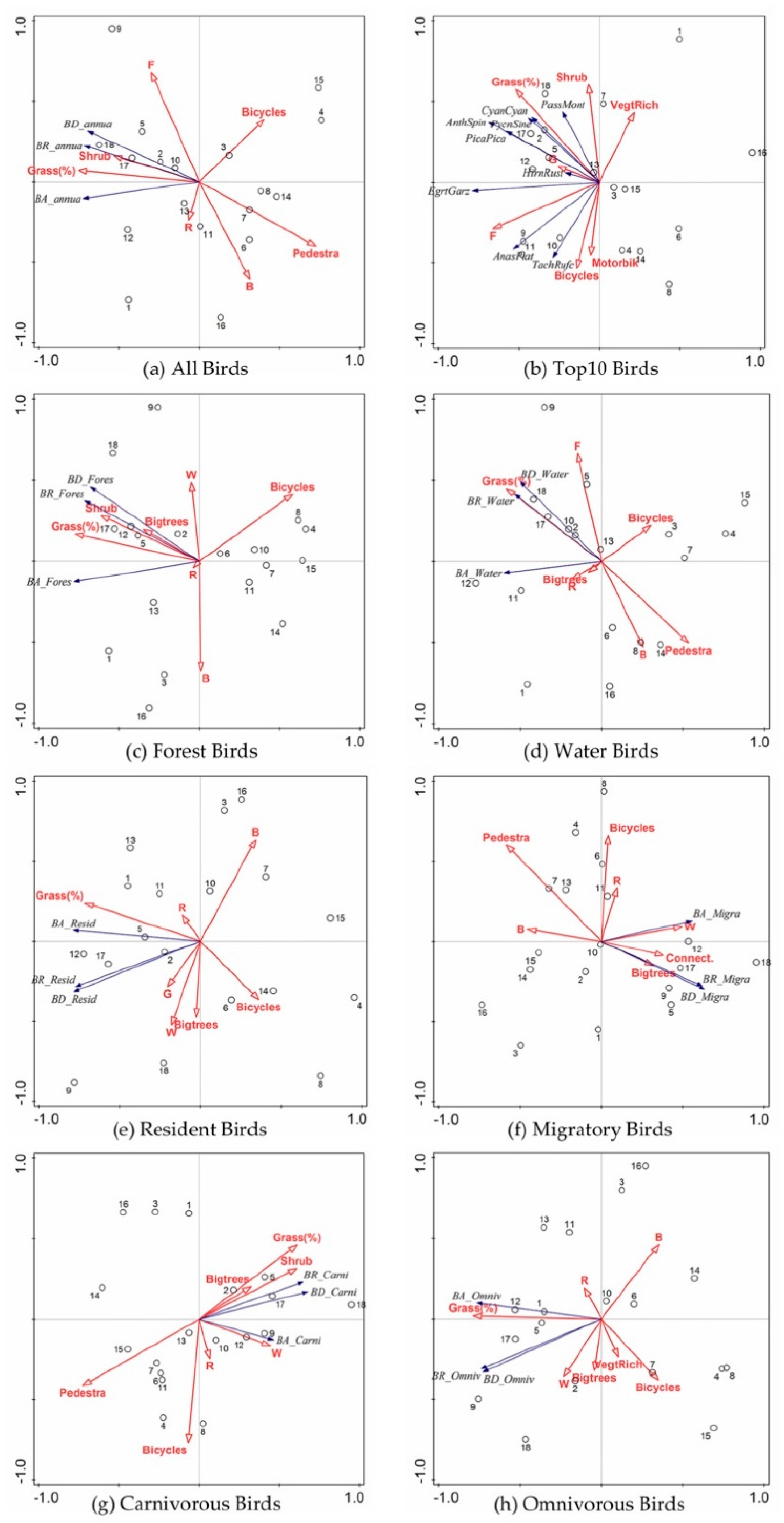
3.3. Species Specific Responses of Birds

Similar as the RDA for all birds and top 10 birds, with regard to each bird group, Table 1 shows the importance ordination of environmental variables and the contribution of explained variance of each single variable. The coverage of grass is the crucial variable for resident birds (45.4%), forest birds (49.1%), water birds (26.9%), and omnivorous birds (54.1%). Meanwhile, the number of pedestrians passing ranks top for migratory birds (30.7%) and carnivorous birds (39.7%). Among all variables, the coverage of grass and the disturbance of pedestrians can be the most influential variables affecting the avian biodiversity.
Specifically, for resident birds and migratory birds, although both of them are negatively correlated with human disturbance, migratory birds (explained variance of pedestrians = 30.7%, p = 0.034) are more sensitive than resident birds (explained variance of bicycles = 13.9%, p = 0.038).

4. Discussion

4.1. The Scale of Effect of Landscape-Scale Variables

As for the scale of effect, our findings agree with those of [56] that the spatial scale at which species respond to environmental changes should be clarified case by case. For example, planting a tree in a household garden and restoring a river may both affect biodiversity, but their influence cannot easily be compared for specific species. In the present study, the landscape connectivity metric reflected a more significant correlation to bird diversity when measured in the surrounding area, the larger scale. Our finding was coincident with [37], they quantified landscape connectivity at three spatial scales (3, 6, and 12 km), and found that connectivity variables are more strongly correlated with the composition of bird communities at larger spatial scales. However, with regard to F (forest land), it reflected biodiversity more accurately than the other land-cover types when measured in the observation area, with a buffer of 100 m.

4.2. What Can Be Concluded from the Responses of Migratory Birds?

As shown in Table 1, the responses of migratory birds are slightly different to others, but quite informative. For birds who need to migrate, what factors are most attractive for them? Most of the birds we observed along the Tsing River are summer migrants, which means they fly for a long time, trying to find a warm place to build nests and breed their next generation. Therefore, it is not difficult to understand why the area of water and the number of big trees present an effect on biodiversity of migratory birds. Basically, migratory birds need to find water sources and food for living; second, big trees are usually regarded as a safe place to build a nest.
Moreover, the migratory bird is the only group that responded to landscape connectivity (10.7%, p = 0.044). According to the island biogeography, connections between habitat patches can contribute to the exchange of gene flow among habitats, and thereby promote the biodiversity. In comparison, for resident birds, the optimal preference is places with more grass land (45.4%, p = 0.034) and less built-up (11.2%, p = 0.02), where they can find some insects and seeds of plants for food.

4.3. The Dispersal Distance of Birds and Landscape Connectivity

Landscape connectivity is a metric to simulate the connection between habitats in the eye of species. In the existing research, several studies assessed landscape connectivity for multiple species by defining species groups and selecting focal species or virtual species for each group [38,43,57,58,59]. However, seldom studies have included dispersal distances of birds in landscape connectivity assessment. In this case, we proposed an approach of defining the distance threshold of landscape connectivity.
First, the dispersal distance of each bird species should be identified. Two studies [38,43] modeled the dispersal distance of birds by the taxonomy, with which the dispersal distance can be calculated based on foraging guild and body mass M (in kg); the equation used to calculate this was: pM0.63 (p = 13.1). However, when we verified this equation using observed dispersal distance data collected from the literature, it failed to predict the dispersal distance. We proposed a method synthesizing the result from the literature regarding the dispersal distance of birds and optimized the existing calculation formula. (1) Group all birds according to their family; (2) calculate the parameter p of each family according to the observed data from the literature; (3) figure the dispersal distances of the rest species in the family using the parameter p calculated in the last step. The complete results of dispersal distance and references are shown in Table S2.
Second, to determine the optimal threshold of landscape connectivity, when landscape connectivity can best represent the actual bird diversity, we group birds based on their dispersal distance: 0–1, 0–2, 0–3, 0–4, 0–5 km. Accordingly, we set different distance thresholds of landscape connectivity (1, 2, 3, 4, 5 km) for scenario analysis, and compare the correlation between landscape connectivity and biodiversity of birds (Table S3). The most significantly correlated scenario implies that the dPC metric can better simulate the real dispersal distance of species under the setting of that threshold. Finally, “5 km” is selected as an optimal setting of the threshold. This approach is repeatable, applicable, and could be useful for determining the linkage threshold in the assessment of landscape connectivity and guide city planners in the conservation of multiple species.

4.4. Significant Variables and Implication for Bird Conservation

Avian biodiversity is affected by combinations of environmental factors [37]. We discussed the impact of environmental variables on bird communities in urban riparian areas, our findings provide evidence for bird conservation in urban riparian areas.
If we compare the explanation of local variables and landscape variables, it is obvious that the sum of explanation of local-variables is greater than that of landscape-scale variables. As we know, avian biodiversity is affected by multi-scale variables. However, in general, the vegetation characteristics and human disturbance in local habitat tend to be more important than surrounding land cover.
For vegetation characteristics, the coverage of grass on the ground had the most significant, positive influence on birds. It may due to the proportion of birds feeding on the grassland, which is much higher than that of other foraging zones. Besides, the positive influence of large trees and the coverage of shrubs on birds agrees with the results of [14].
With regard to human disturbance, in riparian areas of Tsing River, bird communities were more sensitive to the number pedestrians and bicycles than that of motorbikes and cars. [60] found that bicycles have more negative effects on birds than pedestrians in parks. Surprisingly, the top 10 birds responded less significantly to the disturbance of pedestrians than the whole bird communities, which may be due to the adaptation of common birds to the urbanized environment with human disturbance.
At the landscape scale, among all land-cover types, the area of forest and water, playing as a green surrounding environment in an urbanized area, affect the biodiversity of birds positively. Conversely, the area of buildings and roads had a negative influence. It is undeniable that urbanization damages biodiversity [14,39].
During riverbank maintenance, improving grassland coverage can not only prevent soil erosion, but also provide food (plant seeds and insects) for birds; planting more large trees is also an important strategy that can offer a wider range of options for nesting birds. In addition, increasing green spaces and reducing pavement and building density near riparian areas are efficient strategies, providing a greener environment for bird communities, which agrees with [61] that increasing green spaces has positive influences on bird diversity in Beijing. Future research could not only include birds but also insects, reptiles, and mammals with relevant empirical evidence of their dispersal distance. A long-term species survey is also needed, regarding that the responses of birds to environmental changes in landscape scale may be hysteretic [62].

5. Conclusions

This study assessed the responses of bird species to the local- and landscape-scale variables in riparian areas of Tsing River, which flows through urban and suburban areas of Beijing. Among all environmental variables, we found that the coverage of grass has the most positive effect on biodiversity of birds, while the number of bicycles and pedestrians have the most negative effect on biodiversity of birds. In general, local-scale variables are more influential for avian biodiversity than landscape-scale variables.
In addition, our findings agree with the previous studies that the biological traits of birds should be considered in discussions of the species–habitat relationship; the fine scale of an environmental variable should be clarified case by case. The optimal distance threshold of landscape connectivity was identified as 5 km, according to the dispersal distance of birds in the study area. Our findings provide new data for bird conservation in riparian areas of cities, which can be applied to vegetation management and landscape planning for biodiversity conservation.

Supplementary Materials

The following are available online at https://www.mdpi.com/1999-4907/10/8/683/s1, Table S1: Species list, Table S2: Dispersal distances (DD) of species, Table S3: Correlation between landscape connectivity and biodiversity in different seasons.

Author Contributions

Conceptualization, S.G., K.S. and T.T.; data curation, S.G.; formal analysis, S.G. and C.S.; investigation, S.G., C.S. and J.C.; methodology, S.G.; resources, J.C.; supervision, K.S.; validation, C.S.; visualization, S.G. and C.S.; writing—original draft, S.G.; writing—review and editing, S.G.

Funding

This research received no external funding.

Acknowledgments

The Gaofen-2 remote sensing image was supported by Urban Spatial Information Engineering Laboratory of Beijing Forestry University. We thank the Department of Ecology and Environment, Beijing Tsinghua Tongheng Urban Planning and Design Institute for helping with professional knowledge of ecology and bird surveys.

Conflicts of Interest

The authors declare no conflict of interest.

References

  1. Humphrey, J.W.; Watts, K.; Fuentes-Montemayor, E.; Macgregor, N.A.; Peace, A.J.; Park, K.J. What can studies of woodland fragmentation and creation tell us about ecological networks? A literature review and synthesis. Landsc. Ecol. 2015, 30, 21–50. [Google Scholar] [CrossRef]
  2. Ortega-Álvarez, R.; MacGregor-Fors, I. Living in the big city: Effects of urban land-use on bird community structure, diversity, and composition. Landsc. Urban Plan. 2009, 90, 189–195. [Google Scholar] [CrossRef]
  3. Haedo, J.; Gioia, A.; Aráoz, E.; Paolini, L.; Malizia, A. Primary productivity in cities and their influence over subtropical bird assemblages. Urban For. Urban Green. 2017, 26, 57–64. [Google Scholar] [CrossRef]
  4. Jokimäki, J.; Suhonen, J.; Kaisanlahti-Jokimäki, M.L.; Jukka, S.; Marja-Liisa, K.J. Urban core areas are important for species conservation: A European-level analysis of breeding bird species. Landsc. Urban Plan. 2018, 178, 73–81. [Google Scholar] [CrossRef]
  5. Liang, J.; Xing, W.; Zeng, G.; Li, X.; Peng, Y.; Li, X.; Gao, X.; He, X. Where will threatened migratory birds go under climate change? Implications for China’s national nature reserves. Sci. Total Environ. 2018, 645, 1040–1047. [Google Scholar] [CrossRef] [PubMed]
  6. Cunningham, R.; Lindenmayer, D.; Barton, P.; Ikin, K.; Crane, M.; Michael, D.; Okada, S.; Gibbons, P.; Stein, J. Cross-sectional and temporal relationships between bird occupancy and vegetation cover at multiple spatial scales. Ecol. Appl. 2014, 24, 1275–1288. [Google Scholar] [CrossRef] [PubMed] [Green Version]
  7. Burgess, E.E.; Maron, M. Does the response of bird assemblages to fire mosaic properties vary among spatial scales and foraging guilds? Landsc. Ecol. 2016, 31, 687–699. [Google Scholar] [CrossRef]
  8. Guttery, M.R.; Ribic, C.A.; Sample, D.W.; Paulios, A.; Trosen, C.; Dadisman, J.; Horton, J.A. Scale-specific habitat relationships influence patch occupancy: Defining neighborhoods to optimize the effectiveness of landscape-scale grassland bird conservation. Landsc. Ecol. 2017, 32, 515–529. [Google Scholar] [CrossRef]
  9. Mu, R.; Kumaraswamy, K.; Mohanraj, R. Environmental Management of River Basin Ecosystems; Springer: Berlin/Heidelberg, Germany, 2015. [Google Scholar]
  10. Suri, J.; Anderson, P.M.; Charles-Dominique, T.; Hellard, E.; Cumming, G.S. More than just a corridor: A suburban river catchment enhances bird functional diversity. Landsc. Urban Plan. 2017, 157, 331–342. [Google Scholar] [CrossRef]
  11. Pennington, D.N.; Hansel, J.; Blair, R.B. The conservation value of urban riparian areas for landbirds during spring migration: Land cover, scale, and vegetation effects. Biol. Conserv. 2008, 141, 1235–1248. [Google Scholar] [CrossRef]
  12. Tiwary, N.; Urfi, A. Spatial variations of bird occupancy in Delhi: The significance of woodland habitat patches in urban centres. Urban For. Urban Green. 2016, 20, 338–347. [Google Scholar] [CrossRef]
  13. Threlfall, C.G.; Williams, N.S.; Hahs, A.K.; Livesley, S.J. Approaches to urban vegetation management and the impacts on urban bird and bat assemblages. Landsc. Urban Plan. 2016, 153, 28–39. [Google Scholar] [CrossRef]
  14. Huang, Y.; Zhao, Y.; Li, S.; Von Gadow, K. The Effects of habitat area, vegetation structure and insect richness on breeding bird populations in Beijing urban parks. Urban For. Urban Green. 2015, 14, 1027–1039. [Google Scholar] [CrossRef]
  15. Yang, G.; Xu, J.; Wang, Y.; Wang, X.; Pei, E.; Yuan, X.; Li, H.; Ding, Y.; Wang, Z. Evaluation of microhabitats for wild birds in a Shanghai urban area park. Urban For. Urban Green. 2015, 14, 246–254. [Google Scholar] [CrossRef]
  16. Sasaki, T.; Imanishi, J.; Fukui, W.; Morimoto, Y. Fine-scale characterization of bird habitat using airborne LiDAR in an urban park in Japan. Urban For. Urban Green. 2016, 17, 16–22. [Google Scholar] [CrossRef]
  17. Estevo, C.A.; Nagy-Reis, M.B.; Silva, W.R. Urban parks can maintain minimal resilience for Neotropical bird communities. Urban For. Urban Green. 2017, 27, 84–89. [Google Scholar] [CrossRef]
  18. Morelli, F.; Benedetti, Y.; Su, T.; Zhou, B.; Moravec, D.; Šímová, P.; Liang, W. Taxonomic diversity, functional diversity and evolutionary uniqueness in bird communities of Beijing’s urban parks: Effects of land use and vegetation structure. Urban For. Urban Green. 2017, 23, 84–92. [Google Scholar] [CrossRef]
  19. Steel, Z.L.; Steel, A.E.; Williams, J.N.; Viers, J.H.; Marquet, P.A.; Barbosa, O. Patterns of bird diversity and habitat use in mixed vineyard-matorral landscapes of Central Chile. Ecol. Indic. 2017, 73, 345–357. [Google Scholar] [CrossRef]
  20. Morelli, F. High nature value farmland increases taxonomic diversity, functional richness and evolutionary uniqueness of bird communities. Ecol. Indic. 2018, 90, 540–546. [Google Scholar] [CrossRef]
  21. Canedoli, C.; Manenti, R.; Padoa-Schioppa, E. Birds biodiversity in urban and periurban forests: Environmental determinants at local and landscape scales. Urban Ecosyst. 2018, 21, 779–793. [Google Scholar] [CrossRef]
  22. Banville, M.J.; Bateman, H.L.; Earl, S.R.; Warren, P.S. Decadal declines in bird abundance and diversity in urban riparian zones. Landsc. Urban Plan. 2017, 159, 48–61. [Google Scholar] [CrossRef] [Green Version]
  23. Barton, P.S.; Ikin, K.; Smith, A.L.; MacGregor, C.; Lindenmayer, D.B. Vegetation structure moderates the effect of fire on bird assemblages in a heterogeneous landscape. Landsc. Ecol. 2014, 29, 703–714. [Google Scholar] [CrossRef]
  24. Mammides, C.; Kadis, C.; Coulson, T. The effects of road networks and habitat heterogeneity on the species richness of birds in Natura 2000 sites in Cyprus. Landsc. Ecol. 2015, 30, 67–75. [Google Scholar] [CrossRef]
  25. Chambers, C.L.; Cushman, S.A.; Medina-Fitoria, A.; Martínez-Fonseca, J.; Chávez-Velásquez, M. Influences of scale on bat habitat relationships in a forested landscape in Nicaragua. Landsc. Ecol. 2016, 31, 1299–1318. [Google Scholar] [CrossRef]
  26. Fartmann, T.; Kämpfer, S.; Brüggeshemke, J.; Juchem, M.; Klauer, F.; Weking, S.; Löffler, F. Landscape-scale effects of Christmas-tree plantations in an intensively used low-mountain landscape–Applying breeding bird assemblages as indicators. Ecol. Indic. 2018, 94, 409–419. [Google Scholar] [CrossRef]
  27. Salgueiro, P.A.; Mira, A.; Rabaça, J.E.; Santos, S.M. Identifying critical thresholds to guide management practices in agro-ecosystems: Insights from bird community response to an open grassland-to-forest gradient. Ecol. Indic. 2018, 88, 205–213. [Google Scholar] [CrossRef] [Green Version]
  28. Galitsky, C.; Lawler, J.J. Relative influence of local and landscape factors on bird communities vary by species and functional group. Landsc. Ecol. 2015, 30, 287–299. [Google Scholar] [CrossRef]
  29. Taylor, J.J.; Lepczyk, C.A.; Brown, D.G. Patch and matrix level influences on forest birds at the rural–urban interface. Landsc. Ecol. 2016, 31, 1005–1020. [Google Scholar] [CrossRef]
  30. O’Neill, R.V.; Deangelis, D.L.; Waide, J.B.; Allen, T.F.; Allen, G.E. A Hierarchical Concept of Ecosystems (No. 23); Princeton University Press: Princeton, NJ, USA, 1986. [Google Scholar]
  31. Rukke, B.A.; Midtgaard, F. The importance of scale and spatial variables for the fungivorous beetle Bolitophagus reticulatus (Coleoptera, Tenebrionidae) in a fragmented forest landscape. Ecography 1998, 21, 561–572. [Google Scholar] [CrossRef]
  32. Dorresteijn, I.; Teixeira, L.; Von Wehrden, H.; Loos, J.; Hanspach, J.; Stein, J.A.R.; Fischer, J. Impact of land cover homogenization on the Corncrake (Crex crex) in traditional farmland. Landsc. Ecol. 2015, 30, 1483–1495. [Google Scholar] [CrossRef]
  33. Reijnen, R.; Foppen, R.; Ter Braak, C.; Thissen, J. The Effects of Car Traffic on Breeding Bird Populations in Woodland. III. Reduction of Density in Relation to the Proximity of Main Roads. J. Appl. Ecol. 1995, 32, 187. [Google Scholar] [CrossRef]
  34. Forman, R.T.T.; Reineking, B.; Hersperger, A.M. Road Traffic and Nearby Grassland Bird Patterns in a Suburbanizing Landscape. Environ. Manag. 2002, 29, 782–800. [Google Scholar] [CrossRef]
  35. Uuemaa, E.; Mander, U.; Marja, R. Trends in the use of landscape spatial metrics as landscape indicators: A review. Ecol. Indic. 2013, 28, 100–106. [Google Scholar] [CrossRef]
  36. Vihervaara, P.; Mononen, L.; Auvinen, A.P.; Virkkala, R.; Lü, Y.; Pippuri, I.; Valkama, J. How to integrate remotely sensed data and biodiversity for ecosystem assessments at landscape scale. Landsc. Ecol. 2015, 30, 501–516. [Google Scholar] [CrossRef]
  37. Tannier, C.; Foltête, J.C.; Girardet, X. Assessing the capacity of different urban forms to preserve the connectivity of ecological habitats. Landsc. Urban Plan. 2012, 105, 128–139. [Google Scholar] [CrossRef]
  38. Foltête, J.C.; Clauzel, C.; Vuidel, G. A software tool dedicated to the modelling of landscape networks. Environ. Model. Softw. 2012, 38, 316–327. [Google Scholar] [CrossRef]
  39. Buelow, C.A.; Baker, R.; Reside, A.E.; Sheaves, M. Spatial dynamics of coastal forest bird assemblages: The influence of landscape context, forest type, and structural connectivity. Landsc. Ecol. 2017, 32, 547–561. [Google Scholar] [CrossRef]
  40. Sahraoui, Y.; Foltête, J.C.; Clauzel, C. A multi-species approach for assessing the impact of land-cover changes on landscape connectivity. Landsc. Ecol. 2017, 32, 1819–1835. [Google Scholar] [CrossRef]
  41. Xu, X.; Xie, Y.; Qi, K.; Luo, Z.; Wang, X. Detecting the response of bird communities and biodiversity to habitat loss and fragmentation due to urbanization. Sci. Total Environ. 2018, 624, 1561–1576. [Google Scholar] [CrossRef]
  42. Forman, R.T.; Collinge, S.K. Nature conserved in changing landscapes with and without spatial planning. Landsc. Urban Plan. 1997, 37, 129–135. [Google Scholar] [CrossRef]
  43. Mimet, A.; Clauzel, C.; Foltête, J.C. Locating wildlife crossings for multispecies connectivity across linear infrastructures. Landsc. Ecol. 2016, 31, 1955–1973. [Google Scholar] [CrossRef]
  44. Lambeck, R.J. Focal Species: A Multi-Species Umbrella for Nature Conservation. Especies Focales: Una Sombrilla Multiespecifica para Conservar la Naturaleza. Conserv. Biol. 1997, 11, 849–856. [Google Scholar] [CrossRef] [Green Version]
  45. Silvano, A.L.; Guyer, C.; Steury, T.D.; Grand, J.B. Selecting focal species as surrogates for imperiled species using relative sensitivities derived from occupancy analysis. Ecol. Indic. 2017, 73, 302–311. [Google Scholar] [CrossRef]
  46. Loman, Z.G.; Deluca, W.V.; Harrison, D.J.; Loftin, C.S.; Rolek, B.W.; Wood, P.B. Landscape capability models as a tool to predict fine-scale forest bird occupancy and abundance. Landsc. Ecol. 2018, 33, 77–91. [Google Scholar] [CrossRef]
  47. Miguet, P.; Jackson, H.B.; Jackson, N.D.; Martin, A.E.; Fahrig, L. What determines the spatial extent of landscape effects on species? Landsc. Ecol. 2016, 31, 1177–1194. [Google Scholar] [CrossRef]
  48. MacKinnon, J.R.; MacKinnon, J.; Phillipps, K.; He, F.Q. A Field Guide to the Birds of China; Oxford University Press: Oxford, UK, 2000. [Google Scholar]
  49. Shih, W.Y. Bird diversity of greenspaces in the densely developed city centre of Taipei. Urban Ecosyst. 2018, 21, 379–393. [Google Scholar] [CrossRef]
  50. Alexandrino, E.R.; Buechley, E.R.; Piratelli, A.J.; de Barros Ferraz, K.M.P.M.; Moral, R.D.A.; Şekercioğlu, Ç.H.; Silva, W.R.; do Couto, H.T.Z. Bird sensitivity to disturbance as an indicator of forest patch conditions: An issue in environmental assessments. Ecol. Indic. 2016, 66, 369–381. [Google Scholar] [CrossRef] [Green Version]
  51. Kettig, R.; Landgrebe, D. Classification of Multispectral Image Data by Extraction and Classification of Homogeneous Objects. IEEE Trans. Geosci. Electron. 1976, 14, 19–26. [Google Scholar] [CrossRef] [Green Version]
  52. Vieira, M.A.; Formaggio, A.R.; Rennó, C.D.; Atzberger, C.; Aguiar, D.A.; Mello, M.P. Object Based Image Analysis and Data Mining applied to a remotely sensed Landsat time-series to map sugarcane over large areas. Remote Sens. Environ. 2012, 123, 553–562. [Google Scholar] [CrossRef]
  53. Saura, S.; Pascual-Hortal, L. A new habitat availability index to integrate connectivity in landscape conservation planning: Comparison with existing indices and application to a case study. Landsc. Urban Plan. 2007, 83, 91–103. [Google Scholar] [CrossRef]
  54. Saura, S.; Torné, J. Conefor Sensinode 2.2: A software package for quantifying the importance of habitat patches for landscape connectivity. Environ. Model. Softw. 2009, 24, 135–139. [Google Scholar] [CrossRef]
  55. Lepš, J.; Šmilauer, P. Multivariate Analysis of Ecological Data Using CANOCO; Cambridge University Press: Cambridge, UK, 2003. [Google Scholar]
  56. Grafius, D.R.; Corstanje, R.; Siriwardena, G.M.; Plummer, K.E.; Harris, J.A. A bird’s eye view: Using circuit theory to study urban landscape connectivity for birds. Landsc. Ecol. 2017, 32, 1771–1787. [Google Scholar] [CrossRef]
  57. Moudrý, V.; Komárek, J.; Šímová, P. Which breeding bird categories should we use in models of species distribution? Ecol. Indic. 2017, 74, 526–529. [Google Scholar] [CrossRef]
  58. Hostetler, M. Scale, birds, and human decisions: A potential for integrative research in urban ecosystems. Landsc. Urban Plan. 1999, 45, 15–19. [Google Scholar] [CrossRef]
  59. Bernard, G.E.; Van Dongen, W.F.; Guay, P.J.; Symonds, M.R.; Robinson, R.W.; Weston, M.A. Bicycles evoke longer flight-initiation distances and higher intensity escape behaviour of some birds in parks compared with pedestrians. Landsc. Urban Plan. 2018, 178, 276–280. [Google Scholar] [CrossRef]
  60. Guo, S.; Saito, K.; Yin, W.; Su, C. Landscape Connectivity as a Tool in Green Space Evaluation and Optimization of the Haidan District, Beijing. Sustainability 2018, 10, 1979. [Google Scholar] [CrossRef]
  61. Pei, N.; Wang, C.; Jin, J.; Jia, B.; Chen, B.; Qie, G.; Qiu, E.; Gu, L.; Sun, R.; Li, J.; et al. Long-term afforestation efforts increase bird species diversity in Beijing, China. Urban For. Urban Green. 2018, 29, 88–95. [Google Scholar] [CrossRef]
  62. Groffman, P.M.; Baron, J.S.; Blett, T.; Gold, A.J.; Goodman, I.; Gunderson, L.H.; Levinson, B.M.; Palmer, M.A.; Paerl, H.W.; Peterson, G.D.; et al. Ecological Thresholds: The Key to Successful Environmental Management or an Important Concept with No Practical Application? Ecosystems 2006, 9, 1–13. [Google Scholar] [CrossRef]
Figure 1. The location and the catchment of the Tsing River. Land covers were interpreted from Gaofen-2 remote sensing image.
Forests 10 00683 g001
Figure 2. Images of the Tsing River and waterfronts: (a) in the upper reaches, although there are walkways along the river, there is little human activity and some sections are inaccessible; (b) in the middle reaches, recreational functions are taken into account in plant allocation and landscape design because of the large number of residential and commercial areas around it; (c) in the lower reaches, human activities and vegetation management are less frequent, and there are dense trees on both sides of natural riverbanks.
Forests 10 00683 g002
Figure 3. Illustration of the river section. Local environmental variables were investigated from field surveys in 54 sample sites (size: 10 × 10 m).
Forests 10 00683 g003
Figure 4. An example of land cover interpretation. Objective-based image analysis can classify forest, wooded areas, grassland, water, cropland, road, building, and vacant area. The reclassification of building and road were based on field surveys and Baidu Street View Map (https://map.baidu.com/).
Forests 10 00683 g004
Figure 5. Redundancy analysis tri-plots showing correlation between environmental variables and avian biodiversity, including: (a) all birds; (b) the top 10 birds; (c) forest birds; (d) water birds; (e) resident birds; (f) migratory birds; (g)carnivorous birds; (h) omnivorous birds. Seven local-scale variables and six landscape-scale variables were involved in the analysis: Grass = the coverage of grass; Shrub = the coverage of shrub; VegtRich = the vegetation richness; Bigtrees = the number of big trees; Pedestra = the number of pedestrians; Bicycles = the number of bicycles; Motorbik = the number of motorbikes; F = forest land; W = water area; G = grassland; B = building; R = road; Connect. = landscape connectivity. Three biodiversity indices: BA = bird abundance; BR = bird richness; BD = bird diversity. The top 10 birds: Passer montanus (PassMont), Anas platyrhynchos (AnasPlat), Cyanopica cyana (CyanCyan), Pica pica (PicaPica), Tachybaptus ruficollis (TachRufc), Hirundo rustica (HirnRust), Corvus dauuricus (CorvDauu), Anthus spinoletta (AnthSpin), Pycnonotus sinensis (PycnSine), Egretta garzetta (EgrtGarz).
Forests 10 00683 g005
Table 1. Redundancy analysis with biodiversity metrics and influential environmental variables.
NameExplains %Pseudo-Fp
All birdsGrass (%)48.514.10.034
Pedestrians11.74.10.074
Bicycles10.06.20.098
F5.54.60.080
Top 10 birdsF22.74.40.034
Grass (%)18.24.30.054
Shrub11.33.10.022
Bicycles8.02.40.038
Veg. Richness6.22.00.066
Motorbikes/scooters7.32.80.052
Resident birdsGrass (%)45.412.50.034
Bicycles13.97.90.038
B11.23.60.020
W6.65.00.052
Migratory birdsPedestrians30.76.70.034
W18.35.00.064
Connect.5km10.74.40.044
Big trees8.35.50.070
Bicycles3.12.30.074
Forest birdsGrass (%)49.114.50.034
Bicycles12.94.80.020
Shrub9.64.40.052
R4.52.50.082
B6.85.40.052
Water birdsGrass (%)26.95.50.078
F6.12.10.068
Pedestrians9.84.70.074
Carnivorous birdsPedestrians39.79.90.034
Bicycles6.22.50.096
Omnivorous birdsGrass (%)54.117.70.034
B11.44.60.050
Bicycles9.96.90.038
Note: F = forest land, G = grass land, W = water, B = buildings, R = roads, Connect.5km = landscape connectivity with a distance threshold of 5 km.

