Article

Environmental Vulnerability in Pre-Salt Oil and Gas Operations †

by
Tatiana Farane Mein
1,*,
André Luiz Veiga Gimenes
2,
Eduardo Mario Dias
1,
Maria Lídia Rebello Pinho Dias Scoton
1 and
Miguel Edgar Morales Udaeta
2,*
1
Grupo de Automação Elétrica de Sistemas Industriais (GAESI), 05508-010 São Paulo, Brazil
2
Energy Group of the Department of Energy and Electrical Automation Engineering, GEPEA/EPUSP, 05508-010 São Paulo, Brazil
*
Authors to whom correspondence should be addressed.
This paper is an extended version of our paper published in 2020 The First World Energies Forum (WEF-1) Conference, online, 15 September–5 October 2020; Proceedings 2020, 58, 30.
Energies 2021, 14(3), 732; https://doi.org/10.3390/en14030732
Submission received: 9 December 2020 / Revised: 11 January 2021 / Accepted: 26 January 2021 / Published: 30 January 2021
(This article belongs to the Special Issue Selected Papers from The First World Energies Forum (WEF-1))

Abstract

:
The objective of this work is to analyze disturbances in the environment caused by anthropic activities in the oil and gas extraction sector. Methodologically, focusing on environmental vulnerability (EV), hydrocarbons (oil and gas) are considered through a qualitative and quantitative analysis of environmental impacts, including the research of Environmental Impact Studies and procedures like EIA/RIMA (institutional Environmental Impact Reports in Brazil). This study focuses on the operation and demobilization of the offshore drilling activity and the installation and operation of the Santos Basin pre-salt oil and gas production (Stages 1, 2, and 3). The criteria addressed in the EIA/RIMAs are used, focusing on those that correlate with EV and oil and gas extraction. Impacts for long-term, permanent, partially reversible, or irreversible disturbances are filtered, totaling 53 impacts (31 effective/21 potential). We concluded that the criteria and methodologies of EIAs vary between stages. At times, the variation is so drastic that the same impact can have a completely different rating from one stage to another, despite referring to the same area. This condition makes it impossible to define a single vulnerability index for the pre-salt venture. This work does not offer a concrete resolution, but exposes the EV issue and its inconsistencies.

1. Introduction

Fossil resources, such as oil and natural gas (NG), are non-renewable, as their formation is on a millennial scale. Hydrocarbons (HC) damage the planet from the moment of its invasive extraction (that has a risk of spillage) until its use (through the release of greenhouse gases (GHG), for example) [1,2,3,4].
Brazil began the pre-salt oil and natural gas offshore exploration in the early 1960s, increasing exponentially the domestic oil and natural gas production. The main pre-salt reserve is in the state of São Paulo (approximately 55 to 300 km from its coast). The Geographic Area of the Santos Basin (AGBS, Área Geográfica Bacia de Santos) has an area of 40,663 km2 and is at a depth of 100 to 3000 m. In 2006, the Brazilian oil company, Petrobras, continued its exploration in order to discover new oil and gas fields, as it hoped to increase its national production: a goal that it successfully achieved. That same year, Petrobras estimated that it would drill 62 wells of the pre-salt reservoirs—25 exploratory and 27 development sites—from 2008 to 2010. In order to drill these wells, Petrobras proposed to use nine floating rigs—five drill ships and four semi-submersible platforms [5].
Various geological and geophysical methods are used in order to indicate the most suitable location for drilling. The drilling rigs can be transported by tugboats or self-propelled to the drilling site, where they remain positioned at the coordinates of the well throughout the drilling process. The marine drilling unit can be positioned using a dynamic positioning system or a conventional anchoring system (anchors and mooring lines). In the dynamic positioning system, there is no physical connection between the platform and the seabed, except for the drilling equipment. In the conventional anchoring system, the positioning of the rig is held by several anchors arranged radially around the location, individually attached to the platform by several anchoring lines (ranging from moorings to steel cables and polyester cables). Torpedo type anchors (which are driven into the seabed) and conventional anchors (such as the Stevin) are used to anchor drilling rigs.
In order to reach oil and gas reservoirs, wells are drilled with rotary probes (installed on self-elevating platforms, semi-submersible platforms, or drill ships—chosen based on operational limitations and the depth of water at the well’s location). A combination of rotation, weight, and blasting methods are applied to underwater rock formations, using a drill attached to the end of a drilling column. Drilling fluid is injected through the drill and returns to the surface, bringing with it fragments of crushed rock (gravel). The wells are drilled in stages (also known as “phases”), using different drill diameters and coatings. The differences between the drilling phases depend on the type of well (vertical, directional, or horizontal), its character (development or exploratory) or, also, on the particular operational conditions of each well (especially in case of exploratory). The depth of each drilling phase is determined, among other aspects, by the geology and nature of the formations, in addition to the functional characteristics planned for the well. As the drilling progresses and the well deepens, steel tubes are used to line the well in order to maintain its integrity before the drilling continues with drills of a smaller diameter. The space between the steel tubing and the well walls is filled with cement in order to secure the tubing, giving mechanical support to the well and creating a hydraulic seal. At the end of the drilling activity, the drilling equipment returns to the rig, before demobilizing to another location. After drilling, the anchors and their anchor lines are collected by tugboats.
These processes of mobilization and demobilization of the rigs and the drilling operation have many effective environmental impacts. For example, drilling wells through methods such as blasting, weight, and rotation inevitably cause irreversible damage to rock formations at the bottom of the sea. The blasting process involves the injection of drilling fluids that assist in the disintegration of rocks, which in turn are returned to the surface in the form of gravel, thus damaging all life that depends on these sites (for reasons ranging from suffocation and habitat loss to pollution/intoxication) [6]. There are also a large number of more serious potential impacts, for example in the event of a blowout (uncontrollable flow of gas, oil, or other reservoir fluids) [3,4]. Therefore, it is necessary to understand the effective (actual) and potential environmental impacts before executing a venture.
Upon concluding the drilling phase, the oil and natural gas production and disposal stages began. At the time of this study, the venture concluded two multi-phase stages, and the execution of the third predicted for before 2024. These involve long-term tests (LTTs), production pilots/short pilots (PP/SPs), early production systems (EPS), production development projects (PDP), and pipeline installation. In 2017, Petrobras concluded, through long-term tests and production pilots/short pilots, that there were 1090.10 million m3 of proven oil reserves and 205,428.87 million m3 of natural gas [7]. In the same year, the estimated daily production was about 1.6 million barrels per day. Production escalated over time: since October 2018, Petrobras has operated more than five Floating Production Storage and Offloading (FPSO) vessels on the Área Geográfica Bacia de Santos pre-salt reservoirs. When they reach peak production, each will produce 150,000 barrels of oil and 6 million m3 of gas per day. With the exploration of this area, the prediction is that by 2020 Petrobras oil production will reach 2.8 million bpd (445 thousand m3/day) [8]. At the time of this study, 18 platforms operate in the Área Geográfica Bacia de Santos fields, with production expected to expand to three more by 2023 [9].
The definition of environmental vulnerability (EV) varies according to its application. In this study, the environmental vulnerability of a system is defined by its sensitivity, resilience, and exposure (terms defined in more detail below). Environmental vulnerability analysis is a tool that can be used to manage a given territory’s natural resources, usually aimed at reducing vulnerability. Thus, this kind of analysis can equip decision makers with one more tool to optimize the use of natural resources through sustainable development. Sustainable development is classically defined as development that meets the needs of the present without compromising the ability of future generations to meet their own needs [10,11,12,13,14,15,16]. Thus, this study analyzes, through environmental vulnerability, disturbances in the environment caused by anthropic activities for the extraction of oil and gas.

2. Basis for Understanding Environmental Vulnerability

In this study, environmental vulnerability is defined by an environment’s sensitivity, adaptive capacity, and exposure to risk, or disturbances:
  • Sensitivity is the extent or degree to which a system can absorb pressures without changing over the long-term.
  • A system’s ability to adjust to damage, make use of resources or opportunities, or respond to environmental changes that occur qualifies its adaptive capacity or resilience, which can also be understood as the ability of a system to return to its initial condition, or adapt after modification (thus establishing a dynamic equilibrium).
  • The degree, duration, or extent to which the system is in contact with disturbances defines its exposure to risk.
Thus, the higher the exposure and sensitivity, and the lower the adaptive capacity, the greater the vulnerability [17,18,19,20,21,22,23,24,25,26,27,28].
Since an environment’s vulnerability is provoked by impacts (in this case) of a business venture, Environmental Impact Studies and Environmental Impact Reports (EIA/RIMA, Estudo de Impacto Ambiental/Relatório de Impacto sobre o Meio Ambiente) are used to better understand how the environment will be exposed to risks. The EIA/RIMA’s scope is in accordance with Article 1 of Conselho Nacional do Meio Ambiente (CONAMA, National Environment Council) Resolution 01/1986, “[…] environmental impact is considered any change in the physical, chemical, and biological properties of the environment, caused by any form of matter or energy resulting from human activities that directly or indirectly affect: I. the health, safety, and welfare of the population; II. social and economic activities; III. the biota; IV. the aesthetic and sanitary conditions of the environment; V. the quality of environmental resources” [29].
Using EIA/RIMAs, this study seeks to understand the environmental impacts (on terrestrial, aquatic, and aerial, physical, and biotic environments—III and V above) of the following activities on the Área Geográfica Bacia de Santos:
  • Operation and demobilization of offshore drilling activity;
  • Installation and operation of Santos Basin’s pre-salt oil and gas production and outflow activity Stages 1, 2, and 3.
These activities are essential to the process of hydrocarbon extraction. Thus, drilling operation and demobilization are analyzed within the drilling stage, as without these phases, it would not be possible to continue to the other stages. This study analyzes the installation and operation of Stages 1, 2, and 3, but does not consider the decommissioning phase, as it is not an essential step in hydrocarbon extraction. This case study focuses on the Área Geográfica Bacia de Santos, because it harbors Brazil’s largest extractable hydrocarbon reservoir. This work uses the EIA, as it is an exhaustive multidisciplinary study, required by law, conducted by the environmental agency responsible for licensing the activity, with the intention of generating an understanding of an enterprise’s possible environmental impacts. Since there are phases of the stages analyzed that have not been performed at the time of this study, a predictive document, such as the EIA, allows for an understanding of future impacts. Because some impacts have already occurred, such as those during the drilling stage, a future study monitoring and analyzing the actual impacts is recommended.
Article 6 of CONAMA Resolution 01/1986 states that: “The environmental impact study will develop, at the very least, the following technical activities: 1—an environmental diagnosis of the project’s area of influence through a full description and analysis of the environmental resources and their interactions, as they exist, in order to characterize the environmental situation of the area, prior to the implementation of the project…” [29] These can be found in detail in the following documents: Drilling [30]; Stage 1—Physical [31], Biological [32]; Stage 2—Physical [33], Biological [34]; Stage 3—Physical [35], Biological [36]. While our original mapping (which can be found in [37]) covers all the criteria studied by the EIA/RIMAs, for the purposes of this study, the focus of the scope is on the impacts that fit the following definitions, quantifications, and qualifications (Table 1):
Thus, in order to align the definition of environmental vulnerability with the characteristics analyzed by the EIA/RIMA, it can be understood that scale, duration, and permanence are related to exposure; reversibility is synonymous with adaptive capacity; and importance and magnitude are linked to sensitivity. However, in the EIA/RIMA definitions, the magnitude level is determined by an impact’s scale, permanence, duration, and reversibility, while the importance is quantified by the magnitude of the impact and the sensitivity of the affected environmental factor. It is thus established that magnitude is a convergence of the exposure and reversibility indicators that define environmental vulnerability.
Environmental vulnerability indices are application-specific [17,18,19,20,21,22,23,24,25,27,28]. For example, in 2004, the Environmental Vulnerability Index (EVI) was created to measure the vulnerability of small Pacific islands [39]. The index is broad and can apply to any country, but is not widely used in Brazil. The EIA for Stage 3 presents an adapted index for measuring environmental vulnerability to oil. However, as this study covers all environmental impacts caused by hydrocarbon extraction in the Área Geográfica Bacia de Santos, the scope of this analysis goes beyond vulnerability to oil.

3. Methodology

First, all the EIA data is analyzed for each selected stage. From this, some indicators that are not consistently present throughout all stages (i.e., frequency), or that are not relevant to this study, were discarded, as the most relevant results are derived from other indicators that remain in the analysis (i.e., immediate or delayed incidence time). After this initial analysis, 142 impacts remain. However, for the purposes of this analysis, impacts are filtered once again, narrowing its focus to disturbances that are long-lasting, permanent, partially reversible, or irreversible, totaling 53 impacts. It is noteworthy that of the 89 others that are not part of this study, 30 and 25 impacts are rated as being, respectively, of great and medium importance, highlighting the level of sensitivity of the affected environmental factors.
Of the 53 impacts, eight have at least one ambiguous indicator (for example, being rated as reversible and irreversible, or temporary and permanent). In these cases, the negative extreme is considered (i.e., irreversible or permanent).
The 53 impacts are separated first as being effective (totaling 31 impacts) or potential (total of 22 impacts). Since effective impacts have a 100% chance of occurrence, by definition, all of the analysis that follows considers a real impact versus potential impacts that may not happen. Next, the stages are ordered as drilling (operation and demobilization) and Stages 1, 2, and 3 (installation and operation of each). From this, the magnitude and importance indicators are used to explore the environmental vulnerability of aerial, aquatic, and terrestrial, physical, and biotic environments. The qualifications of the impacts are then color-coded for easier viewing: green being the least severe, yellow intermediate, and red the most severe. Thus, through this analysis, it is possible to qualify and quantify the interference of disturbances caused by the anthropic environment for oil and gas extraction in relation to the vulnerability of environmental factors.

4. Analysis of Effective Impacts

Of the 31 effective impacts, 10 are rated as being of major importance, two of which are high, seven medium, and one of low magnitude (the latter—the change in air quality caused by atmospheric emissions—is the only one of the ten impacts of temporary permanence, due to its dispersive quality, as it occurs on a superregional scale). Of the 31 impacts, besides those already mentioned, one is of high magnitude, while of medium importance. Thus, these impacts are grouped as the 11 most severe. Of these, two are impacts on the physical aerial environment, while nine are on the biotic environment (one on aerial fauna, eight on aquatic fauna, and four on aquatic flora). Contrastingly, 12 impacts are rated as being of low magnitude and importance, including the impact that contributes to the greenhouse effect. Of the other eight impacts of medium importance, five are of medium, and three of low magnitude. Of the 31 effective impacts, 22 are on the biotic environment: two on the air, and the other 20 on the aquatic environment. The nine impacts on the physical environment are: six aerial, two aquatic, and one terrestrial.

4.1. Drilling

During the drilling operation (Table 2), there are two impacts of great importance and high magnitude, both of which refer to the aquatic environment, as they alter the marine biota (through the demobilization of the drilling rig and the introduction of exotic species). During the commissioning stage of a drilling unit, depending on where the unit is coming from, there is a risk of exotic species being introduced to the local environment through ballast water and/or bio-encrustations as the unit is transferred to the Brazilian coast. This is also potentially an inducive impact, as it can alter the environment as a whole. While this operational activity is of short-term duration, it is a necessary step in the extraction of hydrocarbon resources. For this reason, this high impact procedure is included in this analysis. Since these are permanent and irreversible impacts, this stage of the drilling process is one that significantly increases environmental vulnerability, specifically of the marine biota (both fauna and flora). This is also the case regarding benthic communities, affected due to the disposal of gravel with adhered drilling fluid, which also occurs during the drilling operation phase. This impact is rated as being of medium importance and high magnitude. The benthos (from the Greek meaning “deep sea”) community is comprised of microscopic organisms (microbenthos, such as fungi and bacteria), small invertebrates (meiobenthos, such as nematodes), and larger animals (macrobenthos, such as crabs, mollusks, sponges, and corals), as well as a wide variety of algae (phytobenthos). This group is extremely diverse and plays an important role in the flow of energy through the marine trophic network.
The regular activities related to the operation of this project were considered in order to determine the Area of Direct Influence of the drilling activity in the Área Geográfica Bacia de Santos. The main factors that can impact the physical and biotic environment are the disposal of gravel and mud resulting from the drilling process. Consequently, some physical–chemical characteristics of sea water and sediment, as well as the local biota, may undergo changes. The gravel modeling for drilling in AGBS demonstrated that this plume of disposal waste remains close to the drilling units and contained to the AGBS’ Area of Direct Influence [40]. The influence of gravel contaminated with drilling fluid in the marine environment depends on several factors, such as its quantity and rate of disposal, the depth of its disposal, the speed of falling particles, oceanographic conditions, as well as the type of fluid and its concentration on the gravel. The impact of contaminated gravel is considered higher on shallow water (up to 200 m deep), as there is a higher accumulation of gravel around the drilling unit. Contrastingly, at greater depths, there is less gravel accumulation due to the depth and the dispersive dynamics of the water column. While the area of activity ranges between 75 and 2500 m in depth, most exploration areas are found in deep and ultra-deep regions. Water-based drilling fluids have a greater solubility than those of organic–synthetic or oil base. The falling gravel impacts the benthic community physically, chemically, and biochemically. The drilling activity results in the loss of habitat of the benthic communities, physically altering its substrate (at times burying and suffocating the benthic fauna), as well as contaminating the gravel with toxic adhered fluid. The biochemical impact occurs due to the fluids’ degradation, consuming oxygen and making the sediment anoxic, which can be potentially fatal to the benthic fauna.
In the drilling rig demobilization procedure (Table 2), both impacts on aquatic fauna and flora are of minor importance and low magnitude, but while one is of negative nature, the other is positive. The negative impact refers to the alteration of the benthic community. This impact is local, permanent, long-term, and irreversible. Installing and removing anchors affects the integrity of the ocean floor and its ecosystems, impacting benthic communities and their habitat through the anchors’ direct mechanical impact and in sediment resuspension. In the cases of equipment that will remain permanently (such as anchors and torpedoes), these structures provide a consolidated substrate on the ocean floor, becoming a surface onto which the epifauna can attach. Although the benthic community may recolonize the affected site, the structural modification of the local community is what negatively impacts this environmental factor. Contrastingly, the local plankton and nekton communities return to their original conditions after the removal of the drilling unit. This short-term, positive impact is regional, permanent, and irreversible, due to the alteration of the pelagic community as a reaction to the removal of the drilling equipment. It is noteworthy that of the 53 impacts selected for this study, this is the only one of a positive nature.

4.2. Stage 1

The Stage 1 Project consists of a series of ventures for oil and natural gas production and outflow. The project includes long-term tests and early production systems, as well as three production pilots/short pilots, and the inclusion of gas pipeline sections for the outflow of gas [44]. For the execution of these long-term tests, floating production storage and offloading-type stationary production units (SPUs) are used, which process and stockpile oil. This stage of exploration and production aims to significantly increase national production of oil and natural gas, providing greater reliability in meeting demand [45].
The environmental impact caused by the launching and driving of the anchoring system is limited to the moment of installation of the floating production storage and offloading units. The anchoring (torpedo) process consists of lowering the stake, connected to a steel cable, before releasing it (pulled by gravity). These operations overturn sediment in the anchorage area and modify the seafloor’s morphology. This interference with the ocean floor changes the configuration of the deep marine habitat, affecting the dynamics of benthic communities (from small meiofauna invertebrates to specimens of macrofauna, such as crabs and mollusks). The anchoring of floating production storage and offloading units and the installation of the subsea systems can cause the redistribution, displacement, burial, or death of benthic organisms. The burial of meiofauna and macrofauna impacts other communities and ecosystem functions, such as the regulation of crustacean populations (through predation by meio- and macrofauna). Although these underwater structures offer new fixing substrates for sessile organisms, they may also cause changes in the dynamics and structure of the local benthic community. Contrastingly, the demobilization of the floating production storage and offloading units should generally restore the environment to its pre-existing conditions. However, the removal of FPSOs and submarine structures eliminates the surface that served as substrate for the colonization of benthic communities and, consequently, exterminates the already established organisms. Thus, the removal of floating production storage and offloading vessels and subsea systems, during the operation phase, is a short-term impact, but alters the local benthic community permanently and irreversibly. This impact is rated as being of medium importance and magnitude. Additionally, in the installation phase (Table 3), during the anchorage processes of the floating production storage and offloading vessels and installation of subsea systems (Figure 1), there is an alteration of the marine biota due to the introduction of exotic species. This is a permanent, medium-term, irreversible, superregional impact of great importance and medium magnitude. Thus, processes involving floating production storage and offloading vessels and subsea systems exacerbate the vulnerability of aquatic biotic factors.
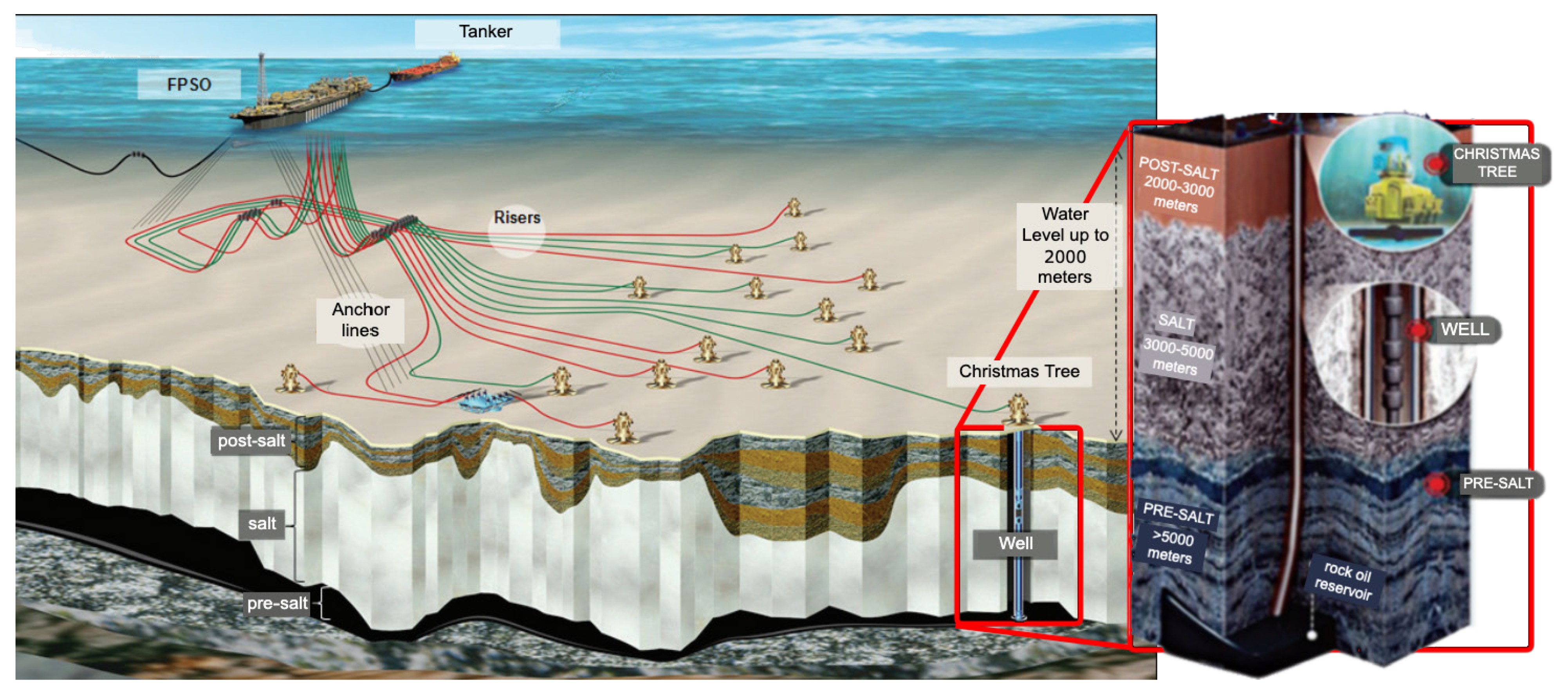
Figure 1 is a graphic representation of floating production storage and offloading vessels and subsea systems (including anchor lines, risers, Christmas trees, and wells). It also illustrates the depth of the pre-salt operation (which permeates through 2000 m of water and an additional 5000 m below the ocean floor to reach the pre-salt oil reservoirs). Figure created using images found in [5,8].
The other impact occurring at this stage is on the physical environment, altering the air quality due to atmospheric emissions. The main air pollutants in these emissions are nitrogen oxides (NOx) and sulfur oxides (SOx), carbon monoxide (CO), methane (CH4), carbon dioxide (CO2), particulate matter (MP), and total hydrocarbons. This impact covers a superregional area. Consequently, the dispersion of emissions minimizes the magnitude to a low rating. At this stage, this impact is also considered temporary, short-term, and partially reversible. However, the impact remains of great importance, due to its impact on global warming.

4.3. Stage 2

This project includes the execution of early production systems, six long-term tests, 12 production development projects, and 15 pipeline sections [45] (details of the inciting actions and the environmental impacts for the physical and biotic environment can be found in [38]). The first definitive production project for this stage began in November 2014 in the Sapinhoá field. Its deactivation is expected to be between 2037 and 2043.
Similarly to Stage 1, this stage has three effective impacts: two during the installation phase and one in the operation phase (Table 6). None are rated as being of high magnitude or importance. During installation, the alteration of the seabed, due to the presence of pipelines and underwater equipment, causes a permanent and irreversible impact to the biotic environment. This long-term impact (these pipelines will not be removed from the sea floor) is rated as being of medium importance and magnitude. These pipelines (which have an individual maximum area ranging from 43 to 84 km2; the total area of these subsea structures reaches approximately 746 km2) allow the outflow of gas.
The change in air quality and contribution to the greenhouse effect during the installation process is rated as a small and minor impact, even if permanent and irreversible in the long-term. This impact is both local and superregional in scale. The same impact is present in the operation phase, fitting the same qualifications, except in relation to importance and magnitude, which increase to a medium rating. Emissions occur as a result of combustion processes for power generation (thermal and electrical) and torch gas burning. The main substances emitted in these activities are nitrogen (NOx) and sulfur (SOx) oxides, carbon monoxide (CO), particulate matter (PM), total hydrocarbons (HCT), and the following greenhouse gases: carbon dioxide (CO2), methane (CH4), and nitrous oxides (N2O) [49,50,51]. The Stage 2 EIA has the following average greenhouse gas estimates (Table 4 and Table 5):

4.4. Stage 3

This stage consists of 23 ventures: a long-term test, nine early production systems, a production pilot/short pilot, a long duration pilot (LDP), and 11 production development projects along with gas outflow systems. Similar to the previous stages, Stage 3 also uses floating production storage and offloading vessels with processing plants that separate oil, natural gas, and water (“produced water” or “production water”). In production development projects and long duration pilots, water separated from oil is treated and disposed of at sea. In the case of production development projects, there is also the generation of effluent from production water and the sulfate removal unit (SRU), which reduces the sulfate content of seawater so that it can be injected into the wells. In pre-salt fields, the amount of gas that is allowed to burn corresponds to a volume equal to or less than 3% of the monthly natural gas production associated with the field. The main substances emitted are greenhouse gases: CO2, CH4, N2O, and total hydrocarbons, as well as NOx, SOx, CO, and particulate matter [2,50,51].
Of the 31 effective impacts, 20 occur at this stage (this is partly due to the quality of the EIA, which becomes more detailed at each stage, with a greater comprehension of impacts) (Table 7). However, none of these impacts analyzed are rated as being of high magnitude. Thus, the six most severe are of great importance and average magnitude. Nine are of low magnitude and of little importance. Similar to the other stages, the installation phase has fewer impacts (which are also less severe) than the operation phase.
The most serious impact, unlike the other stages, is the contribution to the greenhouse effect during the installation and operation phase. During navigation until operation begins, floating production storage and offloading units use motor generators for essential power generation. Therefore, regulated pollutants, such as carbon dioxide (CO2), methane (CH4), and nitrous oxide (N2O), are emitted by the engines of support vessels and diesel power generators during installation. Considering the time that these gases can remain in the atmosphere even after the installation phase, this impact is rated as permanent, irreversible, and occurring on a superregional scale. Due to the short period taken by installation activities, this impact is rated as low magnitude, however, because of the environment’s high sensitivity, this impact is rated as being of medium importance.
The operation phase involves the production, treatment, and export of oil and gas in floating production storage and offloading units, which emit regulated pollutants due to fuel gas consumption in turbogenerators, turbochargers, and boilers, as well as the continuous burning of torch gas. During production development projects and long duration pilots, greenhouse gas emissions are continuous for approximately 30 years. Considering that the average life of atmospheric CO2 is over 100 years, this permanent and irreversible impact occurs at a superregional scale, consequently provoking effects on a global level [6,8,51,54]. The EIA addresses this issue: “Brazilian greenhouse gas emissions are about 4% of global emissions and Petrobras Production and Exploration emissions are 0.04% of world emissions (base year 2010), without considering that the greenhouse effect is a problem caused by the increase in atmospheric concentrations of greenhouse gas emissions due to global historical emissions” [55]. While the change in air quality, which contributes to the greenhouse effect, is rated as effectively impacting the climatic environmental factor, which has a high sensitivity, the environmental factor of air itself has a low sensitivity. Consequently, although this change is permanent and of long duration during the operation phase, it is considered reversible, of low magnitude, and minor importance.
Collection and disposal systems cause little significant impact on the morphology of the ocean floor, with low sediment resuspension, limited to its immediate surroundings. These subsea structures remain on the sea floor throughout the duration of this operation. The long-term tests and early production systems operate on one production well, while the short-term pilot requires two wells to be interconnected. The maximum individual area of these submarine structures is approximately 80 km2, while the total area of all submarine structures (considering all 11 Production Development Projects) totals approximately 1040 km2, which is equivalent to approximately 0.3% of the total area of the Santos Basin (350,000 km2). While the long-term tests, early productions systems, and pilot have an impact on a local scale, the long-term pilots and production development projects have a regional impact. Although the interconnection and operation of the wells have an immediate impact during the long-term tests and the early production systems, it is classified as having a long duration for the long-term pilots and production development projects, as it is a permanent impact in these types of operation. Contrastingly, it is a temporary impact for the short-term pilot, and reversible for all floating production storage and offloading vessels, since all structures will be removed at the conclusion of the activities.
The high sensitivity of the nekton community becomes evident through the analysis of the effective impacts during this stage, as it is affected by six impacts (one during installation and five during operation). The disturbance of nekton due to the installation of floating production storage and offloading units and collection and outflow systems is permanent and long-lasting. Despite being reversible, it is rated as being of great importance and medium magnitude. These same classifications apply to the operation phase, where the nekton is again affected by the presence of floating production storage and offloading units and collection and outflow systems, as well as by noise and luminosity. Marine mammals use sound in various ways, especially for communication, recognition of individuals, identification of predators, orientation, navigation, selection of sexual partners, parental care, and social activities. Marine mammals change their behavior due to anthropogenic sounds (marine mammals’ extreme hearing sensitivity perceives noises that differentiate in 1 dB above background noise), affecting their ability to perceive sounds produced by other mammals and echolocation pulses. It also hinders their detection of important natural sounds, in addition to altering their submersion time and deviating migratory routes. Depending on the frequency, intensity, and duration, the potential effects of anthropogenic sounds on marine mammals range from physical injuries to physiological disturbances (temporary or permanent loss of hearing sensitivity), from behavioral changes (dietary pattern, dispersion of groups, stranding) to interferences in environmental perception, which can all eventually be fatal [55].
The light generated during installation and operation attracts animals with positive phototropism (ranging from fish to birds). Some birds that have nocturnal behavior are attracted to the light during the night, fatally colliding and, in some cases, incinerating (on the flames of the torch gas burners/flares).
The progressive presence of FPSOs and subsea equipment during the installation phase provides a consolidated substrate for benthic organisms to attach to, consequently developing an ecological succession around the equipment, culminating in attracting pelagic and demersal species. The units function as a “temporary artificial reef”, providing shelter, through shading and increasing the food supply (increased by anthropogenic sanitary effluents and food residues) for fish, turtles, and cetaceans (as well as birds) that concentrate around the structures. The platform therefore becomes an area with differentiated biodiversity and biomass, functioning as an efficient fauna attractor. Thus, in addition to changing the configuration of the benthos on the sea floor, the structures of the FPSO encourage the presence of benthic species and associated fauna throughout the column, up to the surface, significantly increasing the trophic complexity surrounding the platforms and altering the populations’ behavior.
The production water, discharged during the long-term pilot and production development project as well as in the operation phase, alters the water around the FPSOs. Even at low concentrations, the water-soluble fractions of hydrocarbons associated with other elements, especially metals, may affect more sensitive components of the biological community in the plume’s area of influence. Contaminated organisms can transfer contaminants to their predators. Effluent discharge from produced water and from the sulfate removal unit permanently affects the nekton and plankton community in the long-term, but is rated as being of low magnitude, as it is reversible. This action has the same impact on the aquatic environment, causing changes in the quality of ocean water.
Seabird disturbances are all permanent and long-term, but reversible. Light generation provokes a more severe impact, being of great importance and medium magnitude, while the presence of floating production storage and offloading vessels cause a disturbance of medium importance and low magnitude.
The benthic community is most affected during the installation phase, losing its habitat due to the pre-anchoring of the floating production storage and offloading vessels and the collection and runoff lines. The presence of these structures and equipment on the seabed prevents and restricts the benthic community, especially the epifauna (which lives on the surface of the unconsolidated substrate). The anchors placed for the production development projects will not be removed after deactivation, causing continuous, long-term local disturbance. Although any anchoring activity results in the loss of habitat, after anchoring, the benthic community is expected to quickly recolonize the substrate surrounding these structures. However, the constant movement of the moorings (due to the water column dynamics) may hinder the re-colonization of the benthic fauna. This impact is the least severe of all the impacts corresponding to this stage: although irreversible (since the anchors and torpedoes will not be removed), all other indicators are rated at the least severe level. Comparatively, the presence of floating production storage and offloading units and collection and outflow lines causes the most severe impact on the benthos, being permanent and long-term, but of medium importance and magnitude, because it is reversible. The installation of the drainage system is also permanent, causing long-term repercussions to the benthic community, but reversible and of low magnitude and importance—since the benthic habitat is on the seafloor, changing the morphology of this physical environment is also classified as an impact with the same definitions. The fine sediments (silt and clay) of the marine substrate will resuspend, due to the installation of underwater structures and gas pipelines, before decanting. Disturbing underwater sediment results in changes that can be felt by the benthic community at different intensities. Sessile organisms, which remain fixed on the seabed, are most likely to die from the mechanical impact or due to asphyxiation from the resuspended sediment (especially filtering organisms). Motile organisms are most likely to react to any approaching structures, moving away from fatal danger. It is important to note that there is little work on the benthic community in the area of study and that it was found to have a low population density. Collected samples at 30 stations (between 2000 and 2425 m) found 46 individuals, belonging to 22 species of 10 taxonomic groups of the zoobenthos. Most abundantly, bivalve mollusks and crustaceans represented six species. Polychaetae annelids make up four species, while the other groups made up one or two species [55].
Thus, the following actions, which are a consequence of oil and gas processing, cause (20) permanent and long-term (and three irreversible) impacts on the (six) physical and (14) biotic systems: the installation of floating production storage and offloading vessels, collection and flow systems, light and noise from operations, discharge of effluent from sulfate removal units, discharge of effluent from produced water, and atmospheric emissions.
Table 7. Effective Impacts during Stage 3.
ImpactEnvResScalePermDurRevMagImp
Change in the seafloor’s morphology due to the installation of collection and disposal systemsP: TeEaRPeLReLoLi
Contribution to the greenhouse effect (installation)P: AeArSRPeLIrLoLi
Alteration of the quality of ocean water due to the disposal of produced waterP: AqWRPeLReMM
Change in the quality of ocean water due to effluents discharged from the sulfate removal unitP: AqWLcPeLReLoLi
Change in air qualityP: AeArRPeLReLoLi
Contribution to the greenhouse effect (operation)P: AeArSRPeLIrMG
Loss of benthic habitat due to pre-anchoring of FPSOs and collection and runoff linesB: AqFa/FlLcTSIrLoLi
Loss of benthic habitat due to the installation of collection and drainage systemsB: AqFa/FlRPeLReLoLi
Disturbance in the benthic community due to perturbation of the sediment during the installation of collection and drainage systemsB: AqFa/FlRPeLReLoLi
Disturbance of the nekton due to the installation of FPSOs and collection and disposal systemsB: AqFaLcPeLReMG
Disturbance in the benthic community due to the presence of FPSOs and collection and disposal systemsB: AqFa/FlRPeLReMM
Disturbance in the planktonic community due to the release of effluent from produced waterB: AqFa/FlRPeLReLoLi
Disturbance in the planktonic community due to the discharge of effluent from the sulfate removal unitB: AqFa/FlLcPeLReLoLi
Disturbance of the nekton due to excessive noiseB: AqFaRPeLReMG
Disturbance in the nekton due to discharge of effluent from produced waterB: AqFaRPeLReLoM
Disturbance in the nekton due to discharge of effluent from the sulfate removal unitB: AqFaLcPeLReLoM
Disturbance in the nekton due to excessive lightB: AqFaLcPeLReMG
Disturbance in the nekton due to the presence of FPSOs and the collection and flow systemsB: AqFaLcPeLReMG
Disturbance of seabirds due to excessive lightB: AeFaLcPeLReMG
Disturbance of seabirds due to the presence of FPSOsB: AeFaLcPeLReLoM
Table 7 lists the relevant environmental impacts caused during Stage 3. The key is as follows: Environment (Env): Biotic (B) or Physical (P), Aquatic (Aq), Terrestrial (Te), Aerial (Ae); Resource (Res): Fauna (Fa), Flora (Fl), Air (Ar), Earth (Ea); Water (W); Scale: Local (Lc), Regional (R), Superregional (SR); Permanence (Perm): Temporary (T), Permanent (Pe); Duration (Dur): S, M, L; Reversibility (Rev): Re, PR, Ir; Magnitude (Mag): Lo, M, H; Importance (Imp): Li, M, G. Created based on [8,35,36,55,56,57,58].

5. Consolidating the Architecture of Potential Impacts

The potential impacts (addressed in the EIA/RIMAs of the drilling activities as well as Stages 1, 2, and 3 of the project) generally refer to chemical spills, mostly during the operation phase of each stage. Of the 22 potential impacts, 18 are rated as being of major importance, 15 of which are of high, five of medium, and two of low magnitude. Of the other impacts, two are of medium importance and medium magnitude, and the other two are of minor importance and low magnitude. These remaining four are considered to be long-lasting or irreversible. Of the 18 most severe, 12 may act on the vulnerability of the biotic environment and six on the physical environment.

5.1. Drilling

A blowout, due to mechanical or operational failures that lead to the loss of control of a well, causes a large volume of crude oil to leak directly into the environment, impacting vulnerable factors [5,59] (the environmental vulnerability map for this project is found in [41]). When leaked, oil undergoes continuous weathering processes, which change its chemical composition, physical characteristics, and behavior in the environment. These processes are directly influenced by local conditions such as currents, water depth, tides, wave energy, temperature, light intensity, and winds. The oceanographic and meteorological conditions at the site at the time of an oil spill have a major influence on the dispersion of the oil slick, making it difficult to predict its behavior. In the case of oil spills, these are usually contained physically, through containment barriers and oil collectors, or chemically by using dispersants, for example. The potential impacts of an oil spill act on environmental components (coastal ecosystems of the project’s area of indirect influence) or environmental factors (marine biota, for example). An oil spill can affect organisms directly (through contact and ingestion) or indirectly (by changing their habitat and contaminating their food). In case of oil spillage, the water’s surface layer is the most affected, completely altering its color, odor, and transparency. The potential consequences analyzed in this project’s EIA only take into account the worst-case blowout scenario. In this study, there are six potential impacts during the drilling operation phase. All are of great importance and high magnitude, except for impacts referring to interference in the restinga areas, which are of medium magnitude. Although the restinga is an environment of extreme biological importance, the impacts on it are temporary, short-term, and partially reversible, as alterations are induced in the biota due to biomagnification.
Mangrove and estuary ecosystems are also considered highly important, because they are nurseries for various species of fish and crustaceans (in addition to their high biological productivity) [49]. These environments are considered the most sensitive to alterations caused by oil spills [5]. Mangrove flora, for example, are extremely affected in the event of an oil spill, as they have aerial roots (pneumatophores) and are located in wetlands in the intertidal zone. Consequently, oil covers the aerial roots, damaging the flora and reducing the available habitat for fauna. Estuaries and mangroves are especially fragile due to their complex dynamism and physical characteristics. Thus, when altered by natural or anthropogenic disturbances, these ecosystems can suffer irreversible damage. Oil spills in mangroves and estuaries can cause a reduction in respiration and photosynthesis rates, affecting productivity; defoliation; abortion of propagules; changes in leaf size; gall formation and leaf malformations; an initial increase in the amount of seeds as a reaction to stress; bioaccumulation in the food chain, particularly in detritivorous species; and impacts on the accompanying fauna, as a result of chemical stress (as well as by ingestion and/or inhalation of toxic vapors) and physical covering. Burrows and galleries of crustaceans and other invertebrates are routes of contamination into the deeper layers of sediment and affect the benthic fauna, especially crabs, which are frequently present in high population densities. If this does not result directly in death from intoxication or physical covering, the oil can dislodge these animals, making them susceptible to predators and other stresses. Since the amount of oxygen in the deepest sediment is very low, the oil tends to remain in the environment for many years or decades. In addition to the direct impact caused by contact with oil, these environments are disturbed by remedial actions that, in many cases, if not chosen for ecological convenience, end up causing more damage to ecosystems than the spill itself. These range from low pressure or vacuum water blasting, to the use of dispersants. However, such measures do not completely remove the oil and can cause physical damage to the environment by trampling and overturning the substrate, which leads to a greater penetration of the oil into the sediment, in addition to contamination of adjacent areas by the blasted oil that is not collected. Additionally, the use of dispersants can lead to intoxication, causing death or sublethal effects on organisms by altering their metabolism, affecting their reproduction and growth. Thus, these impacts cause permanent and partially reversible damage by acting in an area that, despite having a good degree of resilience, is significantly weakened with each impact, making it increasingly vulnerable.
Rocky shores stand out among coastal environments because of their high specificity and the great variety of species of economic and ecological value, such as mussels, oysters, crustaceans, and a wide variety of fish. These coastal marine ecosystems are under the influence of abiotic factors, such as differences in temperature, humidity, irradiance, latitude, tide levels, and gradient of emersion/dissection, as well as biotic factors, such as competition, predation, parasitism, and mutualism. This, consequently, forces the inhabiting life forms to develop peculiar adaptations, resulting in vertical and horizontal zonation patterns of species occurrence and distribution. Rocky shores make up almost the entire extension of the area that could potentially be affected by an oil spill. The hydrodynamic actions of waves cause regions of exposed rocky shores to have a higher recovery rate, in general, than sheltered shores. Although interferences on rocky shores are temporary and short-term, they are exacerbated if oil is bioaccumulated by organisms that can be consumed by others of higher trophic levels. Therefore, the main changes in the community structure of rocky shores include the death of some species of algae (which are the base of the trophic network) in addition to mollusks and crustaceans. As a result, this can cause biomagnification if it reaches the top of the food chain (such as humans) by concentrating contaminants that have toxic effects.
The National System of Nature Conservation Units (SNUC, Sistema Nacional de Unidades de Conservação da Natureza), established by Law 9985 from July 18, 2000, and regulated by Decree 4340/02, defines: “Conservation Unit (CU) as the territorial space and its environmental resources, including jurisdictional waters, with relevant natural characteristics, legally established by the Government, with conservation objectives and defined limits, under special management regime, which apply adequate guarantees for protection” [40].
The delimitation of the drilling activities’ area of indirect influence in the AGBS was defined by considering the areas that could potentially be affected by an accidental oil spill. These were based on the probabilistic modeling of oil dispersion, contemplating worst case scenarios of spillage in the 12 points that form the polygon delimiting AGBS [5,42]. In the worst-case spill scenario (Figure 2), all conservation units in the Área Geográfica Bacia de Santos’ area of indirect influence would be hit by the oil slick, thus having a permanent and irreversible impact. Similarly, benthic communities are permanently affected, as contamination of the sediments in which they live and feed is long-lasting. The impact is also exacerbated due to the relationship between benthic communities and other affected species in the ecosystem, being considered, in this case, of long duration. Filtering and detritivorous organisms are particularly affected by the accumulation of dissolved and sedimented pollutants in their tissues, potentially leading to their intoxication (through the ingestion of contaminated particles or organisms) and coating (respiratory organs and tissues, for example). This reduces the number of species and local biomass. Consequently, these effects cause changes in the community structure, favoring opportunistic species (more resistant to oil pollution). The toxicity effects of oil can be felt immediately (acute) or long term (chronic or sublethal), potentially affecting the physiology, behavior, and reproduction of species.
Figure 2 is a map illustrating the probability of oil in the water and potentially affected coastal areas. For the delimitation of the area of indirect influence, hypothetical accidents were considered, in a worst-case scenario involving the spill of crude oil and marine diesel in the sea, in the 12 corners that form the AGBS polygon, for 30 days without any action being taken to control or decrease it. The trajectories of oil stains, for winter and summer, were defined through simulations, with 300 of them being carried out for the EIA/RIMA studies. The area where the simulation results overlapped were considered regarding the impacts on the physical and biotic environment [5].
Of the six potential impacts analyzed, all occur within the biotic environment, except for the change in water quality, which impacts the physical environment. The aquatic environment, similarly to air, has the quality of dispersing pollutants, diluting them and reducing the intensity of interference. For this reason, the impact on water quality is temporary and partially reversible. This impact is what leads to the other impacts above, as the stain propagates through water, making it of such high importance and magnitude. The chemical composition of oil influences the processes of removing it from the environment (through biodegradation, evaporation, and dilution). Hydrocarbon evaporation is mostly influenced by vapor pressure and molecular weight (hydrocarbons with a lower molecular weight have a higher rate of evaporation than those that are heavier). Evaporation is one of the main processes of removing the oil mass from water (can be responsible for more than 75% of spilled oil volume loss) in the case of light oils. The hydrocarbon’s molecular weight also directly affects its solubility (hydrocarbons of lighter molecular weight are more hydro-soluble). This poses a greater danger, as hydrocarbons that have a lighter and medium molecular weight tend to be more toxic than their heavier counterparts. Furthermore, oil spills introduce metals and organic compounds into the environment; most compounds contain sulfur, nitrogen, nickel, and vanadium. In case of a blowout, a hydrocarbon vapor plume would form immediately, reaching its highest concentration after the end of the incident, when the entire volume of oil would be exposed to the atmosphere. This could potentially cause a photochemical smog plume to form, highly concentrated in fine particulate matter and pollutants such as SO2, NOx, CO, and O3.
It can be concluded that a blowout in the drilling stage (Table 8) would lead to serious consequences mainly for the aquatic environment, increasing the vulnerability of all biota with which it comes in contact [5].

5.2. Stage 1

Potential impacts identified in this stage refer to possible chemical and/or fuel leaks at sea and/or a possible crude oil leak. All potential impacts are detailed in [47]. The comprehensive analysis of AGBS’ environmental vulnerability to an oil leak for this stage can be found in [48], and a map of it in [43].
This study found eight potential impacts at this stage (Table 9) that are rated as permanent, long-lasting, or irreversible. Two affect the biotic environment, while the other six affect the physical environment. Again, air quality is assessed as least altered, the impact being temporary, short-term, partially reversible, and of medium importance and magnitude. This stage’s EIA delineates that: “In the event of an oil spill accident, a hydrocarbon vapor plume is formed from the outset, due to the high volatility of oil components’ lower molecular weight, such as BTEX (benzene, toluene, ethylene, xylene). According to hydrocarbon concentrations, a photochemical plume of smog could be formed by the presence of high concentrations of fine particulate matter and pollutants such as: SO2, NOx, CO, and O3” [47]. This plume can cause a series of impacts on human and animal health in general [49]. The change in water quality is classified similarly to that in air, except that, since it includes areas with “very high” to “extremely high” conservation priority status, it is rated as being of great importance and magnitude. Considering the likelihood of oil spills on the coast as well as in the ocean regions, there are a large number of conservation units (about 135) that could be hit in a worst-case spill. Interference to conservation units—which are areas of high vulnerability—is rated as permanent and irreversible, consequently being of high magnitude and importance.
Benthic communities’ high sensitivity makes them exceedingly vulnerable to this type of long-term impact, causing permanent alteration, which classifies this partially reversible impact as being of high magnitude and great importance. Seabirds and coastal birds, another biotic environmental factor, also suffer alteration, classifying the impact on this community as being of high importance and magnitude. The main effects of oil on birds occur through direct physical contact, which causes their feathers to lose their impermeable quality (hindering or preventing flight). Furthermore, the ingestion of petroleum compounds can also be fatal, occurring mainly during the birds’ attempt to clean themselves. However, since they are not in direct contact with the spill (such as aquatic organisms) and have a migratory capacity, they are only temporarily affected for what is considered a medium duration. All organisms that live in the shallow layers of the sea, including seabirds and coastal birds, are especially vulnerable to oil spills.
Of the three remaining impacts to the physical environment—all of high magnitude and importance—the interference to the restinga areas is the least severe, as they are temporary, of medium duration, and partially reversible. Even so, restingas are classified as priority areas for conservation, given their ecological functions and extreme biological importance [47]. Depending on the oceanographic and meteorological conditions at the time of the accident, and considering the characteristics of the region’s coast, the oil could directly reach part of the restinga vegetation that is in contact with the beach. Furthermore, according to the intensity of the spill, these considerations may also apply to the contact areas between estuaries and sandbanks. As already analyzed, the mangrove and estuary areas have a high sensitivity and vulnerability. Thus, this interference causes permanent impacts, with partially reversible damage being therefore of high importance and magnitude. Similarly, even temporary interference with rocky shores may be irreversible. These harbor a wide variety of species of economic and ecological value.

5.3. Stage 2

For the focus of this study, there are four impacts analyzed at this stage (Table 10), all of which may occur in the operation phase and three in the installation phase. The only impact on the physical environment refers to the change in water quality caused by chemical leaks. Although this impact is irreversible, it is temporary in nature. Due to the high dilution quality of this local impact, it is rated as being of low importance and magnitude. Long-term damage to mangroves and estuaries, due to fuel and oil spills at sea, is of great importance and of medium magnitude, despite being reversible and temporary. The detailed analysis of AGBS’ environmental vulnerability to an oil leak developed for the Stage 2 project can be found in [52]. It defines, “ecologically sensitive areas with high ISL (Índice de Sensibilidade do Litoral, or Coastal Sensitivity Index) (8–10), such as estuaries, mangroves, coastal lagoons, marshes, and wetlands, as well as identified coastal and marine protected areas”. At this stage, there are about 143 Conservation Units that could be reached in an oil spill at the Área Geográfica Bacia de Santos.
However, the most serious impact refers to the change in the marine environment due to the introduction of exotic species through support vessels, both for installation, operation, and decommissioning of oil and natural gas production, disposal, and outflow activities. These can carry a variety of invasive species in significant quantities. Most of these bio invaders belong to the benthic community. Once again, the benthic community’s high sensitivity makes it more vulnerable to this impact, but it is not the only one affected. The consequences of introducing exotic species are long-lasting, permanent, and may be irreversible. Therefore, this is an impact of high magnitude and importance.
Aspects that generate impacts that disturb seabirds and marine animals range from light generation to the presence of Floating Production Storage and Offloading units and subsea equipment. Birds have an average sensitivity to this type of impact. Although these impacts are temporary, reversible, and of medium magnitude and importance, they are long lasting.
Thus, despite the few potential impacts at this stage, they act significantly on the vulnerability of the biological environment.

5.4. Stage 3

The detailed analysis of AGBS’ environmental vulnerability to an oil spill, updated for Stage 3, can be found in [56], first semester map—[57], second semester map—[58], and identification/assessment of general impacts [55].
Four potential impacts are addressed at this stage due to the nature of this study, which analyzes only permanent, irreversible, or long-term impacts. All except for one of these four are severe, seriously threatening the environmental vulnerability. Two of these refer to an environmental vulnerability to bio invasion. The introduction and/or dissemination of invasive alien species in the coastal benthic community via transport of floating production storage and offloading units during the installation phase causes a serious impact, as it is permanent, irreversible, long lasting, and of high magnitude and importance. The same proportions apply to the introduction and/or dissemination of invasive alien species via transit from support vessels during the installation phase—while similar to the previous impact, this is understood as one that compromises marine biotic communities (not just benthos), thus having a broader impact, including to conservation units (Figure 3). Meanwhile, the same impact during the operation phase maintains the same levels, but with medium magnitude.
Figure 3 is a map of areas where the conservation of biodiversity was considered a priority according to the Ministry of Environment. The map distinguishes areas and respective levels of biological importance, as well as the priority for action [8].
The presence of floating production storage and offloading units during the operation phase also has the potential to introduce and/or disseminate invasive alien species in the benthic community. However, this impact during this phase is considered of low magnitude and importance, although the biological implications are long-lasting and permanent, remaining until the project’s deactivation, although they can be reversible when the hull is cleaned and moved to another area or activity [55].
At this stage (Table 11), the vulnerability of the biotic environment is the most threatened, especially with regard to the benthic community.

6. Exploring Vulnerabilities in Order to Understand Environmental Impacts

One challenge of analyzing environmental vulnerability sourcing from different projects is that the criteria and methodologies of EIAs vary between stages. Ideally this study would have created a quantitative environmental vulnerability index, but these variations would not guarantee its reliability. At times the variation is so drastic that the same impact can have a completely different rating from one stage to another, despite referring to the same area and the same impact. For example, the impact referring to change in air quality is considered a potential impact in the operational phase of Stage 1, while it is an effective impact in the operational phase of Stage 3. While in Stage 1 it is rated as being temporary, of short-term duration, partially reversible, and of medium magnitude and importance, Stage 3 is rated as being permanent, long-term, reversible, and of low magnitude and little importance. There are also analytical discrepancies within each stage: for example, in the analysis of potential impacts from Stage 3, the benthic community is considered to have both high and low sensitivity to the introduction of alien species [55]. This may be due to the broader interpretation of some environmental factors: for example, when a community is made up of a large number of species, such as benthos, generalizing the consequences of an impact is not true to its vulnerability. Analyzing the entire benthic community as one means grouping sessile and motile organisms. As previously discussed, sessile organisms remain fixed on the seabed and cannot move away from fatal danger, while motile organisms are likely to react to any approaching structures and have a better chance to survive mechanical impacts, for example, and the consequent sediment disruption. Additionally, these organisms can be vulnerable to different consequences of the same impact. For example, mechanical impacts can crush sessile organisms, while a motile filtering organism can die due to asphyxiation. As there is little work on the benthic community in the area of study, we recommend they receive more careful and deeper study in order to better understand their vulnerability to the impacts of these types of ventures.
In Stage 2’s EIA, sensitivity is more specifically defined as, “a measure of the susceptibility of an environmental factor to impacts in general, and the importance of this factor in the ecosystemic context. Therefore, it is observed that sensitivity is intrinsic to the environmental factor. That is, it is not related to an impact on the environmental factor” [49]. However, it is a fact that each environmental factor will have different levels of sensitivity to each impact. For example, communities that may be sensitive to impacts caused by noise or lighting may be resistant to bio invaders or oil spills. Thus, the environmental vulnerability maps presented in these EIAs refer only to oil vulnerability, not to other impacts. The 2004 EVI [39], for example, analyzes countries’ environmental vulnerability using 50 indicators, each specific to each impact (from climate to policy). A future study may come to understand each factor in detail in order to create a faithful index.
Some of these discrepancies between stages make clear the evolution of human understanding in relation to environmental impacts and how they affect vulnerable systems. For example, the frequency indicator is crucial for risk analysis (“considering that risk is a function of the frequency of occurrence of possible accidents and the damage (consequences) generated by these unwanted events” [53]), but in the EIA it does not come as a de facto indicator until Stage 2, and evolves considerably between Stage 2 and 3. Furthermore, while the drilling stage only analyzes consequences of a blowout, the other stages are more conservative with regard to interpretation of accidental impacts. Again, this highlights the difficulty of creating a faithful environmental vulnerability index to analyze these projects. Despite not having a quantitative environmental vulnerability index, resulting in an environmental vulnerability “score”, this analysis of the results allows a qualitative view of environmental vulnerability. For example, one can conclude that the vulnerability of the biotic environment is the most threatened by actual and potential impacts. In short, the environmental factors in the physical environment that have their vulnerability affected are sediment (from the deepest to the most superficial), oceanic water, coastal water, the weather, and the air. In the biotic environment, affected factors are the benthic community, the planktonic community, the nekton, seabirds, the marine biota, the rocky shores, the sandy beaches, the mangroves, and the everglades. As analyzed in the drilling stage’s effective impacts, the only positive environmental impact in the survey of this study is the demobilization of the equipment. Even this has negative impacts, such as exterminating life that may have colonized on equipment. Environmental factors affected by reversible impacts only recover once the activity is concluded. Thus, the end of this type of exploitation would result in a positive impact on systems’ environmental vulnerability in the Área Geográfica Bacia de Santos (and beyond). The RIMA for Stage 1 concludes that: “The non-execution of the activity has positive and negative points. Among the positives, it is noteworthy that the absence of the Projects in the Pre-Salt Reservoirs would contribute to the non-alteration of the environmental quality in the project locations, as well as encourage the search for renewable sources of energy (solar, wind, biodiesel, ethanol, etc.), as oil is a resource that may end due to its widespread use” [44]. In order to extract natural resources, it is necessary to know how the environment reacts to imposed anthropogenic pressures, as well as the degree of support for these pressures [60]. These resources, as discussed above, cause a wide variety of environmental impacts, which irreversibly compromise the ability of future generations to meet their own needs, endangering the environmental vulnerability of the Área Geográfica Bacia de Santos system [2,3,11]. Thus, with regard to the exploitation of natural resources, there are alternatives that can save the environmental factors studied above from these risks [2,3,10]. It is known that various reviews and studies are carried out around the world about environmental vulnerability (with varying degrees of analysis and accuracy, published or not), aiming at the diffuse goal of sustainable development and others such as the objectives of the millennium, as found in [13,14,15,16,25,26,28,61,62]. “Although modern society needs a series of petroleum products in order to be fully functional, coupled with this dependence, there must be a corresponding responsibility to manage these products effectively and safely in order to prevent environmental disasters” [60]. With such clear evidence of the large-scale and permanent impacts on the environmental vulnerability caused by pre-salt oil and gas ventures, we recommend an urgent investment in less damaging and finite resources.

7. Conclusions and Final Considerations

This study demonstrates that the determination of the environmental vulnerability linked to oil and natural gas extraction is complex and uncertain. However, by associating the three aspects of environmental vulnerability (exposure, resilience, and sensitivity) with the environmental impacts outlined and explored in the EIA/RIMA documents (scale, duration, permanence, reversibility, importance, and magnitude), this study demonstrates that there are a number of anthropic pressures on environmental vulnerability. Although there are a variety of alternative resources for power generation and even for petroleum products, the most practical and convenient alternatives are still used. However, in a world of high demand and a growing population, if we are to follow a path of sustainable development, we must change our habits. Hydrocarbons have devastating impacts even before they are mined from their reservoirs, making environments that are already vulnerable to human impacts become even more sensitive, thereby diminishing their resilience as they are exposed to risks.

Author Contributions

Conceptualization, T.F.M. and M.E.M.U.; Data curation, T.F.M.; Formal analysis, T.F.M., A.L.V.G., E.M.D., M.L.R.P.D.S. and M.E.M.U.; Investigation, T.F.M. and M.E.M.U.; Methodology, T.F.M., A.L.V.G., E.M.D., M.L.R.P.D.S. and M.E.M.U.; Resources, T.F.M., A.L.V.G., E.M.D., M.L.R.P.D.S. and M.E.M.U.; Supervision, A.L.V.G., E.M.D., M.L.R.P.D.S. and M.E.M.U.; Validation, T.F.M., A.L.V.G., E.M.D., M.L.R.P.D.S. and M.E.M.U.; Writing—original draft, T.F.M.; Writing—review & editing, T.F.M. and M.E.M.U. All authors have read and agreed to the published version of the manuscript.

Funding

This research received no external funding.

Acknowledgments

To Stefania Gomes Relva who collaborated with the development of the early report [61], providing conscious insights and analysis, helping this work.

Conflicts of Interest

The authors declare no conflict of interest.

References

  1. Jessen, K.; Laugesen, K.; Mortensen, S.M.; Jensen, J.K.; Soltani, M.N. Experimental Validation of Aero-Hydro-Servo-Elastic Models of a Scaled Floating Offshore Wind Turbine. NATO Adv. Sci. Inst. Ser. E Appl. Sci. 2019, 9, 1244. [Google Scholar] [CrossRef] [Green Version]
  2. Youn, I.-H.; Kim, S.-C. Preventive Maintenance Topic Models for LNG Containment Systems of LNG Marine Carriers Using Dock Specifications. NATO Adv. Sci. Inst. Ser. E Appl. Sci. 2019, 9, 1202. [Google Scholar] [CrossRef] [Green Version]
  3. Mo, Y.; Kearney, M.S.; Riter, J.C.A. Post-Deepwater Horizon Oil Spill Monitoring of Louisiana Salt Marshes Using Landsat Imagery. Remote Sens. 2017, 9, 547. [Google Scholar] [CrossRef] [Green Version]
  4. Garcia-Pineda, O.; Holmes, J.; Rissing, M.; Jones, R.; Wobus, C.; Svejkovsky, J.; Hess, M. Detection of Oil near Shorelines during the Deepwater Horizon Oil Spill Using Synthetic Aperture Radar (SAR). Remote Sens. 2017, 9, 567. [Google Scholar] [CrossRef] [Green Version]
  5. ICF Consulting e BMA. Relatório de Impacto Ambiental-RIMA: Atividade de Perfuração Marítima na Área Geográfica Bacia de Santos; Petrobras: Brasilia, Brazil, 2006. [Google Scholar]
  6. Gamboa, L.; Ferraz, A.; Baptista, R.; Neto, E.V.S. Geotectonic Controls on CO2 Formation and Distribution Processes in the Brazilian Pre-Salt Basins. Geosci. J. 2019, 9, 252. [Google Scholar] [CrossRef] [Green Version]
  7. São Paulo (Estado). Secretaria de Energia e Mineração. In Balanço Energético do Estado de São Paulo 2018; Secretaria de Energia e Mineração: São Paulo, Brazil, 2018. [Google Scholar]
  8. Mineral Engenharia e Meio Ambiente Ltd. Relatório de Impacto Ambiental-RIMA: Atividade de Produção e Escoamento de Petróleo e Gás Natural do Polo Pré-Sal da Bacia de Santos-Etapa 3; Petrobras: Brasilia, Brazil, 2017. [Google Scholar]
  9. Petrobras. Informe Bacia de Santos; Petrobras: Brasilia, Brazil, 2019. [Google Scholar]
  10. Feng, T.-T.; Yang, Y.-S.; Yang, Y.-H.; Wang, D.-D. Application Status and Problem Investigation of Distributed Generation in China: The Case of Natural Gas, Solar and Wind Resources. Sustain. Sci. Pract. Policy 2017, 9, 1022. [Google Scholar] [CrossRef] [Green Version]
  11. Shin, H.; Geem, Z.W. Optimal Design of a Residential Photovoltaic Renewable System in South Korea. NATO Adv. Sci. Inst. Ser. E Appl. Sci. 2019, 9, 1138. [Google Scholar] [CrossRef] [Green Version]
  12. United Nations. Report of the World Commission on Environment and Development: Our Common Future; World Commission on Environment and Development: Oxford, UK, 1987. [Google Scholar]
  13. Shrivastava, P.; Vidhi, R. Pathway to Sustainability in the Mining Industry: A Case Study of Alcoa and Rio Tinto. Resources 2020, 9, 70. [Google Scholar] [CrossRef]
  14. Chen, H.-S.; Liu, W.-Y.; Hsieh, C.-M. Integrating Ecosystem Services and Eco-Security to Assess Sustainable Development in Liuqiu Island. Sustain. Sci. Pract. Policy 2017, 9, 1002. [Google Scholar] [CrossRef] [Green Version]
  15. Njoroge, P.; Ambole, A.; Githira, D.; Outa, G. Steering Energy Transitions through Landscape Governance: Case of Mathare Informal Settlement, Nairobi, Kenya. Land 2020, 9, 206. [Google Scholar] [CrossRef]
  16. Tsinganos, K.; Gerasopoulos, E.; Keramitsoglou, I.; Pirrone, N. The ERA-PLANET Team ERA-PLANET, a European Network for Observing Our Changing Planet. Sustain. Sci. Pract. Policy 2017, 9, 1040. [Google Scholar]
  17. Bradley, M.P.; Smith, E.R. Using Science to Assess Environmental Vulnerabilities. Environ. Monit. Assess. 2004, 94, 1–7. [Google Scholar] [CrossRef] [PubMed]
  18. de Aquino, A.R.; Paletta, F.C.; de Almeida, J.R. Vulnerabilidade Ambiental; Editora Edgard Blücher Ltd.: São Paulo, Brazil, 2017. [Google Scholar]
  19. de Figueiredo, M.C.B.; Vieira, V.; Mota, F.S.B.; de Rosa, M.F.; de Sousa, S.A.M. Análise da Vulnerabilidade Ambiental; Embrapa Agroindústria Tropical-Documentos: Brasilian, Brazil, 2010. [Google Scholar]
  20. Eakin, H.; Luers, A.L. Assessing the Vulnerability of Social-Environmental Systems. Annu. Rev. Environ. Resour. 2006, 31, 365–394. [Google Scholar] [CrossRef] [Green Version]
  21. Kasperson, R.E.; Dow, K.; Archer, E.R.M.; Cáceres, D.; Downing, T.E.; Elmqvist, T.; Eriksen, S.; Folke, C.; Han, G.; Iyengar, K.; et al. Vulnerable Peoples and Places. In Ecosystems and Human Well-Being: Current State and Trends, 9th ed.; Hassan, R., Scholes, R., Ash, N., Eds.; Island Press: Washington, DC, USA, 2005. [Google Scholar]
  22. Luers, A.L. The surface of vulnerability: An analytical framework for examining environmental change. Glob. Environ. Chang. 2005, 15, 214–223. [Google Scholar] [CrossRef]
  23. Turner, B.L. Vulnerability and resilience: Coalescing or paralleling approaches for sustainability science? Glob. Environ. Chang. 2010, 20, 570–576. [Google Scholar] [CrossRef]
  24. Turner, B.L.; Kasperson, R.E.; Matson, P.A.; McCarthy, J.J.; Corell, R.W.; Christensen, L.; Eckley, N.; Kasperson, J.X.; Luers, A.; Martello, M.L.; et al. A framework for vulnerability analysis in sustainability science. Proc. Natl. Acad. Sci. USA 2003, 100, 8074–8079. [Google Scholar] [CrossRef] [Green Version]
  25. Sabrin, S.; Karimi, M.; Nazari, R. Developing Vulnerability Index to Quantify Urban Heat Islands Effects Coupled with Air Pollution: A Case Study of Camden, NJ. ISPRS Int. J. Geo-Inf. 2020, 9, 349. [Google Scholar] [CrossRef]
  26. Wang, X.; Pang, Y.; Wang, X.; Zhou, Q.; Xie, R. Study of Water Environmental Cumulative Risk Assessment Based on Control Unit and Management Platform Application in Plain River Network. Sustain. Sci. Pract. Policy 2017, 9, 975. [Google Scholar] [CrossRef] [Green Version]
  27. Tsou, J.; Gao, Y.; Zhang, Y.; Genyun, S.; Ren, J.; Li, Y. Evaluating Urban Land Carrying Capacity Based on the Ecological Sensitivity Analysis: A Case Study in Hangzhou, China. Remote Sens. 2017, 9, 529. [Google Scholar] [CrossRef] [Green Version]
  28. Kohlitz, J.; Chong, J.; Willetts, J. Rural Drinking Water Safety under Climate Change: The Importance of Addressing Physical, Social, and Environmental Dimensions. Resources 2020, 9, 77. [Google Scholar] [CrossRef]
  29. Brasil, L. Others Resolução CONAMA N001, de 23 janeiro de 1986, Dispõe sobre as diretrizes gerais para uso e implementação de Avaliação de Impacto Ambiental. Brasileira. Diário Oficial; 1986. Available online: http://www.palmares.gov.br/wp-content/uploads/2018/09/res-conama-01-1986.pdf (accessed on 1 June 2019).
  30. ICF Consultoria do Brasil e BMA. EIA/RIMA Atividade de Perfuração Marítima na Área Geográfica Bacia de Santos-Informações de Caráter Ambiental II.4; Petrobras: Brasilia, Brazil, 2006. [Google Scholar]
  31. ICF Consultoria do Brasil. EIA/RIMA-Projetos Integrados de Produção e Escoamento de Petróleo e Gás Natural no Pólo Pré-Sal, Bacia de Santos (Etapa 1) II.5.1-Meio Físico; Petrobras: Brasilia, Brazil, 2010. [Google Scholar]
  32. ICF Consultoria do Brasil. EIA/RIMA Para os Projetos Integrados de Produção e Escoamento de Petróleo e Gás Natural no Pólo Pré-Sal, Bacia de Santos (Etapa 1) II.5.2-Meio Biótico; Petrobras: Brasilia, Brazil, 2010. [Google Scholar]
  33. Mineral Engenharia e Meio Ambiente Ltd. Atividade de Produção e Escoamento de Petróleo e Gás Natural do Polo Pré-Sal da Bacia de Santos (Etapa 2) Diagnóstico Ambiental II.5.1-Meio Físico; Petrobras: Brasilia, Brazil, 2013. [Google Scholar]
  34. Mineral Engenharia e Meio Ambiente Ltd. Atividade de Produção e Escoamento de Petróleo e Gás Natural do Polo Pré-Sal da Bacia de Santos (Etapa 2) Diagnóstico Ambiental II.5.2-Meio Biótico; Petrobras: Brasilia, Brazil, 2013. [Google Scholar]
  35. Mineral Engenharia e Meio Ambiente Ltd. Atividade de Produção e Escoamento de Petróleo e Gás Natural do Polo Pré-Sal da Bacia de Santos (Etapa 3) Diagnóstico Ambiental II.5.1-Meio Físico; Petrobras: Brasilia, Brazil, 2017. [Google Scholar]
  36. Mineral Engenharia e Meio Ambiente Ltd. Atividade de Produção e Escoamento de Petróleo e Gás Natural do Polo Pré-Sal da Bacia de Santos (Etapa 3) Diagnóstico Ambiental II.5.2-Meio Biótico; Petrobras: Brasilia, Brazil, 2017. [Google Scholar]
  37. Mein, T. Anexo Análise de Dados Vulnerabilidade 2019. Available online: https://docs.google.com/spreadsheets/d/1bIVk9bxwoTAaGz7X40yf3vaZFuMGWPwlK0g5sbPxSYo/edit#gid=0 (accessed on 1 June 2019).
  38. Mineral Engenharia e Meio Ambiente Ltd. Atividade de Produção e Escoamento de Petróleo e Gás Natural do Polo Pré-Sal da Bacia de Santos (Etapa 2) Avaliação de Impactos Cumulativos e Sinérgicos Anexo II.9-1; Petrobras: Brasilia, Brazil, 2013. [Google Scholar]
  39. Kaly, U.; Pratt, C.; Mitchell, J. The Environmental Vulnerability Index 2004; South Pacific Applied Geoscience Commission (SOPAC): Suva, Fiji, 2004. [Google Scholar]
  40. ICF Consultoria do Brasil e BMA. EIA/RIMA Atividade de Perfuração Marítima na Área Geográfica Bacia de Santos—Identificação e Avaliação dos Impactos Ambientais II.5; Petrobras: Brasilia, Brazil, 2006. [Google Scholar]
  41. BMP Info Geo. Mapa de Vulnerabilidade; BMP: Brasilia, Brazil, 2006. [Google Scholar]
  42. ICF Consultoria do Brasil e BMA. EIA/RIMA Atividade de Perfuração Marítima na Área Geográfica Bacia de Santos-Caracterização da Atividade II.2; Petrobras: Brasilia, Brazil, 2006. [Google Scholar]
  43. ICF Consultoria do Brasil. Mapa de Vulnerabilidade Ambiental; Petrobras: Brasilia, Brazil, 2012. [Google Scholar]
  44. ICF Consulting. Relatório de Impacto Ambiental-RIMA: Atividade de Produção e Escoamento de Petróleo e Gás Natural do Polo Pré-Sal da Bacia de Santos-Etapa 1; Petrobras: Brasilia, Brazil, 2011. [Google Scholar]
  45. Mineral Engenharia e Meio Ambiente Ltd. Atividade de Produção e Escoamento de Petróleo e Gás Natural do Polo Pré-Sal da Bacia de Santos (Etapa 2) Introdução I; Petrobras: Brasilia, Brazil, 2013. [Google Scholar]
  46. Petrobras. Etapa 1. Comunicação Bacia de Santos. Available online: https://www.comunicabaciadesantos.com.br/empreendimento/etapa-1 (accessed on 27 June 2019).
  47. ICF Consultoria do Brasil. EIA/RIMA Para a Atividade de Produção e Escoamento de Petróleo e Gás Natural do Polo Pré-Sal da Bacia de Santos (Etapa 1) II.6-Identificação e Avaliação de Impactos; Portuguese: Brasilia, Brazil, 2012. [Google Scholar]
  48. ICF Consultoria do Brasil. Plano de Emergencia para Vazamento de Óleo na Área Geográfica Bacia de Santos (Etapa 1) Anexo II.2.1-1 Análise de Vulnerabilidade; Petrobras: Brasilia, Brazil, 2010. [Google Scholar]
  49. Mineral Engenharia e Meio Ambiente Ltd. Atividade de Produção e Escoamento de Petróleo e Gás Natural do Polo Pré-Sal da Bacia de Santos (Etapa 2) Identificação e Avaliação de Impactos II.6; Petrobras: Brasilia, Brazil, 2013. [Google Scholar]
  50. Iliuta, I.; Larachi, F. Modeling and Simulations of NOx and SO2 Seawater Scrubbing in Packed-Bed Columns for Marine Applications. Catalysts 2019, 9, 489. [Google Scholar] [CrossRef] [Green Version]
  51. Jiang, X.-T.; Li, R. Decoupling and Decomposition Analysis of Carbon Emissions from Electric Output in the United States. Sustain. Sci. Pract. Policy 2017, 9, 886. [Google Scholar] [CrossRef] [Green Version]
  52. Tetra Tech. Plano de Emergencia para Vazamento de Óleo na Área Geográfica Bacia de Santos (Etapa 2) Anexo II.2.1-1 Análise de Vulnerabilidade; Petrobras: Brasilia, Brazil, 2015. [Google Scholar]
  53. Mineral Engenharia e Meio Ambiente Ltd. Atividade de Produção e Escoamento de Petróleo e Gás Natural do Polo Pré-Sal da Bacia de Santos (Etapa 2) Análise e Gerenciamento de Risco II.10.1; Petrobras: Brasilia, Brazil, 2013. [Google Scholar]
  54. Liu, Q.; Zhu, D.; Jin, Z.; Meng, Q.; Wu, X.; Yu, H. Effects of deep CO2 on petroleum and thermal alteration: The case of the Huangqiao oil and gas field. Chem. Geol. 2017, 469, 214–229. [Google Scholar] [CrossRef]
  55. Mineral Engenharia e Meio Ambiente Ltd. Atividade de Produção e Escoamento de Petróleo e Gás Natural do Polo Pré-Sal da Bacia de Santos (Etapa 3) Identificação e Avaliação de Impactos Ambientais II.6; Petrobras: Brasilia, Brazil, 2017. [Google Scholar]
  56. Mineral Engenharia e Meio Ambiente Ltd. Atividade de Produção e Escoamento de Petróleo e Gás Natural do Polo Pré-Sal da Bacia de Santos (Etapa 3) Anexo II.10.4.2.1-1-Análise de Vulnerabilidade; Petrobras: Brasilia, Brazil, 2017. [Google Scholar]
  57. Mineral Engenharia e Meio Ambiente Ltd. Vulnerabilidade Ambiental-Integrado Primeiro Semestre; Petrobras: Brasilia, Brazil, 2017. [Google Scholar]
  58. Mineral Engenharia e Meio Ambiente Ltd. Vulnerabilidade Ambiental-Integrado Segundo Semestre; Petrobras: Brasilia, Brazil, 2017. [Google Scholar]
  59. Shafiee, M.; Enjema, E.; Kolios, A. An Integrated FTA-FMEA Model for Risk Analysis of Engineering Systems: A Case Study of Subsea Blowout Preventers. NATO Adv. Sci. Inst. Ser. E Appl. Sci. 2019, 9, 1192. [Google Scholar] [CrossRef] [Green Version]
  60. dos Santos Costa, F.H.; Petta, R.A.; de Souza Lima, R.F.; de Medeiros, C.N. Determinação da vulnerabilidade ambiental na bacia potiguar, região de Macau (RN), utilizando sistemas de informações geográficas. Rev. Bras. Cartogr. 2006, 58, 119–127. [Google Scholar]
  61. Mein, T.F.; Gimenes, A.L.V.; Udaeta, M.E.M.; Dias, E.M.; Relva, S.G. Análise de Vulnerabilidade Ambiental Para Uma Escolha Mais Sustentável de Recursos Para Produção de Energia Elétrica; Unpublished End-Report Produced for the Postgraduate Academic Unit PEA7567 Advanced Topics in Energy Systems for Clean Development; PPGEE/EP Universidade de São Paulo: São Paulo, Brazil, 2019. [Google Scholar]
  62. Mein, T.F.; Gimenes, A.L.V.; Udaeta, M.E.M.; Dias, E.M.; Relva, S.G. Issues in Energy Vulnerability Assessment: Looking for a Sustainable Choice of Natural Resource for Power Generation. Proceedings 2020, 58, 30. [Google Scholar] [CrossRef]
Figure 1. Graphic representation of FPSO and subsea systems.
Energies 14 00732 g001
Figure 2. Probability of oil in the water and potentially affected coastal area.
Energies 14 00732 g002
Figure 3. Priority areas for conservation of biodiversity according to the Ministry of Environment.
Energies 14 00732 g003
Table 1. The EIA/RIMA (Environmental Impact Study/Environmental Impact Report) definitions, quantifications, and qualifications used in this study.
ClassEffectiveWhen the impact is 100% likely to occur
PotentialWhen an impact has a probability of occurring that is less than 100%
NaturePositiveWhen the quality of the affected environmental factor (Specific definitions of environmental factors: [38]) represents improvement
NegativeWhen there is a deterioration in the quality of the environmental factor affected
ScaleLocalImpact occurring up to 5 km from project site
RegionalImpact occurring beyond 5 km from project site
SuperregionalImpact occurs on national, continental, or global scale
Duration: Indicates for how long the impact will change the characteristics of the environmental factor.ShortImpact has a duration of up to 15 years
MediumImpact’s duration is between 15 and 30 years
LongImpact’s duration is over 30 years
PermanenceTemporaryClassified as short and medium duration
PermanentClassified as long duration
ReversibilityReversibleThe environmental factor may return to the same conditions as prior to impact
Partially ReversibleThe environmental factor may partially return to the same conditions as prior to impact
IrreversibleThe environmental factor cannot return to the same conditions as prior to impact
MagnitudeLowDetermines the intensity or magnitude of the impact in relation to the alteration it causes
Medium
High
ImportanceLittleRelevance of an impact assessed by combining the environmental factor’s sensitivity with impact’s magnitude
Medium
Great
Table 2. Effective impacts during drilling stage.
ImpactEnvResScalePermDurRevMagImp
Alteration of marine biota by demobilization of the drilling rigB: AqFa/FlSRPeSIrHG
Alteration of marine biota due to the introduction of exotic speciesB: AqFa/FlSRPeSIrH/LG/Li
Alteration of the benthic community due to the disposal of gravel with attached drilling fluidB: AqFa/FlLcTLReHM
Alteration of the benthic community due to the demobilization of the drilling rigB: AqFa/FlLcPeLIrLLi
Alteration of the pelagic community due to the demobilization of the drilling rigB: AqFa/FlRPeSIrLLi
Table 2 lists the relevant environmental impacts caused during the drilling stage. The key is as follows: Environment (Env): Biotic (B) or Physical (P), Aquatic (Aq), Terrestrial (Te), Aerial (Ae); Resource (Res): Fauna (Fa), Flora (Fl), Air (Ar), Earth (Ea); Water (W); Scale: Local (Lc), Regional (R), Superregional (SR); Permanence (Perm): Temporary (T), Permanent (Pe); Duration (Dur): S, M, L; Reversibility (Rev): Re, PR, Ir; Magnitude (Mag): Lo, M, H; Importance (Imp): Li, M, G. Created based on [5,30,40,41,42,43].
Table 3. Effective Impacts during Stage 1.
ImpactEnvResScalePermDurRevMagImp
Alteration of marine biota by introducing exotic species by anchoring FPSOs and installing underwater systemsB: AqFa/FlSRPeMIrMG
Change in air quality caused by air emissionsP: AeArSRTSPRLoG
Alteration of the benthic community due to the removal of FPSOs and subsea systemsB: AqFa/FlLcPeSIrMM
Table 3 lists the relevant environmental impacts caused during Stage 1. The key is as follows: Environment (Env): Biotic (B) or Physical (P), Aquatic (Aq), Terrestrial (Te), Aerial (Ae); Resource (Res): Fauna (Fa), Flora (Fl), Air (Ar), Earth (Ea); Water (W); Scale: Local (Lc), Regional (R), Superregional (SR); Permanence (Perm): Temporary (T), Permanent (Pe); Duration (Dur): S, M, L; Reversibility (Rev): Re, PR, Ir; Magnitude (Mag): Lo, M, H; Importance (Imp): Li, M, G. Created based on [31,32,44,46,47,48].
Table 4. Average estimated greenhouse emissions (GHG) by long-term test (LTT) or early production system (EPS) activity in the Stage 2 project.
Sources of EmissionEstimated GHG Emissions (t CO2eq per Month per LTT or EPS)
Installation or Deactivation—(Duration 1–2 months)Operation—(Duration 4–6 months)
Power Generation (Varies according to the type of power generation (from motor generators or turbogenerators))3500–10,0004000–8000
Torch gas burning (Average value considering gas composition of the reservoirs in question)n/a45,000
Source: [49].
Table 5. Average estimated greenhouse gas emissions by Production Development Project (PDP) activities in the Stage 2 project (Table 6).
Sources of EmissionEstimated GHG Emissions (t CO2eq per Month per PDP)
Installation (Duration 3–4 months)Commissioning (Turbogenerators and Turbochargers Gradually Consuming Natural Gas from the Third Month on) (Duration: 8 Months)Operation (Considers All Turbogenerators and Turbochargers in Operation with Nominal Consumption of Natural Gas) (Duration 20–25 Years)Deactivation (Duration: 6 Months)
Electric Power Generation (Considers the technical specificities of FPSO Cidade de Ilhabela project)100027,00040,000–43,00028,000
Torch Gas Burning (Estimated average range of torch gas burning according to the index of associated gas use (more details in item II.2.4.19 of [49]), production curve and gas composition of the reservoirs in question)n/a74,000–84,0003000–14,000
Turbo Compression (Considers the technical specificities of FPSO Cidade de Ilhabela project)n/a2000–27005300
Source: [49].
Table 6. Effective impacts during Stage 2.
ImpactEnvResScalePermDurRevMagImp
Change in air quality and contribution to the greenhouse effect (installation)P: AeArLc/SRPe/TLIr/ReLoLi
Change in air quality and contribution to the greenhouse effect (operation)P: AeArLc/SrPe/TLIr/ReM/LoM/Li
Alteration of the seabed due to the presence of gas pipelines and subsea equipmentB: Aq/TeEa/Fa/FlRPeLIrMM
Table 6 lists the relevant environmental impacts caused during Stage 2. The key is as follows: Environment (Env): Biotic (B) or Physical (P), Aquatic (Aq), Terrestrial (Te), Aerial (Ae); Resource (Res): Fauna (Fa), Flora (Fl), Air (Ar), Earth (Ea); Water (W); Scale: Local (Lc), Regional (R), Superregional (SR); Permanence (Perm): Temporary (T), Permanent (Pe); Duration (Dur): S, M, L; Reversibility (Rev): Re, PR, Ir; Magnitude (Mag): Lo, M, H; Importance (Imp): Li, M, G. Created based on [33,34,38,45,49,52,53].
Table 8. Potential impacts during the drilling stage.
ImpactEnvResScalePermDurRevMagImp
Changes in water qualityP: AqWSRTMPRHG
Interference in restinga areasB: Aq/Te/AeEa/Fa/FlRTSPRMG
Interference in mangrove and estuary areasB: Aq/Te/AeEa/Fa/FlRPeSPRHG
Interference in rocky shoresB: Te/AeW/Ea/Fa/FlRTSIr/ReHG
Interference in conservation unitsB: Aq/Te/AeW/Ea/Fa/FlRPeSIrHG
Changes in benthic communitiesB: AqFa/FlRPeSPRHG
Table 8 lists the relevant potential environmental impacts that can be caused during the drilling stage. The key is as follows: Environment (Env): Biotic (B) or Physical (P), Aquatic (Aq), Terrestrial (Te), Aerial (Ae); Resource (Res): Fauna (Fa), Flora (Fl), Air (Ar), Earth (Ea); Water (W); Scale: Local (Lc), Regional (R), Superregional (SR); Permanence (Perm): Temporary (T), Permanent (Pe); Duration (Dur): S, M, L; Reversibility (Rev): Re, PR, Ir; Magnitude (Mag): Lo, M, H; Importance (Imp): Li, M, G. Created based on [5,30,40,41,42,43].
Table 9. Potential impacts during Stage 1.
ImpactEnvResScalePermDurRevMagImp
Change in water quality caused by accidental oil spills at seaP: AqWSRTSPRHG
Change in air qualityP: AeArSRTSPRMM
Interference in restinga areasP: Te/Aq/AeEa/Fa/FlSRTMPRHG
Interference in mangrove and estuary areasP: Te/Aq/AeW/Ea/Fa/FlSRPeMPRHG
Interference in rocky shoresP: Te/AeEa/Fa/FlSRTMIr/ReHG
Interference in conservation unitsP: Te/Aq/AeW/Ea/Fa/FlSRPeMIrHG
Change in benthic communitiesP: AqFa/FlSRPeL/MPRHG
Change in coastal seabird communitiesP: AeFaSRTM/SPRHG
Table 9 lists the relevant potential environmental impacts that can be caused during the Stage 1. The key is as follows: Environment (Env): Biotic (B) or Physical (P), Aquatic (Aq), Terrestrial (Te), Aerial (Ae); Resource (Res): Fauna (Fa), Flora (Fl), Air (Ar), Earth (Ea); Water (W); Scale: Local (Lc), Regional (R), Superregional (SR); Permanence (Perm): Temporary (T), Permanent (Pe); Duration (Dur): S, M, L; Reversibility (Rev): Re, PR, Ir; Magnitude (Mag): Lo, M, H; Importance (Imp): Li, M, G. Created based on [31,32,44,46,47,48].
Table 10. Potential Impacts during Stage 2.
ImpactEnvResScalePermDurRevMagImp
Change in water quality caused by chemical spillsP: AqWLcTSIrLoLi
Changes in the marine environment due to the introduction of exotic speciesB: AqFa/FlRPeLIrHG
Disturbance of birds and marine animalsB: Aq/AeFaLcTL/SReM/LoM
Damages in mangroves and estuaries due to fuel and oil spills at seaB: Aq/Te/AeW/Ea/Fa/FlSRTLReMG
Table 10 lists the relevant potential environmental impacts that can be caused during Stage 2. The key is as follows: Environment (Env): Biotic (B) or Physical (P), Aquatic (Aq), Terrestrial (Te), Aerial (Ae); Resource (Res): Fauna (Fa), Flora (Fl), Air (Ar), Earth (Ea); Water (W); Scale: Local (Lc), Regional (R), Superregional (SR); Permanence (Perm): Temporary (T), Permanent (Pe); Duration (Dur): S, M, L; Reversibility (Rev): Re, PR, Ir; Magnitude (Mag): Lo, M, H; Importance (Imp): Li, M, G. Created based on [33,34,38,45,49,52,53].
Table 11. Potential impacts during Stage 3.
ImpactEnvResScalePermDurRevMagImp
Introduction and/or dissemination of invasive alien species in the coastal benthic community transported via FPSOs.B: AqFa/FlLcPeLIrHG
Introduction and/or dissemination of invasive alien species transported via support vessels (installation)B: AqFa/FlRPeLIrHG
Introduction and/or dissemination of invasive alien species transported via support vessels (operation)B: AqFa/FlRPeLIrMG
Introduction and/or dissemination of invasive alien species in the benthic community due to the presence of FPSOs in the AGBS areaB: AqFa/FlLcPeLReLoLi
Table 11 lists the relevant potential environmental impacts that can be caused during Stage 3. The key is as follows: Environment (Env): Biotic (B) or Physical (P), Aquatic (Aq), Terrestrial (Te), Aerial (Ae); Resource (Res): Fauna (Fa), Flora (Fl), Air (Ar), Earth (Ea); Water (W); Scale: Local (Lc), Regional (R), Superregional (SR); Permanence (Perm): Temporary (T), Permanent (Pe); Duration (Dur): S, M, L; Reversibility (Rev): Re, PR, Ir; Magnitude (Mag): Lo, M, H; Importance (Imp): Li, M, G. Created based on [8,35,36,55,56,57,58].
Publisher’s Note: MDPI stays neutral with regard to jurisdictional claims in published maps and institutional affiliations.

