Article

Possibilities of Using Inland Navigation to Improve Efficiency of Urban and Interurban Freight Transport with the Use of the River Information Services (RIS) System—Case Study

Department of Maritime Economy and Transport Systems, Maritime University of Szczecin, 70-500 Szczecin, Poland
*
Author to whom correspondence should be addressed.
Energies 2021, 14(21), 7086; https://doi.org/10.3390/en14217086
Submission received: 29 September 2021 / Revised: 16 October 2021 / Accepted: 25 October 2021 / Published: 29 October 2021
(This article belongs to the Special Issue Energy Efficient Supply Chains)

Abstract

:
Inland navigation is hardly ever used to transport cargo in cities. In most urban areas, it is performed almost exclusively via road transport, with the virtual exclusion of rail and inland transport. Research and implementation projects in several European cities have shown that employing inland navigation is a viable alternative for road transport in urban areas. The research involved a case study of transporting the same number of 40-foot containers by inland waterway and road and then comparing the results in terms of transport time, transport costs, and carbon dioxide emissions between two metropolitan areas in Poland. The article shows that River Information Services (RIS) system can contribute to improving freight transport efficiency not only on longer routes, but also in urban and inter-urban conditions. The findings were that inland shipping is much cheaper and more environmentally friendly, but transport takes much longer and is not always possible due to insufficient waterway infrastructure. The paper can be used as a road map to proceed with new approach to planning urban and inter-urban logistics, with the use of inland navigation supported by the RIS system. The study delivers evidence that the main benefits of using RIS for urban logistics are: optimization of the cargo route, improved supervision and control of cargo transport, optimization of inter-branch transport, optimization of the use of fleet, more efficient use of technical infrastructure of waterways, combination of many recipients/senders into one transport, and reduction of administrative barriers.

1. Introduction

There are nearly 623,000 km of navigable waterways in the entire world [1] and many cities are located in the vicinity of rivers and other water reservoirs. Inland navigation is, however, hardly ever used to transport cargo in cities. In most urban areas, it is performed almost exclusively via road transport, with the virtual exclusion of rail and inland transport. An increasing number of problems with organizing and managing urban transport means that it has become essential to find alternative ways to transport cargo within city areas and between main urban areas. The biggest challenges in the field of transport development in cities include [2]:
  • demographic expansion of cities;
  • environmental protection, including noise reduction and reduction of greenhouse gas emissions;
  • new trends in logistics;
  • lack of space for the development of road and rail transport;
  • new consumer habits.
Urban freight transport accounts for around 10–15% of vehicles, which corresponds to 19% of energy consumption in road transport, 25% CO2 emissions, 30% NOx emissions, and 50% particles emissions [2]. It is also estimated that the volume of urban transport will continue to grow, both in terms of the number of people carried—which results from the demographic development—and the amount of goods delivered. The above means that urban cargo transport is becoming increasingly more difficult to organize and manage [2]. In some cities—such as Stockholm, Szczecin, Gdańsk, Berlin or Göteborg—inland navigation may be a viable alternative for road and rail transport. The potential of inland navigation for container transport can be seen in data published by the Port of Rotterdam, which shows that of the 14.3 million TEUs handled by the Port in 2020, 38% of the containers on the port-hinterland relation were transported by inland vessels. By 2030, according to plans, the share of inland shipping is expected to increase to 45% [3]. The aim of this paper is to indicate whether it is feasible to use inland shipping to transport containerized cargo on waterways with lower technical parameters, such as in Poland. Therefore, the aim of this article is to indicate the possibility of using this mode of transport to carry goods in cities and between metropolitan areas and the role of River Information Services (RIS) to facilitate this process.
The article analyzes a case study of transportation of containerized cargo between two industrial centers in the south of Poland (Opole, Poland; Wroclaw, Poland), both located by the Odra Waterway and provides comparison between road and inland transport in terms of costs, carbon dioxide emissions, and time. The article shows that the use of inland waterways for urban and interurban logistics is possible but requires meeting the limit requirements for navigability. However, the use of modern information services significantly contributes to overcoming obstacles and improves the efficiency of cargo shipments and fleet utilization.
The first part of the article presents the research methodology and literature review on urban logistics, inland waterway transport, and RIS. This is followed by a description of selected examples of inland waterway use for urban freight transport and the necessary conditions that have to be met for this to be possible, and a description of RIS and its components. On this basis, a case study of container transport between two cities in Poland using RIS-supported inland shipping and road transport is analyzed.

2. Methodology

The desk research method was used to analyze the possibility of using inland navigation to carry goods in cities and between metropolitan areas with the use of River Information Services. The first stage of the research was a literature analysis in the field of urban transportation, inland shipping, and modern information services. The analysis included statistical data and facts from various sources, including information provided by Inland Navigation Office in Szczecin, Central Statistical Office of Poland, scientific articles, the Internet, and the press.
In the second stage, the calculation and comparative analysis of different factors—such as time, cost, and CO2 emissions for inland waterway and road transport—was carried out. The research was based on a case study of transport of 30 individual 40-foot containers by barge and truck between two Polish cities (Opole and Wroclaw). The results of the study can be extrapolated to analyze freight transport in other urban centers along inland waterways and in inter-urban relations.

3. Literature Review

Environmentally friendly and sustainable freight transport becomes an increasing challenge nowadays. As it is rightly pointed out by some authors [4], on a global scale, most resources are consumed in cities, which leads to economic importance of urban freight. This causes demand for the use of available technologies to build, so called ‘Smart cities’ [5,6]. However, most research works concentrate on ways of improving and optimizing road freight transport instead of considering alternative solutions [7,8,9,10]. Therefore, some studies are conducted for the methodology for measuring and evaluating the environmental performance of logistics systems [4] and other focus on process modelling [11,12], for example proposing a new concept of the use of interim container terminals, arranged in a number of key points in the city with an adequate structure of the quays [13].
The use of inland transport makes it possible to shorten the transport time, improve the delivery reliability and shorten the distances covered by cargo. Some authors point out that the advantages of inland navigation make it an alternative for the creation of urban supply chains [13]. Waterways are the only infrastructure with free capacity and no issues of congestion or traffic jams. It should also be emphasized that inland navigation is the most energy-efficient and low-carbon branch of transport, since a convoy consisting of a pusher and inland barges consumes up to 2 times less fuel than rail transport and 3–5 times less fuel than road transport for each ton of cargo. Thanks to these factors inland navigation is economically competitive as compared to other transport branches, which results in increased interest and shifting goods transport in favor of this branch of transport [2].
Inland navigation has, for centuries, been used mostly for bulk cargo transport (aggregate, sand, stone). Nowadays, however, with the industrial development, it has also been used in the transport of technologically processed and large-scale goods, and—in connection with the development of transport technologies—also containerized loads [14,15]. Under examination are also possibilities of designing a new ship that would allow to use inland waterway transport more effectively (Watertruck+, Inbat—Innovative barge trains for effective transport on shallow waters). Some works discuss ways of reducing pollution from inland vessels, and thus improving performance [16] and others consider cargo handling processes [17].
Multiple studies concerning transport point to inland navigation as the branch of transport which can be used in transport chains [14,18,19,20]. The need and possibility to include inland navigation in Poland into intermodal transport chains has been a subject of many papers [21,22,23,24], where the authors present the advantages of inland navigation and its potential role within the transport system. Similar research is also conducted in other countries [25,26] and some works focus mainly on financial aspects [11]. Inclusion of inland waterway transport in intermodal supply chains, therein port and hinterland services, is a considerable problem. The need to prioritize activities aimed at increasing the use of inland waterway transport to support seaports requires, in many cases, investments in revitalizing and upgrading linear waterway infrastructure [27]. Concern in this subject is visible on the European Union’s level. The European Commission ordered preparation of a working paper whose aim is to identify policy measures that could promote the development of waterborne transport. The outcome of the study will be used to provide support to EU programs, in particular the revised TEN-T. Another goal was to develop recommendations for strategies and measures to release its potential in a 2020–2030 timeframe at TEN-T core network, TEN-T corridor, and port levels. The most important conclusion was a statement that inland waterway transport is still underused in most parts of the EU. Inland waterways have a key role to play to achieve sustainable transport at EU level [28,29].
To achieve that, the use of modern data-exchange systems is required. This need was noticed by the European Union in 2005, when the directive 2005/44/EC of the European Parliament and of the Council on harmonized river information services (RIS) on inland waterways in the Community was adopted [30] and positively evaluated by the European Commission in 2021 [31]. As the RIS system was implemented across Europe, new studies on its utility were performed. Some authors analyze the possibility of improving performance of shipping companies due to better planning of fleet use [32], while others examine the probability of performing transportation process in the bottleneck localizations, which determine the success of the transport process [33]. Developments in RIS are focusing on a waterway network level and transport corridor level. In that case, RIS should support more logistic services in multimodal transport [34]. However, there are no relevant studies on the influence of RIS on city logistics.
However, there is no literature describing how inland navigation can be used for urban freight transport and how RIS contributes to this process.
The possibility of using inland navigation to transport cargo in urban areas due to saturation of road transport capacity and, for instance, environmental barriers, is becoming an urgent need of many cities that are interested in logistics-oriented research of integrated urban transport.

4. Cargo Transport by Inland Waterway in Cities

In the majority of cities, road transport is currently the only way of delivering goods and inland navigation is mostly used for long-distance transport. However, research and implementation projects in several European cities have shown that employing inland navigation is a viable alternative for road transport in urban areas. Adding inland navigation to intermodal transport chains allows to improve transport’s economic efficiency and at the same time to [2]:
  • limit the increase in road traffic,
  • reduce emissions of harmful gases and substances resulting from fuel combustion,
  • minimize the threat arising from the transport of dangerous or large-scale cargo,
  • improve traffic flow.
Table 1 presents selected projects for the use of inland navigation for freight transport in European urban agglomerations.
Another example of attempts to use inland navigation for commercial freight is the pilot use of inland waterway to transport mining spoil from the center of Stockholm, implemented as part of the EMMA Extension project by Avatar Logistics. Currently, there are many tunnel construction projects being carried out in the capital of Sweden and in the area of Mälaren Lake. It is estimated that, in the 2019–2024 period, it will be necessary to transport 30–40 million tonnes of excavated rocks out of the city center. During the preparation of these investments, two major problems were identified:
  • availability of road infrastructure,
  • environmental impact of transport.
As part of the pilot project, it is planned to transport the spoil coming from the construction of a new underground line in the city center to the towns near Lake Mälaren (in the first stage to the inland port in Entoma). In the pilot stage, the transport will be carried out by self-discharging vessels that can take 1420 tonnes of spoil in one trip. One vessel is capable of transporting 300,000 tonnes of cargo annually, which is equivalent to 10,000 trucks. The project assumed that thanks to the use of inland navigation, the number of large trucks, which between 6:00 and 22:00 would transport the spoil through the center of Stockholm, would be reduced by 50. Thus, the risk of congestion will be significantly reduced, especially during the morning and afternoon rush hours, since small vessels can carry out one load journey from the center to the destination every day.
Taking into consideration the fact that many of the planned tunnels are in the vicinity of water, it has been calculated in multiple analyses that inland navigation might be an alternative for other transport branches.

5. Conditions for the Use of Inland Navigation for Urban Freight Transport

The basic condition that must be met in order for inland navigation to be used for urban freight transport is the availability of waterways with technical parameters that enable regular navigation and cost-effective transport. Additionally, to allow regular and commercially profitable cargo transport by inland navigation, there is also a need for:
  • Sufficient density of the waterway network—allowing to come as close to the destination as possible. The shorter the distance that the load must be transported to the ship from the sender and from the ship to the recipient, the fewer transport operations need to be carried out, the fewer means of transport need to be used. This means shorter delivery times and lower costs.
  • Proper technical infrastructure—enabling efficient loading and unloading of goods from and to the barge, barge movement along waterways (locks), and overcoming local obstacles (bascule bridges, lifting bridges, etc.).
  • New methods of organizing transport—creating instruments (e.g., legal bases, financial, and administrative incentives) and tools (dedicated IT services using RIS infrastructure and services) to easily plan intermodal transport is important for optimal transport organization in densely built-up and populated city centers.
  • Adequate number of recipients for this type of service—the greater the number of customers for inland transport services, the easier it is to gather enough cargo to make transport more profitable compared to other branches. The ships normally used for transport collect much more cargo than road transport, thanks to which they can compete on price.
  • Adequate number of transport companies—competition has a direct impact on the price of transport services, their availability (higher frequency of courses), their quality and their specialization (services dedicated to a specific recipient).
  • Availability of dedicated fleet—the specificity of some waterways in cities (e.g., very low clearances under bridges, low transit depth, small width of the waterway, etc.) means that only specially constructed units can be effectively used for transporting loads. An additional requirement may be the need to install cargo handling equipment (for unloading and loading) such as cranes, ramps, etc. The transport of some loads also requires specialized fleet (e.g., reefer ships or dedicated loading and unloading equipment).
  • Appropriate navigation conditions—to ensure the reliability of inland transport, it is essential that navigation conditions allow regular navigation throughout the year. The right water level is key—low water levels limit transit depth, high water levels can cause, among other issues, problems with clearances under bridges and too high a speed of water stream, which prevents safe maneuvering of the ship. At some latitudes, an additional challenge is the temporary occurrence of ice caps, which can also prevent navigation.
Nowadays, inland navigation is used for urban cargo transport only in those cities which have serious trouble with infrastructure capacity for freight vehicles [2]. It should be emphasized that the majority of commercial inland waterway deliveries take place in the centers of large cities to locations directly on the waterway. This way, there is no need to perform additional transport operations or to transport goods by other means of transport, which generates additional costs and requires additional time. Although some studies have shown that, in the current reality, it is profitable to transport cargo only in a small radius from the place of unloading from the barge, in this case cargo is transported to specialized platforms enabling transshipment and repackaging of the cargo.

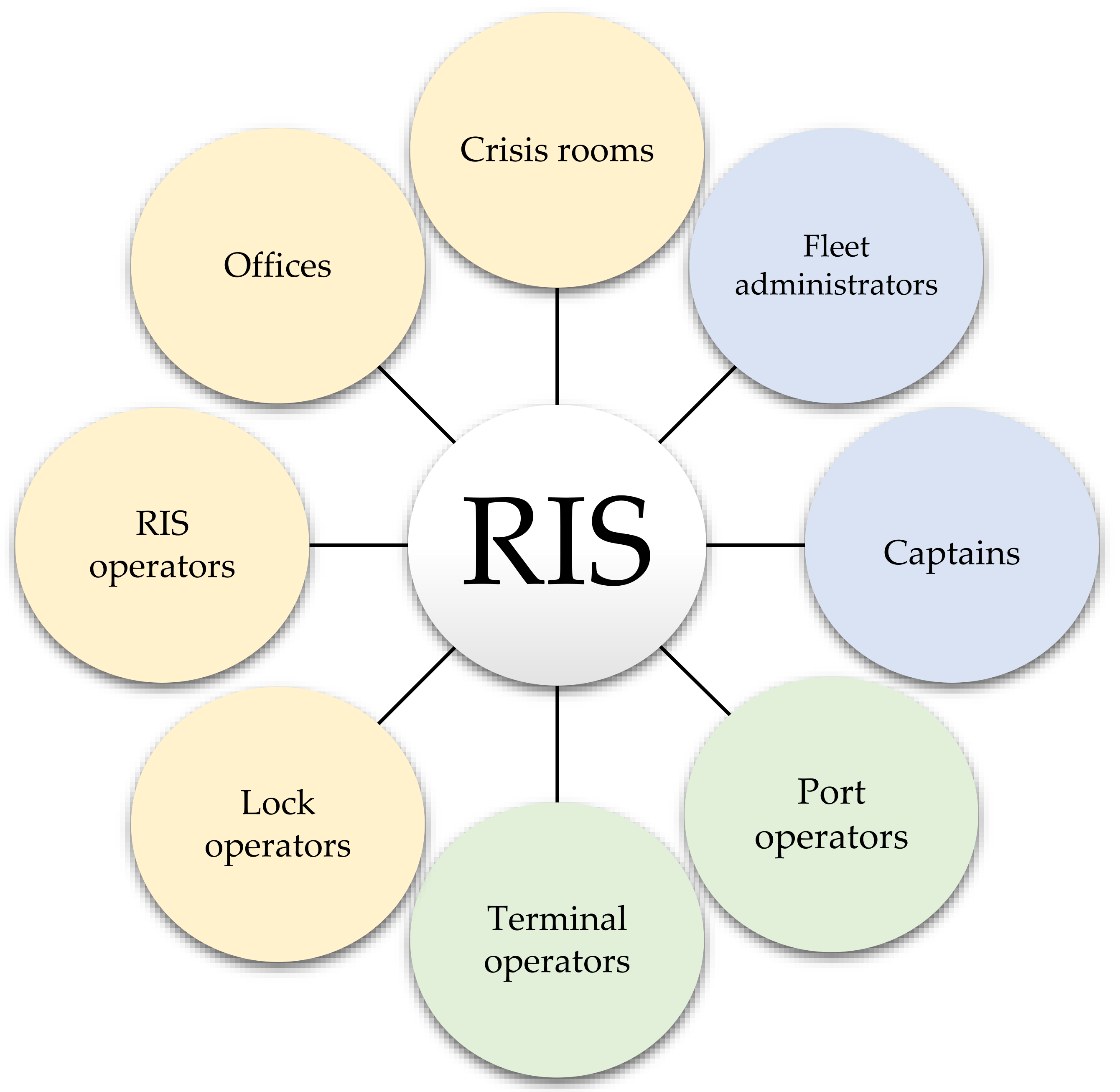
6. Possibility of Using the RIS System for Better Use of Inland Navigation in Urban Freight Transport

6.1. RIS System

Modern transport logistics management requires intensive information exchange between multiple partners and operators in the logistics chain. The use of the latest technologies of both data transmission and fleet or infrastructure management enables more efficient resource management and improves transport intermodality.
One of the key technologies that increase the attractiveness of water transport—enabling its fuller integration with other links in intermodal transport—are harmonized River Information Services, commonly called RIS. RIS is a tool for organizing and managing inland transport. It is a broadly understood service package, with various services aimed at optimizing traffic and transport flows. Thanks to this, it is possible to increase navigation safety and efficiency. RIS also modernizes the exchange of information between waterway administrators and users. RIS systems use common systems to connect pilots; transport companies; lock, port, and terminal operators; RIS operators; waterway administrators; and emergency services. They also allow better law enforcement, collection of statistical data, and facilitate the calculation of port and fairway fees [33].
The RIS system is regulated by the Directive 2005/44/EC of the European Parliament and of the Council of 7 September 2005 on harmonized river information services (RIS) on inland waterways in the Community, that obliges all member states to implement RIS on inland waterways of class IV and higher, which are connected to class IV waterways of other EU’s member states. Each EU member state is free to decide on the scope of implementation, meaning provided services, used technologies, and used equipment. However, all services have to be conforming to common European standards, to enable cross-border data exchange. Standards are developed by international groups of experts working on European level within European committee for drawing up standards in the field of inland navigation (Comité Européen pour l’Élaboration de Standards dans le Domaine de Navigation Intérieure—CESNI). There has also been formed an expert group within The World Association for Waterborne Transport Infrastructure, which once every few years, prepares recommendations form implementation of the RIS system [34,35]. In the year 2020, the European Commission evaluated previous implementation of the RIS system in the EU’s member states [36]. Countries with the most advanced implementation of RIS services are Austria, the Netherlands, Belgium, Germany, Hungary, and France.
The main advantage of the RIS system is the integration of various stakeholders in inland transport and easier, faster, and more complete exchange of information. As Beyer rightly points out, “Sharing information and building common platforms is therefore a key factor to the success of both the sharing of information in the standardized data exchange as it exists, for example, in the Cargo Community System or in strategic co-operation of institutional actors” [1].
RIS is an information system based on the harmonious interaction of three elements: devices, software, and operators. The link connecting all these elements is a communication system, both wired and wireless [37].
Thanks to this system, it is possible to increase navigation safety and efficiency. RIS also modernizes the exchange of information between waterway administrators and users. RIS systems use common systems to connect pilots; transport companies; lock, port, and terminal operators; RIS operators; waterway administrators; and emergency services. They also allow better law enforcement, collection of statistical data, and facilitate the calculation of port and fairway fees [38].
The yellow color in Figure 1 indicates state entities; blue color—private sector; and green color—entities which can be either state or private.
This information can be collected, processed, and sent to end users using a variety of tools and techniques, and can be used, inter alia, to:
  • enforce law,
  • collecting statistical data,
  • calculate port charges and charges for using the fairway,
  • manage fleet.

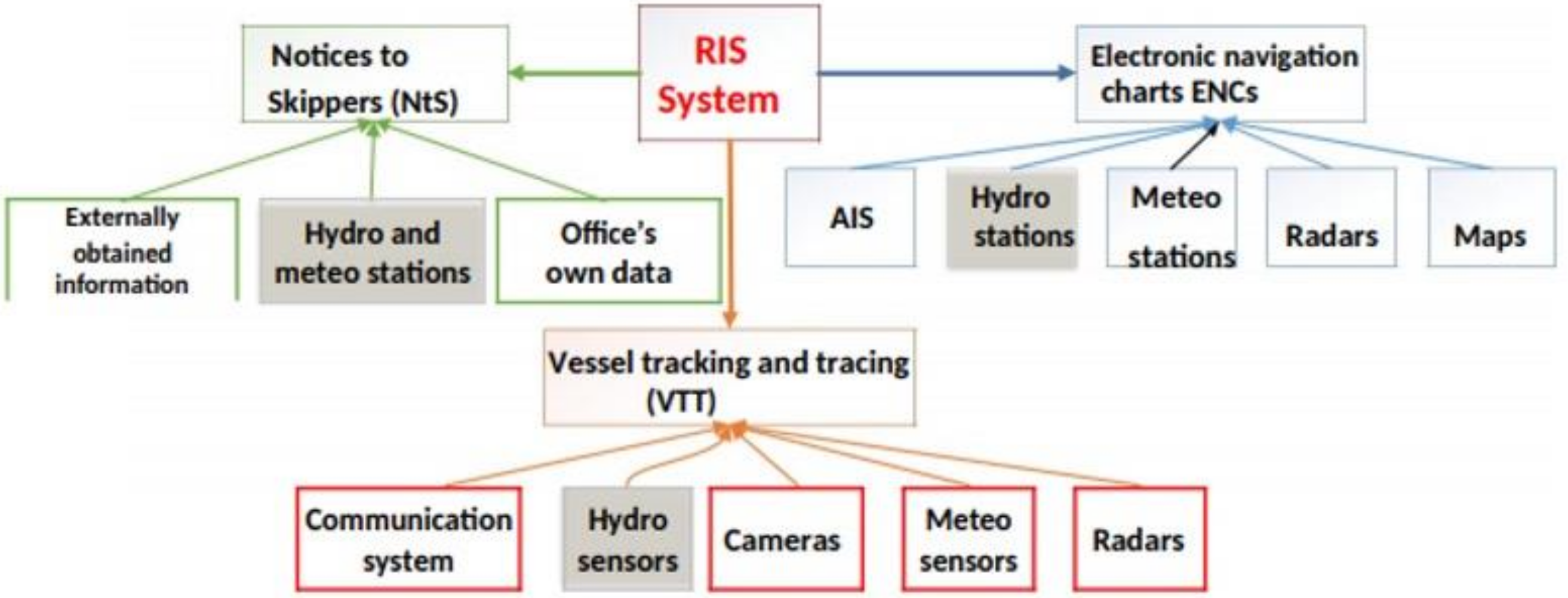
6.2. Services Provided by RIS

Four basic technologies are used to provide River Information Services:
  • Vessel Tracking and Tracing (VTT),
  • Notices to Skippers (NtS),
  • Electronic Ship Reporting (ERI),
  • Electronic Chart Display and Information System for Inland Navigation (Inland ECDIS).
Figure 2 below shows the diagram of the RIS system in Poland.

6.2.1. Ship Traffic Control System

Vessel Tracking and Tracing [VTT] makes it possible to supervise the safety of inland navigation, monitor water traffic and cooperate and provide information to relevant institutions and services. VTT can be implemented at three technology levels [37]:
  • presentation of the current traffic image based on AIS (automatic identification system for ships) data combined with an electronic navigation map and/or satellite images,
  • enriching the current traffic image with additional data to facilitate the analysis of the situation,
  • comprehensive image analysis of traffic flows and thus ship traffic management.
The basic components of the VTT system include:
  • automatic identification system for ships (AIS),
  • camera system,
  • VHF communication system,
  • electronic chart display and information system (ECDIS).
In addition, the system can be supplemented with a radar system and a GPS differentiation system. By design, technological solutions are only available to RIS centre operators.

6.2.2. Notices to Skippers (NtS)

Notices to Skippers (NtS) is information collected and transmitted by water and navigation administration about the shipping route and traffic flows, water levels, river ice/ice cap, and weather. The obligation to develop and distribute NtS derives from the RIS Directive, whose Article 4.3.d provides that Member States ensure that notices to skippers, including water level (or maximum allowable draught) and ice reports of their inland waterways, are provided as standardized, encoded, and downloadable messages. NtS usually consists of two modules:
  • an application enabling the preparation and publication of messages in accordance with standards developed by the International Group of RIS Experts,
  • an internet service for skippers/captains and stakeholders that allows you to download and view messages issued by the administration.

6.2.3. Electronic Ship Reporting

Electronic Ship Reporting in Inland Navigation (ERI) is a system that allows you to quickly send information entered by skippers. This information may relate to cargo, vessel, travel route, and crew personal data. Information obtained in this way can be used in various services.
An expert discussion on how to transfer information from the ship to public administration is currently under way in Europe. Two models are considered:
  • Introducing the obligation for the skipper/shipowner to report all required information before commencing the journey on a dedicated public administration platform in the country of commencement. In this model, international cooperation of water administrations is necessary in order to exchange information about planned cross-border travel, because the idea of ERI is that information should be entered into the system once and the institutions interested in it receive it in a timely manner. The greatest challenge for this information delivery model is the need for international exchange of sensitive data, which is often incompatible with local data protection laws (e.g., in Germany).
  • Entering data into the systems of each ship. In this case, the ship is a source of information that is forwarded to appropriate institutions using the technical infrastructure of the country. Each authorized institution may obtain only those from the available data pool which it needs (e.g., other data will be provided to the border guard and other data to the lock operator). This technical solution is at an early stage of development.

6.2.4. Electronic Navigation Charts

Inland Electronic Chart Display and Information System (Inland ECDIS) is an electronic navigation system dedicated to inland shipping. The bases of this technology are inland electronic navigational charts, which, supplemented with additional data—e.g., on the movement and position of the vessel—support the skipper’s decisions.
Electronic navigational charts are produced in accordance with standards adopted by European experts and contain information on navigation signs, navigation obstacles, available transit depth, etc. Additionally, data displayed on dedicated devices can also be integrated with information obtained from the AIS system (e.g., movement of other ships), NtS navigation messages, hydro-meteorological sensors, vessel’s GPS data. Currently, work is underway to increase the scope of information provided to the user (e.g., waterfront availability, additional terminal equipment, fees, etc.).

7. Improving the Efficiency of Urban Freight Transport Using the RIS System

RIS services described above provide waterway users with actual and specific information facilitating cargo transport in cities. Information and data may lead to a more efficient use of fleets (e.g., optimization of ship loading), infrastructure (e.g., water gates), and route planning, and make it possible for inland waterway transport to exist in certain conditions and be an alternative for other branches of transport, especially road transport [39,40]. A good example of use of data from RIS system is transportation of containers by waterways, since this form of unitization is gaining popularity. Performed analysis assumed shipment of two tiers of containers, using the most common fleet on Odra River waterway—two barges BP-500 and push-boat Bizon III. In Polish conditions one barge can hold up to 15 individual 40-feet containers stacked in two layers, so the whole set can carry up to 30 containers at once, thereby replacing 30 trucks when transporting containerized cargo. When transporting containers by inland waterways it is important to consider the average mass of a container, since it affects ship’s draft (the higher the mass, the deeper the draft). In turn, draft affects the minimal transit depth and required minimal clearance under the bridge. Ship’s draft may be additionally modified by using ballast waters.
To illustrate the topic and the usefulness of RIS tools in supporting container transport between urban centers, a comparative analysis of the time, cost, and carbon footprint of transporting 30 individual 40-feet containers weighing an average of 21,000 kg by road and inland waterway is carried out below. The route chosen for the analysis runs from Opole (Poland) to Wroclaw (Poland).
The example analyzed in Table 2 shows that transporting 30 individual 40-foot containers by inland waterway is a much more cost-effective and environmentally friendly solution, with the CO2 emissions being half that of road transport.
At the same time, however, it takes considerably longer to transport cargo on the analyzed route. However, it should be borne in mind that as the distance increases, the time differences will decrease due to the working time requirements of the truck driver. In this configuration, inland navigation is best suited for the transport of weather-resistant and non-perishable cargo. In addition, it should be considered that in Polish conditions the transport of goods by inland waterway is only possible at certain times. This is due to the fact that, for part of the year, the water levels and clearances under bridges are insufficient to allow navigation. The bottleneck on the analyzed route (Opole–Wroclaw) is the road bridge in Opole.
Below are shown the results of historical data analysis from Statistics Poland, on annual water conditions measured with authoritative water gauge in the limiting place for polish city of Opole. According to the ship’s specification, it has been assumed that the minimal transit depth should be 120 cm (push-boat’s draft, some ships may go through), and starting from the draft of 170 cm—which is the maximum draft of analyzed barge—all ships will go through. Table of the minimal transit depth can be found in Appendix A. Similarly, the possibility of going under the bridge based on the bridge clearance, was analyzed in the table in the Appendix A.
As the possibility to transport containers by inland waterway is dependent on navigational conditions (e.g., transit depths, bridge clearances), the use of modern information systems, such as RIS, provides supply chain operators with tools to accurately determine whether the transport of specific cargoes, with specific vessels, on specific routes is feasible at a given time. As depending on the average weight of the containers to be transported the draught of the vessel will change, which influences the required transit depth of the route and the minimum required clearance under bridges. Table A1 and Table A2 in the Appendix A show historical water level and clearance data under the Opole road bridge. In the study on container transport using the most common barge in Poland, the yellow color indicates cases where the use of RIS could contribute to the transport task (e.g., by optimizing the loading or using the vessel’s ballast system). Green means that each vessel of the analyzed type was able to fulfil the transport task and red means that transport was not possible. This tool can be used to analyze other waterways and other vessels after taking into account the relevant parameters for them.

8. Discussion

The research shown that in the taken annual navigational season on Odra River waterway (from March to October) probability of going under the road bridge in Opole is:
  • for barges with empty containers (av. weight of 1 container 2.25 tons)—63.5%
  • for barges with light containers (av. weight of 1 container 7.9 tons)—69.1%
  • for barges with medium containers (av. weight of 1 container 10.9 tons)—71.1%
  • for barges with heavy containers (av. weight of 1 container 13.8 tons)—72.6%
  • for barges with heaviest containers (av. weight of 1 container 24 tons)—68.7%
  • for barges with optimal containers (av. weight of 1 container 21 tons (Mass calculated by an algorithm elaborated by the author on the basis of historical data))—74.6%
Going under the road bridge in Opole is most likely (74.6%) for barges weighing the average of 21 tonnes. The research has shown that the greatest obstacle is the transit depth, which highly limits navigation. The use of RIS system for loading optimization may increase the probability of fulfilment of transport task by 11.1%.
The example analyzed shows that the RIS system can contribute to improving freight transport efficiency not only on longer routes, but also in urban conditions. Thanks to current information from the system, it is possible to:
  • Optimize ship’s loading—allowing to go through limiting place of any waterway, local shoal, or low-clearance bridge.
  • Optimize inter-branch transport—thanks to up-to-date information obtained both from the ship itself (e.g., from measuring sensors) and from RIS devices (e.g., shared image from cameras) and thanks to communication systems that enable continuous transmission of cargo travel data, it is possible to organize the cargo collection process more efficiently at the destination quay and its possible further transport to the destination using other means of transport (e.g., car, bicycle). This would minimize the need to wait for cargo at the pickup point and thus improve transport efficiency, including cost efficiency.
  • Optimize the cargo route—in some cities there are many alternative ways to get from A to B by waterways. Thanks to information from the RIS system, for example about the current clearance under bridges, the condition of quays (current or planned/anticipated), you can optimally plan cargo transport in urban agglomerations.
  • Optimize the use of fleet—thanks to up-to-date information about the transit depth, clearance under bridges, obstructions, or closures of individual sections of waterways and weather conditions (e.g., wind speed and direction) it is possible to fully use the fleet, especially in areas with difficult navigation conditions. Based on the information obtained from the devices and the RIS system, the shipowner or captain can decide how much cargo to take on board for safe transport. The more cargo the ship receives, the more profitable the transport, but the greater its draft. In shallow waters, the maximum permissible draft of a ship is often greater than the available transit depth, which is why it is important to choose the weight of the cargo properly so that it can be transported safely and that it remains profitable. On the other hand, on waterways with low clearances under bridges, but large transit depths, transport may only be possible with more loaded ships (the heavier the load, e.g., two layers of containers on board, the lower its height above the water level). In addition, fuel consumption can be optimized thanks to more precise travel planning. For example, when the captain receives information from the RIS system at what time it will be possible to pass through the lock, he/she can reduce the speed of the ship so as to arrive within the time limit and go through the lock without waiting. Speed reduction also means lower fuel consumption and thus lower transport costs.
  • Use technical infrastructure of waterways more efficiently—thanks to the optimization of ship travel time and the possibility to create a schedule for servicing a ship group, the efficiency of using point infrastructure—e.g., locks or charging points for electric ships—will increase.
  • Improve supervision and control of cargo transport—thanks to up-to-date information about the location of the cargo (thanks to the use of the AIS system with DGPS corrections with an accuracy of tens of centimeters), the sender and recipient can obtain very precise information about the current location of cargo, the speed at which it travels and estimated time of arrival. This will allow for better planning of further cargo handling, implementation of the just-in-time method, or more effective human resource management.
  • Combine many recipients/senders into one transport—thanks to up-to-date information about performed and planned transports, it is possible to create an exchange of water transport services in a given urban agglomeration. This will contribute to a more complete use of the fleet, more optimal planning of the delivery schedule (higher frequency of services), and thus a reduction in the cost of providing services.
  • Reduce administrative barriers—thanks to the automatic transmission of necessary data to competent state authorities and institutions (border guard, customs office, police, water and shipping authorities) as well as to administrators (public or private) of quays and terminals.
The feasibility of the proposed solution depends on the precision of the RIS equipment and the number of points where the measuring equipment is located. The higher the precision and density of RIS devices, the higher the reliability and accuracy of the data presented. Where devices are located at a considerable distance from each other, analytical tools for the estimation of navigation conditions are necessary. An additional challenge is to transmit this information directly to the skipper of the vessel, as the Internet is not available at every point along the waterway. Moreover, part of the RIS data is not publicly available, so there is no platform where the necessary RIS data are collected and made accessible. However, RIS is not fully suitable for predicting the waterway transit depth on waterways where the variability of the riverbed layout and morphology is considerable and may cause localized withdrawals.

9. Conclusions

Effective transport of people and goods is crucial for the functioning of the economy at both national and local levels. In cities, which are economic centers, insufficient transport infrastructure is becoming a growing problem. Despite significant expenditure on the development of road and rail infrastructure, the demand for transport services means that it is still insufficient [41]. The experience of recent years has shown that inland navigation can play an important role in urban logistics. The development of transport techniques means that inland transport can be used not only to transport bulk or containerized cargo, but also may also play an important role in transport on a smaller scale, in densely built-up urban areas. As many authors rightly point out [41], in order to meet the growing transport needs of the residents of city and metropolitan areas, a holistic approach is necessary, which will take into account all means of transport. Well-organized inland waterway transport—e.g., barges taking 100 TEU of cargo—is more effective than the daily use of hundreds of trucks which can get stuck in traffic jams [1]. Undoubted advantages of water transport include:
  • high transport capacity,
  • transport reliability—no congestion on waterways,
  • fuller use of existing infrastructure,
  • relieving road transport,
  • lower environmental impact than other transport modes,
  • the option of integration into integrated logistics solutions.
As the analysis has shown, inland navigation offers the possibility of transporting the same volume of cargo at considerably lower transport costs and the environmental benefits in terms of reduced carbon dioxide emissions from transport increase with the volume transported. However, the problem in this case is the transportation time, which on short routes is much longer than for road transport, and the state of the infrastructure, which prevents shipping at certain times of the year.
The use of the RIS system allows full integration of inland navigation with intermodal supply chains in urban agglomerations and better planning of urban freight transport. Accurate transport information can also optimize other transport activities. Other factors that enable urban distribution of water cargo include the use of special vessels and equipment as well as specific cargo units.
Numerous studies and research and implementation projects (e.g., Emma Extension) indicate that inland navigation can be an alternative to road transport in urban areas and contribute to improving the efficiency of urban freight transport. Waterways enable the creation of new space for cities through which:
  • increases capacity,
  • offers new communication paths,
  • changes the transport flow,
  • relieves the pressure from the current transport system.
The main limitation for research on the potential use of RIS-assisted inland waterway transport for urban and inter-urban cargo transport along rivers is the very poor condition of waterways in Poland. Most of them are unfit for commercial navigation, which results in a lack of data on the performance of waterways on many routes. Further research on this topic will focus on the capacity of the Oder Waterway, in particular the sections covered by RIS and the usability of individual RIS tools for different groups of waterway users. However, to fully utilize the potential of inland navigation, further development of transport technologies, ICT systems and means of transport dedicated to urban transport are necessary, in particular the consideration of weather conditions for the prediction of navigational conditions over a number of days.

Author Contributions

Conceptualization, P.D.; Methodology, N.D.; Resources, P.D.; Writing—original draft preparation, P.D. and N.D.; Writing—review and editing, N.D.; Supervision, P.D.; funding acquisition, P.D. All authors have read and agreed to the published version of the manuscript.

Funding

The research was funded by the Vice Rector for Science of the Maritime University of Szczecin, grant number 1/S/RB/21.

Institutional Review Board Statement

Not applicable.

Informed Consent Statement

Not applicable.

Data Availability Statement

The data presented in this study are available in: http://eurostat.europa.eu (accessed on 10 February 2021) and http://stat.gov.pl (accessed on 10 February 2021).

Conflicts of Interest

The authors declare no conflict of interest.

Appendix A

Table A1. Possibility of going under the road bridge in Opole between 2000 and 2015, considering minimal water depth.
Date2000200120022003200420052006200720082009201020112012201320142015
Jan
Feb
Mar
Apr
May
June
July
Aug
Sep
Oct
Nov
Dec
Legend
ColourValueDescription
>170 cmAll ships go through
120–170 cmSome ships go through
(depending on cargo weight)
<120 cmNo ship goes through
Source: own elaboration based on data from Statistics Poland.
Table A2. Possibility of going under the road bridge in Opole between 2000 and 2015, considering bridge clearance.
Data2000200120022003200420052006200720082009201020112012201320142015
Jan
Feb
Mar
Apr
May
June
July
Aug
Sep
Oct
Nov
Dec
Legend
ColourValueDescription
>500 cmAll ships go through
368–499 cmSome ships go through
(depending on cargo weight)
<368 cmNo ship goes through
Source: own elaboration based on data from Statistics Poland.

References

  1. Beyer, A. Inland Waterways, Transport Corridors and Urban Waterfronts. In International Transport. Forum Discussion Papers; OECD Publishing: Paris, France, 2018. [Google Scholar]
  2. Janjevic, M.; Ndiaye, A.B. Inland waterways transport for city logistics: A review of experiences and the role of local public authorities. Urban Transp. XX 2014, 138, 279–290. [Google Scholar]
  3. Available online: http://portofrotterdam.com (accessed on 13 October 2021).
  4. Muñoz-Villamizar, A.; Santos, J.; Montoya-Torres, J.; Velázquez-Martínez, J. Measuring environmental performance of urban freight transport systems: A case study. Sustain. Cities Soc. 2021, 52, 101844. [Google Scholar] [CrossRef]
  5. Silva, B.N.; Khan, M.; Han, K. Toward sustainable smart cities: A review of trends, architectures, components, and open challenges in smart cities. Sustain. Cities Soc. 2018, 38, 697–713. [Google Scholar] [CrossRef]
  6. Bibri, S.; Krogstie, J. Smart sustainable cities of the future: An extensive interdisciplinary literature review. Sustain. Cities Soc. 2017, 31, 183–212. [Google Scholar] [CrossRef]
  7. Holguín-Veras, J.; Leal, J.A.; Sánchez-Diaz, I.; Browne, M.; Wojtowicz, J. State of the Art and Practice of Urban Freight Management Part I: Infrastructure, Vehicle-Related, and Traffic Operations. Transp. Res. Part. A Policy Pract. 2020, 37, 360–382. [Google Scholar] [CrossRef]
  8. Kin, B.; Verlinde, S.; Macharis, C. Sustainable urban freight transport in megacities in emerging markets. Sustain. Cities Soc. 2017, 32, 31–42. [Google Scholar] [CrossRef]
  9. Melkonan, A.; Koch, J.; Lohmar, F.; Kamath, V.; Munteanu, V.; Schmidt, J.; Bleischwitz, R. Integrated urban mobility policies in metropolitan areas. A system dynamics approach for the Rhine-Ruhr metropolitan region in Germany. Sustain. Cities Soc. 2020, 61, 102358. [Google Scholar] [CrossRef]
  10. Taniguchi, E.; Thompson, R.; Yamada, T. Recent Trends and Innovations in Modelling City Logistics. Procedia—Soc. Behav. Sci. 2014, 125, 4–14. [Google Scholar] [CrossRef] [Green Version]
  11. Al Enezy, O.; van Hassel, E.; Sys, C.H.; Vanelslander, T. Developing a cost calculation model for inland navigation. Res. Transp. Bus. Manag. 2017, 23, 64–74. [Google Scholar] [CrossRef]
  12. Comi, A.; Nuzzolo, A. Simulating Urban Freight Flows with Combined Shopping and Restocking Demand Models. Procedia—Soc. Behav. Sci. 2014, 125, 49–61. [Google Scholar] [CrossRef]
  13. Wojewódzka-Król, K.; Rolbecki, R. The Role of Inland Waterway Transport in City Logistics. Transport. Econ. Logist. 2019, 84, 103–114. [Google Scholar] [CrossRef]
  14. Caris, A.; Macharis, C.; Janssens, G.K. Network analysis of container barge transport in the port of Antwerp by means of simulation. J. Transport. Geogr. 2011, 19, 125–133. [Google Scholar] [CrossRef] [Green Version]
  15. Konings, R. Opportunities to improve container barge handling in the port of Rotterdam from a transport network perspective. J. Transport. Geogr. 2007, 15, 443–454. [Google Scholar] [CrossRef]
  16. Semenov, I.; Kaup, M.; Ignalewski, W.; Durajczyk, P. Metody ograniczania emisji substancji gazowych i pyłowych na statkach śródlądowych. Probl. Transp. I Logistyki 2018, 44, 85–94. [Google Scholar]
  17. Douma, A.M.; van Hillegersberg, J.; Schuur, P.C. Design and evaluation of a simulation game to introduce a Multi-Agent system for barge handling in a seaport. Decis. Support. Syst. 2012, 53, 465–472. [Google Scholar] [CrossRef] [Green Version]
  18. Kulczyk, J.; Winter, J. Śródlądowy Transport Wodny, 1st ed.; Oficyna Wydawnicza Politechniki Wrocławskiej: Wroclaw, Poland, 2013. [Google Scholar]
  19. Woś, K. Kierunki Aktywizacji Działalności Żeglugi Śródlądowej W Rejonie Ujścia Odry W Warunkach Integracji Polski Z Unią Europejską, 1st ed.; Oficyna Wydawnicza “Sadyba”: Warsaw, Poland, 2005. [Google Scholar]
  20. Żylicz, A. Statki Sródlądowe, 1st ed.; Wydawnictwo Morskie Gdańsk: Gdańsk, Poland, 1979. [Google Scholar]
  21. Jacyna, M. System Logistyczny Polski. In Uwarunkowania Techniczno-Technologiczne Komodalności Transportu, 1st ed.; Oficyna Wydawnicza Politechniki Warszawskiej: Warsaw, Poland, 2012. [Google Scholar]
  22. Mindur, L. Technologie Transportowe, 1st ed.; Wydawnictwo Naukowe Instytutu Technologii Eksploatacji—PIB: Radom, Poland, 2014. [Google Scholar]
  23. Rosa, G. Konkurencja na Rynku Usług Transportowych, 1st ed.; Wydawnictwo C.H. Beck: Warsaw, Poland, 2013. [Google Scholar]
  24. Wojewódzka-Król, K.; Rolbiecki, R. Polityka Rozwoju Transportu, 1st ed.; Wydawnictwo Uniwersytetu Gdańskiego: Gdańsk, Poland, 2012. [Google Scholar]
  25. Konings, R.; Kreutzberger, E.; Maraš, V. Major considerations in developing a hub-and-spoke network to improve the cost performance of container barge transport in the hinterland: The case of the port of Rotterdam. J. Transport. Geogr. 2013, 29, 63–73. [Google Scholar] [CrossRef]
  26. Bergqvist, R.; Macharis, C.; Meers, D.; Woxenius, J. Making hinterland transport more sustainable a multi actor multi criteria analysis. Res. Transp. Bus. Manag. 2015, 14, 80–89. [Google Scholar] [CrossRef]
  27. Kotowska, I.; Mańkowska, M.; Pluciński, M. Inland Shipping to Serve the Hinterland: The Challenge for Seaport Authorities. Sustainability 2018, 8, 3468. [Google Scholar] [CrossRef] [Green Version]
  28. European Commission. Roadmap to a Single European Transport Area—Towards a Competitive and Resource Efficient Transport System. White Paper 2011. Available online: https://ec.europa.eu/transport/themes/strategies/2011white_paper_en (accessed on 21 May 2021).
  29. European Commission. Assessment of Potential of Maritime and Inland Ports and Inland Waterways and of Related Policy Measures, Including Industrial Policy Measures. Final Report; Publications Office of the European Union: Luxembourg, 2020. [Google Scholar]
  30. European Commission. Directive 2005/44/EC on Harmonised River Information Services (RIS) on Inland Waterways in the Community; Publications Office of the European Union: Luxembourg, 2005. [Google Scholar]
  31. European Commission, Commission Staff Working Document Evaluation of the Directive 2005/44/EC on Harmonised River Information Services. 2021. Available online: https://eur-lex.europa.eu/legal-content/EN/TXT/?uri=SWD%3A2021%3A50%3AFIN (accessed on 13 October 2021).
  32. Niedzielski, P.; Durajczyk, P.; Drop, N. Utilizing the RIS system to improve the efficiency of inland waterway transport companies. Procedia Comput. Sci. 2021, 192, 4853–4864. [Google Scholar] [CrossRef]
  33. Durajczyk, P. The Analysis of the Possibility to Improve the Efficiency of Container Transport Via the Oder Waterway with the Use of the RIS System. NAŠE MORE Znan. Časopis Za More I pomorstvo 2020, 67, 199–208. [Google Scholar] [CrossRef]
  34. PIANC International Navigation Association (2019a). InCom WG Report n° 125/I—2019 Guidelines and Recommendations for River Information Services; PIANC: Brussels, Belgium, 2019. [Google Scholar]
  35. PIANC International Navigation Association (2019b). InCom WG Report n° 125/II—2019 Technical Report on the Status of River Information Services; PIANC: Brussels, Belgium, 2019. [Google Scholar]
  36. European Commission. Study Supporting the Evaluation of Directive 2005/44/EC on Harmonised River Information Services (RIS); Publications Office of the European Union: Luxembourg, 2020. [Google Scholar]
  37. Durajczyk, P. Korzyści z wdrożenia systemu informacji rzecznej RIS. Logistyka 2014, 6, 13241. [Google Scholar]
  38. Durajczyk, P. Międzynarodowa współpraca przy wdrażaniu usług RIS w Europie na przykładzie projektu IRIS Europe. Logistyka 2011, 6, 4647. [Google Scholar]
  39. PIANC International Navigation Association. Guildelines and Recommendations for River Information Services, 2nd ed.; PIANC: Brussels, Belgium, 2004. [Google Scholar]
  40. European Commission, Digital Inland Waterway Area towards a Digital Inland Waterway Area and Digital Multimodal Nodes. Available online: https://ec.europa.eu/transport/sites/transport/files/studies/2017–10-dina.pdf (accessed on 10 February 2021).
  41. Steniusl, I.; Garmel, K.; Hall Kihl, S.; Burman, M. Waterway 365. System Analysis of Challenges in Increased Urban Mobility by Utilization of the Water Ways; KTH Royal Institute of Technology: Stockholm, Sweden, 2014. [Google Scholar]
Figure 1. RIS users. Source: Own elaboration
Energies 14 07086 g001
Figure 2. RIS system diagram. Source: Own elaboration
Energies 14 07086 g002
Table 1. Examples of the use of inland navigation in urban logistics
ProjectsStart YearEstimated Impact on the Environment
Beer Boat
(Utrecht): delivery to local shops, hotels, and restaurants.Since 1996, the city has been using Beer Boat to provide drinks and food for over 70 dining outlets along the Utrecht canals
1996In the first stage (in 1996–2010) using a diesel ship, reduction of emissions:
  • particles by 74%,
  • CO2 by 27%,
  • NOx by 85%;
In the second stage (after 2010) using an electric ship to reduce emissions:
  • particles by 98%,
  • CO2 by 94%,
  • NOx by 100%.
Vert Chez Vous
(Paris): parcel delivery
Delivery service using two alternative methods of urban distribution of packages weighing less than 30 kg
2012Can:
  • reduce the number of heavy cars traveling on city roads by 15
  • reduce CO2 emissions by 207.9 kg each day, i.e., 51,975 kg per year
Floating DHL
(Amsterdam): parcel delivery
Distribution center in the form of a specially constructed boat that goes through the canals of Amsterdam, from where bicycle couriers collect parcels and deliver to recipients
1997Can:
  • reduce the number of heavy cars traveling on city roads by 10 every day
  • reduce the number of kilometres covered by trucks by 150,000,
  • consume 12,000 litres less diesel fuel per year
Franprix
(Paris): food delivery
Daily transport and delivery of food products to 80 stores in the centre of Paris via waterways
2012Can:
  • reduce the distance covered by trucks by 450,000 km.
  • 37% reduction in CO2 emissions throughout the entire supply chain
POINT-P
(Paris): transport of palletized building materials
1987Can:
  • avoid overland travel of 2000 trucks a year
  • reduce CO2 emissions by 220 tonnes per year
Paper recycling
(Paris): a barge equipped with a deck crane for handling cargo.
Shipment of collected old newspapers and magazines for recycling to Grand-Couronne (Rouen) and returning newly produced paper rolls by ship
2005Can:
  • avoid travel of 4500 trucks a year
  • reduce fossil energy consumption and CO2 emissions by 40%
Source: Own elaboration based on [2].
Table 2. Comparison of time, costs and carbon dioxide emissions of transporting 30 individual 40-foot containers by inland waterway and by road between Opole and Wrocław.
Inland NavigationRoad Transport
Distance153 km100.6 km
Average speedDownstream 25 km/h
Upstream 10 km/h
55 km/h
Travel timeDownstream 6 h 8 min
Upstream 15 h 18 min
1 h 50 min
Fuel consumption per 100 km300 L38 L
Fuel consumption en route459 L41.8 L
CO2 emissions per 1 L of fuel3.15 kg2.35 kg
CO2 emissions en route1445.85 kg2946.90 kg
Cost of transport1404.30 euro4768.44 euro
Source: own elaboration.
Publisher’s Note: MDPI stays neutral with regard to jurisdictional claims in published maps and institutional affiliations.

