Article

Reservoir Formation Model and Main Controlling Factors of the Carboniferous Volcanic Reservoir in the Hong-Che Fault Zone, Junggar Basin

1
School of Geophysics and Information Technology, China University of Geosciences, Beijing 100083, China
2
School of Energy Resources, China University of Geosciences, Beijing 100083, China
*
Author to whom correspondence should be addressed.
Energies 2020, 13(22), 6114; https://doi.org/10.3390/en13226114
Submission received: 12 October 2020 / Revised: 13 November 2020 / Accepted: 16 November 2020 / Published: 21 November 2020
(This article belongs to the Special Issue Development of Unconventional Reservoirs 2020)

Abstract

:
The Hong-Che Fault Zone is one of the important oil and gas enrichment zones in the Junggar Basin, especially in the Carboniferous. In recent five years, it has been proven that the Carboniferous volcanic rock has 140 million tons of oil reserves, and has built the Carboniferous volcanic reservoir with a capacity of million tons. Practice has proven that the volcanic rocks in this area have great potential for oil and gas exploration and development. To date, Carboniferous volcanic reservoirs have been discovered in well areas such as Che 32, Che 47, Che 91, Chefeng 3, Che 210, and Che 471. The study of drilling, logging, and seismic data shows that the Carboniferous volcanic reservoirs in the Hong-Che Fault Zone are mainly distributed in the hanging wall of the fault zone, and oil and gas have mainly accumulated in the high part of the structure. The reservoirs are controlled by faults and lithofacies in the plane and are vertically distributed within 400 m from the top of the Carboniferous. The Carboniferous of the Hong-Che Fault Zone has experienced weathering leaching and has developed a weathering crust. The vertical zonation characteristics of the weathering crust at the top of the Carboniferous in the area of the Che 210 well are obvious. The soil layer, leached zone, disintegration zone, and parent rock developed from top to bottom. Among these reservoirs, the reservoirs with the best physical properties are mainly developed in the leached zone. Based on a comprehensive analysis of the Carboniferous oil and gas reservoirs in areas of the Chefeng 3 and Che 210 wells, it is believed that the formation of volcanic reservoirs in the Hong-Che Fault Zone was mainly controlled by structures and was also controlled by lithofacies, unconformity surfaces, and physical properties.

Graphical Abstract

1. Introduction

Volcanic reservoirs are widely distributed in more than 300 basins or blocks in over 20 countries and five continents and are becoming an important new area for global oil and gas resource exploration and development [1,2,3,4,5] (Table 1).
According to the characteristics of volcanic oil and gas reservoirs, which have already been discovered around the world, these strata have strong epochal and regional characteristics and mainly include Archean, Carboniferous, Permian, Cretaceous, and Paleogene strata. In addition, they are mainly distributed in the circum-Pacific, Mediterranean and Central Asian regions [6]. The circum-Pacific region is the main area of distribution of volcanic oil and gas reservoirs, which includes the United States, Mexico, and Cuba in North America; Venezuela, Brazil, and Argentina in South America; and China, Japan, and Indonesia in Asia. These areas are followed in importance by the Mediterranean region and Central Asia. Some volcanic oil and gas reservoirs have also been found on the African continent, such as in Egypt, Libya, Morocco in North Africa and Angola in South Africa [7].
At present, volcanic reservoirs have been found in 14 sedimentary basins in China (Table 2) [8]. There are three main sets of volcanic strata that developed in the sedimentary basins of China: Carboniferous-Permian, Jurassic-Cretaceous, and Paleogene-Neogene [7]. In terms of spatial locations, the volcanic reservoirs in China can be divided into two parts: Eastern part and western part. The volcanic rocks in eastern China (such as the Bohai Bay Basin) mainly developed in rifted basins, which were controlled by an intracontinental rift environment that was caused by subduction of the Pacific plate under the Chinese mainland since the Mesozoic and Cenozoic [9,10,11]. The development of volcanic rocks in the western basins, as represented by the Junggar Basin, was closely related to the formation and closure of the Paleo-Asian and Paleo-Tethys Oceans and the orogeny that was induced by them [12,13,14].
Since the first discovery of volcanic reservoirs in the San Joaquin Basin, California, USA in 1887, more than 300 volcanic-related reservoirs or oil-gas occurrences have been discovered worldwide [2,7]. The research and understanding of volcanic oil and gas exploration can be categorized into three stages: Accidental discovery stage, local exploration stage, and comprehensive exploration stage. Up to now, extensive volcanic reservoir exploration has been conducted worldwide, and many volcanic reservoirs have been discovered. Volcanic rocks have changed from being an initial “forbidden zone” for oil and gas exploration to a “target zone”. Volcanic reservoirs in the sedimentary basins of China were first discovered in the northwestern margin of the Junggar Basin in 1957. At present, the exploration and development of volcanic reservoirs in the sedimentary basins of China is being comprehensively carried out, and great progress and breakthroughs have been made.
From a global perspective, nearly all types of igneous rocks, from basic rocks to acidic rocks and from lava to pyroclastic rocks, may have the potential to form effective reservoirs. Compared with conventional reservoirs, the formation of volcanic rock storage conditions is more random, which requires specific analysis based on the actual geology of specific regions [5]. At present, the proven oil and gas reserves in volcanic rocks account for only approximately 1% of the total proven global oil and gas reserves but have great exploration potential [4].
The Junggar Basin is a large-scale composite superimposed basin, which has undergone a complex tectonic evolution process. In the Late Carboniferous to Early Permian, the Paleo-Asian Ocean was completely closed, and the northern Xinjiang was in a post-collisional extensional environment. Large-scale mantle-derived magmatism took place in northern Xinjiang, which included the Junggar region. Volcanic rocks were widely distributed on the uplift structures of the basin [15]. Volcanic rocks in the high parts of structures have undergone long-term weathering, leaching, and dissolution, as well as transformations caused by later tectonic activities, have developed rich secondary pores and fractures, and have become high-quality reservoirs. During the process of oil and gas exploration that has extended to the deep layers of the basin, Carboniferous volcanic rocks have become an important new exploration target. The volcanic eruptions in the Junggar basin are mainly transitional facies between sea and land, with multiple eruptions, mostly small volcanoes, and the complexity of volcanic lithology increases. Most of the volcanic eruptions in foreign countries are marine facies, erupting on the seabed, and the scale of volcanoes is large.
The Hong-Che Fault Zone is located at the southern end of a fault system at the northwestern margin of the Junggar Basin. It is one of the long-term direction areas for oil and gas migration and is rich in oil and gas resources. The Carboniferous in the Hong-Che Fault Zone is an important hydrocarbon enrichment zone in the northwestern margin where various types of oil and gas reservoirs have developed, which have reserves of considerable scale and excellent exploration potential. The distribution system of faults in the Hong-Che Fault Zone is complex, and the lithology and lithofacies of the Carboniferous volcanic rocks are heterogeneous. The distribution of volcanic reservoirs is affected by lithology, and the whole region is oil-bearing but is locally enriched, and the differences are relatively large. At present, there is a lack of systematic research on the formation of volcanic reservoirs in this area, and the distribution laws of oil and gas and the main controlling factors for hydrocarbon accumulations are not clear. Therefore, it is necessary to summarize the characteristics, reservoir forming mechanisms, and main controlling factors of volcanic reservoirs, which is of great practical significance for predicting favorable volcanic reservoir zones and effectively developing volcanic reservoirs in this area. This knowledge can also provide a theoretical basis for the next exploration and development of Carboniferous volcanic rock-based oil and gas in the Junggar Basin.

2. Geological Setting

The northwestern marginal fault system of the Junggar Basin is located in the middle of the Central Asian Orogenic Belt (CAOB) (Figure 1), which is in the coupling region between the Junggar Basin and West Junggar Block. Its formation and evolution were mainly affected by the activity of the West Junggar Orogenic Belt to the west [16]. From north to south, it is divided into the Wu-Xia, Ke-Bai, and Hong-Che Fault Zones [17,18,19,20]. The Hong-Che Fault Zone is located at the southern end of the fault system, which is located at the northwestern margin of the Junggar Basin (Figure 1). It strikes nearly north-south and has a length of approximately 80 km and width of approximately 10–20 km. It is adjacent to the Ke-Bai Fault Zone to the north, Chepaizi Uplift to the west, Sikeshu Depression to the south, and the Zhongguai Uplift and Shawan Depression to the east and extends over an area of approximately 1500 km2 [21,22].
Studies have shown that the West Junggar region was in a post orogenic extensional environment during the Late Carboniferous to Early Permian [24,25,26,27]. The Late Carboniferous-Early Permian volcanic rocks in the West Junggar area and surrounding areas are mainly basalts and rhyolites with less neutral components, which form a typical “bimodal” series. A-type granites are well developed. This tectonic rock association and geochemical characteristics indicate that they formed in an extensional environment of crustal thinning. It is comprehensively judged that the study area has a post orogenic extensional background. During this period, the basin was mainly composed of grabens and half grabens, which were controlled by normal faults with a dual structure of “lower faults and upper depressions” [16,27]. Since the Permian, it has experienced five tectonic stages: Early Permian post orogenic extension, strong Middle-Late Permian compression and thrusting, inherited Triassic thrust superimposition, overall Jurassic-Cretaceous oscillation, and Cenozoic intracontinental foreland [16,28].
According to the drilling and seismic data, the Carboniferous, Permian, Triassic, Jurassic, Cretaceous, Paleogene, Neogene, and Quaternary all developed from bottom to top in the study area (Figure 2). The Lower Permian Jiamuhe Formation (P1j), Fengcheng Formation (P1f), Middle Permian Xiazijie Formation (P2x), Lower Wuerhe Formation (P2w), and Upper Permian Upper Wuerhe Formation (P3w) developed from bottom to top. The Baikouquan Formation (T1b), Karamay Formation (T2k), and Baijiantan Formation (T3b) developed from bottom to top in the Triassic. The Jurassic mainly includes the Badaowan Formation (J1b), Sangonghe Formation (J1s), Xishanyao Formation (J2x), Toutunhe Formation (J2t), and Qigu Formation (J3q). The Tugulu Group (K1tg) developed in the Cretaceous. Since the study area has been located at a high position of structures from the Permian to the end of the Jurassic and has been in a state of continuous uplift for a long period, the Permian and Triassic are missing in most areas of the fault zone. From east to west, the Jurassic and Cretaceous overlapped and were deposited on top of the Carboniferous bedrock. Due to the influence of the late Hercynian, Indosinian, Yanshanian, and Himalayan movements, the unconformity surfaces of the lower boundaries of the Upper Wuerhe Formation (P3w), Jurassic, Cretaceous, and Neogene are developed in the study area.

3. Data and Methods

The research data includes three-dimensional seismic data of the Hong-Che Fault Zone, well logging, core and casting thin section data of exploration wells. The target layer of study is the Carboniferous volcanic rocks. Through the interpretation of seismic data, we analyze the structural characteristics of the reservoir. Based on the analysis of typical oil and gas reservoirs in the Chefeng 3 and Che 210 well blocks, the main controlling factors and hydrocarbon accumulation model of Carboniferous volcanic rocks in the Hong-Che Fault Zone are obtained.

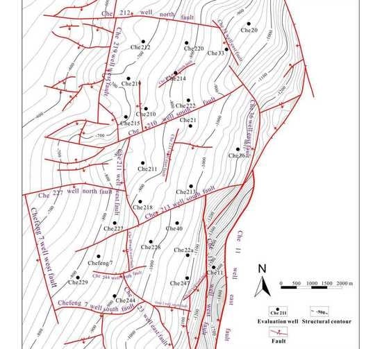
3.1. Structural characteristics

During the Middle-Late Permian, a strong compressional orogenic activity occurred in the western mountains of the Junggar Basin and the Hong-Che Fault Zone was characterized by a large-scale thrust nappe due to compression. The structural type of the Hong-Che Fault Zone mainly consists of a thrust nappe structure. This fault zone is generally characterized by the development of multiple N-S thrust faults and fault terrace belts uplifted from east to west [30,31]. The fault combination is mainly an imbricate thrust fault combination (Figure 3).
The strike direction of the thrust fault is nearly north-south and its dip is westward. The dip angle of the upper part is 50–70° and the dip angle of the lower part is 20–30° [17]. The fault strata date is from the Carboniferous to the upper Jurassic boundary. The Hongche Fault has a variable strike and extends approximately 120 km in an arc shape along the plane and can be divided into three sections: South, middle, and north. Among them, the north section tends to trend NNE, the middle section trends nearly NS, and the south section trends NW [23].

3.2. Characteristics of Volcanic Reservoirs

Drilling has shown that the Carboniferous lithology of Hong-Che Fault Zone is dominated by igneous rocks with small amounts of sedimentary rocks [32]. Igneous rocks can be divided into igneous extrusive rocks and igneous intrusive rocks depending on the type of volcanism. Based on the volcanism products, the Carboniferous igneous rocks in the study area can be divided into five types: Volcanic lava, pyroclastic lava, pyroclastic rock, sedimentary pyroclastic rock, and pyroclastic sedimentary rock (Table 3). The volcanic lavas include basalt and andesite and pyroclastic rocks include tuff and volcanic breccia.
Liu (2013) collected thin section data for 404 sample points from 36 wells of the Carboniferous in the Hong-Che Fault Zone and constructed a Carboniferous lithology statistical map (Figure 4) [32]. It can be seen from Figure 4 that igneous rocks mainly developed in this area, the percentage of normal sedimentary rocks is below 10%, and intrusive rocks rarely developed. Among the igneous rocks, pyroclastic rocks and volcanic lavas are most developed, which account for 42% and 26%, respectively, and are followed by pyroclastic sedimentary rocks, which account for 12%.
The Carboniferous volcanic rocks in the Hong-Che Fault Zone are characterized by multiple stages and intermittent eruptions. There were at least three eruption periods in the Carboniferous and there were multiple eruption cycles in each eruption period. The lithofacies distributions of each eruption period exhibit both similarities and differences [29,32]. The lithofacies of the Carboniferous volcanic rocks gradually changed from volcanic eruptive facies to overflow facies to volcanic sedimentary facies and later to pyroclastic facies (Figure 5). Carboniferous volcanic eruptions mainly occurred along the Hongche Fault, Guaiqian Fault, and other large-scale boundary faults, such as the Che 47, Che 43, Che 46, and Che 72 well volcanic eruption centers. The volcanic eruptions occurred along the faults and were linear fissure eruptions [33].
Oil testing and well logging interpretation data show that the lithofacies of the Carboniferous reservoirs in the Hong-Che Fault Zone are mainly eruptive facies, overflow facies, clastic sedimentary facies, and volcanic sedimentary facies. Among the 46 reservoir samples collected, eruptive facies account for 39.1% and are followed by clastic sedimentary facies, which account for 28.3%. The reservoir samples that developed in the overflow facies account for 23.9% and a small amount (8.7%) developed in volcanic sedimentary facies (Figure 6).
Through core analyses of the volcanic rocks, the relationship between volcanic lithofacies and porosity and permeability parameters was obtained (Table 4) [29,32]. The porosity and permeability of each lithofacies are quite different. The physical properties of the eruptive and clastic sedimentary facies are most favorable, while those of the volcanic sedimentary facies are least favorable.
The reservoir spaces of the Carboniferous reservoirs in the Hong-Che Fault Zone have dual pore media, which include pores and fractures. The primary pores are generally not developed in the Carboniferous and are mainly secondary pores, which include intragranular dissolved pores, intragranular intercrystalline pores, zeolite dissolution pores, and residual intergranular pores, as well as other dissolved pores [34]. There are various types of fractures with complex characteristics in the Carboniferous volcanic reservoirs in the Hong-Che Fault Zone, which include structural fractures, diagenetic fractures, dissolution fractures, and induced fractures. Among these fracture types, structural fractures are the main fracture types. The structural fractures of the Carboniferous volcanic rocks mainly consist of oblique and reticular fractures (Figure 7). The fracture tendency is disorderly and the strikes are NNW and NNE. After the formation of Carboniferous volcanic rocks, the Hong-Che Fault Zone experienced four major tectonic activities, which correspond to the four stages of fracture formation. Vertically, the Carboniferous volcanic rock fractures are widely developed from the top of the Carboniferous downward to a depth of approximately 250 m but the fractures rarely developed below depths of 250 m and are only found in individual wells [35,36].
Taking the Che 210 well block as an example, based on core observations and casting thin section data analysis, the pore types of the Carboniferous reservoirs in this area are mainly dissolution pores and micro-fracture pores. By microscopic analysis, the core at 1180.55 m in the Che 222 well consists of tuffaceous fine sandstone with intragranular dissolved pores, which account for 50% of the total pores and micro-fractures, which also account for 50%. There is fine-grained sandstone at 1334.08 m in the Che 222 well and intragranular dissolved pores account for 100% of the total pores (Figure 8).
According to the analysis of casting thin section data, the tuffaceous sandstone in the area of the Che 210 well mainly developed dissolution pores, which are dominated by intragranular dissolved pores, matrix dissolved pores, and micro-fractures. Volcanic breccias mainly developed dissolution pores and microfractures, tuff mainly developed fractures, and basaltic andesite mainly developed dissolution pores dominated by phenocryst-dissolved pores (Figure 9).

3.3. Reservoir Characteristics and Types

The Carboniferous reverse faults in the Hong-Che Fault Zone are developed and can be divided into two groups: One group is a nearly north-south trending fault system, which extends farther in the plane direction and is the main fault of the Hong-Che Fault Zone. The other group is nearly an EW trending fault system with short plane extensions and small fault distances. The two groups of faults cut each other to form a fault block group, which formed a series of fault block traps such as the Che 23 well, Che 210 well, Che 91 well, and Che Feng 6 well. The Hong-Che Fault Zone has a variety of favorable fault block traps of different sizes and there are many oil and gas producing locations, which easily formed fault block oil and gas reservoirs. Along the plane, they are mainly distributed along the fault zone in strips and along the profile, they are mainly distributed in the ascending wall of the Hong-Che Fault Zone but there are also some favorable traps in the footwall. The main types of traps are fault block and fault-lithology. The Carboniferous in the Hong-Che Fault Zone mainly developed fault block reservoirs, lithologic reservoirs, and fault-lithologic reservoirs [37].
Taking the reservoir of the Chefeng 3 well block as an example, the Carboniferous fault block in this area can be divided into three secondary structures: The Che 91 well fault block, Che 63 well west fault block, and Che 24 well fault block. It is believed that this area is controlled by fault blocks.
The Carboniferous reservoir in the area of the Che 91 well consists mainly of volcanic rock and its lithology is mostly volcanic breccia, basalt, andesite, and tuff. The physical properties of the explosive facies breccia are most favorable and are followed by broken basalt, andesite, and tuff, which are least favorable. This reservoir is a pore-fracture dual-medium reservoir. Due to the strong tectonic activity, the fractures in the study area are relatively well-developed and are mainly structural fractures, which more effectively change the physical properties of igneous reservoirs in this section.
The reservoir type of the Carboniferous in the area of the Chefeng 3 well is a fault block reservoir, which is controlled by volcanic lithofacies (Figure 10). The reservoir is controlled by faults and volcanic lithofacies along the plane and is controlled by ancient volcanic eruption sequences in the vertical direction. The reservoir lithology is mainly composed of volcanic breccia from eruptive facies, broken basalts of overflow facies, and the upper sedimentary tuff is a good caprock.
Taking the Che 210 well area as an example, two groups of reverse faults developed mainly in the Carboniferous. One group is a near east-west fault with a short plane extension distance, such as Che 212 well north fault, Che 210 well south fault, Che 213 well south fault, and Guai 2 well south fault. There is a group of nearly north-south trending faults with long plane extension distances, such as the Che 36 well east fault, Che 211 well west fault, and Che 11 well west fault, which control the stratigraphic distribution of the Hong-Che Fault Zone and gradually rise from east to west and have resulted in serious denudation of the strata. The two groups of faults cut each other to form multiple fault block traps. The Carboniferous reservoir in the area of the Che 210 well developed in four fault block traps, which are Che 210 well, Che 211 well, Chefeng 7 well, and Che 228 well block trap (Figure 11).
According to a statistical analysis of thin section identifications and core observation data, three types of reservoirs developed in the Carboniferous strata in the area of the Che 210 well: Tuffaceous sandstone, tuff and volcanic breccia, and basaltic andesite in overflow facies (Figure 12). Among them, tuffaceous sandstone is widely distributed in this area and forms the main reservoir, which is followed by tuff and volcanic breccia, while basaltic andesite is less commonly distributed. These properties can be seen in the oil-bearing property statistical histogram of cores from different lithologies of the Carboniferous in the Che 210 well area. Relatively high oil-bearing grades are present in the tuffaceous sandstone and volcanic breccia, and basaltic andesite has poor grades (Figure 13). According to the oil test results and lithology analysis of the Carboniferous in the Che 210 well area, the main lithology of the oil-producing section is tuffaceous sandstone. The oil test results confirm that commercial oil flow can also be obtained from tuff, volcanic breccia, and basaltic andesite but there is only local development in this area.
The Carboniferous in the Che 210 well area was exposed at the surface for a long period, experienced long-term weathering and leaching, and was then directly covered by the Jurassic Badaowan Formation, which lacked Permian and Triassic sediments. Weathering and leaching have further transformed the top of the Carboniferous bedrock into a reservoir, which macroscopically, is the bedrock reservoir controlled by unconformity. The Carboniferous in the area of the Che 210 well mainly contains oil. Reservoir oil layers mainly developed in the leaching zone at the top of the Carboniferous. The widely distributed tuffaceous sandstone has large numbers of matrix pores. In addition, with later leaching, transformation, and fracture communication, various lithologies developed secondary pores and micro-fractures such as intragranular dissolved pores and matrix dissolved pores. Tuffaceous sandstone, tuff, volcanic breccia, and basaltic andesite can all form good volcanic reservoirs and among these, volcanic breccia reservoirs have the best physical properties. The area of the Che 210 well is located in the middle of the Hong-Che Fault Zone, which is associated with violent tectonic movements and well-developed faults. There are two groups of faults in the entire area, which have cut the Carboniferous oil reservoirs into four fault blocks.
The Carboniferous reservoirs in area of the Che 210 well are massive reservoirs, which are controlled by faults and physical properties. The oil reservoir is controlled by fault blocks and lithology along the plane. The reservoir is divided into four fault blocks. Vertically, the oil layers are distributed within 350 m from the top of the Carboniferous and their oil-bearing properties are affected by weathering and leaching.
Due to the complex volcanic lithology and the scattered rock mass, the oil recovery effect after large-scale fracturing is good. The method of supplementing energy does not work well, and neither water injection nor steam injection works.

4. Analysis of Main Controlling Factors of Carboniferous Reservoir

4.1. Structure

In the late Cretaceous, the Hong-Che Fault Zone tilted and the overall structure tilted to the south. The structural pattern of the Carboniferous changed from high in the south and low in the north to high in the north and low in the south. At this time, the oil and gas, which were in the traps in the middle and south migrated along the fault to the north and formed mixed-source oil and gas reservoirs in the north. The Carboniferous oil and gas in the Hong-Che Fault Zone are mainly concentrated in the north, and oil and gas mainly accumulated at the high part of the structure [38,39].
At the same time, the Carboniferous volcanic reservoirs in the Hong-Che Fault Zone were greatly affected by faults. Most of the reservoirs are distributed in strips and blocks along the Hong-Che Fault Zone. The controlling effect of faults on hydrocarbon accumulations is reflected in three ways. The first is the openness of the faults. During periods of fault activity, the faults acted as migration channels for oil and gas and the main migration directions along the faults were north-south and vertical. The second consideration is sealing. When fault zones were in relatively static stages, the faults acted as sealing zones for oil and gas accumulations [40,41,42,43,44,45]. The third factor is the effect of fractures, which were derived from faults. During active fault periods, large numbers of cracks were produced due to stress release. Fractures connected the storage spaces of various pores and fractures, greatly improved reservoir property and permeability, and even increased the permeability of rocks by several orders of magnitude. There is a positive correlation between fracture density and oil well productivity. The greater the fracture density, the higher the oil well productivity [46].

4.2. Volcanic Lithofacies

Another important factor that controls oil and gas reservoirs is volcanic lithofacies. Reservoirs with different lithofacies have different pore fracture structures and reservoir space combinations. In volcanic breccias, intragranular dissolved pores, intergranular pores, and matrix pores are well developed and the storage performance is best. Basalt pores are well developed but most of them are filled pores, therefore, their storage performance is not ideal. Tuff has many micropores and the reservoir properties are worst, therefore, tuff can act as a local cap rock.
The Carboniferous volcanic rocks in the Hong-Che Fault Zone developed various types of reservoir-caprock assemblages, which mainly include the following four types: (1) Eruptive facies form the reservoirs and the volcanic sedimentary facies tuffs form the caprocks. (2) Eruptive facies function as reservoirs and the dense basalts in the overflow facies function as cap rocks, such as the oil and gas reservoir in the Che 47 well. The Che 47 well is located in the middle section of the Hong-Che Fault Zone. The Carboniferous volcanic reservoir lithology in this well mainly consists of eruptive facies basaltic volcanic breccia, gray tuffaceous volcanic breccia, and variegated andesitic basaltic volcanic breccia. The cap rock is a dense basalt in the overflow facies. (3) The transitional facies between the volcanic and sedimentary rock acts as the reservoir and the volcanic sedimentary facies tuff is the caprock. (4) The overflow facies function as reservoirs and the volcanic sedimentary facies tuffs are cap rocks [21].
On the whole, the physical reservoir properties of the eruptive facies in the Hong-Che Fault Zone are most favorable and are followed by overflow facies, while the volcanic sedimentary facies are least favorable. In addition, there are also tuffaceous sandstone, sandy tuff, and mudstone in the transitional facies zone. Under favorable conditions of oil and gas sources and plugging conditions, tuffaceous sandstone can also migrate and accumulate into reservoirs.

4.3. Unconformity

In the hanging wall of the Hong-Che Fault Zone, the volcanic rocks at the top of Carboniferous are in direct contact with Permian, Jurassic, and Cretaceous strata and form a large-scale unconformity. From east to west, the overlying strata of the Carboniferous change from older to younger. Unconformity surfaces act as migration channels for oil and gas. The Permian oil and gas from the Shawan Depression first migrated along faults and then migrated upward (westward) along an unconformity to effective volcanic traps and then formed hydrocarbon reservoirs [47]. The unconformity surface was weathered and denuded into a weathering crust, which can seal oil and gas to form caprock.
The Carboniferous rocks in the fault terrace zone of the northwestern margin of the Junggar Basin suffered from long-term denudation and weathering leaching and a weathering crust developed. The Carboniferous volcanic rocks and clastic rocks have a weathering crust, which was modeled as five layers, namely, a soil layer, hydrolysis zone, corrosion zone, disintegration zone, and parent rock [48,49]. According to the statistics, the distances between the soil layer, hydrolysis zone, corrosion zone, and disintegration zone to the top boundary of the unconformity surface of the Carboniferous are 15–50, 50–150, 150–250, and 250–450 m, respectively. The thickness of the weathering crust in the fault terrace zone of the northwestern margin is generally approximately 450 m, and the thickness of the weathering crust in the fault development area can be greater than 600 m.
The physical properties of different structures in the weathering crust are quite different. The average porosities of the soil layer, hydrolysis zone, corrosion zone, and disintegration zone are 2.6%, 6.4%, 15.8%, and 12.7%, respectively. Reservoirs in the corrosion zone have the best physical properties and belong to type I reservoirs. The second most favorable physical properties are in the disintegration zone, which belong to type II–III reservoirs. The soil layer and hydrolytic zone are mainly distributed in the lower part and slope area of the paleogeomorphology and the high part is mostly missing. The soil layer is a nonreservoir layer and the hydrolysis zone is a type IV reservoir with visible oil and gas displays but no productivity [48]. The physical properties of the weathering crust reservoir are controlled by the lithology of the parent rock and degree of weathering leaching.
The hydrocarbon accumulations in the Carboniferous in the fault terrace zones of the northwestern margin are characterized as oil-bearing throughout the entire zone and exhibit local enrichment [50,51]. The controlling factors for local enrichment of oil and gas are mainly effective sealing in an upward direction of the oil and gas migration, physical properties of weathering crust reservoirs, and preservation conditions. Among them, the physical properties of weathering crust reservoirs determine the output of the reservoir and the preservation conditions determine the viscosity of the reservoir. The quality of weathering crust reservoirs and their spatial distribution scales are the primary controlling factors for hydrocarbon accumulation.

4.4. Physical Properties

The Chepaizi Uplift, where the Hong-Che Fault Zone is located, is one of the oldest uplifts in the Junggar Basin. The Carboniferous has been exposed to the surface for a long period and has been subjected to weathering and leaching, which gradually transformed the Carboniferous volcanic rocks into favorable reservoirs. Judging from the current cast thin section analysis data from the Che 210 well block in the Hong-Che Fault Zone, the reservoir space mainly consists of secondary dissolved pores and micro fractures, while no primary pores are found, which indicate that weathering and leaching determined the reservoir capacity of the area. According to the relationship between the porosity and permeability data of the actual core analyses in this area and distance from the weathering crust, the vertical zonation characteristics of the weathering crust at the top of the Carboniferous are obvious: The thickness of the soil layer is approximately 0–30 m, the lithology is mainly weathered residual soil, which was formed by weathering and rock erosion, and the regional distribution is relatively stable, therefore, it can function as a regional cap rock. The leached zone is 30–350 m. The reservoir physical properties are good, the average porosity is 7.42%, and the average permeability is 0.071 mD. This is the main reservoir in this area. Based on the current evaluation results, the oil layer mainly developed in the leached zone. Depths of 350–700 m represent the disintegration zone. Compared with the corrosion zone, the reservoir permeability of the disintegration zone is similar to that of the corrosion zone but the porosities are quite different, with an average porosity of 5.07% and average permeability of 0.143 mD. The reservoirs in the disintegration zone are mainly dry layers, which are partially water bearing but not active. The parent rock zone is below 700 m, its reservoir physical properties are poor, its average porosity is 1.60%, and its average permeability is 0.032 mD, which is a lower threshold in this area (Figure 14).
Vertically, the degree of development of dissolution pores and microfractures in the Carboniferous reservoirs in the Che 210 well block was clearly affected by differences in weathering and leaching. The reservoirs with the best physical properties mainly developed in the leached zone, which is 30–350 m from the top of the Carboniferous. Meanwhile, oil production tests and production tests in this area further indicate that the oil reservoirs are distributed within a range of 350 m below the upper boundary of the Carboniferous. This indicates that the physical reservoir properties control the vertical distribution ranges of the reservoirs.

5. Reservoir Formation Model

The crude oil in the Carboniferous reservoir in the Hong-Che Fault Zone mainly comes from the source rocks of Permian Fengcheng Formation and Lower Wuerhe Formation in the Shawan Depression. Since the Permian, this area has been in a structural pattern of high in the west and low in the east for a long period and has become a favorable area directionally for the migration of oil and gas, which was generated in the Shawan Depression. The oil and gas first migrated along the faults and then moved upward (westward) with the unconformity as the migration channel. The oil and gas mainly migrated along a spatial channel, which consisted of faults-unconformities and entered the trap in the hanging wall from the oil-generating area of the footwall of the Hong-Che fault [52,53,54,55,56,57,58,59]. Oil and gas migrated vertically through faults, laterally along unconformities, gradually migrated to higher parts, and accumulated in the stratigraphic traps of volcanic weathering bodies. The reservoir formation model is as follows (Figure 15).

6. Conclusions

  • The Carboniferous volcanic reservoir in the Hong-Che Fault Zone is mainly distributed in the hanging wall of the fault zone and oil and gas has mainly accumulated in the high part of the structure. The reservoir is controlled by faults and lithofacies in the plane direction and is vertically distributed within 400 m from the top of the Carboniferous. The formation of the volcanic reservoir was mainly controlled by structures and was also controlled by volcanic lithofacies, unconformity surfaces, and physical properties.
  • The physical reservoir properties of the eruptive facies in the Hong-Che Fault Zone are most favorable and are followed by overflow facies, while the volcanic sedimentary facies are least favorable.
  • The Carboniferous portion of the Hong-Che Fault Zone has been exposed to the surface for a long period, has been subjected to weathering and leaching, and a weathering crust has developed. The vertical zonation characteristics of the weathering crust at the top of the Carboniferous in the area of the Che 210 well are obvious. A soil layer, corrosion zone, disintegration zone, and parent rock developed from top to bottom. Among them, the reservoirs with the best physical properties are developed in the corrosion zone, which are 30–350 m distant from the top of the Carboniferous.
  • The reservoir space of the Carboniferous reservoir in the Hong-Che Fault Zone consists mainly of secondary pores and fractures.

Author Contributions

D.Z. conceived the presented idea and analyzed the research data. The article is originally written by D.Z. and revised by author X.L. and S.G. All authors have read and agreed to the published version of the manuscript.

Funding

This research received no external funding.

Acknowledgments

The author of this article would like to thank the Xinjiang Oilfield Branch of the China National Petroleum Corporation for the information provided and wishes to thank Song Wang for his help in explaining the seismic data.

Conflicts of Interest

The authors declare no conflict of interest.

References

  1. Schutter, S.R. Occurrences of Hydrocarbons in and around Igneous Rocks. Geol. Soc. Lond. Spec. Publ. 2003, 214, 35–68. [Google Scholar] [CrossRef]
  2. Petford, N.; McCaffrey, K. Hydrocarbons in crystalline rocks: An introduction. Geol. Soc. Lond. Spec. Publ. 2003, 214, 1–5. [Google Scholar] [CrossRef] [Green Version]
  3. Jiang, H.; Shi, Y.; Zhang, Y.; Fan, Z.; Shi, F.; Kou, Y.; Wang, L. Potential of global volcanics-hosted oil-gas resources. Resour. Ind. 2009, 11, 20–22. [Google Scholar]
  4. Liu, J.; Meng, F.; Cui, Y.; Zhang, Y. Discussion on the formation mechanism of volcanic oil and gas reservoirs. Acta Pet. Sin. 2010, 26, 1–13. [Google Scholar]
  5. Wang, L.; Li, J.; Shi, Y.; Zhao, Y.; Ma, Y. Review and prospect of global volcanic reservoirs. Geol Chin. 2015, 42, 1610–1620. [Google Scholar]
  6. Zorin, Y.A. Geodynamics of the western part of the Mongolia-Okhotsk collisional belt, Trans-Baikal region (Russia) and Mongolia. Tectonophysics 1999, 306, 33–56. [Google Scholar] [CrossRef] [Green Version]
  7. Zou, C.; Zhao, W.; Jia, C.; Zhu, R.; Zhang, G.; Zhao, X.; Yuan, X. Formation and distribution of volcanic hydrocarbon reservoirs in sedimentary basins of China. Pet. Explor. Dev. 2008, 35, 257–271. [Google Scholar] [CrossRef]
  8. Zhang, Z.; Wu, B. Research status and exploration technology investigation of volcanic oil and gas reservoirs at home and abroad. Nat. Gas Explor. Dev. 1994, 16, 1–26. [Google Scholar]
  9. Li, S.; Lu, F.; Lin, C. Meso-Cenozoic Basin Evolution and Geodynamic Environments in Eastern China and Adjacent Areas; Publishing House of China University of Geosciences: Wuhan, China, 1997. [Google Scholar]
  10. Gu, T.; Dai, J.; Niu, J. Effective reservoir recognition of paleogene trachyte in the middle part of the east sag of Liaohe Depression. Pet. Explor. Dev. 2007, 34, 310–315. [Google Scholar]
  11. Zhao, W.; Zou, C.; Li, J.; Feng, Z.; Zhang, G.; Hu, S.; Kuang, L.; Zhang, Y. Comparative study on volcanic hydrocarbon accumulations in western and eastern China and its significance. Pet. Explor. Dev. 2009, 36, 1–11. [Google Scholar]
  12. Long, X.; Sun, M.; Yuan, C.; Xiao, J.; Chen, H.; Zhao, Y.; Cai, K.; Li, J. Genesis of Carboniferous volcanic rocks in the eastern Junggar: Constraints on the closure of the Junggar Ocean. Acta Pet. Sinica 2006, 22, 31–40. [Google Scholar]
  13. Xu, J.; Mei, H.; Yu, X.; Bai, Z.; Niu, H.; Cheng, F.; Zheng, Z.; Wang, Q. Adakite volcanic related to plate subduction in Late Paleozoic island arc of northern margin Junggar: A product of partial melting of subducting slab. Chin. Sci. Bull. 2001, 46, 684–688. [Google Scholar]
  14. Tang, Y.; Chen, F.; Peng, P. Characteristics of volcanic rocks in Chinese basins and their relationship with oil-gas reservoir forming process. Acta Pet. Sinica 2010, 26, 185–194. [Google Scholar]
  15. Zhou, Y. The Gravitational and Magnetic Field Research of Carboniferous Volcanic Rocks in Western-Central Junggar Basin. Ph.D. Thesis, Nanjing University, Nanjing, China, 2018. [Google Scholar]
  16. Sui, F. Tectonic Evolution and Its Relationship with Hydrocarbon Accumulation in the Northwest Margin of Junggar Basin. Acta Geol. Sin. 2015, 89, 779–793. [Google Scholar]
  17. He, D.; Yin, C.; Du, S.; Shi, X.; Ma, H. Characteristics of structural segmentation of foreland thrust belts—A case study of the fault belts in the northwestern margin of Junggar Basin. Earth Sci. Front. 2004, 11, 91–101. [Google Scholar]
  18. Yu, Y.; Wang, X.; Rao, G.; Wang, R. Mesozoic reactivated transpressional structures and multi-stage tectonic deformation along the Hong-Che fault zone in the northwestern Junggar Basin, NW China. Tectonophysics 2016, 679, 156–168. [Google Scholar] [CrossRef]
  19. Qi, L.; Bao, Z.; Xian, B.; Huang, Z. Structural Transform Zone and Its Control of Mesozoic Deposits in Northwestern Margin of Junggar Basin. Xinjiang Pet. Geol. 2009, 30, 29–32. [Google Scholar]
  20. Tan, K.; Zhang, F.; Zhao, Y.; Tan, J.; Guan, Y.; Yang, Z. Comparative analysis on the segmentation of tectonic characteristic in northwest Junggar Basin. Pet. Geol Eng. 2008, 22, 1–3. [Google Scholar]
  21. Yao, W.; Dang, Y.; Zhang, S.; Zhi, D.; Xing, C.; Shi, J. Formation of Carboniferous Reservoir in Hongche Fault Belt, Northwestern Margin of Junggar Basin. Nat. Gas Geosci. 2010, 21, 917–923. [Google Scholar]
  22. Zhong, W.; Huang, X.; Zhang, Y.; Jia, C.; Wu, K. Structural characteristics and reservoir forming control of Hongche fault zone in Junggar Basin. Compet. Hydropower Reserves 2018, 11, 1–5. [Google Scholar]
  23. Liu, Y.; Wu, K.; Wang, X.; Liu, B.; Guo, J.; Du, Y. Architecture of buried reverse fault zone in the sedimentary basin: A case study from the Hong-Che Fault Zone of the Junggar Basin. J. Struct. Geol. 2017, 105, 1–17. [Google Scholar] [CrossRef]
  24. Han, B.; Ji, J.; Song, B.; Chen, L.; Zhang, L. Late Paleozoic vertical growth of continental crust around the Junggar Basin, Xinjiang, China (Part I): Timing of post-collisional plutonism. Acta Pet. Sin. 2006, 22, 1077–1086. [Google Scholar]
  25. Su, Y.; Tang, H.; Hou, G.; Liu, C. Geochemistry of aluminous A-type granites along Darabut tectonic belt in West Junggar, Xinjiang. Geochimica 2006, 35, 55–67. [Google Scholar]
  26. Meng, J.; Guo, Z.; Fang, S. A new insight into the thrust structures at the northwestern margin of Junggar Basin. Earth Sci. Front. 2009, 16, 171–180. [Google Scholar]
  27. He, D.; Wu, S.; Zhao, L.; Zheng, M.; Li, D.; Lu, Y. Tectono⁃Depositional Setting and Its Evolution during Permian to Triassic around Mahu Sag, Junggar Basin. Xinjiang Pet. Geol. 2018, 39, 35–47. [Google Scholar]
  28. Liang, Y. Geological Structure, Formation and Evolution of Chepaizi Uplift in Western Junggar Basin. Ph.D. Dissertation, China University of Geosciences, Beijing, China, 2019. [Google Scholar]
  29. Chen, X.; Kuang, L.; Cha, M.; Shao, Y.; Lei, D.; Yang, D.; Li, L.; Huang, Y.; Chen, Z.; Xu, C.; et al. Hydrocarbon Accumulation Mechanism and Exploration Technology of Volcanic Rocks: A Case Study of Junggar Basin; Science Press: Beijing, China, 2014; p. 58. [Google Scholar]
  30. Fan, C.; Qin, Q.; Yuan, Y.; Wang, X.; Zhu, Y. Structure characteristics and fracture development pattern of the Carboniferous in Hongche fracture belt. Spec. Oil Gas Reserves 2010, 17, 47–49. [Google Scholar]
  31. Dong, D.; Li, L.; Wang, X.; Zhao, L. Structural Evolution and Dislocation Mechanism of Western Margin Chepaizi Uplift of Junggar Basin. J. Jilin Univ. Earth Sci. Ed. 2015, 45, 1132–1141. [Google Scholar]
  32. Liu, H. Study on Hydrocarbon Accumulation Law for Volcanic Rock Reservoirs in Hongche Fault Belt, Junggar Basin. Master’s Thesis, China University of Petroleum (East China), Dongying, China, 2013. [Google Scholar]
  33. Yin, L.; Pan, J.; Tan, K.; Wang, Y.; Wang, B.; Xu, D. Application of volcanic seismic reservoir to oil and gas exploration of Carboniferous in Hongche fault belt in Junggar Basin. Litho Reserves 2010, 22, 25–30. [Google Scholar]
  34. Gan, X.; Jiang, Y.; Qin, Q.; Song, W. Characteristics of the Carboniferous volcanic reservoir in the Hongche fault zone. Spec. Oil Gas Reserves 2011, 18, 45–47. [Google Scholar]
  35. Yuan, Y.; Cai, Y.; Fan, Z.; Jiang, Y.; Qin, Q.; Jiang, Q. Fracture characteristics of Carboniferous volcanic reservoirs in Hongche fault belt of Junggar Basin. Litho Reserves 2011, 23, 47–51. [Google Scholar]
  36. Su, P.; Qin, Q.; Yuan, Y.; Jiang, F. Characteristics of Volcanic Reservoir Fractures in Upper Wall of HongChe Fault Belt. Xinjiang Pet. Geol. 2011, 32, 457–460. [Google Scholar]
  37. Pan, J.; Hao, F.; Tan, K.; Wei, P.; Ren, P.; Chen, Y.; Yin, L. Characteristics and accumulation of Paleozoic volcanic rock reservoirs in Hongche fault belt, Junggar Basin. Litho Reserves 2007, 19, 53–56. [Google Scholar]
  38. Wu, K.; Guo, J.; Yao, W.; Liu, Q.; Liu, Y.; Liu, B. Analysis on the structure and accumulation differences of Hongche fault belt in Junggar Basin. Geol. Resour. 2019, 28, 57–65. [Google Scholar]
  39. Wang, Z.; Ye, J. Modeling of Pool-Forming Dynamics for Jurassic in Che-Guai Area, Northwest Edge of Junggar Basin. Geol. Sci. Tech. Inform. 2010, 29, 63–67. [Google Scholar]
  40. Shang, E.; Jin, Z.; Ding, W.; Zhang, Y.; Zeng, J.; Wang, H. Study on physical simulation experiment for the controlling of faults to oil-Taking the Hongche faults in the northwest of Junggar Basin as an example. Pet. Geol. Exp. 2005, 27, 414–418. [Google Scholar]
  41. Chen, S.; Ran, Y.; Lu, J.; Wu, E. The geochemistry research on the sealing feature of fault in Hongche faults. J. Southwest Pet. Univ. (Sci. Tech. Ed.) 2008, 30, 21–24. [Google Scholar] [CrossRef]
  42. Ji, J.; Wu, K.; Liu, Y.; Pei, Y.; Li, T. Cementing and sealing actions of Hongche Fault Belt in Zhongguai area of Northwest Margin of Junggar Basin. Pet. Geol. Oilfield Dev. Daqing 2019, 38, 17–25. [Google Scholar]
  43. Jia, C.; Guan, J.; Liang, Z.; Yao, W.; Shi, J. Reservoir-Forming Conditions and the Main Control Factors Analysis of Triassic System in Chepaizi Prominence, Junggar Basin. Xinjiang Geol. 2012, 30, 434–437. [Google Scholar]
  44. Zhong, W.; Jiang, Y.; Zhang, S.; Wang, Y.; Zhang, Y.; Wu, K. Sealing Evaluation of Hongche Fault Zone in Cheguai Area, Junggar Basin, Northwest China. Xinjiang Geol. 2019, 37, 368–372. [Google Scholar]
  45. Xu, Y.; Wang, L.; Liu, Z.; Shi, L. Characteristics of fluid inclusions and time frame of hydrocarbon accumulation for volcanic reservoirs in Chepaizi Uplift. Fau-Block OilGas Fie 2020, 27, 545–550. [Google Scholar]
  46. Hou, L.; Zou, C.; Liu, L.; Wen, B.; Wu, X.; Wei, Y.; Mao, Z. Geologic essential elements for hydrocarbon accumulation within Carboniferous volcanic weathered crusts in northern Xinjiang, China. Acta Pet. Sin. 2012, 33, 533–540. [Google Scholar]
  47. Zhao, A.; Wang, Z.; Li, W. Hydrocarbon sources and accumulation modes of Hongche fault zone in the northwestern margin of Junggar Basin. J. Xian Shiyou Univ. (Nat. Sci. Ed.) 2015, 30, 16–22. [Google Scholar]
  48. Liang, S.; Wu, K.; Huang, Y.; Ji, D.; Fu, X. Weathering Crust Characterization and Its Hydrocarbon Geology Significance in the Northwestern Junggar Basin. Spec. Oil Gas Reserves 2018, 25, 56–59. [Google Scholar]
  49. Zou, C.; Hou, L.; Tao, S.; Yuan, X.; Zhu, R.; Zhang, X.; Li, F.; Pang, Z. Hydrocarbon accumulation mechanism and structure of large-scale volcanic weathering crust of the Carboniferous in northern Xinjiang, China. Sci. Chin. Earth Sci. 2011, 41, 1613–1626. [Google Scholar] [CrossRef]
  50. Hou, L.; Luo, X.; Wang, J.; Yang, F.; Zhao, X.; Mao, Z. Weathered volcanic crust and its petroleum geologic significance: A case study of the Carboniferous volcanic crust in northern Xinjiang. Pet. Explor. Dev. 2013, 40, 257–265. [Google Scholar] [CrossRef]
  51. Hou, L.; Zou, C.; Kuang, L.; Wang, J.; Zhang, G.; Kuang, J.; Liu, L. Discussion on controlling factors for Carboniferous hydrocarbon accumulation in the Ke-Bai fractured zone of the northwestern margin in Junggar Basin. Acta Pet. Sinica 2009, 30, 513–517. [Google Scholar]
  52. Kuang, L.; Xue, X.; Zou, C.; Hou, L. Oil accumulation and concentration regularity of volcanic lithostratigraphic oil reservoir: A case from upper-plate Carboniferous of KA-BAI fracture zone, Junggar Basin. Pet. Explor. Dev. 2007, 34, 285–290. [Google Scholar]
  53. Zhang, Z.; Liu, H.; Li, W.; Fei, J.; Xiang, K.; Qin, L.; Xi, W.; Zhu, L. Origin and accumulation process of heavy oil in Chepaizi area of Junggar Basin. J. Earth Sci. Environ. 2014, 36, 18–32. [Google Scholar]
  54. Shi, X.; Zhang, L.; He, D.; Du, S.; Wang, X.; Zhang, C.; Guan, S.; Yang, G. The reservoir formation model in the northwestern margin of Junggar Basin. Nat. Gas Geosci. 2005, 16, 460–463. [Google Scholar]
  55. Zhuang, X.M. Petroleum geology features and prospecting targets of Chepaizi Uplift, Junggar Basin. Xinjiang Geol. 2009, 27, 70–74. [Google Scholar]
  56. Liang, Y.; He, D.; Zhen, Y.; Zhang, L.; Tian, A. Tectono-stratigraphic sequence and basin evolution of Shawan Sag in the Junggar Basin. Oil Gas Geol. 2018, 39, 943–954. [Google Scholar]
  57. Wu, S.; He, D.; Zheng, M.; Liu, D.; Wu, H. Extensional structural feature and of Shawan sag, Junggar in the stage of tectonic evolution Carboniferous—Permian. Chin. J. Geol. 2018, 53, 185–206. [Google Scholar]
  58. Zheng, S.; Liu, L.; Wang, Q.; Xu, Z.; Chen, H.; Xiao, Y. Sedimentary facies analysis of the Lower Jurassic Badaowan Formation in Chepaizi Area, Junggar Basin. J. Northeast Pet. Univ. 2019, 43, 21–34. [Google Scholar]
  59. Liang, Y.; Wu, S.; Lu, Y.; Zheng, M.; Liu, D.; Kong, Y.; Wu, H. The structural model in the transitional zone of Chepaizi uplift and Shawan sag. Chin. J. Geol. 2018, 53, 155–168. [Google Scholar]
Figure 1. Sketch maps. (a) The tectonic location of the Junggar Basin in the CAOB. (b) Division of tectonic units in the Junggar Basin. (c) The major faults in and around the Hong-Che Fault Zone (modified after [23]).
Energies 13 06114 g001
Figure 2. Stratigraphic characteristics of the Hong-Che Fault Zone (modified from [29]).
Energies 13 06114 g002
Figure 3. Uninterpreted (top) and interpreted (bottom) seismic profiles across the Hong-Che Fault Zone. The location of the profile is marked in Figure 1c (modified from [23]).
Energies 13 06114 g003
Figure 4. Lithology statistics map of the Carboniferous in the Hong-Che Fault Zone.
Energies 13 06114 g004
Figure 5. Lithofacies plane distribution map of the Carboniferous volcanic rocks in the Hong-Che Fault Zone (modified from [32]).
Energies 13 06114 g005
Figure 6. Lithofacies of Carboniferous reservoir in the Hong-Che Fault Zone (modified from [32]).
Energies 13 06114 g006
Figure 7. Photos showing the fracture characteristics of the core. (a) The tuffaceous sandstone in the Che 211 well at 1176.67–1177.09 m. (b) The andesite in the Chefeng 7 well at 1350.22–1350.35 m.
Energies 13 06114 g007
Figure 8. Casting thin section photos of Che 222 well. (a) The tuffaceous fine sandstone at 1180.55 m. (b) The fine-grained sandstone at 1334.08 m.
Energies 13 06114 g008
Figure 9. Statistical figure of different lithology pore types in the Che 210 well block. (a) The pore types of tuffaceous sandstone. (b) The pore types of volcanic breccia.
Energies 13 06114 g009
Figure 10. Lithology profile of the Carboniferous reservoir in the Chefeng 3 well area (“CF” represents Chefeng).
Energies 13 06114 g010
Figure 11. Contour line of the top structure of Carboniferous Formation of the Che 210 well block.
Energies 13 06114 g011
Figure 12. Photos showing the lithology of Carboniferous Formation in the Che 210 well block. (a) The volcanic breccia in the Che 210 well at 1447.5–1447.6 m. (b) The volcanic breccia in the Che 22a well at 1866.3–1866.5 m. (c) The tuff in the Chefeng 7 well at 1267.5–1267.7 m. (d) The tuff in the Che 40 well at 1377.7–1378.0 m. (e) The tuffaceous sandstone in the Che 211 well at 1176.6–1177.0 m. (f) The tuffaceous sandstone in the Che 44 well at 1600.9–1601.1 m. (g) The andesite in the Chefeng 7 well at 1350.2–1350.3 m. (h) The basalt in the Chefeng 7 well at 1350.4–1350.6 m.
Energies 13 06114 g012
Figure 13. The statistical figure of different lithologies and core oil contents in the Che 210 well block. (“Rich oil bearing” means crude oil can be seen in more than 75% of the observed core section, “oil immersion” means crude oil can be seen in more than 40% of the observed core section, “oil spot” means crude oil can be seen in 40%–5% of the observed core section, “oil trace” means crude oil can be seen in less than 5% of the observed core section, and “fluorescence” means the crude oil is not visible to the naked eyes, but the fluorescence detection shows it.).
Energies 13 06114 g013
Figure 14. The stratigraphic section of the Che 210 well block.
Energies 13 06114 g014
Figure 15. Hydrocarbon accumulation model of Carboniferous in the Hong-Che Fault Zone (adapted from [21]).
Energies 13 06114 g015
Table 1. Production statistics of global volcanic oil and gas fields.
CountryField NameBasinTypeOutputReservoir Rock
Oil (t/d)Gas (104m3/d)
CubaCristalesSouth Cubaoil3425 basaltic tuff
BrazilIgarape CuiaAmazonasoil68–3425 dolerite sill
Vietnam15-2-RD 1XCuu Longoil1370 altered granite
ArgentinaYPF Palmar LargoNoroesteoil, gas5503.4vuggy basalt
GeorgiaSamgori oil411 laumontite tuff
United StatesWest RozelNorth Basinoil296 basalt, agglomerate
VenezuelaTotumoMaracaibooil288 igneous rocks
ArgentinaVega GrandeNeuquenoil, gas2241.1fractured andesite
New ZealandKoraTaranakioil160 andesite tuffs, volcaniclastics
JapanYoshii-KashiwazakiNiigatagas 49.5rhyolite
BrazilBarra BonitaParanagas 19.98flood basalt, dolerite sill
AustraliaScotiaBowen-Suratgas 17.8fractured andesite
IndonesiaJatibarangNW Javaoil, gas85 fractured basalt, andesitic tuff, tuff breccia
MexicoFurberoVera Cruzoil9 gabbro
AzerbaijanMuradkhanlywesternoil12–64 andesite and basalt
Data Source: This table is modified from [1,7].
Table 2. Distribution of volcanic rock oil and gas reservoirs in China.
BasinRegionReservoir NameStrataReservoir Rock
Bohai BayJiyang DepressionBinnan oilfieldPaleogeneBasalt, andesitic basalt
Linpan lin 9 fault blockPaleogene, NeogeneTuff
Shanghe 3 DistrictPaleogene, NeogeneBasalt, diabase
Jizhong DepressionCaojiawu Gas ReservoirPaleogeneDiabase
Huanghua DepressionFenghuadianUpper JurassicAndesite
Liaohe DepressionRehetai-OulituoziPaleogeneTrachyte
NiuxintuoMesozoicRhyolite, andesite, breccia, and tuff
SichuanWest SichuanZhougongshanUpper PermianBasalt
JunggarNorthwestern MarginKaramay Oilfield District 5, 8CarboniferousBasalt
Hong-Che areaCarboniferous, PermianBasalt, andesite, and volcanic breccia
Central PartShixi areaCarboniferous, PermianBasalt, andesite, diabase, breccia, and tuff
Kalameili areaCarboniferousBasalt, andesite, breccia, and tuff
Eastern partWucaiwan areaCarboniferousBasalt, andesite, rhyolite, volcanic breccia, tuff
SubeiDongtai DepressionBiandong structurePaleogeneBasalt
SongliaoXujiaweizi Fault DepressionXingchengCretaceousRhyolite
Changling Fault DepressionHaerjin structureCretaceousRhyolite
ErlianManite DepressionAbei JurassicAndesite
SantanghuMalang DepressionHaerjiawu FormationCarboniferousAndesite
Hailar Beier depressionBudate Group buried hillTriassic Altered basalt and andesite
Data Source: This table is modified from [8].
Table 3. Lithology statistics of Carboniferous in the Hong-Che Fault Zone.
Major CategoryVolcanism MannerRock TypeNumber of SamplesThin Section Lithology
Sedimentary rock Sedimentary rocks37Sandstone
Sandy conglomerate
Conglomerate
Mudstone
Igneous rockExtrusive rock
(Igneous rock)
Pyroclastic sedimentary rocks47Tuffaceous glutenite
Tuffaceous sandstone
Sedimentary pyroclastic rocks33Sedimentary tuff
Pyroclastic rocks
(168)
49Tuff
Basaltic tuff
Andesitic tuff
Acidic tuff
30Basaltic breccia tuff
Andesitic breccia tuff
89Basaltic tuffaceous volcanic breccia
Basaltic volcanic breccia
Andesitic volcanic breccia
Pyroclastic lava8Basaltic breccia lava
Basaltic tuff lava
Basaltic andesitic breccia lava
Volcanic lava104Basalt
Amygdaloidal basalt
Andesite
Intrusive rock (Plutonic rocks, hypabyssal rock)Intermediate intrusive rocks7Diorite
Fine diorite
Amphibolite
Data Source: This table is modified from [32].
Table 4. Relationship between lithofacies and physical properties of the Carboniferous volcanic rocks in the Hong-Che Fault Zone.
LithofaciesEffective Porosity/%Horizontal Permeability/mD
Eruptive facies10.5211.23
Clastic sedimentary facies14.517.44
Overflow facies8.932.83
Volcanic sedimentary facies4.720.98
Publisher’s Note: MDPI stays neutral with regard to jurisdictional claims in published maps and institutional affiliations.

