Article

Time Trends of Greenspaces, Air Pollution, and Asthma Prevalence among Children and Adolescents in India

by
Sowmya Malamardi
1,2,
Katrina A. Lambert
1,
Attahalli Shivanarayanaprasad Praveena
3,
Mahesh Padukudru Anand
2,† and
Bircan Erbas
1,4,*,†
1
Department of Public Health, School of Psychology and Public Health, College of Science Health and Engineering, La Trobe University, Melbourne, VIC 3086, Australia
2
Department of Respiratory Medicine, JSS Medical College, JSS Academy of Higher Education & Research (JSSAHER), Mysore 570015, India
3
Department of Studies in Statistics, University of Mysore, Mysuru 570006, India
4
Faculty of Public Health, Universitas Airlangga, Surabaya 60115, Indonesia
*
Author to whom correspondence should be addressed.
These authors contributed equally to this work.
Int. J. Environ. Res. Public Health 2022, 19(22), 15273; https://doi.org/10.3390/ijerph192215273
Submission received: 11 September 2022 / Revised: 14 November 2022 / Accepted: 14 November 2022 / Published: 18 November 2022
(This article belongs to the Special Issue Second Edition of the Air Pollution Impact on Children’s Health)

Abstract

:
The prevalence of childhood asthma contributes to the global burden of the disease substantially. Air pollution in India has increased. In this study, we examine the associations among greenspaces, air pollution, and asthma prevalence in children and adolescents over a large, diverse population in India. We used state-wide global burden of disease data on asthma from age 0 to 19 years in 2005, 2011, and 2017. For greenspace, we used the normalized differential vegetation index (NDVI), which is the surface reflectance of light during photosynthetic activity. NDVI, air pollutants (PM2.5, PM10, SO2, NO2, and O3), weather, and socio-demographic factors were included in generalized estimating equation (GEE) models to estimate their associations with childhood asthma prevalence over time. Novel data visualization illustrated the complex spatial distributions. NDVI was associated with asthma prevalence (β = 0.144; 95% CI = 0.10, 0.186; p < 0.0001) for high PM2.5, along with high levels of both gaseous air pollutants, SO2, and NO2 ((β = 0.12; 95% CI = 0.08, 0.16; p < 0.0001) and (β = 0.09; 95% CI = 0.05, 0.13; p < 0.0001)). However, NDVI and high O3, had a strong negative association with asthma prevalence (β = −0.19; 95% CI = −0.26, −0.11; p < 0.0001). We observed additional effects of the interaction between the NDVI and high concentrations of PM2.5, PM10, NO2, and O3, assuming that these associations share a common pathway, and found interaction effects for asthma prevalence. Given the changing environmental conditions that interplay over geographical characteristics on the prevalence of asthma, further studies may elucidate a better understanding of these complex associations.

1. Introduction

Asthma is an important public health respiratory disease affecting 1–18% of the population in various countries [1]. Asthma ranks as the second most prevalent disease and the second leading cause of mortality among chronic respiratory diseases [2]. In children, the global prevalence of asthma varies from 5 to 20%, contributing substantially to the disease burden [3,4]. If uncontrolled, it results in persistent symptoms associated with asthma, increased hospitalization, reduced lung functions, and impaired quality of life [5,6].
Asthma is multifactorial, and we are yet to understand the causal mechanisms fully; however, genes, the surrounding environment, and behaviors play a part in asthma development [7,8,9]. Environmental factors may account for the substantive variations in asthma prevalence across different regions of the world [9,10,11,12]. Air pollutants, especially from traffic emissions (TRAP), lead to the worsening of existing respiratory symptoms [13,14,15] and increase the risk for new-onset asthma [16]. Globally, 5–10 million and 9–23 million annual asthma emergency room visits (ERVs) were attributable to particulate matter of diameter 2.5 µm or less (PM2.5) and ozone (O3), respectively [17,18]. Each year, 16 new million pediatric asthma cases occur due to PM2.5, and about 4.5 million premature deaths were attributable to air pollution itself [19,20]. Ambient air pollution due to PM2.5 contributes to 50% of the global total disease burden greatly in major developing countries (China and India) and 17.4 million DALYs in children younger than five years globally [21].
Most of the observational studies on ambient air pollution (AAP) and asthma focus on Australia, Europe, and the US [22,23,24] but very little in the South Asia region, especially in India. The estimated mortality rates from ambient air pollution (AAP) and asthma are the greatest in the South Asian subcontinent, and India alone accounted for more than 1.09 million deaths due to AAP in 2015 [21,25]. The average concentration in India of PM2.5 [65.2 (78.61–96.56) µg/m3] is 6 times more than the WHO permissible limits for PM2.5 (10 µg/m3) [26].
There is considerable interest in understanding the effect of the natural green environment on asthma, but the evidence is unclear [14,27,28]. A study in Spain observed a 60% higher prevalence of asthma in children living close to greenspaces such as parks [28], while another study from New York observed that an increased level of greenness was associated with a 17% higher prevalence of asthma in children aged 4–7 years [29], and another showed declines in prevalence among pre-school children in a New York study [27]. A recent review of studies found an association between urban greenspaces and asthma among children, although findings were inconsistent, and there was no conclusive interpretation [30]. When both greenspace and air pollution effects were studied together, the impacts of air pollution on asthma prevalence were lesser for children living in areas with higher levels of greenspaces and increased access to greenspaces [27], while this was contradicted in other studies showing an increase in asthma prevalence [31,32].
Studies in the US, Canada, and Europe have assessed both greenspace and air pollution with childhood asthma prevalence [27,28,29,32,33], but no studies have discussed South Asia. There are almost half a billion children in India, and about 6% of the children in India have asthma [10]. India comprises approximately 18% of the global population [34], and it is quite heterogeneous; diversity exists across states in environmental and topographical features. There are no studies on greenness and asthma prevalence in children and adolescents across all states and union territories in India. Studies on air pollution globally estimated the exposure rate is highest in India [21,35], and 14 of the top 20 world’s most polluted cities in terms of particulate matter of PM2.5 are in India [36,37]. India enormously contributes to global asthma emergency room visits due to air pollutants PM2.5 (30%), O3 (23%), and nitrogen dioxide (NO2) (15%) [17]. Over the last two decades, air pollution has increased in India, and particulate matter contribution to AAP is estimated to increase in India over the next ten years drastically [38,39]. In this study, we sought to estimate the level of greenness in each state of India and its association with asthma prevalence in children and adolescents. We also assessed the role of air pollutants (PM2.5, PM10, SO2, NO2, and O3) in these associations. We hypothesized that exposure to increased greenness over time shows lower asthma prevalence in children and adolescents. Increased levels of air pollutants in these areas will modify the association.

2. Materials and Methods

2.1. Study Design and Population

India is a diverse country spread across 15,200 km of land and 7517.24 km of coastline, and it is home to 1.3 billion residents. India comprises 29 states and 7 union territories. The health system in India operates at the state level [40], and so we present the results of an analysis of the 29 states and 1 union territory—Delhi, the national capital. The remaining six small union territories (Andaman and Nicobar Islands, Chandigarh, Dadra and Nagar Haveli, Daman and Diu, Lakshadweep, and Puducherry) were not included due to the non-availability of data for all the study variables.

2.2. Data Collection and Measurements

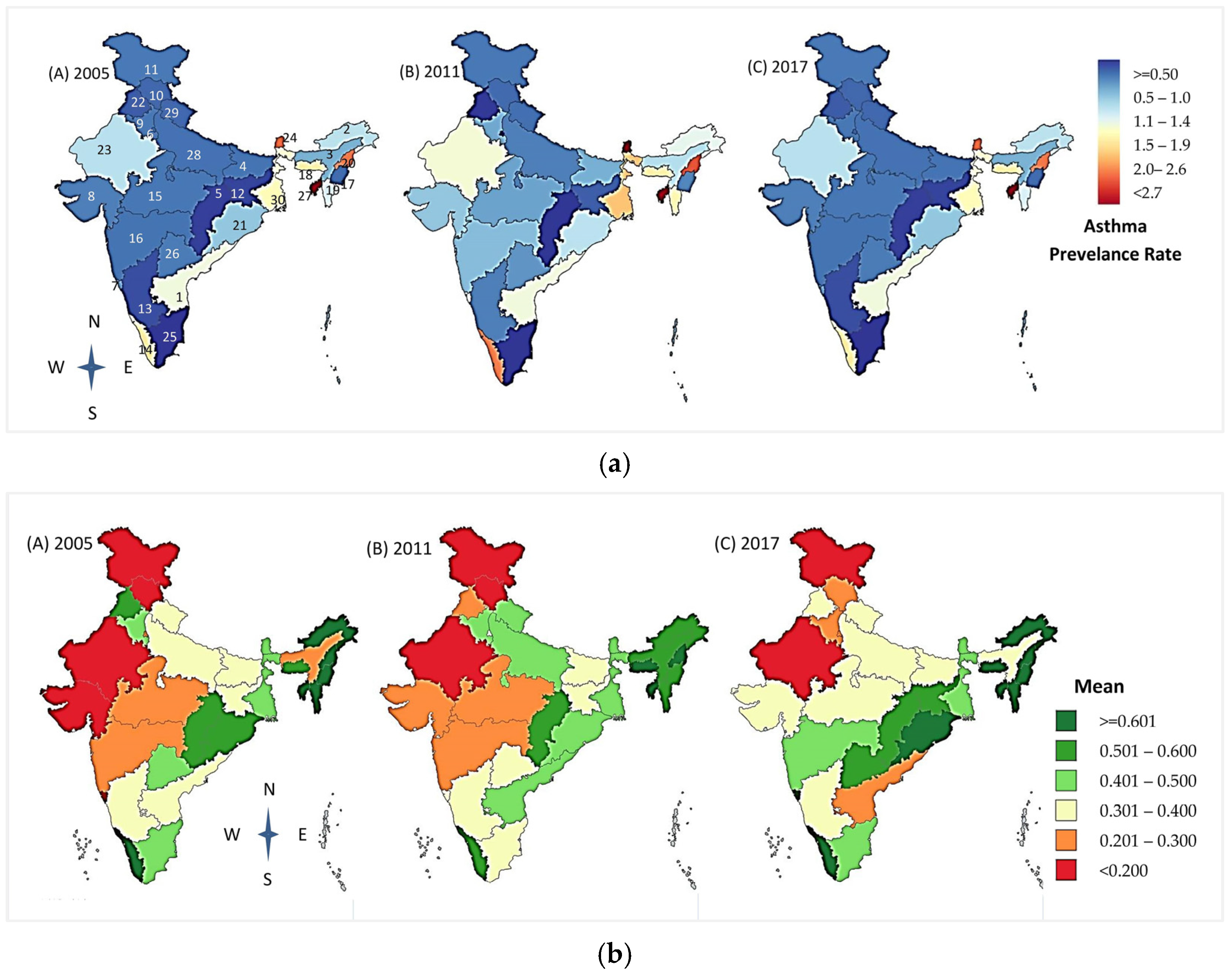
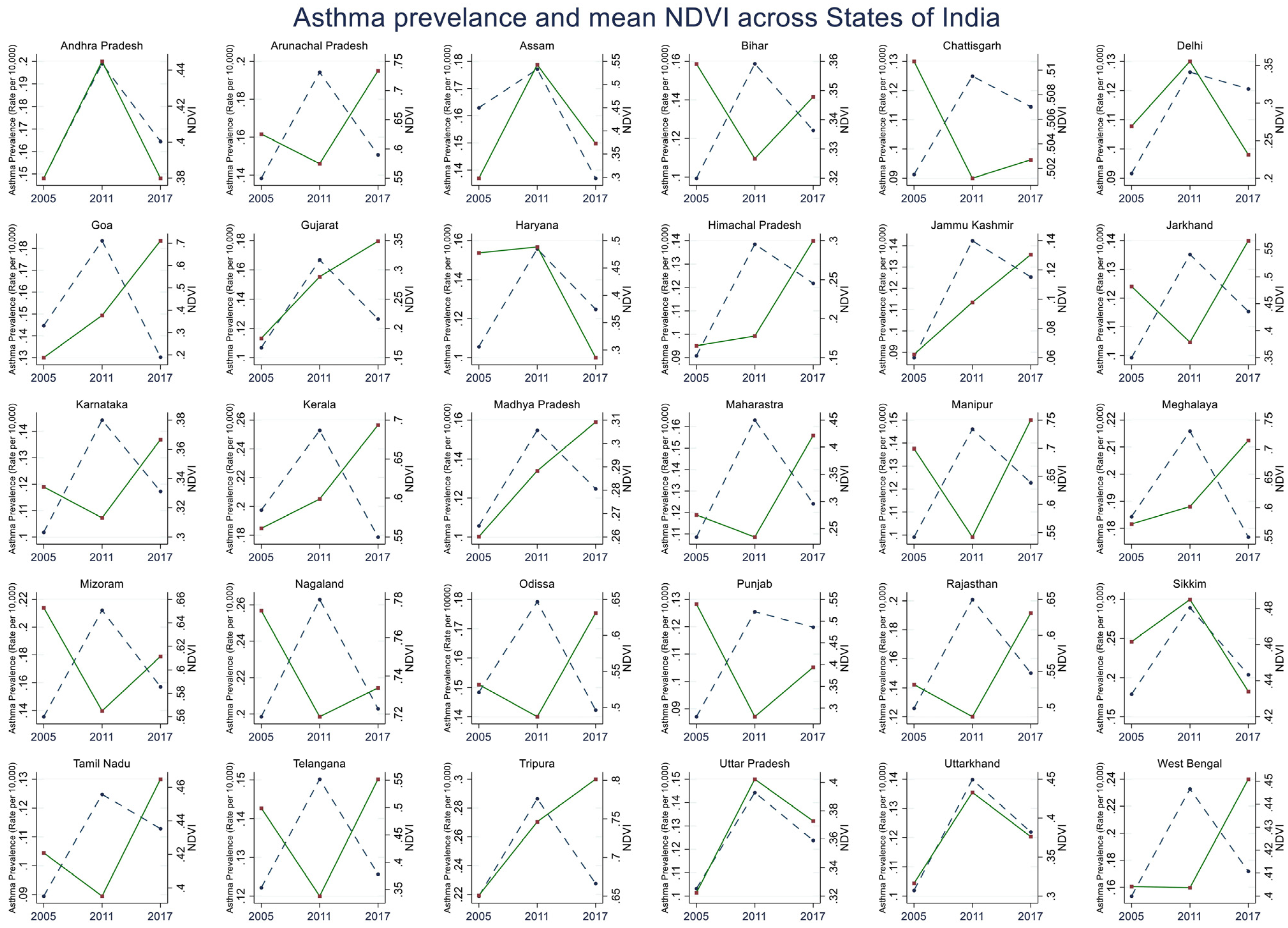
2.2.1. Outcome: Asthma Prevalence Data

The prevalence of asthma data by location, age, and year we derived from the Global Burden of Disease (GBD) data visualization tool developed by the Institute for Health Metrics and Evaluation (IHME), USA [41]. The state-wise prevalence of asthma was estimated using the terms defined in the GBD studies [42,43,44]. We calculated asthma prevalence estimates for the 29 states and Delhi for children aged 0 to 19 years across three time periods—2005, 2011, and 2017. Currently, GBD is the most reliable source in India, as it collates the data from the national databases of the federal government and extensive multicenter studies in India, including the International Study of Asthma and Allergies in Childhood (ISSAC) and the India Study on Epidemiology of Asthma, Respiratory Symptoms and Chronic Bronchitis (INSEARCH) studies [39,43,45].

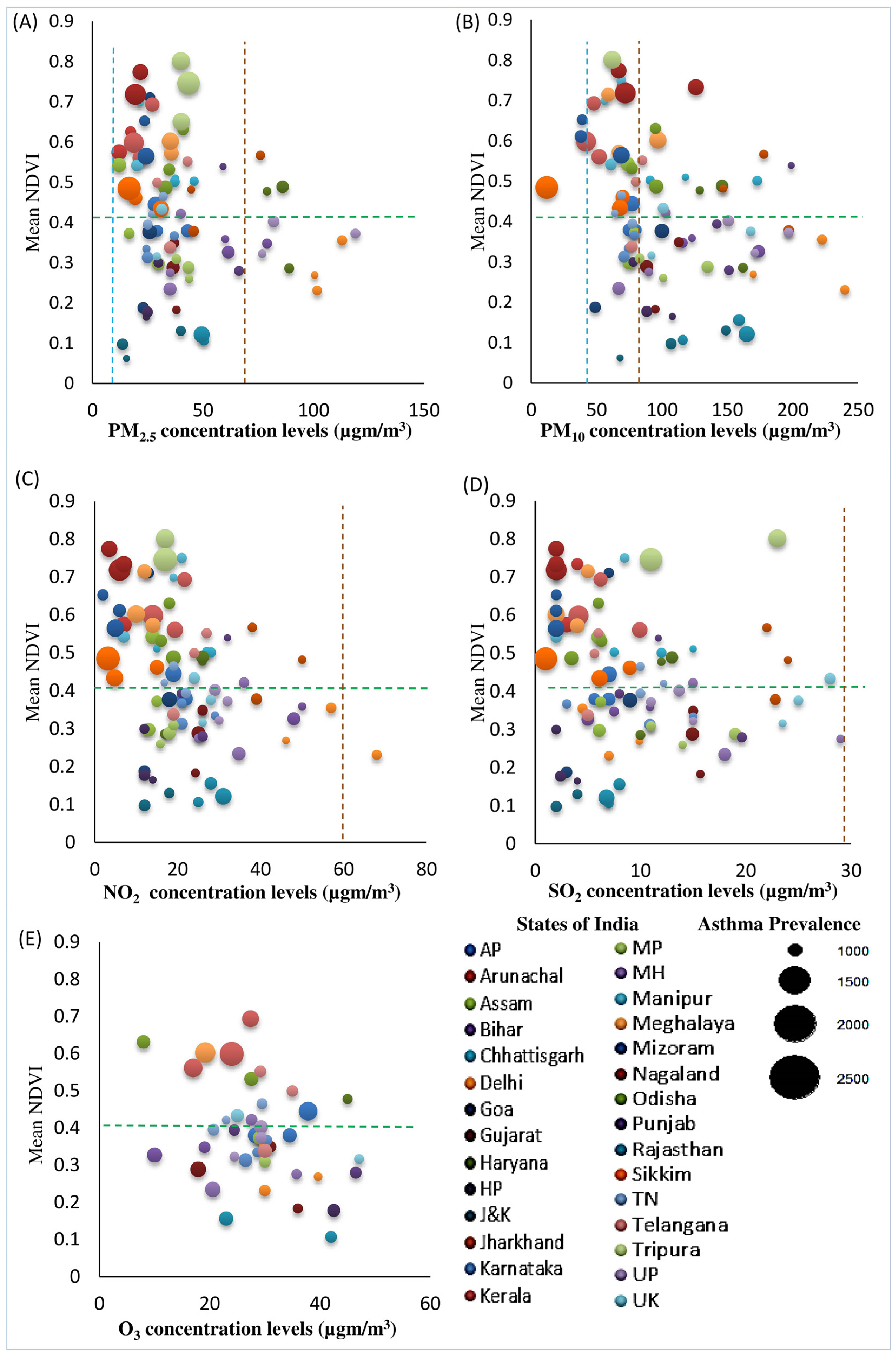
2.2.2. Exposures and Other Variables

Area Greenness: Greenness was obtained from Landsat Thematic Mapper Surface Reflectance images (https://earthexplorer.usgs.gov/, accessed on 5 May 2020), which we used to estimate the normalized differential vegetation index (NDVI). The Landsat images constituted the surface reflectance images generated every 16 days at a 30-m pixel spatial resolution and selected images for November. We obtained the next closest image if we missed or could not generate the surface reflectance images for that specific 16-day period. Similarly, the NDVI for each state was estimated across the three time points of 2005, 2011, and 2017. The selected cloud-free (<10 percent clouds) images avoided contamination with the NDVI values. An NDVI value of ‘0′ means no vegetation, and values close to ‘1′ represent the highest greenness [46]. The NDVI captured the density of greenness at a spatial resolution of 30 m and was calculated using the Quantum Geographical Information System (QGIS), Gnu General Public License, Version 2, 1991 Free Software Foundation, Inc. (Boston, MA, USA) tool v.3.12.3 9 [47]. The ratio of visible light (R) to the near-infrared (NIR) light reflected by the vegetative growth comprises the NDVI, that is, the surface reflectance of light during photosynthetic activity [46]. Greenness in a spatial area is defined as an average value of NDVI. The average NDVI values were calculated for the years 2005, 2011, and 2017, representing the annual greenspace exposure for the respective time periods in our study. The NDVI proportions were calculated using the following expression NDVI = (NIR − R)/(NIR + R)”.
Air pollution: The exposure estimates of air pollutants were from open data sources from the statutory organization the Central Pollution Control Board (CPCB) and its counterparts, the State Pollution Control Boards (SPCBs) of India. The annual average concentrations of particulate matter up to diameters of 2.5 µm (PM2.5) and 10 µm (PM10), nitrogen dioxide (NO2), sulfur dioxide (SO2), and ozone (O3) in µg/m3 were from the routine air quality monitoring stations of India for each of the years 2005, 2011, and 2017. We considered a small number of air pollutant data from reports, web pages, and details from the environmental information system (ENVIS) of the central pollution control board and state government. The published literature across 30 states in India contributed to some of the data on the average annual air pollutants, and data with different units of measure, such as parts per billion (ppb), were converted into micrograms per meter cube. Northeast India presents only recent years’ data, as the air quality monitoring stations across all seven states are recent. CPCB had first set the air quality standards in India in 1982, which were further revised by the year 2009, and the standards were higher than the air quality guidelines of WHO [48,49]. The National Air Quality Monitoring Program (NAMP), India, has set the National Ambient Air Quality Standards (NAAQS), with permissible limits for each of the air pollutants to protect public health, vegetation, and property [50].
Weather and other variables: The meteorological data for the states in India were recorded from online points of data collection—www.weatheronline.in, www.wunderground.com, and the Indian Meteorological Department (IMD); accessed on 15 December 2020—spanning 2005, 2011, and 2017. The meteorological parameters utilized were the annual average maximum temperature (degree Celsius), relative humidity (percentage), and average annual rainfall (millimeters). Population distribution in India is measured using the density of the population. Population density (PD) data across all states in 2005, 2011, and 2017 were included from the Census of India website, Refs. [51,52,53], representing the number of persons per square kilometer (km2). The Social Progress Index (SPI) is a tool reproduced by the Institute for Competitiveness and Social Progress Imperative that comprises facets of social progress on basic human needs, the foundation of wellbeing, and opportunity, which includes various components [54,55]. The SPI supplements economic success measures by directly measuring social and environmental outcomes. The scores range on a scale of 0–100 for each state. A higher state score indicates a better understanding of the relationship between economic gain and social progress.

2.3. Statistical Analysis
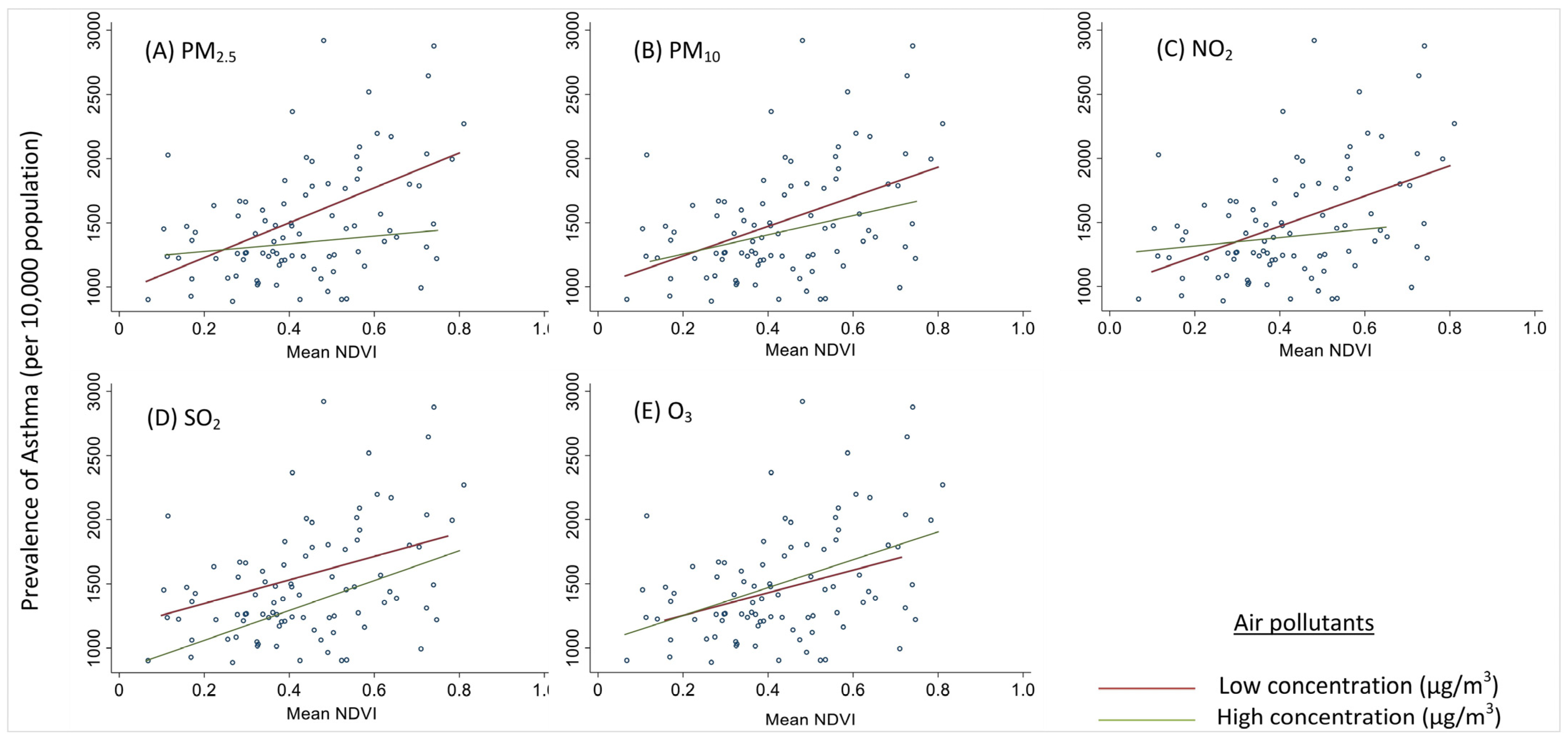
We used data visualization methods to illustrate the distribution of asthma prevalence in the India map chart across 29 states and Delhi over the years 2005, 2011, and 2017. The estimated mean NDVI values of the 29 states and 1 union territory (SUTs) projected spatial distributions of average greenness over 2005, 2011, and 2017. Similar graphical methods described the differences in the population rates with PM2.5 and O3 levels and asthma prevalence. Two-dimensional multiple line graphs were plotted to understand the pattern of association between asthma prevalence and the mean NDVI (Y1 and Y2-axis) over the periods on the horizontal axis (X-axis), created using Stata IC16 software(StataCorp, College Station, TX, USA). Statistical software R, v.3.6.3, was used to plot the multiple variables, using gg-plot for bubble charts and contour plots. The bubble plot is a multi-variable chart similar to a scatterplot and describes the average concentrations of the pollutants and the mean NDVI across the X-axis and Y-axis.
Spearman’s correlations were estimated to determine the levels of correlation among air pollutants (PM2.5, PM10, SO2, NO2, and O3), and between air pollutants and meteorological factors (maximum temperature, relative humidity, and average annual rainfall).
We first separately analyzed the association between the NDVI and the prevalence of asthma in each year (2005, 2011, and 2017), controlling for each air pollutant (PM2.5, PM10, SO2, NO2, and O3). For each year, the regression model approach that we took was modeling the outcome as a Poisson regression and adjusting it for meteorological parameters, PD, and SPI. We then used a generalized estimating equation (GEE) to estimate the association between the measure of greenness (NDVI) as the primary exposure variable and the prevalence of asthma as the outcome, using a Poisson link and combining the three time points in a single model. Additionally, we also examined the interaction between the NDVI and high air pollutant levels over the three time periods across all states in the GEE model. The air pollutant concentrations higher than the 75th centile were considered high. All statistical tests were 2-sided; effect estimates with a 95% confidence interval (CI) were reported and considered to have strong evidence of association if the p-value was less than 0.05. The statistical data analyses were performed using Stata IC 16 (StataCorp, College Station, TX, USA).

3. Results

The overall prevalence (min–max) of childhood and adolescent asthma for 0–19 years was 1275.56 (870.91–2188.52) cases per 100,000 in 2005, 1776.10 (1247.45–2894.67) cases per 100,000 in 2011, and 1419.97 (1128.66–2276.06) cases per 100,000 in 2017, representing an increase of 39.24% and a decrease of 20.05% between the three time periods (Table 1). Asthma in children and adolescents was more prevalent across the northeastern regions of India than in the rest (Figure 1A). The prevalence rates of asthma across all the states in India show a progressive increase from 2005 (1275 cases per 100,000) to 2011 (1776 cases per 100,000), and then present a downward trend until 2017 (1419 cases per 100,000) (Table 1). Though we observed a downward trend, all the states had a higher prevalence of asthma in 2017 compared to 2005 except for Assam (14.49% reduction in prevalence from 2005 to 2017), Goa (8.29%), Kerala (8.90%), Odisha (2.82%), and Meghalaya (2.49%).
The overall mean NDVI values in India were 0.43 in 2005, 0.42 in 2011, and 0.41 in 2017 (Figure 1B). The snow-capped and arid desert regions exhibited a low NDVI of around 0.06, and rich forest areas exhibited a high NDVI of 0.80. The greenest states in India with the highest NDVI values in 2005, 2011, and 2017 were in the northeast. The states with the lowest NDVI values included Jammu Kashmir, the northernmost state, which has many snow-capped months in a year; Rajasthan, a predominantly arid and desert area; and Himachal Pradesh, an alpine and subtropical climate. The NDVI values across all the states in India show a small reduction of around 2% over 12 years. There was a concordant change in the prevalence of asthma and the NDVI in the north and northeastern states and in the southern states of Goa, Andhra Pradesh, and Kerala, while divergent changes were present in most other states in India (Figure 2).
As expected, a strong correlation exists between PM2.5 and PM10, while there were weak to moderate correlations among the other air pollutants in this study (Supplementary Materials, Table S1). The maximum temperature (temp) levels were positively but weakly correlated with PM2.5, PM10, and NO2. The distributions of the NDVI, asthma rates, and particulate matter (PM2.5 and PM10) show a moderate negative correlation between the percentage of exposure to particulate matter (PM2.5 and PM10) and the mean NDVI (Figure 3). Compared to the distribution of particulate matter, many states with exposure to gaseous pollutants (SO2 and O3) had more variance, with many states showing high exposure (SO2 and O3) as well as high NDVI values, except for NO2 (Figure 3). All 30 states exceeded the ambient PM2.5 World Health Organization (WHO) air quality guideline, while 33% of the states exceeded the annual NAAQS (>40 µg/m3) in 2005 and 2011, and 50% of states exceeded it in 2017. Kerala (range 42–52 µg/m3) is the only state that did not exceed the NAAQS permissible limit (>60 µg/m3) for PM10 throughout 2005, 2011, and 2017.
The NDVI was associated with increased asthma prevalence rates in all three years (2005, 2011, and 2017) even after adjusting for individual pollutants (Supplementary Materials, Table S2). However, in the models adjusted for O3, the NDVI had no association with the asthma prevalence rates in 2011 and 2017.
We also analyzed all three years in one model. The univariate GEE models of high particulate matter, SO2, NO2, and O3 demonstrated a strong negative association with the prevalence of asthma, with only high PM10 showing a positive association (Table 2). The evidence of the association of the NDVI and air pollutants with asthma prevalence remained the same when adjusting for the weather parameters, socio-demographic factors such as the SPI, and population density, except for NO2 in this study. The NDVI, after adjustment for high levels of PM2.5, was positively associated with asthma prevalence (β = 0.144; 95% CI = 0.10, 0.186; p < 0.0001). In contrast, there was no association between the NDVI and asthma prevalence after adjustment for PM10 at high levels (β = 0.035; 95% CI = −0.006, 0.076; p = 0.096). The NDVI in the models, with high levels of both gaseous air pollutants, SO2, and NO2, was strongly positively associated with asthma prevalence ((β = 0.12; 95% CI = 0.08, 0.16; p < 0.0001) (β = 0.09; 95% CI = 0.05, 0.13; p < 0.0001)). In the model including high O3 levels, the NDVI shows a strong negative association with asthma prevalence (β = 0.19; 95% CI = 0.26, 0.11; p < 0.0001).
The strata-specific effects of low vs. high air pollution on the relationship between the NDVI and asthma prevalence are presented in Figure 4. In all cases except SO2, there was an interaction between the air pollutants and the NDVI in the GEE models (Table 3). The largest difference in the slopes can be observed in the PM2.5 and NO2 plots, where in the states with low concentrations of air pollutants, an increase in the mean NDVI is associated with an increase in asthma prevalence, with a greater rate of change.
Data presented for selected Indian states and union territories of the present study: (1) Andhra Pradesh, (2) Arunachal Pradesh, (3) Assam, (4) Bihar, (5) Chhattisgarh, (6) Delhi, (7) Goa, (8) Gujarat, (9) Haryana, (10) Himachal Pradesh, (11) Jammu and Kashmir, (12) Jharkhand, (13) Karnataka, (14) Kerala, (15) Madhya Pradesh, (16) Maharashtra, (17) Manipur, (18) Meghalaya, (19) Mizoram, (20) Nagaland, (21) Odisha, (22) Punjab, (23) Rajasthan, (24) Sikkim, (25) Tamil Nadu, (26) Telangana, (27) Tripura, (28) Uttar Pradesh, (29) Uttarkhand, and (30) West Bengal.
In Figure 1A, the rates of asthma prevalence in ages 0 to 19 years are shown on a spectrum of dark blue (0 prevalence) to dark red (highest prevalence) for the years 2005 (left panel), 2011 (middle panel), and 2017 (right panel). In Figure 1B, the normalized differential vegetation index (NDVI) values for 2005 (left), 2011 (middle), and 2017 (bottom), as calculated by the QGIS, are shown on a spectrum of red (least value) to dark green (highest value). These NDVI values relate to the distribution of the average level of greenness across 30 states. Mean NDVI values of 0 to 0.2 are categorized as low, >0.2 to 4.0 as moderate, and >0.4.0 as high levels of greenspaces. The darkest green areas consistently have the highest levels greenspace, while the red areas show the lowest levels of greenspace.
The lines on the graph represent the temporal trends of the series of data (broken blue lines represent the asthma prevalence rates and the green lines show the mean NDVI) over the three time periods of 2005, 2011, and 2017 along the horizontal axis (X-axis); the Y1-axis on the left is the asthma prevalence rate (blue), and the Y2-axis on the right is the mean NDVI (green).
Selected India states and union territories (SUTs) of the present study: (1) Andhra Pradesh, (2) Arunachal Pradesh, (3) Assam, (4) Bihar, (5) Chhattisgarh, (6) Delhi, (7) Goa, (8) Gujarat, (9) Haryana, (10) Himachal Pradesh, (11) Jammu and Kashmir, (12) Jharkhand, (13) Karnataka, (14) Kerala, (15) Madhya Pradesh, (16) Maharashtra, (17) Manipur, (18) Meghalaya, (19) Mizoram, (20) Nagaland, (21) Odisha, (22) Punjab, (23) Rajasthan, (24) Sikkim, (25) Tamil Nadu, (26) Telangana, (27) Tripura, (28) Uttar Pradesh, (29) Uttarkhand, and (30) West Bengal. Note: NDVI, normalized differential vegetation index.

4. Discussion

Our findings highlight that asthma prevalence was highest in the northeastern regions, followed by some parts of the eastern coastal plains, while semi-arid areas show low-prevalence estimates. As expected, the northeastern and east coast regions exhibited the highest levels of greenspaces, while the hot arid regions and the snow-capped regions exhibited the lowest levels of greenspaces. The present ecological study is the first state-wide study to show that greenspace is associated with childhood asthma prevalence in India. Our results suggest that greenspaces are positively associated with asthma prevalence in children, though this is not uniform across the geographical regions of India. Although this study enabled us to estimate asthma prevalence trends across the three periods (2005, 2011, and 2017), the established time trend and effect estimates indicate shifts in these trends over those years. Although no studies have assessed greenspace and childhood asthma in India, several studies in other regions have evaluated the effect of greenspace and asthma but reported inconsistent associations. Studies in Spain, New York, and Lithuania have observed that children (9–12 years, 7 years, and 4–6 years) residing close to greenspaces had an increased prevalence of asthma [28,29,32]. In contrast, studies from Cincinnati, Texas, the European region, and Canada have found no such association [56,57,58], and others from Spain, Australia, and Mexico have observed protective effects [27,59,60]. South Asian countries lack extensive studies on greenness and asthma to compare with our findings.
There are several hypotheses to explain these differences in the observations between greenspaces and their association with asthma. The outcomes, whether adverse (promoting asthma) or protective against asthma, depend on many co-factors. The timing of exposure to greenspaces may be a factor, that is, early-life exposure may have different outcomes than late-life exposure [31,33]. The type of greenspace seems to be relevant; while residences near forest greenspaces are protective, when they are near parks, an increase in the risk of asthma was observed [28]. Several studies have observed that parks and urban spaces may use exotic and non-native trees, which may increase exposure to pollens that have higher allergenicity [29,61]. Additionally, unlike forest greenspaces, there is a higher exposure to pesticides and fertilizers in urban greenspaces [62], increasing the risk of asthma. In some greenspaces, greater exposure to fungal spores increases the risk for asthma [63,64]. Protection from asthma has been observed due to improved air quality [19,22] and improved biodiversity, both at the macrobiota and the microbiota levels [62,63]. Decreased biodiversity has been associated with increased immune system dysfunction [65,66,67]. Higher greenness was associated with decreased air pollution, especially particulate matter, which offered protection in situations of heavy traffic pollution [59] but not in moderate or low traffic pollution. Studies have observed that children residing near a greater density of greenness are engaged in greater physical activity, while children in urban homes with less greenness lead more sedentary lifestyles and are obese, both of which are associated with a greater risk of asthma [68]. Differences in host responses due to various characteristics of the urban built-up environment, especially grey surfaces (which include industries, transport services, and the urban fabric) [69], indoor and outdoor environments, and differences in climate and geography, are all known to influence the complex interaction between greenspaces and asthma. In addition, residents of areas with higher greenness have been observed to have less stress, which impacts the psycho-neuroimmune and hypersensitive reactions to allergens [70,71,72,73]. The differences in the observations may also be due to the variable definitions used to diagnose asthma across studies and variable tools used to quantify greenspaces.
Only a few studies have evaluated the impact of greenspaces and air pollution on asthma, and the evidence is mixed [31,57]. Wide variations have been observed regarding the burden of air pollution, asthma prevalence, and greenspaces over time in different states in diverse countries such as India. When analyzed, a strong positive association was shown between asthma prevalence and greenspaces at high levels of PM2.5, PM10, NO2, and SO2, and a strong negative association was shown with O3. By examining interactions over time, our study observed the influence of greenspaces and air pollutants (PM2.5, PM10, SO2, NO2, and O3) on changes in childhood asthma prevalence at different concentration levels of air pollutants. In Australia, greater quantities of greenspace may buffer the impacts of heavy traffic exposure on childhood asthma [59]. Children living in areas with greenspace coverage of more than 40% had a much lower prevalence of asthma than children living in areas with less than 20% greenspace coverage [59]. An eight-year observational study in European (Spain, Germany, and Sweden) birth cohorts showed no associations among asthma, outdoor green environments, and exposure to NO2 [58]. The direction of associations among greenspaces, air pollution, and asthma are not always uniform, especially at different time points. In the US (New York), an increase in greenspace was associated with a 29% lower prevalence of asthma in the areas of increased proximity to air pollution sources [27], but a 17% increase in asthma prevalence was observed in areas with high traffic volumes (>1000 vehicles daily) [29]. Similar observations were made by Dadvand et al. in Spain on asthma prevalence, air pollution, and the NDVI at two time points (2012, 2014), and contradictory results have been found [28,31,33]. In another European study (Lithuania), higher greenness levels increased the risk of asthma prevalence when adjusting for PM2.5 and NO2 [32]. These differences in the direction of association in the same cities (New York, Spain) in two different time periods could be related to differences in the age range of the participants included in the two studies, the diverse analytical sample, the type of study design, the definition of asthma, changes in the quality and quantity of the air pollutants, or the vegetation in the city, similar to other study observations [28,29,32,56,74].
Several potential limitations are important to discuss in our nationwide study. First, the environmental exposure data across the states over all the time points were incomplete due to various reasons, such as, currently, there is a total of 703 air pollutant monitoring stations across all the states compared to 630 stations in the year 2005, while 3000 stations are expected to be established across Indian cities and towns by 2022 [75]. Nevertheless, we managed to retrieve additional data from national and state websites, reports of CPCB, and other studies, leading to uncertainties in the data quality. Still, we used a robust and efficient GEE model to obtain unbiased estimations of the average population. Second, our study presents the findings for the annual average estimates rather than the monthly or daily data, and we might have lost the trends of the short-term effects of environmental exposures. Third, the focus of our study was exploratory, so graphically presenting the differences in the results overcomes this. In addition, using the NDVI tool for estimating greenspaces would have captured some differences in the rural and urban characteristics; however, we would have missed some relative differences in the suburban and urban areas. The NDVI does not account for the vegetation type (denser vs. scarce; natural vs. artificial), and hence, the association may not be detailed; comprehensive assessments can combine different greenspace estimation methods in future research. Studying source-specific roles of each air pollutant [76,77] and their composition was beyond our scope; still, they give a better understanding of the temporal variations along with their distributions across regions.

5. Conclusions

In India, greenspace varies over a wide range across states and is associated with increased asthma prevalence, but the association does depend on varying air pollutants in different states. Government initiatives are contributing to green growth, and the smart city initiatives developed in 2017 will continue to further boost the sustained development in urban cities. This is the first study in India, and our study findings contribute to the growing literature on greenspaces and their effects on health under variable environmental factors.

Supplementary Materials

The following supporting information can be downloaded at: https://www.mdpi.com/article/10.3390/ijerph192215273/s1, Table S1: Correlations and p-values between the air pollutants and meteorological variables; Table S2: The estimates for asthma prevalence rates and NDVI at each of the air pollutants concentrations for the years 2005, 2011, and 2017.

Author Contributions

Conceptualization, B.E. and M.P.A.; methodology, B.E. and K.A.L.; software, S.M.; validation, S.M. and K.A.L.; formal analysis, S.M.; investigation, K.A.L.; resources, S.M.; data curation; S.M.; writing—original draft preparation, S.M.; writing—review and editing, M.P.A. and B.E.; visualization, A.S.P. and S.M.; supervision, M.P.A.; project administration, B.E. All authors have read and agreed to the published version of the manuscript.

Funding

This research received no external funding.

Institutional Review Board Statement

Not applicable.

Informed Consent Statement

Not applicable.

Data Availability Statement

The data presented in this study are available upon request from the corresponding author.

Acknowledgments

This study used information from the Global Burden of Diseases, Injuries, and Risk Factors Study (GBD), coordinated by the Institute for Health Metrics and Evaluation. Estimating area greenness could not have been possible without the Earth Resources Observation and Science (EROS) Center data from the US Geological Survey and the National Aeronautics and Space Administration (NASA).

Conflicts of Interest

The authors declare no conflict of interest.

References

  1. GINA. Global Strategy for Asthma Management and Prevention; Global INitiative for Asthma: Washington, WA, USA, 2022; pp. 1–222. Available online: www.ginasthma.org (accessed on 30 October 2022).
  2. Soriano, J.B.; Kendrick, P.J.; Paulson, K.R.; Gupta, V.; Abrams, E.M.; Adedoyin, R.A.; Adhikari, T.B.; Advani, S.M.; Agrawal, A.; Ahmadian, E. Prevalence and attributable health burden of chronic respiratory diseases, 1990–2017: A systematic analysis for the Global Burden of Disease Study 2017. Lancet Respir. Med. 2020, 8, 585–596. [Google Scholar] [CrossRef]
  3. Ferrante, G.; La Grutta, S. The burden of pediatric asthma. Front. Pediatr. 2018, 6, 2296–2360. [Google Scholar] [CrossRef] [PubMed] [Green Version]
  4. Asher, M.I.; Rutter, C.E.; Bissell, K.; Chiang, C.-Y.; El Sony, A.; Ellwood, E.; Ellwood, P.; García-Marcos, L.; Marks, G.B.; Morales, E. Worldwide trends in the burden of asthma symptoms in school-aged children: Global Asthma Network Phase I cross-sectional study. The Lancet 2021, 398, 1569–1580. [Google Scholar] [CrossRef]
  5. Gehring, U.; Wijga, A.H.; Brauer, M.; Fischer, P.; de Jongste, J.C.; Kerkhof, M.; Oldenwening, M.; Smit, H.A.; Brunekreef, B. Traffic-related air pollution and the development of asthma and allergies during the first 8 years of life. Am. J. Respir. Crit. Care Med. 2010, 181, 596–603. [Google Scholar] [CrossRef] [PubMed] [Green Version]
  6. Rancière, F.; Bougas, N.; Viola, M.; Momas, I. Early exposure to traffic-related air pollution, respiratory symptoms at 4 years of age, and potential effect modification by parental allergy, stressful family events, and sex: A prospective follow-up study of the PARIS birth cohort. Environ. Health Perspect. 2017, 125, 737–745. [Google Scholar] [CrossRef]
  7. Martinez, F.D. Asthma. Lancet 2013, 382, 1360–1372. [Google Scholar] [CrossRef]
  8. Van Tilburg Bernardes, E.; Arrieta, M.-C. Hygiene hypothesis in asthma development: Is hygiene to blame? Arch. Med. Res. 2017, 48, 717–726. [Google Scholar] [CrossRef]
  9. Thien, F.; Beggs, P.J.; Csutoros, D.; Darvall, J.; Hew, M.; Davies, J.M.; Bardin, P.G.; Bannister, T.; Barnes, S.; Bellomo, R.; et al. The Melbourne epidemic thunderstorm asthma event 2016: An investigation of environmental triggers, effect on health services, and patient risk factors. Lancet Planet Health 2018, 2, e255–e263. [Google Scholar] [CrossRef]
  10. Global Asthma Network. Global Asthma Report 2018; Global Asthma Network: Auckland, New Zealand, 2018; Available online: http://www.globalasthmanetwork.org/ (accessed on 3 January 2021).
  11. Singh, S.; Salvi, S.; Mangal, D.K.; Singh, M.; Awasthi, S.; Mahesh, P.A.; Kabra, S.K.; Mohammed, S.; Sukumaran, T.U.; Ghoshal, A.G. Prevalence, time trends and treatment practices of asthma in India: Global Asthma Network study. ERJ Open Res. 2022, 8, 00528-2021. [Google Scholar] [CrossRef]
  12. García-Marcos, L.; Asher, M.I.; Pearce, N.; Ellwood, E.; Bissell, K.; Chiang, C.-Y.; El Sony, A.; Ellwood, P.; Marks, G.B.; Mortimer, K. The burden of asthma, hay fever and eczema in children in 25 countries: GAN Phase I study. Eur. Respir. J. 2022, 60, 2102866. [Google Scholar] [CrossRef]
  13. Markevych, I.; Schoierer, J.; Hartig, T.; Chudnovsky, A.; Hystad, P.; Dzhambov, A.M.; De Vries, S.; Triguero-Mas, M.; Brauer, M.; Nieuwenhuijsen, M.J. Exploring pathways linking greenspace to health: Theoretical and methodological guidance. Environ. Res. 2017, 158, 301–317. [Google Scholar] [CrossRef] [PubMed]
  14. Lambert, K.; Bowatte, G.; Tham, R.; Lodge, C.; Prendergast, L.; Heinrich, J.; Abramson, M.J.; Dharmage, S.; Erbas, B. Residential greenness and allergic respiratory diseases in children and adolescents–a systematic review and meta-analysis. Environ. Res. 2017, 159, 212–221. [Google Scholar] [CrossRef]
  15. Bowatte, G.; Lodge, C.J.; Knibbs, L.D.; Erbas, B.; Perret, J.L.; Jalaludin, B.; Morgan, G.G.; Bui, D.S.; Giles, G.G.; Hamilton, G.S.; et al. Traffic related air pollution and development and persistence of asthma and low lung function. Environ. Int. 2018, 113, 170–176. [Google Scholar] [CrossRef] [PubMed]
  16. Evans, K.A.; Halterman, J.S.; Hopke, P.K.; Fagnano, M.; Rich, D.Q. Increased ultrafine particles and carbon monoxide concentrations are associated with asthma exacerbation among urban children. Environ. Res. 2014, 129, 11–19. [Google Scholar] [CrossRef] [PubMed] [Green Version]
  17. Anenberg, S.C.; Henze, D.K.; Tinney, V.; Kinney, P.L.; Raich, W.; Fann, N.; Malley, C.S.; Roman, H.; Lamsal, L.; Duncan, B.; et al. Estimates of the Global Burden of Ambient PM2.5, Ozone, and NO2 on Asthma Incidence and Emergency Room Visits. Environ. Health Perspect. 2018, 126, 107004. [Google Scholar] [CrossRef] [Green Version]
  18. Pawankar, R.; Wang, J.-Y.; Wang, I.-J.; Thien, F.; Chang, Y.-S.; Latiff, A.H.A.; Fujisawa, T.; Zhang, L.; Thong, B.Y.-H.; Chatchatee, P. Asia Pacific Association of Allergy Asthma and Clinical Immunology White Paper 2020 on climate change, air pollution, and biodiversity in Asia-Pacific and impact on allergic diseases. Asia Pac. Allergy 2020, 10. [Google Scholar] [CrossRef] [Green Version]
  19. Lelieveld, J.; Evans, J.S.; Fnais, M.; Giannadaki, D.; Pozzer, A. The contribution of outdoor air pollution sources to premature mortality on a global scale. Nature 2015, 525, 367–371. [Google Scholar] [CrossRef]
  20. WHO. Air Pollution. Available online: https://www.who.int/health-topics/air-pollution? (accessed on 21 January 2021).
  21. Cohen, A.J.; Brauer, M.; Burnett, R.; Anderson, H.R.; Frostad, J.; Estep, K.; Balakrishnan, K.; Brunekreef, B.; Dandona, L.; Dandona, R. Estimates and 25-year trends of the global burden of disease attributable to ambient air pollution: An analysis of data from the Global Burden of Diseases Study 2015. Lancet 2017, 389, 1907–1918. [Google Scholar] [CrossRef] [Green Version]
  22. Erbas, B.; Kelly, A.-M.; Physick, B.; Code, C.; Edwards, M. Air pollution and childhood asthma emergency hospital admissions: Estimating intra-city regional variations. Int. J. Environ. Health Res. 2005, 15, 11–20. [Google Scholar] [CrossRef]
  23. O’Connor, G.T.; Neas, L.; Vaughn, B.; Kattan, M.; Mitchell, H.; Crain, E.F.; Evans Iii, R.; Gruchalla, R.; Morgan, W.; Stout, J. Acute respiratory health effects of air pollution on children with asthma in US inner cities. J. Allergy Clin. Immunol. 2008, 121, 1133–1139. [Google Scholar] [CrossRef]
  24. Guarnieri, M.; Balmes, J.R. Outdoor air pollution and asthma. Lancet 2014, 383, 1581–1592. [Google Scholar] [CrossRef] [Green Version]
  25. Khilnani, C.G.; Tiwari, C.P. Air pollution in India and related adverse respiratory health effects: Past, present, and future directions. Curr. Opin. Pulm. Med. 2018, 24, 108–116. [Google Scholar] [CrossRef] [PubMed]
  26. WHO. Concentrations of Fine Particulate Matter (PM2.5). Available online: https://www.who.int/data/gho/data/indicators/indicator-details/GHO/concentrations-of-fine-particulate-matter-(pm2-5) (accessed on 29 October 2022).
  27. Lovasi, G.S.; Quinn, J.W.; Neckerman, K.M.; Perzanowski, M.S.; Rundle, A. Children living in areas with more street trees have lower prevalence of asthma. J. Epidemiol. Community Health 2008, 62, 647–649. [Google Scholar] [CrossRef] [PubMed] [Green Version]
  28. Dadvand, P.; Villanueva, C.M.; Font-Ribera, L.; Martinez, D.; Basagaña, X.; Belmonte, J.; Vrijheid, M.; Gražulevičienė, R.; Kogevinas, M.; Nieuwenhuijsen, M.J. Risks and benefits of green spaces for children: A cross-sectional study of associations with sedentary behavior, obesity, asthma, and allergy. Environ. Health Perspect. 2014, 122, 1329–1335. [Google Scholar] [CrossRef] [PubMed]
  29. Lovasi, G.S.; O’Neil-Dunne, J.P.M.; Lu, J.W.T.; Sheehan, D.; Perzanowski, M.S.; MacFaden, S.W.; King, K.L.; Matte, T.; Miller, R.L.; Hoepner, L.A. Urban tree canopy and asthma, wheeze, rhinitis, and allergic sensitization to tree pollen in a New York City birth cohort. Environ. Health Perspect. 2013, 121, 494–500. [Google Scholar] [CrossRef] [Green Version]
  30. Ferrante, G.; Asta, F.; Cilluffo, G.; De Sario, M.; Michelozzi, P.; La Grutta, S. The effect of residential urban greenness on allergic respiratory diseases in youth: A narrative review. World Allergy Organ. J. 2020, 13, 1939–4551. [Google Scholar] [CrossRef] [Green Version]
  31. Dadvand, P.; Sunyer, J.; Basagana, X.; Ballester, F.; Lertxundi, A.; Fernandez-Somoano, A.; Estarlich, M.; Garcia-Esteban, R.; Mendez, M.A.; Nieuwenhuijsen, M.J. Surrounding greenness and pregnancy outcomes in four Spanish birth cohorts. Environ. Health Perspect. 2012, 120, 1481–1487. [Google Scholar] [CrossRef]
  32. Andrusaityte, S.; Grazuleviciene, R.; Kudzyte, J.; Bernotiene, A.; Dedele, A.; Nieuwenhuijsen, M.J. Associations between neighbourhood greenness and asthma in preschool children in Kaunas, Lithuania: A case–control study. BMJ open 2016, 6, e010341. [Google Scholar] [CrossRef] [Green Version]
  33. Dadvand, P.; de Nazelle, A.; Triguero-Mas, M.; Schembari, A.; Cirach, M.; Amoly, E.; Figueras, F.; Basagaña, X.; Ostro, B.; Nieuwenhuijsen, M. Surrounding greenness and exposure to air pollution during pregnancy: An analysis of personal monitoring data. Environ. Health Perspect. 2012, 120, 1286–1290. [Google Scholar] [CrossRef]
  34. United Nations. World Population Prospects: The 2017 Revision, Key Findings and Advance Tables; Working Paper No. ESA/P/WP/248; Department of Economic and Social Affairs: New York, NY, USA, 2017; p. 53. Available online: https://population.un.org/wpp/Publications/Files/WPP2017_KeyFindings.pdf (accessed on 12 January 2021).
  35. GBD Chronic Respiratory Disease Collaborators. Global, regional, and national deaths, prevalence, disability-adjusted life years, and years lived with disability for chronic obstructive pulmonary disease and asthma, 1990–2015: A systematic analysis for the Global Burden of Disease Study 2015. Lancet. Respir. Med. 2017, 5, 691–706. [Google Scholar] [CrossRef]
  36. WHO. Ambient Air Pollution Data. Available online: https://www.who.int/data/gho/data/themes/air-pollution/ambient-air-pollution (accessed on 21 January 2021).
  37. IQAir. World Air Quality Report: Region & City PM2.5 Ranking; IQAir: Goldach, Switzerland, 2020; pp. 1–40. Available online: https://www.iqair.com/world-most-polluted-cities/world-air-quality-report-2020-en.pdf (accessed on 12 December 2020).
  38. Chowdhury, S.; Dey, S. Cause-specific premature death from ambient PM2. 5 exposure in India: Estimate adjusted for baseline mortality. Environ. Int. 2016, 91, 283–290. [Google Scholar] [CrossRef] [PubMed]
  39. Salvi, S.; Kumar, G.A.; Dhaliwal, R.S.; Paulson, K.; Agrawal, A.; Koul, P.A.; Mahesh, P.A.; Nair, S.; Singh, V.; Aggarwal, A.N. The burden of chronic respiratory diseases and their heterogeneity across the states of India: The Global Burden of Disease Study 1990–2016. Lancet Glob. Health 2018, 6, e1363–e1374. [Google Scholar] [CrossRef] [Green Version]
  40. Chokshi, M.; Patil, B.; Khanna, R.; Neogi, S.B.; Sharma, J.; Paul, V.K.; Zodpey, S. Health systems in India. J. Perinatol. 2016, 36, S9–S12. [Google Scholar] [CrossRef]
  41. Institute for Health Metrics and Evaluation. GBD Compare. Available online: http://vizhub.healthdata.org/gbd-compare (accessed on 16 October 2021).
  42. Indian Council of Medical Research Public Health Foundation of India Institute of Health Metrics and Evaluation. GBD India Compare Data Visualization; IHME, University of Washington: Seattle, WA, USA, 2019; Available online: http://vizhub.healthdata.org/gbd-compare/india (accessed on 21 October 2020).
  43. Lai, C.K.; Beasley, R.; Crane, J.; Foliaki, S.; Shah, J.; Weiland, S.; Group, I.P.T.S. Global variation in the prevalence and severity of asthma symptoms: Phase three of the International Study of Asthma and Allergies in Childhood (ISAAC). Thorax 2009, 64, 476–483. [Google Scholar] [CrossRef] [PubMed] [Green Version]
  44. Sinha, S.; Singh, J.; Kumar Jindal, S.; Birbian, N. Association of IL13R alpha 1+ 1398A/G polymorphism in a North Indian population with asthma: A case-control study. Allergy Rhinol. Provid. 2015, 6, 111–117. [Google Scholar] [CrossRef] [PubMed] [Green Version]
  45. Jindal, S.K.; Aggarwal, A.N.; Gupta, D.; Agarwal, R.; Kumar, R.; Kaur, T.; Chaudhry, K.; Shah, B. Indian Study on Epidemiology of Asthma, Respiratory Symptoms and Chronic Bronchitis in adults (INSEARCH). Int. J. Tuberc. Lung Dis. 2012, 16, 1270–1277. [Google Scholar] [CrossRef]
  46. Weier, J.; Herring, D. Measuring Vegetation (NDVI & EVI). Available online: http://earthobservatory.nasa.gov/Features/MeasuringVegetation (accessed on 15 January 2021).
  47. QGIS Development Team Open Source Geospatial Foundation Project. Quantum Geographic Information System. Available online: https://www.qgis.org (accessed on 15 October 2020).
  48. Ministry of Environment Forest and Climate Change. Revised National Ambient Air Quality Standards (NAAQS) 2009 Notified. 2009. Available online: http://moef.gov.in/wp-content/uploads/2019/10/Press-Note-on-RNAAQS_1.pdf (accessed on 21 June 2020).
  49. Central Pollution Control Board India. National Ambient Air Quality Standards Central Pollution Control Board Notification in the Gazette of India, Extraordinary. Available online: http://www.cpcb.nic.in/upload/Latest/Latest_48_FINAL_AIR_STANDARD.pdf (accessed on 21 August 2021).
  50. Central Pollution Control Board. National Ambient Air Quality Status and Trends 2019. 2019, 156. Available online: http://www.cpcb.nic.in (accessed on 21 August 2021).
  51. Government of India. Census of India 2011. Available online: http://dataforall.org/dashboard/censusinfoindia_pca/ (accessed on 21 June 2020).
  52. Government of India. Census of India 2011; 00-001-2011-Cen-Book (E); Office of Registerar General of India: New Delhi, India, 2011; pp. 1–13. Available online: https://censusindia.gov.in/2011-prov-results/data_files/india/paper_contentsetc.pdf (accessed on 23 June 2020).
  53. Ministry of Statistics and Program Implementation. Children in India 2018—A Statistical Appraisal; Social Statistics Division-Central Statistics Office, Government of India: New Delhi, India, 2018; pp. 1–138. Available online: https://www.mospi.gov.in (accessed on 21 January 2021).
  54. Kapoor, A.; Kapoor, M.; Krylova, P. Social Progress Index: States of India 2005–2016, Methodology Report; Institute for Competitiveness: Gurgaon, India, 2017; pp. 1–34. Available online: https://socialprogress.in/wp-content/uploads/2017/10/SPI_2017_Methodology.pdf (accessed on 12 December 2020).
  55. Kapoor, A.; Kapoor, M.; Krylova, P. Social Progress Index: States of India 2005–2016, Eleven Years of Progress Report Findings; Institute for Competitiveness: Gurgaon, India, 2017; pp. 1–120. Available online: https://socialprogress.in/wp-content/uploads/2017/10/SPI_2017_Findings.pdf (accessed on 12 December 2020).
  56. Pilat, M.A.; McFarland, A.; Snelgrove, A.; Collins, K.; Waliczek, T.M.; Zajicek, J. The effect of tree cover and vegetation on incidence of childhood asthma in metropolitan statistical areas of Texas. HortTechnology 2012, 22, 631–637. [Google Scholar] [CrossRef] [Green Version]
  57. Sbihi, H.; Koehoorn, M.; Tamburic, L.; Brauer, M. Asthma trajectories in a population-based birth cohort. Impacts of air pollution and greenness. Am. J. Respir. Crit. Care Med. 2017, 195, 607–613. [Google Scholar] [CrossRef]
  58. Tischer, C.; Dadvand, P.; Basagana, X.; Fuertes, E.; Bergström, A.; Gruzieva, O.; Melen, E.; Berdel, D.; Heinrich, J.; Koletzko, S. Urban upbringing and childhood respiratory and allergic conditions: A multi-country holistic study. Environ. Res. 2018, 161, 276–283. [Google Scholar] [CrossRef] [Green Version]
  59. Feng, X.; Astell-Burt, T. Is neighborhood green space protective against associations between child asthma, neighborhood traffic volume and perceived lack of area safety? Multilevel analysis of 4447 Australian children. Int. J. Environ. Res. Public Health 2017, 14, 543. [Google Scholar] [CrossRef]
  60. Eldeirawi, K.; Kunzweiler, C.; Zenk, S.; Finn, P.; Nyenhuis, S.; Rosenberg, N.; Persky, V. Associations of urban greenness with asthma and respiratory symptoms in Mexican American children. Ann. Allergy Asthma Immunol. 2019, 122, 289–295. [Google Scholar] [CrossRef] [PubMed]
  61. DellaValle, C.T.; Triche, E.W.; Leaderer, B.P.; Bell, M.L. Effects of ambient pollen concentrations on frequency and severity of asthma symptoms among asthmatic children. Epidemiology 2012, 23, 55. [Google Scholar] [CrossRef] [PubMed] [Green Version]
  62. Corsini, E.; Sokooti, M.; Galli, C.L.; Moretto, A.; Colosio, C. Pesticide induced immunotoxicity in humans: A comprehensive review of the existing evidence. Toxicology 2013, 307, 123–135. [Google Scholar] [CrossRef]
  63. Bartra, J.; Belmonte, J.; Torres-Rodriguez, J.M.; Cistero-Bahima, A. Sensitization to Alternaria in patients with respiratory allergy. Front. Biosci. 2009, 14, 9. [Google Scholar] [CrossRef] [Green Version]
  64. De Linares, C.; Belmonte, J.; Canela, M.; de la Guardia, C.D.; Alba-Sanchez, F.; Sabariego, S.; Alonso-Pérez, S. Dispersal patterns of Alternaria conidia in Spain. Agric. For. Meteorol. 2010, 150, 1491–1500. [Google Scholar] [CrossRef]
  65. Rook, G.A. Regulation of the immune system by biodiversity from the natural environment: An ecosystem service essential to health. Proc. Natl. Acad. Sci. USA 2013, 110, 18360–18367. [Google Scholar] [CrossRef] [PubMed] [Green Version]
  66. Hanski, I.; von Hertzen, L.; Fyhrquist, N.; Koskinen, K.; Torppa, K.; Laatikainen, T.; Karisola, P.; Auvinen, P.; Paulin, L.; Mäkelä, M.J.; et al. Environmental biodiversity, human microbiota, and allergy are interrelated. Proc. Natl. Acad. Sci. USA 2012, 109, 8334–8339. [Google Scholar] [CrossRef] [PubMed] [Green Version]
  67. Mhuireach, G.; Johnson, B.R.; Altrichter, A.E.; Ladau, J.; Meadow, J.F.; Pollard, K.S.; Green, J.L. Urban greenness influences airborne bacterial community composition. Sci. Total Environ. 2016, 571, 680–687. [Google Scholar] [CrossRef] [Green Version]
  68. Baiardini, I.; Sicuro, F.; Balbi, F.; Canonica, G.W.; Braido, F. Psychological aspects in asthma: Do psychological factors affect asthma management? Asthma Res. Pract. 2015, 1, 1–6. [Google Scholar] [CrossRef] [Green Version]
  69. Tischer, C.; Gascon, M.; Fernández-Somoano, A.; Tardón, A.; Materola, A.L.; Ibarluzea, J.; Ferrero, A.; Estarlich, M.; Cirach, M.; Vrijheid, M. Urban green and grey space in relation to respiratory health in children. Eur. Respir. J. 2017, 49, 1502112. [Google Scholar] [CrossRef]
  70. Astell-Burt, T.; Feng, X.; Kolt, G.S. Mental health benefits of neighbourhood green space are stronger among physically active adults in middle-to-older age: Evidence from 260,061 Australians. Prev. Med. 2013, 57, 601–606. [Google Scholar] [CrossRef] [PubMed]
  71. Chen, E.; Schreier, H.M.C.; Strunk, R.C.; Brauer, M. Chronic traffic-related air pollution and stress interact to predict biologic and clinical outcomes in asthma. Environ. Health Perspect. 2008, 116, 970–975. [Google Scholar] [CrossRef] [PubMed] [Green Version]
  72. Islam, M.N.; Rahman, K.-S.; Bahar, M.M.; Habib, M.A.; Ando, K.; Hattori, N. Pollution attenuation by roadside greenbelt in and around urban areas. Urban For. Urban Green. 2012, 11, 460–464. [Google Scholar] [CrossRef]
  73. Shankardass, K.; McConnell, R.; Jerrett, M.; Milam, J.; Richardson, J.; Berhane, K. Parental stress increases the effect of traffic-related air pollution on childhood asthma incidence. Proc. Natl. Acad. Sci. USA 2009, 106, 12406–12411. [Google Scholar] [CrossRef] [PubMed] [Green Version]
  74. Sbihi, H.; Tamburic, L.; Koehoorn, M.; Brauer, M. Greenness and Incident Childhood Asthma: A 10-Year Follow-up in a Population-based Birth Cohort. Am. J. Respir. Crit. Care Med. 2015, 192, 1131–1133. [Google Scholar] [CrossRef] [PubMed]
  75. Indian Institute of Management. Evaluation of Central Pollution Control Board (CPCB); Ministry of Environment and Forest Government of India (GOI): Lucknow, India, 2010; p. 70. Available online: http://cpcbnicin/cpcbold/IIMLkopdf (accessed on 21 December 2020).
  76. Srivastava, A.; Gupta, S.; Jain, V.K. Source Apportionment of Total Suspended Particulate Matter in Coarse and Fine Size Ranges Over Delhi. Aerosol Air Qual. Res. 2008, 8, 188–200. [Google Scholar] [CrossRef] [Green Version]
  77. Saxena, M.; Sharma, A.; Sen, A.; Saxena, P.; Saraswati; Mandal, T.K.; Sharma, S.K.; Sharma, C. Water soluble inorganic species of PM10 and PM2.5 at an urban site of Delhi, India: Seasonal variability and sources. Atmos. Res. 2017, 184, 112–125. [Google Scholar] [CrossRef]
Figure 1. Distribution of (a) asthma prevalence rate, (b) NDVI across states and union territories in India in 2005, 2011, and 2017.
Ijerph 19 15273 g001
Figure 2. Asthma prevalence rate (per 10,000 population) and mean NDVI across 29 states and 1 union territory (SUTs) of India in 2005, 2011, and 2017.
Ijerph 19 15273 g002
Figure 3. Mean NDVI vs. concentration of air pollutants (A) PM2.5, (B) PM10, (C) NO2, (D) SO2, and (E) O3 (in µg/m3) across SUTs in the years 2005, 2011, and 2017. Note: The left panel shows the association of the mean NDVI along the Y-axis and the PM2.5 concentration levels in the X-axis with the asthma prevalence rates across states as bubbles in the three time periods of 2005, 2011, and 2017. The right panel shows the association of the mean NDVI along the Y-axis and the PM10 concentration levels on the X-axis with the asthma prevalence rate across states. Similarly, the middle panel on the left presents the NO2 concentration levels, and the middle right presents the SO2 concentration levels. The bottom left panel shows the association of the mean NDVI (Y-axis) and changes in the concentration levels of O3 (X-axis) with the prevalence rate of asthma, represented as bubbles in the right panel. Each of the bubbles measures the asthma prevalence rate of each state in the three time periods. Increases in the size of the bubbles represent increases in the asthma prevalence rate and vice-versa. The colors of the bubble represent each state presented on the right side of the panel. Within the graph, the broken blue lines represent the cut-off levels for air pollutant concentration levels as per the World Health Organization (WHO) standards; the brown lines represent the cut-off levels for air pollutants as per the National Ambient Air Quality Standards, India (NAAQS), and the green lines show the mean NDVI values, above which areas show high greenspaces. Note: NDVI, normalized differential vegetation index; PM2.5, particulate matter of diameter 2.5 µm or smaller; PM10, particulate matter of diameter 10µm or smaller; NO2, nitrogen dioxide; SO2, sulfur dioxide; O3, ozone.
Ijerph 19 15273 g003
Figure 4. Interaction of the NDVI and air pollutants: (A) PM2.5, (B) PM10, (C) NO2, (D) SO2, and (E) O3, influencing the prevalence of asthma. The prevalence rates of asthma in children (0–19 years) in the SUTs are shown on the Y-axis with interactions with the mean NDVI (X-axis) and low and high concentrations of air pollutants (A) PM2.5, (B) PM10, and (C) NO2 in states in the top panel (left to right). The bottom panel represents the interaction of the mean NDVI (X-axis) and high concentrations of air pollutants (D) SO2 and (E) O3, represented along the vertical Y-axis, with the asthma prevalence rate. Note: NDVI, normalized differential vegetation index; PM2.5, particulate matter of diameter 2.5 µm or smaller; PM10, particulate matter of diameter 10 µm or smaller; NO2, nitrogen dioxide; SO2, sulfur dioxide; O3, ozone.
Ijerph 19 15273 g004
Table 1. Summary statistics for the asthma prevalence, environmental factors, and other socio-demographic factors for the years 2005, 2011, and 2017 in states of India.
2005 2011 2017
MeasuresMean (SD)Median (IQR)Min, MaxMean (SD)Median (IQR)Min, MaxMean (SD)Median (IQR)Min, Max
Asthma prevalence
(per 100,000)
1275.559 (±381.06)1076.84 (1496.51–992.40)870.90, 2188.521776.096 (±480.23)1609.06 (2038.12–1417.31)1247.45, 2894.671419.96 (±303.84)1255.00
(1589.02–1219.12)
1419.96, 2276.06
Environmental factors
NDVI0.41 (±0.18)0.41 (0.54–0.27)0.0621, 0.770.41 (±0.15)0.40 (0.54–0.30)0.097, 0.7460.47 (±0.18)0.42 (0.64–0.34)0.130, 0.801
Air pollutants
PM2.5 (µgm/m3)37.92 (±20.05)32.25 (44.9–23.45)15.4, 11938.12 (±23.46)34.05 (44.05–23.17)12.1, 11349.41 (±26.52)40.00 (60.25–31.75)16.59, 119
PM10 (µgm/m3)95.78 (±39.56)85.00 (117.5–67.25)39, 199106.96 (±49.27)96.34 (149.6–72.5)12, 222107.20 (±48.83)91.00 (145.5–71)38, 240
SO2 (µgm/m3)10.57 (±6.94)10.00 (15–6)2, 298.92 (±7.07)6.89 (13.17–2.85)1, 288.73 (±5.91)7.0 (10.25–5.75)2, 25
NO2(µgm/m3)26.61 (±18.71)24.00 (30–15)2, 9022.25 (±13.97)19.00 (28.25–12)3.2, 5722.14 (±12.43)21.00 (27.25–14.5)4.8, 68
O3 (µgm/m3)33.51 (±8.96)40.8217, 47.127.41 (±9.77)43.56 (31.96–20.66)10, 46.525.47 (±6.12)46.35 (29.62–22.05)8, 31
Meteorological variables
Maximum temperature
(degree Celsius)
29.06 (±3.54)30(31.02–27.63)16.5, 3529.18 (±4.23)29.75 (32–26.78)16, 3529.51 (±3.91)30.25 (32, 27.76)16, 34.79
Relative humidity (%)68.75 (±9.13)69(76.5–61.5)50, 8571.13 (±10.33)70 (80.37–65.5)50, 9071.85 (±11.29)74 (80.5–64.5)50, 85
Average annual rainfall
(mm)
1660.91 (±969.92)1347.65 (2387.25–1056.75)520.8, 4692.81738.53 (±1099.12)1359.68 (2378.49–1055.47)528.13, 5388.81601.43 (±903.70)1297.6
(2624.9–898.37)
299.2, 3443.45
Maximum temperature
(degree Celsius)
29.06 (±3.54)30(31.02–27.63)16.5, 3529.18 (±4.23)29.75 (32–26.78)16, 3529.51 (±3.91)30.25 (32–27.76)16, 34.79
Socio-economic variables
Social progress index
(SPI) score
48.45 (±5.9)48.36 (54.72–35.81)35.81, 59.0553.85 (±5.9)53.75 (59.71–49.03)41.24, 63.0457.00 (±5.5)56.38 (62.31–53.43)44.89, 68.09
Population density (PD) (persons/sqkm)613.36 (±1665.75)276.5 (478.5–117.25)13, 9340727.16 (±2015.87)308 (551.25–130)17, 11297800.03 (±2217.45)339 (606.5–143.75)18, 12427
Note: Data are represented as asthma prevalence, which is cases per 100,000 population; NDVI, normalized differential vegetation index as mean value; PM2.5, particulate matter of diameter 2.5 µm or smaller; PM10, particulate matter of diameter 10µm or smaller; NO2, nitrogen dioxide; SO2, sulfur dioxide; O3, ozone in µgm/m3; maximum temperature in degree Celsius; relative humidity in percentage; average annual rainfall in millimeters; SPI score, social progress index; PD, population density as persons/sqkm; Time 1 is 2005; Time 2 is 2011; Time 3 is 2017; sample size is N; average values as mean (±standard deviation); Min, minimum; Max, maximum; percentile measures at 25th, 50th, 75th, and 90th.
Table 2. Generalized estimation equation (GEE) result coefficients (β) (95% CI, lower, upper) of NDVI for association of asthma prevalence and air pollutants at high concentrations.
UnadjustedModel 1Model 2Model 3Model 4Model 5Model 6
Variables
NDVI continuous0.425 (0.390, 0.460) *0.161 (0.121,0.200) *0.144 (0.101, 0.186) *0.035 (−0.006, 0.076) 0.121 (0.082, 0.161) *0.098 (0.058, 0.138) *−0.190 (−0.267, −0.113) *
Particulate matter < 2.5 µgm (PM2.5), high−0.137 (−0.153, −0.122) *−0.094 (−0.111, −0.077) *−0.051 (−0.070, −0.033) *..NA..NA..NA..NA
Particulate matter < 10 µgm (PM10), high0.015 (−0.002, −0.028) *0.037 (0.022, 0.052) *..NA0.062 (0.047, 0.078) *..NA..NA..NA
Sulfur dioxide (SO2), high−0.150(−0.163, −0.137) *−0.102
(−0.116, −0.088) *
..NA..NA−0.096 (−0.110, −0.080) *..NA..NA
Nitrogen dioxide (NO2), high−0.074 (−0.086, −0.061) *−0.038 (−0.052, −0.025) *..NA..NA..NA−0.006 (−0.021, −0.008)..NA
Ozone (O3), high−0.160 (−0.173, −0.146) * −0.121 (−0.138, −0.103) *..NA..NA..NA..NA−0.118 (−0.135, −0.100) *
Max temperature 0.0008 (−0.0008, 0.0025)..NA0.007 (0.006, 0.009) *0.010 (0.008, 0.012) *0.006 (0.005, 0.008) *0.005 (0.003, 0.007) *0.033 (0.030, 0.037) *
Relative humidity 0.008 (0.008, 0.009) *..NA0.006 (0.005, 0.007) *0.006 (0.005, 0.007) *0.005 (0.004, 0.006) *0.005 (0.005, 0.006) *−3.08 × 10⁻⁴ (-9.2 × 10⁻⁴, 9.1× 10⁻⁴)
Average annual rainfall 1.2 × 10⁻⁵ (1.2 × 10⁻⁵, 1.3 × 10⁻⁴) *..NA9.0 x10−5 (9.0 × 10⁻⁵, 1.0 × 10−5) *1.0 × 10−4 (1.0 × 10⁻⁴, 1.1 × 10−4) *9.0 × 10−5 (8.0 × 10⁻⁵, 9.0 × 10−5) *9.0 × 10−4 (9.0 × 10⁻⁴, 1.0 × 10−4) *1.8 × 10−4 (1.7 × 10⁻⁴, 2.0 × 10⁻⁴) *
Note: Each of the study variables was used in the generalized estimating equation (GEE) with the Poisson link to explore the associations between the rate of asthma prevalence and NDVI (the measure of greenness) as the primary exposure variable. The unadjusted variables are reported separately. In the multivariate analysis, Model 1: Each covariate and weather parameters; further adjusted for maximum temperature, relative humidity, average annual rainfall, social progress index, and population density with each of the air pollutants in Model 2: PM2.5; Model 3: PM10; Model 4: SO2; Model 5:NO2; Model 6: O3. Air pollutant concentration levels >75th percentile were considered higher, and the controls were variables if less than higher concentration levels. ..NA, not applicable; * indicates significant p-values if p < 0.05 in univariate, and p < 0.001 in multivariate analysis; NDVI, normalized differential vegetation index; PM2.5, particulate matter of diameter 2.5 µm or smaller; PM10, particulate matter of diameter 10 µm or smaller; NO2, nitrogen dioxide.
Table 3. GEE interaction analysis—adjusted association between air pollutants and asthma prevalence with NDVI.
Asthma Prevalence
VariablesNInteraction Coefficient (β) (95% CI) p-Int ValueCoefficient (β)
(95% CI) of NDVI
p-Int Value
PM2.5
c.NDVI × PM2.5high
82−0.96 (−1.07, −0.85) *p < 0.0010.38 (0.33, 0.42) *p < 0.001
PM10
c.NDVI × PM10high
85−1.14 (−1.24, −1.04) *p < 0.0010.261 (0.218, 0.305) * p < 0.001
SO2
c.NDVI × SO2high
87−0.03 (−0.12, 0.059)0.4990.16 (0.12, 0.20) *p < 0.001
NO2
c.NDVI × NO2high
87−1.32 (−1.43, −1.22) *p < 0.0010.27 (0.23, 0.31) *p < 0.001
O3
c.NDVI × O3high
45−0.47 (0.31, 0.62) *p < 0.001−0.21 (−0.30, −0.12) *p < 0.001
Note: Each of the air pollutants at higher concentration levels with continuous values of NDVI and prevalence of asthma were tested using GEE models via interaction terms with the Poisson link and examined for effects estimates. The Beta coefficient values and 95% confidence intervals are shown. * Indicates significant p-interaction values and is reported if p-int < 0.1 The model was adjusted for maximum temperature, relative humidity, average annual rainfall, social progress index, and population density.
Publisher’s Note: MDPI stays neutral with regard to jurisdictional claims in published maps and institutional affiliations.

