
River Ecological Corridor: A Conceptual Framework and Review of the Spatial Management Scope

Abstract
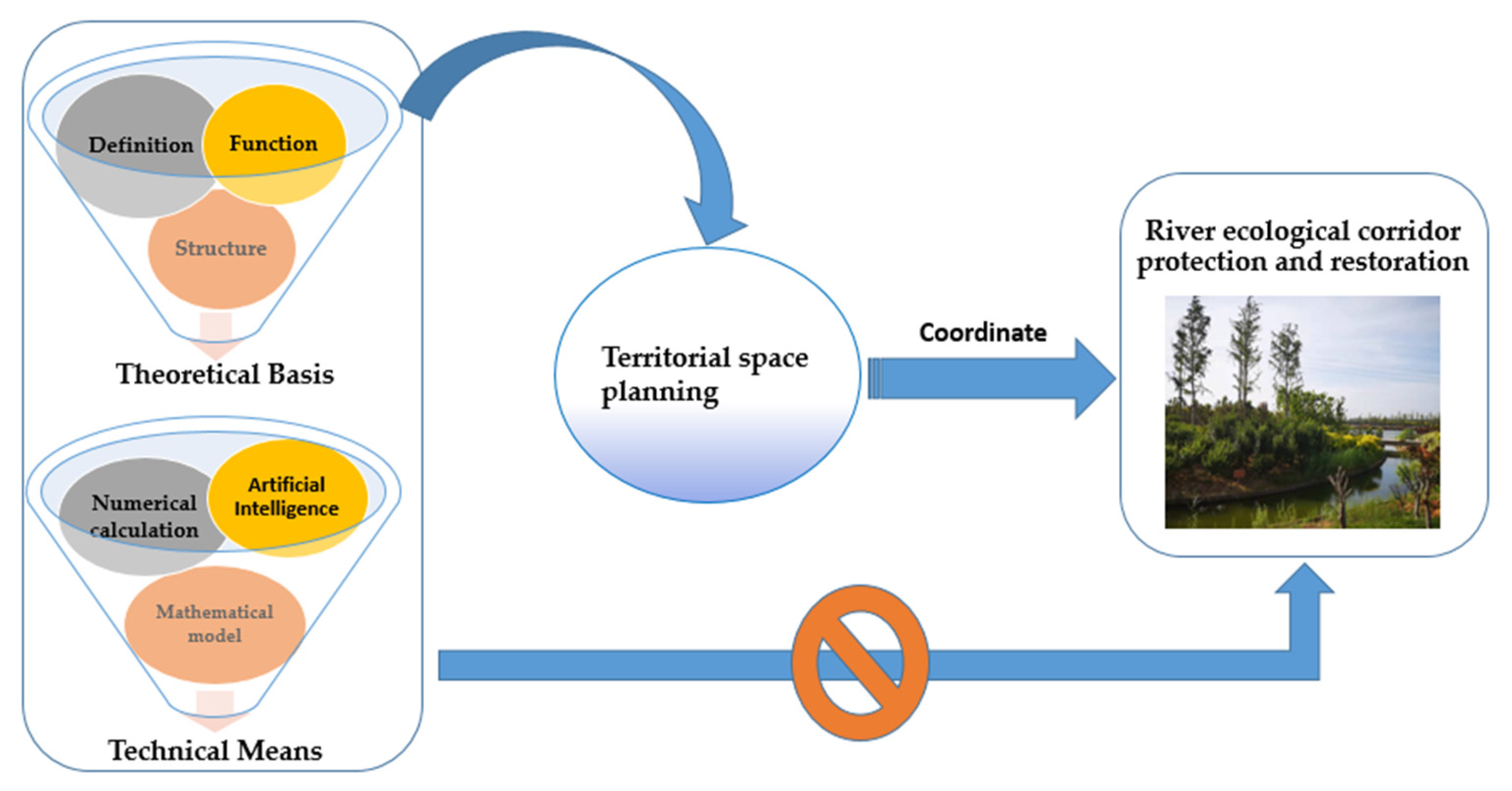
:1. Introduction
2. Theoretical Concepts and Structure
2.1. Concept Discrimination
2.1.1. Ecological Corridor
2.1.2. River Ecological Corridor
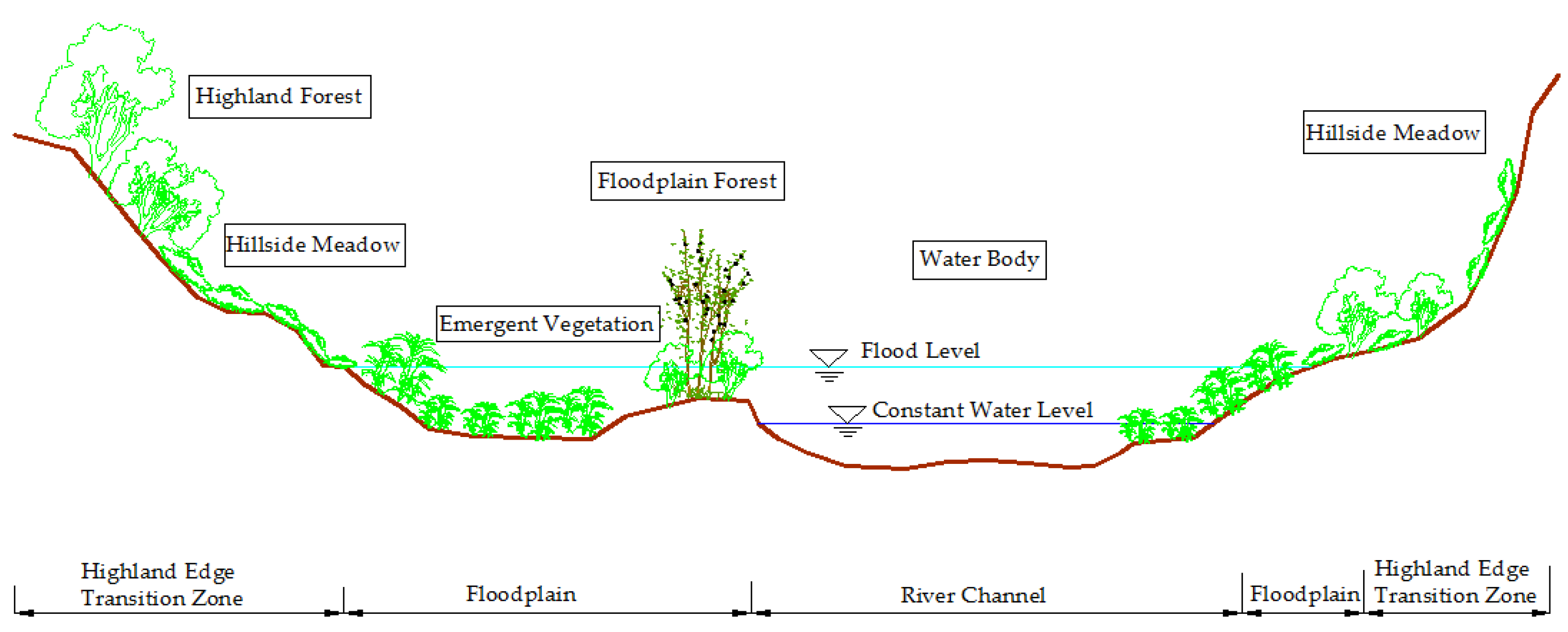
2.2. Structure and Function
2.2.1. Structure and Composition
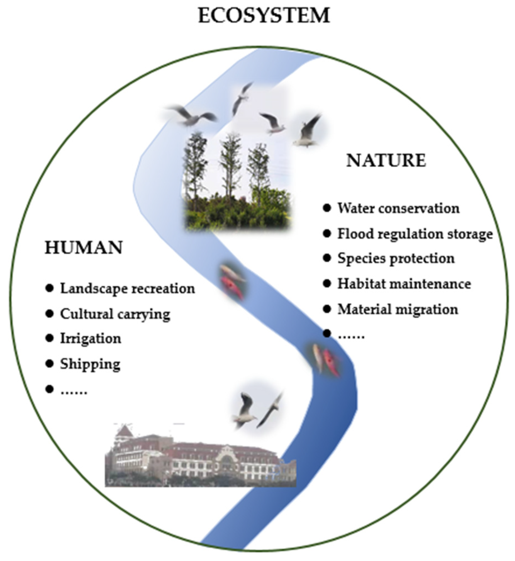
2.2.2. Function
3. The Relationship between River Ecological Corridor and Territorial Space Management and Control
3.1. River Ecological Corridor and River Shoreline
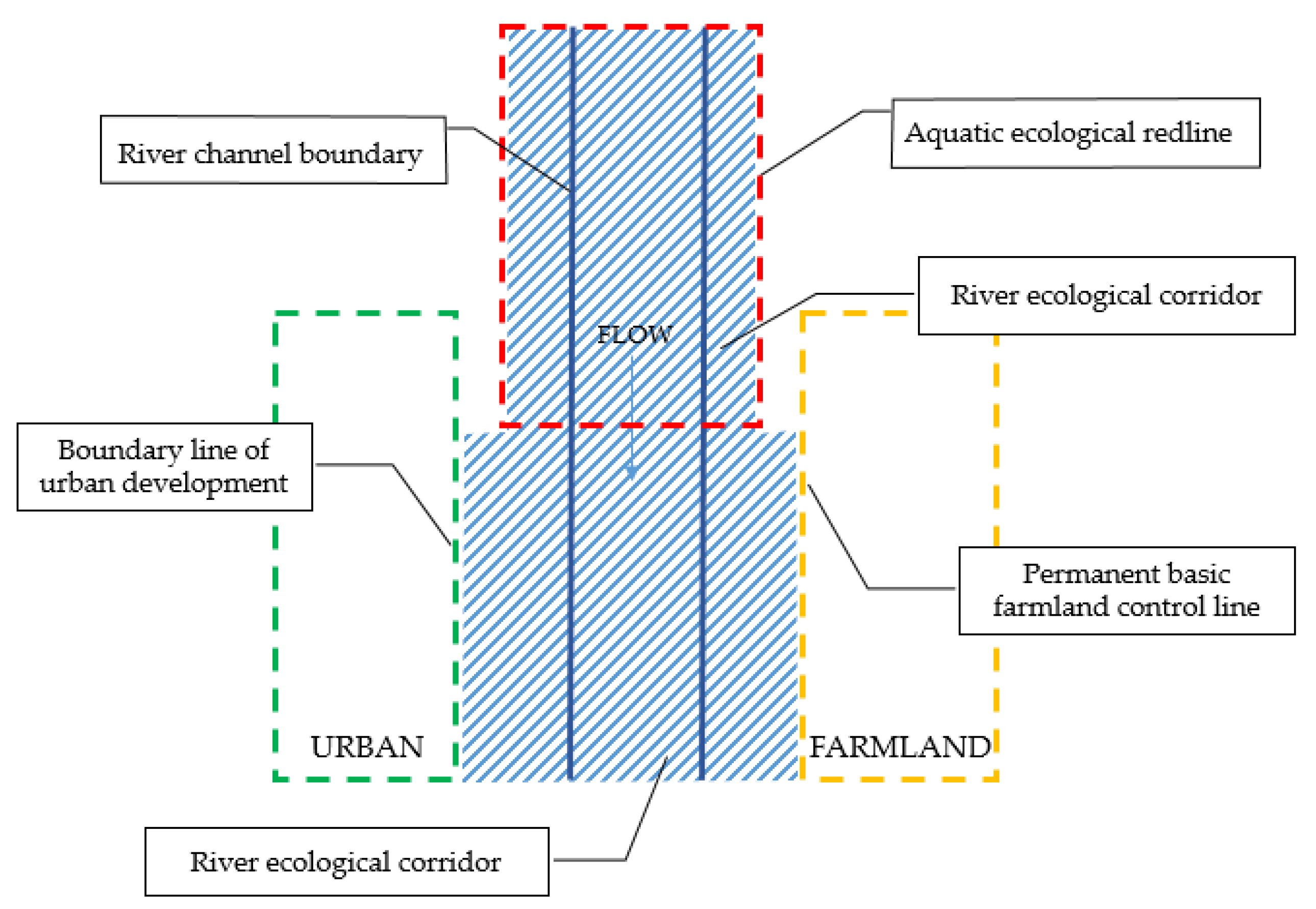
3.2. River Ecological Corridor and “Three Control Lines”
3.3. River Ecological Corridor and Other Scope Lines
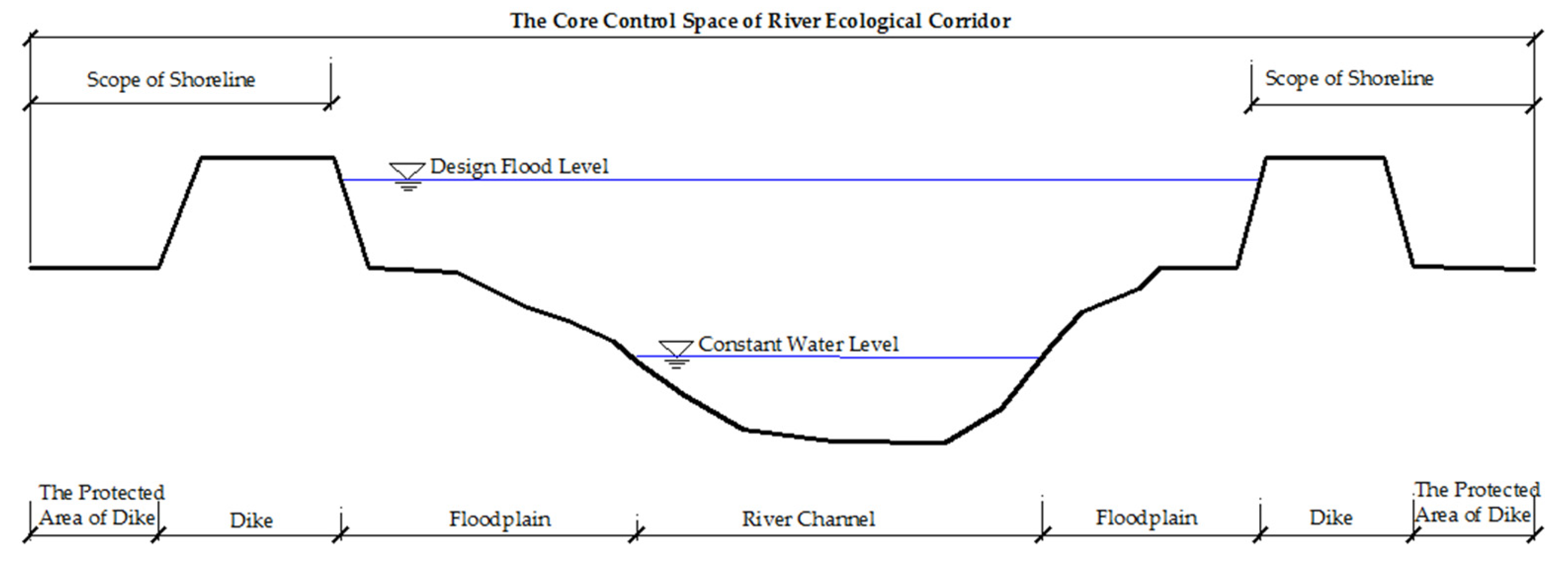
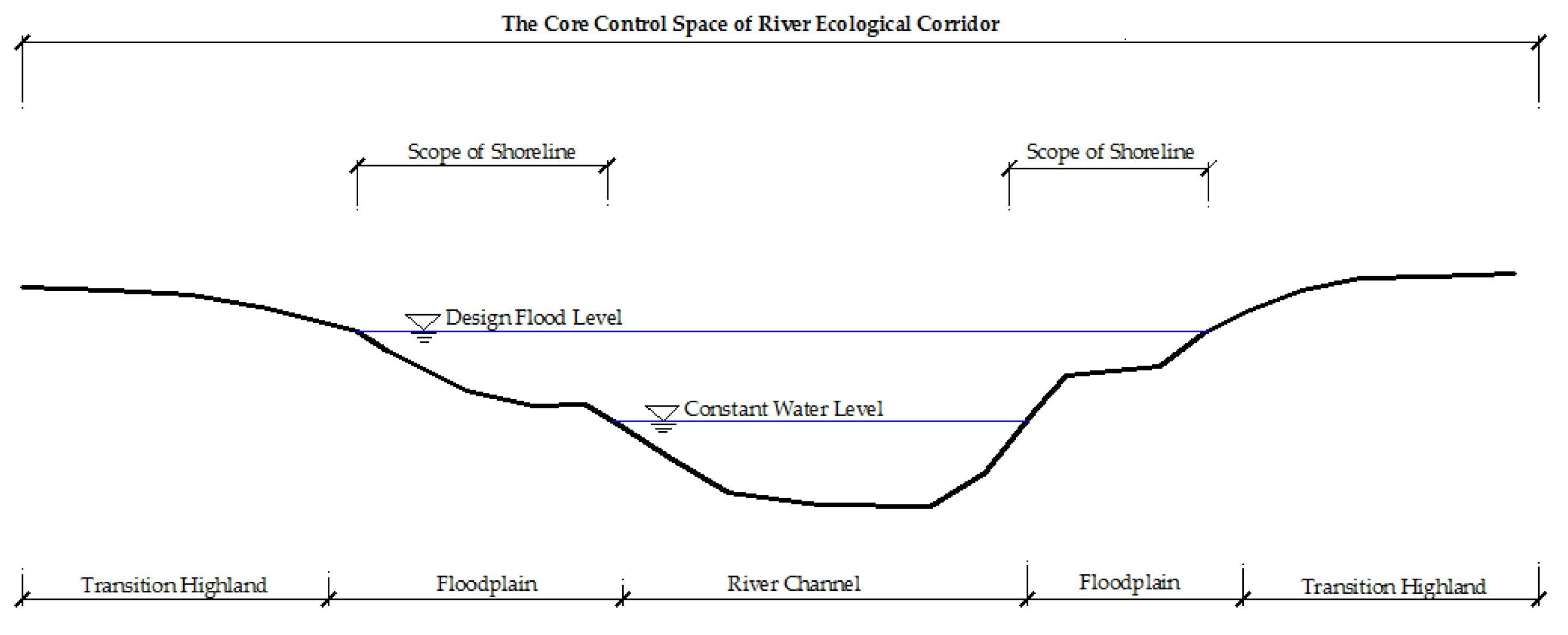
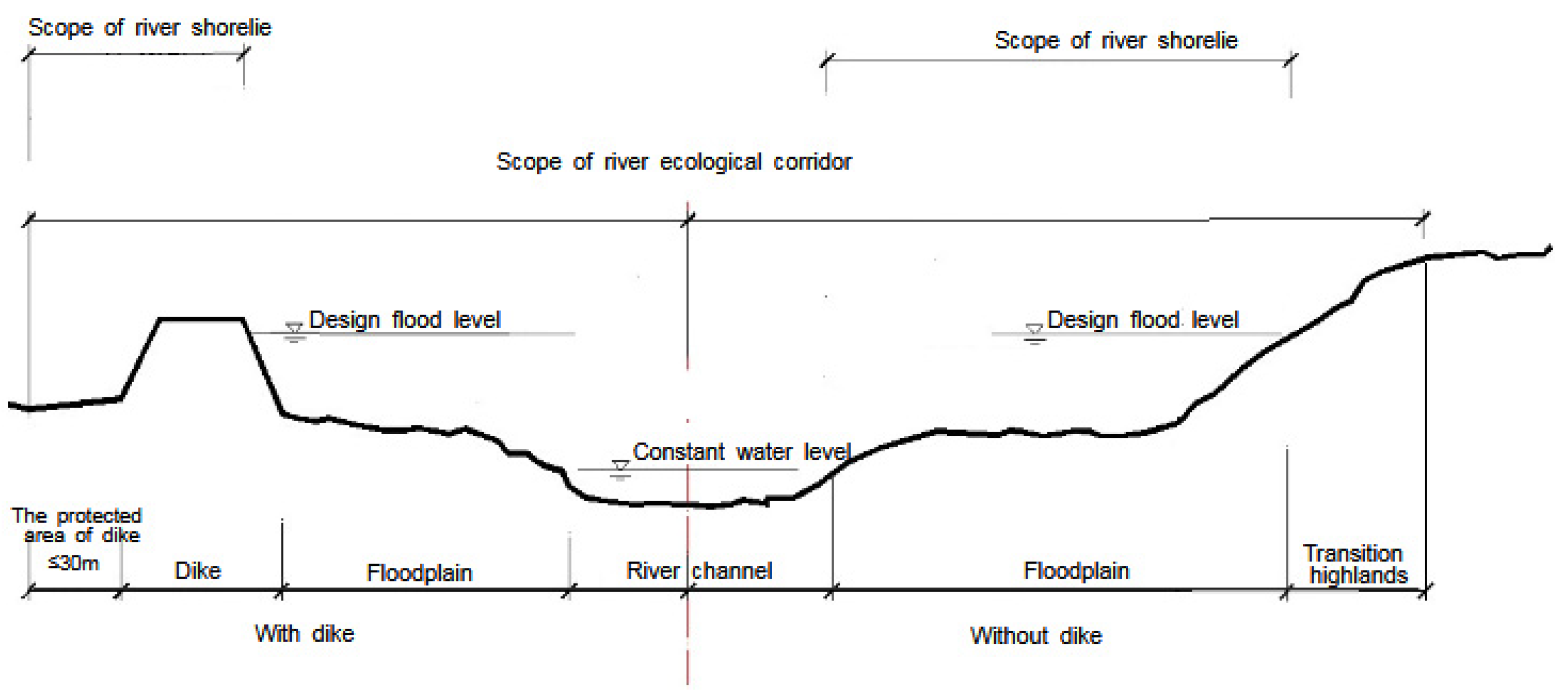
4. The Scope of River Ecological Corridor Based on Territorial Space Control
4.1. Spatial Management and Control of the River Ecological Corridor Based on Shoreline
4.2. Spatial Management and Control of the River Ecological Corridor Based on Aquatic Ecological Redline
5. Discussion
5.1. Principles for Defining the Scope of Space Management and Control
- (a)
- The principle of consistency with dominant function and restoration goals.
- (b)
- The principle of coordination with territorial spatial planning.
- (c)
- The principle of adaptation to local conditions.
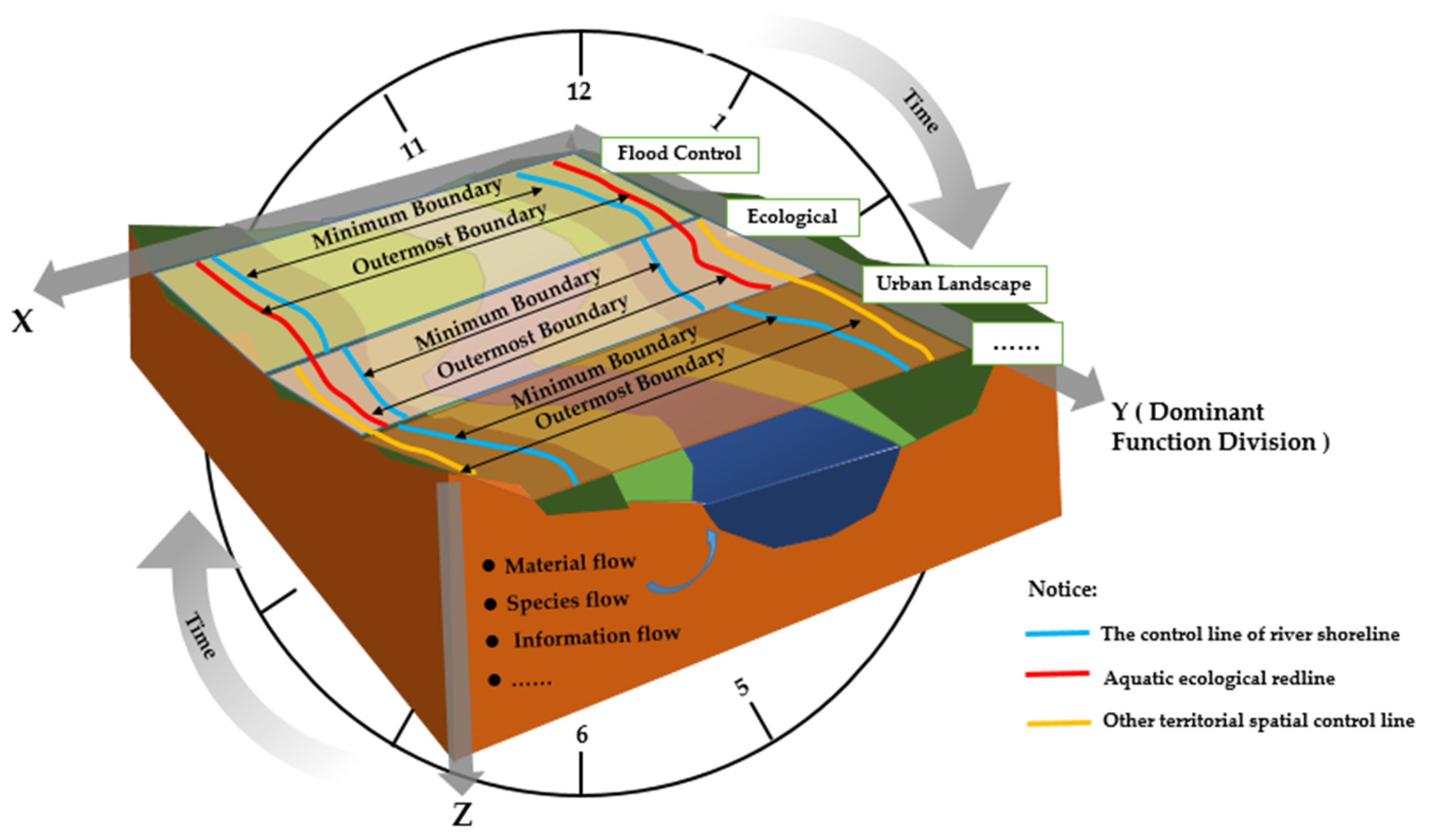
5.2. Thinking on the Determination of the River Ecological Corridor Management and Control Scope
5.3. Limitations and Future Research
- (a)
- As an important vegetation buffer zone, wildlife migration zone, biodiversity protection zone, and also as the minimum boundary in the delineation of the river ecological corridor, the transition zone of the highland edge has important research significance. Its reasonable width range needs to be studied in depth with scientific, comprehensive, and specific methods.
- (b)
- For the delineation of the ecological protection redline and aquatic ecological redline, feasible management measures and scientific demarcation methods are very necessary. The current research is not in-depth, and the delineation needs further research and exploration to truly ensure the sustainable service function of the water ecosystem.
6. Conclusions
- (a)
- What are the river ecological corridor? What functions does it include?
- (b)
- What is the territorial spatial control line? What is the relationship between it and the river ecological corridor?
- (c)
- How to define the spatial scope of the river ecological corridor? How can the research on the management and control scope of the river ecological corridor space be carried out scientifically and reasonably?
Author Contributions
Funding
Conflicts of Interest
References
- Chen, W.X.; Duan, X.J.; Zou, H. On the international experience in the large river basin’ s ecological protection and comprehensive management of waterfront resources: A case study of Rhine River. Resour. Environ. Yangtze Basin 2019, 28, 2786–2792. [Google Scholar]
- Wu, B.S.; Chen, H.G.; Ma, J.M. Review of the ecosystem restoration of Kissimmee River in USA. J. Hydraul. Eng. 2005, 36, 473–477. [Google Scholar] [CrossRef]
- Duan, H.D.; Wang, J.P.; Li, P.F. Construction concept, practice and enlightenment of foreign ecological hydraulic engineering. Water Resour. Dev. Res. 2019, 19, 64–67. [Google Scholar]
- Nakamura, F.; Ishiyama, N.; Sueyoshi, M.; Negishi, J.N.; Akasaka, T. The significance of meander restoration for the hydro-geomorphology and recovery of wetland organisms in the Kushiro River, a Lowland River in Japan. Restor. Ecol. 2014, 22, 544. [Google Scholar] [CrossRef]
- Xu, G.B.; Ren, X.F. Study on river canalization. Adv. Sci. Technol. Water Resour. 2002, 2, 17–20+70. [Google Scholar] [CrossRef]
- Song, J.L. Experience and enlightenment of multi-natural river governance in Japan. Reg. Gov. 2020, 20, 96–98. [Google Scholar] [CrossRef]
- Zhu, W.; Yang, P.; Gong, M. Japan’s multi-natural river regulation and its enlightenment to China. Water Resour. Prot. 2015, 31, 22–29. [Google Scholar] [CrossRef]
- Li, W.S.; Zhao, P. Enlightenment of ecological river management in Japan. Cheng Shi Jian She Li Lun Yan Jiu 2012, 4, 1–5. [Google Scholar]
- United States Army Corps of Engineers. Revised Definition of “Waters of the United States”. Available online: https://www.federalregister.gov/documents/2021/12/07/2021-25601/revised-definition-of-waters-of-the-united-states (accessed on 1 March 2022).
- Ministry of Water Resources. The 14th Five-Year Plan for Water Security Guarantee. Available online: http://www.gov.cn/xinwen/2022-01/12/content_5667722.htm (accessed on 15 March 2022).
- Ministry of Water Resources. Implementation Plan for Restoring the Ecological Environment of Rivers and Lakes during the 14th Five-Year Plan Period. Available online: http://www.gov.cn/xinwen/2021-12/29/content_5665150.htm (accessed on 15 March 2022).
- Standing Committee Session of the 13th National People’s Congress. Yangtze River Protection Law. Available online: http://www.gov.cn/xinwen/2020-12/27/content_5573658.htm?gov (accessed on 15 March 2022).
- Diet of Japan. The 183rd Bill Proposed by Congress. 2013. Available online: https://www.mlit.go.jp/policy/file000003.html (accessed on 2 May 2022).
- Taniguchi, M. The basic act on the water cycle with groundwater. J. Groundw. Hydrol. 2015, 57, 83–90. [Google Scholar] [CrossRef] [Green Version]
- Keller, A.A.; Cavallaro, L. Assessing the US Clean Water Act 303 (d) listing process for determining impairment of a water body. J. Environ. Manag. 2006, 86, 699–711. [Google Scholar] [CrossRef]
- Federal Ministry for the Environment. Nature Conservation and Nuclear Safety (BMUB). Draft of the General Provisions of Water Law in Germany. Urban Plan. Forum 2019, 1, 126. [Google Scholar]
- Shen, B.X.; Zheng, B.H.; Wang, H.Y.; Wang, H.Y. Research on the basic concept and the general provisions of water law in Germany. Environ. Prot. 2016, 44, 65–70. [Google Scholar] [CrossRef]
- Directive 2000/60/EC of the European Parliament and of the Council. Establishing a Framework for Community Action in the Field of Water Policy. Available online: http://data.europa.eu/eli/dir/2000/60/oj (accessed on 2 May 2022).
- Spaliviero, M. Historic fluvial development of the Alpine-foreland Tagliamento River, Italy, and consequences for floodplain management. Geomorphology 2003, 52, 317–333. [Google Scholar] [CrossRef]
- Hodges, M.F.; Krementz, D.G. Neotropical migratory breeding bird communities in riparian forests of different widths along the Altamaha River. Wilson Blletin 1996, 108, 496–506. Available online: https://www.jtor.org/stable/4163716 (accessed on 2 May 2022).
- Morrison, S.W. The Percival Creek corridor plan. J. Soil Water Conserv. 1988, 43, 465–467. [Google Scholar]
- Budd, W.W.; Cohen, P.L.; Saunders, P.R.; Steiner, F.R. Stream corridor management in the Pacific Northwest: Determination of stream corridor widths. Environ. Manag. 1987, 11, 587–597. [Google Scholar] [CrossRef]
- Peng, C.H.; Sun, Y.; Wu, Y.W.; Jiang, H. Study on determination method for riverside landscape corridor width in reducing reach of river. Des. Hydroelectr. Power Stn. 2020, 36, 66–6794. [Google Scholar] [CrossRef]
- Jayasuriya, M.T.; Stella, J.C.; Germain, R.H. Can understory plant composition and richness help designate riparian management zones in mesic headwater forests of the Northeastern United States? J. For. 2021, 119, 574–588. [Google Scholar] [CrossRef]
- Luo, K.; Cai, Y.L.; Guo, J.G.; Zuo, J.J. Landscape patterns of green stream corridors in Chong Ming Island. Resour. Environ. Yangtze Basin 2009, 18, 908–913. [Google Scholar] [CrossRef]
- Zhang, Y.B.; Wu, R.W. The theory and practice of greenway construction in Europe. Chin. Landsc. Archit. 2007, 23, 33–38. [Google Scholar]
- Voulvoulis, N.; Arpon, K.D.; Giakoumis, T. The EU water framework directive: From great expectations to problems with implementation. Sci. Total Environ. 2017, 575, 358–366. [Google Scholar] [CrossRef] [PubMed] [Green Version]
- The Ministry of Water Resources. The Guidelines for Planning of River and Lake Shoreline Protection and Utilization (Trial). Available online: http://hhs.mwr.gov.cn/axgl/201907/P020190705588813140581.pdf (accessed on 2 May 2022).
- General Office of the State Council. The Guidance on the Unified Planning and Implementation of “Three Control Lines” in Land and Space Planning. Available online: http://www.mwr.gov.cn/zw/zgzygwywj/201911/t20191101_1366794.html (accessed on 2 May 2022).
- Ministry of Housing and Urban-Rural Development. Administrative Measures for Urban Blue Line. Available online: http://www.gov.cn/gongbao/content/2006/content_453194.htm (accessed on 2 May 2022).
- Ministry of Ecological Environment. Technical Guide for Protection and Restoration of River and Lake Ecological Buffer Zone. Available online: https://www.mee.gov.cn/xxgk2018/xxgk/xxgk06/202112/W020211215541263714758.pdf (accessed on 2 May 2022).
- Forman, R.T.T.; Godron, M. Landscpae Ecology; Wiley: New York, NY, USA, 1986; pp. 121–155. [Google Scholar]
- Zhu, S.X. Construction of Ecological Corridor in the Southern Mountain Region of Jinan; Shandong Normal University: Jinan, China, 2011. [Google Scholar] [CrossRef]
- Zhu, Q.; Yu, K.J.; Li, D.H. The width of ecological corridor in landscape planning. Acta Ecol. Sin. 2005, 25, 2406–2412. [Google Scholar] [CrossRef]
- Forman, R.T.T. Land mosaic: The ecology of landscapes and regions. Camb. Univ. Press 1995, 208–252, 435–479. [Google Scholar] [CrossRef]
- Guan, W.H.; He, L.; Yao, S.M. Thoughts and strategy research of urban ecological corridor planning: Taking Nanjing as an example. Mod. Urban Res. 2007, 1, 51–58. [Google Scholar] [CrossRef]
- Ferenc, J. A reliability-theory approach to corridor design. Ecol. Model. 2000, 128, 211–220. [Google Scholar] [CrossRef]
- Da, L.J.; Chen, K.X.; Xin, Y.F. The Scale of Ecological Corridor in the Urban Forest of Shanghai. J. Northeast. For. Univ. 2004, 4, 16–18. [Google Scholar] [CrossRef]
- Turner, T. City as landscape: A post-postmodern view of design and planning. Great Br. Alden Press Oxf. 1996, 14, 183. [Google Scholar] [CrossRef]
- Décamps, H.; Naiman, R.J.; McClain, M.E. Riparian zones. In Encyclopedia of Inland Waters; Elsevier: Amsterdam, The Netherlands, 2009; pp. 396–403. [Google Scholar] [CrossRef]
- Mayer, P.M. Riparian Buffer Width, Vegetative Cover, and Nitrogen Removal Effectiveness; National Risk Management Research Laboratory, Office of Research and Development, U.S. Environmental Protection Agency: Ada, OK, USA, 2005.
- Deng, H.B.; Wang, Q.C.; Wang, Q.L.; Shao, G. On riparian forest buffers and riparian management. Chin. J. Appl. Ecol. 2001, 6, 951–954. [Google Scholar]
- Abernethy, B.; Rutherfurd, I.D. Guidelines for Stabilizing Streambanks with Riparian Vegetation. 1999. Available online: https://www.researchgate.net/publication/242217659 (accessed on 2 May 2022).
- Gregory, S.V.; Swanson, F.J.; McKee, W.A.; Cummins, K.W. An Ecosystem Perspective of Riparian Zones. BioScience 1991, 8, 540–551. [Google Scholar] [CrossRef]
- Hou, L.P.; He, P.; Qian, J.P.; Jia, J.; Xu, J. A Review on determination methods for width of riparian buffer. Wetl. Sci. 2012, 10, 500–506. [Google Scholar] [CrossRef]
- Meng, Q.B. Study on Urban Ecological Corridor Based on Biodiversity Conservation; Beijing Forestry University: Beijing, China, 2016. [Google Scholar]
- Che, S.Q. Study on the green corridors in urbanized areas. City Plan. Rev. 2001, 11, 44–48. [Google Scholar] [CrossRef]
- Li, X.G. Study on the Planning and Design of Ecological Corridor in Qingshui County of Gansu Province; Xi’an University of Architecture and Technology: Xi’an, China, 2018. [Google Scholar]
- Zhou, F.X. Preliminary studies on the planning of urban greening. Sichuan Environment. Sichuan Environ. 2004, 6, 20–22. [Google Scholar] [CrossRef]
- Xiao, H.S. Theoretical discussion on planning of urban ecological corridor. Cent. South For. Inventory Plan. 2005, 5, 15–18. [Google Scholar] [CrossRef]
- Wu, J.G. Landscape Ecology: Pattern, Process, Scale and Hierarchy; Higher Education Press: Beijing, China, 2007; Available online: https://www.researchgate.net/publication/260407842_Landscape_Ecology_Pattern_Process_Scale_and_Hierarchy (accessed on 12 May 2022).
- Dong, Z.R. Eco-Hydraulic Engineering; China Water Power Press: Beijing, China, 2019. [Google Scholar]
- Yang, N. Research and Practice on River Corridors Ecological Restoration Planning. Paper Collection of Urban Development and Planning; China City Press: Suzhou, China, 2018; p. 10. [Google Scholar]
- Cheng, C.H.; Xu, Y.Q. Study on determining method of Loudi River corridor width based on GIS. Fujian Qual. Manag. 2017, 10, 256–258. [Google Scholar] [CrossRef]
- Zhang, L. Theory and Case Study of River Corridor Planning: A Case Study of Yongning River and Jiaojiang River Corridor Planning in Taizhou, Zhejiang Province; Peking University: Beijing, China, 2004. [Google Scholar]
- Wu, H.J.; Dan, X.Q.; Huang, Y.; Liu, Y.J.; Guo, K.J. Patterns and technologies of river corridor construction in National Wetland Parks: A case study of Xiuhe National Wetland Park in Jiangxi. Wetl. Sci. Manag. 2009, 5, 34–38. [Google Scholar] [CrossRef]
- Qiang, P.P. Research on River Corridor Planning Theory and Application; Dalian University of Technology: Dalian, China, 2011. [Google Scholar]
- Brown, A.G.; Harper, D.; Peterken, G.F. European floodplain forests: Structure, functioning and management. Glob. Ecol. Biogeogr. Lett. 1997, 6, 169–178. [Google Scholar] [CrossRef]
- Patt, H.; Jürging, P.; Kraus, W. Naturnaeherer Wasserbau; Springer: Berlin, Germany, 2011; Volume 4, p. 466. [Google Scholar] [CrossRef]
- Deng, J.M.; Zhou, P. Discussions on the four-dimensional nature of river. Water Sci. Eng. Technol. 2012, 4, 16–19. [Google Scholar] [CrossRef]
- Ward, J.V. The four-dimensional nature of lotic eco-systems. J. North Am. Benthol. Soc. 1989, 8, 2–8. [Google Scholar] [CrossRef]
- Zhang, G.H. The design of the river ecological corridor based on the structural features of corridor. Ecol. Econ. 2011, 8, 184–186+189. [Google Scholar]
- Chen, X.B.; Chen, L.; Zhao, J. Hydrological connectivity between main river channel and floodplain at McCarran Ranch wetland, USA. J. Hydroelectr. Eng. 2015, 34, 100–106. [Google Scholar]
- Junk, W.J.; Bayley, P.B.; Sparks, R.E. The flood pulse concept in river-floodplain systems. Can. Spec. Publ. Fish. Aquat. Sci. 1989, 106, 110–127. Available online: https://www.researchgate.net/publication/256981220_The_Flood_Pulse_Concept_in_River-Floodplain_Systems (accessed on 12 May 2022).
- Dong, Z.R.; Zhang, J. Ecological effect of flood pulses. J. Hydraul. Eng. 2009, 40, 281–288. [Google Scholar] [CrossRef]
- Vannote, R.L. The river continuum concept. Can. J. Fish. Aquat. Sci. 1980, 37, 130–137. [Google Scholar] [CrossRef]
- Han, Q.; Zhao, J.Y.; Xu, Z.H. Study on determining the width of dynamic ecological corridor of flood river: A case study of the Langfang section of Yongding River flood plain. Water Resour. Hydropower Eng. 2020, 51, 171–180. [Google Scholar] [CrossRef]
- Li, H.Y.; Hu, T.Z. Habitat Restoration in River Corridors: Theory and Practice; China Water and Power Press: Beijing, China, 2012. [Google Scholar]
- Yin, H.W.; Kong, F.H.; Qi, Y.; Wang, J.; Zhou, Y.; Qin, Z. Developing and optimizing ecological networks in urban agglomeration of Hunan Province, China. Acta Ecol. Sin. 2011, 31, 2863–2874. [Google Scholar]
- Han, S.L. Application of Ecological Hydraulic Engineering in River Corridor Engineering. Shanxi Hydrotech. 2018, 4, 73–76+88. [Google Scholar]
- Zhao, Z.H. Research on Function Zoning of Production, Life and Ecology and Spatial Governance of Menghai Based on Major Functional Zone; Yunnan University: Kunming, China, 2016. [Google Scholar]
- Li, S.H. Analysis on uncertainty in buffer zone boundary of river wetland. Pearl River 2019, 40, 104–109. [Google Scholar] [CrossRef]
- Committee on the Dictionary of Geography. Geographical Dictionary; Shanghai Lexicographical Publishing House: Shanghai, China, 1983. [Google Scholar]
- Zhang, R.M.; Chen, X.; Zhang, X.F.; Wang, F.Q.; Wei, H.B. Current situation and current law analysis of river and lake shoreline management in China: Study on legal system construction of river and lake shoreline management, I. Water Resour. Dev. Res. 2013, 13, 28–31. [Google Scholar] [CrossRef]
- Ministry of Housing and Urban-Rural Development. Code for Plan of Urban Water System (GB50513). Available online: http://swj.sz.gov.cn/ztzl/bmzdgz/hmcsjs/zhyw/201711/P020171121629125631033.pdf (accessed on 12 May 2022).
- Zhang, R.M.; Chen, X.; Zhang, X.F. Analysis on the requirements and main ways to realize the laws and regulations of river and lake shoreline management: Study on the construction of laws and regulations of river and lake shoreline management II. Water Resour. Dev. Res. 2013, 13, 26–29. [Google Scholar] [CrossRef]
- General Office of the State Council. Several Opinions on Delimiting and Strictly Abiding by the Ecological Protection Redline. Available online: http://www.mnr.gov.cn/dt/ywbb/201810/t20181030_2285798.html (accessed on 2 May 2022).
- Yu, K.J.; Wang, C.L.; Li, D.H.; Yuan, H.; Li, W.H.; Hong, M. The concept, methodology and a case study in defining the ecological redline for the hydro-ecological space. Acta Ecol. Sin. 2019, 39, 5911–5921. [Google Scholar] [CrossRef]
- Liu, J.X. Discussion on the coordinated delineation and implementation of “third-line” territorial space planning. In China Architecture & Building Press; China City Press: Beijing, China, 2021; pp. 465–472. [Google Scholar] [CrossRef]
- Yang, Q.; Zhang, M.R.; Wang, X.H. Technical points for defining redlines and boundary of water ecological protection. China Water Resour. 2018, 18, 19–22. [Google Scholar]
- Zhang, J.Y.; Yang, Q.; Wang, X.H.; Sun, C.; Zhai, Y. Types of redlines for aquatic ecological protection and technical routes of defining. China Water Resour. 2017, 17, 6–10. [Google Scholar] [CrossRef]
- Ministry of Housing and Urban-Rural Development. Administrative Measures for Urban Green Line. Available online: http://www.gov.cn/gongbao/content/2003/content_62219.htm (accessed on 2 May 2022).
- Guo, P.P.; Qiao, X.Q.; Pei, J. Brief introduction to river bank-line and ecological protection blue line planning of river bank in Changle District of Fuzhou City. Hydraul. Sci. Technol. 2018, 18, 19–22. [Google Scholar]
- Yang, P.F.; Li, J.B. Thinking and content innovation of blue line planning under ecological orientation: A case study of Blue Line planning of Liuxi River (Conghua section) in Guangzhou. China Acad. J. Electron. Publ. House 2014, 14, 616–629. [Google Scholar]
- Duan, X.-J.; Zou, H.; Chen, W.-X.; Min, M. The concept, assessment and control zoning theory and method of waterfront resources: Taking the resources along the Yangtze River as an example. J. Nat. Resour. 2019, 34, 2209–2222. [Google Scholar] [CrossRef]
- Tan, G.M.; Yao, S.M.; Li, L.G. Key technical problems and expected achievements in efficient use and protection of the resources of river and lake shoreline and inland river marshland. Adv. Eng. Sci. 2019, 51, 1–8. [Google Scholar] [CrossRef]
- Gurnell, A.M.; Corenblit, D.; García de Jalón, D.; González del Tánago, M.; Grabowski, R.C.; O’Hare, M.T.; Szewczyk, M. A conceptual model of vegetation hydro-geomorphology interactions within river corridors. River Res. Appl. 2015, 32, 142–163. [Google Scholar] [CrossRef]
- Malanson, G.P. Riparian Landscapes; Cambridge University Press: London, UK, 1993. [Google Scholar] [CrossRef]
- Yang, N.B. Application of GIS spatial analysis in urban planning and design. Wirel. Internet Technol. 2020, 17, 162–163. [Google Scholar]
- Cai, J.; Chen, X.; Zhang, Q.C.; Xu, Q. Study on exploitation suitability and development potential of river shoreline. Yangtze River 2020, 51, 36–43. [Google Scholar] [CrossRef]
- Zheng, Z.H.; Sun, L.K.; Deng, Y.J.; Chen, D. Practice and discussion on planning of river and lake shoreline protection and utilization. J. Water Resour. Res. 2020, 9, 310–319. [Google Scholar] [CrossRef]
- Xia, J.H.; Zhou, Z.Y.; Wang, Y.; Peng, S.; Zhang, Q.; Wang, J. Planning and management for riparian lines in river chief system. Water Resour. Prot. 2017, 33, 38–41+85. [Google Scholar] [CrossRef]
- Lv, H.Y.; Li, Z.H.; Li, J.D.; Song, G.B. Research development and main method of the corridor. J. Anhui Agric. Sci. 2007, 7, 4480–4482+4484. [Google Scholar] [CrossRef]
- Wang, X.C.; Xia, X.; Lei, X. Ecological space control of Dianchi lake basin based on ecological protection red line. Econ. Geogr. 2020, 40, 191–197. [Google Scholar] [CrossRef]
- Wang, X.H.; Zhang, M.R.; Shi, X.X.; Qiu, B.; Gao, L.N. Technical methods for defining redlines for aquatic ecological protection. China Water Resour. 2017, 27, 11–15. [Google Scholar] [CrossRef]
- Opdam, P.; Steiningrover, E. Designing metropolitan landscapes for biodiversity: Deriving guidelines from metapopulation ecology. Landsc. J. 2008, 27, 69–80. [Google Scholar] [CrossRef]
- Costanza, R.; D’Arge, R.; De Groot, R.; Farber, S.; Grasso, M.; Hannon, B.; Limburg, K.; Naeem, S.; O’Neill, R.V.; Paruelo, J.; et al. The value of the world’s ecosystem services and natural capita. Nature 1997, 386, 253–260. [Google Scholar] [CrossRef]
- Mander, U.; Jagomagi, J.; Kulvik, M. Network of compensative areas as an ecological infrastructure of territories. In Proceedings of the 2nd International Seminar of the International Association for Landscape Ecology, Münstersche, Germany; 1988. [Google Scholar]
- Liu, D.; Lin, N.; Zou, C.; You, G. Development of foreign ecological protected areas and linkages to ecological protection redline delineation and management in China. Biodivers. Sci. 2015, 23, 708–715. [Google Scholar] [CrossRef] [Green Version]
- Wang, H.Z.; Liu, T.; Xu, H.; He, Y.; Liu, Y. Enlightenment of international experience on the management of China’s ecological conservation redline. Environ. Impact Assess. 2020, 42, 43–48. [Google Scholar] [CrossRef]
- Dai, Q.; Tang, H. Practice and exploration of ecological space management in highly urbanized areas: A case study of Shenzhen. Shanghai Urban Plan. Rev. 2018, 3, 13–16. [Google Scholar]
- Luo, B.L. Exploration and reflection on the control system of basic ecological control line in Wuhan. Urban Dev. Stud. 2018, 25, 43–49. [Google Scholar]
- Chi, Y.Y.; Xu, K.P.; Wang, J.J.; Zhang, L.P. Identifying regional ecological space in Beijing, Tianjin, and Hebei. Acta Ecol. Sin. 2018, 38, 8555–8563. [Google Scholar]
- Luo, Q.L.; Zhang, M.; Zhan, T.M. A review of the basic urban ecological control areas: Its concept and development. Chin. Landsc. Archit. 2016, 11, 76–81. [Google Scholar]
- Yan, C.H. A study on Spatial Governance of Key Ecology Function Area s from the Perspective of “Ecology, Production and living”, the Case of Wufeng County, Hubei Province; Central China Normal University: Wuhan, China, 2015. [Google Scholar]
- Li, M.J.; Liu, J.Z.; Li, Y.; Zhu, J.F. Ecological line control and governance in new urbanization: Zhaoqing ecological control line planning. Planners 2015, 9, 51–55. [Google Scholar]
- Forestry Administration of Guangdong Province. Planning for the Construction of an Ecological Corridor for Pearl River Delta Waterfowl. Available online: http://lyj.gd.gov.cn/attachment/0/396/396920/3045912.pdf (accessed on 12 July 2021).
- Hong, W.; Guo, R.; Su, M.; Tang, H.; Chen, L.; Hu, W. Sensitivity evaluation and land-use control of urban ecological corridors: A case study of Shenzhen, China. Land Use Policy 2017, 62, 316–325. [Google Scholar] [CrossRef]
- People’s Government of Shandong Province. Ecological Protection and High Quality Development Planning of the Yellow River Basin in Shandong Province. Available online: http://www.shandong.gov.cn/art/2022/2/15/art_107851_117497.html (accessed on 12 July 2021).
- Zhang, Z.; Liu, Y.; Li, Y.; Wang, X.; Li, H.; Yang, H.; Ding, W.; Liao, Y.; Tang, N.; He, F. Lake ecosystem health assessment using a novel hybrid decision-making framework in the Nam Co, Qinghai-Tibet Plateau. Sci. Total Environ. 2022, 808, 152087. [Google Scholar] [CrossRef]
- Zhang, Z.; Li, Y.; Wang, X.; Li, H.; Zheng, F.; Liao, Y.; Tang, N.; Chen, G.; Yang, C. Assessment of river health based on a novel multidimensional similarity cloud model in the Lhasa River, Qinghai-Tibet Plateau. J. Hydrol. 2021, 603, 127100. [Google Scholar] [CrossRef]
- Peng, J.; Zhao, H.; Liu, Y. Urban ecological corridors construction: A review. Acta Ecol. Sin. 2017, 37, 23–30. [Google Scholar] [CrossRef]
- Jarosaw, T.C.; Winiewski, P. River valleys as ecological corridors—Structure, function and importance in the conservation of natural resources. Ecol. Quest. 2018, 29, 77–87. [Google Scholar] [CrossRef] [Green Version]
- Toccolini, A.; Fumagalli, N.; Senes, G. Greenways planning in Italy: The Lambro River Valley Greenways System. Landsc. Urban Plan 2006, 7, 98–111. [Google Scholar] [CrossRef]
- Yunus, A.; Nakagoshi, N.; Ibrahim, A.L. Riparian land-use and land cover change analysis using GIS in Pinang river watershed, Malaysia. Tropics 2004, 13, 235–248. [Google Scholar] [CrossRef]
- Gregory, A.; Spence, E.; Beier, P.; Garding, E. Toward Best Management Practices for Ecological Corridors. Land 2021, 10, 140. [Google Scholar] [CrossRef]


| Nationality | Release Time | Name | Remarks |
|---|---|---|---|
| Japan | 1997 | Fluvial Law | The system of water control, water conservancy, and water environment are integrated, and the territorial development plan is considered to ensure the comprehensive management of rivers [13]. |
| 2014 | The Basic Act on the Water Cycle | The management of river basins is carried out on a basin-by-basin and in a manner of comprehensive regional sovereignty. Efforts are made to restore the original appearance and the ecosystem [14]. | |
| USA | 1972 (Amended in 1977) | The Clean Water Act | Tanking “restoring and maintaining chemistry, physics and biological integrity in national waters” is the legal goal [15]. |
| 2019 | Federal Register | Redefine the waters, terminate the jurisdiction of the “transient” rivers, and emphasize the impact of hydraulic engineering on the ecology [9]. | |
| China | 2021 | The 14th Five-Year Plan for Water Security Guarantee | The management of river and lake space should be strengthened to promote the protection and restoration of river shorelines, and the construction of the ecological corridor [10]. |
| 2021 | The Yangtze River Protection Law | The protection of the Yangtze River Basin must be strengthened, and the protection plan for river and lake shorelines must also be formulated [12]. | |
| Germany | 2009 (Amended in 2013) | The General Provisions of Water Law | In order to protect water sources from adverse effects, water protection areas should be determined, flood areas should be protected, and natural landscapes should be maintained and regained [16]. |
| 2018 | Urban Nature Master Plan- Federal Government’s “Vibrant City” Action Plan | The water body and its flood plains are protected to maintain water quality and habitat. Creating a more tranquil and healthy environment to improve the quality of life [17]. | |
| European Union | 2002 (Amended in 2014) | Water Framework Directive | Watershed management areas and plans should be determined to effectively manage the water environment [18]. |
| Nationality/Department | Basis for Scope Definition | Angle of Consideration | Existing Problems | |||||
|---|---|---|---|---|---|---|---|---|
| Habitat Maintenance | Regulating Flood | Landscape Entertainment | Social Services | Territorial Regulation | ||||
| Foreign | Japan | Administrative boundary [14] | √ | √ | √ | √ | “Transboundary water” problem | |
| USA | Navigable waters [9] | √ | √ | √ | √ | The precise problem of boundaries | ||
| European Union | Watershed management area [27] | √ | √ | √ | √ | The management of land and water | ||
| China | Ministry of Water Resources | River shoreline management scope [28] | √ | Multisectoral coordination problem | ||||
| Bureau of Land and Resources | “Three control lines” [29]/Urban blue line [30] | √ | √ | √ | ||||
| Ministry of Ecological Environment | Ecological buffer zone [31] | √ | √ | √ | ||||
| Related Concepts | Foundation | Relationship with the Scope of the River Ecological Corridor |
|---|---|---|
| Urban blue line | Administrative Measures for Urban Blue Line | The blue line is structurally included in the scope of the river shoreline and is the reference line when delimiting the scope of the river ecological corridor. |
| The riparian ecological blue line | Local laws and regulations | |
| Urban green line | Administrative Measures for Urban Green Line | In terms of structure, the green line is much larger than the river shoreline. It contributes less to the territorial spatial control line such as the aquatic ecological redline. But it still needs to be used as a reference line to delimit the scope of the river ecological corridor when necessary. |
Publisher’s Note: MDPI stays neutral with regard to jurisdictional claims in published maps and institutional affiliations. |
© 2022 by the authors. Licensee MDPI, Basel, Switzerland. This article is an open access article distributed under the terms and conditions of the Creative Commons Attribution (CC BY) license (https://creativecommons.org/licenses/by/4.0/).
Share and Cite
Han, Q.; Wang, X.; Li, Y.; Zhang, Z. River Ecological Corridor: A Conceptual Framework and Review of the Spatial Management Scope. Int. J. Environ. Res. Public Health 2022, 19, 7752. https://doi.org/10.3390/ijerph19137752
Han Q, Wang X, Li Y, Zhang Z. River Ecological Corridor: A Conceptual Framework and Review of the Spatial Management Scope. International Journal of Environmental Research and Public Health. 2022; 19(13):7752. https://doi.org/10.3390/ijerph19137752
Chicago/Turabian StyleHan, Qi, Xiaogang Wang, Yun Li, and Zhengxian Zhang. 2022. "River Ecological Corridor: A Conceptual Framework and Review of the Spatial Management Scope" International Journal of Environmental Research and Public Health 19, no. 13: 7752. https://doi.org/10.3390/ijerph19137752