Estimating the Responses of Hydrological and Sedimental Processes to Future Climate Change in Watersheds with Different Landscapes in the Yellow River Basin, China

Abstract
:1. Introduction
2. Materials and Methods
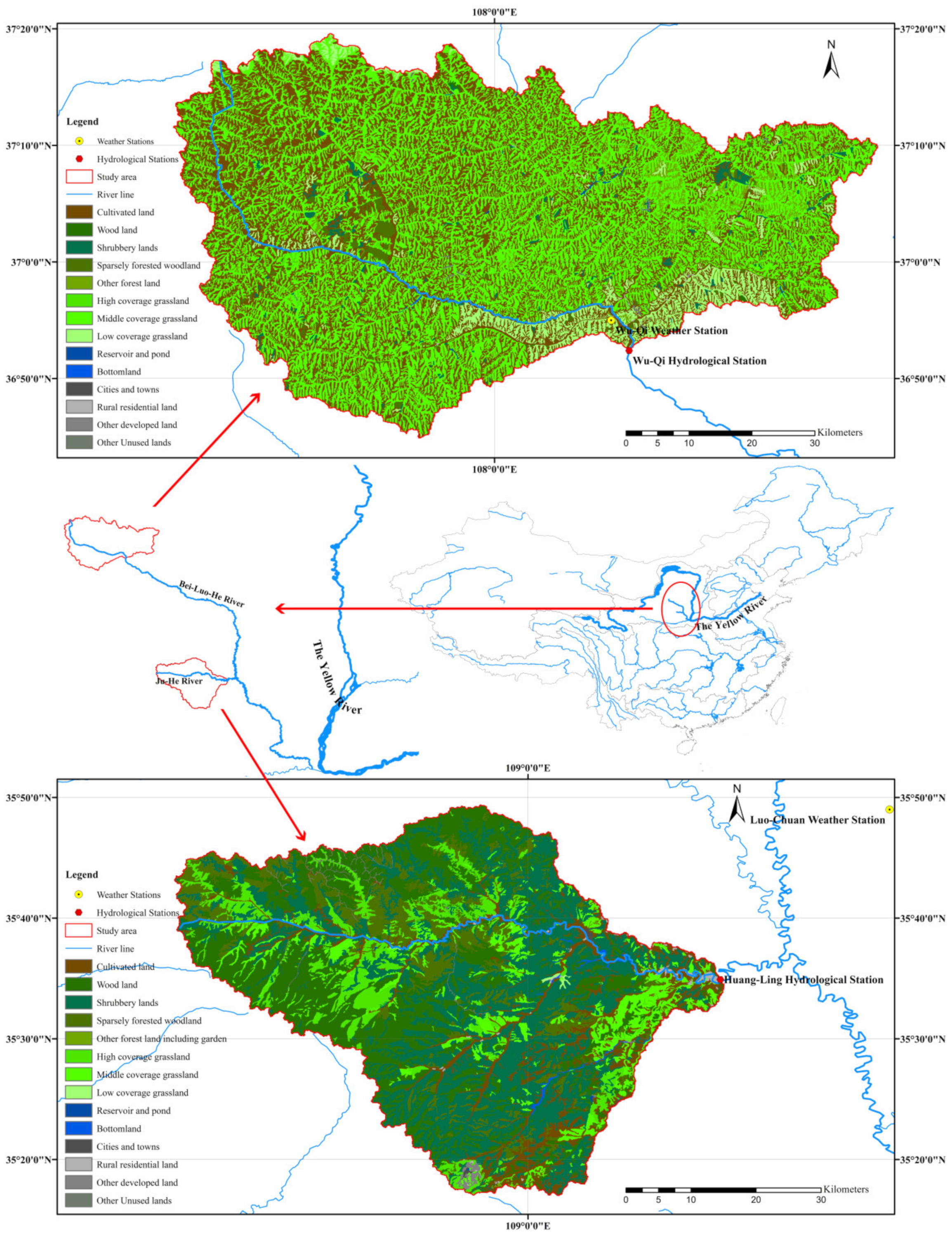
2.1. Study Area and Data Source
2.2. Application of the GWLF
2.3. Application of the LARS-WG
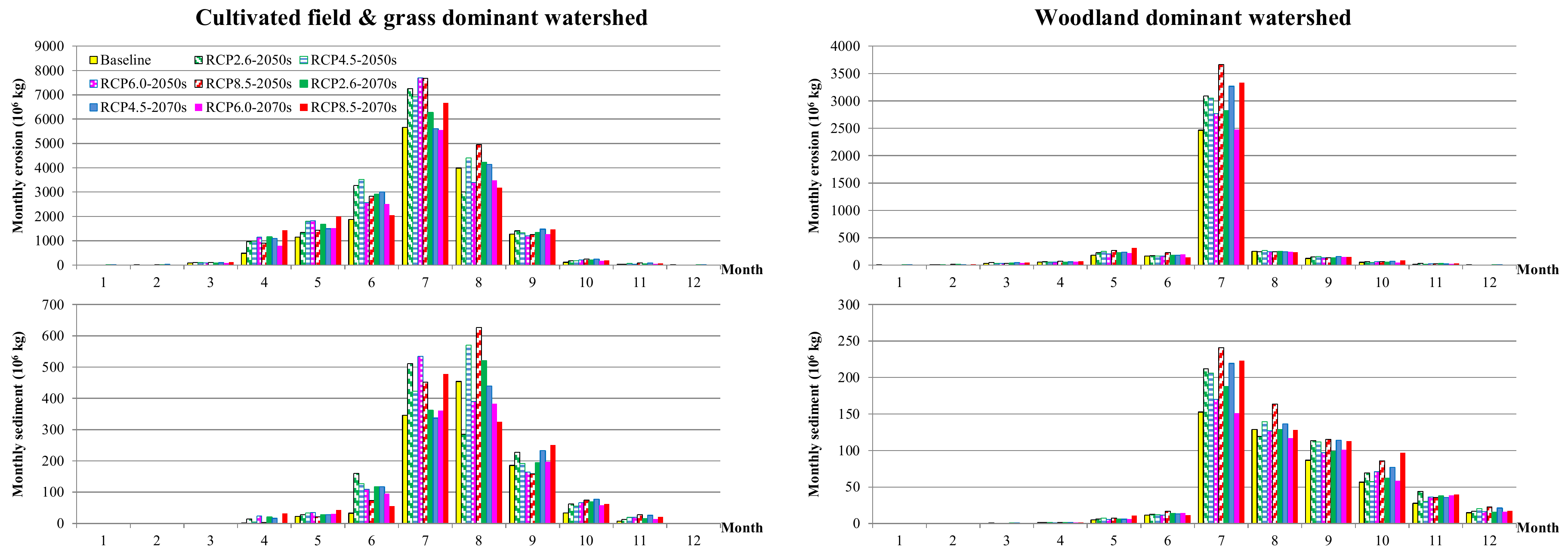
3. Results
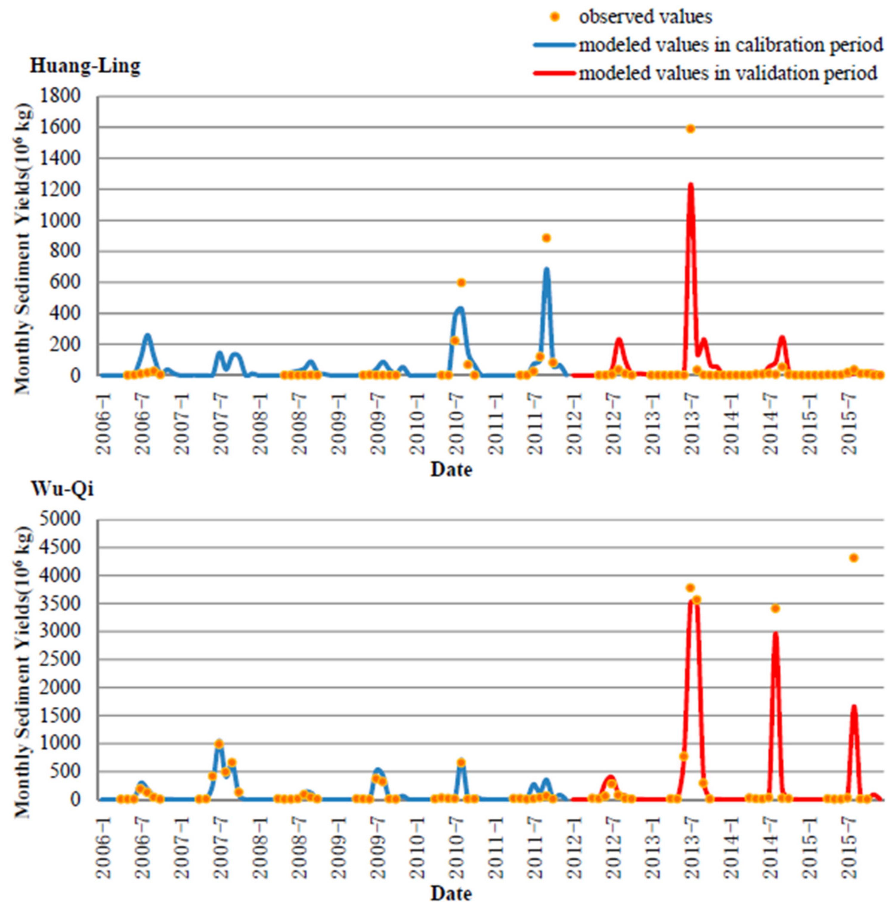
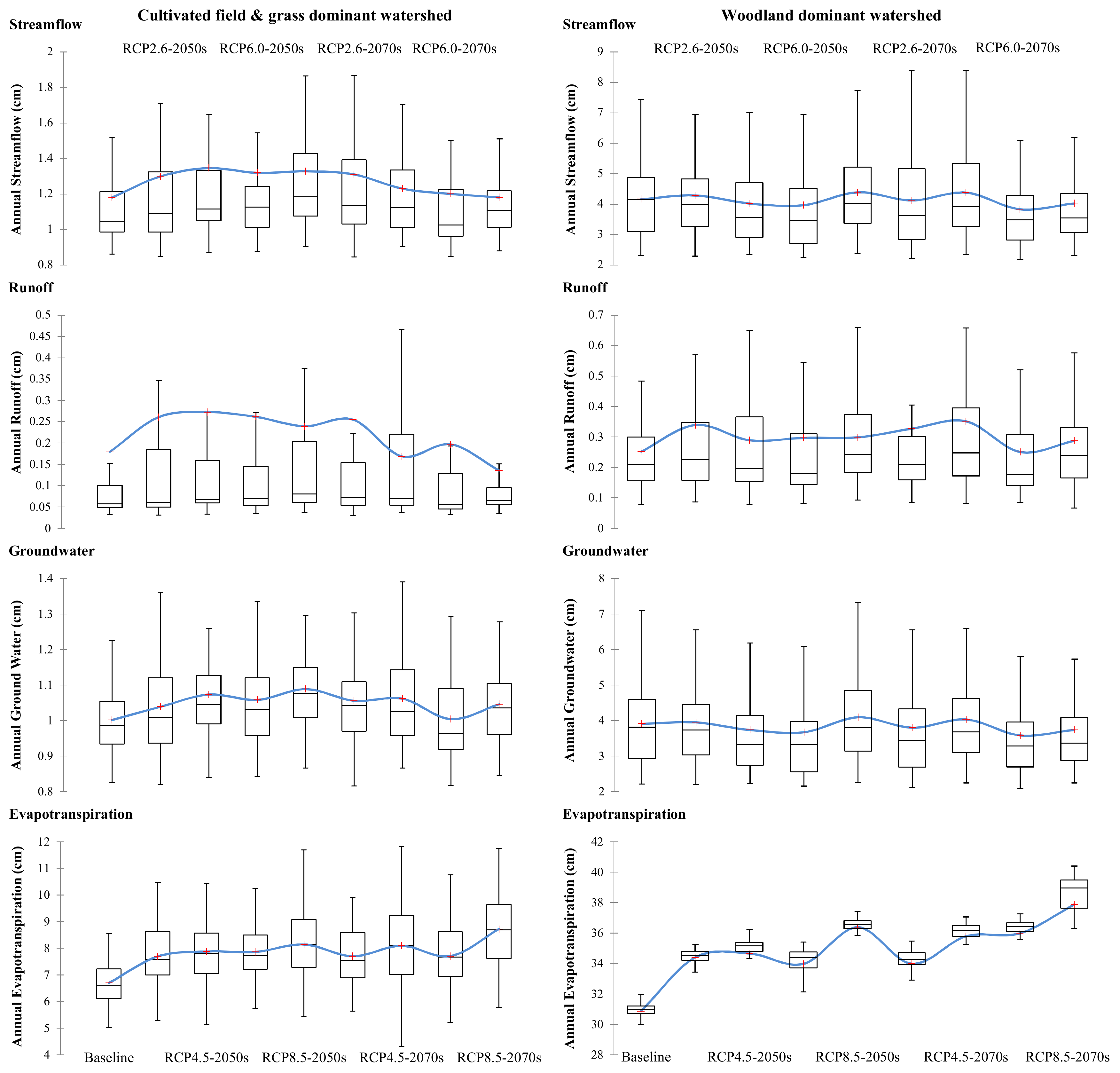
3.1. GWLF Model
3.2. The LARS-WG Model
4. Discussion
4.1. Comparison of Responses in Hydrological Processes
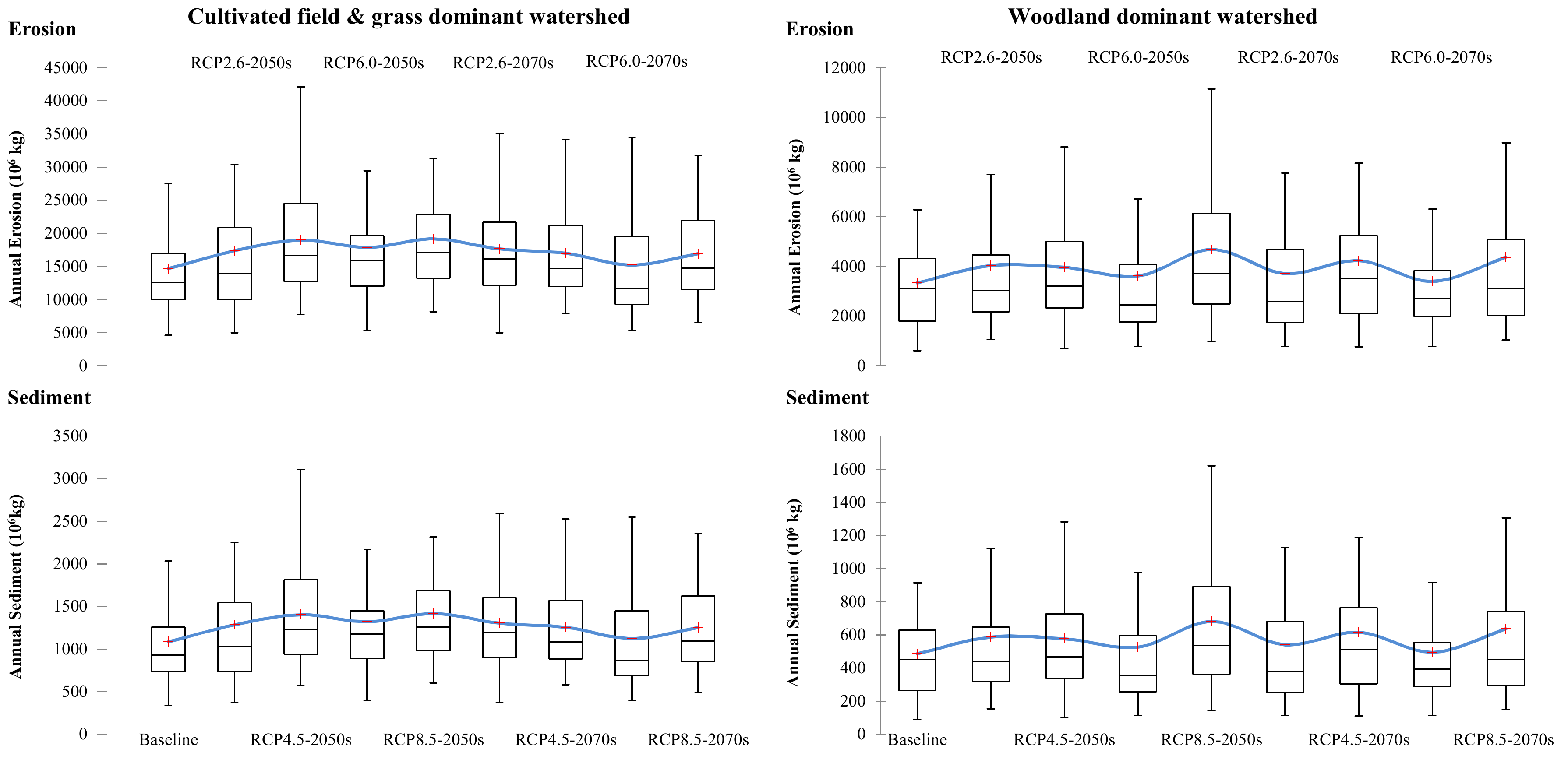
4.2. Comparison of Responses on Sedimental Processes
5. Conclusions
- (1)
- There was a hotter and wetter trend of climate change in the study area. The amount of streamflow in CGM would increase firstly and then decrease, with the peak level appearing in the 2050s under the scenario of RCP 4.5. The changes in streamflow in WW were generally negative due to intense evapotranspiration in hot weather conditions, which could offset the increased precipitation. The runoff in both CGM and WW would increase in the 2050s, which is conducive to sediment delivery.
- (2)
- There were increasing trends of erosion and sediment yields in both CGM and WW under all climate change scenarios. The woodland represented greater resistance stability than cultivated field, with a lesser increment in sediment in hotter and wetter weather conditions. The sediment yields in both CGM and WW would reach their peak in the 2050s in the near future, indicating urgent demands for sediment control.
- (3)
- There is great demand for effective management measures to address the impacts of future climate change on sediment yields. The strategy of increasing woodland areas is one of the most effective approaches, such as through policies of afforestation and returning farmland to forests. Without essential land use conversion, various soil conservation measures should be implemented in cultivated land to reduce erosion yields, including conservation tillage, cover crops, crop rotations, contour farming and terraces, etc. In addition, a series of installations that could block the delivery of sediment from erosion should be constructed, such as vegetable buffers, man-made drainage courses and wetlands.
- (4)
- The approach of integrated multi-model applications used in this study showed great ability to quantitatively estimate the responses of hydrological and sedimental processes to future climate change in the Yellow River Basin and may also be applicable in other areas with similar conditions.
Supplementary Materials
Author Contributions
Funding
Acknowledgments
Conflicts of Interest
References
- Darby, S.E.; Hackney, C.R.; Leyland, J.; Kummu, M.; Lauri, H.; Parsons, D.R.; Best, J.L.; Nicholas, A.P.; Aalto, R. Fluvial sediment supply to a mega-delta reduced by shifting tropical-cyclone activity. Nature 2016, 539, 276. [Google Scholar] [CrossRef] [PubMed]
- Li, Z.; Xu, X.; Yu, B.; Xu, C.; Liu, M.; Wang, K. Quantifying the impacts of climate and human activities on water and sediment discharge in a karst region of southwest china. J. Hydrol. 2016, 542, 836–849. [Google Scholar] [CrossRef]
- Rodríguez-Blanco, M.L.; Arias, R.; Taboada-Castro, M.M.; Nunes, J.P.; Keizer, J.J.; Taboada-Castro, M.T. Potential impact of climate change on suspended sediment yield in nw spain: A case study on the corbeira catchment. Water 2016, 8, 444. [Google Scholar] [CrossRef]
- Khoi, D.N.; Suetsugi, T. Impact of climate and land-use changes on hydrological processes and sediment yield—A case study of the be river catchment, vietnam. Hydrol. Sci. J. 2014, 59, 1095–1108. [Google Scholar] [CrossRef]
- Liu, L.; Guo, Z.; Huang, G.; Wang, R. Water productivity evaluation under multi-gcm projections of climate change in oases of the heihe river basin, northwest china. Int. J. Environ. Res. Public Health 2019, 16, 1706. [Google Scholar] [CrossRef]
- Olaka, L.A.; Ogutu, J.O.; Said, M.Y.; Oludhe, C. Projected climatic and hydrologic changes to lake victoria basin rivers under three rcp emission scenarios for 2015–2100 and impacts on the water sector. Water 2019, 11, 1449. [Google Scholar] [CrossRef]
- Bussi, G.; Dadson, S.J.; Prudhomme, C.; Whitehead, P.G. Modelling the future impacts of climate and land-use change on suspended sediment transport in the river thames (uk). J. Hydrol. 2016, 542, 357–372. [Google Scholar] [CrossRef]
- Shrestha, B.; Babel, M.S.; Maskey, S.; van Griensven, A.; Uhlenbrook, S.; Green, A.; Akkharath, I. Impact of climate change on sediment yield in the mekong river basin: A case study of the nam ou basin, lao pdr. Hydrol. Earth Syst. Sci. 2013, 17, 1–20. [Google Scholar] [CrossRef]
- Gericke, A.; Kiesel, J.; Deumlich, D.; Venohr, M. Recent and future changes in rainfall erosivity and implications for the soil erosion risk in brandenburg, ne germany. Water 2019, 11, 904. [Google Scholar] [CrossRef]
- Shrestha, N.K.; Wang, J. Predicting sediment yield and transport dynamics of a cold climate region watershed in changing climate. Sci. Total Environ. 2018, 625, 1030–1045. [Google Scholar] [CrossRef]
- Zhang, S.; Li, Z.; Hou, X.; Yi, Y. Impacts on watershed-scale runoff and sediment yield resulting from synergetic changes in climate and vegetation. Catena 2019, 179, 129–138. [Google Scholar] [CrossRef]
- Hovenga, P.A.; Wang, D.; Medeiros, S.C.; Hagen, S.C.; Alizad, K. The response of runoff and sediment loading in the apalachicola river, florida to climate and land use land cover change. Earth’s Future 2016, 4, 124–142. [Google Scholar] [CrossRef]
- Stern, M.; Flint, L.; Minear, J.; Flint, A.; Wright, S. Characterizing changes in streamflow and sediment supply in the sacramento river basin, california, using hydrological simulation program—Fortran (hspf). Water 2016, 8, 432. [Google Scholar] [CrossRef]
- Zhao, Y.; Zou, X.; Liu, Q.; Yao, Y.; Li, Y.; Wu, X.; Wang, C.; Yu, W.; Wang, T. Assessing natural and anthropogenic influences on water discharge and sediment load in the yangtze river, china. Sci. Total Environ. 2017, 607–608, 920–932. [Google Scholar] [CrossRef]
- Wang, S.; Fu, B.; Liang, W.; Liu, Y.; Wang, Y. Driving forces of changes in the water and sediment relationship in the yellow river. Sci. Total Environ. 2017, 576, 453–461. [Google Scholar] [CrossRef]
- Wang, X.; Engel, B.; Yuan, X.; Yuan, P. Variation analysis of streamflows from 1956 to 2016 along the yellow river, china. Water 2018, 10, 1231. [Google Scholar] [CrossRef]
- Wang, G.; Wu, B.; Wang, Z.-Y. Sedimentation problems and management strategies of sanmenxia reservoir, yellow river, china. Water Resour. Res. 2005, 41. [Google Scholar] [CrossRef]
- Zhang, L.-T.; Li, Z.-B.; Wang, S.-S. Spatial scale effect on sediment dynamics in basin-wide floods within a typical agro-watershed: A case study in the hilly loess region of the chinese loess plateau. Sci. Total Environ. 2016, 572, 476–486. [Google Scholar] [CrossRef]
- Piao, S.; Ciais, P.; Huang, Y.; Shen, Z.; Peng, S.; Li, J.; Zhou, L.; Liu, H.; Ma, Y.; Ding, Y.; et al. The impacts of climate change on water resources and agriculture in china. Nature 2010, 467, 43. [Google Scholar] [CrossRef]
- Yang, X.; Sun, W.; Li, P.; Mu, X.; Gao, P.; Zhao, G. Reduced sediment transport in the chinese loess plateau due to climate change and human activities. Sci. Total Environ. 2018, 642, 591–600. [Google Scholar] [CrossRef]
- Haith, D.A.; Shoemaker, L.L. Generalized watershed loading functions for stream flow nutrients. J. Am. Water Resour. Assoc. 1987, 23, 471–478. [Google Scholar] [CrossRef]
- Hong, B.; Limburg, K.E.; Hall, M.H.; Mountrakis, G.; Groffman, P.M.; Hyde, K.; Luo, L.; Kelly, V.R.; Myers, S.J. An integrated monitoring/modeling framework for assessing human–nature interactions in urbanizing watersheds: Wappinger and onondaga creek watersheds, new york, USA. Environ. Model. Softw. 2012, 32, 1–15. [Google Scholar] [CrossRef]
- Schneiderman, E.M.; Pierson, D.C.; Lounsbury, D.G.; Zion, M.S. Modeling the hydrochemistry of the cannonsville watershed with generalized watershed loading functions (gwlf). J. Am. Water Resour. Assoc. 2002, 38, 1323–1347. [Google Scholar] [CrossRef]
- Sha, J.; Swaney, D.P.; Hong, B.; Wang, J.; Wang, Y.; Wang, Z.-L. Estimation of watershed hydrologic processes in arid conditions with a modified watershed model. J. Hydrol. 2014, 519, 3550–3556. [Google Scholar] [CrossRef]
- Wu, C.-D.; Cheng, C.-C.; Lo, H.-C.; Chen, Y.-K. Application of sebal and markov models for future stream flow simulation through remote sensing. Water Resour. Manag. 2010, 24, 3773–3797. [Google Scholar] [CrossRef]
- Semenov, M.A.; Barrow, E.M. Use of a stochastic weather generator in the development of climate change scenarios. Clim. Chang. 1997, 35, 397–414. [Google Scholar] [CrossRef]
- Semenov, M.A.; Stratonovitch, P. Use of multi-model ensembles from global climate models for assessment of climate change impacts. Clim. Res. 2010, 41, 1–14. [Google Scholar] [CrossRef] [Green Version]
- Hashmi, M.Z.; Shamseldin, A.Y.; Melville, B.W. Comparison of sdsm and lars-wg for simulation and downscaling of extreme precipitation events in a watershed. Stoch. Environ. Res. Risk Assess. 2011, 25, 475–484. [Google Scholar] [CrossRef]
- Khan, M.S.; Coulibaly, P.; Dibike, Y. Uncertainty analysis of statistical downscaling methods. J. Hydrol. 2006, 319, 357–382. [Google Scholar] [CrossRef]
- Farajzadeh, M.; Oji, R.; Cannon, A.J.; Ghavidel, Y.; Massah Bavani, A. An evaluation of single-site statistical downscaling techniques in terms of indices of climate extremes for the midwest of iran. Theor. Appl. Climatol. 2015, 120, 377–390. [Google Scholar] [CrossRef]
- Khorshidi, M.S.; Nikoo, M.R.; Sadegh, M.; Nematollahi, B. A multi-objective risk-based game theoretic approach to reservoir operation policy in potential future drought condition. Water Resour. Manag. 2019, 33, 1999–2014. [Google Scholar] [CrossRef]
- Awal, R.; Fares, A.; Bayabil, H. Assessing potential climate change impacts on irrigation requirements of major crops in the brazos headwaters basin, texas. Water 2018, 10, 1610. [Google Scholar] [CrossRef]
- Hijmans, R.J.; Cameron, S.E.; Parra, J.L.; Jones, P.G.; Jarvis, A. Very high resolution interpolated climate surfaces for global land areas. Int. J. Climatol. 2005, 25, 1965–1978. [Google Scholar] [CrossRef]
- Sha, J.; Li, X.; Wang, Z.-L. Estimation of future climate change in cold weather areas with the lars-wg model under cmip5 scenarios. Theor. Appl. Climatol. 2019, 137, 3027–3039. [Google Scholar] [CrossRef]
- Naderi, M.; Raeisi, E. Climate change in a region with altitude differences and with precipitation from various sources, south-central iran. Theor. Appl. Climatol. 2016, 124, 529–540. [Google Scholar] [CrossRef]
- Vallam, P.; Qin, X.S. Projecting future precipitation and temperature at sites with diverse climate through multiple statistical downscaling schemes. Theor. Appl. Climatol. 2018, 134, 669–688. [Google Scholar] [CrossRef]
- Sha, J.; Wang, Z.-L.; Zhao, Y.; Xu, Y.-X.; Li, X. Estimation of hydrological response to future climate change in a cold watershed. J. Water Clim. Chang. 2018, 10, 78–88. [Google Scholar] [CrossRef]


| Name | Source | Resolution | Remark |
|---|---|---|---|
| Digital Elevation Model | Geospatial Data Cloud site, Computer Network Information Center, Chinese Academy of Sciences. (http://www.gscloud.cn) | 30 m × 30 m raster | Advanced Spaceborne Thermal Emission and Reflection Radiometer Global Digital Elevation Model Version 2 (ASTER GDEM V2) |
| Land Use Cover Maps | Data Center for Resources and Environmental Sciences, Chinese Academy of Sciences (RESDC) (http://www.resdc.cn) | 30 m × 30 m raster | 2015 |
| Weather Data | Climatic Data Center, National Meteorological Information Center, China Meteorological Administration (http://data.cma.cn) | Daily temperature and precipitation | 1957–2016 |
| River Flow Records | Annual Hydrological Report P.R. China (National Library of China) | Monthly mean rate of flow | 2006–2015 |
| Sediment Records | National Earth System Science Data Sharing Infrastructure, National Science and Technology Infrastructure of China (http://www.geodata.cn) | Monthly mean sediment concentration in flow | 2006–2015 |
| Abbreviation | Full Name |
|---|---|
| BCC-CSM1-1 | Beijing Climate Center Climate System Model version 1.1 |
| CCSM4 | Community Climate System Model Version 4 |
| GISS-E2-R | Russell Ocean Model of NASA Goddard Institute for Space Studies |
| HadGEM2-AO | Hadley Centre Global Environmental Model version 2, Atmosphere-Ocean |
| HadGEM2-ES | Hadley Centre Global Environmental Model version 2, Earth System |
| IPSL-CM5A-LR | The Low-Resolution Version of Institut Pierre Simon Laplace Earth System Model for the Coupled Model Project Phase 5 |
| MIROC-ESM-CHEM | Atmospheric Chemistry Coupled Earth System Model of Model for Interdisciplinary Research on Climate |
| MIROC-ESM | Earth System Model of Model for Interdisciplinary Research on Climate |
| MIROC5 | Model for Interdisciplinary Research on Climate Version Five |
| MRI-CGCM3 | Meteorological Research Institute Coupled Global Climate Model Version 3 |
| NorESM1-M | The Norwegian Climate Center’s Earth System Model |
| Items | Total Tests | Number of Significant Differences | Percentage of Significant Differences (%) | ||
|---|---|---|---|---|---|
| Luo-Chuan | Wu-Qi | Luo-Chuan | Wu-Qi | ||
| WDSeries a | 8 | 0 | 1 | 0 | 12.5 |
| PrecD b | 12 | 0 | 0 | 0 | 0 |
| PMM c | 12 | 0 | 0 | 0 | 0 |
| PMV d | 12 | 1 | 1 | 8.3 | 8.3 |
| TminD e | 12 | 0 | 0 | 0 | 0 |
| TminM f | 12 | 1 | 0 | 8.3 | 0 |
| TmaxD g | 12 | 0 | 0 | 0 | 0 |
| TmaxM h | 12 | 0 | 0 | 0 | 0 |
© 2019 by the authors. Licensee MDPI, Basel, Switzerland. This article is an open access article distributed under the terms and conditions of the Creative Commons Attribution (CC BY) license (http://creativecommons.org/licenses/by/4.0/).
Share and Cite
Li, X.; Sha, J.; Zhao, Y.; Wang, Z.-L. Estimating the Responses of Hydrological and Sedimental Processes to Future Climate Change in Watersheds with Different Landscapes in the Yellow River Basin, China. Int. J. Environ. Res. Public Health 2019, 16, 4054. https://doi.org/10.3390/ijerph16204054
Li X, Sha J, Zhao Y, Wang Z-L. Estimating the Responses of Hydrological and Sedimental Processes to Future Climate Change in Watersheds with Different Landscapes in the Yellow River Basin, China. International Journal of Environmental Research and Public Health. 2019; 16(20):4054. https://doi.org/10.3390/ijerph16204054
Chicago/Turabian StyleLi, Xue, Jian Sha, Yue Zhao, and Zhong-Liang Wang. 2019. "Estimating the Responses of Hydrological and Sedimental Processes to Future Climate Change in Watersheds with Different Landscapes in the Yellow River Basin, China" International Journal of Environmental Research and Public Health 16, no. 20: 4054. https://doi.org/10.3390/ijerph16204054