
An Intelligent Compaction Analyzer: A Versatile Platform for Real-Time Recording, Monitoring, and Analyzing of Road Material Compaction


Abstract
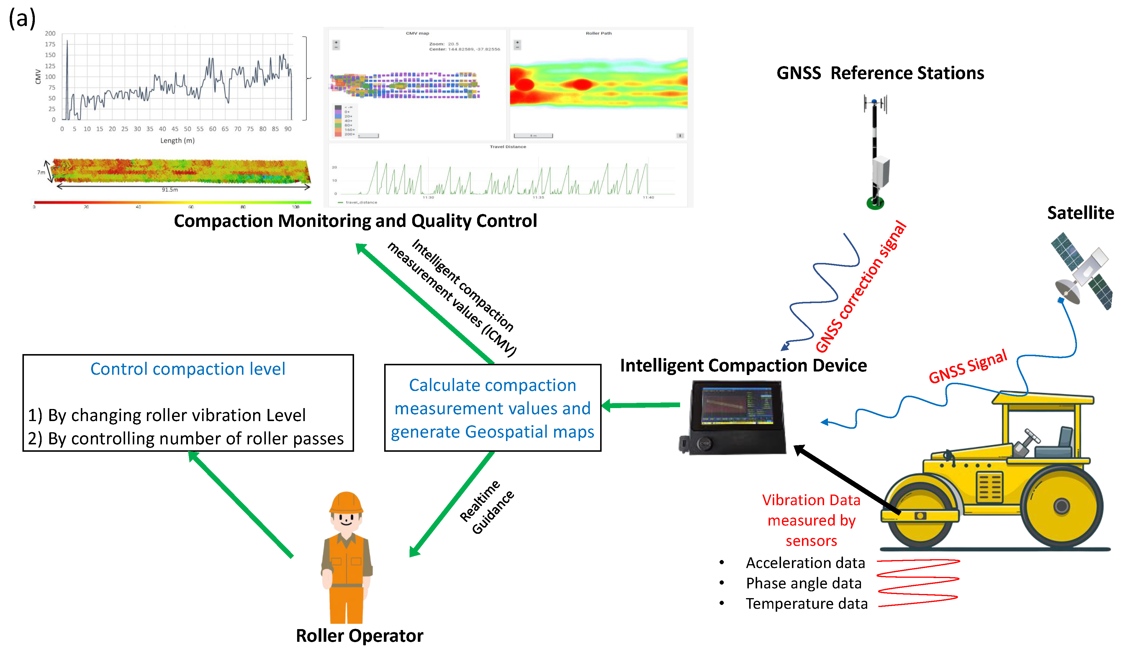
:1. Introduction
- Phase angle measurement of response vibration through the cross-correlation of dual axis acceleration signals: The compaction meters come with OEM rollers that utilize hall effect phase angle sensors that measure the movement of the eccentric mass mounted within the rotary drum of the compaction roller. The current retrofit devices lack the ability to calculate stiffness-based ICMVs as a phase angle sensor is non-retrofittable to a conventional roller. However, with the implementation of cross-correlation for dual-axis vibration measurement, the ICA platform is able to measure stiffness-based parameters (i.e., [2] and [21]) while remaining retrofit-friendly.
- A well-defined signal processing system: Through a process of trial and error, we identified the most suitable noise reduction algorithms and data sampling rates for the application of the ICA platform, such as the use of Hann Smoothing for noise reduction.
- The use of signal distortion measurement: We implemented the experimental algorithm called ‘MFD (modified fundamental distortion)’ to measure the distortion level of the excitation vibration force.
- The use of an autonomous vehicle grade GNSS system: The existing compaction measurement systems are equipped with survey-grade GNSS systems that were known to be slow in providing high-accuracy positional data, and they require bulkier GNSS antennas. However, the ICA platform leverages state-of-the-art GNSS technology [22] that can provide faster and more accurate positional data.
- Raw vibration signal visualization and data saving: While sophisticated compaction measurement calculation methods exist for extracting data from raw vibration signals, there are instances when it is beneficial to simply monitor the raw vibration data in real time and analyze it using fast Fourier transform (FFT). However, to the best of the authors’ knowledge, no existing compaction measurement systems offer this capability.
- Independent software analytic tools and cloud-based data storage and analysis: The ICA platform is equipped with its own compaction analysis page, and it has the capability to stream live data to the AWS (Amazon Web Services) cloud for storage and further analysis, which eliminates the need for a third-party software or physically copying data to a computer.
2. Materials and Methods
2.1. Hardware Development
2.2. Data Processing Pipeline
- The Hann window tapers the data to zero at both ends, which is vital for accelerometer data. This tapering minimizes the abrupt transitions at the start and end of the signal segment, which can introduce unwanted high-frequency components [48].
- The Hann window finds an optimal balance when capturing frequency data. This balance ensures that the resulting frequency spectrum is neither smeared (losing resolution) nor riddled with spurious peaks (due to leakage) [49].
- When we compare it to other methods like Hamming or Blackman, the Hann window is a good choice. It works well for data with short, sudden spikes, like the data from accelerometers.

2.2.1. Calculation of Compaction Measurement Parameters
2.2.2. Geolocation of Data
2.3. Software Development
Software Functionality
2.4. Data Recording and Streaming
3. Results
3.1. The ICA Platform
3.2. Field Demonstration Results
- Non-uniform compaction areas: The ICMV maps can identify non-uniform compaction areas in the material layer, which may be caused by variations in the material properties, layer thickness, or roller passes. These areas may require additional compaction to achieve the desired compaction quality. In Figure 4a,b, the and values are irregular and the and maps show non-uniformity. However, in Figure 4c,d the and values are consistent and uniform for the same compaction area, which highlights the existence of a poor correlation between current ICMVs used in practice.
- Comparison with historical data: The ICMV maps can also be used to compare the current compaction results with historical data to track the progress of the compaction over time. This can help the roller operator to make adjustments to the compaction parameters to achieve the desired compaction quality as per the design specifications.
- Correlation with compaction quality: The ICMV maps are useful to evaluate the quality of the compaction of the material layer. By comparing the ICMV values with the design specifications, the operator can identify the areas that require additional compaction to achieve the desired density or stiffness.
- Verification of roller coverage (or roller pass count map): The ICMV maps can also be used to verify the coverage of the roller passes over the compacted area. These maps should show a consistent distribution of roller passes across the entire compaction area. The areas with low ICMVs may indicate insufficient compaction.
4. Discussion
Future Works
Supplementary Materials
Author Contributions
Funding
Data Availability Statement
Acknowledgments
Conflicts of Interest
Abbreviations
| CCV | Compaction control value |
| CMV | Compaction meter value |
| CPU | Central processing unit |
| DAQ | Data acquisition |
| DFT | Discrete Fourier transform |
| GPR | Ground penetrating radar |
| GPU | Graphics processing unit |
| GNSS | Global navigation system |
| HDMI | High-definition multimedia interface |
| HPA | Horizontal position accuracy |
| IEPE | Integrated electronics Piezo-electric |
| IC | Intelligent compaction |
| ICA | Intelligent compaction analyzer |
| ICM | Intelligent compaction meter |
| ICMV | Intelligent compaction measurement values |
| IR | Infrared |
| SKb | Stiffness |
| LGPL | Lesser general public license |
| MFD | Modified fundamental distortion |
| NTRIP | Networked transport of RTCM via internet protocol |
| PCB | Printed circuit board |
| PPM | Pixels per meter |
| RAM | Random access memory |
| ROI | Region of interest |
| RTK | Real-time kinematic |
| RTCM | Radio technical commission for maritime |
| SBC | Single-board computer |
| SEvib | SPARC vibratory modulus |
| SSID | Service set identifier |
| SSS | Solid-state storage |
| THD | Total harmonic distortion |
| UI | User interfaces |
| USB | Universal serial bus |
| VNC | Virtual network computing |
Appendix A

| Library | Description/Purpose | License |
|---|---|---|
| PySide2 | GUI library used for interface development | Lesser general public license (LGPL) |
| PyQtGraph | Graphics library used for developing visualization tools | MIT license (MIT) |
| Numpy | Array library used for 2D pixel array manipulation | BSD license (BSD) |
| Pillow | Image manipulation | Historical permission notice and disclaimer (HPND) |
| SciPy | Mathematical functions library | BSD license (BSD) |
| Matplotlib | Visualization library used here for color maps | Python software foundation license (PSF) |
| pynmea2 | Library for parsing NMEA sentences | MIT license (MIT) |
| daqhats | Drivers for MCC172 DAQ | NA |
| ads1015 | Reading analog data | MIT license (MIT) |
| Pickle | Saving and opening byte data | Python software foundation license (PSF) |
References
- International Society for Intelligent Construction—ISIC. Intelligent Compaction. 2017. Available online: https://www.is-ic.org/library/intelligent-compaction/ (accessed on 12 July 2021).
- Anderegg, R.; Kaufmann, K. Intelligent compaction with vibratory rollers: Feedback control systems in automatic compaction and compaction control. Transp. Res. Rec. 2004, 1868, 124–134. [Google Scholar] [CrossRef]
- Hu, W.; Huang, B.; Shu, X.; Woods, M. Utilising intelligent compaction meter values to evaluate construction quality of asphalt pavement layers. Road Mater. Pavement Des. 2017, 18, 980–991. [Google Scholar] [CrossRef]
- Zhu, X.; Bai, S.; Xue, G.; Yang, J.; Cai, Y.; Hu, W.; Jia, X.; Huang, B. Assessment of compaction quality of multi-layer pavement structure based on intelligent compaction technology. Constr. Build. Mater. 2018, 161, 316–329. [Google Scholar] [CrossRef]
- Hu, W.; Jia, X.; Zhu, X.; Gong, H.; Xue, G.; Huang, B. Investigating key factors of intelligent compaction for asphalt paving: A comparative case study. Constr. Build. Mater. 2019, 229, 116876. [Google Scholar] [CrossRef]
- Cai, H.; Kuczek, T.; Dunston, P.S.; Li, S. Correlating intelligent compaction data to in situ soil compaction quality measurements. J. Constr. Eng. Manag. 2017, 143, 04017038. [Google Scholar] [CrossRef]
- Fathi, A.; Tirado, C.; Rocha, S.; Mazari, M.; Nazarian, S. Assessing depth of influence of intelligent compaction rollers by integrating laboratory testing and field measurements. Transp. Geotech. 2021, 28, 100509. [Google Scholar] [CrossRef]
- Suthakaran, S.; Sounthararajah, A.; Ghorbani, J.; Bodin, D.; Kodikara, J. A state-of-the-art review of compaction control test methods and intelligent compaction technology for asphalt pavements. Road Mater. Pavement Des. 2021, 24, 1–30. [Google Scholar] [CrossRef]
- Gutiérrez, V.; Theodoridis, E.; Mylonas, G.; Shi, F.; Adeel, U.; Diez, L.; Amaxilatis, D.; Choque, J.; Camprodom, G.; McCann, J.; et al. Co-creating the cities of the future. Sensors 2016, 16, 1971. [Google Scholar] [CrossRef]
- Doscher, J.; Evangelist, M. Accelerometer design and applications. Analog Devices 1998, 3, 16. [Google Scholar]
- Levinzon, F. Piezoelectric Accelerometers with Integral Electronics; Springer: Berlin/Heidelberg, Germany, 2015. [Google Scholar]
- Ning, B.; Wu, Y. Research on non-contact infrared temperature measurement. In Proceedings of the 2010 IEEE International Conference on Computational Intelligence and Software Engineering, Wuhan, China, 10–12 December 2010; pp. 1–4. [Google Scholar] [CrossRef]
- Marques, G.; Pitarma, R. Non-contact infrared temperature acquisition system based on Internet of things for laboratory activities monitoring. Procedia Comput. Sci. 2019, 155, 487–494. [Google Scholar] [CrossRef]
- Compaction Control for Soil Compactors. Trimble Civil Engineering and Construction. 2021. Available online: https://heavyindustry.trimble.com/en/products/compaction-control-soil-compactors (accessed on 28 January 2022).
- TOPCON. C-53 Intelligent Compaction. 2023. Available online: https://www.topconpositioning.com/machine-control/compactors/c-53-intelligent-compaction (accessed on 18 January 2022).
- BOMAG. BOMAG Compaction Management—BCM 05. 2023. Available online: https://www.bomag.com/ww-en/technologies/overview/bomag-compaction-management/ (accessed on 20 January 2022).
- Cat Compact Technology. CAT. 2023. Available online: https://www.cat.com/en_US/by-industry/construction-industry-resources/technology/compact.html (accessed on 19 January 2022).
- HAMM. HAMM Compaction Quality—HCQ. 2023. Available online: https://www.wirtgen-group.com/en-au/products/hamm/technologies/hcq-hamm-compaction-quality/ (accessed on 20 January 2022).
- SAKAI Intelligent Compaction System. 2023. SAKAI. Available online: https://www.sakainet.co.jp/en/ (accessed on 19 January 2022).
- Sullivan, D.R.; Rahman, M.A.; Gerard, B.; Hobson, K.R.; Zaman, M. Intelligent Compaction Data Analyzing Final Report. ResearchGate. 2018. Available online: https://www.researchgate.net/profile/Mohammad-Rahman-73/publication/334675732_INTELLIGENT_COMPACTION_DATA_ANALYZING/links/600b650ba6fdccdcb872e2d6/INTELLIGENT-COMPACTION-DATA-ANALYZING.pdf (accessed on 12 July 2021).
- Krober, W.; FLOSS, E.R.; Wallrath, W. Dynamic soil stiffness as quality criterion for soil compaction. In Geotechnics for Roads, Rail Tracks and Earth Structures; A A Balkema Publishers: Lisse, The Netherlands, 2001; pp. 189–199. [Google Scholar]
- ZED-F9R module. Ublox. 2022. Available online: https://www.u-blox.com/en/product/zed-f9r-module (accessed on 3 March 2022).
- Basford, P.J.; Johnston, S.J.; Perkins, C.S.; Garnock-Jones, T.; Tso, F.P.; Pezaros, D.; Mullins, R.D.; Yoneki, E.; Singer, J.; Cox, S.J. Performance analysis of single-board computer clusters. Future Gener. Comput. Syst. 2020, 102, 278–291. [Google Scholar] [CrossRef]
- Prabhu, G.R.D.; Yang, T.H.; Hsu, C.Y.; Shih, C.P.; Chang, C.M.; Liao, P.H.; Ni, H.T.; Urban, P.L. Facilitating chemical and biochemical experiments with electronic microcontrollers and single-board computers. Nat. Protoc. 2020, 15, 925–990. [Google Scholar] [CrossRef] [PubMed]
- Peiris, H.A.; Ranasinghe, R.G.; Peiris, T.D. Alternative Platform for Vision based Robot Navigation. Int. J. Eng. Technol. 2018, 7, 26–30. [Google Scholar]
- Johnston, S.J.; Basford, P.J.; Perkins, C.S.; Herry, H.; Tso, F.P.; Pezaros, D.; Mullins, R.D.; Yoneki, E.; Cox, S.J.; Singer, J. Commodity single-board computer clusters and their applications. Future Gener. Comput. Syst. 2018, 89, 201–212. [Google Scholar] [CrossRef]
- Cressey, D. The DIY electronics transforming research. Nature 2017, 544, 125–126. [Google Scholar] [CrossRef]
- Kozlov, D.V.; Stepanov, A.B. The Main features of a multichannel continuous wavelet transform implementation on the Nvidia Jetson single-board computers. In Proceedings of the 2021 IEEE Conference of Russian Young Researchers in Electrical and Electronic Engineering (ElConRus), Moscow, Russia, 26–29 January 2021; pp. 1632–1636. [Google Scholar] [CrossRef]
- Alexey, G.; Klyachin, V.; Eldar, K.; Driaba, A. Autonomous mobile robot with AI based on Jetson Nano. In Proceedings of the Future Technologies Conference, Vancouver, BC, Canada, 5–6 November 2020; Springer: Berlin/Heidelberg, Germany, 2020; pp. 190–204. [Google Scholar] [CrossRef]
- Podbucki, K.; Marciniak, T. Aspects of autonomous drive control using NVIDIA Jetson Nano microcomputer. In Proceedings of the 2022 IEEE 17th Conference on Computer Science and Intelligence Systems (FedCSIS), Sofia, Bulgaria, 4–7 September 2022; pp. 117–120. [Google Scholar] [CrossRef]
- Jetson Nano Developer Kit. Nvidia Developer. 2022. Available online: https://developer.nvidia.com/embedded/jetson-nano-developer-kit (accessed on 11 March 2022).
- Nguyen, H.Q.; Loan, T.T.K.; Mao, B.D.; Huh, E.N. Low cost real-time system monitoring using Raspberry Pi. In Proceedings of the 2015 IEEE Seventh International Conference on Ubiquitous and Future Networks, Sapporo, Japan, 7–10 July 2015; pp. 857–859. [Google Scholar] [CrossRef]
- Pajankar, A. Introduction to single-board computers and Raspberry Pi. In Raspberry Pi Supercomputing and Scientific Programming: MPI4PY, NumPy, and SciPy for Enthusiasts; Apress: Berkeley, CA, USA, 2017; pp. 1–25. [Google Scholar] [CrossRef]
- Mathe, S.E.; Pamarthy, A.C.; Kondaveeti, H.K.; Vappangi, S. A review on raspberry pi and its robotic applications. In Proceedings of the 2022 IEEE 2nd International Conference on Artificial Intelligence and Signal Processing (AISP), Vijayawada, India, 12–14 February 2022; pp. 1–6. [Google Scholar] [CrossRef]
- Raspberry Pi 4 Model B. Raspberry Pi. 2022. Available online: https://www.raspberrypi.com/products/raspberry-pi-4-model-b/ (accessed on 20 July 2021).
- MCC 172. Measurement Computing Corporation. 2022. Available online: https://www.mccdaq.com/DAQ-HAT/MCC-172.aspx (accessed on 10 February 2022).
- PIMORONI. ADS1015 +/− 24V ADC Breakout. 2022. Available online: https://shop.pimoroni.com/products/ads1015-adc-breakout?variant=27859155026003 (accessed on 18 November 2022).
- Gao, Z.; Shen, W.; Zhang, H.; Niu, X.; Ge, M. Real-time kinematic positioning of INS tightly aided multi-GNSS ionospheric constrained PPP. Sci. Rep. 2016, 6, 1–16. [Google Scholar] [CrossRef] [PubMed]
- Koelemeij, J.C.; Dun, H.; Diouf, C.E.; Dierikx, E.F.; Janssen, G.J.; Tiberius, C.C. A hybrid optical–wireless network for decimetre-level terrestrial positioning. Nature 2022, 611, 473–478. [Google Scholar] [CrossRef]
- Ren, X.; Zhang, X.; Xie, W.; Zhang, K.; Yuan, Y.; Li, X. Global ionospheric modelling using multi-GNSS: BeiDou, Galileo, GLONASS and GPS. Sci. Rep. 2016, 6, 1–11. [Google Scholar] [CrossRef]
- Volakis, J.L.; O’Brien, A.J.; Chen, C.C. Small and adaptive antennas and arrays for GNSS applications. Proc. IEEE 2016, 104, 1221–1232. [Google Scholar] [CrossRef]
- GNSS Multi-Band Surveying Antenna. Sparkfun. 2022. Available online: https://www.sparkfun.com/products/17751 (accessed on 28 January 2022).
- GNSS Multi-Band Magnetic Mount Antenna. Sparkfun. 2022. Available online: https://www.sparkfun.com/products/15192 (accessed on 28 January 2022).
- RealVNC. VNC Viewer. 2022. Available online: https://www.realvnc.com/en/connect/download/viewer/ (accessed on 16 May 2022).
- Wang, G.; Wang, X.; Zhao, C. An Iterative Hybrid Harmonics Detection Method Based on Discrete Wavelet Transform and Bartlett–Hann Window. Appl. Sci. 2020, 10, 3922. [Google Scholar] [CrossRef]
- Jiang, H.Y.; Chen, W.R.; Liu, H. Effect of window function on noise power spectrum measurements in digital X-ray imaging. In Proceedings of the Biomedical Diagnostic, Guidance, and Surgical-Assist Systems IV, San Jose, CA, USA, 20–21 January 2002; SPIE: Bellingham, WA, USA, 2002; Volume 4615, pp. 91–97. [Google Scholar] [CrossRef]
- Kahlig, P. Some aspects of Julius von Hann’s contribution to modern climatology. Geophys. Monogr.-Am. Geophys. Union 1993, 75, 1–7. [Google Scholar] [CrossRef]
- Analog Fundamentals. National Instrument Corp(NI). Understanding FFTs and Windowing. 2023. Available online: https://www.ni.com/en-au/shop/data-acquisition/measurement-fundamentals-main-page/analog-fundamentals/understanding-ffts-and-windowing.html (accessed on 14 August 2023).
- Harris, F.J. On the use of windows for harmonic analysis with the discrete Fourier transform. Proc. IEEE 1978, 66, 51–83. [Google Scholar] [CrossRef]
- Bracewell, R. Pentagram Notation for Cross Correlation. The Fourier Transform and Its Applications; McGraw-Hill: New York, NY, USA, 1965; Volume 46, p. 243. [Google Scholar]
- Rabiner, L.R.; Gold, B. Theory and Application of Digital Signal Processing; Prentice-Hall: Englewood Cliffs, NJ, USA, 1975. [Google Scholar]
- Yoo, J.C.; Han, T.H. Fast normalized cross-correlation. Circuits Syst. Signal Process. 2009, 28, 819–843. [Google Scholar] [CrossRef]
- Li, L.; Caldwell, G.E. Coefficient of cross correlation and the time domain correspondence. J. Electromyogr. Kinesiol. 1999, 9, 385–389. [Google Scholar] [CrossRef] [PubMed]
- Castaño, F.; Haber, R.E.; Mohammed, W.M.; Nejman, M.; Villalonga, A.; Lastra, J.L.M. Quality monitoring of complex manufacturing systems on the basis of model-driven approach. Tunicris 2020, 57, 222–234. [Google Scholar]
- Abdaoui, A.; Ahmad, S.H.; Tariq, H.; Touati, F.; Mnaouer, A.B.; Al-Hitmi, M. Energy efficient real time outdoor air quality monitoring system. In Proceedings of the 2020 IEEE International Wireless Communications and Mobile Computing (IWCMC), Limassol, Cyprus, 15–19 June 2020; pp. 2170–2176. [Google Scholar]
- Qt|Cross-Platform Software Design and Development Tools. Qt. 2022. Available online: https://www.qt.io/?hsLang=en (accessed on 3 August 2021).
- Winnie, L. What Is BNC Connector? Everything You Need to Know. Proof Connection. 2022. Available online: https://www.proofconn.com/what-is-bnc-connector/ (accessed on 27 August 2021).
- Thurner, H. A new device for compaction control. In Proceedings of the International Conference on Compaction, Paris, France, 22–24 April 1980; pp. 611–614. [Google Scholar]
- Nohse, Y.; Kitano, M. Development of a new type of single drum vibratory roller. In Proceedings of the 14th International Conference on Information Technologies and Information Society for Terrain-Vehicle Systems, Vicksburg, MS, USA, 20–24 October 2002; pp. 1–10. [Google Scholar]
- Tophel, A.; Kodikara, J.; Walker, J. Systems and Methods for Measuring/Estimating Geomaterial Layer Properties due to Compaction. Patent Cooperation Treaty (PCT), PCT/AU2021/051505. Available online: https://patentscope.wipo.int/search/en/detail.jsf?docId=WO2023108190 (accessed on 17 December 2021).
- Tophel, A.; Walker, J.; Lu, Y.; Kodikara, J. Proximal Sensing of Density During Soil Compaction by Instrumented Roller. Aust. Geomech. J. 2022, 57, 161–169. [Google Scholar] [CrossRef]
- Tophel, A.; Walker, J.; Dutta, T.; Kodikara, J. Using a Novel Instrumented Roller to Estimate Soil Dry Density during Compaction. In Trends on Construction in the Digital Era. ISIC 2022; Gomes Correia, A., Azenha, M., Cruz, P., Eds.; Springer International Publishing: Cham, Switzerland, 2023; Volume 306, pp. 538–546. [Google Scholar] [CrossRef]


| Purpose | System Specification | Sensor Specification |
|---|---|---|
| Measure vertical and horizontal vibration profile of the main vibratory drum. | Dual channel simultaneous sampling rate of kHz with 24-bit resolution. | Measuring range: ±140 ms, Type: Triaxial IEPE accelerometer, Sensitivity: <5% uncertainty error below 1 kHz. |
| Measure surface temperature when compacting asphalt. | Max sampling rate of kHz at 12-bit resolution | Measuring range: , Type: IR temperature sensor, Accuracy: ∼, FOV: 5 |
| High-precision geo-position measurement. Vehicle speed data measurement. | Horizontal position accuracy of 0.20 m with GPS-RTK technology. Max navigation data rate up to 30 Hz. Velocity accuracy of 0.5 m/s. Heading accuracy of 0.2 degrees. | ZED-F9R high precision dead reckoning module. L1, L2/L5 frequency band magnetic GNSS antenna. |
| System | Component | Cost (AUD) |
|---|---|---|
| Motherboard of ICA device | Custom made printed circuit board (PCB) | |
| Assembling and component cost | ||
| GNSS system | ZED-F9R module | |
| GNSS antenna | ||
| Vibration data acquisition system | 2 × MCC172 (IEPE data acquisition module) module | |
| 2 × HBK triaxial DeltaTron IEPE accelerometer, brackets, and cables | ||
| Temperature data acquisition system | MCC128 (analog data acquisition module) | |
| TS01 non-contact IR temperature sensor | ||
| Enclosure | 3D prints | |
| Miscellaneous hardware | Battery, power supply system, cables, ports, and peripherals | |
| Total hardware cost | 11,865.42 |
| Data Column Name (as of *.csv File) | Unit or Format | Description |
|---|---|---|
| Time_Stamp | MM/DD/YYYY HH:MM:SS | Time stamp for each data record |
| GPS_Latitude | Floating point number | Latitude in decimal degrees |
| GPS_Longitude | Floating point number | Longitude in decimal degrees |
| GPS_Status | Fixed RTK, Float RTK, DGNSS or 2D/3D | GPS accuracy level |
| Floating point number | Compaction meter value | |
| Floating point number | Compaction control value | |
| Floating point number | Modified fundamental distortion | |
| MN/m | Stiffness parameter | |
| MN/m | Vibratory modulus | |
| Surface_Temperature | Celsius | Surface temperature |
| FundamentalFreq | Hz | Frequency of the vibratory roller |
| FundamentalAmplitude | ms | Amplitude of the vibratory roller |
| Speed | km/h | Speed of the vibratory roller |
| Delta_Distance | m | Distance traveled between two data points |
| Direction | S, F or B | Relative travel direction: S = Stop, F = Forward, and B = Backward |
| Map_Origin | [GPS_Latitude, GPS_Longitude] | GPS coordinate where data recording started |
| Travel_displacement | m | Displacement from the Map_Origin |
| Phase_Estimate | Degrees | Estimated phase angle |
| Orientation | F or B | Manual input for roller direction |
| Lane | A,B, etc. | Manual input for compaction lane |
| Section | 0,1,2 etc. | Manual input for compaction area/section |
Disclaimer/Publisher’s Note: The statements, opinions and data contained in all publications are solely those of the individual author(s) and contributor(s) and not of MDPI and/or the editor(s). MDPI and/or the editor(s) disclaim responsibility for any injury to people or property resulting from any ideas, methods, instructions or products referred to in the content. |
© 2023 by the authors. Licensee MDPI, Basel, Switzerland. This article is an open access article distributed under the terms and conditions of the Creative Commons Attribution (CC BY) license (https://creativecommons.org/licenses/by/4.0/).
Share and Cite
Ranasinghe, R.; Sounthararajah, A.; Kodikara, J. An Intelligent Compaction Analyzer: A Versatile Platform for Real-Time Recording, Monitoring, and Analyzing of Road Material Compaction. Sensors 2023, 23, 7507. https://doi.org/10.3390/s23177507
Ranasinghe R, Sounthararajah A, Kodikara J. An Intelligent Compaction Analyzer: A Versatile Platform for Real-Time Recording, Monitoring, and Analyzing of Road Material Compaction. Sensors. 2023; 23(17):7507. https://doi.org/10.3390/s23177507
Chicago/Turabian StyleRanasinghe, Rajitha, Arooran Sounthararajah, and Jayantha Kodikara. 2023. "An Intelligent Compaction Analyzer: A Versatile Platform for Real-Time Recording, Monitoring, and Analyzing of Road Material Compaction" Sensors 23, no. 17: 7507. https://doi.org/10.3390/s23177507