
Advancements in Forest Fire Prevention: A Comprehensive Survey


Abstract
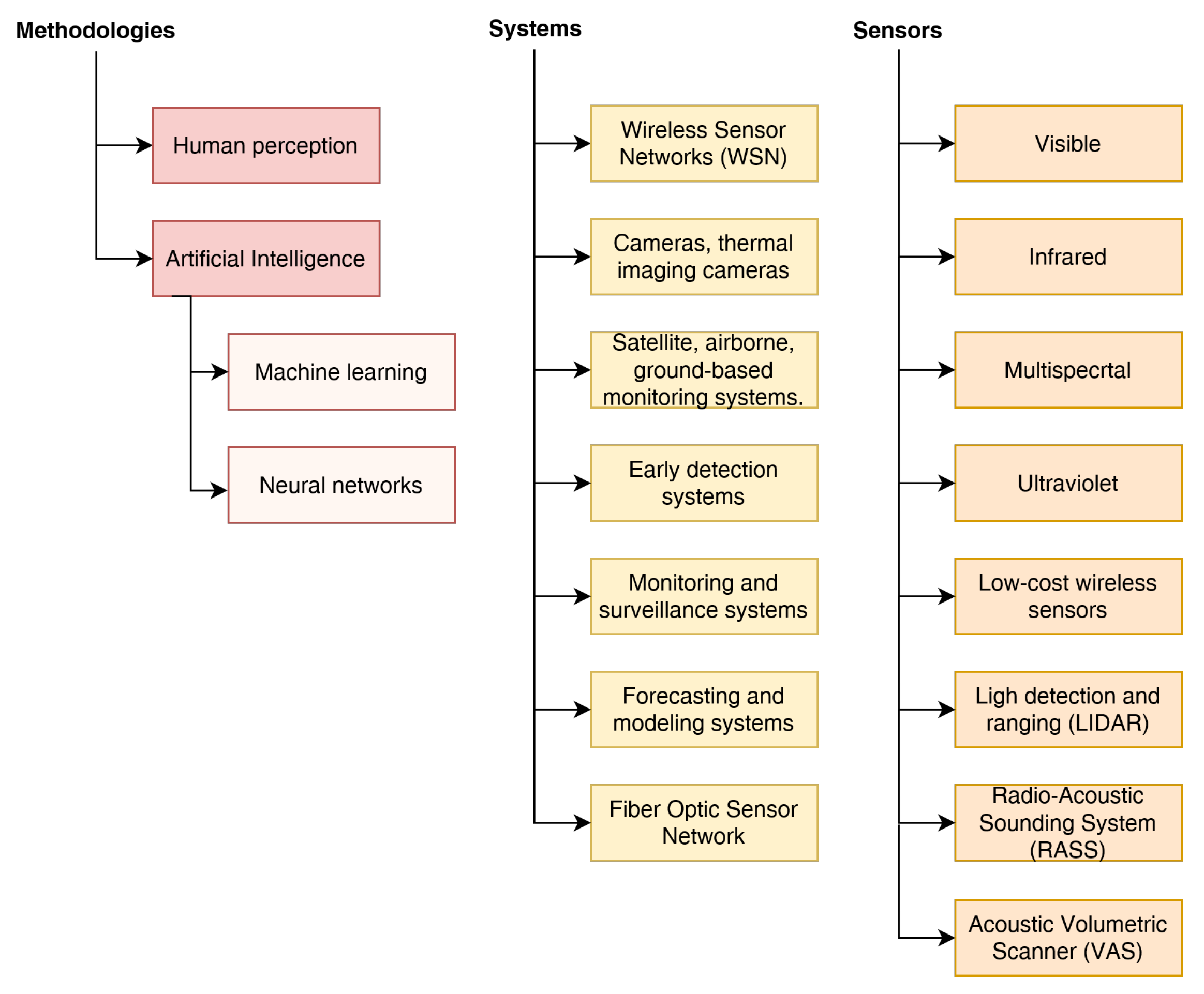
:1. Introduction
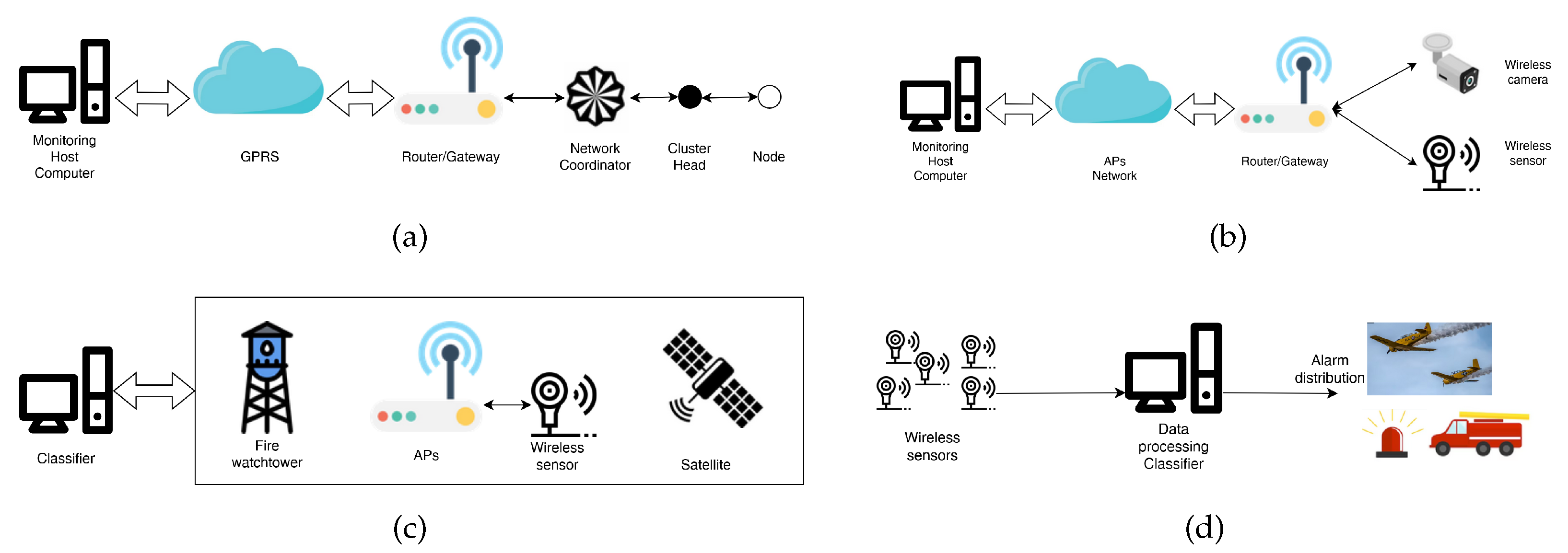
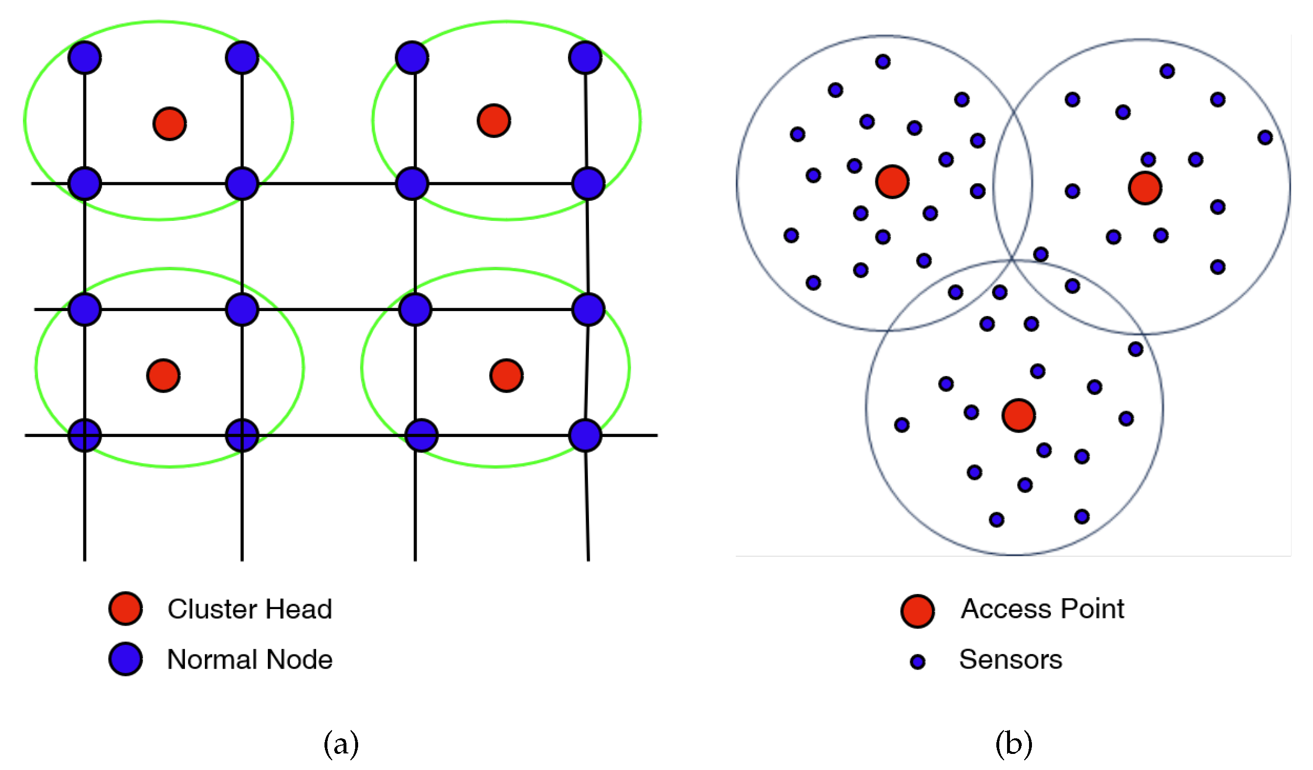
2. Wireless Sensor Networks for Fire Detection
3. Video-Based Fire Detection: Enhancing Fire Detection Systems with Visual Analysis
3.1. Video Fire Detection in the Visible Spectrum
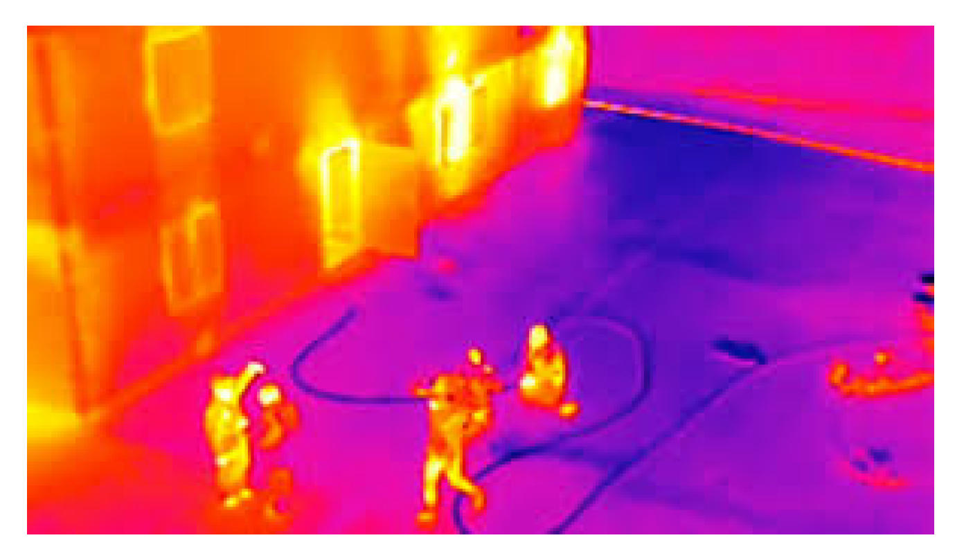
3.2. Video Fire Detection in the Infrared Spectrum
3.3. Satellite
4. The Role of Traditional Machine Learning and Deep Learning in Fire Detection and Prevention
4.1. Detection of Wildfires Using a Machine Learning Approach
4.2. Computer Vision and Convolutional Neural Networks (CNN)
5. Open Problems and Promising Research Directions
Funding
Conflicts of Interest
References
- Kimbrough, L. Forest Fires Are Getting Worse, 20 Years of Data Confirm. Monfabay. Available online: https://news.mongabay.com/2022/08/forest-fires-are-getting-worse-according-to-new-20-year-analysis/ (accessed on 17 August 2022).
- U.S. EPA. Climate Change Indicators: Wildfires; EPA: Washington, DC, USA, 2016.
- Pellegrini, A.F.A.; Anderegg, W.R.L.; Paine, C.E.T.; Hoffmann, W.A.; Kartzinel, T.; Rabin, S.S.; Sheil, D.; Franco, A.C.; Pacala, S.W. Convergence of Bark Investment According to Fire and Climate Structures Ecosystem Vulnerability to Future Change. Ecol. Lett. 2017, 20, 307–316. [Google Scholar] [CrossRef] [Green Version]
- Oris, F.; Asselin, H.; Ali, A.A.; Finsinger, W.; Bergeron, Y. Effect of increased fire activity on global warming in the boreal forest. Environ. Rev. 2014, 22, 206–219. [Google Scholar] [CrossRef] [Green Version]
- Ascoli, D.; Plana, E.; Oggioni, S.D.; Tomao, A.; Colonico, M.; Corona, P.; Giannino, F.; Moreno, M.; Xanthopoulos, G.; Kaoukis, K.; et al. Fire-smart solutions for sustainable wildfire risk prevention: Bottom-up initiatives meet top-down policies under EU green deal. Int. J. Disaster Risk Reduct. 2023, 92, 103715. [Google Scholar] [CrossRef]
- Ding, Y.; Wang, M.; Fu, Y.; Zhang, L.; Wang, X. A Wildfire Detection Algorithm Based on the Dynamic Brightness Temperature Threshold. Forests 2023, 14, 477. [Google Scholar] [CrossRef]
- Andrews, P.L. BEHAVE: Fire Behavior Prediction and Fuel Modeling System: BURN Subsystem, Part 1; U.S. Department of Agriculture, Forest Service, Intermountain Research Station: Reno, NV, USA, 1986.
- Stipanicev, D.; Bodrozic, L.; Stula, M. Environmental Intelligence Based on Advanced Sensor Networks. In Proceedings of the 2007 14th International Workshop on Systems, Signals and Image Processing and 6th EURASIP Conference focused on Speech and Image Processing, Multimedia Communications and Services, Maribor, Slovenia, 27–30 June 2007; pp. 209–212. [Google Scholar] [CrossRef]
- Bennet, B.M.; Hoffman, D.; Prakashi, C. Observer Mechanics—A Formal Theory of Perception; Academic Press: Cambridge, MA, USA, 1989. [Google Scholar]
- Sousa, D.; Cruz-Jesus, F.; Sousa, A.; Painho, M. A multivariate approach to assess the structural determinants of large wildfires: Evidence from a Mediterranean country. Int. J. Wildland Fire 2021, 30, 241–254. [Google Scholar] [CrossRef]
- Granville, K.; Woolford, D.G.; Dean, C.; McFayden, C.B. Wildland fire prevention: The impact of the Modifying Industrial Operations Protocol on the growth of industrial forestry-caused wildland fires in Ontario, Canada. Int. J. Wildland Fire 2022, 31, 825–834. [Google Scholar] [CrossRef]
- Athanasiou, M.; Bouchounas, T.; Korakaki, E.; Tziritis, E.; Xanthopoulos, G.; Sitara, S. Introducing the use of fire for wildfire prevention in Greece: Pilot application of prescribed burning in Chios island. In Proceedings of the IX International Conference on Forest Fire Research, Coimbra, Portugal, 11–18 November 2022. [Google Scholar]
- McGee, T.K.; Cabling, L.P.B. Preventing wildfires with fire permits in rural Edson, Alberta. Int. J. Wildland Fire 2022, 31, 599–606. [Google Scholar] [CrossRef]
- Price, O. Bushfires. In Encyclopedia of Wildfires and Wildland-Urban Interface (WUI) Fires; Manzello, S.L., Ed.; Springer International Publishing: Cham, Switzerland, 2019; pp. 1–5. [Google Scholar] [CrossRef]
- Hollingsworth, L.T. Backing Fire. In Encyclopedia of Wildfires and Wildland-Urban Interface (WUI) Fires; Manzello, S.L., Ed.; Springer International Publishing: Cham, Switzerland, 2019; pp. 1–6. [Google Scholar] [CrossRef]
- Hegg, B. Burn Out and Backfire/Backfiring. In Encyclopedia of Wildfires and Wildland-Urban Interface (WUI) Fires; Manzello, S.L., Ed.; Springer International Publishing: Cham, Switzerland, 2019; pp. 1–3. [Google Scholar] [CrossRef]
- Priya, R.S.; Vani, K. Deep Learning Based Forest Fire Classification and Detection in Satellite Images. In Proceedings of the 2019 11th International Conference on Advanced Computing (ICoAC), Chennai, India, 18–20 December 2019; pp. 61–65. [Google Scholar] [CrossRef]
- Jiao, Z.; Zhang, Y.; Mu, L.; Xin, J.; Jiao, S.; Liu, H.; Liu, D. A YOLOv3-based Learning Strategy for Real-time UAV-based Forest Fire Detection. In Proceedings of the 2020 Chinese Control And Decision Conference (CCDC), Hefei, China, 22–24 August 2020; pp. 4963–4967. [Google Scholar] [CrossRef]
- Shen, D.; Chen, X.; Nguyen, M.; Yan, W.Q. Flame detection using deep learning. In Proceedings of the 2018 4th International Conference on Control, Automation and Robotics (ICCAR), Auckland, New Zealand, 20–23 April 2018; pp. 416–420. [Google Scholar] [CrossRef]
- Barmpoutis, P.; Papaioannou, P.; Dimitropoulos, K.; Grammalidis, N. A Review on Early Forest Fire Detection Systems Using Optical Remote Sensing. Sensors 2020, 20, 6442. [Google Scholar] [CrossRef]
- Yu, L.; Wang, N.; Meng, X. Real-time forest fire detection with wireless sensor networks. In Proceedings of the 2005 International Conference on Wireless Communications, Networking and Mobile Computing, Wuhan, China, 26 September 2005; Volume 2, pp. 1214–1217. [Google Scholar] [CrossRef]
- Zhang, J.; Li, W.; Yin, Z.; Liu, S.; Guo, X. Forest fire detection system based on wireless sensor network. In Proceedings of the 2009 4th IEEE Conference on Industrial Electronics and Applications, Xi’an, China, 25–27 May 2009; pp. 520–523. [Google Scholar]
- Aslan, Y.E.; Korpeoglu, I.; Ulusoy, Ö. A framework for use of wireless sensor networks in forest fire detection and monitoring. Comput. Environ. Urban Syst. 2012, 36, 614–625. [Google Scholar] [CrossRef]
- Lloret, J.; Garcia, M.; Bri, D.; Sendra, S. A wireless sensor network deployment for rural and forest fire detection and verification. Sensors 2009, 9, 8722–8747. [Google Scholar] [CrossRef] [Green Version]
- Bayo, A.; Antolín, D.; Medrano, N.; Calvo, B.; Celma, S. Early detection and monitoring of forest fire with a wireless sensor network system. Procedia Eng. 2010, 5, 248–251. [Google Scholar] [CrossRef] [Green Version]
- Bolourchi, P.; Uysal, S. Forest fire detection in wireless sensor network using fuzzy logic. In Proceedings of the 2013 Fifth International Conference on Computational Intelligence, Communication Systems and Networks, Madrid, Spain, 5–7 June 2013; pp. 83–87. [Google Scholar]
- Krüll, W.; Tobera, R.; Willms, I.; Essen, H.; Von Wahl, N. Early forest fire detection and verification using optical smoke, gas and microwave sensors. Procedia Eng. 2012, 45, 584–594. [Google Scholar] [CrossRef]
- Cui, F. Deployment and integration of smart sensors with IoT devices detecting fire disasters in huge forest environment. Comput. Commun. 2020, 150, 818–827. [Google Scholar] [CrossRef]
- Sahin, Y.G. Animals as mobile biological sensors for forest fire detection. Sensors 2007, 7, 3084–3099. [Google Scholar] [CrossRef] [PubMed] [Green Version]
- Sahin, Y.G.; Ince, T. Early forest fire detection using radio-acoustic sounding system. Sensors 2009, 9, 1485–1498. [Google Scholar] [CrossRef] [Green Version]
- Brüel, C.; Kjaer; Blaabjerg, C.; Com, K.; Haddad, B.; Kjaer, K.; Com, W.; Song.; Dimino, I.; Quaranta, V.; et al. Detecting and Localizing Forest Fires from Emitted Noise. In Proceedings of the VI International Conference on Forest Fire Research, Coimbra, Portugal, 15–18 November 2010. [Google Scholar]
- Fernández-Álvarez, M.; Armesto, J.; Picos, J. LiDAR-based wildfire prevention in WUI: The automatic detection, measurement and evaluation of forest fuels. Forests 2019, 10, 148. [Google Scholar] [CrossRef] [Green Version]
- Fernandez-Vallejo, M.; Lopez-Amo, M. Optical Fiber Networks for Remote Fiber Optic Sensors. Sensors 2012, 12, 3929–3951. [Google Scholar] [CrossRef] [Green Version]
- Healey, G.; Slater, D.; Lin, T.; Drda, B.; Goedeke, A.D. A system for real-time fire detection. In Proceedings of the IEEE Conference on Computer Vision and Pattern Recognition, New York, NY, USA, 15–17 June 1993; pp. 605–606. [Google Scholar]
- Borges, P.V.K.; Mayer, J.; Izquierdo, E. Efficient visual fire detection applied for video retrieval. In Proceedings of the 2008 16th European Signal Processing Conference, Lausanne, Switzeerland, 19–25 August 2008; pp. 1–5. [Google Scholar]
- Chen, T.H.; Kao, C.L.; Chang, S.M. An intelligent real-time fire-detection method based on video processing. In Proceedings of the IEEE 37th Annual 2003 International Carnahan Conference onSecurity Technology, Taipei, Taiwan, 14–16 October 2003; pp. 104–111. [Google Scholar]
- Chen, T.H.; Wu, P.H.; Chiou, Y.C. An early fire-detection method based on image processing. In Proceedings of the 2004 International Conference on Image Processing, ICIP’04, Singapore, 24–27 October 2004; Volume 3, pp. 1707–1710. [Google Scholar]
- Borges, P.V.K.; Izquierdo, E. A probabilistic approach for vision-based fire detection in videos. IEEE Trans. Circuits Syst. Video Technol. 2010, 20, 721–731. [Google Scholar] [CrossRef]
- Marbach, G.; Loepfe, M.; Brupbacher, T. An image processing technique for fire detection in video images. Fire Saf. J. 2006, 41, 285–289. [Google Scholar] [CrossRef]
- Toreyin, B.U.; Dedeoglu, Y.; Cetin, A.E. Contour based smoke detection in video using wavelets. In Proceedings of the 2006 14th European Signal Processing Conference, Florence, Italy, 4–8 September 2006; pp. 1–5. [Google Scholar]
- Rossi, L.; Akhloufi, M.; Tison, Y. On the use of stereovision to develop a novel instrumentation system to extract geometric fire fronts characteristics. Fire Saf. J. 2011, 46, 9–20. [Google Scholar] [CrossRef]
- Rudz, S.; Chetehouna, K.; Hafiane, A.; Laurent, H.; Séro-Guillaume, O. Investigation of a novel image segmentation method dedicated to forest fire applications. Meas. Sci. Technol. 2013, 24, 075403. [Google Scholar] [CrossRef]
- Celik, T.; Demirel, H. Fire detection in video sequences using a generic color model. Fire Saf. J. 2009, 44, 147–158. [Google Scholar] [CrossRef]
- Celik, T. Fast and efficient method for fire detection using image processing. ETRI J. 2010, 32, 881–890. [Google Scholar] [CrossRef] [Green Version]
- Yuan, C.; Liu, Z.; Zhang, Y. UAV-based forest fire detection and tracking using image processing techniques. In Proceedings of the 2015 International Conference on Unmanned Aircraft Systems (ICUAS), Denver, CO, USA, 9–12 June 2015; pp. 639–643. [Google Scholar]
- Chen, R.; Luo, Y.; Alsharif, M.R. Forest Fire Detection Algorithm Based on Digital Image. J. Softw. 2013, 8, 1897–1905. [Google Scholar] [CrossRef]
- Liu, C.B.; Ahuja, N. Vision based fire detection. In Proceedings of the 17th International Conference on Pattern Recognition, ICPR 2004, Cambridge, UK, 23–26 August 2004; Volume 4, pp. 134–137. [Google Scholar]
- Zhang, D.; Han, S.; Zhao, J.; Zhang, Z.; Qu, C.; Ke, Y.; Chen, X. Image based forest fire detection using dynamic characteristics with artificial neural networks. In Proceedings of the 2009 International Joint Conference on Artificial Intelligence (JCAI), Hainan, China, 25–26 April 2009; pp. 290–293. [Google Scholar]
- Dzigal, D.; Akagic, A.; Buza, E.; Brdjanin, A.; Dardagan, N. Forest fire detection based on color spaces combination. In Proceedings of the 2019 11th International Conference on Electrical and Electronics Engineering (ELECO), Bursa, Turkey, 28–30 November 2019; pp. 595–599. [Google Scholar]
- Van Hamme, D.; Veelaert, P.; Philips, W.; Teelen, K. Fire detection in color images using Markov random fields. In Proceedings of the Advanced Concepts for Intelligent Vision Systems: 12th International Conference, ACIVS 2010, Sydney, Australia, 13–16 December 2010; Proceedings, Part II. Springer: Berlin/Heidelberg, Germany, 2010; pp. 88–97. [Google Scholar]
- Qi, X.; Ebert, J. A computer vision based method for fire detection in color videos. Int. J. Imaging 2009, 2, 22–34. [Google Scholar]
- Chmelar, P.; Benkrid, A. Efficiency of HSV over RGB Gaussian Mixture Model for fire detection. In Proceedings of the 2014 24th International Conference Radioelektronika, Bratislava, Slovakia, 15–16 April 2014; pp. 1–4. [Google Scholar]
- Pritam, D.; Dewan, J.H. Detection of fire using image processing techniques with LUV color space. In Proceedings of the 2017 2nd International Conference for Convergence in Technology (I2CT), Mumbai, India, 7–9 April 2017; pp. 1158–1162. [Google Scholar]
- Horng, W.B.; Peng, J.W.; Chen, C.Y. A new image-based real-time flame detection method using color analysis. In Proceedings of the Proceedings 2005 IEEE Networking, Sensing and Control, Tucson, AZ, USA, 19-22 March 2005; pp. 100–105. [Google Scholar]
- Khatami, A.; Mirghasemi, S.; Khosravi, A.; Nahavandi, S. A new color space based on k-medoids clustering for fire detection. In Proceedings of the 2015 IEEE International Conference on Systems, Man, and Cybernetics, Kowloon Tong, Hong Kong, 9–12 October 2015; pp. 2755–2760. [Google Scholar]
- Dedeoglu, N.; Toreyin, B.U.; Gudukbay, U.; Cetin, A.E. Real-time fire and flame detection in video. In Proceedings of the Proceedings.(ICASSP’05). IEEE International Conference on Acoustics, Speech, and Signal Processing, Philadelphia, PA, USA, 18–23 March 2005; Volume 2, pp. ii/669–ii/672. [Google Scholar]
- Töreyin, B.U.; Dedeoğlu, Y.; Güdükbay, U.; Cetin, A.E. Computer vision based method for real-time fire and flame detection. Pattern Recognit. Lett. 2006, 27, 49–58. [Google Scholar] [CrossRef] [Green Version]
- Töreyin, B.U.; Cinbiş, R.G.; Dedeoğlu, Y.; Çetin, A.E. Fire detection in infrared video using wavelet analysis. Opt. Eng. 2007, 46, 067204. [Google Scholar] [CrossRef] [Green Version]
- Toreyin, B.U.; Cetin, A.E. Online detection of fire in video. In Proceedings of the 2007 IEEE Conference on Computer Vision and Pattern Recognition, Minneapolis, MI, USA, 17–22 June 2007; pp. 1–5. [Google Scholar]
- Xu, Z.; Xu, J. Automatic fire smoke detection based on image visual features. In Proceedings of the 2007 International Conference on Computational Intelligence and Security Workshops (CISW 2007), Harbin, China, 15–19 December 2007; pp. 316–319. [Google Scholar]
- Toreyin, B.; Dedeoglu, Y.; Cetin, A. Flame detection in video using hidden Markov models. In Proceedings of the IEEE International Conference on Image Processing 2005, Genova, Italy, 14 September 2005; Volume 2, pp. II–1230. [Google Scholar] [CrossRef]
- Teng, Z.; Kim, J.H.; Kang, D.J. Fire detection based on hidden Markov models. Int. J. Control. Autom. Syst. 2010, 8, 822–830. [Google Scholar] [CrossRef]
- Günay, O.; Taşdemir, K.; Uğur Töreyin, B.; Çetin, A.E. Fire detection in video using LMS based active learning. Fire Technol. 2010, 46, 551–577. [Google Scholar] [CrossRef]
- Ko, B.C.; Cheong, K.H.; Nam, J.Y. Fire detection based on vision sensor and support vector machines. Fire Saf. J. 2009, 44, 322–329. [Google Scholar] [CrossRef]
- Habiboğlu, Y.H.; Günay, O.; Cetin, A.E. Flame detection method in video using covariance descriptors. In Proceedings of the 2011 IEEE International Conference on Acoustics, Speech and Signal Processing (ICASSP), Prague, Czech Republic, 22–27 May 2011; pp. 1817–1820. [Google Scholar]
- Dimitropoulos, K.; Barmpoutis, P.; Grammalidis, N. Spatio-temporal flame modeling and dynamic texture analysis for automatic video-based fire detection. IEEE Trans. Circuits Syst. Video Technol. 2014, 25, 339–351. [Google Scholar] [CrossRef]
- Wu, X.; Lu, X.; Leung, H. A video based fire smoke detection using robust AdaBoost. Sensors 2018, 18, 3780. [Google Scholar] [CrossRef] [Green Version]
- Verstockt, S.; Vanoosthuyse, A.; Van Hoecke, S.; Lambert, P.; Van de Walle, R. Multi-sensor fire detection by fusing visual and non-visual flame features. In Proceedings of the Image and Signal Processing: 4th International Conference, ICISP 2010, Trois-Rivières, QC, Canada, 30 June–2 July 2010; Proceedings 4. Springer: Berlin/Heidelberg, Germany, 2010; pp. 333–341. [Google Scholar]
- Foo, S.Y. A rule-based machine vision system for fire detection in aircraft dry bays and engine compartments. Knowl.-Based Syst. 1996, 9, 531–540. [Google Scholar] [CrossRef]
- Phillips Iii, W.; Shah, M.; da Vitoria Lobo, N. Flame recognition in video. Pattern Recognit. Lett. 2002, 23, 319–327. [Google Scholar] [CrossRef]
- Yuan, C.; Liu, Z.; Zhang, Y. Fire detection using infrared images for UAV-based forest fire surveillance. In Proceedings of the 2017 International Conference on Unmanned Aircraft Systems (ICUAS), Miami, FL, USA, 13–16 June 2017; pp. 567–572. [Google Scholar]
- Ko, B.; Cheong, K.H.; Nam, J.Y. Early fire detection algorithm based on irregular patterns of flames and hierarchical Bayesian Networks. Fire Saf. J. 2010, 45, 262–270. [Google Scholar] [CrossRef]
- Muhammad, K.; Ahmad, J.; Lv, Z.; Bellavista, P.; Yang, P.; Baik, S.W. Efficient deep CNN-based fire detection and localization in video surveillance applications. IEEE Trans. Syst. Man, Cybern. Syst. 2018, 49, 1419–1434. [Google Scholar] [CrossRef]
- Muhammad, K.; Khan, S.; Elhoseny, M.; Ahmed, S.H.; Baik, S.W. Efficient fire detection for uncertain surveillance environment. IEEE Trans. Ind. Inform. 2019, 15, 3113–3122. [Google Scholar] [CrossRef]
- Kim, B.; Lee, J. A video-based fire detection using deep learning models. Appl. Sci. 2019, 9, 2862. [Google Scholar] [CrossRef] [Green Version]
- Kolesov, I.; Karasev, P.; Tannenbaum, A.; Haber, E. Fire and smoke detection in video with optimal mass transport based optical flow and neural networks. In Proceedings of the 2010 IEEE International Conference on Image Processing, Hong Kong, China, 26–29 September 2010; pp. 761–764. [Google Scholar]
- Yuan, F. A fast accumulative motion orientation model based on integral image for video smoke detection. Pattern Recognit. Lett. 2008, 29, 925–932. [Google Scholar] [CrossRef]
- Chen, T.H.; Yin, Y.H.; Huang, S.F.; Ye, Y.T. The smoke detection for early fire-alarming system base on video processing. In Proceedings of the 2006 International Conference on Intelligent Information Hiding and Multimedia, Pasadena, CA, USA, 18–20 December 2006; pp. 427–430. [Google Scholar]
- Calderara, S.; Piccinini, P.; Cucchiara, R. Smoke detection in video surveillance: A MoG model in the wavelet domain. In Proceedings of the Computer Vision Systems: 6th International Conference, ICVS 2008, Santorini, Greece, 12–15 May 2008; Proceedings 6. Springer: Berlin/Heidelberg, Germany, 2008; pp. 119–128. [Google Scholar]
- Ajith, M.; Martínez-Ramón, M. Unsupervised segmentation of fire and smoke from infra-red videos. IEEE Access 2019, 7, 182381–182394. [Google Scholar] [CrossRef]
- Li, Z.; Khananian, A.; Fraser, R.; Cihlar, J. Automatic detection of fire smoke using artificial neural networks and threshold approaches applied to AVHRR imagery. IEEE Trans. Geosci. Remote Sens. 2001, 39, 1859–1870. [Google Scholar] [CrossRef] [Green Version]
- Schroeder, W.; Oliva, P.; Giglio, L.; Quayle, B.; Lorenz, E.; Morelli, F. Active fire detection using Landsat-8/OLI data. Remote. Sens. Environ. 2016, 185, 210–220. [Google Scholar] [CrossRef] [Green Version]
- Csiszar, I.; Morisette, J.; Giglio, L. Validation of active fire detection from moderate-resolution satellite sensors: The MODIS example in northern eurasia. IEEE Trans. Geosci. Remote. Sens. 2006, 44, 1757–1764. [Google Scholar] [CrossRef]
- Ghorbanzadeh, O.; Blaschke, T.; Gholamnia, K.; Aryal, J. Forest Fire Susceptibility and Risk Mapping Using Social/Infrastructural Vulnerability and Environmental Variables. Fire 2019, 2, 50. [Google Scholar] [CrossRef] [Green Version]
- Ma, W.; Feng, Z.; Cheng, Z.; Chen, S.; Wang, F. Identifying Forest Fire Driving Factors and Related Impacts in China Using Random Forest Algorithm. Forests 2020, 11, 507. [Google Scholar] [CrossRef]
- Wu, Z.; Wang, B.; Li, M.; Tian, Y.; Quan, Y.; Liu, J. Simulation of forest fire spread based on artificial intelligence. Ecol. Indic. 2022, 136, 108653. [Google Scholar] [CrossRef]
- Sun, T.; Zhang, L.; Chen, W.; Tang, X.; Qin, Q. Mountains forest fire spread simulator based on geo-cellular automaton combined with wang zhengfei velocity model. IEEE J. Sel. Top. Appl. Earth Obs. Remote Sens. 2012, 6, 1971–1987. [Google Scholar] [CrossRef]
- Sun, Y.; Zhang, F.; Lin, H.; Xu, S. A Forest Fire Susceptibility Modeling Approach Based on Light Gradient Boosting Machine Algorithm. Remote Sens. 2022, 14, 4362. [Google Scholar] [CrossRef]
- Zhou, K.; Zhang, F. An Event-Response Tree-Based Resource Scheduling Method for Wildfire Fighting. Forests 2023, 14, 102. [Google Scholar] [CrossRef]
- Yang, X.; Wang, Y.; Liu, X.; Liu, Y. High-Precision Real-Time forest fire video detection using One-Class model. Forests 2022, 13, 1826. [Google Scholar] [CrossRef]
- Abdollahi, A.; Pradhan, B. Explainable artificial intelligence (XAI) for interpreting the contributing factors feed into the wildfire susceptibility prediction model. Sci. Total Environ. 2023, 879, 163004. [Google Scholar] [CrossRef] [PubMed]
- Cilli, R.; Elia, M.; D’Este, M.; Giannico, V.; Amoroso, N.; Lombardi, A.; Pantaleo, E.; Monaco, A.; Sanesi, G.; Tangaro, S.; et al. Explainable artificial intelligence (XAI) detects wildfire occurrence in the Mediterranean countries of Southern Europe. Sci. Rep. 2022, 12, 16349. [Google Scholar] [CrossRef] [PubMed]
- Bountzouklis, C.; Fox, D.M.; Di Bernardino, E. Predicting wildfire ignition causes in Southern France using eXplainable Artificial Intelligence (XAI) methods. Environ. Res. Lett. 2023, 18, 044038. [Google Scholar] [CrossRef]
- Cappellini, V.; Mattii, L.; Mecocci, A. An intelligent system for automatic fire detection in forests. In Recent Issues in Pattern Analysis and Recognition; Springer: Berlin/Heidelberg, Germany, 2005; pp. 351–364. [Google Scholar] [CrossRef]
- Okayama, Y. A primitive study of a fire detection method controlled by artificial neural net. Fire Saf. J. 1991, 17, 535–553. [Google Scholar] [CrossRef]
- Arrue, B.C.; Ollero, A.; De Dios, J.M. An intelligent system for false alarm reduction in infrared forest-fire detection. IEEE Intell. Syst. Their Appl. 2000, 15, 64–73. [Google Scholar] [CrossRef] [Green Version]
- Chen, Y.; Serio, M.A.; Sathyamoorthy, S. Development of a fire detection system using FT-IR spectroscopy and artificial neural networks. In Proceedings of the Sixth International Symposium of the International Association for Fire Safety Science, Poitiers, France, 5–9 July 1999; pp. 791–802. [Google Scholar]
- Mahdi, A.S.; Mahmood, S.A. Analysis of Deep Learning Methods for Early Wildfire Detection Systems. In Proceedings of the 2022 5th International Conference on Engineering Technology and its Applications (IICETA), Al-Najaf, Iraq, 31 May–1 June 2022; pp. 271–276. [Google Scholar]
- Seydi, S.T.; Saeidi, V.; Kalantar, B.; Ueda, N.; Halin, A.A. Fire-Net: A deep learning framework for active forest fire detection. J. Sens. 2022, 2022, 1–14. [Google Scholar] [CrossRef]
- Abdusalomov, A.B.; Islam, B.M.S.; Nasimov, R.; Mukhiddinov, M.; Whangbo, T.K. An improved forest fire detection method based on the detectron2 model and a deep learning approach. Sensors 2023, 23, 1512. [Google Scholar] [CrossRef]
- Xue, Z.; Lin, H.; Wang, F. A small target forest fire detection model based on YOLOv5 improvement. Forests 2022, 13, 1332. [Google Scholar] [CrossRef]
- Thangavel, K.; Spiller, D.; Sabatini, R.; Amici, S.; Sasidharan, S.T.; Fayek, H.; Marzocca, P. Autonomous Satellite Wildfire Detection Using Hyperspectral Imagery and Neural Networks: A Case Study on Australian Wildfire. Remote Sens. 2023, 15, 720. [Google Scholar] [CrossRef]
- James, G.L.; Ansaf, R.B.; Al Samahi, S.S.; Parker, R.D.; Cutler, J.M.; Gachette, R.V.; Ansaf, B.I. An Efficient Wildfire Detection System for AI-Embedded Applications Using Satellite Imagery. Fire 2023, 6, 169. [Google Scholar] [CrossRef]
- Peruzzi, G.; Pozzebon, A.; Van Der Meer, M. Fight Fire with Fire: Detecting Forest Fires with Embedded Machine Learning Models Dealing with Audio and Images on Low Power IoT Devices. Sensors 2023, 23, 783. [Google Scholar] [CrossRef]
- Johnston, J.; Zeng, K.; Wu, N. An Evaluation and Embedded Hardware Implementation of YOLO for Real-Time Wildfire Detection. In Proceedings of the 2022 IEEE World AI IoT Congress (AIIoT), Seattle, WA, USA, 6–9 June 2022; pp. 138–144. [Google Scholar] [CrossRef]
- Arguello, J.D.P.; Hernández, C.J.B.; Ferreira, J.R. Towards Fire Identification Model in Satellite Images Using HPC Embedded Systems and AI. In Proceedings of the Latin American High Performance Computing Conference, Porto Alegre, Brazil, 26–30 September 2022; Springer: Berlin/Heidelberg, Germany, 2022; pp. 103–115. [Google Scholar]
- Nassar, A.; AlAjlouni, M.M.; AlNabelsi, A.; Alrawashdeh, Z.; Hejazi, B.; Alwardat, R.; Lima, J. A Machine Learning-Based Early Forest Fire Detection System Utilizing Vision and Sensors’ Fusion Technologies. In Proceedings of the 2022 4th IEEE Middle East and North Africa COMMunications Conference (MENACOMM), Amman, Jordan, 6–8 December 2022; pp. 229–234. [Google Scholar]
- Frizzi, S.; Kaabi, R.; Bouchouicha, M.; Ginoux, J.M.; Moreau, E.; Fnaiech, F. Convolutional neural network for video fire and smoke detection. In Proceedings of the IECON 2016-42nd Annual Conference of the IEEE Industrial Electronics Society, Florence, Italy, 24–27 October 2016; pp. 877–882. [Google Scholar]
- Cao, Y.; Yang, F.; Tang, Q.; Lu, X. An attention enhanced bidirectional LSTM for early forest fire smoke recognition. IEEE Access 2019, 7, 154732–154742. [Google Scholar] [CrossRef]
- Xu, R.; Lin, H.; Lu, K.; Cao, L.; Liu, Y. A forest fire detection system based on ensemble learning. Forests 2021, 12, 217. [Google Scholar] [CrossRef]
- Chen, G.; Zhou, H.; Li, Z.; Gao, Y.; Bai, D.; Xu, R.; Lin, H. Multi-Scale Forest Fire Recognition Model Based on Improved YOLOv5s. Forests 2023, 14, 315. [Google Scholar] [CrossRef]
- Qian, J.; Lin, H. A forest fire identification system based on weighted fusion algorithm. Forests 2022, 13, 1301. [Google Scholar] [CrossRef]
- Zhang, L.; Wang, M.; Ding, Y. Forest Fire Recognition Based on GNN With Dynamic Feature Similarity of Multi-View Images. Preprints 2021. [Google Scholar] [CrossRef]
- Ghali, R.; Akhloufi, M.A.; Jmal, M.; Souidene Mseddi, W.; Attia, R. Wildfire Segmentation Using Deep Vision Transformers. Remote Sens. 2021, 13, 3527. [Google Scholar] [CrossRef]
- Qin, K.; Hou, X.; Yan, Z.; Zhou, F.; Bu, L. FGL-GAN: Global-Local Mask Generative Adversarial Network for Flame Image Composition. Sensors 2022, 22, 6332. [Google Scholar] [CrossRef]
- Park, M.; Bak, J.; Park, S. Advanced wildfire detection using generative adversarial network-based augmented datasets and weakly supervised object localization. Int. J. Appl. Earth Obs. Geoinf. 2022, 114, 103052. [Google Scholar] [CrossRef]
- Aslan, S.; Güdükbay, U.; Töreyin, B.U.; Cetin, A.E. Early wildfire smoke detection based on motion-based geometric image transformation and deep convolutional generative adversarial networks. In Proceedings of the ICASSP 2019—2019 IEEE International Conference on Acoustics, Speech and Signal Processing (ICASSP), Brighton, UK, 12–17 May 2019; pp. 8315–8319. [Google Scholar]
- Jiang, W.; Wang, F.; Su, G.; Li, X.; Wang, G.; Zheng, X.; Wang, T.; Meng, Q. Modeling wildfire spread with an irregular graph network. Fire 2022, 5, 185. [Google Scholar] [CrossRef]
- Li, A.; Zhao, Y.; Zheng, Z. Novel Recursive BiFPN Combining with Swin Transformer for Wildland Fire Smoke Detection. Forests 2022, 13, 2032. [Google Scholar] [CrossRef]


| Paper | Color Space | Real-Time | Spectral Analysis | Moving Object | Classifier/ HMM | Wavelet | NN | Statistical Analysis | Smoke |
|---|---|---|---|---|---|---|---|---|---|
| [34] | RGB | X | X | ||||||
| [37] | RGB/HSI | X | X | X | |||||
| [38] | RGB | X | X | ||||||
| [39] | YUV | X | |||||||
| [40] | YUV | X | X | ||||||
| [41] | YUV | X | X | X | |||||
| [42] | YCbCr | X | X | X | |||||
| [43] | YCbCr/RGB | X | |||||||
| [44] | Lab | X | X | X | X | ||||
| [45] | Lab | X | |||||||
| [46] | Lab/YCbCr | X | X | X | |||||
| [47] | HSV | X | X | ||||||
| [48] | HSV | X | X | X | |||||
| [49] | HSV/HSL | X | |||||||
| [50] | HSV | X | X | HMM | |||||
| [51] | RGB/HSV | X | X | X | |||||
| [52] | RGB/HSV | X | X | ||||||
| [53] | Luv | X | X | X | X | ||||
| [54] | HSI | X | X | X | |||||
| [55] | FCS | X | X | ||||||
| [56] | X | X | |||||||
| [57] | RGB | X | X | X | |||||
| [59] | X | X | weak classifier, HMM | X | |||||
| [60] | greyscale | X | X | X | X | X | |||
| [62] | X | X | HMM | X | |||||
| [64] | X | SVM | X | ||||||
| [65] | X | SVM | X | ||||||
| [66] | RGB | SVM | X | ||||||
| [67] | X | RAB | X | X | |||||
| [69] | X | ||||||||
| [70] | RGB | X | X | X | |||||
| [72] | RGB | X | X | X | X | ||||
| [73,74] | X | X | X | X | |||||
| [75] | X | ||||||||
| [77] | RGB | X | X | X | X | X | |||
| [78] | X | X | X |
| Image Sensor | AVHRR | MODIS | VIIRS |
|---|---|---|---|
| Spatial Resolution | 1 km | 1 km | 750 m |
| Spectral Band | 6 (bands at 1 km) | 36 (2 bands at 250 m, 5 bands at 500 m and 29 at 1 km resolution) | 22 (16 moderate-resolution bands at 750 m, 5 image resolution at 750 m and 1 pancromatic day/night at 750 m) |
| Advantages | infrared | more various channels for more perfect earth mapping | The pancromatic day/night band gives an opportunity to take more accurate forest fire data |
| Disadvantages | Few channels for multiple image analyze in terms of resolution. To complete earth mapping it takes 102 min | To complete earth mapping it takes 99 min | To complete earth mapping it takes 50 min |
| Technique | Real-Time Detection | Reliability in Identification | Wildfire Prediction | Simulation of Fire Spread | Robustness | Complexity | Area Covered |
|---|---|---|---|---|---|---|---|
| ML models w/ environment data | X | Low | X | X | Low | Low/Medium | Medium/Large |
| Computer vision | X | High | High | High | Very variable |
Disclaimer/Publisher’s Note: The statements, opinions and data contained in all publications are solely those of the individual author(s) and contributor(s) and not of MDPI and/or the editor(s). MDPI and/or the editor(s) disclaim responsibility for any injury to people or property resulting from any ideas, methods, instructions or products referred to in the content. |
© 2023 by the authors. Licensee MDPI, Basel, Switzerland. This article is an open access article distributed under the terms and conditions of the Creative Commons Attribution (CC BY) license (https://creativecommons.org/licenses/by/4.0/).
Share and Cite
Carta, F.; Zidda, C.; Putzu, M.; Loru, D.; Anedda, M.; Giusto, D. Advancements in Forest Fire Prevention: A Comprehensive Survey. Sensors 2023, 23, 6635. https://doi.org/10.3390/s23146635
Carta F, Zidda C, Putzu M, Loru D, Anedda M, Giusto D. Advancements in Forest Fire Prevention: A Comprehensive Survey. Sensors. 2023; 23(14):6635. https://doi.org/10.3390/s23146635
Chicago/Turabian StyleCarta, Francesco, Chiara Zidda, Martina Putzu, Daniele Loru, Matteo Anedda, and Daniele Giusto. 2023. "Advancements in Forest Fire Prevention: A Comprehensive Survey" Sensors 23, no. 14: 6635. https://doi.org/10.3390/s23146635