Article

Dynamics of Diversity of Woody Species Taxa under Human Impact in the Upper Volga Region (NW Russia) According to Pedoanthracological Data

by
Maxim V. Bobrovsky
1,*,
Dmitry A. Kupriyanov
2,
Alexei L. Smirnov
2,
Larisa G. Khanina
3,
Maria V. Dobrovolskaya
2 and
Alexei V. Tiunov
4
1
Institute of Physicochemical and Biological Problems in Soil Science of RAS, Pushchino Scientific Center for Biological Research, Russian Academy of Sciences, Pushchino 142290, Russia
2
Institute of Archeology, Russian Academy of Sciences, Moscow 117992, Russia
3
Institute of Mathematical Problems of Biology of RAS, Branch of the M.V. Keldysh Institute of Applied Mathematics, Russian Academy of Sciences, Pushchino 142290, Russia
4
A.N. Severtsov Institute of Ecology and Evolution, Russian Academy of Sciences, Moscow 119071, Russia
*
Author to whom correspondence should be addressed.
Diversity 2023, 15(3), 403; https://doi.org/10.3390/d15030403
Submission received: 16 January 2023 / Revised: 24 February 2023 / Accepted: 3 March 2023 / Published: 10 March 2023

Abstract

:
We studied charcoal from several types of natural soil archives, including cultural layers of archaeological sites (hillforts), surrounding forest and arable soils, and sediments in lower parts of the slopes associated with hillforts and moraine hills. The stratigraphy of the charcoals was described, and 41 samples were radiocarbon-dated. Analysis of 2277 charcoals showed the presence of 13 taxa of woody species; Pinus and Picea charcoals dominated. Charcoals older than 300 BC were found only in sediment and in several pits formed after treefalls with uprooting. The greatest diversity of woody species was found in the hillforts’ cultural layers composed of Anthropogenic Dark Earth soils formed between 300 BC and 300 cal. AD (Early Iron Age). All charcoals from ancient arable soils were younger than charcoals from the hillforts. Charcoals indicated that burning for arable farming started in the study region in the 6th century AD. Woody taxa exhibited a decrease in number of species and a decrease in the proportion of nemoral (broadleaved) species from the Early Iron Age to the Middle Ages and to the present. Quercus, Tilia, and Corylus have become relatively rare, although they still occur in the study region. Ulmus and Acer are now rare in the Upper Volga region and were not found in the vicinity of the study sites.

1. Introduction

The composition of plant communities has been influenced by anthropogenic activities for many thousands of years. Both the development of the economy and its impact on forest landscapes have not been uniform over time and space. To identify periods critical for changes in the composition and structure of forest landscapes, historical reconstructions that are based on natural archives such as soil or peat are needed. Pedoanthracology, which studies charcoal from soils and sediments, is an indispensable tool in such reconstructions [1,2].
The methods of pedoanthracology allow us to reconstruct the history of specific sites, regimes of natural and anthropogenic disturbances in ecosystems and landscapes of different types, and reveal the dynamics of the taxonomic composition and distribution of woody species based on the analysis of soil charcoals and their dating [3,4,5,6,7,8]. An important advantage of this method is the ability to reconstruct the history of specific areas, which is especially valuable when archaeological sites are investigated [9,10,11,12,13].
The territory we studied is located in the Tver Region, Peno district, in the northwest of the Valdai Upland. It belongs to the chronicle Okovskiy Forest, which harbors the sources of the three great rivers: Volga, Dnieper, and Western Dvina (Daugava). Mentions of this area in historical records combine the conflicting characteristics of an old-growth impenetrable forest with actively developed transport routes and the constant export of ship timber from these places [14]. In general, there is a large number of archaeological sites in the Tver region. The archaeological map of the Peno district, for instance, includes more than 300 archeological sites of various periods since the Final Paleolithic [15]. There are, however, local areas that are both ecologically and historically poorly studied. One such white spot on the archaeological map is the local area between the Runa and Kud Rivers. In recent years, a network of hillforts of the Early Iron Age (500 BC to 500 AD [15]) and possibly Early Middle Ages, as well as a significant number of barrows (mounds), has been discovered here [14]. The history of the natural environment in this region was assessed via multiproxy analysis of deposits of the Krivetskiy Mokh bog [16].
In the current study, we intended to combine the study of archaeological sites and background soils to analyze the dynamics of taxonomic diversity of woody plant species to reveal the relationship of the stratigraphy, concentration, and taxonomic composition of charcoals of different times with human activity.

2. Materials and Methods
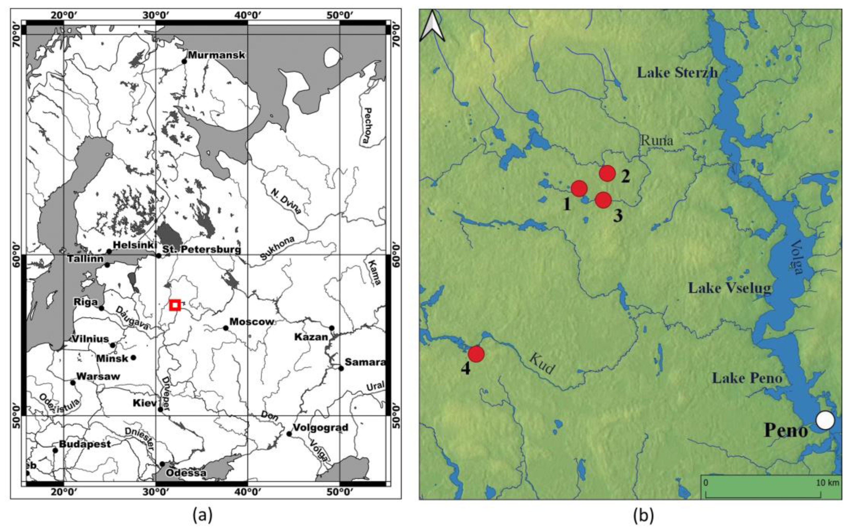
2.1. Study Area

The study area is bounded from the west and southwest by the watershed of the Western Dvina and Volkhov Rivers and from the east by the chain of Upper Volga Lakes, which are part of the Volga River (Figure 1).
The climate is temperate and moderately continental with a relatively cold winter (average temperature in January: −5.9 °C) and warm summer (average temperature in July: 18.3 °C) (data source: Toropets weather station, 80 km southwest from the study area, 1988–2019; http://www.meteo.ru). The average annual temperature is 5.6 °C, and the average annual precipitation is about 760 mm.
The area belongs to the hemiboreal forest region [17] located to the south of the taiga forest region. Landscapes include hilly plains (150–250 m a.s.l. with a maximum elevation of 275 m) moderately dissected by valleys of small streams and depressions. Moraine materials and fluvioglacial sands form Quaternary deposits. Moraine ridges and hills are 6 to 20 m high and 100 to 1500 m long; they are mostly oriented from northwest to southeast. There are a large number of lakes and mires developed in depressions between moraine hills. Sandy soils prevail in the region: Podzols dominate, Arenosols also occur; Stagnic Podzols and Histosols are common in depressions bordering the bogs [18].
At present, the region is sparsely populated. Significant areas of agricultural lands were abandoned 15–30 years ago, and now, the area of cultivated arable land and meadows is very small; forests predominate.

2.2. Site Characteristics

Four local areas (sites) (Figure 1) were investigated. Depending on the local conditions, we studied soil charcoal in all or some of the six types of land: (1) hillforts, (2) sediments below hillforts, (3) forest soils on flat areas, (4) sediments below slopes in the forests, (5) modern arable lands, and (6) modern vegetable gardens.
The Zaborovka-Likhusha site (ZL) is located to the southeast of the village Zaborovka (57.09° N, 32.43° E). The site included a moraine hill, on which Zaborovka-Likhusha hillfort is located, and the surrounding undulating plain. The hillfort is bounded to the north by the right bank of the Zaborovka River (right tributary of the Runa River, a tributary of the Sterzh Lake, Verkhnevolzhskoye water reservoir); to the west and north, it is bounded by a stream, and to the east, by a marsh [14,19]. On the moraine hill, there is also a group of barrows (second half of the 1st millennium AD). The hill is located inside a large forested area. To the west are arable lands, the village of Pustoshka, and the abandoned village of Otonets, where the soils of vegetable gardens were studied.
The Runa-Zaborovka site (RZ) is located to the north-northeast of the village Zaborovka, on the right bank of the Runa River, 0.7 km from the riverbed (57.11° N, 32.43° E). The site included a small moraine hill on which Runa-Zaborovka hillfort is located [19] and a drained flat area surrounded by marshy lowlands. The entire area of the site is covered by forest.
The Voroshilovo site (V) is located east of the village Voroshilovo on the right bank of the Kud River, about 500 m from the shoreline (56.97° N, 32.24° E). The site included a forested moraine hill, on top of which was Voroshilovo hillfort [19], a small forest area between the hill and the river, and modern cultivated and abandoned arable lands surrounding the hill from other sides.
The Krasnyi Bor site (KB) (57.10° N, 32.39° E) included several moraine hills with damp depressions between them. On the hills, there were several groups of mounds (second half of the 1st millennium AD). The site was located within a large forested area.
In all the sites, including the hillforts, Pinus sylvestris L. (Scots pine) and Picea abies (L.) H. Karst (European spruce) dominated the forest canopy. The age of Pinus sylvestris ranged from 80 to 110 years, according to the tree coring. Picea abies dominated in the undergrowth. Betula pubescens Ehrh. (downy birch), B. pendula Roth (silver birch), and Populus tremula L. (European aspen) often occurred in the overstorey, but rarely in the understorey. Alnus incana (L.) Moench (grey alder) was rarely found in the sites, but it is generally common in damp depressions and abandoned arable lands in the region. Salix spp. (willow) was common in damp places: on the banks of rivers, streams, lakes, abandoned damp meadows, and arable lands. Quercus robur L. (pedunculate oak) was rare in the canopy but occurred in the understorey. Tilia cordata Mill. (small-leaved lime) was rare but was found in all the sites, usually in depressions as vegetatively regenerating young trees. Acer platanoides L. (Norway maple) and Ulmus glabra Huds. (Scots elm) were absent at the sites studied, but they were found several tens of kilometers northwest of the study sites. In the understorey, Sorbus aucuparia L. and Frangula alnus Mill. often occurred; Corylus avellana (L.) H. Karst., Euonymus verrucosus Scop., Lonicera xylosteum L., Daphne mezereum L., and Juniperus communis L. were rarely found. Forest floor vegetation in the hillforts differed from the surrounding forests by low participation of boreal dwarf-shrubs, such as Vaccinium myrtillus L. and V. vitis-idaea L., and green mosses: nemoral herbs, such as Galeobdolon luteum Huds., Asarum europaeum L., Stellaria holostea L., Pulmonaria obscura Dumort., and Aegopodium podagraria L., etc. were common together with Hepatica nobilis Mill. and Urtica dioica L.

2.3. Charcoal Sampling and Analysis

To reconstruct the historical dynamic of woody taxa, we analyzed the concentration, taxonomical composition, and radiocarbon dates of charcoals found in soil samples taken in 2019 in six land types in four study sites. The Zaborovka-Likhusha site was the main object of our study, because all the land types were present there.
For hillforts, soil samples were taken from the cultural layer using a soil auger (5 cm in diameter) with a 15 cm increment to a depth of about 150 cm. Four cores were taken in the Zaborovka-Likhusha hillfort and three cores each in Runa-Zaborovka and Voroshilovo hillforts. All the soil cores taken in one hillfort we analyzed here as one “combined soil profile”, whereas a detailed analysis of the distribution of charcoal by depth and among the cores was performed by Bobrovsky et al. [19]. In the other land types, 38 full-scale soil profiles were excavated to a depth of 90 to 120 cm (Table 1). For full-scale profiles, we described morphological patterns associated with the history of human exploration of the territory (the ancient arable horizon, pits from treefalls with uprooting, and ancient root channels; see below) and performed soil sampling.
To estimate charcoal concentration, we used soil samples (about 500 g) taken by the soil auger in the hillforts (three combined soil profiles) and samples taken randomly in three replications from each soil horizon from 19 full-scale soil profiles (22 soil profiles in total). Soil samples were dried on air and gently sieved wet through 2 mm mesh [20]. Charcoal fragments were extracted by hand from the sieved samples and weighed to calculate charcoal concentration (or anthracomass, g of charcoal per kg of dry soil). Extracted charcoals were further used for charcoal taxonomic analysis. For the latter analysis, 50 additional soil samples were collected from the other 19 full-scale soil profiles; the samples were taken at locations with visible charcoal fragments in recognizable morphological patterns. Taxonomic identification of charcoals was performed using a reflected light microscope (40–400×) using wood anatomy atlas [21]. The transverse, radial, and tangential anatomic planes of each charcoal were observed to identify charcoals at the genus taxonomic level. A total of 41 soil profiles were analyzed, and 241 and 300 soil samples were used for analyses of charcoal concentration and taxonomic composition, respectively; 2277 charcoal specimens were identified. Taxonomic richness was estimated, and the Shannon diversity index was calculated by standard equation [22], wherein the number of charcoal fragments encountered in a soil sample was considered as taxa abundance.
Overall, 41 charcoal fragments were radiocarbon-dated: 13 specimens from cultural layers of hillforts, 3 from sediments below Zaborovka-Likhusha hillfort, 6 from sediments in forest soil, and 19 from forest soils (9 from ancient arable horizon, 4 from ancient root channels, 5 from treefall pits, and 1 from under-forest litter).
The 14C dates for the 35 samples were obtained by liquid scintillation counting methods (LSC) at the Radiocarbon Laboratory of the Institute of Geography, Russian Academy of Sciences (IGAN lab code) and by accelerator mass spectrometry (AMS) at the Center for Applied Isotope Studies, University of Georgia. The latter were marked by the IGANAMS index, because the sample preparation for AMS (i.e., graphitization, pressing on a target) was performed in the Radiocarbon Laboratory of the Institute of Geography using an AGE-3 graphitization system (Ionplus). Six large charcoal specimens were radiocarbon-dated in the Institute of Geochemistry and Geophysics of the National Academy of Sciences of Belarus (IGSB). The radiocarbon dates were calibrated with the IntCal20 [23] using OxCal [24]. To estimate the calendar age distribution, the kernel density estimation (KDE) method implemented in OxCal [25] was used.
To analyze the dynamics of woody taxa, we used 39 dated charcoal specimens (from 39 soil samples), where 881 charcoal fragments were taxonomically identified. We considered charcoals within a soil sample as charcoals of the same age, although it has been shown that charcoals of different ages often occur adjacent to each other in the same sample [26]. This is especially true when the pedoturbations are multiple and factors of their origin are mixed. In forest soils with slight bioturbations, as Lertzman et al. [27] and Gavin et al. [28] showed, charcoals within the soil sample are often of the same age. Based on the morphological structure of the studied soil profiles, we assumed negligible bioturbations in our case, and therefore, we assumed same charcoal ages within the sample.

2.4. Morphological Patterns Registered in Soil Profiles

Soil morphological methods were used to highlight various patterns in soil profiles. The following forms of ancient pedoturbations were registered: ancient arable layers, root channels, and pits formed after treefalls with uprooting. The methods used were previously described [29]. Briefly, the main sign of agricultural cultivation of soil is an arable horizon (a specific upper layer of the soil), which often occurs with a distinct bottom line (“plow sole”) in the profile (see, for example, [30]). Features of the arable horizon structure depend on a type of the applied soil cultivation tool and are mostly determined by the system of agriculture (slash-and-burn, shifting, or three-field system), which can be identified by morphological signs in the soil profile. However, it is difficult to distinguish patterns that were formed by different tools after repeated impacts within approximately the same soil thickness.
Ancient root channels can be distinguished in the soil profile when trees either die and do not fall with uprooting or were cut. In these cases, roots remain in the soil and gradually decompose. Morphological features, to some extent, help to determine the species of tree and to distinguish between cases where the roots decomposed inside the soil and when they were pulled out of the soil artificially (during grubbing). Ancient root channels appear to be filled with soil material from the upper soil horizon and charcoals if they were on the soil surface at the time of grubbing.
Treefall pits (cauldrons) in the soil profile are a consequence of previous windfalls; features of their formation and recognition in the soil profile are well-enough described [31,32,33,34,35]. It is important for pedoanthracological studies that the charcoal that fell into the pit after treefall with uprooting was most likely on the soil surface; once in the pit, it can be stored for a long time [36,37,38,39].

3. Results

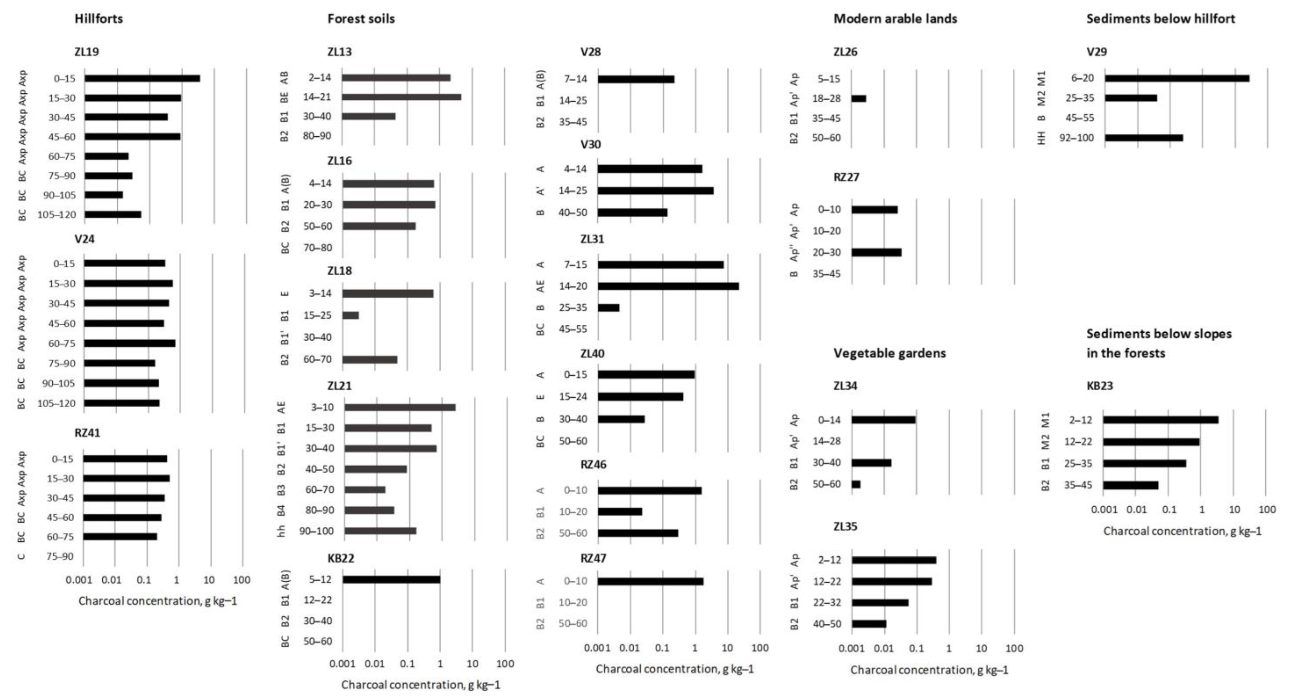
3.1. Soil Description; Charcoals Stratigraphy and Concentration

Charcoal pieces were found in 20 of 22 profiles sampled for the anthracomass determination, in 69 of 94 horizons, and in 180 of 266 samples.
The cultural layer (Axp, topsoil) of all investigated hillforts had a dark coloring due to the abundance of dust and small particles of charcoal. Sometimes, inclusions of burnt stones were found in the cultural layer. The thickness of the cultural layer varied from 50 to 75 cm and from 50 to 80 cm in Zaborovka-Likhusha and Voroshilovo hillforts, respectively, and was about 50 cm in Runa-Zaborovka. The cultural layer was relatively homogeneous in structure and in color to a depth of 50 cm at the inner sites of Zaborovka-Likhusha and Voroshilovo (Figure 2a), and to 30–40 cm in Runa-Zaborovka. According to morphological features, the cultural layers of the hillforts can be classified as Anthropogenic Dark Earth (ADE). ADE is weakly stratified dark-colored soil, usually rich in charcoal and other anthropogenic inclusions [40,41]. The concentration of charcoal fragments larger than 2 mm in size was about 0.5 g kg−1 of dry soil (Figure 3, Table 2). The highest values of maximum (10 g kg−1) and average (1.24 ± 0.55 g kg−1) concentrations of charcoals in the cultural layer were observed in the Zaborovka-Likhusha hillfort. In Voroshilovo, these values were 1.84 and 0.47 ± 0.12 g kg−1, respectively. In the Runa-Zaborovka hillfort, these values were 1.06 and 0.40 ± 0.10 g kg−1. In all the hillforts, charcoals were also found deeper than the ADE layer.
We described two profiles in sediments below hillforts. Sediment profile ZL19 was in the ditch of the Zaborovka-Likhushi hillfort, on its western slope; it was grey-brown sand with charcoal inclusions and consisted of three layers differing in shade: the upper 8–16 cm (M1), the middle 16–35 cm (M2), and the lower 35–49 cm (M3). Sediment profile in the ravine below the Voroshilovo hillfort V29 (Figure 2e) had two layers: the upper 6–20 cm (M1) was dark grey, consisting mainly of charcoals; the lower 25–35 cm (M2) was light grey, with a small number of charcoals. The maximum charcoal concentration (27.3 g kg−1) among all sediment layers was observed in the upper layer below the Voroshilovo hillfort.
Soils under forests located on watersheds and gentle slopes were Albic and Entic Podzols. Twenty-four soil profiles were inspected. Most soil profiles contained an ancient arable horizon with variable color, structure, and thickness. The predominant thickness of the arable horizon was 7–10 cm (Figure 2b,c). Ancient root channels were found in many soil profiles. The number of root channels was relatively small; they were often filled with soil material from the arable horizon, often together with charcoal. According to morphological features, root channels most often were formed by grubbing up relatively small trees with roots up to 30–50 cm deep (e.g., in profiles ZL1, ZL13, ZL18, and ZL31). Patterns of pits from ancient tree uprooting were found in soil profiles ZL1, ZL13, and ZL21; the depth of the pits was mostly 40–80 cm, rarely more than 100 cm. Pits filled with material from E, Bhs, and Bs horizons, almost always with inclusions of charcoals. In profile ZL21, buried humus-type material (hh) with charcoals was found at a depth of 80–100 cm. Charcoal concentration was highest in the ancient arable horizon (often in its lower part), and it was often higher than charcoal concentration in cultural layers of the hillforts (Figure 3, Table 2). Charcoals deeper than the ancient arable horizon were distributed unevenly. Up to a depth of 35–45 cm, charcoals were mainly concentrated in the ancient root channels, less often in small pits from tree uprooting. Deeper charcoals were located in treefall pits. For example, in profile ZL21, three pits of different depths were described on different walls; in the deepest pit (about 100 cm), charcoals were in buried humus material.
We have described six soil profiles in sediments located below slopes in the forest. Sediment profiles mainly consisted of 2 or 3 layers (M) with a total depth of 23–30 cm. Two sediment profiles in the lower part of the moraine hill in the Zaborovka-Likhushi site had 5 layers with a total thickness of 60 cm (ZL20) and 120 cm (ZL14). Layers were formed by different materials. The most common material was colored brown, reddish, and yellow (Bhs, Bs, and C). In profiles ZL12 and KB23 (Figure 2f), layers had dark grey and grey coloration (A material). All layers had charcoal fragments including the lowest 80–120 cm layer in profile ZL14. In three profiles, there were treefall pits under the sediment layers. Charcoal concentration in two layers in sediment profile KB23 (Krasnyi Bor site) was low (Table 2).
In soils of modern arable lands and vegetable gardens, the thickness of the arable layer (Ap) was 22–30 cm; the horizon was homogeneous, brown-grey and brown-dark-grey (Figure 2g,h). The soils were Entic Podzols and Arenosols. In soils of modern arable lands, charcoal was absent in two profiles and in other two, charcoal concentration was the lowest among all the profiles studied (Table 2). In two soil profiles of vegetable gardens, concentration of charcoal was small, but higher than in soils of modern arable lands.
Soil texture was similar in all profiles: sandy fraction content was 91–96%, while the coarse (1–0.25 mm) and medium (0.25–0.05 mm) factions were 60–70% and 18–30%, respectively. Small pebbles often occurred.

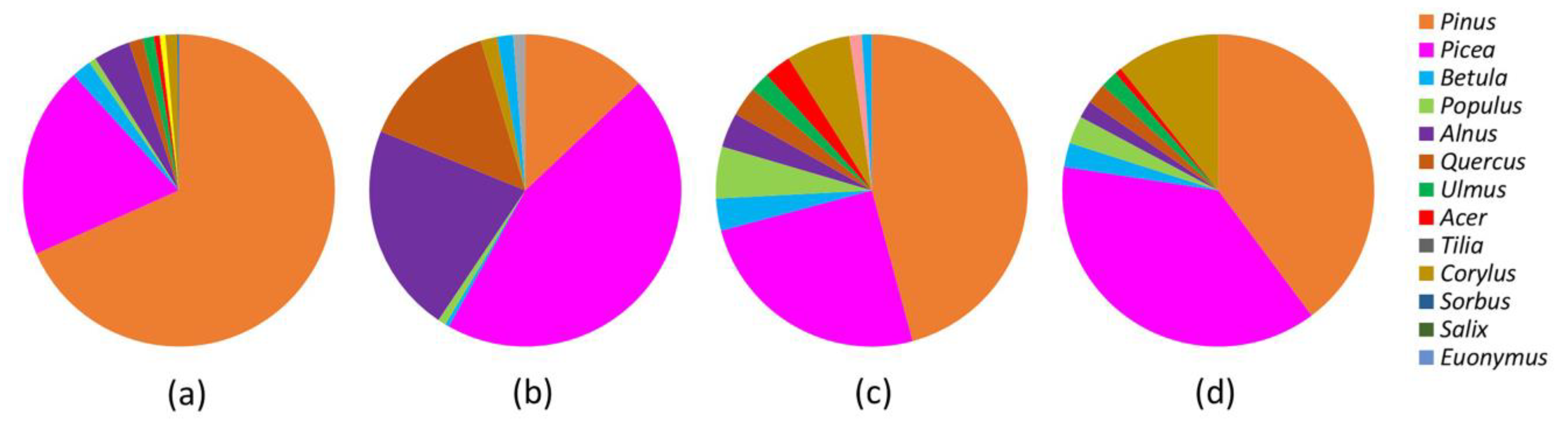
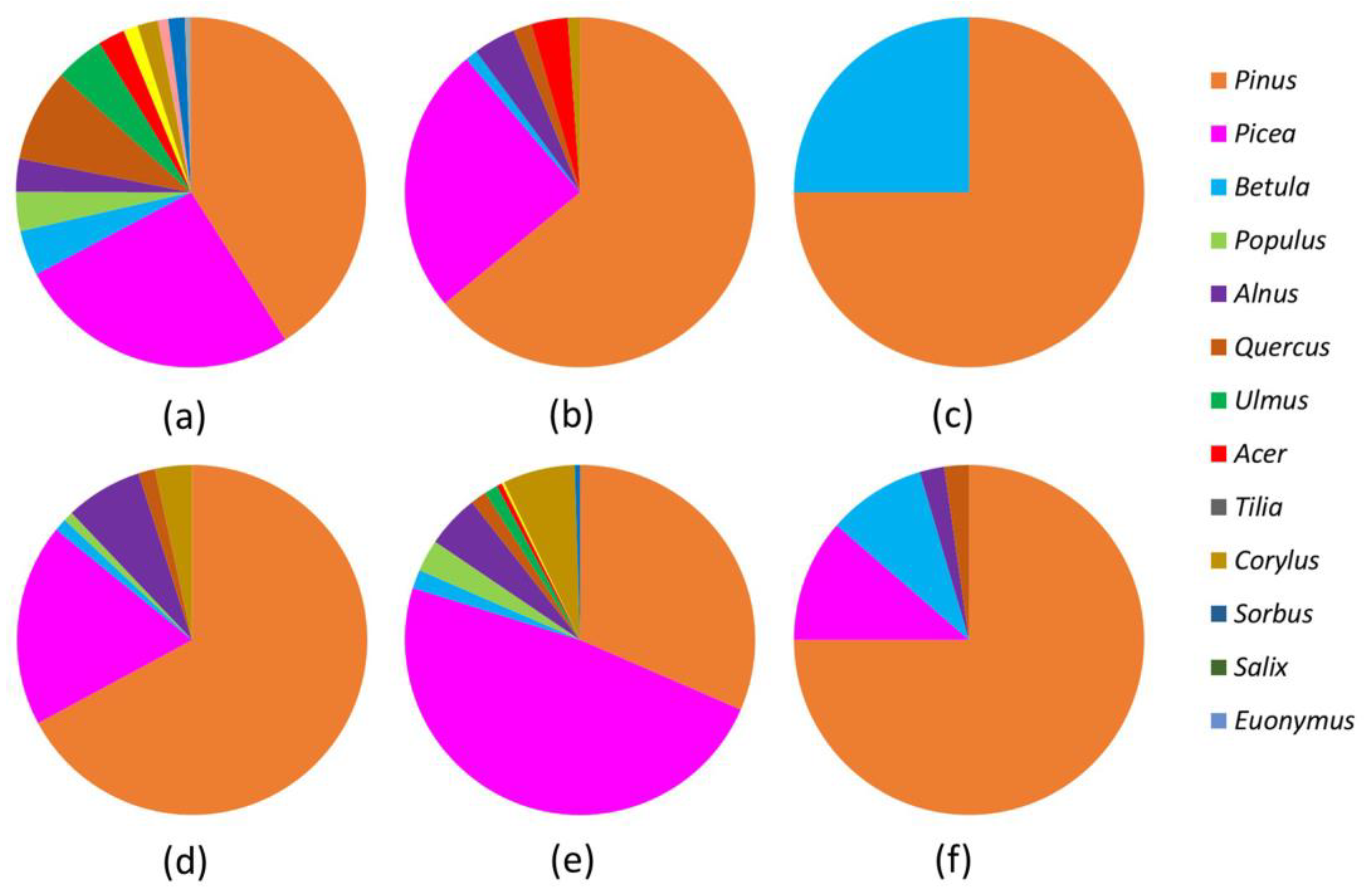
3.2. Taxonomic Composition of Charcoal Record

We extracted 3621 charcoal fragments from 197 soil samples; 119 soil samples were without charcoal. A total of 2277 charcoal fragments were identified; they belonged to 13 woody genera. Charcoal of coniferous taxa dominated: Pinus and Picea accounted for 55 and 26% of all charcoal fragments, respectively. They were followed by Alnus (5.4%), Corylus (3.4%), Quercus (3.2%), Betula (2.2%), Populus (1.8%), and Ulmus (1.3%). Acer, Tilia, Sorbus, Salix, and Euonimus charcoals accounted for less than 1%.
Taking into account the modern and historical distribution areas of tree species [17], the indicated taxa correspond to PinusPinus sylvestris, PiceaPicea abies, CorylusCorylus avellana, QuercusQuercus robur, PopulusPopulus tremula, AcerAcer platanoides, TiliaTilia cordata, SorbusSorbus aucuparia, and EuonimusEuonimus verrucosus. Alnus may correspond to A. incana or A. glutinosa (L.) Gaertn. (black alder), with the latter species now rare in the region; Betula—B. pubescens or B. pendula; Ulmus—U. glabra or U. laevis Pall. (European white elm), both now present in the region, with U. glabra being more common. The genus Salix includes a large number of species.
The total taxonomic richness between the sites varied slightly: in Zaborovka-Likhusha and Voroshilovo, we found 11 taxa each, in Runa-Zaborovka and Krasnyi Bor, 9 taxa each. Shannon diversity index, considering taxa abundance, was less than 1 for all sites, but decreased from Runa-Zaborovka (0.755) to Krasnyi Bor (0.566), Voroshilovo (0.383), and Zaborovka-Likhusha (0.305). At Zaborovka-Likhusha, Voroshilovo, and Krasnyi Bor, Pinus charcoal dominated (68, 46, and 40%, respectively), followed by Picea (20, 25, and 38%) (Figure 4). The proportion of charcoals of “pioneer” deciduous taxa (Betula, Populus, Alnus) was 12% in the Voroshilovo site and about 7% in the Zaborovka-Likhusha and Krasnyi Bor sites. The proportion of charcoals of nemoral (broad-leaved) taxa (Quercus, Ulmus, Acer, Tilia, and Corylus) was 5% in Zaborovka-Likhusha and about 15% in Voroshilovo and Krasnyi Bor. In the Runa-Zaborovka site, Picea charcoals dominated (45%), followed by Alnus (22%), Quercus (14%), and Pinus (13%).
The total taxonomic richness was highest in the cultural layers of hillforts (13 taxa), then in sediments below slopes in the forest (11 taxa). In sediments below hillforts and in forest soils, 7 taxa each were found: in the soil of vegetable gardens and modern arable lands, 5 and 2 taxa were found, respectively (Figure 5). Shanon’s diversity index was highest for sediments below slopes in the forest (0.586), similar for hillforts and sediments below hillforts (0.492 and 0.491), and lowest for forest soils (0.328). Pinus charcoals dominated everywhere, except in sediments below the slopes in the forest where Picea charcoals prevailed.
The proportions of “pioneer” deciduous taxa were very similar in all types of lands (9–11%) except for sediments below hillforts (5%) and in modern arable soils (25%). The proportion of nemoral broad-leaved taxa was greatest in the cultural layer of hillforts (19%), followed by sediments below slopes in the forests (10%). In sediments below hillforts, their proportion was 6%, and in forest soils, 5%. Among nemoral taxa, only Corylus charcoals were found in the soils of vegetable gardens (2.3%). Charcoals of nemoral taxa were absent in modern arable soils.

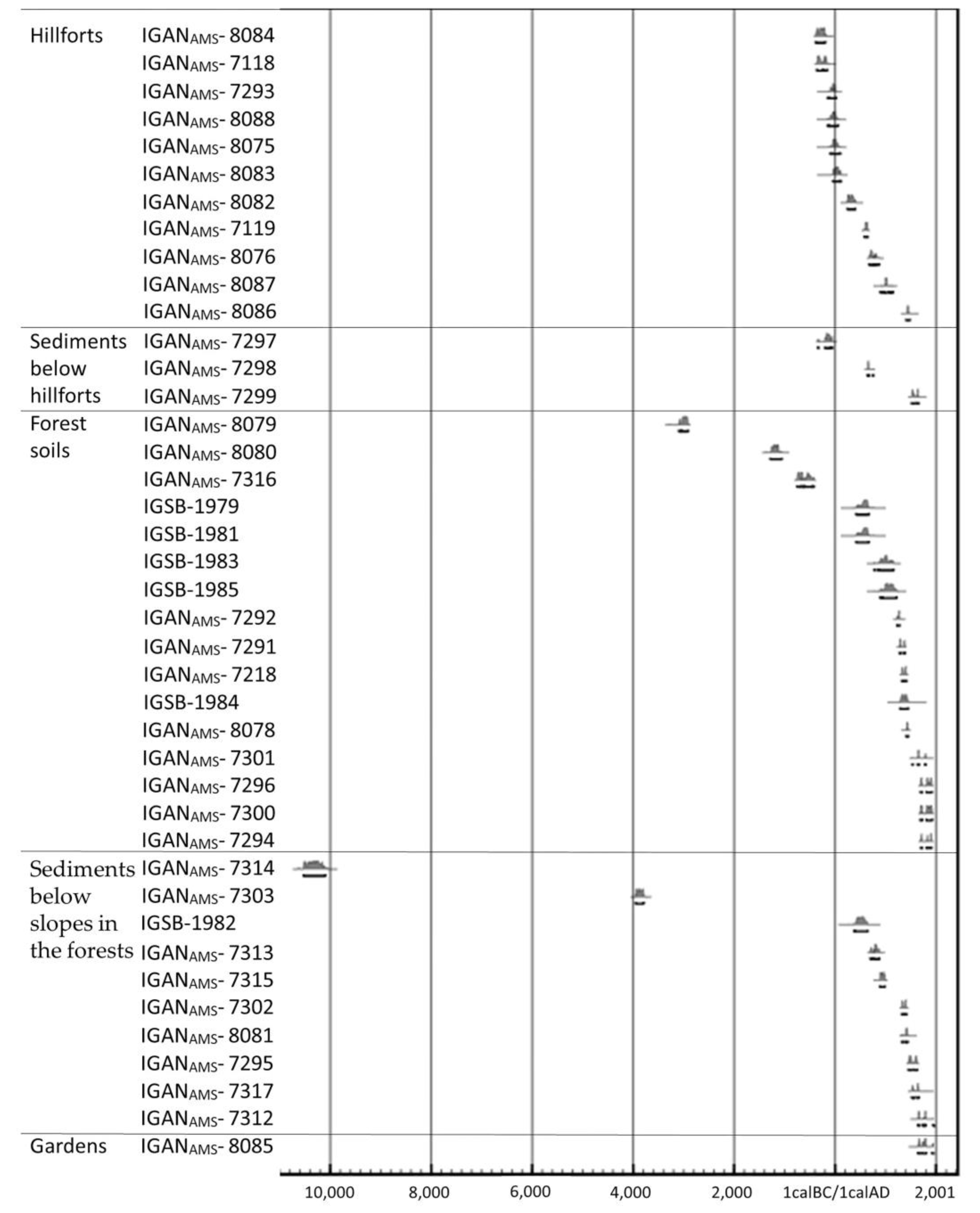
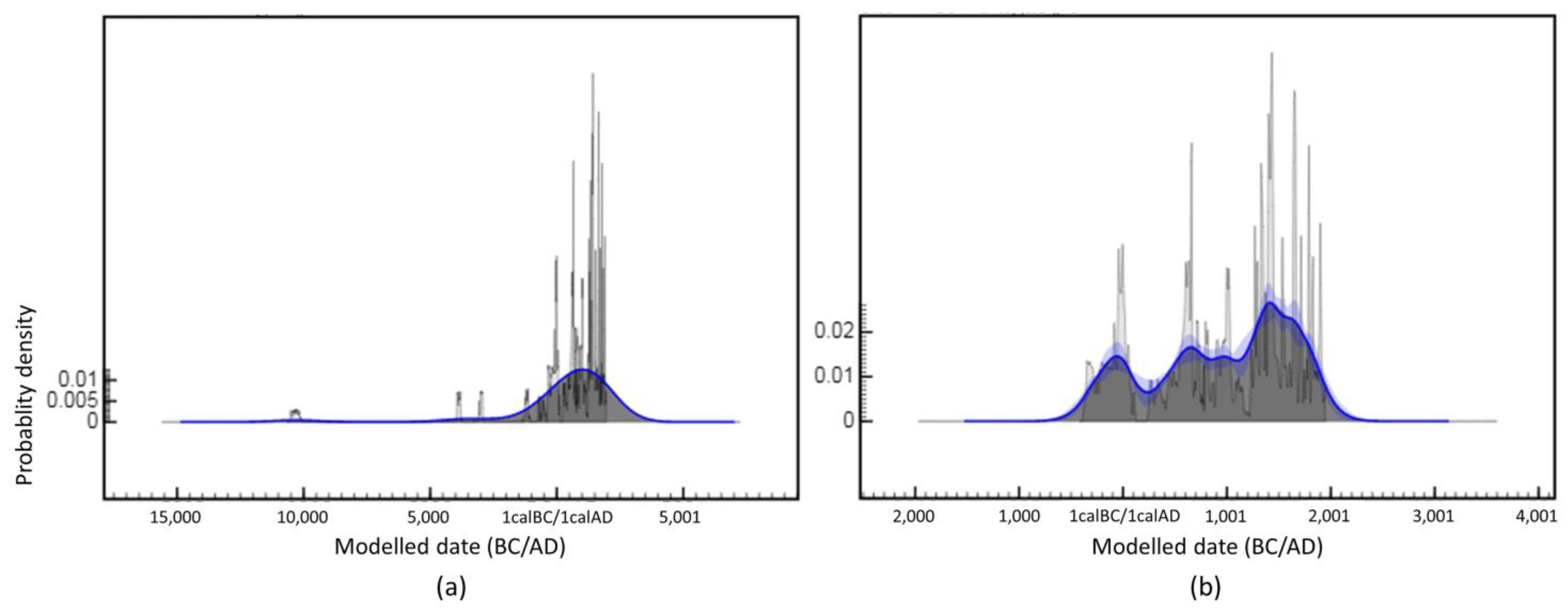
3.3. Radiocarbon Dating of Soil Charcoal Samples

The oldest date, 10,379 ± 170 cal. BC, was determined for charcoal found in the bottom layer at a depth of 120 cm of the sediment profile ZL14 located under the moraine hill in the Zaborovka-Likhusha site. All other charcoals before 500 BC, i.e., before the Early Iron Age (4 samples) were found in treefall pits in forest soils (Table 3, Figure 6 and Figure 7a).
In the Zaborovka-Likhusha hillfort, the oldest date was obtained for charcoal from the burnt wooden structure from the lower part of the cultural layer (at a depth of 55 cm), about 300 cal. BC. The second date (around 160 cal. BC) was obtained from the bottom of the ditch under this hillfort. The third date, belonging to the Early Iron Age (around 10 cal. BC), was obtained here for charcoal at the depth of 15–30 cm. Thus, for the Zaborovka-Likhusha hillfort, the dates within the Early Iron Age were in the interval from the 3rd c. BC to the 1st c. AD. Three more dates fell on the early Middle Ages, 7th–8th cc. AD: two samples from the cultural layer and charcoal from the second (16–35 cm) sediment layer in the ditch. Charcoal from the upper sediment layer in the ditch was dated (cal.) to 16th–17th cc. AD (Table 3, Figure 6).
For the Voroshilovo hillfort, all three radiocarbon dates of charcoals from the cultural layer fell within the interval of the Early Iron Age: around 280 cal. BC, 70 cal. BC, 30 cal. AD. For the Runa-Zaborovka hillfort, the sample with calibrated age from 1st c. BC up to 1st c. AD was collected at 60–75 cm depth below the cultural layer. The calibrated dates of charcoals from the cultural layer at a depth of 15–30 cm corresponded to ca. 11th c. AD, at a depth of 0–15 cm to 15th–16th cc. AD.
Thus, all the charcoals of the Early Iron Age (9 samples) were found in the cultural layer of the hillforts and in the ditch under the Zaborovka-Likhusha hillfort (Table 3, Figure 6).
Charcoals of the 6th century AD were found in the upper layer of sediment profile ZL14 and in root channels with signs of grabbing under ancient arable horizons in forest soils (profiles ZL1 and ZL13). Charcoals of the 8th and 10th centuries were found in sediment profiles ZL14 and ZL20. The 10th–11th century charcoals were found in ancient arable horizons (with very clear signs of ancient plowing) of forest soils (ZL36 and ZL40). All these profiles with charcoal from 6th to 11th centuries were located in forest soils near the moraine hill where the Zaborovka-Likhusha hillfort is situated.
Charcoals of the 13th and 14th centuries were also found in the Zaborovka-Likhusha site: in sediment profile ZL12 and in ancient arable horizons of forest soils (profiles ZL1, ZL31, and ZL49). Profile ZL31 is located on a moraine hill on flattened areas in the upper part of the hill slope.
Charcoals of the 15th and 16th centuries were found in sediment profiles KB4, ZL6, and KB23 and in ancient arable horizons of forest soils (ZL21) at the Zaborovka-Likhusha and Krasnyi Bor sites. Charcoals of the 17th–19th centuries were found at the same sites: in the treefall pit (profile ZL13), in ancient arable horizons of forest soils (profiles KB3, KB5, ZL10, and ZL11), and in the soil of vegetable garden (ZL34). The charcoal under the litter in Krasnyi Bor site (profile KB18) was of recent past.
The modeled age distribution of charcoals for the last 2500 years did not show well-pronounced clusters, while the relatively bright agglomeration of charcoals referred to the Early Iron Age (3rd century BC to 2nd century AD) (Figure 7b). Around the 3rd century AD, there was a gap in charcoals. Next was a cluster in the 4th–12th centuries with highs in the 6th–7th and 11th centuries. There were a minimum number of charcoals in the 13th century. This was followed by a cluster in the 14th-20th centuries with a noticeable maximum in the 15th and 16th centuries.

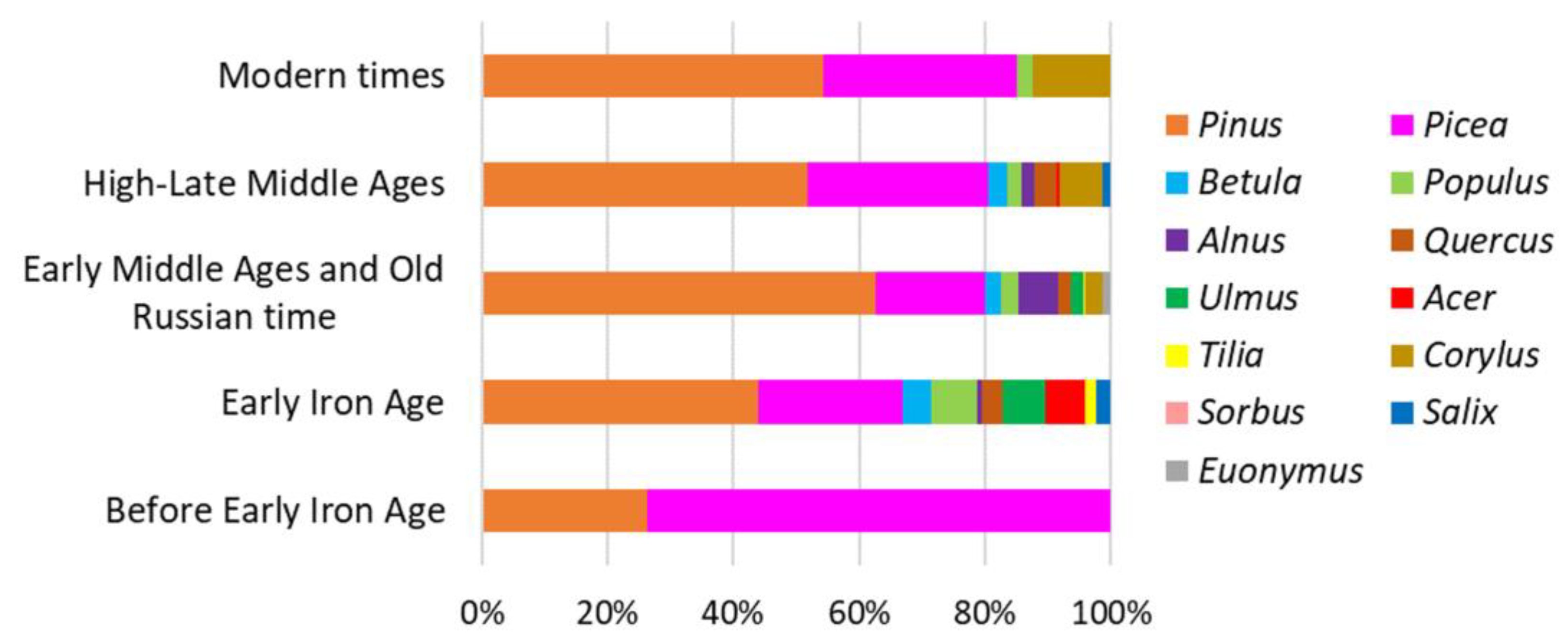
3.4. Historical Dynamics of Woody Taxa

To analyze the dynamics of wood taxa, 39 charcoal samples were classified into five time periods according to their radiocarbon dates. All samples that dated to the Early Iron Age were treated as samples of one period, since there were only five dates, and taxonomic composition of charcoal samples differed slightly. To separate remaining samples, we considered the standard historical periods and relied on the summary curve of the probability of charcoal age. As a result, we analyzed the following periods: (1) before the Early Iron Age to the 5th c. BC, 5 samples (38 charcoals); (2) Early Iron Age, from the 5th c. BC to the 5th c. AD, 7 samples (175 charcoals); (3) Early Medieval and Old Russian, 6th through 12th centuries, 10 samples (251 charcoals); (4) High-Late Middle Ages, 13th through 16th centuries, 11 samples (336 charcoals); and (5) Modern, 17th through 20th centuries, 6 samples (81 charcoals).
Only two taxa, Picea and Pinus, were found for the period before the Early Iron Age (Figure 8). From the Early Iron Age, Pinus predominated, followed by Picea. The greatest diversity of taxa in the dated samples (10 taxa) was recorded in the Early Iron Age, Early Medieval, and Old Russian periods. For High-Late Medieval, 9 taxa were found, and for the Modern period, 4 taxa.
The proportion of deciduous trees was greatest in the Early Iron Age: “pioneer” deciduous taxa accounted for 12.6% and nemoral broad-leaved taxa for 18.3%; here Ulmus and Acer had the highest proportion among all time periods. In the Early Medieval and Old Russian periods, the proportion of “pioneer” deciduous taxa was 11.6% with Alnus dominating; nemoral broad-leaved taxa accounted for 7.2%. In the High-Late Middle Ages, the proportion of “pioneer” deciduous taxa was 7.1%; nemoral broad-leaved taxa constituted 11%, with Ulmus and Tilia disappearing since that time and the proportion of Corylus increasing. In the Modern period, the proportion of “pioneer” deciduous taxa was 2.5% (only Populus was found), while the proportion of nemoral broad-leaved taxa was 12.3%, represented by Corylus only.

4. Discussion

Our results showed that the studied land types differ in their charcoal concentration, stratigraphy, and taxonomic composition. We can consider three periods that essentially differ in these attributes.

4.1. Pre-Early Iron Age: Charcoals in Sediments and Ancient Treefall Pits

The oldest charcoals identified were of genus Pinus, dated 10,380 BC (median probability of 2σ interval, here and thereafter). They were located in the lower layer of the deepest sediment (120 cm thick) found below the moraine hill at the Zaborovka-Likhusha site. The sediment was formed as a result of erosion slightly earlier than the standard Holocene boundary. Kappler et al. [42] date the oldest erosion phase for Central Europe to 9000–7000 BC. A combination of cold and dry climatic conditions with increased frequency of wildfires was considered as its possible cause. We extend this assumption to our case.
The next four dates were associated with the finds of charcoals in ancient treefall pits. Only one taxon (Picea or Pinus) was present in each sample. We believe that the poverty of the taxonomic composition of charcoal in a single sample is a characteristic feature of samples formed after wildfires, when the probability of finding nearby charcoals of many woody species is low, unlike the intentional gathering of trunks of different species in one place at artificial burning. Pinus charcoals dated to around 3870 BC, and Picea dated to around 2980, 1190, and 610 BC. Before the Early Iron Age, the movement of charcoals from fires into the mineral soil was sporadic, with only relatively rare events of treefall with uprooting. The main mass of charcoals after fires was probably transported with water erosion or burned during subsequent fires. Therefore, it is impossible to reconstruct the full history of local fires from the charcoals found in the ancient treefall pits. However, the dates may reflect the minimum frequency of large fires on the moraine hill in the Zaborovka-Likhusha site, where soil profiles with charcoal in ancient treefall pits were located.

4.2. Early Iron Age: Charcoals in Dark Earth on the Hillforts

In the dark cultural layers of the hillforts (ADE), the concentration of charcoals larger than 2 mm was unexpectedly low. Obviously, this was a consequence of the destruction of charcoals and the predominance of charcoal of a finer fraction. The concentration of the studied large charcoal pieces did not directly correlate with the color intensity of the cultural layer, which was seemingly determined by the concentration of the finer fraction of charcoals.
As far as we can judge from the cores, the upper layer of the ADE of the studied hillforts was quite homogeneous in structure and color up to a depth of 50–80 cm. As at many sites of the Dyakovo culture [43] and at later archaeological sites with similar soils [44,45], the Early Iron Age layer could be overlapped by later cultural layers. The thickness of the cultural layer varies greatly. For example, in Gnezdovo, the thickness of ADE soil ranges from 20 to 150 cm [44,46].
The nearest hillforts investigated by archaeological excavations are Sterzh (Novinka) [47,48], Nechai Gorodok [15,47,49], and Nikola Rozhok [17,49] on the Volga River and Kurovo 1 [50] on the Western Dvina River. At all these sites, the cultural layer is dark-colored, up to 1 m thick, and presumably can be also classified as Anthropogenic Dark Earth. Traces of iron production were found in the cultural layer of the Sterzh, Nikola-Rozhok, and Kurovo 1 sites: forge hammers (stone furnaces coated with clay), iron ingots, and slags. The remains of two dwellings were also found at the Nikola-Rozhok site. Based on the results of these excavations, archaeologists have interpreted these hillforts as places of stationary settlements that were often combined with metal production. Most likely, the sites that we studied were used in the same way.
The presence of charcoals deeper than the dark layer in the studied hillforts may be the result of (1) the content of charcoals in the material of the artificial mounds used for hillforts that were created at the site or (2) the multilayer structure of the cultural layer. We assume the second variant. First, the yellow-brown cultural layer with inclusions of unshredded charcoals was formed. Then, the Dark Earth was formed above it or in its upper part as a result of the inflow, crushing, and mixing of charcoals. Confirmation of this assumption requires further research.
ADEs are often part of a multi-layered “cultural layer”, such as urban ADEs, which are quite widespread [51,52,53]. ADE can also be overlain by later deposits: this is observed at many sites of the Dyakovo culture [43] and at later archaeological sites with similar soils [44,46]. In general, ADEs are common in settlement areas throughout much of Europe [54,55,56]. They are sometimes called “Baltic black earths” in northern Europe [57,58]. The development of these soils began between 3800 and 2000 BC [57] and spans the Roman to Medieval period [59,60]. In Northern Europe, the development of most ADE is attributed to the Viking and Northern Slavic economies in the 1st millennium AD [40].
The peculiarity of ADEs in the studied hillforts is that they are not buried soils; they are located on the day surface of modern soils. The Zaborovka-Likhusha, Voroshilovo, and Runa-Zaborovka hillforts are also characterized by the absence of obvious signs of late anthropogenic impact as well as the presence of forest at these sites for at least the last few centuries. Both the age of charcoals in the cultural layer and the archaeological findings (primarily textile pottery [14]) show that the main thickness of the ADE at the hillforts of Zaborovka-Likhusha and Voroshilovo was formed in the Early Iron Age (about the 3rd c. BC the 2nd–3rd c. AD). The time of ADE formation here was probably hundreds of years.
Charcoals of the same time (which appeared for the first time after 10 thousand years BC) were found in sediments, suggesting the presence of soil erosion at this time and its absence earlier. The sediments near the Voroshilovo settlement refer to approximately the same time. There was a high concentration of charcoals in the sediments below hillforts; charcoals were accumulated here and probably were not subjected to destruction in the later period. Soil erosion indicates an active anthropogenic transformation of the territory of the sites.
The highest diversity of woody taxa was found in the cultural layers of the hillforts compared to other land types. Pioneer Betula, Populus, Alnus, and nemoral broad-leaved trees; primarily Ulmus and Acer, but also Quercus and Tilia. Here alone, we found charcoals of Sorbus and Euonymus (Figure 5a). As was noted above, the occurrence of a large number of taxa in a small volume of a soil sample is an attribute of intentional wood burning or an artificial “concentration” of species.
The principle of least effort [61,62,63], which assumes that the frequency of charcoal directly reflects the abundance of woody taxa, is often used to interpret charcoal finds. However, charred remains are the end result of a variety of human activities [64]. Hence, archaeological charcoals are not haphazardly distributed solely as a result of climatic and environmental conditions. For example, Jakobitsch et al. [65] showed the selective use of spruce timber only for pillars in mines when spruce dominated the surrounding forests.
In our study, it is likely that most of the charcoals found in hillforts and in sediments below hillforts were firewood; some (probably very small) part may have been burnt buildings. The use of Acer and Ulmus, especially the latter, as firewood is not easy or cost-effective. However, wood of these species can be used for this purpose (on a par with Quercus) when it is necessary to obtain high flame temperatures, for example, in the smelting of metals. Traces of metal production were found in other hillforts in the region [14], and they are also very probable for the hillforts we studied, at least for Zaborovka-Likhusha and Voroshilovo.
If we assume that the composition of charcoals generally reflects the composition of the vegetation, we can suggest a rather high complexity of the vegetation surrounding the hillforts. The large number of pioneer species capable of recovering from extensive disturbances were present simultaneously with almost all late successional species. In part, these species assemblages may have been spatially separated: for example, dominant pines could grow in higher elevated and drier areas, late successional tree species in wetter depressions, and in the undergrowth in pine forests. In general, this composition of woody species indicates a mosaic of the landscape: not all the territory was uniformly subjected to significant anthropogenic impact, such as burning, intensive grazing, and even more so, plowing.
Analysis of data from the Krivetskiy moss bog located not far from our study area (about 1 km to the Krasnyi Bor site, about 4 km to the Runa-Zaborovka and Zaborovka-Likhusha sites, and 17 km to the Voroshilovo site) showed that Picea abundance experienced two declines within the period 600 BC–100 AD, which coincided with increased proportions of Betula and Alnus (and a corresponding decrease in deciduous Tilia, Quercus, and Ulmus) [16]. The pollen record suggested the rise of herbaceous plants, such as Artemisia and Plantago, indicating human exposure through cattle husbandry at this time. It was also shown for the southern Valdai Uplands that the abundance of plant species preferring wet conditions (Equisetum, Menyanthes trifoliata L., and Cyperaceae) has increased since 100 AD, which might indicate the expansion of wetlands [66]. From this time, the activity at the hillforts decreased and probably ceased temporarily. After the maximum from the 3rd c. BC to the 1st c. AD, the model curve shows a minimum probability of the presence of charcoals from the 2nd to 4th centuries AD (Figure 7).
The signs of agriculture in pollen spectra for the hemiboreal forest region of the Eastern Europe have been noted since the Neolithic and Bronze Age (5000–4000 BP) [67,68,69,70,71,72,73,74]. In the Early Iron Age, palynological indicators of farming occurred more frequently and became more stable. For the Polistovo-Lovatskaya bog system (Pskov Oblast), cultivated cereals appeared at 2500 to 2000 BP [75,76]. In the Staroselskiy moss bog, a continuous Cerealia curve begins at 1700–1600 cal BP [77,78,79]. East of Lake Ilmen (Novgorod region), cultivation of cereals was attributed to 2500 BP [80,81]. The presence of grain farming is also assumed for the Dyakovo culture [82]. Based on the results of studies of the surroundings of the Dyakovo hillfort [43] and the surroundings of the Busharino hillfort [83,84] (Moscow Region), the presence of permanent arable lands, shift and slash-and-burn agricultural systems is assumed here.
For the region we study, there is still no evidence to confirm the presence of agriculture in the Early Iron Age. For this time, charcoals were found only in the cultural layers of the hillforts and in the sediments below them. There were no traces of burning, plowing or erosion of this time period for soil profiles studied in all other land types.

4.3. From Medieval to Modern Times: Charcoals in Forest Soils

An arable horizon in the upper part of soil profile is the main sign of past agricultural cultivation of soil (e.g., [30]). It is generally assumed that signs of plowing, including the characteristic lower boundary of the plowing horizon (“plow sole”), can persist in forest soils for several hundred years. Although these features are thought to be obliterated by bioturbation by soil fauna over about 200 years [85,86], in sandy soils with low soil fauna activity, these traits may persist for hundreds and probably thousands of years [29,87,88,89].
The signs of ancient plowing are most quickly destroyed by subsequent plowing, especially given the increasing depth of plowing over time. Simultaneously, the destruction of charcoals is likely to occur. This can be the reason for the small number or complete absence of charcoals in the upper horizons of modern arable soils, registered in this study. Therefore, to study the ancient arable horizons, one must look for areas that were used for tillage and subsequently abandoned and still are under forest vegetation. This is the paradox: traces of ancient plowing should be sought in the oldest forests, in long-forested areas.
In all the studied profiles of forest soils, we noted an ancient plowing horizon, the structure and thickness of which varied. The predominant thickness of the ancient arable horizons was 7–10 cm, which corresponds to the depth of tillage with such ploughing tools as wooden harrows and primitive ards, including forked ards [88,90]. The thickness of the arable horizons of modern arable lands and vegetable gardens is notably greater, 24–30 cm.
We found the bulk of the charcoals in the forest soils in the upper horizons A, AB, AE, E to a depth of 15 cm, rarely 20 cm (Figure 3). Here, their mean concentration was 3.63 ± 1.19 g kg−1, which is almost 5 times higher than in Dark Earth and 30 times higher than in deeper horizon B (Table 2). Concentrations of charcoals in the forest soils in this study was several times lower than in the previously studied sandy soils of Ryazan region, where the average concentration of charcoals in the upper horizons for different sites varied from 8.1 ± 5.8 to 25.8 ± 30.7 g kg−1 [29].
We attribute charcoals in the sediments in the forests primarily to ancient burning and plowing. The features of the material in the sediments studied (first of all, the coloration) corresponded to the material of the arable horizons on the upland positions of the terrain. In some cases (e.g., at the Krasnyi Bor site), the soils on moraine ridges showed signs of degradation (washout) of the upper part of the profile: the upper horizon on the hill was represented by poorly developed AB, while the sediments under the hill contain well-humusized material A.
Many studies have shown that in many European territories, the greatest increase in erosion occurred during the initial deforestation of the territory when it was developed for arable farming [91]. The spatial and temporal correlation of the main phases of sedimentation with archaeological evidence points to agricultural land use as a determinant of colluvial deposition, at least since Roman times [92]. In addition, we assume that wildfires generally have had little effect on soil erosion in the study area, as was already shown by Carcaillet et al. [93] for the forest ecosystems of Eastern Canada.
Early Middle Ages and Old Russian time. The first signs of arable farming in the region we noted at the beginning of the Early Middle Ages. The charcoals of the 6th–7th century were found in the upper sediment layer, in root channels with signs of uprooting (grubbing) under ancient arable horizons in forest soils. Morphology and stratigraphy of charcoals in the profiles (traces of grubbing with charcoals under arable horizon) showed their association with burning and the subsequent use of arable implements.
The charcoals of the 8th century were found in the sediment under the moraine hill, which may be related to the clearing of the forest on the ridge; erosion activity at the Zaborovka-Likhusha hillfort was noted for the same time. The mounds at the top of the moraine ridge also belong to the second half of the first millennium. Mounds were usually made in the open space. The combination of erosion and human activity on the hilltop can indicate that the creation of the mounds dates to this period, but it can also be attributed to a later period. On the ridge below the mounds, there are flattened areas, which we assume to be an ancient arable land. However, the age of the charcoals in the studied profiles at these sites attribute them to a later time. The charcoals in the arable horizons in the profiles with very clear signs of ancient plowing dated back to the 10th–11th centuries. Charcoals in sediments were also found for this time. Patterns of the charcoal accumulation at the Runa-Zaborovka hillfort indicate an increased activity at the same time.
The Early Middle Ages and Old Russian time is a period of significant changes in the composition of vegetation according to regional spore-pollen spectra [16]. A sharp decrease in the abundance of Picea and an increase in the proportion of Alnus was noted at 510–570 AD. Usually, the increase in abundance of Alnus is associated with an increase in moisture and waterlogging of the territory. However, gray alder (Alnus incana) can successfully grow on watersheds, and we found it on moraine hills. In northwestern European Russia, it actively occupies abandoned agricultural lands [17].
In our study, the soil charcoal spectrum for this time showed a marked increase in the proportion of Pinus and Alnus, primarily due to a decrease in the proportion of nemoral broad-leaved woody taxa (Figure 8). The increased distribution of Pinus and Alnus may indicate shifting of the farming systems.
The appearance and spread of farming in the studied region are most likely associated with the Pskov Long Barrows culture, which was distributed in the region since the middle of the first millennium AD. There are a large number of archaeological monuments of this culture in the region (villages and barrows) [14,94,95,96]. Archaeological layers of these sites include pollen of cultural cereals [97].
After a fairly large number of finds indicating the development of farming and soil erosion in the 6th–11th centuries, there was a decrease in the model probabilities for charcoals in the 12th–13th centuries (Figure 7). This may indicate both a decrease in anthropogenic activity and the absence of new clearings and the existence of permanent plowing after the transition from the cultures of the second half of the 1st millennium to the Old Russian time.
High-Late Middle Ages. For the next period, the High-Late Middle Ages, significant clearing activity was noted in the 13th–14th centuries (Figure 6 and Figure 7). Charcoals from this period were also found in the old-arable horizons in forest soils and in the sediment in the Zaborovka-Likhusha site. Two soil profiles were located on flat areas in the upper part of the moraine hill. In our data, this was the earliest reliable evidence of burning and subsequent use of a plowing tool on the moraine ridge. We assume that over this period of clearing, at least some areas were used as permanent arable land for a long time (in one case, with probable signs of fertilization: Figure 2d). During this time, a very distinguishable arable horizon with material markedly different from both the B horizon and arable horizons of earlier times was formed. Few charcoals were preserved in such old plowing horizons; Pinus charcoals absolutely dominate in composition.
Charcoal from the 15th–16th centuries was found in ancient arable horizons and in sediments below slopes in forests in the Zaborovka-Likhusha and Krasnyi Bor sites (Figure 6). Four of the six profiles were in forest sediments likely due to increased erosion during this period and the active use of high relief positions for agriculture. We obtained a relatively large number of dates for the 15th–16th centuries (Figure 7), in the “Time of Troubles” in Russia, when there was a decline in agricultural activity in many other regions of European Russia. It can be assumed that the territory under study, which was located in a rather “deaf” place outside the territory of the destroyed Novgorod Republic, served as a place of emigration of refugees from the territory affected by the Troubles. Probably, the decline in agricultural activity took place here in a later period.
Note that, for the middle and southern parts of Germany, more than one-third of the sediment dates are from the last 800 years, which potentially proves the large-scale human alteration of the landscapes of these regions during medieval colonization [98]. In general, in Central Europe, the period from the 12th to the 15th century is characterized by very high erosion rates and intensive accumulation of colluvial deposits [99]. In our study, during this period, the proportion of Picea and Corylus, as well as Quercus, increased markedly in the taxonomic spectra of charcoals at the expense of the participation of Pinus and Alnus.
In earlier studies, the increased involvement of Picea was often interpreted as the absence of anthropogenic impacts, evidencing the formation of late succession forests. However, now the expansion of Picea is increasingly seen as a consequence of the spread of agriculture [100]. Farming leads to the reduction of the areas occupied by all tree species. In the studied region, pioneer species such as pine, birch, and grey alder are the first to settle on abandoned arable lands. After them, spruce settles more successfully than nemoral broad-leaved trees due to the relatively large seed dispersal distance and undemanding to soil conditions. In the region, this situation is typical of the last centuries as well, while the expansion of spruce into drained habitats is restrained by wildfires.
According to the pollen data, after 1300 AD, the proportion of non-arboreal pollen (Artemisia, Rumex, Poaceae, and Chenopodiaceae) steadily increased, indicating the reduced forest cover in the region and arable area expansion [16]. The decline of Picea and Pinus is also observed, as well as of broadleaved trees with the corresponding rise of Alnus.
Modern Period. For the Modern period, we found only a few samples. Charcoals of the 17th- and 18th-century were probably associated with clearing of forest lands for plowing (one sample was found in the vegetable garden). Two charcoal samples of the 19th and 20th centuries were probably also associated with clearing and the third with wildfire. No charcoal of the modern times was encountered in sediments.
This period is characterized by a poor taxonomic composition of charcoals, generally corresponding to the modern composition of woody vegetation: compared to the previous period, the shares of Pinus and Picea were preserved, and the share of Corylus significantly increased; charcoals of Populus was also found.
From ca 1600 AD, the plant communities in the region featured various taxa indicative of anthropogenic disturbance, erosion, and grasslands [66], including Centaurea cyanus L., Plantago, Artemisia, Chenopodiaceae, Asteroideae, Cichorioideae, Rubiaceae, and Poaceae. However, in our study area, no diverse anthropogenic indicators were detected by pollen data, and there were no cereals found in the area [16]; these facts indicate the low intensity of land use in the region. A large decline in the population and economic activity in many regions of north-west of European part of Russia occurred between the 16th and 18th centuries, probably due to the climate cooling [75,76,79]. According to the historical reconstruction by Mazei [16], the period with minimal values of temperatures (2.4–2.6 C lower than today) was between 1638 and 1754 AD and coincided with the so-called ‘Little Ice Age’ period.
Perhaps, a small number of the pollen indicators of anthropogenic impacts in [16] were due to the fact that the studied bog was located far from historical villages. Smirnov et al. [14] showed that the nearest Medieval burial site (9th–13th AD centuries) was situated at least one kilometer from the studied bog.
Thus, based on the analysis of soil profiles including sediments, we can assume the spread of arable farming in the study area since the 6th century. The question remains open whether there was slash-and-burn farming in the area (local region) before the 6th century. This cannot be excluded, since we might not have seen its traces, or they were destroyed by later plowing. However, we have not encountered sedimentary deposits and charcoals in sediments earlier than that time. This is important because many studies have shown that the burning of a forest area during slash-and-burn agriculture leads to soil erosion [101,102]. Accordingly, the absence of erosion (and sediments) indirectly indicates the absence of farming in the region.
Our results do not allow us to identify the farming systems used in different periods. However, some assumptions can be made. First of all, starting from the 5th century and throughout the next 1500 years, there was continued burning and plowing in the area; in most of the studied soils, charcoals were preserved within the ancient arable horizons. This fact indicated that long-term stable farming was absent in the local area. The studied sites are not located near known past or modern large settlements, and we assume that a shifting cultivation system dominated here. Under this system, a plot was used for a relatively short time (usually up to 10–20 years) without significant concern for soil fertility (there was no or extremely rare fertilization), and then the plot was abandoned for several decades. In historical times, the duration of periods of use and abandonment was 10–20 years each [92], but in prehistoric times, it could vary greatly.
The process of erosion (sedimentary accumulations) is a particular indication of ancient burning and plowing. Since the Early Neolithic, a discontinuous distribution of colluvial sediment ages with several peaks (from two to five or more), indicating many phases of erosion, has been shown for middle and southern Germany [98] as well as for southwestern Germany [103]. We found a single case of pre-Holocene erosion and sediments under the Early Iron Age hillfort while most sediments in the study area were formed in the Middle Ages. It should be noted that there is a break in the 11th–13th centuries and no evidence of erosion (or dated charcoal samples) after the 16th century. The land-use map of Russia developed in the middle of the 19th century [104] shows all of the studied areas as forested. It is likely that a land-use structure was developed in the 14th–16th centuries in which there were vegetable gardens and permanent arable land near the settlement, while areas of shifting and slash-and-burn systems remained elsewhere [105]. This system was mainly abandoned in the 19th and early 20th centuries. In regions with high populations, all arable lands became permanent, while in the region under study, much of the former rotational farming lands have been abandoned.

4.4. Tree Taxa Composition: Richness, Distribution, and Dynamics

Among the investigated land types, the hillforts were distinguished by the highest taxonomic richness of charcoals: 13 taxa of woody species, including almost all tree species presently occurring in the Upper Volga (except Fraxinus), were found here. The high tree richness in hillforts was probably due to the fact that woody species were artificially concentrated in the burn areas. It is likely that the forest burning for the clearing of arable land also involved the collection of trees of various species, but at a much smaller extent compared to hillforts, and at brief temporal episodes. This is consistent with the fact that seven taxa of woody species were encountered in modern forest soil. Only three woody taxa, Pinus, Betula, and Sorbus were found in the ancient arable horizons of sandy soils in the Ryazan region [28], although the concentration of charcoals was several times higher. Compared to forest soil on levelled surfaces, forest sediments below slopes additionally aggregated charcoal of different species as a result of repeated inputs of charcoals from arable lands over a longer period of time (from several clearings). We attribute the poverty of taxa in modern arable lands and vegetable gardens to the low concentration of charcoals due to their destruction under repeated agricultural impacts.
The total taxonomic richness differs insignificantly between the sites, despite the fact that at the Krasnyi Bor site, there are no hillforts, the cultural layer of which is the richest in taxa. The difference in the taxonomic composition between the sites is probably determined primarily by the landscape features, the relief features, and moisture regime determining the probabilities of the wildfire spread. Thus, the difference of the Runa-Zaborovka site from the others in the Picea predominance with relatively small participation of Pinus can be explained by the protection of the site from the fires. The site is actually an island that is isolated by the stream and damp depressions.
The diversity of tree taxa in the local area is high for the southern taiga region, as pine forests with a relatively poor species composition dominate now in the area [17,106]. It was a surprise that Quercus and Corylus charcoals occurred more frequently than charcoals of pioneer deciduous tree species such as Betula and Populus. This is atypical for water–glacial landscapes of European Russia [28] where oak and hazel occur more rarely than birch and aspen. Quercus and Corylus do not sustainably regenerate in broadleaved forests, even with a gap mosaic, but successfully colonize abandoned meadows and forests dominated by pioneer tree species such as Pinus and Betula [17]. The abundant presence of Quercus and Corylus in the charcoals indicates both a wider distribution of these species in the past and possibly the intentional nature of their burning by humans when clearing land for crops or firewood, rather than burning as a result of wildfires.
The greatest number and the highest proportion of nemoral broad-leaved taxa, as well as deciduous trees in general, were observed for the Early Iron Age. The purposeful use of these species in the region at this time can be assumed. In the High-Late Middle Ages, Ulmus and Tilia disappeared from the spectra, and the taxa richness decreased greatly with the transition to the Modern period. These changes were probably related to the targeted removal of nemoral taxa as a result of selective logging. However, we hypothesize that the main reason was the high frequency of fires, which are disastrous for broad-leaved species. Grass fires often occur on abandoned land after plowing [107], after which pine spreads easily (especially on the sands) and the likelihood of forest wildfires increases. This is confirmed by the fact that the concentration of macrocharcoal in the peat deposits increased about 500 years ago, and remained high until recent times [16]. Frequent fires probably shaped the modern composition of the woody vegetation.
In Europe, a decrease in species diversity or even a complete change of species complexes based on the results of studies of charcoals in soils and archaeological sites is often registered [108]. This is especially true in mountainous areas [7,109,110]. Examples from loess areas in southern Poland [111], lowlands in the Czech Republic [112], and south-east Norway [99] show significant differentiation in taxon dynamics between different landscapes and the presence of tree species migrations. Tilia and Acer are also reported to disappear at Mirambel Woodland (Limousin, Massif Central, France) at a local scale [113]. In our study area, there were no catastrophic changes in the species composition or migrations of woody species in the Late Holocene. All species encountered in the charcoals were present in the region. However, maple and elm were absent in the local area. Our study supports the idea that during the Late Holocene, local gaps were formed in the ranges of nemoral broad-leaved species, resulting in changes in the proportions of taxa in the forest vegetation. Boreal-nemoral forests turned into southern taiga forests [17].

5. Conclusions

This study showed the differences between various land types in terms of the information that can be extracted by pedoanthracological methods. Land types differed in the stratigraphy of the charcoals, their concentration, and taxonomic composition. This suggests that in order to reconstruct vegetation dynamics, it is methodologically important not to limit the study of charcoals in the soil to only one type of land, but to investigate their different variants.
The main ways of moving charcoals into soil mineral horizons differed among the land types: anthropogenic pedoturbations were evidently the main ones in the hillforts; transport as a result of erosion and accumulation prevailed in sediments, while burial of wood burnt on the surface into root channels during tree grubbing, and into arable horizons by plough tools likely prevailed in forest soils with ancient arable horizon. In addition, in all land types, it was possible to find results of charcoal moving as a result of phytoturbations, i.e., in the pits after treefall with uprootings.
The study showed changes in the composition of woody taxa over time under human impacts. In fact, most of the charcoals were the result of the intentional burning of wood in the hillfort areas or forest clearing for arable lands. These two main sources of charcoals (Dark Earth in hillforts and forest soil with ancient arable horizon) were separated in space and by the time of charcoal accumulation. The maximum accumulation of charcoals in the cultural layer of the studied hillforts was found for the 3rd c. BC–1 c. AD. The maximum abundance of woody taxa and the highest proportion of nemoral broad-leaved taxa were observed for this time. Except for the activity in hillforts, no other signs of anthropogenic activity have been recorded for the Early Iron Age.
In the study area, we reconstructed the 6th century AD as the time of the beginning of forest burning for plowing and further use of arable implements. Probably, the beginning of arable farming in the region is connected with the spreading of the Pskov Long Barrows culture. Signs of arable farming in forest soils and in sediments were well-expressed in the 10th–11th and then in the 14th–16th centuries. In the High-Late Middle Ages, Ulmus and Tilia disappeared from the taxonomic spectra of charcoals, and the taxon richness decreased significantly with the transition to the Modern time. At this time, forests become less mixed (coniferous–broad-leaved) and more boreal.

Supplementary Materials

The following supporting information can be downloaded at: https://www.mdpi.com/article/10.3390/d15030403/s1, Table S1: Taxonomic composition of soil charcoal, Table S2: Charcoal concentration in soil.

Author Contributions

Conceptualization, A.V.T., M.V.D. and M.V.B.; project administration, M.V.B.; fieldwork, M.V.B., D.A.K., A.L.S., L.G.K., M.V.D. and A.V.T.; charcoal analysis and interpretation, D.A.K. and M.V.B.; archaeological background and interpretations, M.V.D. and A.L.S.; data curation, analysis, and visualization, L.G.K., M.V.B. and A.L.S.; M.V.B. wrote the first draft of the manuscript, to which all authors contributed with text, comments, and ideas. All authors have read and agreed to the published version of the manuscript.

Funding

This research was supported by Russian Science Fund grant number 22-28-01761.

Institutional Review Board Statement

Not applicable.

Data Availability Statement

The data presented in this study are available in supplementary material.

Acknowledgments

We are grateful to Georgy Lekarev for his help in fieldwork, support, and hospitality.

Conflicts of Interest

The authors declare no conflict of interest. The funders had no role in the design of the study; in the collection, analyses, or interpretation of data; in the writing of the manuscript, or in the decision to publish the results.

References

  1. Carcaillet, C.; Thinon, M. Pedoanthracological contribution to the study of the evolution of the upper treeline in the Maurienne Valley (North French Alps): Methodology and preliminary data. Rev. Palaeobot. Palynol. 1996, 91, 399–416. [Google Scholar] [CrossRef]
  2. Nelle, O.; Robin, V.; Talon, B. Pedoanthracology: Analysing soil charcoal to study Holocene palaeoenvironments. Quat. Int. 2013, 289, 1–4. [Google Scholar] [CrossRef]
  3. Talon, B.; Payette, S.; Filion, L.; Delwaide, A. Reconstruction of the long-term fire history of an old-growth deciduous forest in Southern Québec, Canada, from charred wood in mineral soils. Quat. Res. 2005, 64, 36–43. [Google Scholar] [CrossRef]
  4. Cunill, R.; Soriano, J.M.; Bal, M.C.; Pèlachs, A.; Pérez-Obiol, R. Holocene treeline changes on the south slope of the Pyrenees: A pedoanthracological analysis. Veg. Hist. Archaeobot. 2012, 21, 373–384. [Google Scholar] [CrossRef]
  5. Robin, V.; Nelle, O. Contribution to the reconstruction of central European fire history, based on the soil charcoal analysis of study sites in northern and central Germany. Veg. Hist. Archaeobot. 2014, 23, 51–65. [Google Scholar] [CrossRef]
  6. Ohlson, M.; Ellingsen, V.M.; del Olmo, M.V.; Lie, M.H.; Nybakken, L.; Asplund, J. Late-Holocene fire history as revealed by size, age and composition of the soil charcoal pool in neighbouring beech and spruce forest landscapes in SE Norway. Holocene 2017, 27, 397–403. [Google Scholar] [CrossRef]
  7. Saulnier, M.; Cunill Artigas, R.; Foumou, L.F.; Buscaino, S.; Métailié, J.P.; Galop, D.; Py-Saragaglia, V. A study of late Holocene local vegetation dynamics and responses to land use changes in an ancient charcoal making woodland in the central Pyrenees (Ariège, France), using pedoanthracology. Veg. Hist. Archaeobot. 2020, 29, 241–258. [Google Scholar] [CrossRef]
  8. Kaiser, K.; Tolksdorf, J.F.; de Boer, A.M.; Herbig, C.; Hieke, F.; Kasprzak, M.; Kočár, P.; Petr, L.; Schubert, M.; Schröder, F.; et al. Colluvial sediments originating from past land-use activities in the Erzgebirge Mountains, Central Europe: Occurrence, properties, and historic environmental implications. Archaeol. Anthropol. Sci. 2021, 13, 220. [Google Scholar] [CrossRef]
  9. Mas, B.; Allue, E.; Alonso, E.S.; Vaquero, M. From forest to settlement: Magdalenian hunter-gatherer interactions with the wood vegetation environment based on anthracology and intra-site spatial distribution. Archaeol. Anthropol. Sci. 2021, 13, 1–18. [Google Scholar] [CrossRef]
  10. Figueiral, I. Wood resources in north-west Portugal: Their availability and use from the late Bronze Age to the Roman period. Veg. Hist. Archaeobot. 1996, 5, 121–129. [Google Scholar] [CrossRef]
  11. Théry-Parisot, I.; Chabal, L.; Chrzavzez, J. Anthracology and taphonomy, from wood gathering to charcoal analysis. A review of the taphonomic processes modifying charcoal assemblages, in archaeological contexts. Palaeogeogr. Palaeoclimatol. Palaeoecol. 2010, 291, 142–153. [Google Scholar] [CrossRef]
  12. Jansen, D.; Mischka, D.; Nelle, O. Wood usage and its influence on the environment from the Neolithic until the Iron Age: A case study of the graves at Flintbek (Schleswig–Holstein, Northern Germany). Veg. Hist. Archaeobot. 2013, 22, 335–349. [Google Scholar] [CrossRef]
  13. Ruiz-Giralt, A.; Bouchaud, C.; Salavert, A.; Lancelotti, C.; D’andrea, A.C. Human-woodland interactions during the Pre-Aksumite and Aksumite periods in northeastern Tigray, Ethiopia: Insights from the wood charcoal analyses from Mezber and Ona Adi. Veg. Hist. Archaeobot. 2021, 30, 713–728. [Google Scholar] [CrossRef]
  14. Smirnov, A.L.; Menshikov, M.Y.; Bobrovsky, M.V.; Kupriyanov, D.A.; Kleshchenko, E.A.; Svirkina, N.G.; Tiunov, A.V.; Dobrovolskaya, M.V. Rasseleniye i istoricheskiye landshafty na zapade Valdaya v rannem zheleznom veke i srednevekovy. Ross. Arkheol. 2021, 3, 80–96. [Google Scholar]
  15. Kashkin, A.V. Archaeological Map of Russia. Tver’ Region. Part 4: Bologovskiy, Penoskiy, Udomelskiy and Firovskiy Districts; IA RAS: Moscow, Russia, 2012; Volume 4. [Google Scholar]
  16. Mazei, Y.; Tsyganov, A.; Bobrovsky, M.; Mazei, N.; Kupriyanov, D.; Gałka, M.; Rostanets, D.; Khazanova, K.; Stoiko, T.; Pastukhova, Y.; et al. Peatland development, vegetation history, climate change and human activity in Valdai Uplands (Central European Russia) during the Holocene: A multi-proxy palaeoecological study. Diversity 2020, 12, 462. [Google Scholar] [CrossRef]
  17. Smirnova, O.V.; Bobrovsky, M.V.; Khanina, L.G. (Eds.) European Russian Forests. Their Current State and Features of Their History; Springer: Dordrecht, The Netherlands, 2017; 566p. [Google Scholar]
  18. IUSS Working Group WRB. World Reference Base for Soil Resources. International Soil Classification System for Naming Soils and Creating Legends for Soil Maps, 4th ed.; International Union of Soil Sciences (IUSS): Vienna, Austria, 2022. [Google Scholar]
  19. Bobrovsky, M.V.; Kupriyanov, D.A.; Smirnov, A.L.; Khanina, L.G.; Dobrovolskaya, M.V. Woodland dynamics and human activity based on charcoal analysis from hillforts of the iron age and early middle ages in the upper Volga River. Geomorphologiya 2022, 53, 7–24. [Google Scholar]
  20. Carcaillet, C.; Talon, B. A view of the wood charcoal stratigraphy and dating in soil: A case study of some soils from the French Alps. Géogr. Phys. Quat. 1996, 50, 233–244. [Google Scholar]
  21. Benkova, V.E.; Schweingruber, F.H. Anatomy of Russian Woods. An Atlas for the Identification of Trees, Shrubs, Dwarf Shrubs and Woody Lianas from Russia; Haupt: Bern, Switzerland, 2004; 456p. [Google Scholar]
  22. Magurran, A.E. Measuring Biological Diversity; Blackwell Science Ltd.: Hoboken, NJ, USA, 2004; 272p. [Google Scholar]
  23. Reimer, P.J.; Austin, W.E.; Bard, E.; Bayliss, A.; Blackwell, P.G.; Ramsey, C.B.; Butzin, M.; Cheng, H.; Edwards, R.L.; Friedrich, M.; et al. The IntCal20 Northern Hemisphere radiocarbon age calibration curve (0–55 cal kBP). Radiocarbon 2020, 62, 725–757. [Google Scholar] [CrossRef]
  24. Ramsey, C.B. Bayesian analysis of radiocarbon dates. Radiocarbon 2009, 51, 337–360. [Google Scholar] [CrossRef] [Green Version]
  25. Ramsey, C.B. Methods for summarizing radiocarbon datasets. Radiocarbon 2017, 59, 1809. [Google Scholar] [CrossRef] [Green Version]
  26. Feiss, T.; Horen, H.; Brasseur, B.; Buridant, J.; Gallet-Moron, E.; Decocq, G. Historical ecology of lowland forests: Does pedoanthracology support historical and archaeological data? Quat. Int. 2017, 457, 99–112. [Google Scholar] [CrossRef]
  27. Lertzman, K.; Gavin, D.; Hallett, D.; Brubaker, L.; Lepofsky, D.; Mathewes, R. Longterm fire regime estimated from soil charcoal in coastal temperate rainforests. Conserv. Ecol. 2002, 6, 5. [Google Scholar]
  28. Gavin, D.G.; Brubaker, L.B.; Lertzman, K.P. Holocene fire history of a coastal temperate rain forest based on soil charcoal radiocarbon dates. Ecology 2003, 84, 186–201. [Google Scholar] [CrossRef] [Green Version]
  29. Bobrovsky, M.V.; Kupriaynov, D.A.; Khanina, L.G. Anthracological and morphological analysis of soils for the reconstruction of the forest ecosystem history (Meshchera Lowlands, Russia). Quat. Int. 2019, 516, 70–82. [Google Scholar] [CrossRef]
  30. Moser, D.; Di Pasquale, G.; Scarciglia, F.; Nelle, O. Holocene mountain forest changes in central Mediterranean: Soil charcoal data from the Sila Massif (Calabria, southern Italy). Quat. Int. 2017, 457, 113–130. [Google Scholar] [CrossRef]
  31. Allen, J.R.L. Trees and their response to wind: Mid Flandrian strong winds, Severn Estuary and inner Bristol Channel, southwest Britain. Philos. Trans. R. Soc. Lond. B Biol. Sci. 1992, 338, 335–364. [Google Scholar]
  32. Beatty, S.W.; Stone, E.L. The variety of soil microsites created by tree falls. Agron. Pap. 1986, 1406, 539–548. [Google Scholar] [CrossRef]
  33. Schaetzl, R.J.; Burns, S.F.; Small, T.W.; Johnson, D.L. Tree uprooting: Review of types and patterns of soil disturbance. Phys. Geogr. 1990, 11, 277–291. [Google Scholar] [CrossRef]
  34. Šamonil, P.; Král, K.; Hort, L. The role of tree uprooting in soil formation: A critical literature review. Geoderma 2010, 157, 65–79. [Google Scholar] [CrossRef]
  35. Bobrovsky, M.; Loyko, S. Patterns of pedoturbation by tree uprooting in forest soils. Russ. J. Ecosys. Ecol. 2016, 1, 1–22. [Google Scholar] [CrossRef] [Green Version]
  36. Gavin, D.G. Forest soil disturbance intervals inferred from soil charcoal radiocarbon dates. Can. J. For. Res. 2003, 33, 2514–2518. [Google Scholar] [CrossRef]
  37. Embleton-Hamann, C. Processes responsible for the development of a pit and mound microrelief. Catena 2004, 57, 175–188. [Google Scholar] [CrossRef]
  38. Šamonil, P.; Schaetzl, R.J.; Valtera, M.; Golias, V.; Baldrian, P.; Vasickova, I.; Adam, D.; Janik, D.; Hort, L. Crossdating of disturbances by tree uprooting: Can treethrow icrotopography persist for 6000 years? For. Ecol. Manag. 2013, 307, 123–135. [Google Scholar] [CrossRef]
  39. Loiko, S.V.; Kuz’mina, D.M.; Dudko, A.A.; Konstantinov, A.O.; Vasil’eva, Y.A.; Kurasova, A.O.; Lim, A.G.; Kulizhskii, S.P. Charcoals in the Middle Taiga Podzols of Western Siberia as an Indicator of Geosystem History. Eurasian J. Soil Sci. 2022, 55, 154–168. [Google Scholar] [CrossRef]
  40. Wiedner, K.; Schneeweiß, J.; Dippold, M.A.; Glaser, B. Anthropogenic dark earth in Northern Germany—The Nordic Analogue to terra preta de Índio in Amazonia. Catena 2015, 132, 114–125. [Google Scholar] [CrossRef]
  41. Holliday, V.T. Soils in archaeological research. In International Encyclopedia of Geography: People, the Earth, Environment and Technology; John Wiley & Sons, Ltd.: Hoboken, NJ, USA, 2016; pp. 1–12. [Google Scholar]
  42. Kappler, C.; Kaiser, K.; Küster, M.; Nicolay, A.; Fülling, A.; Bens, O.; Raab, T. Late Pleistocene and Holocene terrestrial geomorphodynamics and soil formation in northeastern Germany: A review of geochronological data. Phys. Geogr. 2019, 40, 405–432. [Google Scholar] [CrossRef]
  43. Krenke, N.A. Dyakovo Gorodishche: Kul’tura Naseleniya Basseyna Moskvy-Reki v I Tys. do n. e.–I Tys. n. e.; IA RAN: Moscow, Russia, 2011; 546p. [Google Scholar]
  44. Sedov, S.N.; Zazovskaya, E.P.; Bronnikova, M.A.; Kazdim, A.A.; Rosov, S.Y. Late Holocene man-induced environmental change in central Russian plain: Paleopedological evidences from early-medieval archaeological site. Chin. Sci. Bull. 1999, 44, 159. [Google Scholar]
  45. Ershova, E.G.; Krenke, N.A.; Kittel, P.; Lavrenov, N.G. Archaeological sites in the Katynka river basin (Smolensk Region). IOP Conf. Ser. Earth Environ. Sci. 2020, 438, 012007. [Google Scholar] [CrossRef]
  46. Trofimov, S.Y.; Yakimenko, O.S.; Sedov, S.N.; Dorofeeva, E.I.; Gorshkova, E.I.; Zazovskaya, E.P.; Dorofeeva, E.I.; Oleinik, S.A.; Gorshkova, E.I.; Demin, V.V. Composition and properties of organic matter in the soils of ancient Slavic settlements in the forest zone. Eurasian J. Soil Sci. 2004, 37, 927–936. [Google Scholar]
  47. Glazov, V.N.; Otchet, V.N. Glazova o Poyezdke 1903 g. na Verkhov’ya Volgi i v Demyanskiy Uyezd; ZORSA: St. Petersburg, Russia, 1905; Volume VII(1). [Google Scholar]
  48. Tarakanova, S.A. Ob arkheologicheskom izuchenii sel’skikh feodal’nykh poseleniy v pyatinakh Velikogo Novgoroda. Kratk. Soobshcheniya Dokl. Polevykh Issled. Inst. Istor. Mater. Kul’tury 1945, 11, 73–78. [Google Scholar]
  49. Islanova, I.V. Drevnosti v Verkhov’yakh Volgi (Ranniy Zheleznyy Vek i Ranneye Srednevekovye); IA RAN: Moscow, Russia, 2012; 219p. [Google Scholar]
  50. Stankevich, Y.V. K istorii naseleniya Verkhnego Podvin’ya v I i nachale II tysyacheletiy n. e. In Drevnosti Severo-Zapadnykh Oblastey RSFSR. Materialy i Issledovaniya po Arkheologii SSSR; Akademiya Nauk SSSR: Moscow, Russia, 1960; Volume 76, pp. 7–327. [Google Scholar]
  51. Macphail, R.I. The micromorphology of dark earth from Gloucester, London, and Norwich: An analysis of urban anthropogenic deposits from the Late Roman to Early Medieval periods in England. In Soil Micromorphology; Bullock, P., Murphy, C.P., Eds.; A B Academic Publishers: Berkhamsted, UK, 1983; pp. 245–252. [Google Scholar]
  52. Devos, Y.; Nicosia, C.; Vrydaghs, L.; Speleers, L.; Van der Valk, J.; Marinova, E.; Claes, B.; Albert, R.M.; Esteban, I.; Ball, T.; et al. An integrated study of Dark Earth from the alluvial valley of the Senne river (Brussels, Belgium). Quat. Int. 2017, 460, 175–197. [Google Scholar] [CrossRef]
  53. Macphail, R.I.; Carey, C.J.; Allan, J.P. Contrasting the use of space in post-Roman Exeter: Geoarchaeology of dark earth and medieval deposits below Exeter Cathedral. Antiquity 2021, 96, 487–493. [Google Scholar] [CrossRef]
  54. Devos, Y.; De Groote, K.; Moens, J.; Vrydaghs, L. Facing complexity: An interdisciplinary study of a medieval pre-urban Dark Earth from the centre of Aalst (Belgium). In Soils as Records of Past and Present. From Soil Surveys to Archaeological Sites: Research Strategies for Interpreting Soil Characteristics; Raakvlak: Bruges, Belgium, 2019; pp. 159–171. [Google Scholar]
  55. Negassa, W.; Acksel, A.; Eckhardt, K.U.; Regier, T.; Leinweber, P. Soil organic matter characteristics in drained and rewetted peatlands of northern Germany: Chemical and spectroscopic analyses. Geoderma 2019, 353, 468–481. [Google Scholar] [CrossRef]
  56. Asare, M.O.; Horák, J.; Šmejda, L.; Janovský, M.; Hejcman, M. A medieval hillfort as an island of extraordinary fertile Archaeological Dark Earth soil in the Czech Republic. Eur. J. Soil. Sci. 2021, 72, 98–113. [Google Scholar] [CrossRef]
  57. Acksel, A.; Amelung, W.; Kühn, P.; Gehrt, E.; Regier, T.; Leinweber, P. Soil organic matter characteristics as indicator of Chernozem genesis in the Baltic Sea region. Geoderma Reg. 2016, 7, 187–200. [Google Scholar] [CrossRef]
  58. Acksel, A.; Kappenberg, A.; Kühn, P.; Leinweber, P. Human activity formed deep, dark topsoils around the Baltic Sea. Geoderma Reg 2017, 10, 93–101. [Google Scholar] [CrossRef]
  59. Nicosia, C.; Langohr, R.; Mees, F.; Arnoldus-Huyzendveld, A.; Bruttini, J.; Cantini, F. Medieval Dark Earth in an Active Alluvial Setting from the Uffizi Gallery Complex in Florence, Italy. Geoarchaeology 2012, 27, 105–122. [Google Scholar] [CrossRef]
  60. Asare, M.O.; Afriyie, J.O. Tracing the past from the analysis of Cu, Zn, Mn, Sr, and Rb in Archaeological Dark Earth soils from the tropics and temperate zone. Quat. Int. 2020, 562, 13–26. [Google Scholar] [CrossRef]
  61. Shackleton, C.M.; Prins, F. Charcoal analysis and the “Principle of Least Effort”—A conceptual model. J. Archaeol. Sci. 1992, 19, 631–637. [Google Scholar] [CrossRef]
  62. Asouti, E.; Austin, P. Reconstructing woodland vegetation and its exploitation by past societies, based on the analysis and interpretation of archaeological wood charcoal macro-remains. Environ. Archaeol. 2005, 10, 1–18. [Google Scholar] [CrossRef]
  63. Marston, J.M. Modeling wood acquisition strategies from archaeological charcoal remains. J. Archaeol. Sci. 2009, 36, 2192–2200. [Google Scholar] [CrossRef]
  64. Rubiales, J.M.; Hernández, L.; Romero, F.; Sanz, C. The use of forest resources in central Iberia during the Late Iron Age. Insights from the wood charcoal analysis of Pintia, a Vaccaean oppidum. J. Archaeol. Sci. 2011, 38, 1–10. [Google Scholar] [CrossRef] [Green Version]
  65. Jakobitsch, T.; Wiesinger, S.; Heiss, A.G.; Faltner, F.; Oeggl, K.; Grabner, M.; Trebsche, P. Wood use and forest management at the Late Bronze Age copper mining site of Prigglitz-Gasteil in the Eastern Alps—A combined anthracological, archaeological, and palynological approach. J. Archaeol. Sci. Rep. 2022, 46, 103673. [Google Scholar] [CrossRef]
  66. Novenko, E.Y.; Tsyganov, A.N.; Pisarchuk, N.M.; Volkova, E.M.; Babeshko, K.V.; Kozlov, D.N.; Shilov, P.M.; Payne, R.J.; Mazei, Y.A.; Olchev, A.V. Forest history, peatland development and mid- to late Holocene environmental change in the southern taiga forest of central European Russia. Quat. Res. 2018, 89, 223–236. [Google Scholar] [CrossRef] [Green Version]
  67. Poska, A.; Saarse, L.; Veski, S. Reflections of pre-and early-agrarian human impact in the pollen diagrams of Estonia. Palaeogeogr. Palaeoclim. Palaeoecol. 2004, 209, 37–50. [Google Scholar] [CrossRef]
  68. Zernitskaya, V.; Mikhailov, N. Evidence of early farming in the Holocene pollen spectra of Belarus. Quat. Int. 2009, 203, 91–104. [Google Scholar] [CrossRef]
  69. Mazurkevich, A.N.; Korotkevich, B.S.; Dolukhanov, P.M.; Shukurov, A.M.; Arslanov, K.A.; Savel’eva, L.A.; Dzinoridze, E.N.; Kulkova, M.A.; Zaitseva, G.I. Climate, subsistence and human movements in the Western Dvina—Lovat River Basins. Quat. Int. 2009, 203, 52–66. [Google Scholar] [CrossRef]
  70. Tarasov, P.E.; Savelieva, L.A.; Long, T.; Leipe, C. Postglacial vegetation and climate history and traces of early human impact and agriculture in the present-day cool mixed forest zone of European Russia. Quat. Int. 2019, 516, 21–41. [Google Scholar] [CrossRef]
  71. Novenko, E.Y.; Tsyganov, A.N.; Mazei, N.G.; Kupriyanov, D.A.; Rudenko, O.V.; Bobrovsky, M.V.; Erman, N.F.; Nizovtsev, V.A. Palaeoecological evidence for climatic and human impacts on vegetation in the temperate deciduous forest zone of European Russia during the last 4,200 years: A case study from the Kaluzhskiye Zaseki Nature Reserve. Quat. Int. 2019, 516, 58–69. [Google Scholar] [CrossRef]
  72. Alenius, T.; Gerasimov, D.; Sapelko, T.; Ludikova, A.; Kuznetsov, D.; Golyeva, A.; Nordqvist, K. Human-environment interaction during the Holocene along the shoreline of the Ancient Lake Ladoga: A case study based on palaeoecological and archaeological material from the Karelian Isthmus, Russia. Holocene 2020, 30, 1622–1636. [Google Scholar]
  73. Yershova, E.G.; Krenke, N.A.; Nosova, M.B. Istoriya razvitiya proizvodyashchego khozyaystva v Moskovskom i sopredel’nykh regionakh: Obzor paleobotanicheskikh i arkheologicheskikh dannykh (k 50-letiyu knigi YU.A. Krasnova «Ranneye zemledeliye i zhivotnovodstvo v lesnoy polose Vostochnoy Yevropy». M.: Nauka, 1971). Ross. Arkheol. 2022, 2, 7–19. [Google Scholar]
  74. Kittel, P.; Mazurkevich, A.; Gauthier, E.; Kazakov, E.; Kublitskiy, Y.; Rzodkiewicz, M.; Mroczkowska, A.; Okupny, D.; Szmańda, J.; Dolbunova, E. A deep history within a small wetland: 13,000 years of human-environment relations on the East European Plain. Antiquity 2022, 97, e3. [Google Scholar] [CrossRef]
  75. Nosova, M.; Severova, E.; Volkova, O. A 6500-year pollen record from the Polistovo-Lovatskaya Mire System (northwest European Russia). Vegetation dynamics and signs of human impact. Grana 2017, 56, 410–423. [Google Scholar] [CrossRef]
  76. Nosova, M.B.; Novenko, E.Y.; Severova, E.E.; Volkova, O.A. Vegetation and climate changes within and around the Polistovo-Lovatskaya mire system (Pskov Oblast, north-western Russia) during the past 10,500 years. Veg. Hist. Archaeobot. 2019, 28, 123–140. [Google Scholar] [CrossRef]
  77. Nosova, M.B. Sporovo-pyl’tsevyye diagrammy golotsenovykh otlozheniy kak istochnik informatsii ob antropogennom vozdeystvii na rastitel’nost’ v doistoricheskiy period (na primere Tsentral’no-Lesnogo zapovednika). Byulleten MOIP. Seriya Biol. 2009, 114, 30–36. [Google Scholar]
  78. Novenko, E.Y.; Volkova, E.M.; Nosova, N.B.; Zuganova, I.S. Late Glacial and Holocene landscape dynamics in the southern taiga zone of East European Plain according to pollen and macrofossil records from the Central Forest State Reserve (Valdai Hills, Russia). Quat. Int. 2009, 207, 93–103. [Google Scholar] [CrossRef]
  79. Novenko, E.; Shilov, P.; Khitrov, D.; Kozlov, D. The last hundred years of land use history in the southern part of Valdai Hills (European Russia): Reconstruction by pollen and historical data. Stud. Quat. 2017, 34, 73–81. [Google Scholar] [CrossRef]
  80. Yeremeyev, I.I.; Dzyuba, O.F.; Lisitsyna, O.V. Drevneye rasseleniye i zemledeliye na vostochnom beregu oz. Il’men’ po dannym arkheologii i paleogeografii. Zap. Inst. Istor. Mater. Kul’tury 2007, 2, 215–256. [Google Scholar]
  81. Yeremeyev, I.I.; Dzyuba, O.F. Ocherki Istoricheskoy Geografii Lesnoy Chasti Puti iz Varyag v Greki: Arkheologicheskiye i Paleogeograficheskiye Issledovaniya Mezhdu Zapadnoy Dvinoy i Ozerom Ilmen; Nestor-Istoriya: St. Petersburg, Russia, 2010; 670p. [Google Scholar]
  82. Krenke, N.A. Drevnosti Basseina Moskvy Reki s Neolita do Srednevekoviya (Antiquities of the Moscow River Basin from the Neolith to Middle Ages); Svitok: Moscow, Russia; Smolensk, Russia, 2019; 392p. [Google Scholar]
  83. Krenke, N.A.; Abramzon, M.G.; Ganichev, K.A.; Yershova, Y.G.; Kudryavtsev, A.A.; Lazukin, A.V.; Lavrikov, M.V.; Pronin, M.I.; Chaukin, S.N.; Yanishevskiy, B.Y. Gorodishche Busharino na r. Setun’ i yego resursnaya zona. Brief. Comm. Inst. Archaeol. 2021, 263, 46–59. [Google Scholar]
  84. Ponomarenko, E.V.; Ershova, E.G.; Krenke, N.A.; Bakumenko, V.O. Sledy podsechnogo zemledeliya zheleznogo veka pod slavianskimi kurganami Zvenigorodskoy biostancii MGU (Traces of Iron Age slash-and-burn agriculture under the slavic kurgans at the MSU Zvenigorod Biological Station). Brief. Comm. Inst. Archaeol. 2021, 263, 60–73. [Google Scholar]
  85. Davidson, D.A.; Carter, S.P. Micromorphological evidence of past agricultural practices in cultivated soils: The impact of a traditional agricultural system on soils in Papa Stour, Shetland. J. Archaeol. Sci. 1998, 25, 827–838. [Google Scholar] [CrossRef] [Green Version]
  86. Davidson, D.A. Bioturbation in old arable soils: Quantitative evidence from soil micromorphology. J. Archaeol. Sci. 2002, 29, 1247–1253. [Google Scholar] [CrossRef] [Green Version]
  87. Ponomarenko, E.; Tomson, P.; Ershova, E.; Bakumenko, V. A multi-proxy analysis of sandy soils in historical slash-and-burn sites: A case study from southern Estonia. Quart. Int. 2019, 516, 190–206. [Google Scholar] [CrossRef]
  88. Tomson, P.; Kaart, T.; Sepp, K. Forest soil charcoal and historical land use. Balt. For. 2021, 27, 478. [Google Scholar] [CrossRef]
  89. Nikodemus, O.; Dirnēna, B.; Bārdiņa, E.; Bērziņš, V.; Brūmelis, G.; Kukuļs, I.; Kasparinskis, R. Impacts of historical land use on forest soil properties in the hemiboreal forest zone, Latvia. Geoderma Reg. 2022, 31, e00574. [Google Scholar] [CrossRef]
  90. Bobrovsky, M.V. Lesnye Pochvy Evropeyskoy Rossii: Bioticheskie I Antropogennye Faktory Formirovaniya; KMK: Moscow, Russia, 2010; 359p. [Google Scholar]
  91. Larsen, A.; Robin, V.; Heckmann, T.; Fülling, A.; Larsen, J.R.; Bork, H.R. The influence of historic land-use changes on hillslope erosion and sediment redistribution. Holocene 2016, 26, 1248–1261. [Google Scholar] [CrossRef]
  92. Henkner, J.; Ahlrichs, J.J.; Downey, S.; Fuchs, M.; James, B.R.; Knopf, T.; Scholten, T.; Teuber, S.; Kühn, P. Archaeopedology and chronostratigraphy of colluvial deposits as a proxy for regional land use history (Baar, southwest Germany). Catena 2017, 155, 93–113. [Google Scholar] [CrossRef]
  93. Carcaillet, C.; Richard, P.J.; Asnong, H.; Capece, L.; Bergeron, Y. Fire and soil erosion history in East Canadian boreal and temperate forests. Quat. Sci. Rev. 2006, 25, 1489–1500. [Google Scholar] [CrossRef]
  94. Islanova, I.V. Poseleniya rannego zheleznogo veka na Verkhney Volge (istochnikovaya baza) (Settlements of the early Iron Age on the Upper Volga (source base)). Brief. Comm. Inst. Archaeol. 2014, 233, 46–54. [Google Scholar]
  95. Islanova, I.V. Kulturno-Istoricheskiye Protsessy vo II–VIII vv. n.e. v Basseynakh Verkhney Volgi i Verkhney Msty; IA RAN: Moscow, Russia, 2020; 51p. [Google Scholar]
  96. Dobrovolskaya, M.V.; Smirnov, A.L.; Prorokova, E.N.; Chelogayeva, E.O. Krematsiya polnoy sokhrannosti iz urnovogo pogrebeniya rannesrednevekovogo kurgana mogil’nika Bervenets. Brief. Comm. Inst. Archaeol. 2022, 266, 321–334. [Google Scholar]
  97. Islanova, I.V. O lokalnykh gruppakh dyakovskikh pamyatnikov. Tver. Arkheologichesky Sb. 2002, 5, 451–460. [Google Scholar]
  98. Kappler, C.; Kaiser, K.; Tanski, P.; Klos, F.; Fülling, A.; Mrotzek, A.; Sommer, M.; Bens, O. Stratigraphy and age of colluvial deposits indicating Late Holocene soil erosion in northeastern Germany. Catena 2018, 170, 224–245. [Google Scholar] [CrossRef] [Green Version]
  99. Dotterweich, M. The history of soil erosion and fluvial deposits in small catchments of central Europe: Deciphering the long-term interaction between humans and the environment—A review. Geomorphology 2008, 101, 192–208. [Google Scholar] [CrossRef]
  100. Mjærum, A.; Loftsgarden, K.; Solheim, S. Human-vegetation dynamics in Holocene south-eastern Norway based on radiocarbon dated charcoal from archaeological excavations. Holocene 2022, 32, 690–702. [Google Scholar] [CrossRef]
  101. Soto, B.; Basanta, R.; Perez, R.; Diaz-Fierros, F. An experimental study of the influence of traditional slash-and-burn practices on soil erosion. Catena 1995, 24, 13–23. [Google Scholar] [CrossRef]
  102. Rumpel, C.; Chaplot, V.; Planchon, O.; Bernadou, J.; Valentin, C.; Mariotti, A. Preferential erosion of black carbon on steep slopes with slash and burn agriculture. Catena 2006, 65, 30–40. [Google Scholar] [CrossRef]
  103. Henkner, J.; Ahlrichs, J.; Downey, S.; Fuchs, M.; James, B.; Junge, A.; Knopf, T.; Scholten, T.; Kühn, P. Archaeopedological analysis of colluvial deposits in favourable and unfavourable areas: Reconstruction of land use dynamics in SW Germany. R. Soc. Open Sci. 2018, 5, 171624. [Google Scholar] [CrossRef] [Green Version]
  104. Mende, A.I. Topograficheskaya Mezhevaya Karta Tverskoy Gubernii. S”Yemka pod Rukovodstvom A.I. Mende. 1:84000; Imperatorskoye Russkoye Geograficheskoye Obshchestvo: St. Petersburg, Russia, 1853. [Google Scholar]
  105. Milov, L.V. Velikorusskiy Pakhar i Osobennosti Rossiyskogo Istoricheskogo Protsessa; ROSSPEN: Moscow, Russia, 1998; 573p. [Google Scholar]
  106. Gribova, S.A.; Isachenko, T.I.; Lavrenko, E.M. (Eds.) Rastitelnost Evropeiskoy Chasti SSSR; Nauka: Leningrad, Russia, 1980; 426p. [Google Scholar]
  107. Khanina, L.G.; Smirnov, V.E.; Romanov, M.S.; Bobrovsky, M.V. Effect of spring grass fires on vegetation patterns and soil quality in abandoned agricultural lands at local and landscape scales in Central European Russia. Ecol. Proc. 2018, 7, 38. [Google Scholar] [CrossRef] [Green Version]
  108. Bobek, P.; Svobodová-Svitavská, H.; Pokorný, P.; Šamonil, P.; Kuneš, P.; Kozáková, R.; Vojtěch Abraham, V.; Klinerová, T.; Švarcová, M.G.; Jamrichová, E.; et al. Divergent fire history trajectories in Central European temperate forests revealed a pronounced influence of broadleaved trees on fire dynamics. Quat. Sci. Rev. 2019, 222, 105865. [Google Scholar] [CrossRef]
  109. Benatti, A.; Bal, M.; Allée, P.; Bosi, G.; Mercuri, A.M. Plant landscape reconstruction above the current timberline at the Monte Cimone and Corno alle Scale mountain areas (Northern Apennines, Italy) during the Late Holocene: The evidence from soil charcoal. Holocene 2019, 29, 1767–1781. [Google Scholar] [CrossRef]
  110. Tolksdorf, J.F.; Kaiser, K.; Petr, L.; Herbig, C.; Kočár, P.; Heinrich, S.; Wilke, F.D.H.; Theuerkauf, M.; Fülling, A.; Schubert, M.; et al. Past human impact in a mountain forest: Geoarchaeology of a medieval glass production and charcoal hearth site in the Erzgebirge, Germany. Reg. Environ. Chang. 2020, 20, 71. [Google Scholar] [CrossRef]
  111. Moskal-del Hoyo, M. Open canopy forests of the loess regions of southern Poland: A review based on wood charcoal assemblages from Neolithic and Bronze Age archaeological sites. Quat. Int. 2021, 593, 204–223. [Google Scholar] [CrossRef]
  112. Novák, J.; Kočárová, R.; Kočár, P.; Abraham, V. Long–term history of woodland under human impact, archaeoanthracological synthesis for lowlands in Czech Republic. Quat. Int. 2021, 593, 195–203. [Google Scholar] [CrossRef]
  113. Bal, M.C.; Garcia-Alvarez, S. Inferring the ancientness of the Mirambel woodland from soil charcoal: A local exception to the regional pattern of the Millevaches plateau (Limousin, Massif Central, France). Quat. Int. 2022, 636, 196–208. [Google Scholar] [CrossRef]
Figure 1. (a) Location of the study area and (b) local areas (sites): 1—Krasnyi Bor, 2—Runa-Zaborovka, 3—Zaborovka-Likhusha, 4—Voroshilovo.
Diversity 15 00403 g001
Figure 2. Soil profiles in different land types: hillforts—(a) V24; forest soils—(b) ZL18, (c) ZL31, (d) Zl40; sediments below hillforts—(e) V29; sediments below slopes in the forests—(f) KB23; arable lands—(g) ZL26; vegetable gardens—(h) ZL35.
Diversity 15 00403 g002
Figure 3. Charcoal concentration in soil of different land types.
Diversity 15 00403 g003
Figure 4. Taxonomic composition of soil charcoal in different local areas (sites): (a) Zavorovka-Likhusha, (b) Runa-Zaborovka, (c) Voroshilovo, (d) Krasnyi Bor.
Diversity 15 00403 g004
Figure 5. Taxonomic composition of soil charcoal in studied types of land: (a) hillforts, (b) forest soils, (c) arable lands, (d) sediments below hillforts, (e) sediments below slopes in the forests, (f) vegetable gardens.
Diversity 15 00403 g005
Figure 6. Probability curves of calibrated radiocarbon dates for charcoals from soil for studied types of land.
Diversity 15 00403 g006
Figure 7. Calendar age distributions of forty-one (a) and thirty-six (b) charcoal samples estimated by the KDE method.
Diversity 15 00403 g007
Figure 8. Proportions of charcoals of different taxa across study areas by each historical period.
Diversity 15 00403 g008
Table 1. Land types in the studied sites with the amount of soil profiles (individual profile numbers are given in brackets).
Type of LandsSite (Local Area)
Zaborovka-Likhusha (ZL)Runa-Zaborovka
(RZ)
Voroshilovo
(V)
Krasnyi Bor
(KB)
Hillforts1 (19)1 (41)1 (24)
Sediments below hillforts1 (6) 1 (29)
Forest soils16 (1, 8, 10, 11, 13, 15, 16, 17, 18, 21, 31, 36, 37, 38, 40, 49)3 (46, 47, 48)2 (28, 30)3 (3, 5, 22)
Sediments below slopes in the forests4 (7, 12, 14, 20) 2 (4, 23)
Modern arable lands2 (25, 26)2 (27, 42)
Vegetable gardens2 (34, 35)
Table 2. Mean charcoal concentration and standard error (g kg−1) in soils of different land types.
Land TypesHorizonsµ MeanSE
HillfortsAxp0.760.23
BC0.120.05
Total0.550.16
Sediments below hillfortsM11.999.67
B0.060.06
Total7.656.24
Forest soilsA, AB, AE, E3.631.19
B0.120.03
Total1.740.57
Sediments below slopes
in the forests
M2.220.46
B0.220.15
Total1.220.52
Arable landsAp0.0130.007
B0.000
Total0.0090.005
Vegetable gardensAp0.1950.074
B0.0210.012
Total0.1080.041
Table 3. Radiocarbon dates for charcoals from the study area calibrated with the IntCal20 [23] using OxCal [25].
Lab. CodeSoil ProfileSoil Horizon (Depth, cm)TaxonLab. 14C Age
(Yr BP)
Calibrated Age
(cal Yr BP)
Calibrated Age
(cal Yr BC/AD)
IGANAMS-7314ZL14M5 (BC) (120)Pinus10,395 ± 3512,481–12,04610,532–10,097 BC
IGANAMS-7303ZL12BE (70–75)Pinus5060 ± 255901–57413952–3792 BC
IGANAMS-8079ZL21B3 (60–70)Picea4380 ± 305042–48603093–2911 BC
IGANAMS-8080ZL21HH (90–100)Picea2970 ± 303233–30041284–1055 BC
IGANAMS-7316ZL21B2 (60–80)Picea2455 ± 202701–2366752–417 BC
IGANAMS-8084V24BC (115–120)Picea2220 ± 302334–2146385–197 BC
IGANAMS-7118ZL24Axp (50)N/A2180 ± 252310–2104361–155 BC
IGANAMS-7297ZL6M3 (35–49)Pinus2125 ± 202289–2002340–53 BC
IGANAMS-7293V2Axp (40)Pinus2050 ± 202097148 BC–21 AD
IGANAMS-8088RZ41BC (60–75)Picea2040 ± 302100–1889151 BC–62 AD
IGANAMS-8075ZL19Axp (15–30)Acer2020 ± 302047–184498 BC–106 AD
IGANAMS-8083V24Axp (60–75)Ulmus1985 ± 301993–183344 BC–117 AD
IGANAMS-8082V24Axp (15–30)Ulmus1740 ± 301705–1549245–402 AD
IGSB-1982ZL14M1 (13–15)Pinus, Picea1550 ± 701566–1303384–648 AD
IGSB-1979ZL1B (30–40)Pinus1475 ± 751530–1281420–669 AD
IGSB-1981ZL13AB (10–20)Pinus1475 ± 751530–1281420–669 AD
IGANAMS-7119ZL24Axp (40)N/A1450 ± 201367–1302583–649 AD
IGANAMS-7298ZL6M2 (16–35)Pinus1360 ± 201308–1192643–758 AD
IGANAMS-8076ZL19Axp (45–60)Ulmus1250 ± 201274–1078677–873 AD
IGANAMS-7313ZL14M3 (50)Pinus1230 ± 201248–1070702–881 AD
IGANAMS-7315ZL20M3 (12–20)Populus1115 ± 201059–960891–991 AD
IGSB-1983ZL36AE (5–10)Pinus, Betula1045 ± 651175–788775–1162 AD
IGANAMS-8087RZ41Axp (15–30)Quercus1030 ± 301051–804899–1147 AD
IGSB-1985ZL40A (0–15)Pinus, Picea990 ± 751058–732893–1218 AD
IGANAMS-7292ZL1AB (10–15)Pinus765 ± 20724–6701226–1280 AD
IGANAMS-7291ZL1A (4–14)Pinus680 ± 20673–5651277–1385 AD
IGANAMS-7318ZL12AE (10–20)Picea570 ± 20631–5321320–1419 AD
IGANAMS-7302ZL31M2 (18–23)Pinus570 ± 20631–5321320–1419 AD
IGSB-1984ZL49B1 (10–30)Pinus565 ± 70663–5031288–1447 AD
IGANAMS-8081KB23B1 (25–35)Picea525 ± 30624–5091327–1442 AD
IGANAMS-8078ZL21B1 (15–30)Quercus485 ± 20537–5031413–1447 AD
IGANAMS-8086RZ41Axp (0–15)Picea450 ± 30537–4701413–1480 AD
IGANAMS-7295KB4M3 (22–30)Picea370 ± 20495–3201455–1630 AD
IGANAMS-7299ZL6M1 (8–16)Pinus290 ± 20433–2941517–1657 AD
IGANAMS-7317KB23M1 (2–12)Corylus280 ± 20430–2891521–1662 AD
IGANAMS-7301ZL11B (9–19)Picea250 ± 20422–1511529–1799 AD
IGANAMS-7312ZL13B2 (80)Pinus225 ± 20309–…1641–… AD
IGANAMS-8085ZL34B (30–40)Picea210 ± 30308–…1642–… AD
IGANAMS-7300ZL10AE (4–12)Pinus110 ± 20262–271689–1924 AD
IGANAMS-7296KB5AB (1–9)Pinus95 ± 20257–331694–1918 AD
IGANAMS-7294KB3AE (1–7)Picea50 ± 20254–381696–1912 AD
Disclaimer/Publisher’s Note: The statements, opinions and data contained in all publications are solely those of the individual author(s) and contributor(s) and not of MDPI and/or the editor(s). MDPI and/or the editor(s) disclaim responsibility for any injury to people or property resulting from any ideas, methods, instructions or products referred to in the content.

