Article

Effects of Sediment Types on the Distribution and Diversity of Plant Communities in the Poyang Lake Wetlands

1
School of Life Science, Nanchang University, Nanchang 330031, China
2
Key Laboratory of Poyang Lake Environment and Resource Utilization, Ministry of Education, Nanchang University, Nanchang 330031, China
3
Institute of Life Science, Nanchang University, Nanchang 330031, China
4
Jiangxi Poyang Lake Nanji Wetland National Natural Reserve Authority, Nanchang 330100, China
5
Queen Mary School, Nanchang University, Nanchang 330031, China
*
Author to whom correspondence should be addressed.
These authors contributed equally to this work.
Diversity 2022, 14(6), 491; https://doi.org/10.3390/d14060491
Submission received: 10 May 2022 / Revised: 6 June 2022 / Accepted: 14 June 2022 / Published: 16 June 2022

Abstract

:
At small scales, sedimentary deposition types mediate hydrological changes to drive wetland vegetation distribution patterns and species diversity. To examine the effects of sediment types on the distribution and diversity of plant communities in a wetland region, 150 quadrats were investigated (elevation range of 10.5–12.5 m) in the lake basin areas of Poyang Lake. We divided the surface soil into three sediment types (lacustrine sediments, fluvio-lacustrine sediments, and fluvial sediments), and then compared and analyzed the distribution and species diversity of the wetland plants among them. The results revealed the following findings: (i) within this elevation range, Carex cinerascens, Carex cinerascens–Polygonum criopolitanum, Polygonum criopolitanum, and Phalaris arundinacea communities exist; (ii) from lacustrine sediments to fluvial sediments, the distribution of plant communities showed a transition trend—with the Carex cinerascens and Phalaris arundinacea communities shifting into the Polygonum criopolitanum community; (iii) detrended correspondence analysis and redundancy analysis demonstrated that the soil particle composition and flood duration in 2017 generated a differential wetland plant distribution under the conditions of three sediment types along the littoral zones of Poyang Lake; and (iv) the plant communities on the lacustrine sediments had a higher species diversity than those established on the fluvio-lacustrine sediments and fluvial sediments.

1. Introduction

In a wetland ecosystem, examples of which include the littoral zones of lakes or the riparian wetlands along rivers, sediment properties play a key role in the growth of plants and the distribution of vegetation [1,2,3]. Sedimentation has multiple effects on the germination, distribution, and diversity of plant communities; this is mainly due to the physical and chemical characteristics of sediments [4,5]. Surface sediments accumulate nutrient and soil particles that have been transported via water flow from upland areas [6], and determine the soil conditions where plants thrive [7]. Currently, most of the research is focused on the nutrient retention effects of topsoil on plants. The nitrogen [8,9], phosphorus [10], and potassium [11] content in sediments are assumed to affect the distribution and diversity of wetland plant communities by governing plant growth and reproduction [12,13]. Furthermore, the differing textures, structures, and performance of soil types are closely related to the different soil grain-size compositions among sediment types [14]. These physical properties of soil have significant impacts on the moisture retention capacity of sediments [15]. The soil water content is strongly considered to be a vital element in the distribution patterns and specific assemblage of wetland plant communities [16]. However, there appears to be a lack of knowledge about the effects of sediment types with differing grain-size compositions on plant communities and species composition.
Poyang Lake is the largest freshwater lake in China and is also a wetland ecosystem of international conservation significance [17,18]. Studies of Poyang Lake are significant to the management of the lake wetlands in the middle and lower reaches of the Yangtze River, and even to those of freshwater lake wetlands around the world. As a river-connected lake, one of the characteristics of Poyang Lake is its large seasonal water level fluctuation, which has vital impacts on the transport and distribution of sediment. When the lake enters a period of low flow (November–March of the next year), the sediment settles and provides a place for wetland plants to grow [19]. The regular alternation of water and land phases in Poyang Lake creates a specific hydrological environment for wetland plants, forming zonally-distributed plant communities [20]. However, some researchers have indicated that the wetland plant communities here are distributed in patches of varying sizes instead of in regular zonations at small scales [21,22]. In a particular elevation range with similar hydrological characteristics, sediment types with differing soil textures determine the growth of vegetation. The role played by the sediment types in the distribution and diversity of wetland plant communities is crucial [23]. However, there is little research on this topic [13,24], and the existing research lacks in-depth data mining and analysis.
Accordingly, using the Poyang Lake wetlands as our research area, in this paper, we investigated and analyzed the impact of sediment types on the wetland plant community distribution and diversity along the littoral wetlands of Poyang Lake. The elevation range was 10.5–12.5 m, the elevation at which the lake and land conservation in pace with the transition of high and low water periods was the highest. We posited and tested three hypotheses: (i) under the joint influence of hydrological and topographic factors, diverse sedimentary deposition types might exist in the shoaly lands of Poyang Lake; (ii) wetland plant communities have various reactions to sedimentary deposition types; and (iii) within sedimentary deposition types, divergent diversity characteristics might exist among plant communities. This study not only broadens our perspective on the formation mechanisms determining the distribution patterns and biodiversity in wetland ecosystems, but also has theoretical value and is of practical significance for improving wetland management and promoting its sustainable development.

2. Materials and Methods
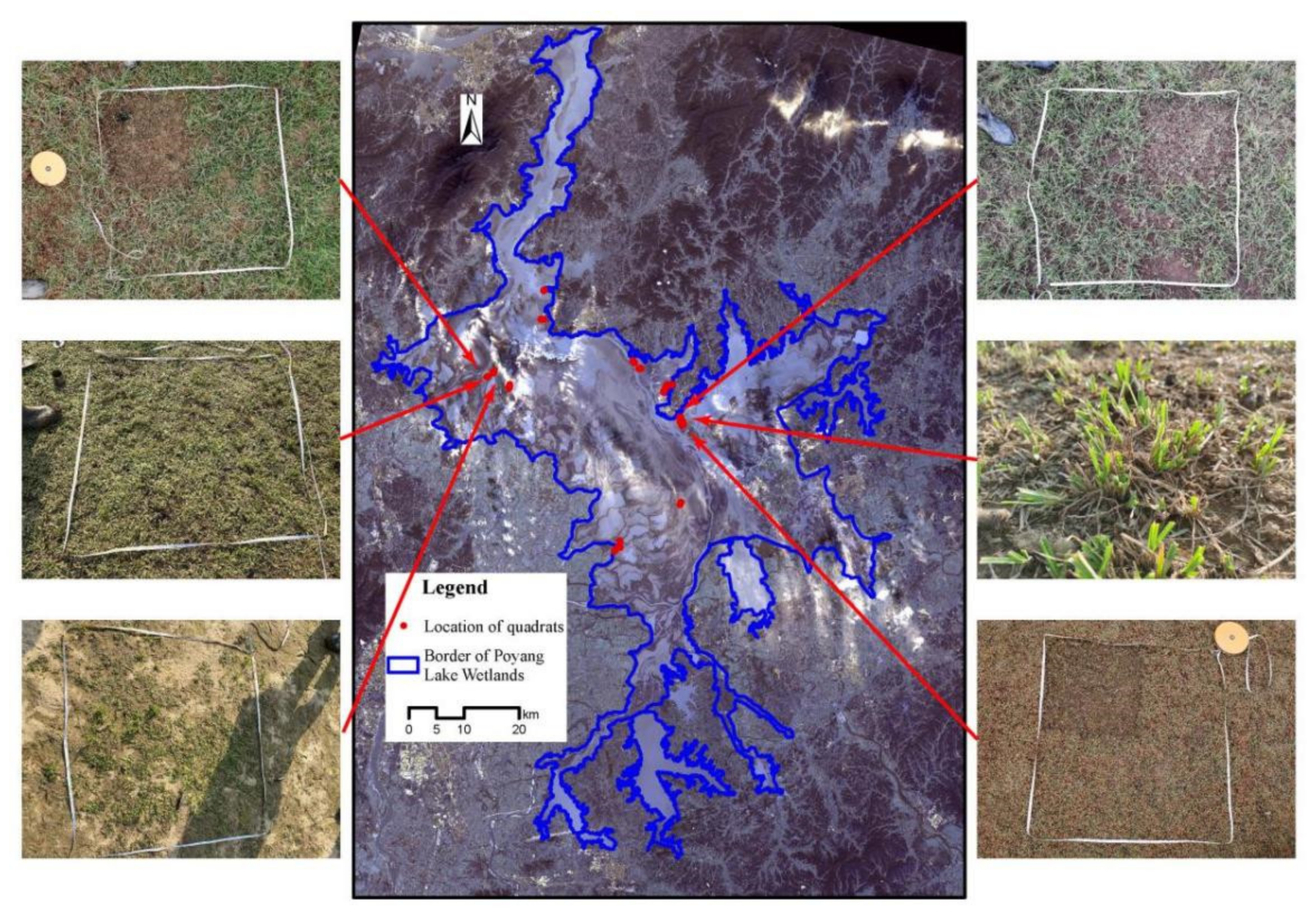
2.1. Study Area

Poyang Lake is located on the south bank of the middle and lower reaches of the Yangtze River. Its geographical location is 115°9′–116°46′ E and 28°11′–29°51′ N. It is a typical subtropical monsoon climate: the mean annual temperature is 17.6 °C and the average annual precipitation is 1528 mm [25]. The entire lake is 173 km long from north to south, spanning 74 km at its widest areas and just 2.8 km at its narrowest part [26]. Under the dual influence of five rivers—Ganjiang River, Fu River, Xin River, Rao River, and Xiu River—around Poyang Lake and the backwater effect of the Yangtze River, the annual and interannual water levels of Poyang Lake experience significant fluctuations [27]. These unique environmental conditions help to develop the species-rich wetland floras found in the Poyang Lake wetlands.

2.2. Field Investigation

The field investigation was conducted in the winter (December 2020 to January 2021), when Poyang Lake was in a low water-level period. A combination of transect and quadrat-based methods was used for sampling. A total of 12 transects were established along the littoral zones (elevation range of 10.5–12.5 m), where the variation in the plant community is obvious (Table S1). Along each transect, 10–15 quadrats were taken at about 100 m intervals depending on the length of each transect and vegetation zonation (Figure 1). A total of 150 quadrats that were 1 × 1 m in size were established. All of the species in each quadrat were recorded, and the coverage abundance and aboveground biomass for each species were measured [28]. The plant species coverage was estimated using a visual method. The abundance of each plant species was assessed using the Drude scale [28]. The aboveground biomass of each species was harvested and weighed in the field. Moreover, the locations of the quadrats were recorded using the global positioning system (GPS), and animal activities were recorded as well. The species were identified, and the nomenclature of the plant communities was standardized according to the Flora of China [29]. After the quadrats had been investigated, a soil sample (approximately 500 g) was collected from each quadrat at a depth of 0~10 cm from the topsoil using a five-spot-sampling method and mixed into one sample. The selected soil depth represented the amount deposited in the past 50 years, with an average sedimentation rate of 2.2 mm a−1 estimated using 137Cs and 210Pb methods [30]. All soil samples were put into polyethylene-sealed bags, and the compositions of their soil particles determined in our laboratory.

2.3. Environmental Data Collection

The soil samples were preprocessed before the particle composition was determined. Preprocessing included removing any impurities and foreign matter from the sample and air-drying in a cool place. Then, the processed samples were pretreated with the addition of 10% H2O2 and HCl to remove any organic matter or inorganic carbon matter. The soil particle composition for each soil sample was analyzed and determined using a laser diffraction particle size analyzer (LS 13320, Beckman, Brea, CA, USA), with a measuring range of 0–2000 μm. The proportions of sand (>50 μm), silt (2–50 μm), and clay (<2 μm) were divided and calculated according to the American soil texture classification system (USAD) [31].
Furthermore, we calculated eleven ecohydrological parameters for every quadrat based on a digital elevation model (DEM) of Poyang Lake. The spatial resolution of the DEM was 5 m, and the contour interval was 0.2 m. A difference value of DEM > 0 indicated that the quadrat was flooded, and the opposite result indicated that it was not flooded. We counted the annual flood duration from 2013 to 2020 based on the days with a value > 0. Additionally, the mean and longest annual flood durations over ten years and the mean annual flood durations of the last five years could be counted. The elevation of each quadrat was also extracted from the DEM.

2.4. Data Analysis

We categorized the life forms of plant species based on the Raunkiaer system [32] and determined the sediment-tolerant types for plants according to the ability of the plants to adapt to sedimentation [33]. To classify and identify the types of wetland plant communities in the littoral zones of Poyang Lake, we applied the agglomerative hierarchical cluster using Ward’s linkage method. The Jaccard index was then used to indicate the dissimilarity between quadrats for cluster analysis. The validity of the resulting clusters was improved by approximating natural clustering using the silhouette algorithm [34]. We assessed how the dissimilarity changed within and between the assigned classification clusters using a detrended correspondence analysis (DCA) [35]. The DCA parameters were the default settings: 4 ordination axes and 26 segments. The multi-response permutation procedure (MRPP) and the analysis of similarities (ANOSIM) with Bray–Curtis distance were implemented to test the distinguishability of the accepted classification results. The chi-square test was used to analyze the association between sediment types and plant community clusters.
Next, we used a cluster and principal component analysis of the grain-size compositions and average particle sizes to categorize the sediments into three types: lacustrine sediments (44 quadrats), fluvio-lacustrine sediments (81 quadrats), and fluvial sediments (25 quadrats) (Figure 2). Additionally, we applied the chi-square test to analyze the association between the sediment types and plant community clusters.
To explore the major environmental gradients determining the distribution of the plant communities, we used constrained ordination. The DCA results revealed that the gradient length of the first axis (2.31) was less than 3 SD (standard deviation units), indicating that redundancy analysis (RDA) could be used. The environmental factors included ecohydrological parameters, elevation, and the proportions of sand, silt, and clay. Forward selection was conducted to reduce the collinearity of the environmental variables.
We analyzed the effects of the sedimentary deposition types on the species diversity of plant communities. The species diversity metrics included species richness (SR) and the Shannon index (H) [36,37]. H is one of the most widely used measures of diversity and is based on information theory. H can be calculated as follows:
H = p i ln p i
where SR is the number of species, and p i is the relative abundance of a species in a quadrat, namely   p i = n i N for which n i is the abundance of a species in a quadrat and N is the summed abundance of all species in that quadrat.
Next, we used the non-parametric Kruskal–Wallis test to compare and analyze the differences in species diversity among the different plant communities and sediment types.
We conducted all of the data analyses and constructed the graphs using the R v4.1.0 platform [38]. The following R packages were used: vegan v2.5-7 [39], adiv v 2.1.1 [40], pgirmess v1.7.0 [41], and ggplot2 [42]. Vegan v2.6-2 was used to conduct the plant community classification and ordination; adiv v 2.1.1 was used to calculate the diversity indexes; pgirmess v1.7.0 was used for the multiple comparison tests; and ggplot2 was used to visualize the results.

3. Results

3.1. Species Compositions of Plant Communities in the Wetlands

According to the field investigation, sixteen plant species were recorded in the wetland plant communities and were found to belong to seven families (Table 1). Most of those species were from Polygonaceae, with the least species coming from Ranunculaceae and Rosaceae. Among those plants, both Carex cinerascens and Polygonum criopolitanum were the most common and widely distributed and thus the most dominant. In terms of life forms, there were six therophyte species, six cryptophyte species, one hemicryptophyte species, and three chamaephyte species. Moreover, most of the species showed a positive response and were able to adapt to the sedimentation.

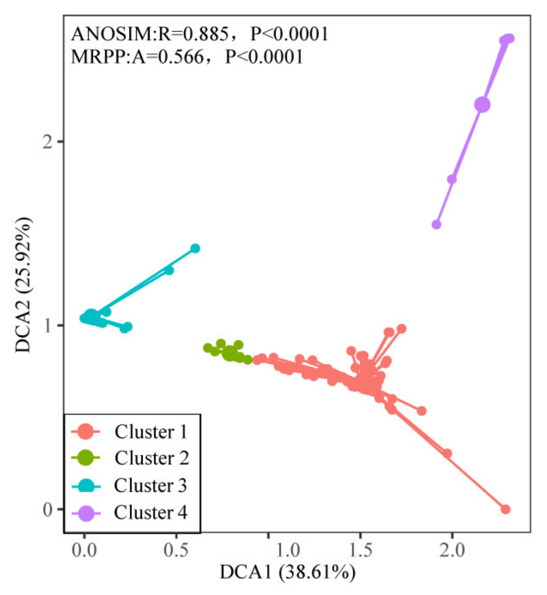
3.2. Quantitative Classification of Plant Communities

The phytosociological classification results showed that the average silhouette width was 0.73, and the 150 community quadrats were divided into four clusters (Figures S1 and S2). The first cluster was the Carex cinerascens community, with 74 quadrats and an average silhouette width of 0.60. The second cluster was the Carex cinerascens–Polygonum criopolitanum community, with 14 quadrats and an average silhouette width of 0.80; it was often located in the ecotone between the Polygonum criopolitanum communities and the Carex cinerascens communities. The third cluster was the Polygonum criopolitanum community, with 56 quadrats and an average silhouette width of 0.92. The fourth cluster was the Phalaris arundinacea community, with 6 quadrats and an average silhouette width of 0.56.
The analysis results of the quantitative classification were then ranked by DCA (Figure 3). The proportion of the variation in the first two axes was 64.53%, and the variation among the different community groups exceeded that within groups. The four community types were well distinguished by different ranking spaces (ANOSIM: R = 0.885, p < 0.0001; MRPP: A = 0.566, p < 0.0001). According to Figure 3, the quadrats of the Polygonum criopolitanum community were distributed on the left of the ordination plot, while those of the Phalaris arundinacea community were distributed on its upper right corner. These two communities had the highest average dissimilarity. The Carex cinerascens–Polygonum criopolitanum community was distributed between the Polygonum criopolitanum and Carex cinerascens communities on the ordination plot, indicating that it was a transitional group between those two communities.

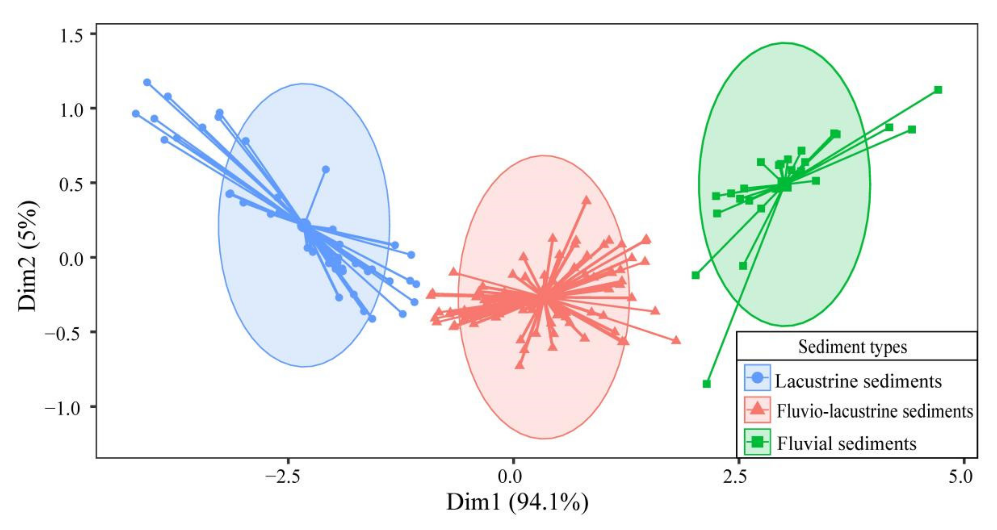
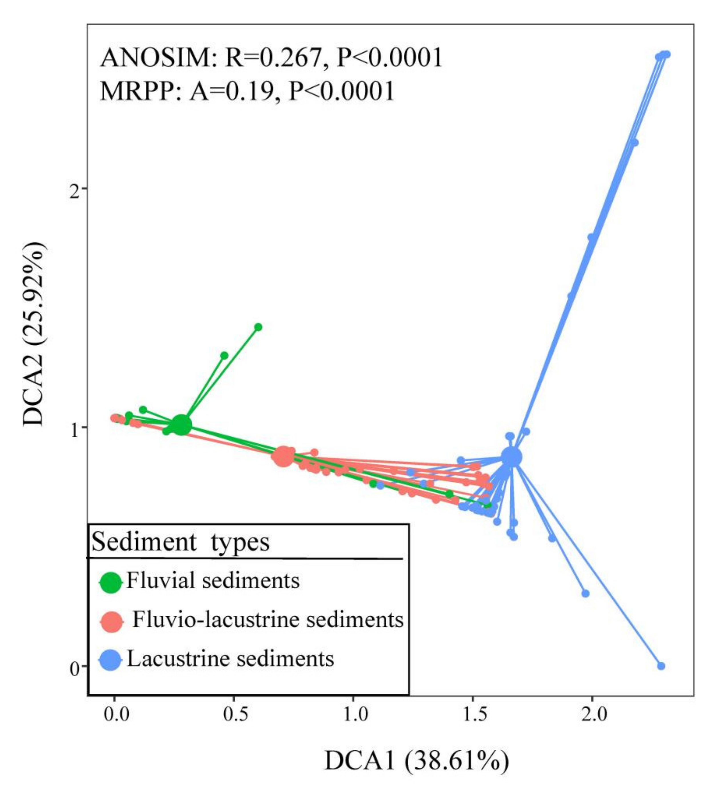
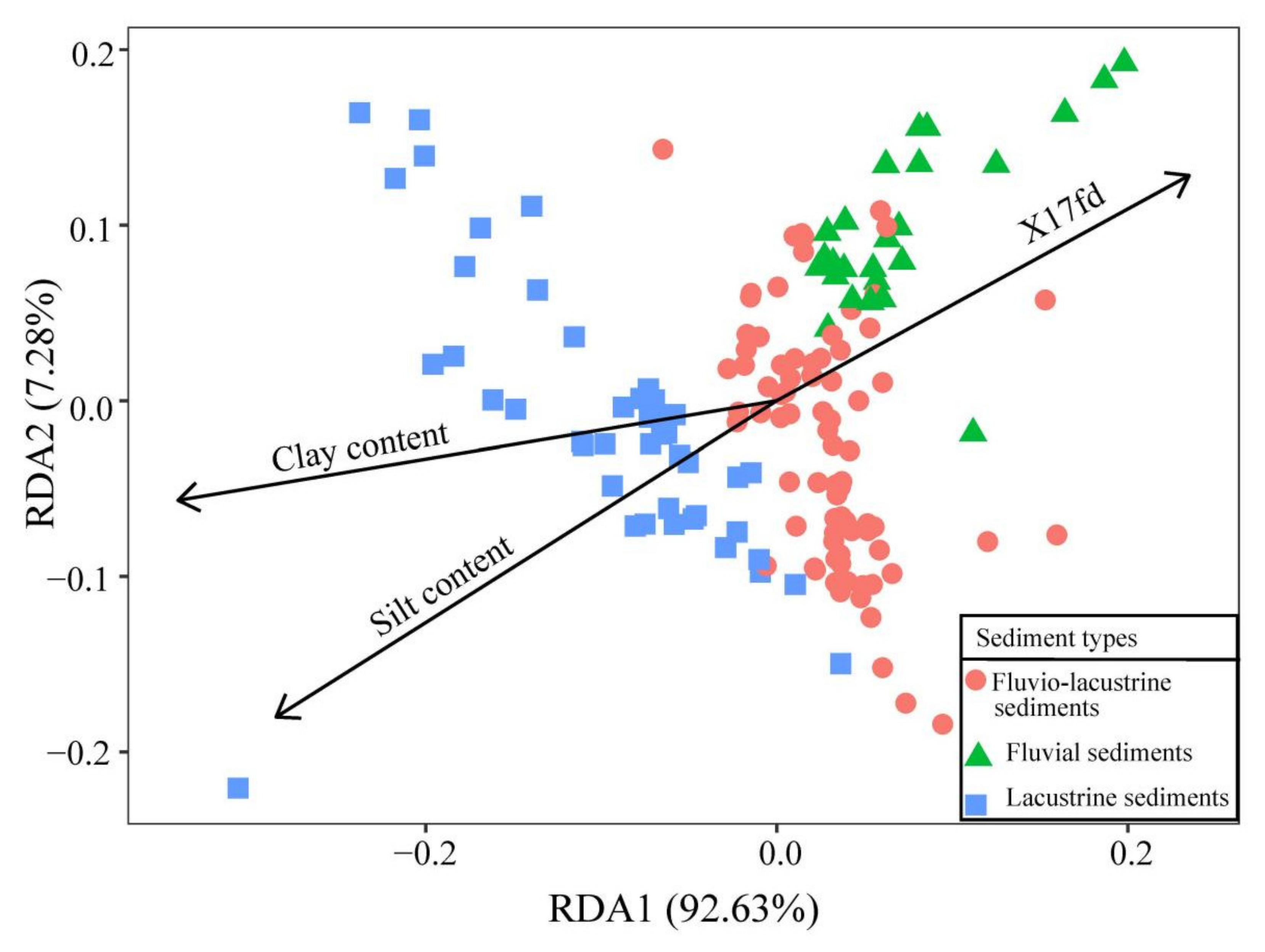
3.3. Sediment Types and Plant Community Distribution

The chi-square test was used to analyze the correlation between the sediment types and plant community types. These results revealed a significant correlation between sediment types and plant types in the quadrats (χ2 = 77.586, p < 0.0001).
In the fluvial sediments, the Polygonum criopolitanum community predominated, and a small portion of the Carex cinerascens community was present; apart from the Phalaris arundinacea community, the other communities were distributed in the fluvio-lacustrine sediments. Mostly Carex cinerascens and Phalaris arundinacea communities were distributed in the lacustrine sediments, with the latter being restricted to that sediment type in our surveyed plant community quadrats.
DCA was performed on the plant community quadrats according to the three sediment types (Figure 4). The results showed that the inter-group variation in the plant communities among the different sedimentary depositions was greater than their intra-group variation, leading to their pronounced separation in the DCA sorting space. On the ordination map, the plant communities of the lacustrine sediments were on the right side, while those of the fluvial sediments were on the left side. Accordingly, those of the fluvio-lacustrine sediments were located between the lacustrine sediments and fluvial sediments on the ordination map. The differences in the plant communities among the three sediment types were analyzed using ANOSIM and MRPP. The results of both tests (ANOSIM: R = 0.267, p < 0.0001; MRRP: A = 0.19, p < 0.0001) indicated that the plant communities changed significantly across the sediment types.
Before this ranking analysis, the environmental variables that had significant effects were selected by forward selection and included flood duration in 2017 (x17fd) (p < 0.05), silt content (p < 0.05), and clay content (p < 0.01). The total variance of the forward selection was 2300.1, and the constrained variance was 611.3. The three significant factors explained 26.58% of the variance. The total inertia of this RDA was 2300.1, its restricted inertia was 519.6, its unrestricted inertia was 1780.5, and the explanatory power of the environmental factors was 22.59% according to this ranking. Altogether, the first three RDA axes explained 100% of the variance in the data, but the first two axes accounted for 99.91%; hence, these first two axes in the sorting space could explain the vast majority of the variance present. As seen in the RDA two-dimensional ordination map (Figure 5) and the biplot scores for the constraining variables (Table 2), a strong correlation existed between the plant communities and the soil grain-size composition.

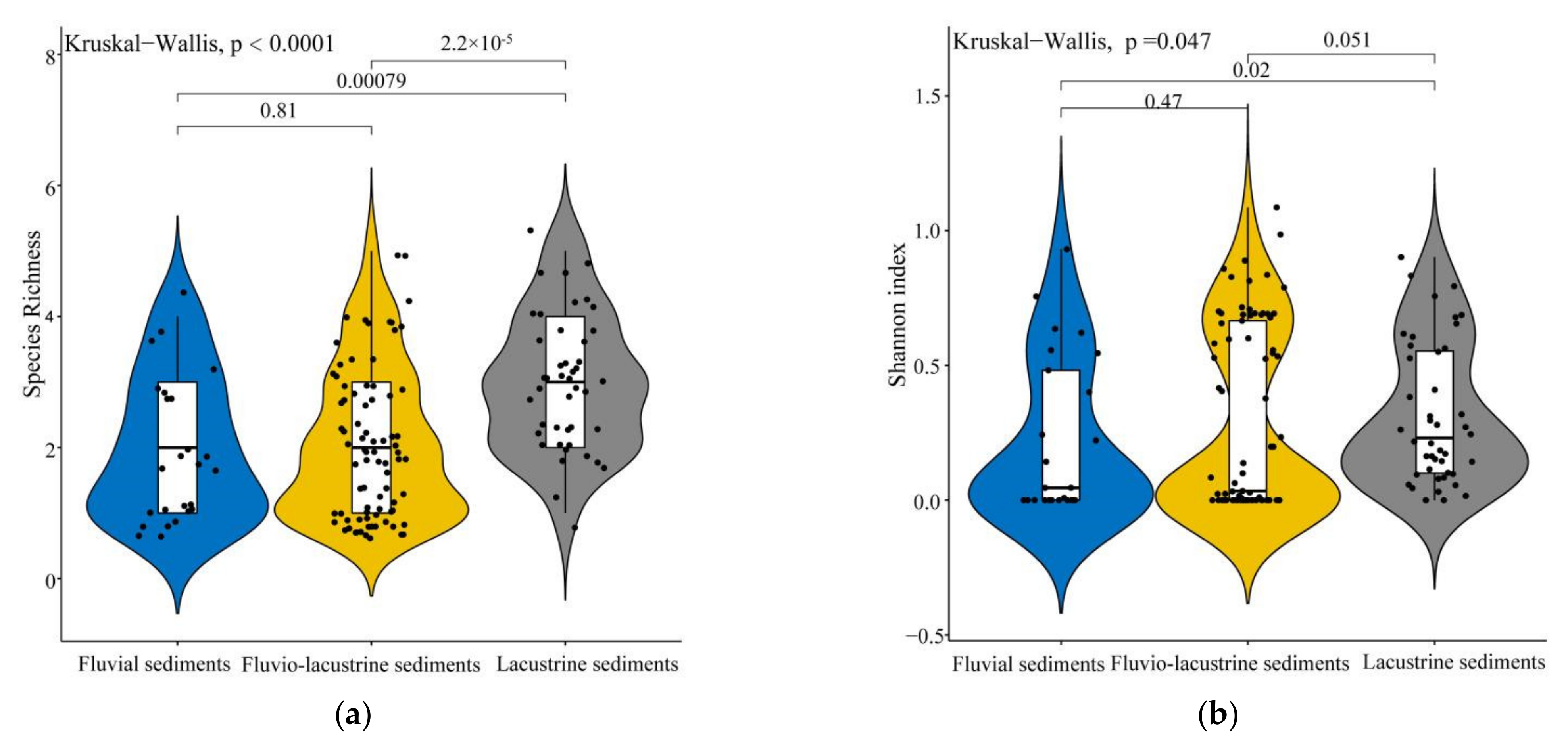
3.4. Comparison of Plant Species Diversity among Three Sediment Types

Kruskal–Wallis tests were used to compare the differences in the diversity of the plant communities among the three sediment types. Statistically significant differences among the SR and H of the three sediment types were observed (SR: p < 0.0001; H: p < 0.05). The two indexes were much greater for the lacustrine sediments than they were for either the fluvio-lacustrine sediments or the fluvial sediments (Figure 6a,b). However, no significant difference was observed in either of the two indexes between the fluvio-lacustrine and fluvial sediments (Figure 6a,b). In general, there might be a discernible gradient change in plant species diversity across the three sediment types. The species diversity level of the lacustrine sediments was significantly higher than that of the fluvio-lacustrine or fluvial sediments.

4. Discussion

4.1. The Distribution of Wetland Plants Differs among Sedimentary Deposition Types along the Beaches of Poyang Lake

In this study, 150 quadrats from the littoral zones of Poyang Lake were classified into three sediment types, namely lacustrine sediments, fluvio-lacustrine sediments, and fluvial sediments. Among these, the fluvio-lacustrine sediments accounted for the vast majority, which is consistent with the distribution of Poyang Lake’s sedimentary environment reported by Gan et al. (2019) [43]. The distribution of plants among the sediment types was not the same: from the fluvial sediments to the lacustrine sediments, wetland plant communities transition from those dominated by Carex cinerascens and Phalaris arundinacea to a Polygonum criopolitanum community. There is actually an inseparable correlation between the formation of different sediment types and the complex hydrological characteristics of the Poyang Lake area [19,44]. During the dry season, when the water falls into the trough of Poyang Lake, the slope between the upper and lower reaches increases [17]. This intensifies the hydrodynamic force in the lake area. Then, a host of small-size particles such as clay and silt are suspended and transported by water flow, whereas the larger and heavier sand becomes settled [45]. The sand is exposed when the water level drops, forming the fluvial sediments; however, in the areas where the hydrodynamic environment is mild, clay and silt can also be deposited such that lacustrine sediments are formed. Concerning the formation of fluvio-lacustrine sediments, these represent a transitional state between the fluvial and lacustrine sediments. This discrepancy in particle composition leads to a differentiation in the soil texture among sediment types, which in turn triggers changes in other physical properties of the substrate and forms a distinctive soil microenvironment [46,47]. These can profoundly impact the survival, growth, distribution, and evolution of wetland plants [48]. The clay and silt soil in the lacustrine sediments sustains a high nutrient content and moisture content [48]. Carex cinerascens and Phalaris arundinacea—with robust rhizomes—are better suited to the lacustrine sediments [49]. Polygonum criopolitanum, a therophyte species, characterizes low nutrient requirements [50]. The plant can adapt well to the fluvio-lacustrine and fluvial sediments. Additionally, most wetland vegetation is accustomed to distribution in predominantly wet soils [51] and Polygonum criopolitanum achieves growth dominance easily in the sandy soil of fluvial sediments. It is worth emphasizing that the formation of sediments requires time [52]. Flooding in the past can have a significant impact on the current physical and chemical characteristics of sediments [53]. Then, the sediments mediate hydrological changes to affect the wetland vegetation distribution patterns and species diversity. Our RDA results showed that the composition of sediment particles and flood duration in 2017 are indeed closely related to the differences in the distribution of plants among sediment types. However, in our RDA, the differentiation in the soil moisture contents and groundwater levels across sediment types that could impose irreplaceable effects on plant communities [54] were not considered, resulting in the slightly low explanatory power of environmental factors (22.59%). In addition, in this research, we did not conduct an in-depth analysis of the relationship between changes in the soil fertility across sedimentary types and the distribution of wetland plants, either. The responses of the wetland vegetation distribution to soil fertility and water conditions influenced by grain-size compositions across soil-deposition types merit discussion and analysis in future studies. Additionally, they could help to further explain the influence of sediment types on the distribution of wetland plant communities.

4.2. Species Diversity of Wetland Plant Communities Differs among Sediment Types in the Poyang Lake Wetlands

Because aspects of community diversity include the synthesis of the quantitative characteristics of different communities, they convey the differences among communities well [55]. The α, β, and γ indexes are commonly used to evaluate the species diversity of plant communities, and the α index can best reflect community-level changes in a local habitat [56]. Comparing the α diversity indexes of the community quadrats across the three sedimentary deposition types, the species diversity of the lacustrine sediments significantly surpassed those of the fluvial sediments and fluvio-lacustrine sediments. This shows that a predictable gradient might span the three types of soil deposition in different plant communities. Many of the Polygonum criopolitanum community quadrats were distributed in the fluvial sediments. Polygonum criopolitanum is a typical “c-strategy” plant that is able to grow rapidly and can make the most of the limited resources in the environment [50,57]. Over the course of its life, it relies on a strong asexual reproduction ability to form a large number of seedlings [29], resulting in a population growth advantage. Then, it will effectively occupy the living space of other wetland plants and replace them, which results in lower species diversity in fluvial sediments. Further, the compositions of soil particles also affect the diversity of plant communities [58]. Tiny particulate matter, such as clay and silt, is conducive to the formation of agglomerate structures in soil [59], thereby promoting the establishment and growth of plants [60,61]. From the lacustrine sediments to the fluvial sediments, the clay and silt contents decrease while the sand content increases. This enables lacustrine sediments to sustain a higher level of species diversity, whereas the fluvial sediments have a relatively low level of diversity. In addition, within the same elevation range, the sediment types are subject to varying degrees of hydrological disturbance. The greater the disturbance intensity, the lower the level of plant community diversity [62]. Fluvial sediments are generally more disturbed by hydrology than either lacustrine sediments or fluvio-lacustrine sediments. Therefore, in moving from lacustrine sediments to fluvial sediments, the diversity of wetland plant communities tends to decline.

5. Conclusions

The complex hydrological situation of Poyang Lake has led to the formation of the sediment types on its littoral zones which, coupled with its hydrological factors, have shaped the distribution patterns and diversity of the wetland plant communities there. Our results revealed that the three sediment types present in the Poyang Lake wetlands differ in their soil texture which, when combined with flood duration, influences the distribution of vegetation in the littoral zone. Additionally, the distribution of plant communities shifts from the Carex cinerascens and Phalaris arundinacea communities to the Polygonum criopolitanum community from the lacustrine sediments to the fluvial sediments. Furthermore, there is higher species diversity in the lacustrine sediments. Future research should investigate the relationship between wetland vegetation and soil deposition types. An analysis of the combined effects of sedimentary factors and hydrological factors can provide a conducive reference for the management and planning of Poyang Lake’s wetlands, as well as other freshwater wetlands, from a more scientific and comprehensive perspective.

Supplementary Materials

The following supporting information can be downloaded at: https://www.mdpi.com/article/10.3390/d14060491/s1, Figure S1: Silhouette width of plant groups; Figure S2: Cluster results of plant communities; Table S1: Information about the 12 sampled field transects.

Author Contributions

Conceptualization, G.G.; methodology, J.L. and Y.L. (Yizhen Liu); investigation, J.L., Y.L. (Yizhen Liu), Y.L. (Ying Liu), H.G., G.C. and Y.F.; data curation, J.L. and Y.L. (Yizhen Liu); writing—original draft preparation, J.L.; writing—review and editing, J.L., Y.L. (Yizhen Liu), Y.L. (Ying Liu), Z.F. and G.G.; visualization, J.L. and Y.L. (Yizhen Liu). All authors have read and agreed to the published version of the manuscript.

Funding

This research was funded by the National Natural Science Foundation of China (31860125) and the Youth Science Fund Project in Jiangxi Province (2018BA214004).

Institutional Review Board Statement

Not applicable.

Data Availability Statement

All data are available in this article.

Acknowledgments

We acknowledge technical assistance by Xiaoguo Xiang, Mingfei Wang, Kaifeng Xing, Qingshan Yang, and Yue Su. In addition, we would like to thank the anonymous reviewers for their helpful remarks.

Conflicts of Interest

The authors declare no conflict of interest.

References

  1. De Wilde, M.; Puijalon, S.; Bornette, G. Sediment type rules the response of aquatic plant communities to dewatering in wetlands. J. Veg. Sci. 2017, 28, 172–183. [Google Scholar] [CrossRef] [Green Version]
  2. Huai, W.X.; Li, S.L.; Katul, G.G.; Liu, M.Y.; Yang, Z.H. Flow dynamics and sediment transport in vegetated rivers: A review. J. Hydrodyn. 2021, 33, 400–420. [Google Scholar] [CrossRef]
  3. Yu, H.; Wang, L.; Liu, C.; Yu, D.; Qu, J. Effects of a spatially heterogeneous nutrient distribution on the growth of clonal wetland plants. BMC Ecol. 2020, 20, 59. [Google Scholar] [CrossRef] [PubMed]
  4. Wang, C.; Zheng, S.S.; Wang, P.F.; Hou, J. Interactions between vegetation, water flow and sediment transport: A review. J. Hydrodyn. 2015, 27, 24–37. [Google Scholar] [CrossRef]
  5. Zheng, P.R.; Li, C.H.; Ye, C.; Wang, H.; Wei, W.W.; Zheng, Y.; Zheng, X.Y. Characteristic and affecting factors of wetland herbs’ distribution in the radiant belt toward land of lake-terrestrial ecotone in Tibet, China. Environ. Sci. Eur. 2022, 34, 14. [Google Scholar] [CrossRef]
  6. Lo, E.; McGlue, M.; Silva, A.; Bergier, I.; Yeager, K.; Macedo, H.; Swallom, M.; Assine, M. Fluvio-lacustrine sedimentary processes and landforms on the distal Paraguay fluvial megafan (Brazil). Geomorphology 2019, 342, 163–175. [Google Scholar] [CrossRef]
  7. Fan, H.X.; Xu, L.G.; Wang, X.L.; Jiang, J.H.; Feng, W.J.; You, H.L. Relationship between vegetation community distribution patterns and environmental factors in typical wetlands of Poyang Lake, China. Wetlands 2019, 39, S75–S87. [Google Scholar] [CrossRef]
  8. Zheng, Z.; Ma, P.F. Changes in above and belowground traits of a rhizome clonal plant explain its predominance under nitrogen addition. Plant Soil 2018, 432, 415–424. [Google Scholar] [CrossRef]
  9. Guan, B.; Xie, B.H.; Yang, S.S.; Hou, A.X.; Chen, M.; Han, G.X. Effects of five years’ nitrogen deposition on soil properties and plant growth in a salinized reed wetland of the Yellow River Delta. Ecol. Eng. 2019, 136, 160–166. [Google Scholar] [CrossRef]
  10. Di Luca, G.A.; Maine, M.A.; Mufarrege, M.M.; Hadad, H.R.; Pedro, M.C.; Sanchez, G.C.; Caffaratti, S.E. Phosphorus distribution pattern in sediments of natural and constructed wetlands. Ecol. Eng. 2017, 108, 227–233. [Google Scholar] [CrossRef]
  11. Liu, Y.; Bachofen, C.; Lou, Y.J.; Ding, Z.; Jiang, M.; Lu, X.G.; Buchmann, N. The effect of temperature changes and K supply on the reproduction and growth of Bolboschoenus planiculmis. J. Plant Ecol. 2021, 14, 337–347. [Google Scholar] [CrossRef]
  12. Chen, X.S.; Li, X.; Xie, Y.H.; Li, F.; Hou, Z.Y.; Zeng, J. Combined influence of hydrological gradient and edaphic factors on the distribution of macrophyte communities in Dongting Lake wetlands, China. Wetl. Ecol. Manag. 2015, 23, 481–490. [Google Scholar] [CrossRef]
  13. Ren, G.H.; Deng, B.; Shang, Z.H.; Hou, Y.; Long, R.J. Plant communities and soil variations along a successional gradient in an alpine wetland on the Qinghai-Tibetan Plateau. Ecol. Eng. 2013, 61, 110–116. [Google Scholar] [CrossRef]
  14. Reza, S.K.; Nayak, D.C.; Chattopadhyay, T.; Mukhopadhyay, S.; Singh, S.K.; Srinivasan, R. Spatial distribution of soil physical properties of alluvial soils: A geostatistical approach. Arch. Agron. Soil Sci. 2016, 62, 972–981. [Google Scholar] [CrossRef]
  15. Chen, Y.P.; Xia, J.B.; Zhao, X.M.; Zhuge, Y.P. Soil moisture ecological characteristics of typical shrub and grass vegetation on Shell Island in the Yellow River Delta, China. Geoderma 2019, 348, 45–53. [Google Scholar] [CrossRef]
  16. Weiher, E.; Keddy, P.A. The Assembly of Experimental Wetland Plant Communities. Oikos 1995, 73, 323–335. [Google Scholar] [CrossRef]
  17. Gao, J.H.; Jia, J.; Kettner, A.J.; Xing, F.; Wang, Y.P.; Xu, X.N.; Yang, Y.; Zou, X.Q.; Gao, S.; Qi, S.; et al. Changes in water and sediment exchange between the Changjiang River and Poyang Lake under natural and anthropogenic conditions, China. Sci. Total Environ. 2014, 481, 542–553. [Google Scholar] [CrossRef]
  18. Ye, X.; Li, Y.; Li, X.; Zhang, Q. Factors influencing water level changes in China’s largest freshwater lake, Poyang Lake, in the past 50 years. Water Int. 2014, 39, 983–999. [Google Scholar] [CrossRef]
  19. Dai, Z.J.; Mei, X.F.; Darby, S.E.; Lou, Y.Y.; Li, W.H. Fluvial sediment transfer in the Changjiang (Yangtze) river-estuary depositional system. J. Hydrol. 2018, 566, 719–734. [Google Scholar] [CrossRef] [Green Version]
  20. Dai, X.; Wan, R.R.; Yang, G.S.; Wang, X.L.; Xu, L.G.; Li, Y.Y.; Li, B. Impact of seasonal water-level fluctuations on autumn vegetation in Poyang Lake wetland, China. Front. Earth Sci. 2019, 13, 398–409. [Google Scholar] [CrossRef]
  21. Hu, Z.; Ge, G.; Liu, C.; Chen, F.; Li, S. Structure of Poyang Lake wetland plants ecosystem and influence of lake water level for the structure. Resour. Environ. Yangtze Basin 2010, 19, 597–605. [Google Scholar]
  22. Fu, H.; Zhong, J.Y.; Yuan, G.X.; Guo, C.J.; Ding, H.J.; Feng, Q.; Fu, Q. A functional-trait approach reveals community diversity and assembly processes responses to flood disturbance in a subtropical wetland. Ecol. Res. 2015, 30, 57–66. [Google Scholar] [CrossRef]
  23. Qin, T.; Guan, Y.-T.; Zhang, M.-X.; Li, H.-L.; Yu, F.-H. Sediment type and nitrogen deposition affect the relationship between Alternanthera philoxeroides and experimental wetland plant communities. Mar. Freshw. Res. 2018, 69, 811. [Google Scholar] [CrossRef]
  24. Zhang, Y.; Chen, L.-B.; Qu, X.-D.; Kong, W.-J.; Meng, W. Environmental Factors and Community Characteristics of Aquatic Macrophytes in Taizi River Tributaries of Liaoning Province. Plant Sci. J. 2011, 29, 552–560. [Google Scholar] [CrossRef]
  25. Feng, W.J.; Mariotte, P.; Xu, L.G.; Buttler, A.; Bragazza, L.; Jiang, J.H.; Santonja, M. Seasonal variability of groundwater level effects on the growth of Carex cinerascens in lake wetlands. Ecol. Evol. 2020, 10, 517–526. [Google Scholar] [CrossRef] [Green Version]
  26. Zhang, Q.; Ye, X.C.; Werner, A.D.; Li, Y.L.; Yao, J.; Li, X.H.; Xu, C.Y. An investigation of enhanced recessions in Poyang Lake: Comparison of Yangtze River and local catchment impacts. J. Hydrol. 2014, 517, 425–434. [Google Scholar] [CrossRef] [Green Version]
  27. Dai, X.; Wan, R.R.; Yang, G.S. Non-stationary water-level fluctuation in China’s Poyang Lake and its interactions with Yangtze River. J. Geogr. Sci. 2015, 25, 274–288. [Google Scholar] [CrossRef] [Green Version]
  28. Fang, J.; Wang, X.; Shen, Z.; Tang, Z.; He, J.; Yu, D.; Jiang, Y.; Wang, Z.; Zheng, C.; Zhu, J.; et al. Methods and protocols for plant community inventory. Biodivers. Sci. 2009, 17, 533–548. [Google Scholar] [CrossRef]
  29. Flora of China. Available online: http://www.iplant.cn/foc/ (accessed on 5 March 2021).
  30. Ye, C. Contrasting Investigation by 137Cs Method and 210Pb Method for the Present Sedimentation Rate of Poyang Lake, Jiangxi. Acta Sedimentol. Sin. 1991, 9, 106. [Google Scholar]
  31. Barman, U.; Choudhury, R.D. Soil texture classification using multi class support vector machine. Inf. Process. Agric. 2020, 7, 318–332. [Google Scholar] [CrossRef]
  32. Di Biase, L.; Pace, L.; Mantoni, C.; Fattorini, S. Variations in Plant Richness, Biogeographical Composition, and Life Forms along an Elevational Gradient in a Mediterranean Mountain. Plants 2021, 10, 2090. [Google Scholar] [CrossRef] [PubMed]
  33. Pan, Y.; Xie, Y.-H.; Chen, X.-S.; Li, F. Adaptation of wetland plants to sedimentation stress: A review. Shengtaixue Zazhi 2011, 30, 155–161. [Google Scholar]
  34. Murtagh, F.; Legendre, P. Ward’s Hierarchical Agglomerative Clustering Method: Which Algorithms Implement Ward’s Criterion? J. Classif. 2014, 31, 274–295. [Google Scholar] [CrossRef] [Green Version]
  35. Hill, M.O.; Gauch, H.G. Detrended Correspondence Analysis: An Improved Ordination Technique. Vegetatio 1980, 42, 47–58. [Google Scholar] [CrossRef]
  36. Shaltout, K.H.; Eid, E.M.; Al-Sodany, Y.M.; Heneidy, S.Z.; Shaltout, S.K.; El-Masry, S.A. Effect of Protection of Mountainous Vegetation against Over-Grazing and Over-Cutting in South Sinai, Egypt. Diversity 2021, 13, 113. [Google Scholar] [CrossRef]
  37. Han, W.J.; Cao, J.Y.; Liu, J.L.; Jiang, J.; Ni, J. Impacts of nitrogen deposition on terrestrial plant diversity: A meta-analysis in China. J. Plant Ecol. 2019, 12, 1025–1033. [Google Scholar] [CrossRef]
  38. R Core Team. R: A Language and Environment for Statistical Computing; R Foundation for Statistical Computing: Vienna, Austria, 2012; Available online: https://www.R-project.org/ (accessed on 8 April 2021).
  39. Oksanen, J. Vegan Community Ecology Package Version 2.6-2. 2021. Available online: https://CRAN.R-project.org/package=vegan (accessed on 8 April 2021).
  40. Pavoine, S. Adiv: Analysis of Diversity. R Package Version 2.1.1. 2021. Available online: https://CRAN.R-project.org/package=adiv (accessed on 20 April 2021).
  41. Giraudoux, P.; Antonietti, J.P.; Beale, C.; Lancelot, R.; Pleydell, D.; Treglia, M. Pgirmess: Spatial Analysis and Data Mining for Field Ecologists. R Package Version 1.7.0. 2021. Available online: https://CRAN.R-project.org-/package=pgirmess (accessed on 22 April 2021).
  42. Wickham, H. Ggplot2: Elegant Graphics for Data Analysis, 2nd ed.; Springer International Publishing AG: Houston, TX, USA, 2016. [Google Scholar]
  43. Gan, J.; Wan, S.; Li, J.; Tang, C.; Yang, T.; Luozang, Q. Classification of lacustrine soft soil based on sedimentary environment and engineering characteristics—A case study of four typical soft soil in Poyang Lake basin. Geol. Rev. 2019, 65, 983–992. [Google Scholar] [CrossRef]
  44. Bracken, L.J.; Turnbull, L.; Wainwright, J.; Bogaart, P. Sediment connectivity: A framework for understanding sediment transfer at multiple scales. Earth Surf. Processes Landf. 2015, 40, 177–188. [Google Scholar] [CrossRef] [Green Version]
  45. Selim, T.; Hesham, M.; Elkiki, M. Effect of sediment transport on flow characteristics in non-prismatic compound channels. Ain Shams Eng. J. 2022, 13, 101771. [Google Scholar] [CrossRef]
  46. Juma, N.G. Interrelationships between soil structure/texture, soil biota/soil organic matter and crop production. Geoderma 1993, 57, 3–30. [Google Scholar] [CrossRef]
  47. Smaill, S.J.; Clinton, P.W.; Allen, R.B.; Leckie, A.C.; Davis, M.R. Coarse soil can enhance the availability of nutrients from fine soil. J. Plant Nutr. Soil Sci. 2014, 177, 848–850. [Google Scholar] [CrossRef]
  48. Mobilian, C.; Craft, C.B. Wetland Soils: Physical and Chemical Properties and Biogeochemical Processes. Ref. Modul. Earth Syst. Environ. Sci. 2021, 3, 157–168. [Google Scholar] [CrossRef]
  49. Ren, B. Analysis on the Typical Phytocoenoses and Its Principle Factors of Distribution Paterns in East Dongting Lake Wetland. Ph.D. Thesis, Hunan Agricultural University, Changsha, China, 2012. [Google Scholar]
  50. Zhou, D.M.; Luan, Z.Q.; Guo, X.Y.; Lou, Y.J. Spatial distribution patterns of wetland plants in relation to environmental gradient in the Honghe National Nature Reserve, Northeast China. J. Geogr. Sci. 2012, 22, 57–70. [Google Scholar] [CrossRef]
  51. Ballantine, K.; Schneider, R.; Groffman, P.; Lehmann, J. Soil Properties and Vegetative Development in Four Restored Freshwater Depressional Wetlands. Soil Sci. Soc. Am. J. 2012, 76, 1482. [Google Scholar] [CrossRef] [Green Version]
  52. Nyarko, B.K. Wetland river flow interaction in a sedimentary formation of the white Volta basin, Ghana. Earth Sci. Res. 2019, 9, 15–30. [Google Scholar] [CrossRef] [Green Version]
  53. Feng, W.J.; Santonja, M.; Bragazza, L.; Buttler, A. Shift in plant-soil interactions along a lakeshore hydrological gradient. Sci. Total Environ. 2020, 742, 140254. [Google Scholar] [CrossRef]
  54. Castelli, R.M.; Chambers, J.C.; Tausch, R.J. Soil-plant relations along a soil-water gradient in great basin riparian meadows. Wetlands 2000, 20, 251–266. [Google Scholar] [CrossRef]
  55. Mougi, A.; Kondoh, M. Diversity of Interaction Types and Ecological Community Stability. Science 2012, 337, 349–351. [Google Scholar] [CrossRef]
  56. Ram, J.; Singh, J.S.; Singh, S.P. Plant biomass, species diversity and net primary production in a central Himalayan high altitude grassland. J. Ecol. 1989, 77, 456–468. [Google Scholar] [CrossRef]
  57. Grime, J.P. Evidence for the Existence of Three Primary Strategies in Plants and Its Relevance to Ecological and Evolutionary Theory. Am. Nat. 1977, 111, 1169–1194. [Google Scholar] [CrossRef]
  58. Rodrigues, P.M.S.; Schaefer, C.E.G.R.; de Oliveira Silva, J.; Ferreira Júnior, W.G.; dos Santos, R.M.; Neri, A.V. The influence of soil on vegetation structure and plant diversity in different tropical savannic and forest habitats. J. Plant Ecol. 2018, 11, 226–236. [Google Scholar] [CrossRef]
  59. Papadopoulos, A. Soil Aggregates, Structure, and Stability. In Encyclopedia of Agrophysics; Gliński, J., Horabik, J., Lipiec, J., Eds.; Springer: Dordrecht, the Netherlands, 2011; pp. 736–740. [Google Scholar]
  60. Stirzaker, R.J.; Passioura, J.B.; Wilms, Y. Soil structure and plant growth: Impact of bulk density and biopores. Plant Soil 1996, 185, 151–162. [Google Scholar] [CrossRef]
  61. Li, Y.; Wang, D.; Xin, Z. Spatial distribution of vegetation and soil in aquatic-terrestrial ecotone, Li River. Trans. Chin. Soc. Agric. Eng. 2013, 29, 121–128. [Google Scholar] [CrossRef]
  62. Limberger, R.; Wickham, S.A. Disturbance and diversity at two spatial scales. Oecologia 2012, 168, 785–795. [Google Scholar] [CrossRef] [PubMed] [Green Version]
Figure 1. Locations of quadrats in our survey.
Diversity 14 00491 g001
Figure 2. Sediment types were assigned using cluster and principal component analysis.
Diversity 14 00491 g002
Figure 3. DCA of the plant communities on the quadrats. Cluster 1: Carex cinerascens community; Cluster 2: Carex cinerascens–Polygonum criopolitanum community; Cluster 3: Polygonum criopolitanum community; Cluster 4: Phalaris arundinacea community.
Diversity 14 00491 g003
Figure 4. DCA of plant communities in three sediment types.
Diversity 14 00491 g004
Figure 5. RDA of plant communities on three sediment types. X17fd indicates flood duration in 2017.
Diversity 14 00491 g005
Figure 6. Alpha diversity (two metrics) of the plant communities was compared among the three soil deposition types: (a) species richness (SR); (b) Shannon index (H).
Diversity 14 00491 g006
Table 1. Sample survey of wetland plant species.
S/NSpeciesFamilyLife FormSediment-Tolerant Types
1Cardamine lyrataBrassicaceaeCryptophyteSediment-dependence
2Cardamine impatiensBrassicaceaeTherophyteSediment-dependence
3Heleocharis valleculosaCyperaceaeCryptophyteSediment-dependence
4Carex cinerascensCyperaceaeCryptophyteSediment-tolerance
5Phalaris arundinaceaGramineaeCryptophyteSediment-tolerance
6Potentilla limprichtiiRosaceaeChamaephyteSediment-tolerance
7Polygonum pubescensPolygonacaeTherophyteSediment-tolerance
8Polygonum criopolitanumPolygonacaeTherophyteSediment-tolerance
9Rumex acetosaPolygonacaeChamaephyteSediment-tolerance
10Rumex acetosellaPolygonacaeChamaephyteSediment-tolerance
11Artemisia selengensisAsteraceaeCryptophyteSediment-dependence
12Lapsana apogonoidesAsteraceaeTherophyteSediment-sensitivity
13Gnaphalium affineAsteraceaeTherophyteSediment-sensitivity
14Hemarthria altissimaGramineaeHemicryptophytaSediment-sensitivity
15Kalimeris indicaAsteraceaeCryptophyteSediment-dependence
16Ranunculus poliiRanunculaceaeTherophyteSediment-dependence
Table 2. The biplot scores for the constraining variables in RDA.
RDA AxesRDA1RDA2RDA3
Silt content−0.71−0.450.53
Clay content−0.85−0.140.50
X17fd0.580.320.74
Publisher’s Note: MDPI stays neutral with regard to jurisdictional claims in published maps and institutional affiliations.

