


Quantifying the Evolution of Giant Panda Habitats in Sichuan Province under Different Scenarios

Abstract
:1. Introduction
2. Materials and Methods
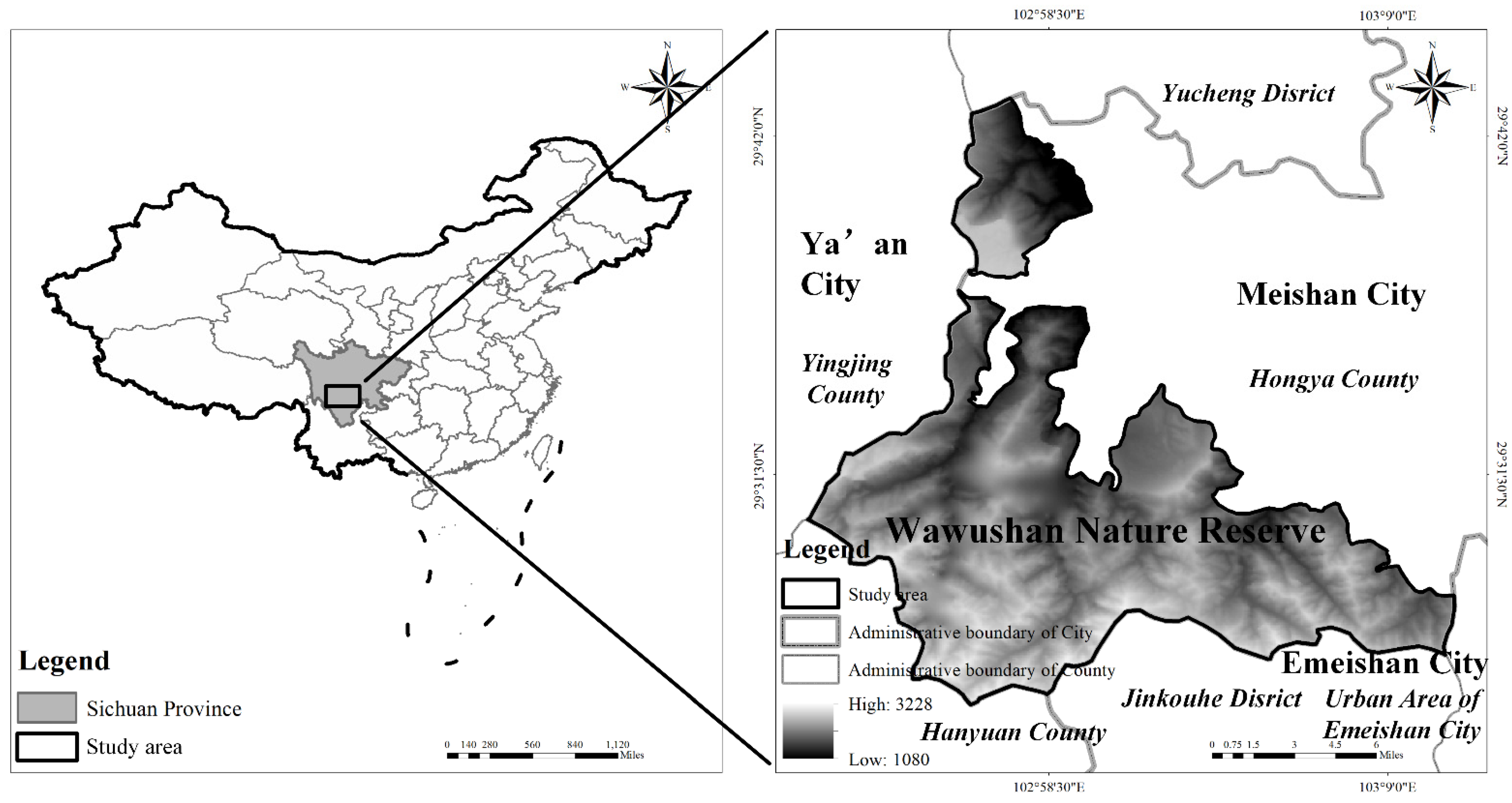
2.1. Study Area
2.2. Data Source and Pre-Processing
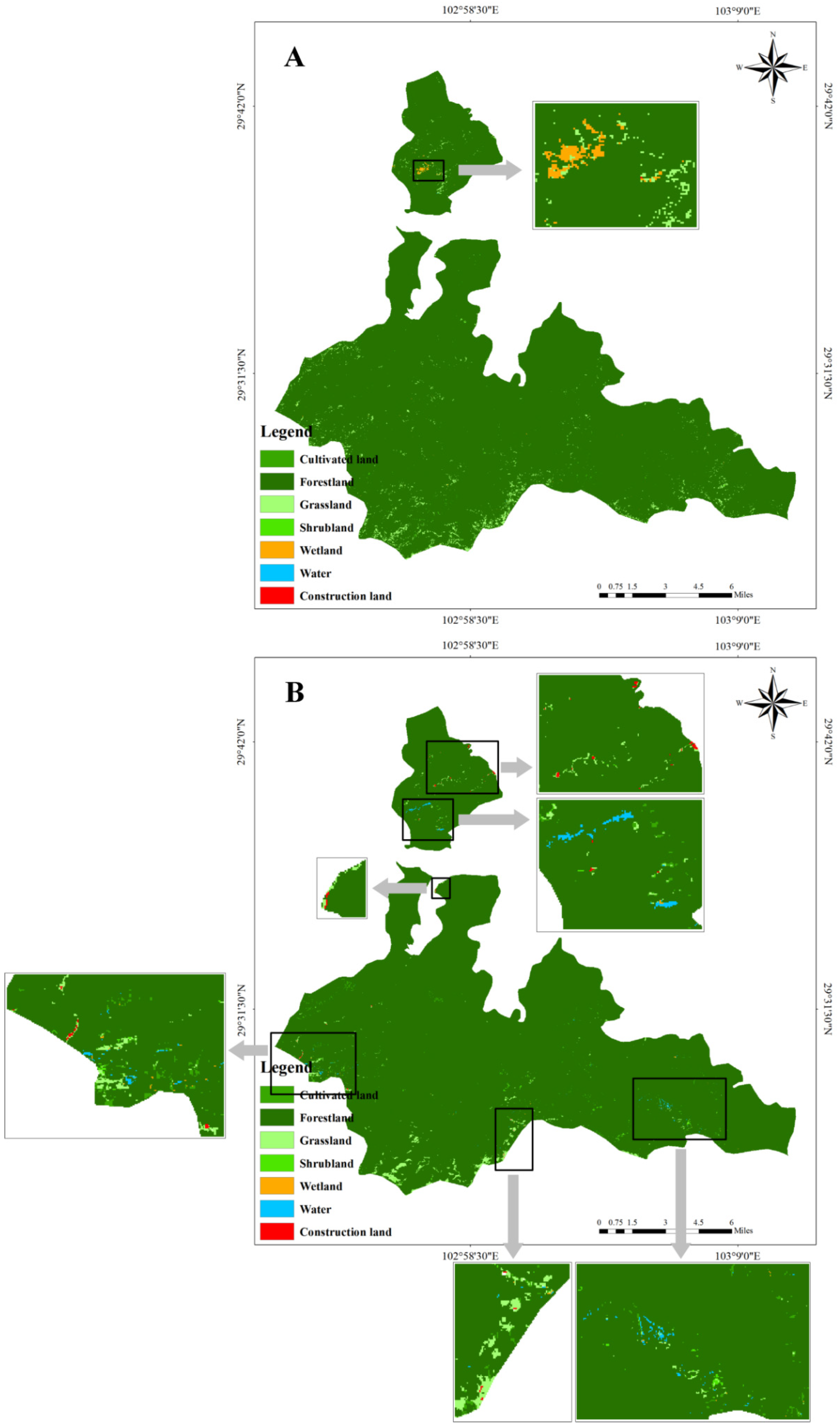
2.2.1. Landscape Pattern Classification
2.2.2. Driving Factors
2.3. Method
2.3.1. CA-Markov Model
- 1.
- The Markov Model is widely used in the research of random motion processes [46]. It determines the trend of landscape pattern change over time by measuring the initial probability of different states and the transition probability relationship between states to achieve landscape pattern change prediction [47]. The change of landscape type is usually anisotropic, that is, the land type can change from the current type to other types, or from other types to the current type. During the transition process, the types and number of giant panda are constantly changing. The key problem that the Markov Model solves is to determine the transition probability among different landscapes in complex landscape pattern change. The essence of landscape pattern change is that each transition probability constitutes a transition probability matrix:where, Pij represents the transition probability of landscape type I to landscape type J, and Pij should meet two conditions: 0 ≤ Pij ≤ 1 and . N is the number of landscape types [47].
- 2.
- Cellular automata (CA) is a discontinuous space-time dynamic model characterized by discrete time, space, and state [47,48,49,50]. The CA system consists of the cellular element and its state, cellular space, cellular neighborhood, and transformation rules. Each cell in cellular space has a finite number of specific states, updated synchronously according to multi-defined partial rules. These partial rules interact with each other to form a dynamic evolutionary system. The general expression of CA is:where C is finite and has a discrete set of states of cellular. t and t + 1 are different moments. N is the neighborhood of cellular. f is the cellular transformation rule of local space [47].C(t+1) = f(C(t),N)
- 3.
- The CA-Markov Model is supported by the GIS platform that determines the transition of the cellular state by the transforming area matrix and conditional probability image operations to simulate the change of landscape pattern [47,51]. The specific operation process is as follows:
- Superposition analysis: By superposition analysis, landscape type transition probability matrix, transition area matrix, and a series of conditional probability images are obtained. These images come from the transition probability matrix, representing the probability that each pixel will be covered by a landscape type at the next moment.
- Construct CA filter: According to the distance between neighbor and cell, the weight factor with significant spatial significance is created to make it act on the cell, so as to determine the state change of the cell. In this study, a 5 × 5 filter was used; that is, a rectangular space consisting of 5 × 5 cells around a cell was considered to have a significant influence on the change of the cell state.
- Determine the start time and the number of CA cycles: Based on the landscape type transition matrix of the study area from 2000 to 2017, the year 2017 was taken as the starting point for landscape pattern prediction, and the iteration number of the CA model was eight. The landscape pattern of the Giant Panda Nature Reserve and its external buffer zone in 2025 was simulated under the natural growth scenario.
2.3.2. Logistic Regression
2.3.3. Giant Panda Habitat Change Scenario Setting
- Scenario 1: Ecological priority (with the highest degree of feminizing and aging of the peasant labor force)
- Scenario 2: Coordinated development (with feminization and aging of the rural labor force slowing)
- Scenario 3: Partial constraint (with a high degree of feminizing and aging of the labor force)
- Scenario 4: Current situation (with a high degree of feminizing and aging of the labor force)
3. Results and Analysis
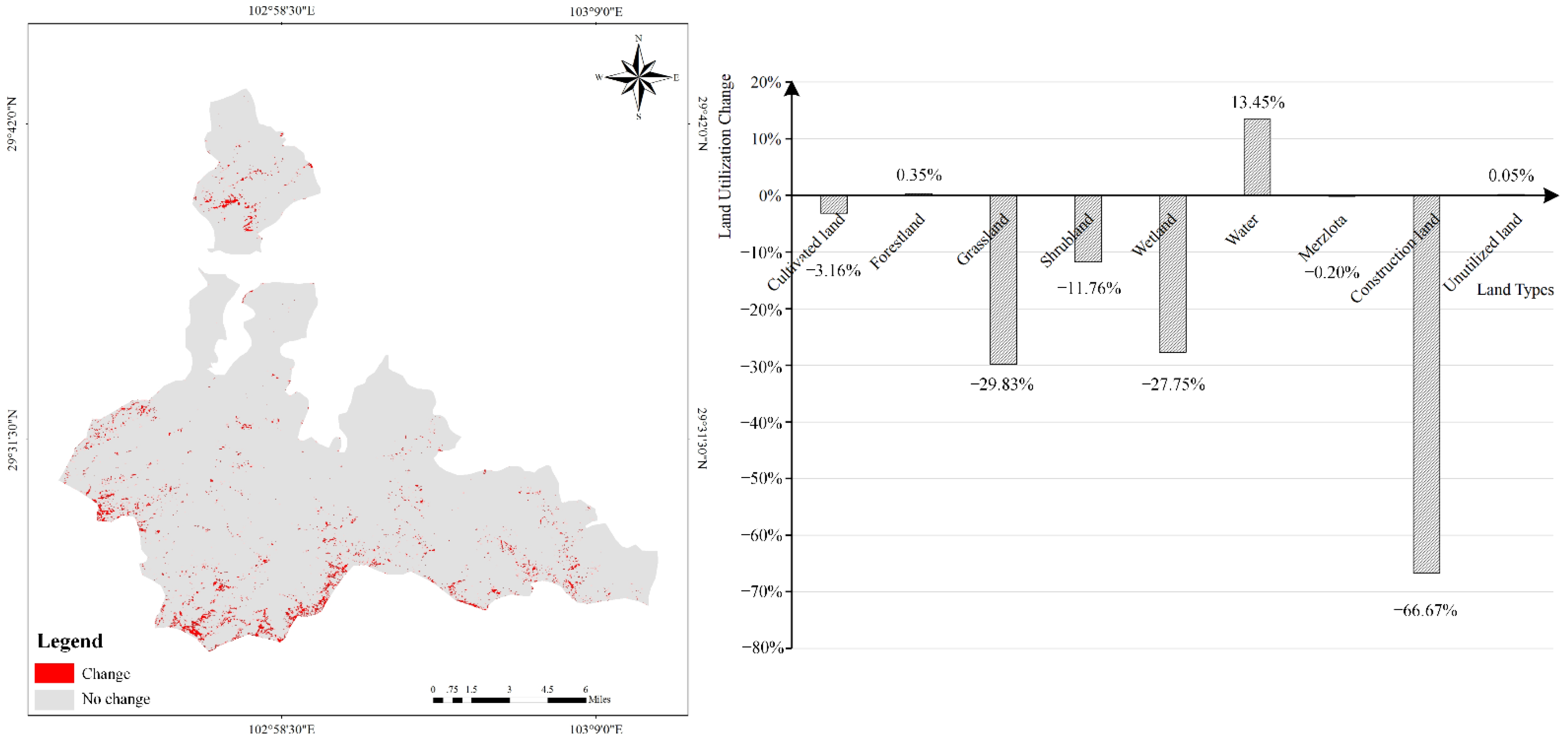
3.1. Temporal and Spatial Changes of Landscape Pattern
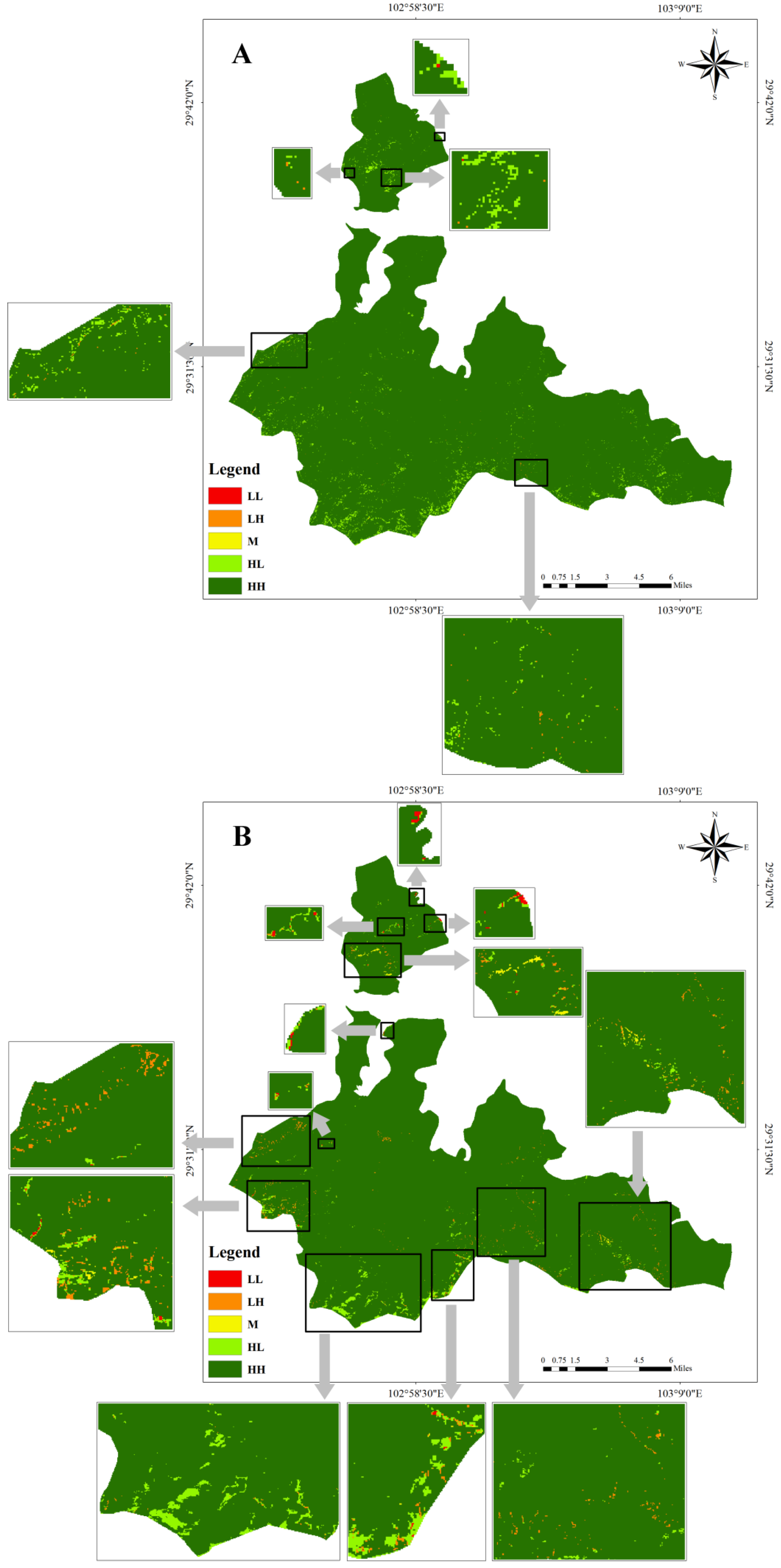
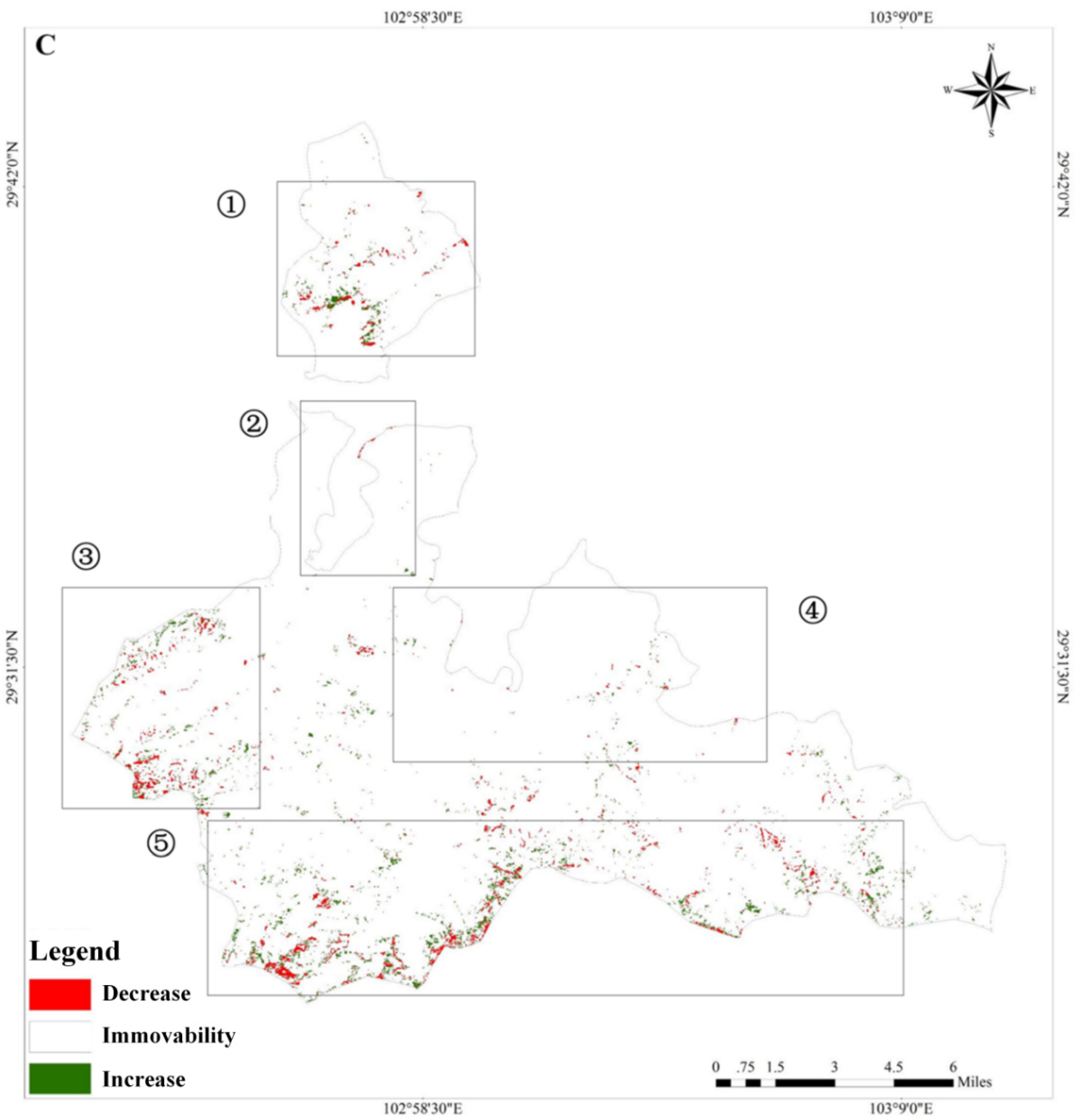
3.2. Habitat Quality Change


3.3. Analysis of Driving Forces in Landscape Pattern Evolution
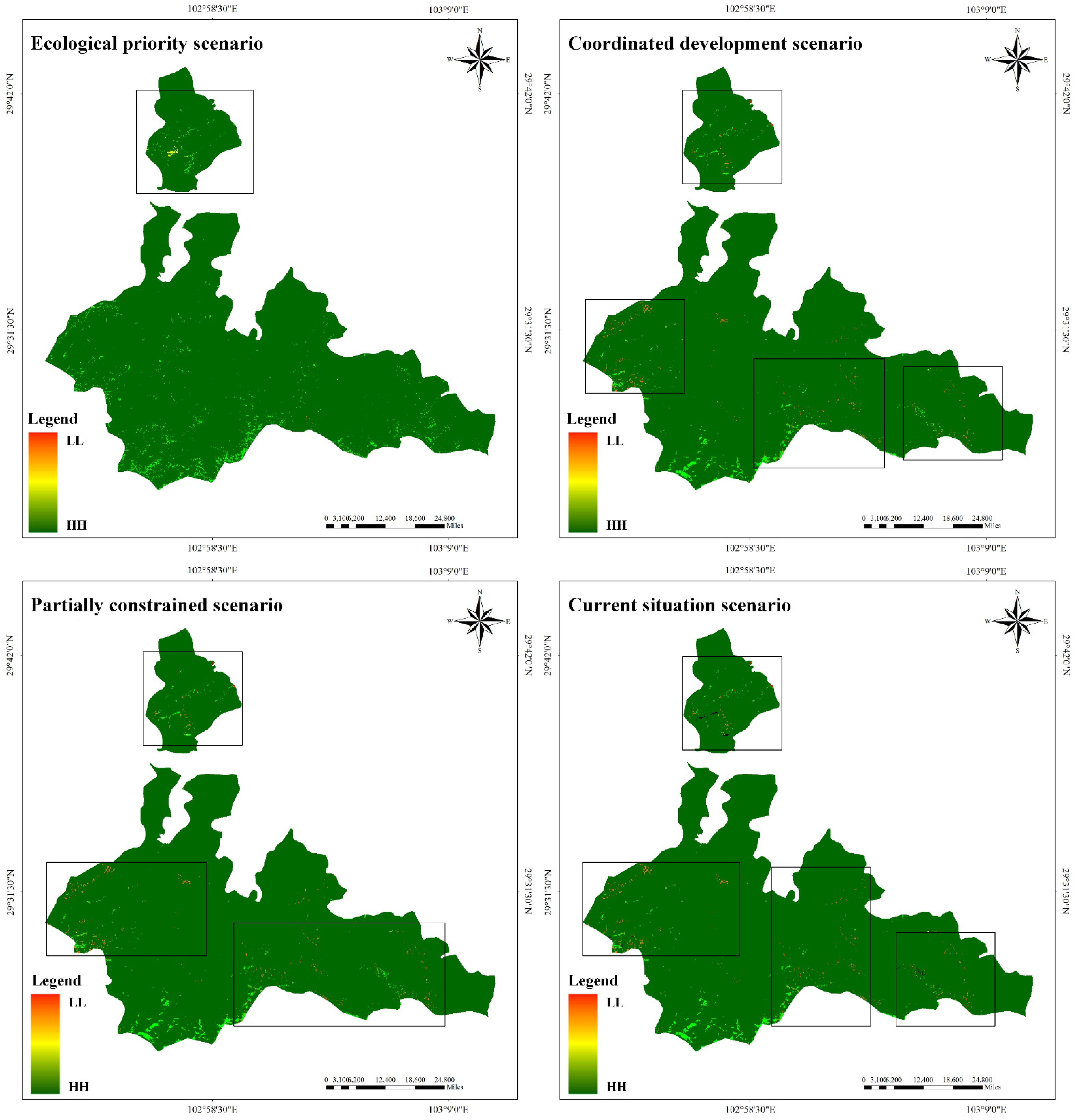
3.4. Prediction of Landscape Ecological Patterns
3.5. Habitat Quality Simulation
3.6. Effects of Farmers’ Preference for Resource Use on Habitat Evolution of Giant Pandas Habitat
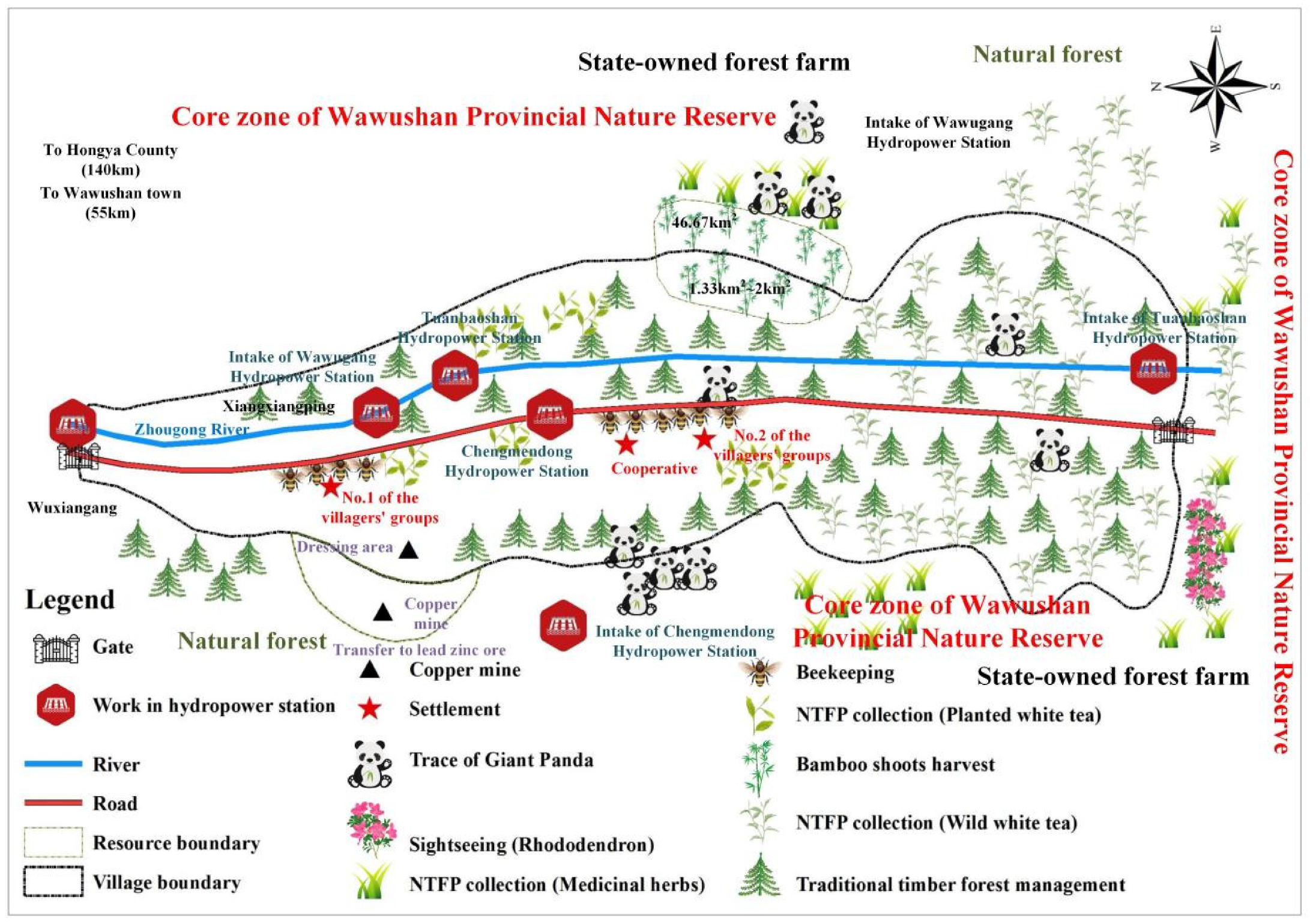
3.6.1. Forestry Resource-Dependent Communities: A Case Study of Changhe Village
- Community Profile
- 2.
- Resource Use Conflict: History and Present Situation
- 3.
- Farmers’ Coping Strategies and their Resource Utilization under Different Regulatory Intensities
- 4.
- Habitat Evolution of Giant Pandas under Different Control Intensification
- Scenario 1: Ecological priority. Under the ecological priority scenario, migration of the whole village can stop the impact of farmers’ resource utilization behavior on giant panda habitats. After a certain period of natural restoration, the land disturbed by humans can be naturally returned to woodland, shrubby, and other high-quality land. In this way, the local habitat quality can be significantly improved, and the simulation results of ecological priority scenarios in the previous paper can be verified.
- Scenario 2: Coordinated development. In the coordinated development scenario, farmers support electricity and food consumption with income from ecotourism operations. In this way, fuelwood and arable land use are reduced, and the contradiction between protection and development is small. The change intensity of resource use behavior is weaker than that of the partial constraint scenario. Consequently, the forest cover in the affected areas will be restored and vegetation indices will increase. The simulation results of the coordinated development scenario above are verified.
- Scenario 3: Partial constraint. In the partial constraint scenario, the resource utilization behavior of farmers is strongly constrained by the system. Farmers are willing to pay for free electricity in exchange for the development of ecological products that women and older workers can accomplish. Improvements in livelihoods are expected to compensate for the shortfall in food and energy consumption. In this way, the negative impact of institutional and labor structure changes on the livelihood of farmers is lessened, and the disturbance to the habitat of giant pandas is reduced. Therefore, the habitat landscape pattern of the affected Giant Panda Nature Reserve should be smoothly transformed into high quality. The simulation results of some constraint scenarios mentioned above are verified.
- Scenario 4: Current situation. In the present situation, farmers hope to selectively cut commercial forests. However, this conflicts with the existing system, meaning that the adverse selection behavior of farmers cannot be avoided. Under the background of feminizing and aging of the peasant labor force, the habitat quality of the regionally influenced Giant Panda Nature Reserve will change significantly in the next few years. The lack of institutional coordination will result in an overall decline in habitat levels (verified in Figure 5), which confirms changes in the habitat quality of giant pandas in the future, under the current situation.
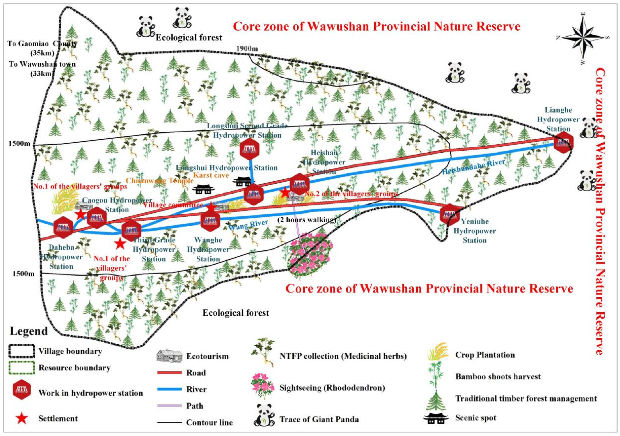
3.6.2. Planting-Dependent Communities: A Case Study of Heishan Village
- Community Profile
- 2.
- Resource Use Conflict: History and Present Situation
- 3.
- The Coping Strategies of Farmers’ Resource Utilization under Different Regulatory Intensity
- 4.
- Habitat Evolution of Giant Pandas under Different Control Intensities
- Scenario 1: Ecological priority. Under the strictest conditions, a ban on the cultivation behavior of Yalian and Coptis could stop the impact of farmers’ cultivation behavior on giant panda habitats. This results in a certain period of natural restoration of habitats in the boundary areas of the reserve, which verifies the simulation results of the ecological priority scenarios described above.
- Scenario 2: Coordinated development. The scientific and reasonable planning of Yalian and Coptis production can reduce the disturbance of planting behavior on giant panda habitats. Thus, it can drive the natural recovery of damaged land types and evolve from low-quality land types with a low vegetation index to high-quality land types; that is, the simulation results of the coordinated development scenarios in the previous section are verified.
- Scenario 3: Partial constraint. In the partial constraint scenario, collective management is conducive to avoiding the adverse selection behavior of individual operators and facilitating the supervision of local governments and conservation departments, thus effectively restricting the impact of planting behavior on giant panda habitats. Therefore, the simulation results of the partial constraint scenario in the previous section are verified.
- Scenario 4: Current situation. Under the current situation, farmers hope to maintain the existing planting scale of Yalian and Coptis and devote themselves to the development of Yalian series products. However, it is impossible to avoid the adverse selection of individual farmers to expand the planting scale. Under the background of a feminizing and aging labor force, the habitat quality of the regionally influenced Giant Panda Nature Reserve will change greatly in the next few years. The lack of institutional coordination will result in an overall decline in the habitat level (verified in Figure 5), which demonstrates changes in the habitat quality of giant pandas in the future under the current situation.
3.6.3. Comparison and Validation of Giant Panda Habitat Evolution
4. Conclusions and Discussion
Author Contributions
Funding
Institutional Review Board Statement
Informed Consent Statement
Data Availability Statement
Acknowledgments
Conflicts of Interest
References
- Yu, X.; Hu, D.; Jin, X.; Ge, X.; Yang, L.; Zhao, P.; Zhang, Q. Non–invasive determination of fecal steroid hormones relating to conservation practice in giant panda (Ailuropoda melanoleuca). Anim. Biol. 2011, 61, 335–347. [Google Scholar] [CrossRef]
- Zhang, H.; Cheng, H.; Zhu, Y.; Liu, X.; Li, D. Status and conservation strategy of giant panda habitat in Qinling tunnel area of 108 national road. J. Shaanxi Norm. Univ. 2007, 35, 116–119. (In Chinese) [Google Scholar]
- Fan, J.; Li, J.; Quan, Z.; Wu, X.; Hu, L.; Yang, Q. Impact of road construction on giant panda’s habitat and its carrying capacity in Qinling Mountains. Acta Ecol. Sin. 2011, 31, 145–149. [Google Scholar] [CrossRef]
- Liu, L.; Liu, X.; Jin, X.; Wang, Z.; Gong, M. Research on the change of giant pandas’ spatial utilization and road impacts in the Qinling Mountains. Acta Theriol. Sin. 2017, 37, 215–225. [Google Scholar] [CrossRef]
- He, M.; Chen, L.; Luo, G.; Gu, X.; Wang, G.; Ran, J. Suitable habitat prediction and overlap analysis of two sympatric species, giant panda (Ailuropoda melanoleuca) and Asiatic black bear (Ursus thibetanus) in Liangshan Mountains. Biodivers. Sci. 2018, 26, 1180–1189. [Google Scholar] [CrossRef] [Green Version]
- An, L.; Liu, J.; Ouyang, Z.; Linderman, M.; Zhou, S.; Zhang, H. Simulating demographic and socioeconomic processes on household level and implications for giant panda habitats. Ecol. Model. 2001, 140, 31–49. [Google Scholar] [CrossRef]
- Linderman, M.; An, L.; Bearer, S.; He, G.; Ouyang, Z.; Liu, J. Modeling the spatio-temporal dynamics and interactions of households, landscapes, and giant panda habitat. Ecol. Model. 2005, 183, 47–65. [Google Scholar] [CrossRef]
- Ge, Z.; Xing, W.; Li, J.; Yang, W. The impact of firewood collection by local people on the distributing of arbors around the nature reserves: A case study in Wanglang Nature Reserve for giant panda (Sichuan). Acta Ecol. Sin. 2006, 26, 97–103. [Google Scholar] [CrossRef]
- Wang, X.; Xu, W.; Ouyang, Z. Impacts of spatio-temporal changes in agricultural land on giant panda habitat: A case study in the Baicaohe Watershed of the Mid-Minshan Mountains. Biodiv. Sci. 2009, 17, 10–18. [Google Scholar] [CrossRef]
- Wang, C.; Wen, Y.; Hao, C.; Shi, J. A study on farmers’ pre-satisfaction and follow-up willingness of returning farmland in the giant panda Nature Reserve: A case on 124 households surrounding Shaanxi Changqing Nature Reserve. Resour. Sci. 2010, 32, 2030–2037. (In Chinese) [Google Scholar]
- Song, S.; Liu, Q.; Wen, Y. An analysis of determinants of natural resources dependence in the communities surrounding Qinling giant panda Protection Area. J. Zhejiang AF Univ. 2016, 33, 130–136. (In Chinese) [Google Scholar]
- Wang, C. Study on Cost-Benefit of Biodiversity Conservation in Qinling Nature Reserve; Beijing Forestry University: Beijing, China, 2011. [Google Scholar]
- Wu, Y. Research on Different Livelihood Capital Farmers of Forest Resource Dependency; Beijing Forestry University: Beijing, China, 2016. [Google Scholar]
- Shen, G.; Li, J.; Ren, Y.; Ma, Y. Indicators for giant panda’s habitat degradation and restoration. J. Beijing For. Univ. 2002, 24, 1–5. (In Chinese) [Google Scholar]
- Song, S. Qinling Giant Panda Habitat Community Development Study Based on Natural Resource Dependence; Beijing Forestry University: Beijing, China, 2013. [Google Scholar]
- Tian, Z.; Liu, X.; Fan, Z.; Liu, J.; Pimm, S.L.; Liu, L.; Garcia, C.; Songer, M.; Shao, X.; Skidmore, A.; et al. The next widespread bamboo flowering poses a massive risk to the giant panda. Biol. Conserv. 2019, 234, 180–187. [Google Scholar] [CrossRef]
- Han, H.; Wei, W.; Hu, Y.; Nie, Y.; Ji, X.; Yan, L.; Zhang, Z.; Shi, X.; Zhu, L.; Luo, Y.; et al. Diet evolution and habitat contraction of giant pandas via stable isotope analysis. Curr. Biol. 2019, 29, 664–669. [Google Scholar] [CrossRef] [PubMed]
- Duan, W.; Ma, B.; Sun, B.; Wen, Y. Dependence of the poor on forest resources: Evidence from China. Small-Scale For. 2017, 16, 487–504. [Google Scholar] [CrossRef]
- Shen, J.; Hogarth, N.J.; Hou, Y.; Duan, W. Impact of nature reserves on human well-being: Evidence from giant panda reserves in China. J. For. Econ. 2021, 36, 79–101. [Google Scholar] [CrossRef]
- Song, Z.; Zhou, W.; Gao, L. Development of giant panda Nature Reserves in China: Achievements and Problems. J. For. Econ. 2021, 36, 1–25. [Google Scholar] [CrossRef]
- Sichuan Provincial Department of Forestry and Grassland (SPDFG). The Pandas of Sichuan, The 4th Survey Report on Giant Panda in Sichuan Province; Sichuan Science and Technology Publishing House: Chengdu, China, 2015. [Google Scholar]
- Yuan, S.; Zhang, Z. Report on Comprehensive Scientific Survey in Baihe National Nature Reserve of Sichuan; Science Press: Beijing, China, 2018. [Google Scholar]
- Zhang, Z.; Huang, X.; Yuan, S. Report on Comprehensive Scientific Survey in Caopo National Nature Reserve of Sichuan; Science Press: Beijing, China, 2017. [Google Scholar]
- Zhou, L.; Zhang, X.; Jiu, Q.; Meng, X. Qinling Giant Panda: The 4th Survey Report on Giant Panda in Shaanxi Province; Shaanxi Science and Technology Press: Xian, China, 2017. [Google Scholar]
- Shi, Z.; Wu, Q. The 4th Survey Report on Giant Panda in Gansu Province; Gansu Science and Technology Press: Lanzhou, China, 2017. [Google Scholar]
- He, W.; Yan, J.; Zhou, H.; Li, X. The factors influencing rural household firewood consumption: A theoretical model and empirical research of a typical area in Chongqing Municipality. Acta Ecol. Sin. 2016, 36, 1369–1379. (In Chinese) [Google Scholar]
- Tai, X. Analysis on influencing factors of fuelwood consumption of farmers in Western Mountainous Area. Chin. Rural Econ. 2011, 85–91, 96. (In Chinese) [Google Scholar]
- Li, W.; Zhao, L. Phenomenon of agricultural labor force feminization and its influence on agricultural production. Chin. Rural Econ. 2009, 25, 61–69. (In Chinese) [Google Scholar]
- Xiang, Y.; Qi, C.; Hu, X. The Influence of Aging, Concurrent Industry and Feminization on the Household Production Factors Input:An Empirical Analysis based on National Rural Fixed Observation Point Data. J. Stat. Inf. 2018, 33, 109–115. (In Chinese) [Google Scholar]
- Song, Z.; Gao, L. Effect of feminization of labor force on farmers’ firewood utilization behavior in nature reserves:evidence from Sichuan Province. J. Agro-For. Econ. Manag. 2021, 20, 356–365. (In Chinese) [Google Scholar]
- Yue, R.; Li, L.; Huang, J. The impact of rural tourism on the active aging in mountain areas: A case study of Dujiangyan City, China. Mt. Res. 2018, 36, 774–783. (In Chinese) [Google Scholar]
- He, G.; Chen, X.; Scott, B.; Manuel, C.; Angela, M.; An, L.; Zhou, S.; Linderman, M.; Ouyang, Z.; Stuart, G.; et al. Spatial and temporal patterns of fuelwood collection in Wolong Nature Reserve: Implications for panda conservation. Landsc. Urban Plan. 2009, 92, 1–9. [Google Scholar] [CrossRef]
- Liang, Y.; Fan, J.; Sun, W.; Han, X.; Sheng, K.; Ma, H.; Xu, Y.; Wang, C. The influencing factors of rural household energy consumption structure in mountainous areas of Southwest China: A case study of Zhaotong City of Yunnan Province. Acta Geogr. Sin. 2012, 67, 221–229. (In Chinese) [Google Scholar]
- Wang, Z.; Xu, W.; Ouyang, Z.; Liu, J.; Xiao, Y.; Chen, Y.; Zhao, L.; Huang, J. Application of ecological-niche factor analysis in habitat assessment of giant pandas. Acta Ecol. Sin. 2008, 28, 821–828. (In Chinese) [Google Scholar]
- Carlos, L.A.; Ella, V.D. Of pandas, fossils, and bamboo forests: Ecological niche modeling of the giant panda (Ailuropoda melanoleuca) during the Last Glacial Maximum. J. Mammal. 2021, 102, 718–730. [Google Scholar] [CrossRef]
- Wang, J.; Liu, Y.; Shi, T.; Wu, G. Analysis of land-use changes in Shankou mangrove forest natural reserve using CA-Markov model. J. Anhui Agric. Univ. 2016, 43, 780–786. (In Chinese) [Google Scholar]
- Zhou, H.; Lei, G.; Zhao, Y.; Lu, C.; Zhang, B. Simulation of dynamics of land use in Naoli River Valley based on CA-Markov Model. J. Ecol. Rural Environ. 2016, 32, 252–258. [Google Scholar] [CrossRef]
- Eduardo, G.; Patrícia, A.; Arnaud, B.; Jorge, R.; Michael, B. Farming under urban pressure: Farmers’ land use and land cover change intentions. Appl. Geogr. 2019, 102, 58–70. [Google Scholar] [CrossRef]
- Song, K.; Zhao, J.; Ouyang, W.; Zhang, X.; Hao, F. LUCC and landscape pattern variation of wetlands in warm-rainy Southern China over two decades. Procedia Environ. Sci. 2010, 2, 1296–1306. [Google Scholar] [CrossRef] [Green Version]
- Nurwanda, A.; Zain, A.F.M.; Rustiadi, E. Analysis of land cover changes and landscape fragmentation in Batanghari Regency, Jambi Province. Procedia-Soc. Behav. Sci. 2016, 227, 87–94. [Google Scholar] [CrossRef] [Green Version]
- Vincent, O.O.; Pieter, R.O.; Christiaan, V.D.T.; Su, Z. Impact of land use and land cover transitions and climate on evapotranspiration in the Lake Naivasha Basin, Kenya. Sci. Total Environ. 2019, 682, 19–30. [Google Scholar] [CrossRef]
- Long, H.; Li, X. Spatio-temporal modelling of land use changes in transect of the Yangtse River and corresponding countermeasures. Geogr. Res. 2001, 20, 660–668. (In Chinese) [Google Scholar]
- Ge, D.; Long, H.; Yang, R. The pattern and mechanism of farmland transition in China from the perspective of per capita farmland area. Resour. Sci. 2018, 40, 273–283. (In Chinese) [Google Scholar]
- Castella, J.C.; Verburg, P.H. Verburg. Combination of process-oriented and pattern-oriented models of land-use change in a mountain area of Vietnam. Ecol. Model. 2007, 202, 410–420. [Google Scholar] [CrossRef]
- Peng, S.; Qian, J.; Chen, J.; Chen, X.; Ma, Y. Spatio-temporal dynamic simulation of land use change of typical oasis cities in arid areas based on CLUE-S Model: A case study of Kuitun River Basin in Xinjiang. Geogr. Geo-Inf. Sci. 2018, 34, 61–67, 129. (In Chinese) [Google Scholar]
- Hulst, R.V. On the dynamics of vegetation: Markov chains as models of succession. Vegetatio 1979, 40, 3–14. [Google Scholar] [CrossRef]
- Chu, L.; Zhang, X.; Wang, T.; Li, Z.; Cai, C. Spatial-temporal evolution and prediction of urban landscape pattern and habitat quality based on CA-Markov and InVEST Model. Chin. J. Appl. Ecol. 2018, 29, 4106–4118. (In Chinese) [Google Scholar]
- Hou, X.; Chang, B.; Yu, X. Land use change in Hexi corridor based on CA-Markov methods. Trans. Chin. Soc. Agric. Eng. 2004, 20, 286–291. (In Chinese) [Google Scholar]
- Han, L.; He, Z.; Tang, J.; Li, S. A Study on Dynamic Simulation of Urban Growth and Land Value Increment Based on CA Model. Geogr. Geo-Inf. Sci. 2003, 19, 32–35. (In Chinese) [Google Scholar]
- Lin, Q.; Luo, G.; Chen, X. (2005). Review of Land-use Model. Prog. Geogr. 2005, 24, 79–87. (In Chinese) [Google Scholar]
- Yang, G.; Wu, Z.; Zhu, G. Analyzing and modeling land use pattern changes in rapid urbanization of area: A case study of Guangzhou City, China. Trans. Chin. Soc. Agric. Eng. 2006, 22, 218–221. (In Chinese) [Google Scholar]
- Pontius, R.G. Quantification error versus location error in comparison of categorical maps. Photogramm. Eng. Remote Sens. 2000, 66, 1011–1016. [Google Scholar] [CrossRef]
- He, D.; Jin, F.; Zhou, J. The changes of land use and landscape pattern based on Logistic-CA-Markov Model: A case study of Beijing-Tianjin-Hebei Metropolitan Area. Sci. Geogr. Sin. 2011, 31, 903–910. (In Chinese) [Google Scholar]
- Liu, R.; Zhu, D.; Zhu, Z.; Yang, W. Analysis of the driving forces of urban sprawl in Dezhou City based on a Logistic Regression Model. Resour. Sci. 2009, 31, 1919–1926. (In Chinese) [Google Scholar]
- Xie, H.; Li, B. Driving forces analysis of land-use pattern changes based on logistic regression model in the farming-pastoral zone: A case study of Ongiud Banner, Inner Mongolia. Geogr. Res. 2008, 27, 294–304. (In Chinese) [Google Scholar]
- Pontius, R.G.; Schneider, L.C. Land-cover change model validation by an ROC method for the Ipswich watershed, Massachusetts, USA. Agric. Ecosyst. Environ. 2001, 85, 239–248. [Google Scholar] [CrossRef]
- Sakal, O. Methodological approaches for the evaluation of ecosystem services. Econ. Nat. Environ. 2016, 71–78. Available online: https://ideas.repec.org/a/ene/journl/y2016p71-78.html (accessed on 27 August 2022).
- Sun, X.; Liu, H.; Xianlan, F. Effects of Land Use Change on Wetland Landscapes in the Yancheng Nature Reserve. Resour. Sci. 2010, 32, 1741–1745. [Google Scholar]


| 2017 | Ecological Priority | Coordinated Development | Partial Constraint | Current Situation | ||
|---|---|---|---|---|---|---|
| Farmland | 7.96 | 0 | 1.44 | 0.55 | 8.06 | |
| Woodland | 74.20 | 87.77 | 81.50 | 83.03 | 72.27 | |
| Grassland | 15.09 | 10.45 | 15.09 | 14.58 | 14.53 | |
| Waters | 1.97 | 1.78 | 1.97 | 1.84 | 2.05 | |
| Construction land | 0.72 | 0 | 0 | 0 | 1.55 | |
| Unutilized land | 0.06 | 0 | 0 | 0 | 1.54 | |
| Constraint of human activity ➀ | Surrounding village | √ | ◯ | √ | √ | √ |
| Experimental zone | × | × | √ | ◯ | × | |
| Buffer zone | × | × | × | × | × | |
| Core zone | × | × | × | × | × | |
| Additional regulatory regime from government decisions ➁ | ◯ | √ | × | ◯ | ◯ | |
| Change of labor force structure ➂ | Feminization of farmer labor force | √ | √ | × | ◯ | √ |
| Aging of farmer labor force | √ | √ | × | ◯ | √ | |
| Level | Value Range | Description |
|---|---|---|
| LL | 0~0.2 | Lowest habitat quality |
| LH | 0.2~0.6 | Lower habitat quality |
| M | 0.6~0.7 | Moderate habitat quality |
| HL | 0.7~0.9 | Higher habitat quality |
| HH | 0.9~1 | Highest habitat quality |
| Habitat Quality Level | Area | Change in Area | ||||
|---|---|---|---|---|---|---|
| 2015 | 2017 | 2015–2017 | ||||
| km2 | % | km2 | % | km2 | % | |
| LL (Lowest habitat quality) | 0.0018 | 0.0005 | 0.1237 | 0.0339 | 0.1219 | 0.0334 |
| LH (Lower habitat quality) | 0.1046 | 0.0287 | 1.4974 | 0.4103 | 1.3927 | 0.3817 |
| M (Middle habitat quality) | 0.0049 | 0.0013 | 0.3311 | 0.0907 | 0.3262 | 0.0894 |
| HL (Higher habitat quality) | 5.9789 | 1.6385 | 3.6883 | 1.0108 | −2.2906 | −0.6277 |
| HH (Highest habitat quality) | 358.8097 | 98.3310 | 359.2595 | 98.4542 | 0.4499 | 0.1233 |
| Variable | Ecological Priority | Coordinated Development | Partial Constraint | Current Situation | ||||
|---|---|---|---|---|---|---|---|---|
| Regression Coefficient | Standard Deviation | Regression Coefficient | Standard Deviation | Regression Coefficient | Standard Deviation | Regression Coefficient | Standard Deviation | |
| X1 | 0.003 | 0.000 | 0.003 | 0.000 | 0.003 | 0.000 | 0.003 | 0.000 |
| X2 | 0.012 | 0.001 | 0.012 | 0.001 | 0.015 | 0.001 | 0.013 | 0.001 |
| X3 | −0.003 | 0.000 | −0.003 | 0.000 | −0.003 | 0.000 | −0.003 | 0.000 |
| X4 | 1.572 | 0.431 | 1.599 | 0.425 | 1.591 | 0.420 | 1.577 | 0.421 |
| X5 | 24.445 | 0.634 | 13.844 | 0.430 | 18.269 | 0.467 | 2.468 | 0.366 |
| X6 | −8.222 | 0.291 | −3.747 | 0.415 | −9.783 | 0.526 | −6.896 | 0.381 |
| X7 | −6.765 | 0.200 | −3.907 | 0.380 | −4.878 | 0.505 | −4.180 | 0.422 |
| X8 | −2.647 | 0.131 | −2.185 | 0.176 | −2.517 | 0.238 | −0.230 | 0.179 |
| Constant | −6.995 | 0.092 | −6.617 | 0.089 | −5.393 | 0.083 | −8.004 | 0.090 |
| ROC | 0.854 | 0.867 | 0.875 | 0.889 | ||||
| Land Use Type | Ecological Priority | Coordinated Development | Partial Constraint | Current Situation | Land Use Type | Ecological Priority | Coordinated Development | Partial Constraint | Current Situation | ||
|---|---|---|---|---|---|---|---|---|---|---|---|
| Farmland | Area (km2) | 0 | 0.2704 | 0.1036 | 1.5159 | Water | Area (km2) | 0.3351 | 0.3699 | 0.3463 | 0.3853 |
| Proportion (%) | 0 | 0.07 | 0.03 | 0.42 | Proportion (%) | 0.09 | 0.10 | 0.09 | 0.11 | ||
| ROC (%) | −100.00 | −81.94 | −93.08 | 1.22 | ROC (%) | −9.41 | 0.00 | −6.40 | 4.16 | ||
| Woodland | Area (km2) | 362.5992 | 361.4209 | 361.7085 | 359.6832 | Construction land | Area (km2) | 0 | 0 | 0 | 0.2921 |
| Proportion (%) | 99.37 | 99.05 | 99.13 | 98.57 | Proportion (%) | 0 | 0 | 0 | 0.08 | ||
| ROC (%) | 0.71 | 0.38 | 0.46 | −0.10 | ROC (%) | −100.00 | −100.00 | −100.00 | 116.40 | ||
| Grassland | Area (km2) | 1.9666 | 2.8398 | 2.7427 | 2.7341 | Unutilized land | Area (km2) | 0 | 0 | 0 | 0.2904 |
| Proportion (%) | 0.54 | 0.78 | 0.75 | 0.75 | Proportion (%) | 0 | 0 | 0 | 0.08 | ||
| ROC (%) | −30.75 | −0.00 | −3.42 | −3.73 | ROC (%) | −100.00 | −100.00 | −100.00 | 2400.20 | ||
| Land Use Type | Ecological Priority | Coordinated Development | Partial Constraint | Current Situation | |
|---|---|---|---|---|---|
| HH | Area (km2) | 362.5992 | 361.4209 | 361.7085 | 359.6832 |
| Proportion (%) | 99.37 | 99.05 | 99.13 | 98.57 | |
| HL | Area (km2) | 1.9666 | 2.8398 | 2.7427 | 2.7341 |
| Proportion (%) | 0.54 | 0.78 | 0.75 | 0.75 | |
| M | Area (km2) | 0.3351 | 0.3699 | 0.3463 | 0.3853 |
| Proportion (%) | 0.09 | 0.10 | 0.09 | 0.11 | |
| LH | Area (km2) | 0 | 0.2704 | 0.1036 | 1.5159 |
| Proportion (%) | 0 | 0.07 | 0.03 | 0.42 | |
| LL | Area (km2) | 0 | 0 | 0 | 0.5825 |
| Proportion (%) | 0 | 0 | 0 | 0.16 |
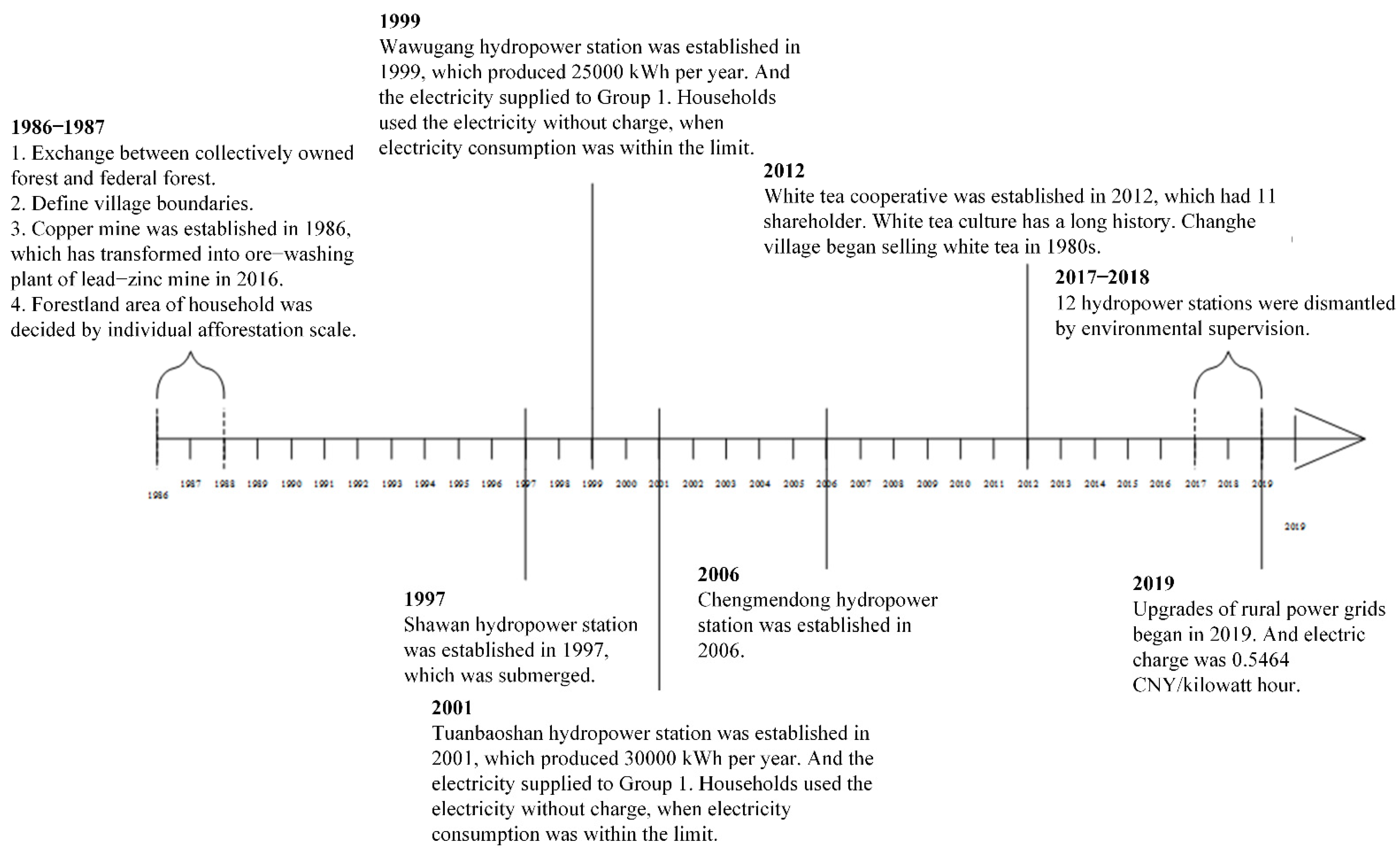
| Year | Event |
|---|---|
| 1986–1987 |
|
| 1997 | Shawan hydropower station was established in 1997 and subsequently submerged. |
| 1999 | Wawugang hydropower station was established in 1999, which produced 25,000 kWh per year. The electricity was supplied to Group 1 households who used the electricity without charge when electricity consumption was within limits. |
| 2001 | Tuanbaoshan hydropower station was established in 2001, which produced 30,000 kWh per year. The electricity was supplied to Group 1 households who used the electricity without charge when electricity consumption was within limits. |
| 2006 | Chengmendong hydropower station was established in 2006. |
| 2012 | The white tea cooperative was established in 2012 with 11 shareholders. White tea culture has a long history. Changhe Village began selling white tea in the 1980s. |
| 2017–2018 | Twelve hydropower stations were dismantled under environmental supervision. |
| 2019 | Upgrades of rural power grids began in 2019. The electric charge was 0.5464 CNY/kilowatt hour. |
| Category | Scenario Content |
|---|---|
| Scenario 1: Ecological priority | |
| Content |
|
| Coping strategies |
|
| Scenario 2: Coordinated development | |
| Content |
|
| Coping strategies |
|
| Scenario 3: Partial constraint | |
| Content |
|
| Coping strategies |
|
| Scenario 4: Current situation | |
| Content |
|
| Coping strategies |
|
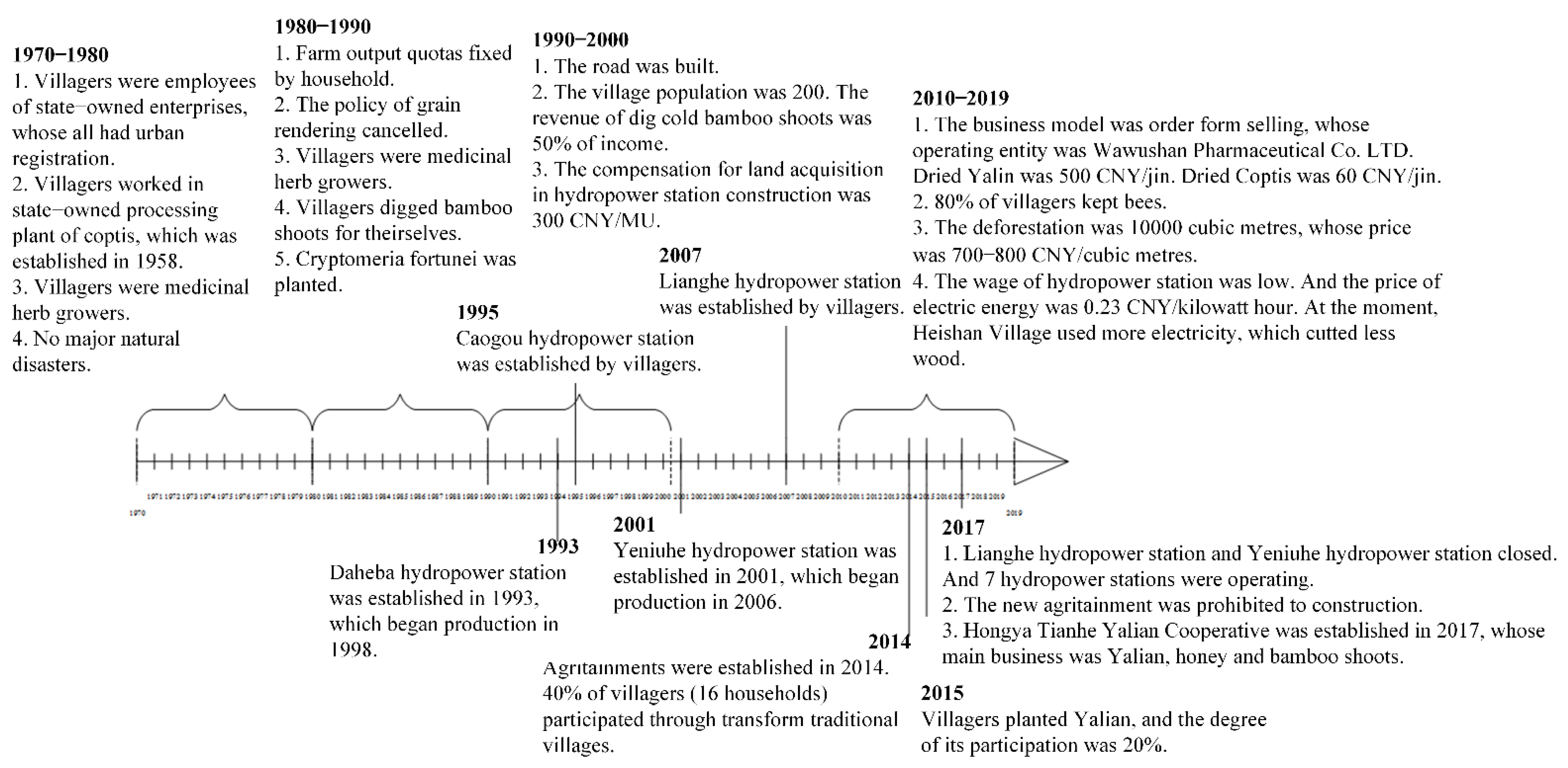
| Year | Event |
|---|---|
| 1970–1980 |
|
| 1980–1990 |
|
| 1990–2000 |
|
| 1993 | Daheba hydropower station was established in 1993, which began production in 1998. |
| 1995 | Caogou hydropower station was established by villagers. |
| 2001 | Yeniuhe hydropower station was established in 2001, which began production in 2006. |
| 2007 | Lianghe hydropower station was established by villagers. |
| 2010–2019 |
|
| 2014 | Agritainments were established in 2014. A total of 40% of villagers (16 households) participated through transforming traditional villages. |
| 2015 | Villagers planted Yalian, and participation was 20%. |
| 2017 |
|
| Category | Scenario Content |
|---|---|
| Scenario 1: Ecological priority | |
| Content |
|
| Coping strategies |
|
| Scenario 2: Coordinated development | |
| Content |
|
| Coping strategies |
|
| Scenario 3: Partial constraint | |
| Content |
|
| Coping strategies |
|
| Scenario 4: Current situation | |
| Content |
|
| Coping strategies |
|
| Forestry Resource-Dependent Communities | Planting-Dependent Communities | ||
|---|---|---|---|
| Category | Data Validation | Category | Data Validation |
| Scenario 1: Ecological priority | Figure 5 Ecological priority | Scenario 1: Ecological priority | Figure 5 Ecological priority |
| Firewood logging is prohibited. | No cultivation at all. | ||
| Scenario 2: Coordinated development | Figure 5 Coordinated development | Scenario 2: Coordinated development | Figure 5 Coordinated development |
| Commodity forest felling index meets demand and firewood comes from selective felling of commodity forest. | Reasonable planning of Yalian and Coptis production to minimize the impact on panda habitats and extend the industrial chain. | ||
| Scenario 3: Partial constraint | Figure 5 Partial constraint | Scenario 3: Partial constraint | Figure 5 Partial constraint |
| To give up free energy in exchange for ecotourism development, reduce the use of firewood. | To reduce disturbance to the habitats of giant pandas, joint operation, and orderly development should be carried out to avoid an excessive commercial resource utilization mode. | ||
| Scenario 4: Current situation | Figure 5 Current situation | Scenario 4: Current situation | Figure 5 Current situation |
| The contradiction between protection and development still exists and fuelwood harvesting cannot be avoided. | Maintain the existing cultivation scale of Yalian and Coptis, but individual farmers cannot avoid adverse selection. | ||
Publisher’s Note: MDPI stays neutral with regard to jurisdictional claims in published maps and institutional affiliations. |
© 2022 by the authors. Licensee MDPI, Basel, Switzerland. This article is an open access article distributed under the terms and conditions of the Creative Commons Attribution (CC BY) license (https://creativecommons.org/licenses/by/4.0/).
Share and Cite
Song, Z.; Wu, B.; Xiong, W.; Gao, L.; Li, Y. Quantifying the Evolution of Giant Panda Habitats in Sichuan Province under Different Scenarios. Diversity 2022, 14, 865. https://doi.org/10.3390/d14100865
Song Z, Wu B, Xiong W, Gao L, Li Y. Quantifying the Evolution of Giant Panda Habitats in Sichuan Province under Different Scenarios. Diversity. 2022; 14(10):865. https://doi.org/10.3390/d14100865
Chicago/Turabian StyleSong, Zhenjiang, Baoshu Wu, Wenguang Xiong, Lan Gao, and Yi Li. 2022. "Quantifying the Evolution of Giant Panda Habitats in Sichuan Province under Different Scenarios" Diversity 14, no. 10: 865. https://doi.org/10.3390/d14100865