Article

Odonata from Iberá Wetland System (Corrientes, Argentina) Are Regional Biogeographic Schemes Useful to Assess Odonata Biodiversity and Its Conservation?

by
Alejandro del Palacio
,
Federico Lozano
,
Lia S. Ramos
,
María de las Mercedes Navarro
and
Javier Muzón
*
Laboratorio de Biodiversidad y Genética Ambiental—BioGeA, Universidad Nacional de Avellaneda, Avellaneda B1870, Argentina
*
Author to whom correspondence should be addressed.
Diversity 2022, 14(10), 842; https://doi.org/10.3390/d14100842
Submission received: 20 July 2022 / Revised: 28 September 2022 / Accepted: 1 October 2022 / Published: 6 October 2022
(This article belongs to the Special Issue Diversity, Ecology and Evolution of Odonata)

Abstract

:
Regionalization schemes reflect different macroscale distribution patterns and show large areas characterized by a common natural history, resulting in similar associations of biotic and abiotic features. Freshwater biota and terrestrial biota do not respond in the same way to environmental variables. The Iberá Depression, one of the largest wetlands in South America, is recognized in many schemes either as a functional unit or as an area with an ecotonal character. We used the distributional data of 128 species of Odonata, from a total of 103 collection sites from Corrientes and Misiones provinces, to test if Iberá functions as an ecological and functional unit, based on the Odonata distribution patterns. In addition, we tested if their distribution patterns fit into the most widespread regionalization schemes (hydrological basins, biogeographical provinces and ecoregions) used in Argentina. The Iberá Depression was not recovered as a functional unit; its sub-basins are more related to external basins than to each other. Neither the ecoregion nor the biogeographical schemes are suitable to explain the distribution patterns of the Odonata. The Odonata seem to respond to the availability of particular wetlands (e.g., ponds, streams, rivers, swamps, etc.), or to specific physical characteristics, such as the type of sediment, the availability of oxygen, etc., instead of to biogeographical or ecoregional schemes.

1. Introduction

Biological inventories are the most direct way of knowing the diversity of a region [1]. They provide valuable information about the current status of the diversity, as they provide data on species richness, the presence of native, endemic, or threatened species, distribution patterns, etc. In addition, inventories are essential tools for monitoring diversity, which is essential to understand the influence of different impacts, natural or anthropogenic, or the effectiveness of different types of management actions, among others. It can be assumed that areas can be valued from the point of view of the singularity of their main biotic components and, then, priorities can be established in the development of conservation policies. On the other hand, when biological inventories are not complete or unavailable for a certain area, regionalization schemes based on biotic and/or abiotic components (e.g., phytogeographic, zoogeographic, biogeographic, ecoregional, hydrological basins) are common tools in order to assess both their biodiversity and conservation [2,3].
The rationale behind most of these regionalization schemes is to show different macroscale distribution patterns (i.e., plants, animals, biota and ecosystems), and to show large areas characterized by a common natural history, resulting in the similar associations of biotic and abiotic features. For almost all schemes, the main data used for their elaboration come from the distribution of terrestrial plants; this is even the case for the delimitation of ecoregions (i.e., areas based on macroscale patterns of ecosystems determined by climate) where vegetation is used as a surrogate for climate because it is considered a tangible expression of it [4]. Nevertheless, there are several problems with establishing these macroscale patterns. Most of them are related to the stability and the uniformity of the factors considered at different scales (e.g., the changing nature of the climate, the different stages of vegetation succession, potential vs. actual vegetation, anthropogenic modifications), heterogeneity between climate zones given by geomorphology, boundaries between units, available data, etc. In addition to this, it must be considered that not all taxa respond in the same way to the environmental variables and, therefore, their distribution patterns will not coincide. This is more evident or critical when considering the aquatic biota. The discrepancy between freshwater and terrestrial components takes another level of significance when it is noted that very few phyla have evolved to efficiently become terrestrial, becoming completely independent of the aquatic environment (e.g., some groups of Arthropoda and Chordata). This kind of discrepancy could lead to wrong conclusions or decisions regarding freshwater taxa. In addition, there are some issues when applying these schemes to study terrestrial faunal components: in general, it can be assumed that the distribution patterns of groups that are directly dependent on vegetation (for example, herbivorous animals, or animals that require a special plant physiognomy to nest or reproduce) will coincide more precisely with the current schemes. However, in those cases with less dependence on the vegetation, for example generalist predators or even those that have amphibian life cycles, such as Odonata, the non-coincidence with the schemes may be greater. Obviously, taxa such as Odonata establish multiple relationships with plants, not only aquatic, but also terrestrial, such as a preference for shady or sunny places, substrates for oviposition, etc.; but these relationships are not generally established at a specific level, rather with ecological types (i.e., trees, shrubs, grasses).
The order Odonata in Argentina is represented by 282 species, which can be divided into two main faunistic components [5]. One of them, with less richness, but with a higher level of endemism, is the Subantarctic component, distributed in Patagonia and characterized by presenting biogeographical relationships with Australia, New Zealand, and Tasmania [6]. The other one is the Neotropical component, in the north and center of the country between 34° and 36° S, where the southernmost limits of many widespread American genera are found (e.g., Acanthagrion, Argia, Hetaerina, Erythemis, Miathyria, Micrathyria, Perithemis, Tauriphila, and Tramea). One of the most diverse areas within the Neotropical component is the Iberá wetland system [7].
The Iberá wetland system (Figure 1a) represents one of the most biodiverse wetlands in southern South America, due to its extension, environmental singularity (i.e., esteros wetlands) and probably because of its ecotonal nature between the Paranaense forests and the Pampaean grasslands [7,8]. Several faunistic inventories have been published that account for this diversity [7,8,9,10,11,12,13,14]. It is a complex of marshes, ponds and swamps mixed with lotic environments connected by wide interface areas, with a changing physiognomy due to the changes in water levels. Iberá singularity is due also to the development of the esteros, a particular type of shallow wetland with a marked thermocline that supports large patches of floating vegetation called embalsados. The embalsados, or floating islands, are a common vegetal formation in the Parana basin, formed from a root cluster of a few dominant hydrophytes with high amounts of organic matter [15]. It is worth mentioning that Iberá has suffered during the last two years from strong pressure caused by natural and intentional fires. In 2022 alone 900 thousand hectares, which represents more than 10% of the surface of the province [16], were affected.
In addition, within the Iberá wetland system different regionalization schemes, based mainly on phytogeographical aspects, have given disparate results: following the classic biogeographic scheme [17] three provinces converge (Espinal, Chaco and Paranaense provinces); and following the ecoregional proposal [18], two ecoregions converge (Campos y Malezales and Esteros del Iberá). This complexity gives the area an ecotonal character [7]. These very different results allow us to evaluate their representativeness when analyzing a component of the aquatic biota. On a hydrological scale, the basins (especially the Iberá Depression) are delimited by physical barriers that hinder the distribution of most aquatic species. Due to this, a higher biotic similarity between sites within a basin is expected than between different basins.
The main objective of this work is to assess if Iberá, one of the most speciose areas in Argentina for odonates, and behaves as a functional and ecological unit based on the Odonata diversity, as well as to test how their distribution patterns fit into previous regionalization schemes (hydrological basins, biogeographical provinces and ecoregions). In addition, an updated inventory from Iberá is provided.

2. Materials and Methods
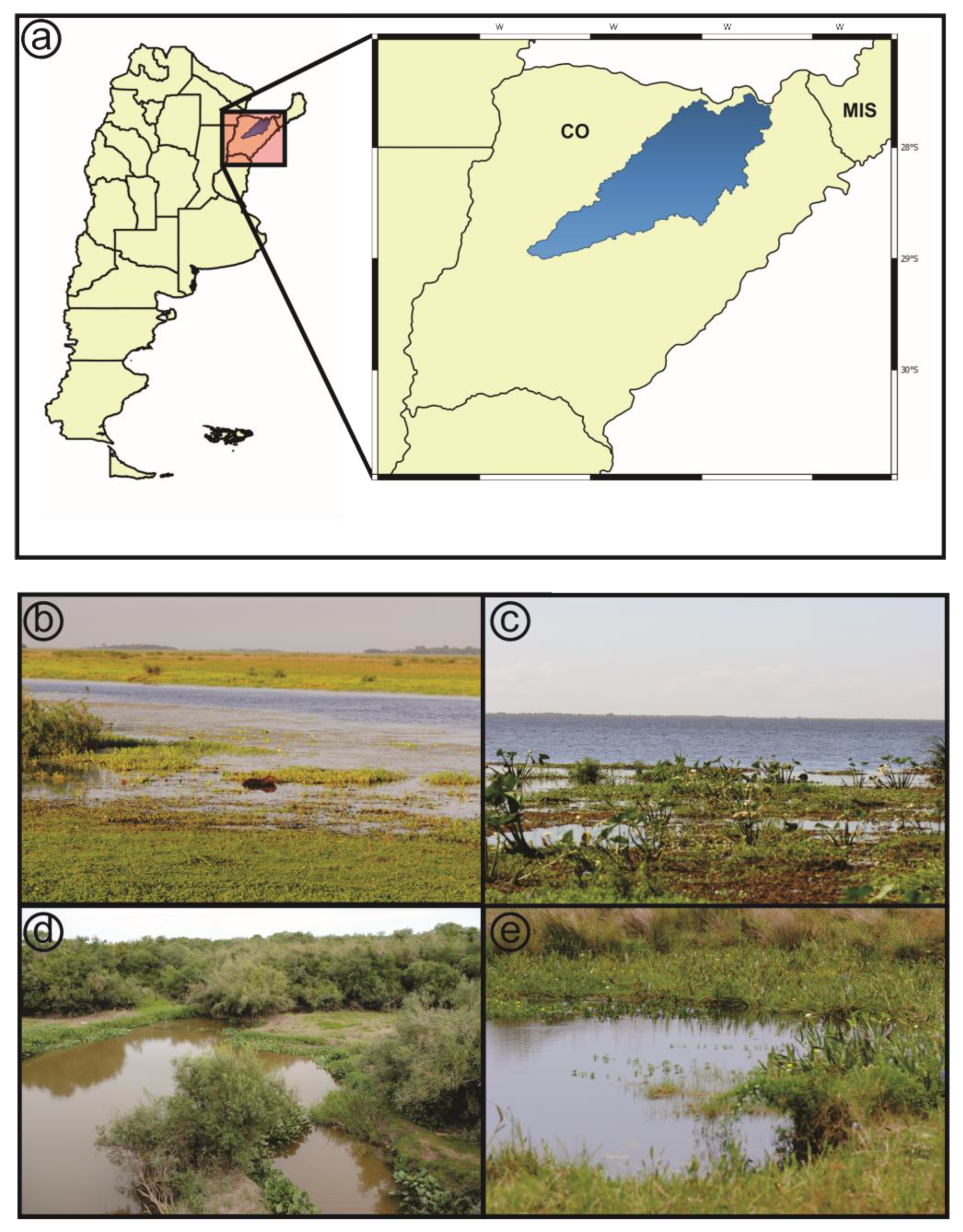
2.1. Study Area

The province of Corrientes is characterized by its remarkable and diverse wetlands (Figure 1b–e). Physiographically, the central sector of Corrientes constitutes a low-lying area that receives the name of Región Deprimida (Depressed Region) [19], which is different from the adjacent areas in terms of lithological and geomorphological features (Figure 2a). This area includes the Iberá Depression, a hydrological basin, and the marshy environments associated with the fluvial valleys of the Corriente, Batel Batelito and Santa Lucía rivers (Figure 2b) [20].
The Iberá Depression contains a complex of wetlands of about 14,000 km2 with permanent or semi-permanent water, with different types of aquatic vegetation, all of which make the region one of the largest macro-wetlands in the world. It is located in the upper basin of the Corriente River and drains into the Paraná River. The Iberá Depression can be divided into three sub-basins: Iberá, Carambolas and Naciente del Río Corriente [21], each of them with particular dynamics (Figure 2a).
The term Iberá has also been used in different regionalization schemes due to its environmental complexity. Therefore, the geographical extent of Iberá strictly depends on how it is defined. Morrone et al. [22] have referred to the Esteros del Iberá province (Figure 3a) which is similar to the Riverine district, as defined by Apodaca et al. [23], they have referred to Iberá as a vast area covering the flood valleys of the Paraguay–Parana fluvial axis, from north-eastern Argentina and southern Paraguay to the Parana Delta, and the Uruguay River from southern Brazil to the Rio de la Plata.
Brown and Pacheco [18] have recognized the Esteros del Iberá Ecoregion (Figure 3b), a more restricted area that occupies 12,300 km2 in the northwest of Corrientes province in Argentina. They have subdivided this area into two different zones, taking into account different vegetation structures: Esteros del Iberá and Parque Chaqueño Correntino.
There is a preliminary Odonata inventory from the Iberá Depression [7], in which 38 species within 21 genera were recorded from surveys done between 1999 and 2005.

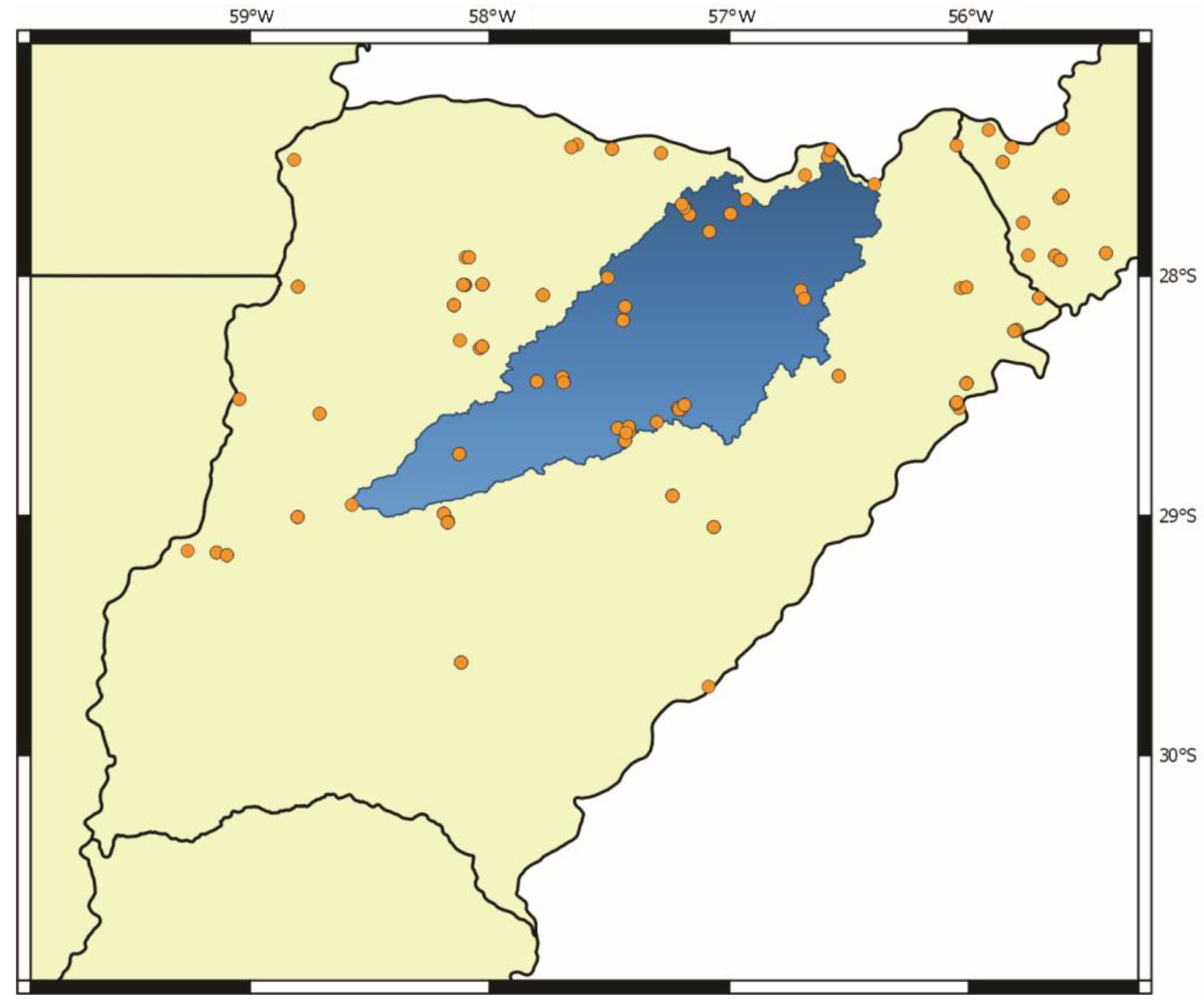
2.2. Sampling Procedures

Odonata were collected with aerial nets, fixed by injection with 96% alcohol and then dehydrated with silica gel; once dry they were stored in plastic envelopes in the Laboratorio de Biodiversidad y Genética Ambiental, Universidad Nacional de Avellaneda (BioGeA) collection. Collections were made from September 2009 to April 2014, preferably between 10:00 and 14:00 on sunny days, when the adults were more active.

2.3. Regionalization Schemes

For the analyses, three regionalization schemes were used. These were selected based on the possibility of testing the internal relationships of the Iberá Depression. Therefore, Morrone et al. [22] and Apodaca et al. [23] were not used, since the Iberá Depression is contained within a much larger area, and no subdivisions have been provided by any of these authors:
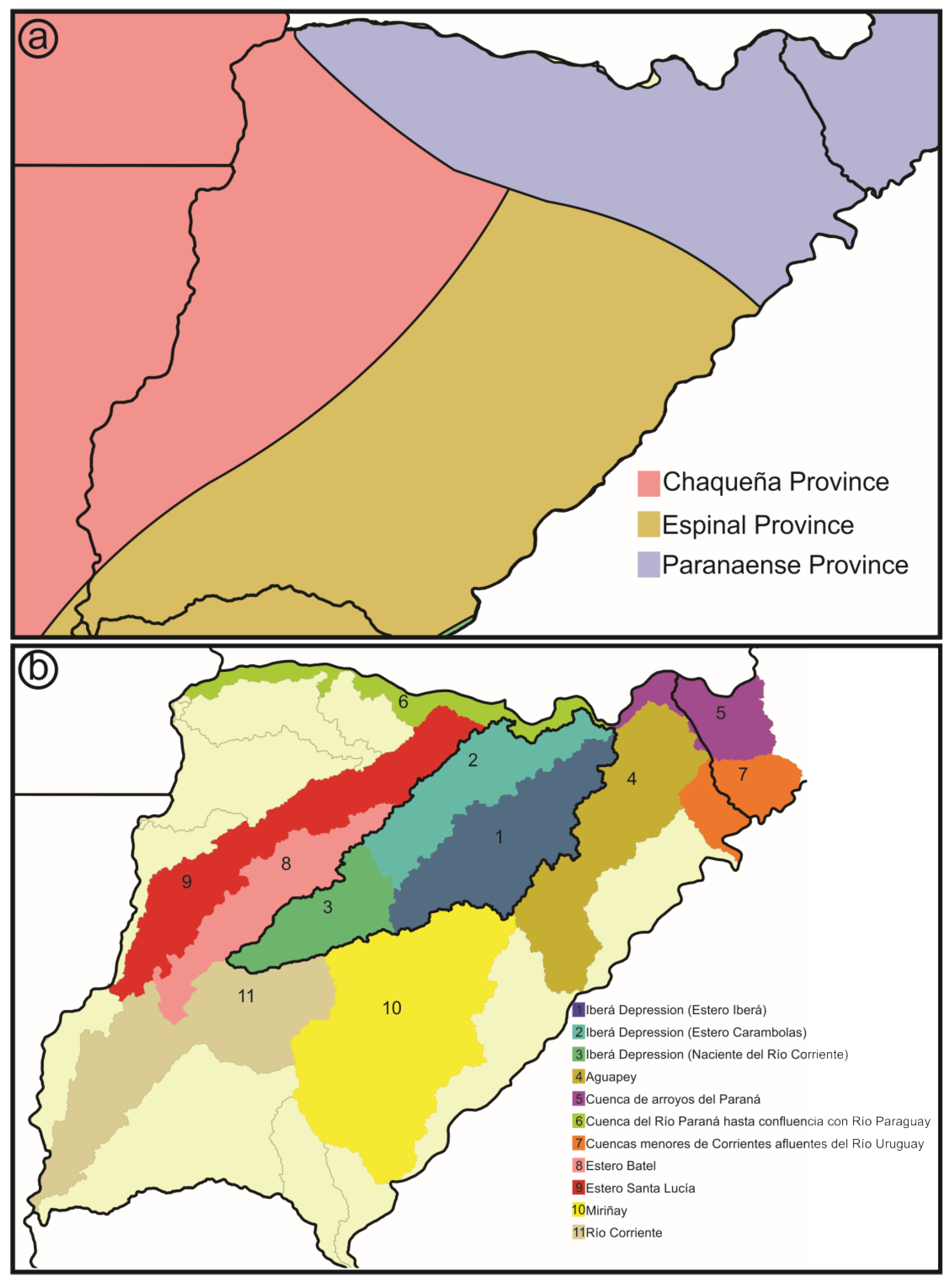
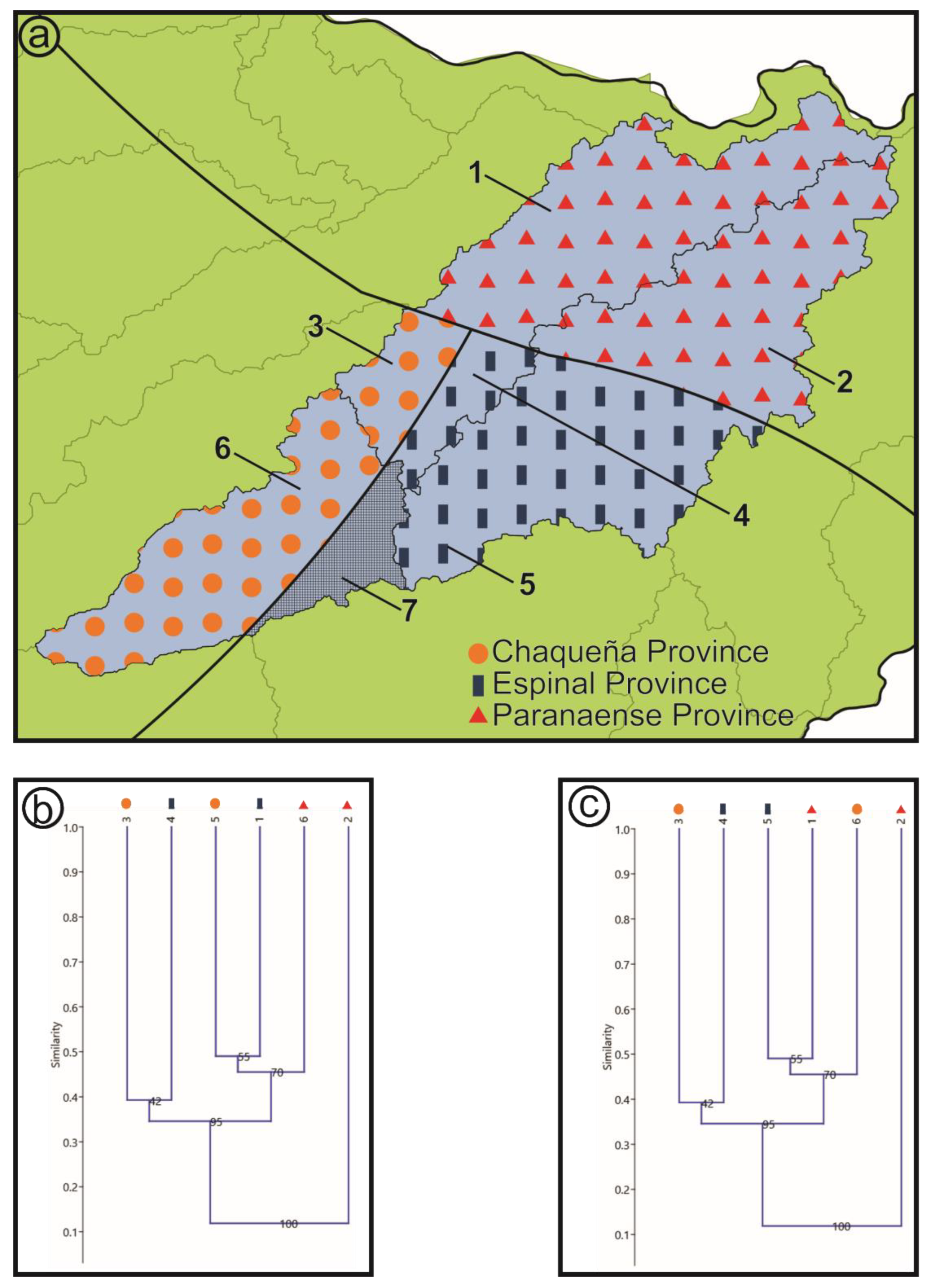
  • Biogeographic provinces sensu Cabrera and Willink [17]: This scheme proposes a hierarchical partition, which is a divisive, non-agglomerative classification of the regions into domains, provinces, and districts. In this categorization, the successive levels mainly based on the phytogeographic hierarchy, from domain to district, are carried out by the presence of endemisms and predominance of families and species [18,24]. The vegetation of the Neotropical and Subantarctic sectors of Argentina is then classified into 12 provinces [24], three of them are represented in the area: Espinal, Chaqueña and Paranaense (Figure 4a).
  • Ecoregions sensu Brown and Pacheco [18]: This ecoregional scheme was developed by a panel of experts in flora and fauna. It recognizes 18 ecoregions for the country, three of them are represented in the study area: Chaco Húmedo, Esteros del Iberá and Campos y Malezales (Figure 3b).
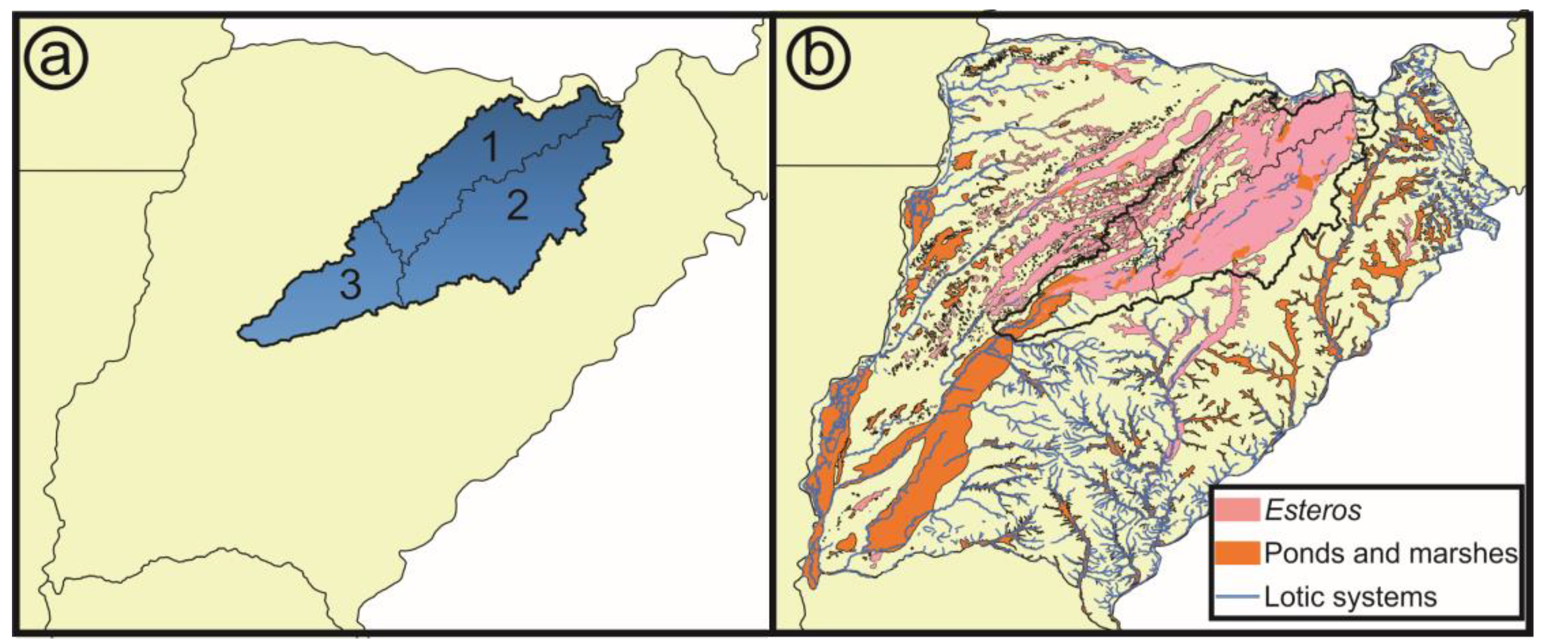
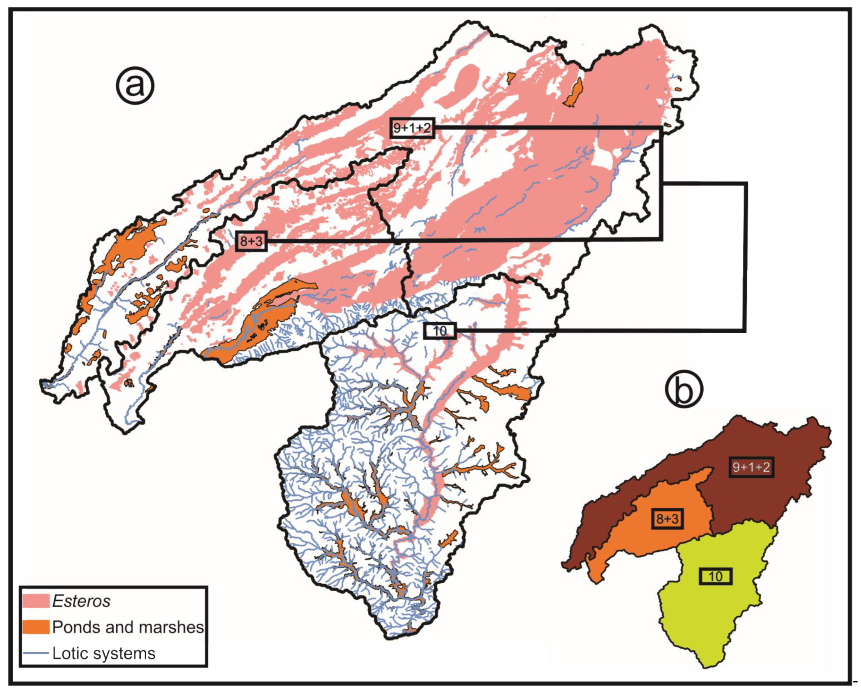
  • Hydrological basins from Corrientes gathered from the Subsecretaría de Recursos Hídricos of Corrientes [21]: According to this scheme, the Iberá Depression is divided into three different sub-basins (Iberá, Carambolas and Naciente del Río Corriente). Surrounding these, there are eight basins that were used to test if the Iberá Depression functions as a unit (Aguapey, Cuenca de arroyos del Paraná, Cuenca del Río Paraná hasta confluencia con Río Paraguay, Cuencas menores de Corrientes afluentes del Río Uruguay, Estero Batel, Estero Santa Lucia, Miriñay, and Río Corriente) (Figure 4b).

2.4. Data Analysis

The distributional data of 128 species of Odonata (Supplementary Material Data S1) were gathered from the literature and the BioGeA Odonata collection (40% of all species recorded for Argentina [5]), which includes records from a total of 103 collection sites from Corrientes and Misiones provinces, visited at least once by the authors between 1999 and 2014 (Supplementary Data S2) (Figure 5).
In order to test whether the regionalization schemes explain the Odonata distribution patterns, the basins of the Iberá Depression were superimposed with the biogeographic and the ecoregional schemes in order to subdivide the basins into smaller units. Similarity analyses were performed using these fragments to see which groups were recovered. If the tested scheme explained the distribution of the Odonata, then the basin fragments should be grouped following the regionalization system. The intersection between the biogeographic provinces and the basins resulted in seven subunits (Figure 6a), one of which had to be discarded due to a lack of records. The intersection between the ecoregions and the basins resulted in eight subunits (Figure 7a), two of which had to be discarded due to a lack of records.
A data matrix of presence/absence for each of the 11 basins was constructed for the 128 species. We used the PAST (Paleontological Statistics) Version 4.10 [25] software for the UPGMA cluster analysis because it was the most suitable clustering method, since it had the highest cophenetic correlation (CC). The similarity Jaccard index was selected for the clustering, as it is preferred in cases when the differences in species richness between samples (or communities) need to be reflected in the measurement of β diversity [26].
On the other hand, to avoid the “double-zero problem” (species absent from two sites), we selected the asymmetrical binary coefficient Sorensen–Dice, because the comparison excludes double zeros, which makes it preferable for ecological studies [27]. The Sorensen–Dice coefficient gives double weight to double presences, as absences may be due to various factors and do not necessarily reflect differences in the environment; double presence, on the contrary, is a strong indication of resemblance [28].
Maps were prepared with the free software Quantum Gis 3.24 [29] and the shapefiles were downloaded from the IGN (Instituto Geográfico Nacional, https://www.ign.gob.ar, accessed on 1 August 2022), whereas the basins were downloaded from HydroSHEDS website (https://www.hydrosheds.org, accessed on 1 April 2022) and modified according to the limits proposed in the Atlas de Cuencas y Regiones Hídricas Superficiales de la República Argentina [21].

3. Results

3.1. Checklist

A total of 61 species were recorded for the Iberá Depression (approximately one fourth of the richness of the country) in 30 genera. This represents an increase of 23 species and 9 genera since the inventory of 2008 (Supplementary Data S2), which recorded 38 species within 21 genera. Libellulidae is the most speciose family with 36 species recorded, followed by Coenagrionidae with 15.

3.2. Biogeographical Provinces
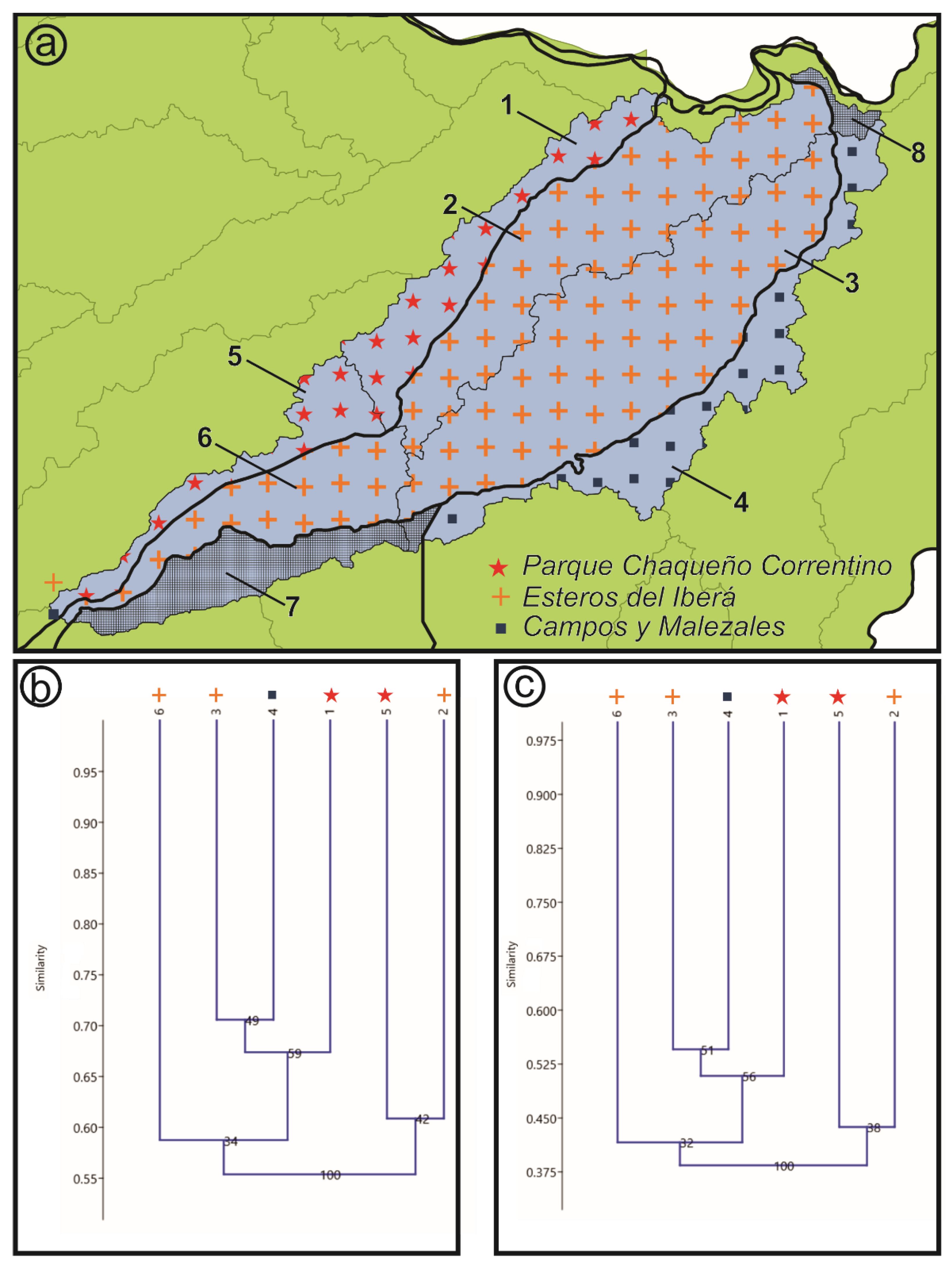
The areas defined by this scheme were not recovered in our cluster analysis, with none of the areas rearranging themselves according to the expected groups (Figure 6b,c).

3.3. Ecoregions

The areas defined by this scheme were also not recovered in our cluster analysis, with none of the areas rearranging themselves according to the expected groups (Figure 7b,c).

3.4. Basins

The analysis between the Iberá Depression and the external basins shows (according to the Jaccard and Sorencen–Dice indexes) two main groups. The Iberá Depression sub-basins show less similarity among them than with the external basins (Figure 8a,b). In this regard, two main clusters were found: Iberá and Carambolas grouped together with Santa Lucía ((9-1)2) and the group conformed by the Batel and Naciente del Río Corriente group (8-3) with Miriñay (10) as a “sister” group of both of them.
The β diversity analysis shows the highest similarity for the cluster Iberá-Santa Lucia (J > 0.5, D > 0.7) and Batel-Naciente del Río Corriente (J > 0.5, D > 0.65). On the other hand, the lowest similarity is shown to be the Aguapey (J < 0.15, D < 0.2), with the rest of the basins.

4. Discussion

The affinities of the biota of Iberá have been discussed several times, based mainly on plant and animal components. Focusing on different arthropods, such as spiders and odonates, previous studies have attempted to validate, without much success, that this wetland system belongs to one of the biogeographical units postulated in previous schemes [7,14]. It has even recently been questioned regarding its nature as an ecoregion unit, postulating an ecotonal character based on a low degree of endemism and the multiple biogeographical units that converge in this region [14].
Since none of the areas established in the biogeographical and ecoregional proposals were recovered by the present results, we confirm that the odonates of Iberá do not follow any of the available regional biota-based schemes. The same can be said about the hydrological scheme, since our results show that the three internal basins of the Iberá Depression show higher similarities with the external basins than with each other.
The odonates, like other continental aquatic taxa, such as fish or rotifers [30,31,32], seem to be refractory to the widespread regionalization schemes, at least in South America. This is probably due to their amphibiotic cycle with a terrestrial phase with great flight capacity (including their ability to perform large migrations), and their role as generalist predators. From a more general perspective, inland aquatic ecosystems seem to support much coarser regionalization schemes than those based on terrestrial biota [22,23,31,32]; perhaps due to the buffering nature of the water and the possibility of physical connectivity between basins due to sporadic flooding.
For odonates, a possible interpretation of the distribution patterns observed in this study, and their mismatch with previous schemes, can be interpreted by looking at habitat types (Figure 2b). The odonate distribution patterns appear to reflect the type of aquatic habitat (lentic or lotic with similar environmental conditions), regardless of the specific composition of the surrounding terrestrial vegetation. In this sense, the two main groupings of areas (9-1-2 and 8-3) may be the result of the habitat typology present within these basins. In the case of the 9-1-2 group, the most predominant type of water mass is wetlands, with few and very small permanent streams. The second group (8-3) presents a mixture of rivers and numerous interconnected streams with numerous wetlands throughout its basin. In the peculiar case of Miriñay (10), its river originates in the Iberá Depression, the basin is characterized by a floodplain with impermeable soil and very little slope that favors the retention of surface water, forming an area of semi-permanent swamps (Figure 9a,b) [33]. According to these results, the main environmental attributes that seem to determine odonate distribution patterns are related to the availability of particular wetlands (e.g., lagoons, streams, rivers, swamps, etc.), or special physical characteristics, such as type of sediment, oxygen availability, etc.
Finally, it is worth mentioning that for any attempt to use widespread distribution patterns to propose or promote actions and/or policies for the conservation of aquatic biota, beyond the broad framework of faunal affinity (e.g., Neotropical or Austral), ecological data should be prioritized over geographic or climatic data, to achieve better results than those schemes based on terrestrial taxa. Those assessments whose objective is the protection or conservation of freshwater biota, such as environmental impact and monitoring, the conservation status of species, etc., must consider their ecological limitations with much more emphasis than their regional biogeographical context.

Supplementary Materials

The following supporting information can be downloaded at: https://www.mdpi.com/article/10.3390/d14100842/s1, Supplementary Data S1: Checklist of Odonata per basin used in this paper. *: new records for the Iberá De-pression compared with Muzón et al. [7]; Supplementary Data S2: List of localities sampled with georeferences.

Author Contributions

Conceptualization, J.M.; methodology, A.d.P., L.S.R. and J.M.; formal analysis, A.d.P.; data curation, A.d.P., F.L. and M.d.l.M.N.; writing—original draft preparation, A.d.P., F.L., L.S.R. and J.M.; writing—review and editing, A.d.P., F.L., L.S.R., J.M. and M.d.l.M.N. All authors have read and agreed to the published version of the manuscript.

Funding

This study was partially funded by CONICET (Consejo Nacional de Investigaciones Científicas y Técnicas, Argentina) and by the National Geographic Society (Grant # 7104-01).

Institutional Review Board Statement

Not applicable.

Data Availability Statement

Data are contained within the article; specimens analyzed in this study are deposited in the Entomological Collection of the Laboratorio de Biología y Genética Ambiental (BioGeA, Universidad Nacional de Avellaneda) and are available on request to the collection managers.

Conflicts of Interest

The authors declare no conflict of interest.

References

  1. Noss, R.F. Indicators for Monitoring Biodiversity: A Hierarchical Approach. Conserv. Biol. 1990, 4, 355–364. [Google Scholar] [CrossRef]
  2. Lehner, B.; Grill, G. Global River Hydrography and Network Routing: Baseline Data and New Approaches to Study the World’s Large River Systems. Hydrol. Process. 2013, 27, 2171–2186. [Google Scholar] [CrossRef]
  3. He, F.; Bremerich, V.; Zarfl, C.; Geldmann, J.; Langhans, S.D.; David, J.N.W.; Darwall, W.; Tockner, K.; Jähnig, S.C. Freshwater Megafauna Diversity: Patterns, Status and Threats. Divers. Distrib. 2018, 24, 1395–1404. [Google Scholar] [CrossRef] [Green Version]
  4. Bailey, R.G. Identifying Ecoregion Boundaries. Environ. Manage. 2004, 34, 14–26. [Google Scholar] [CrossRef] [PubMed]
  5. Lozano, F.; del Palacio, A.; Ramos, L.; Muzón, J. The Odonata of Argentina: State of knowledge and updated checklist. Int. J. Odonatol. 2020, 23, 113–153. [Google Scholar] [CrossRef]
  6. Muzón, J.; Pessacq, P.; Lozano, F. The Odonata (Insecta) of Patagonia: A Synopsis of their current status with illustrated keys for their identification. Zootaxa 2014, 3784, 346–388. [Google Scholar] [CrossRef] [Green Version]
  7. Muzón, J.; Von Ellenrieder, N.; Pessacq, P.; Lozano, F.; Garré, A.; Lambruschini, J.; Ramos, L.; Weigel Muñoz, S. Odonata from Iberá Wetlands (Corrientes, Argentina): Preliminary Inventory and Biodiversity. Rev. Soc. Entomol. Argent. 2008, 67, 59–67. [Google Scholar]
  8. Rubio, G.D.; Moreno, C.E. Orb-Weaving Spider Diversity in the Iberá Marshlands, Argentina. Neotrop. Entomol. 2010, 39, 496–505. [Google Scholar] [CrossRef] [PubMed] [Green Version]
  9. Casciotta, J.R.; Almirón, A.E.; Bechara, J. Peces Del Iberá; Grafikar: La Plata, Argentina, 2005. [Google Scholar]
  10. Calcaterra, L.A.; Cuezzo, F.; Cabrera, S.M.; Briano, J.A. Ground Ant Diversity (Hymenoptera: Formicidae) in the Ibera Nature Reserve, the Largest Wetland of Argentina. Ann. Entomol. Soc. Am. 2010, 103, 71–83. [Google Scholar] [CrossRef]
  11. Coscarón, M.C.; Melo, M.C.; Coddington, J.; Corronca, J. Estimating Biodiversity: A Case Study on True Bugs in Argentinian Wetlands. Biodivers. Conserv. 2009, 18, 1491–1507. [Google Scholar] [CrossRef]
  12. Ingaramo, M.D.R.; Etchepare, E.G.; Álvarez, B.B.; Porcel, E. Riqueza y Composición de la Fauna de Anuros en la Región Oriental de la Reserva Natural Provincial Esteros Del Iberá, Corrientes, Argentina. Rev. Biol. Trop. 2012, 60, 759–769. [Google Scholar] [CrossRef]
  13. Dufek, M.I.; Oscherov, E.B.; Damborsky, M.P. Actualización de La Distribución de Tábanos (Diptera: Tabanidae) En La Reserva Natural Esteros Del Iberá, Argentina. Entomotropica 2016, 31, 36–39. [Google Scholar]
  14. Rubio, G.D.; Nadal, M.F.; Munévar, A.C.; Avalos, G.; Perger, R. Iberá Wetlands: Diversity Hotspot, Valid Ecoregion or Transitional Area? Perspective from a Faunistic Jumping Spiders Revision (Araneae: Salticidae). Species 2018, 19, 117–131. [Google Scholar]
  15. Lozano, F.; del Palacio, A.; Ramos, L.; Granato, L.; Drozd, A.; Muzón, J. Recovery of local dragonfly diversity following restoration of an artificial lake in an urban area near Buenos Aires. Basic Appl. Ecol. 2022, 58, 88–97. [Google Scholar] [CrossRef]
  16. Comunicación del CCT CONICET Incendios En Corrientes: Evaluarán Los Efectos a Mediano Plazo Sobre La Biodiversidad. Available online: https://nordeste.conicet.gov.ar/incendios-efectos-sobre-la-biodiversidad/ (accessed on 20 August 2022).
  17. Cabrera, A.L.; Willink, A. Biogeografía de América Latina; Programa Regional de Desarrollo Científico y Tecnológico, Organización de los Estados Americanos: Washington, DC, USA, 1980. [Google Scholar]
  18. Brown, A.; Pacheco, S. Propuesta de Actualización del Mapa Ecorregional de la Argentina; La situación: Ambient, Argentina, 2005; pp. 28–31. [Google Scholar]
  19. Herbst, R.; Jorge, N.; Cruz, S. Mapa Litoestratigráfico de la Provincia de Corrientes. Inst. Geol. Paleontol. 1985, 2, 1–50. [Google Scholar]
  20. Orfeo, O.; Neiff, J.J. Esteros del Iberá. Un Enorme Laboratorio a Cielo Abierto. Sitios Interés Geológico La República Argent: Argentina. 2008. Available online: http://repositorio.segemar.gov.ar/308849217/1343 (accessed on 1 October 2022).
  21. Secretaria de Recursos Hídricos. Atlas de Cuencas y Regiones Hídricas Superficiales de la República Argentina; 2010. Available online: https://www.argentina.gob.ar/obras-publicas/hidricas/cartografia-hidrica-provincial (accessed on 1 October 2022).
  22. Morrone, J.J.; Escalante, T.; Rodríguez-Tapia, G.; Carmona, A.; Arana, M.; Mercado-Gómez, J.D. Biogeographic regionalization of theNeotropical region: New map and shapefile. Ann. Acad. Bras. Cienc. 2022, 94, e20211167. [Google Scholar] [CrossRef]
  23. Apodaca, M.J.; Katinas, L.; Guerrero, E.L. Hidden areas of endemism: Small units in the South-eastern Neotropics. Syst. Biodivers. 2019, 17, 425–438. [Google Scholar] [CrossRef]
  24. Ribichich, A.M. El modelo clásico de la Fitogeografía de Argentina: UN Análisis Crítico. Interciencia 2002, 27, 669–675. [Google Scholar]
  25. Hammer, Ø.; Harper, D.A.T.; Ryan, P.D. PAST: Paleontological Statistics Software Package for Education and Data Analysis. Palaeontol. Electron. 2001, 4, 1–9. [Google Scholar]
  26. Cardoso, P.; Borges, P.A.; Veech, J.A. Testing the performance of beta diversity measures based on incidence data: The robustness to undersampling. Divers. Distrib. 2009, 15, 1081–1090. [Google Scholar] [CrossRef] [Green Version]
  27. Singh, W. Robustness of three hierarchical agglomerative clustering techniques for Ecological Data. Master’s Thesis, University of Iceland, Reykjavík, Iceland, 2008; p. 100. [Google Scholar]
  28. Legendre, P.; Legendre, L. Numerical Ecology; Elsevier: Amsterdam, The Netherlands, 1998; Volume 40, ISBN 0444892508. [Google Scholar]
  29. QGIS Development Team. QGIS Geographic Information System. Open Source Geospat. Found. Proj. 2022. Available online: http://qgis.osgeo.org (accessed on 1 August 2022).
  30. López, H.L.; Menni, R.C.; Donato, M.; Miquelarena, A.M. Biogeographical Revision of Argentina (Andean and Neotropical Regions): An analysis using freshwater fishes. J. Biogeogr. 2008, 35, 1564–1579. [Google Scholar] [CrossRef]
  31. Ringuelet, R.A. Zoogeografía y Ecología de los Peces de Aguas Continentales de la Argentina y consideraciones sobre las áreas ictiológicas de América del Sur. Ecosur 1975, 2, 1–122. [Google Scholar]
  32. José de Paggi, S. Ecological and biogeographical remarks on the Rotifer Fauna of Argentina. Inst. Nac. Limnol. 1990, 23, 297–311. [Google Scholar]
  33. Martínez, S.J. Cuenca del Río Miriñay. Available online: https://www.argentina.gob.ar/sites/default/files/43.pdf (accessed on 15 August 2022).
Figure 1. (a) Map of Argentina showing the Iberá Depression in the Corrientes province. (b) Photo of a typical wetland of the Iberá Depression (San Nicolás, Corrientes), (c) Photo of Laguna Iberá (Corrientes), (d) Photo of a typical wetland of Pay Ubre (Corrientes), (e) Photo of a typical wetland within Mburucuyá (Corrientes). CO: Corrientes province, MIS: Misiones province.
Diversity 14 00842 g001
Figure 2. (a) Iberá Depression showing its sub-basins: 1: Carambolas, 2: Iberá, and 3: Naciente del Río Corriente, (b) Different types of wetlands within Corrientes province.
Diversity 14 00842 g002
Figure 3. (a) Esteros del Iberá province sensu Morrone et al. [22], (b) Esteros del Iberá ecoregion sensu Brown and Pacheco [18]: 1: Parque Chaqueño Correntino; 2: Iberá.
Diversity 14 00842 g003
Figure 4. (a) Biogeographic provinces sensu Cabrera and Willink [17], (b) Map showing the Iberá Depression and surrounding hydrological basins, the selected basins in this study are numbered and highlighted in color.
Diversity 14 00842 g004
Figure 5. Localities sampled (see Supplementary Data S2 for georeferences).
Diversity 14 00842 g005
Figure 6. (a) Iberá Depression divided by the biogeographic provinces, (b) Dendrogram showing similarity between areas (Sorensen–Dice), (c) Dendrogram showing similarity between areas (Jaccard). The dendrograms showed a cophenetic correlation (CC) > 0.96.
Diversity 14 00842 g006
Figure 7. (a) Iberá Depression divided by the ecoregions, (b) Dendrogram showing similarity between areas (Sorensen–Dice), (c) Dendrogram showing similarity between areas (Jaccard). The dendrograms showed a CC > 0.96.
Diversity 14 00842 g007
Figure 8. (a) Dendrogram showing similarity between hydrological basins (Sorensen–Dice), CC > 0.96, (b) Dendrogram showing similarity between hydrological basins (Jaccard), CC > 0.96.
Diversity 14 00842 g008
Figure 9. (a) Map of Iberá depression and external basins groups with lotic and lentic systems, (b) Groups of basins according to the results.
Diversity 14 00842 g009
Publisher’s Note: MDPI stays neutral with regard to jurisdictional claims in published maps and institutional affiliations.

