Proceeding Paper

The Challenge of Wildlife Conservation from Its Biogeographical Distribution Perspectives, with Implications for Integrated Management in Peru †

by
Alexander Cotrina Sánchez
1,2,*,
Gerson Meza Mori
1,
Subhajit Bandopadhyay
3,
Carlos Oviedo
4,
Nilton B. Rojas Briceño
1,
Manuel Oliva
1,
Ligia García
1 and
Cristóbal Torres Guzmán
1
1
Instituto de Investigación para el Desarrollo Sustentable de Ceja de Selva (INDES-CES) de la, Universidad Nacional Toribio Rodríguez de Mendoza de Amazonas, Chachapoyas 01001, Peru
2
Department for Innovation in Biological, Agri-Food and Forest Systems, Università degli Studi della Tuscia, Via San Camillo de Lellis, 4, 01100 Viterbo, Italy
3
School of Geography and Environmental Science, University of Southampton, Southampton SO17 1BJ, UK
4
Grupo de Investigación Ambiente y Vida (GIAV), Universidad Francisco de Paula Santander, San José de Cúcuta 540003, Colombia
*
Author to whom correspondence should be addressed.
Presented at the 2nd International Electronic Conference on Diversity (IECD 2022)—New Insights into the Biodiversity of Plants, Animals and Microbes, 15–31 March 2022; Available online: https://sciforum.net/event/IECD2022.
Biol. Life Sci. Forum 2022, 15(1), 10; https://doi.org/10.3390/IECD2022-12436
Published: 17 March 2022

Abstract

:
Biodiversity is an indispensable resource and contributes to the balance of ecosystems, being of great importance for the development of a society and its culture through good management of natural spaces. However, the reduction in and fragmentation of habitats, trafficking, and illegal trade in wild animals affect the great diversity of wild flora and fauna that characterize Peru. Considering this problem, we modeled the biogeographic distribution of five species of wildlife categorized as threatened by Peruvian legislation and included in the red list of threatened species of the International Union for the Conservation of Nature (IUCN): critically endangered (CR) Lagothrix flavicauda, endangered (EN) Aotus miconax, in vulnerable-status (VU) Tremarctos ornatus and Lagothrix cana, and in the near-threatened category (NT) Panthera onca. Our study aimed to identify their current potential distribution in the Peruvian territory which is legally protected by the conservation areas of national, regional, or private administration. In this regard, we used a maximum-entropy approach (MaxEnt), integrating 14 variables (7 bioclimatic variables, 3 topographic, 3 variables of vegetation cover, and relative humidity). It was observed that 3.6% (46,225.50 km2) of the Peruvian territory presented a high probability (>0.6) of distribution of the evaluated species and 10.7% (136,918.28 km2) of moderate distribution (0.4–0.6). Based on this, our study allowed us to identify the geographical spaces for threatened species on which conservation actions should focus, through the formulation of strategies, plans, policies, and participatory management in the Peruvian territory.

1. Introduction

Peru is one of the 17 megadiverse countries in the world [1,2,3], and to preserve this biodiversity in recent decades, national, regional, and private conservation areas have been created, with the aim of conserving species of high diversity and endemism, marine biodiversity, or particular groups of organisms [4,5,6]. However, over time, anthropic pressures, such as deforestation, installation of agricultural crops, extensive livestock, illegal mining, and forest fires, among others, have reduced the habitat of native and endemic species, which has led to the reduction in their populations [7]. Based on this, Peruvian legislation [8] and the International Union for Conservation of Nature (IUCN) red list of threatened species of wildlife have categorized the species in our study as described: critically endangered (CR) Lagothrix flavicauda, endangered (EN) Aotus miconax, vulnerable-status (VU) Tremarctos ornatus and Lagothrix cana, and near-threatened category (NT) Panthera once [9]. This situation describes the importance of knowing the territorial spaces in which to manage and implement plans for the survival of local populations, mitigating poaching and illegal trade [7,10].
The species considered in this study have been identified as those requiring urgent conservation measures by the International Union for Conservation of Nature, the Convention on International Trade in Endangered Species, and the International Primatological Society, in addition to being protected by the Peruvian legislation [11]. However, the National Service of Natural Areas Protected by the State reports only 22,645,810.51 hectares of protected natural areas for conservation, equivalent to only 17.62% of the Peruvian territory [6]. In addition, the nature protection offices in the country work with extremely small budgets [11]; therefore, it is crucial to develop international, strategic alliances for habitat conservation.
Therefore, species distribution models (SDM) are important tools in conservation approaches [12], allowing the identification of geographical spaces with similar topographic characteristics, bioclimatic features, and records of presence [13]. SDMs have been widely applied in the identification of potential wildlife distribution in large mammals [14] and flora species, the prediction of deforestation and forest fires [15,16,17,18], as well as the assessment of the impact of anthropogenic land-use change in protected areas [19]. The maximum-entropy algorithm (MaxEnt) is the one that presents reliable, optimal, and defensible results and surpasses other SDM algorithms [13,20,21,22]. In this study, using MaxEnt, we identified the biographical distribution under current conditions for an integrated management of the wild fauna of the species L. flavicauda, A. miconax, T. ornatus, L. cana, and P. onca in the Peruvian territory.

2. Study Area

This study is located between the parallels 0°03′00′’ and 18°30′00” south and the meridians 68°30′00” and 81°30′00′’ to the west, covering the Peruvian territory, in an area of approx. 1,300,000 km2, with a rugged area consisting of geographical regions of coast, mountains, and jungle and altitudinal gradients from 0 m to 6800 m above sea level (m.a.s.l) (Figure 1).

3. Material and Methods

3.1. Datase

The presence data of the species were obtained from the register of CITES species by the Ministry of the Environment of Peru—MINAM [23], in combination with spatial information from the Global Biodiversity Information Service—GBIF [24] and “Species Explorer”, collected through the noncommercial software QGIS. The data were exported in a comma-delimited format (.csv) for integration into the maximum-entropy (MaxEnt) software ver. 3.4.1 [25]. To perform the spatial modeling of the species, initially, 28 variables were included (Table S1) and rescaled to a spatial resolution of 250 m. Likewise, in order to minimize the multiple multicollinearities of these variables, they were filtered using the Pearson correlation coefficient through the R 3.6 software (The R Foundation, Vienna, Austria) and r = ±0.8 was established as the cut-off value for the highly correlated variables [26,27,28]. Finally, the 14 variables (Table 1) were chosen for the final modeling: 7 bioclimatic variables were included, in addition to relative humidity from WorlClim [29] and 3 topographic variables derived from the digital elevation model (DEM), available on the United States Geological Survey (USGS) portal [30]. The variables of vegetation cover of ecosystems were from the MINAM study [23,31], tree altitude [32] and land use/land cover (LULC) [33].

3.2. Methods

Figure 2 summarizes the methodological design of our research; based on the spatial standardization of cartographic variables and their trimming at the level of the Peruvian territory, the biogeographic modeling of the 05 species was carried out using the MaxEnt software [25,34]. We used 75% of the presence data for training and 25% for validation [34], using 5000 iterations and 10 replicas with random partitions (cross-validation method); other settings were maintained by default. The validation of the models was carried out according to the area under the curve (AUC) and differentiated performance in five levels: invalid (<0.6), bad (0.6–0.7), accepted (0.7–0.8), good (0.8–0.9), and excellent (>0.9) [34,35,36]; in the same way, the contribution of each of the variables in the model was obtained. Finally, the resulting raster of distribution was reclassified into four potential habitat ranges (“high”, >0.6; “moderate”, 0.4–0.6; “low”, 0.2–0.4; and “non-potential”, <0.2) [15,16,17,37] and converted to vector cartographic data to perform the surface calculation.

4. Result and Discussion
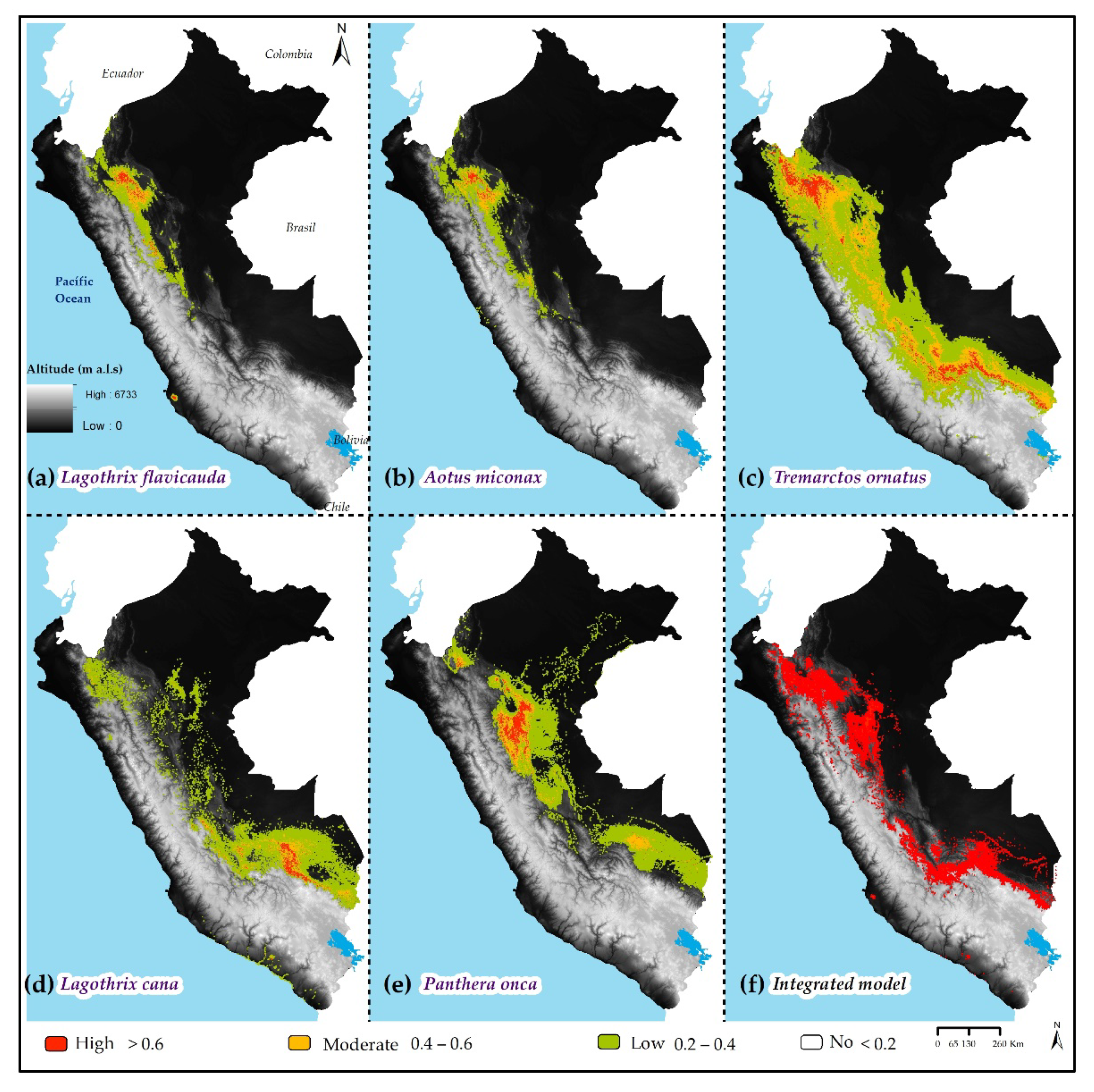
4.1. Results

It was observed that, from integrating the high potential individual distribution of the 05 species (L. flavicauda, A. miconax, T. ornatus, L. cana, and P. onca), 3.6% (46,225.50 km2) of the Peruvian territory presented a high probability of distribution (>0.6) and 10.7% (136,918.28 km2) a moderate distribution (0.4–0.6) (Figure 3f). Correspondingly, L. flavicauda had a high potential distribution of 3354.74 km2 (Figure 3a) and A. miconax had a high distribution of 2,324.96 km2 (Figure 3b). T. ornatus presented the largest area of high potential distribution in 23,179.96 km2 (Figure 3c); finally, the high potential distribution of L. cana covers 5833.33 km2 (Figure 3d) and 11,532.50 km2 for P. onca, respectively (Figure 3e).
Modeling showed an average performance of AUC = 0.97, considered excellent (AUC > 0.9). Likewise, the bioclimatic variables with the greatest contribution to modeling were the precipitation of the driest month (Bio14) and relative humidity (rhm); in the same way, the variables such as altitude (DEM), type of ecosystem (ecosystem), and slope (slope) had a high contribution in the modeling of each species (Figure 4).

4.2. Discussion

SDMs are a statistical tool [38] widely used in studies of rare and endangered groups, as well as the environmental variables that affect them [39]. SDMs have contributed significantly to the challenge of wildlife conservation from a biogeographical approach [40,41,42,43,44,45]. Our study is the first to integrate the high potential individual distribution of 05 species of threatened wildlife—in critically endangered condition (L. flavicauda),” endangered (A. miconax), vulnerable (T. ornatus and L. cana) and near-threatened (P. onca)—within the Peruvian territory. The model required strong performance values of AUC = 0.97 [45,46]. Of the 14 integrated variables, the precipitation of the driest month (Bio14) and relative humidity (rhm) were the most representative to predict integrated areas for the five species, according to the potential habitat ranges; however, the topographic variables (altitude), the type of ecosystem (ecosystem), and the slope (slope), that also contributed significantly during the modeling, were not dismissed. Our study validates the restricted range of endemic species (L. miconax and L. Favicauda) [7]; it is necessary to indicate that it is possible to find P. onca in other territories of native communities in the Peruvian Amazon, in which recent studies are documenting and reporting it [47]. Thus, it is necessary to carry out subsequent studies to improve the performance of the model with a greater amount of presence data and other variables; this will allow identifying territories’ suitable conservation methods, avoiding the reduction in their population by hunting and habitat loss, as is happening with L. cana [7]. The different methods used to select the variables and, therefore, the different variables introduced in the models, contributed to differentiating their contribution [45,48].
Thus, from the identification of potential areas, it is possible to establish measures to mitigate the reduction and fragmentation of the habitats of these five species, in the Peruvian territory [45]. So, 46,225.50 km2 of the territory is within the 33 geographical spaces suggested in this study, for the threatened species on which conservation actions should be focused [49], through the formulation of strategies, plans, policies, and participatory management in the Peruvian territory. New studies will allow the evaluation of the distribution in future conditions of climate change, in an integrated way, for these five species, as long as this is carried out considering the qualities of the species to adapt to new conditions of persistence and survival [44]. Finally, modeling will allow having a support for the adequate management of the territory to ensure the survival of the species.

5. Conclusions

Modeling through maximum entropy (MaxEnt) obtained a performance considered excellent, with an area under the curve (AUC) of 0.97. From this, under the current conditions, the biogeographic distribution of the 05 species (L. flavicauda, A. miconax, T. ornatus, L. cana, and P. onca) covers 3.6% (46,225.50 km2) of the Peruvian territory; this area presents a high probability of distribution. Added to this, 136,918.28 km2 (10.7%) was identified with a moderate probability of distribution. Finally, the bioclimatic variables with the greatest contribution to modeling are the precipitation of the driest month (Bio14) and relative humidity (rhm), as well as the topographic variables (altitude), the type of ecosystem (ecosystem) and the slope (slope), which contributed significantly during the modeling.

Supplementary Materials

The following supporting information can be downloaded at: https://www.mdpi.com/article/10.3390/IECD2022-12436/s1, Table S1: Initial variables for MaxEnt modeling of Red List of Threatened Species in Peru.

Author Contributions

Conceptualization, A.C.S., N.B.R.B., G.M.M. and L.G.; methodology, A.C.S., N.B.R.B., S.B., C.O., C.T.G., L.G. and G.M.M.; formal analysis, S.B. and L.G.; funding acquisition, C.T.G. and M.O.; investigation, A.C.S., G.M.M., S.B., N.B.R.B., M.O., L.G. and C.O.; project administration, C.T.G. and M.O.; resources, C.T.G. and M.O.; software, A.C.S. and G.M.M.; supervision, A.C.S., S.B. and L.G.; validation, A.C.S., N.B.R.B., G.M.M., M.O., C.O. and L.G.; writing—original draft preparation, A.C.S., G.M.M., L.G. and S.B.; writing—review and editing, A.C.S., S.B., L.G. and N.B.R.B. All authors have read and agreed to the published version of the manuscript.

Funding

This work was supported by the CUI project Nº 2261386 “Service Creation Project of the Biodiversity and Conservation of Wild Species Genetic Resources Laboratory at the Toribio Rodríguez de Mendoza National University—Amazonas Region”.

Institutional Review Board Statement

Not applicable.

Informed Consent Statement

Not applicable.

Data Availability Statement

The data used to support the findings of this study are available from the corresponding author upon request.

Acknowledgments

The authors appreciate and acknowledge the support of the Research Institute for the Sustainable Development of the Eyebrow of the Jungle (INDES-CES) of the National University Toribio Rodriguez de Amazonas (UNTRM). A.C.S was supported by the Highlander Project.

Conflicts of Interest

The authors declare no conflict of interest.

References

  1. Miranda, J.J.; Corral, L.; Blackman, A.; Asner, G.; Lima, E. Effects of Protected Areas on Forest Cover Change and Local Communities: Evidence from the Peruvian Amazon. World Dev. 2016, 78, 288–307. [Google Scholar] [CrossRef] [Green Version]
  2. MINAM. Estrategia Nacional de Diversidad Biológica al 2021 (Plan de Acción 2014–2018); MINAM: Lima, Perú, 2014. [Google Scholar]
  3. UNEP WCMC. Megadiverse Countries definition|Biodiversity A-Z. Available online: http://www.biodiversitya-z.org/content/megadiverse-countries (accessed on 14 September 2021).
  4. Rodriguez, L.O.; Young, K.R. Biological diversity of Peru: Determining priority areas for conservation. Ambio 2000, 29, 329–337. [Google Scholar] [CrossRef]
  5. MINAM. Áreas Naturales Protegidas Del Perú (2011–2015)—Conservación para el Desarrollo Sostenible; MINAM: Lima, Perú, 2016; Volume 1. [Google Scholar]
  6. SERNANP. Listado Oficial de Áreas Naturales Protegidas; SERNANP: Lima, Perú, 2020. [Google Scholar]
  7. SERFOR. Libro Rojo de la Fauna Silvestre Amenazada del Peru; Primera ed.; SERFOR: Lima, Perú, 2018; ISBN 9786124690822. [Google Scholar]
  8. MINAGRI. Decreto Supremo N° 004-2014-MINAGRI: Aprueba la Actualización de la Lista de Clasificación y Categorización de las Especies Amenazadas de Fauna Silvestre Legalmente Protegidas; MINAGRI: Kigali, Rwanda, 2014; pp. 520497–520504. [Google Scholar]
  9. IUCN. The IUCN Red List of Threatened Species. Version 2021-3. Available online: https://www.iucnredlist.org (accessed on 18 August 2021).
  10. SERFOR. Plan Nacional Para la Conservación del oso Andino (Tremarctos Ornatus) en el Perú: Periodo 2016–2026; SERFOR: Lima, Perú, 2016. [Google Scholar]
  11. Shanee, N. Trends in local wildlife hunting, trade and control in the tropical andes biodiversity hotspot, northeastern Peru. Endanger. Species Res. 2012, 19, 177–186. [Google Scholar] [CrossRef] [Green Version]
  12. Urbina-Cardona, J.N.; Flores-Villela, O. Ecological-niche modeling and prioritization of conservation-area networks for Mexican herpetofauna. Conserv. Biol. 2010, 24, 1031–1041. [Google Scholar] [CrossRef] [PubMed]
  13. Elith, J.; Graham, C.H.; Anderson, R.P.; Dudík, M.; Ferrier, S.; Guisan, A.; Hijmans, R.J.; Huettmann, F.; Leathwick, J.R.; Lehmann, A.; et al. Novel methods improve prediction of species’ distributions from occurrence data. Ecography 2006, 29, 129–151. [Google Scholar] [CrossRef] [Green Version]
  14. Saito, M.U.; Momose, H.; Inoue, S. International Journal of Geographical Range-expanding wildlife: Modelling the distribution of large mammals in Japan, with management implications. Int. J. Geogr. Inf. Sci. 2014, 30, 20–35. [Google Scholar] [CrossRef]
  15. Rojas, N.B.; Cotrina, D.A.; Castillo, E.B.; Oliva, M.; Salas, R. Current and Future Distribution of Five Timber Forest Species in Amazonas, Northeast Peru: Contributions towards a Restoration Strategy. Diversity 2020, 12, 21. [Google Scholar] [CrossRef]
  16. Cotrina Sánchez, A.; Bandopadhyay, S.; Rojas Briceño, N.B.; Banerjee, P.; Torres Guzmán, C.; Oliva, M. Peruvian Amazon disappearing: Transformation of protected areas during the last two decades (2001–2019) and potential future deforestation modelling using cloud computing and MaxEnt approach. J. Nat. Conserv. 2021, 64, 126081. [Google Scholar] [CrossRef]
  17. Cotrina, D.A.; Castillo, E.; Rojas, N.B.; Oliva, M.; Guzman, C.T.; Amasifuen, C.A.; Bandopadhyay, S. Distribution models of timber species for forest conservation and restoration in the Andean-Amazonian landscape, North of Peru. Sustainability 2020, 12, 7945. [Google Scholar] [CrossRef]
  18. Fonseca, M.; Alves, L.; Aguiar, A.P.; Tejada, G.; Arai, E.; Anderson, L.; Shimabukuro, Y.E.; Aragão, L. Modelling future fire probability in the Brazilian Amazon under different land-use and climate change scenarios. Glob. Chang. Biol. 2019, 19, 2017–10335. [Google Scholar]
  19. Thonfeld, F.; Steinbach, S.; Muro, J.; Hentze, K.; Games, I.; Näschen, K.; Kauzeni, P.F. The impact of anthropogenic land use change on the protected areas of the Kilombero catchment, Tanzania. ISPRS J. Photogramm. Remote Sens. 2020, 168, 41–55. [Google Scholar] [CrossRef]
  20. Pearson, R.G.; Raxworthy, C.J.; Nakamura, M.; Peterson, A.T. Predicting species distributions from small numbers of occurrence records: A test case using cryptic geckos in Madagascar. J. Biogeogr. 2007, 34, 102–117. [Google Scholar] [CrossRef]
  21. Wisz, M.S.; Hijmans, R.J.; Li, J.; Peterson, A.T.; Graham, C.H.; Guisan, A.; Elith, J.; Dudík, M.; Ferrier, S.; Huettmann, F.; et al. Effects of sample size on the performance of species distribution models. Divers. Distrib. 2008, 14, 763–773. [Google Scholar] [CrossRef]
  22. Nazeri, M.; Jusoff, K.; Madani, N.; Mahmud, A.R.; Bahman, A.R.; Kumar, L. Predictive Modeling and Mapping of Malayan Sun Bear (Helarctos malayanus) Distribution Using Maximum Entropy. PLoS ONE 2012, 7, e48104. [Google Scholar] [CrossRef] [Green Version]
  23. MINAM. Intercambio de Datos–Geoservidor. Available online: https://geoservidor.minam.gob.pe/recursos/intercambio-de-datos/ (accessed on 30 August 2021).
  24. GBIF Global Biodiversity Information Facility. Available online: https://www.gbif.org/species/search (accessed on 30 August 2021).
  25. Phillips, S.J.; Dudik, M.; Schapire, R.E. Software Maxent Para Modelar Nichos y Distribuciones de Especies (Versión 3.4.1). Available online: https://biodiversityinformatics.amnh.org/open_source/maxent/ (accessed on 15 August 2021).
  26. Xu, N.; Meng, F.; Zhou, G.; Li, Y.; Wang, B.; Lu, H. Assessing the suitable cultivation areas for Scutellaria baicalensis in China using the Maxent model and multiple linear regression. Biochem. Syst. Ecol. 2020, 90, 104052. [Google Scholar] [CrossRef]
  27. Yang, X.Q.; Kushwaha, S.P.S.; Saran, S.; Xu, J.; Roy, P.S. Maxent modeling for predicting the potential distribution of medicinal plant, Justicia adhatoda L. in Lesser Himalayan foothills. Ecol. Eng. 2013, 51, 83–87. [Google Scholar] [CrossRef]
  28. Remya, K.; Ramachandran, A.; Jayakumar, S. Predicting the current and future suitable habitat distribution of Myristica dactyloides Gaertn. using MaxEnt model in the Eastern Ghats, India. Ecol. Eng. 2015, 82, 184–188. [Google Scholar] [CrossRef]
  29. Fick, S.E.; Hijmans, R.J. WorldClim 2: New 1 km spatial resolution climate surfaces for global land areas. Int. J. Climatol. 2017, 37, 4302–4315. [Google Scholar] [CrossRef]
  30. USGS. U.S. Geological Survey (USGS). Available online: https://earthexplorer.usgs.gov/ (accessed on 20 August 2021).
  31. MINAM. Mapa Nacional de Ecosistemas del Perú; MINAM: Lima, Perú, 2018. [Google Scholar]
  32. Potapov, P.; Li, X.; Hernandez-Serna, A.; Tyukavina, A.; Hansen, M.C.; Kommareddy, A.; Pickens, A.; Turubanova, S.; Tang, H.; Silva, C.E.; et al. Mapping global forest canopy height through integration of GEDI and Landsat data. Remote Sens. Environ. 2021, 253, 112165. [Google Scholar] [CrossRef]
  33. Karra, K.; Kontgis, C.; Statman-Weil, Z.; Mazzariello, J.C.; Mathis, M.; Brumby, S.P. Global land use/land cover with Sentinel 2 and deep learning. In Proceedings of the 2021 IEEE International Geoscience and Remote Sensing Symposium IGARSS, Brussels, Belgium, 11–16 July 2021; pp. 4704–4707. [Google Scholar]
  34. Phillips, S.B.; Aneja, V.P.; Kang, D.; Arya, S.P. Maximum entropy modeling of species geographic distributions. Proc. Int. J. Glob. Environ. 2006, 6, 231–252. [Google Scholar] [CrossRef] [Green Version]
  35. Manel, S.; Williams, C.; Ormerod, S.J. Evaluating presence—Absence models in ecology: The need to account for prevalence. J. Appl. Ecol. 2001, 38, 921–931. [Google Scholar] [CrossRef]
  36. Hanley, J.A.; McNeil, B.J. The Meaning and Use of the Area under a Receiver Operating Characteristic (ROC) Curve1. Radiology 1982, 143, 29–36. [Google Scholar] [CrossRef] [PubMed] [Green Version]
  37. Zhang, K.; Zhang, Y.; Tao, J. Predicting the potential distribution of Paeonia veitchii (Paeoniaceae) in China by incorporating climate change into a maxent model. Forests 2019, 10, 190. [Google Scholar] [CrossRef] [Green Version]
  38. Ryo, M.; Angelov, B.; Mammola, S.; Kass, J.M.; Benito, B.M.; Hartig, F.; Ryo, M. Explainable artificial intelligence enhances the ecological interpretability of black-box species distribution models. Ecography 2021, 44, 199–205. [Google Scholar] [CrossRef]
  39. Benito, B.M.; Martínez-Ortega, M.M.; Muñoz, L.M.; Lorite, J.; Peñas, J. Assessing extinction-risk of endangered plants using species distribution models: A case study of habitat depletion caused by the spread of greenhouses. Biodivers. Conserv. 2009, 18, 2509–2520. [Google Scholar] [CrossRef]
  40. Shanee, S.; Shanee, N.; Campbell, N.; Allgas, N. Biogeography and conservation of Andean primates in Peru. In High Altitude Primates; Springer: New York, NY, USA, 2014; pp. 63–83. ISBN 9781461481751. [Google Scholar]
  41. Shanee, S. Distribution Survey and Threat Assessment of the Yellow-tailed Woolly Monkey (Oreonax flavicauda; Humboldt 1812), Northeastern Peru. Int. J. Primatol. 2011, 32, 691–707. [Google Scholar] [CrossRef]
  42. Campbell, N.; Anna, K.; Nekaris, I.; Pereira, T.S.; Allgas, N.; Shanee, S. Occupancy Modeling for the Conservation Assessment of the Peruvian Night Monkey (Aotus miconax). Primate Conserv. 2019, 33, 13–20. [Google Scholar]
  43. Aquino, R.; López, L.; Falcón, R.; Diaz, S.; Galvez, H. First Inventory of Primates in the Montane Forests of the Pasco and Ucayali Regions, Peruvian Amazon. Primate Conserv. 2019, 33, 1–11. [Google Scholar]
  44. Jędrzejewski, W.; Robinson, H.S.; Abarca, M.; Zeller, K.A.; Velasquez, G.; Paemelaere, E.A.D.; Goldberg, J.F.; Payan, E.; Hoogesteijn, R.; Boede, E.O.; et al. Estimating large carnivore populations at global scale based on spatial predictions of density and distribution—Application to the jaguar (Panthera onca). PLoS ONE 2018, 13, e0194719. [Google Scholar] [CrossRef]
  45. Meza, G.; Castillo, E.B.; Guzmán, C.T.; Cotrina, D.A.; Guzman, B.K.; Oliva, M.; Bandopadhyay, S.; Salas, R.; Rojas, N.B. Predictive modelling of current and future potential distribution of the spectacled bear (Tremarctos ornatus) in Amazonas, northeast Peru. Animals 2020, 10, 1816. [Google Scholar] [CrossRef]
  46. Araujo, M.; Pearson, R.; Thuiller, W.; Erhard, M. Validation of species-climate impact models under climate change. Glob. Chang. Biol. 2005, 11, 1504–1513. [Google Scholar] [CrossRef] [Green Version]
  47. Scullion, J.; Cueto, L.E.; Huaytalla, V. A New Case of Melanic Jaguar, Panthera Onca (Carnivora: Felidae) From Peru. Folia Amaz. 2019, 28, 249–254. [Google Scholar]
  48. Duan, R.-Y.; Kong, X.-Q.; Huang, M.-Y.; Fan, W.-Y.; Wang, Z.-G. The Predictive Performance and Stability of Six Species Distribution Models. PLoS ONE 2014, 9, e112764. [Google Scholar] [CrossRef] [Green Version]
  49. Beezley, W.; Berry, M.K.; Carey, M.; Carruthers, J.; Drummond, J.A.; Leal, C.; Miller, N.; Pochop, K.; Puente, J.; Ragas, J.; et al. Saving the Vicuña: The Political, Biophysical, and Cultural History of Wild Animal Conservation in Peru; Oxford University Press: Oxford, UK, 2020. [Google Scholar]
Figure 1. Study area and species presence data.
Blsf 15 00010 g001
Figure 2. Methodological design.
Blsf 15 00010 g002
Figure 3. Biogeographic distribution of Red List of Threatened Species.
Blsf 15 00010 g003
Figure 4. Percentage of contribution of variables in MaxEnt modeling.
Blsf 15 00010 g004
Table 1. Bioclimatic, topographic, and vegetation cover variables used in modelling.
VariableUnitsSymbol
BioclimaticAnnual mean temperature°Cbio01
Min. temperature of coldest month°Cbio06
Mean temperature of warmest quarter°Cbio10
Precipitation of driest monthmmbio14
Precipitation seasonalitymmbio15
Precipitation of wettest quartermmbio16
Precipitation of coldest quartermmbio19
Relative humidity%rhm
TopographicElevation above mean sea levelm.a.s.ldem
Slope of the terrain°slope
Distance to hydrographymd_water
Vegetation coverEcosystemTypeEcosystem
Tree heightmTree_h
Land use and land coverTypeLULC
Publisher’s Note: MDPI stays neutral with regard to jurisdictional claims in published maps and institutional affiliations.

