1. Introduction
The proper identification of suitable landfill sites is a critical concern driven by the growing global population and urban expansion [
1], leading to increased volumes of municipal solid waste (MSW) [
2]. Annually, the global population generates an estimated ten billion tons of solid waste encompassing residential, commercial, industrial, and construction waste. Within this, approximately 20% consists of MSW, a quantity that scales with population growth. Within Brazil, the largest economy in Latin America, almost 60% of the collected MSW is appropriately disposed of in landfills. Nonetheless, the remaining 40% is inappropriately discarded, amounting for 30.3 million tons of MSW being deposited in open dumps or unregulated landfills lacking essential systems and measures to safeguard public health and the environment from adverse effects and degradation [
3].
Employing systematic methods for site selection is imperative to mitigate environmental challenges such as soil and water contamination [
4,
5], address social complexities like the ‘not in my backyard’ (NIMBY) syndrome [
6,
7], and consider economic factors associated with landfill feasibility [
8,
9]. Nonetheless, identifying suitable landfill locations is intricate due to the multitude of factors requiring consideration [
1]. To enhance accuracy and efficiency, numerous scholars have employed Geographic Information System (GIS)-based multi-criteria decision-making techniques to address this complexity [
10,
11,
12,
13,
14].
Given GIS’s notable efficacy in site selection and the multifaceted nature of decision-making criteria, the amalgamation of GIS and the Analytical Hierarchy Process (AHP) has emerged as a potent approach in landfill site selection endeavors. For instance, GIS and AHP have been employed to identify suitable regions in Northern Cyprus [
15], to pinpoint appropriate areas in the Polog Region, in Macedonia [
16]. Similarly, and to delineate fitting sites in Qom city, Iran [
17], GIS has proven to be a practical tool for conducting landfill site selection studies.
This current study endeavors to propose a multiple-criteria decision analysis (MCDA) framework utilizing a hierarchical analytical process within a GIS computational environment, combined with a FIS. This approach is applied to provide data-driven recommendations for landfill monitoring and assessment. The usage of FIS-based artificial intelligence (AI) in the integrated analysis phase was driven by its capacity to handle the inherent uncertainties associated with data from diverse sources, including indirect remote sensing measurements, and the complex and multifaceted nature of landfill suitability assessment. The proposed framework is then demonstrated through a comprehensive case study designed to assess and classify regions within the São Paulo state in terms of their suitability as potential sites for sanitary landfills.
This paper is organized into four primary sections. The ‘Related Works’ section examines the existing research to establish the contextual foundation for this study. The following section presents the development of the MCDA framework. The ‘Application of the GIS-based MCDA’ section showcases the model’s validation through a case study, demonstrating its practical applicability and effectiveness in addressing Landfill Site Selection challenges. Lastly, the ‘Conclusion’ section summarizes the study’s findings and outlines future directions.
2. Related Works
The increasing utilization of GIS spans diverse domains, including utilities, commerce, governmental applications, and urban planning. The role of GIS in urban planning, as showcased in this study, is particularly noteworthy.
Studies focusing on the selection of suitable sites for sanitary landfills using Multi-Criteria Decision Processes have been widespread. For instance, Alves et al. [
18] assessed the compliance of an existing landfill with legal criteria, providing valuable insights into site selection.
Several studies [
19,
20,
21] employed fuzzy methodologies to achieve their objectives, illustrating the versatility of GIS. The AHP has been a prevalent choice, as evidenced by Alkaradaghi et al. [
22] and Aksoy and San [
23], who applied it to landfill site selection with robust results. The consistency of this method across studies underscores its reliability. This study stands out due to its extensive study area and the comprehensive comparison of criteria across environmental, social, and economic dimensions. A similar large-scale study was conducted by Nascimento et al. [
24] in California.
In the Brazilian context, comprehensive studies within the São Paulo State study area remain limited. Nascimento and Silva [
25] highlighted challenges in finding suitable landfill locations in Bauru, a city in the interior of the State. In a broader context, Senkiio et al. [
26] combined MCDA and logistic analysis to identify suitable areas for consortium landfills in the Paraíba do Sul River basin. Morais et al. [
27] conducted a statewide assessment of waste disposal in São Paulo city.
The existing body of research in the field of landfill site selection and assessment has indeed made significant contributions, as demonstrated by the review of related works. In this context, the proposed study addresses a research gap by introducing a novel MCDA framework that combines GIS, AHP, and FIS within a single computational environment. This approach, with its multidimensional perspective and capacity to handle uncertainty, aims to contribute to the advancement of landfill site assessment and support more sustainable urban development practices.
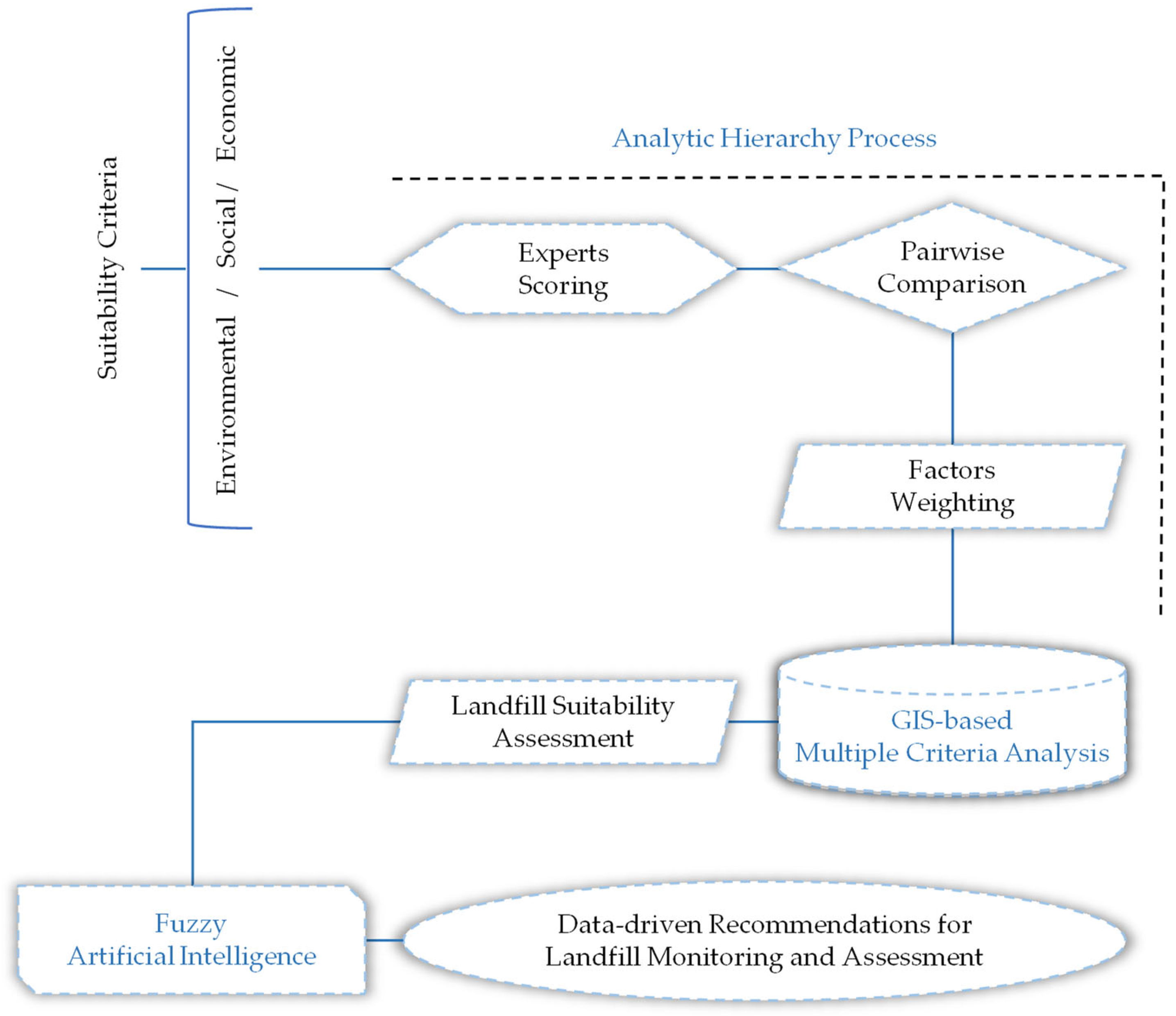
3. Multiple-Criteria Decision Analysis Framework
The identification of optimal MSW disposal sites necessitates a comprehensive assessment of numerous factors [
28]. This study integrates GIS and the AHP, utilizing specific assessment criteria to designate new suitable MSW disposal locations. The development process of the MCDA framework involved the consideration of various criteria, which this study introduces through sequential phases.
The process began with the selection of criteria, which represents an innovative approach due to the utilization of a robust selection of 15 distinct analysis criteria. These criteria were thoughtfully curated following an exhaustive systematic review and meta-analysis of 57 authoritative scholarly articles. This earlier phase of research, introduced by Nascimento et al. [
9], analyzed predominant environmental, economic, and social constraints documented across academic literature spanning from 1996 to 2018.
As a result, our proposed framework strategically incorporates the five most frequently referenced environmental, social, and economic criteria identified through the aforementioned meta-analysis review. These criteria collectively guide the systematic assessment process.
The five pivotal environmental criteria include proximity to surface waters, distance from groundwater sources, distance from protected areas, terrain slope, and distance from fault lines. The quintet of critical social criteria comprises proximity to urban areas, land utilization patterns, distance from cultural, archaeological, and tourist sites, proximity to parks and recreational hubs, and distance from agricultural zones. Lastly, the five essential economic criteria encompass distance from roadways, proximity to airports, distance from power transmission lines, distance from industrial zones, and proximity to gas and oil pipelines. The process of selecting these criteria involved a multidisciplinary approach, incorporating insights from scientific research, compliance with environmental regulations, adherence to urban planning principles, and a focus on safety considerations. These criteria collectively encompass a comprehensive evaluation of the multifaceted factors that must be considered when identifying appropriate landfill sites, all while striving to reduce adverse environmental and social consequences. These criteria can be dynamically adjusted based on specific requirements in real-world applications. The flexibility to modify or expand the criteria allows for customization to suit different geographic locations, environmental conditions, regulatory changes, and evolving research findings. This adaptability ensures that the site selection process remains relevant and responsive to the unique needs and challenges of each landfill project. The flowchart illustrating the proposed framework is shown in
Figure 1.
3.1. Distance from Surface Waters
This criterion is designed to mitigate the potential pollution of surface waters by solid waste. Landfills can generate leachate and gaseous pollutants, posing a significant threat to bodies of water such as lakes, wetlands, ponds, and rivers. The implementation of a buffer zone, maintaining a considerable distance from these water sources, is imperative [
1].
3.2. Groundwater Source Proximity
Within the spectrum of adverse effects stemming from inadequate landfill siting, groundwater pollution is a paramount concern that requires diligent mitigation [
12]. To effectively prevent groundwater contamination, it is crucial to avoid sitting landfills directly on or in close proximity to aquifers [
29].
3.3. Distance from Protected Areas
The objective of this criterion is to establish a significant separation between the landfill site and ecologically sensitive zones. This measure aims to protect threatened or endangered species from potential pollution and the detrimental human activities associated with landfills [
30].
3.4. Land Slope
The inclination of the terrain significantly influences various factors, including drainage patterns, soil moisture content, potential erosion, and the velocity of overland and subsurface flows [
10,
24,
31]. A steep slope can accentuate drainage from the landfill towards downstream areas, increasing the risk of downstream water pollution and necessitating enhanced engineering measures. It also heightens susceptibility to landslides [
24,
32]. Conversely, a level topography can impact runoff drainage dynamics.
3.5. Distance from Fault Lines
The presence of fault lines and fracture zones increases rock permeability, thereby raising the risk of groundwater pollution [
33]. The main objective of this criterion is to prevent potential damage to landfills and the subsequent leakage of pollutants caused by seismic activity and ground displacement. Consequently, avoiding proximity to fault lines is of paramount importance in the strategic selection of landfill sites [
1].
3.6. Distance from Urban Areas
This criterion aims to establish an acceptable range for landfill sitting, taking into careful consideration waste logistics and the well-being of local residents. The chosen site should strike a balance by being adequately close to the urban center to facilitate convenient waste disposal and minimize transportation expenses, while also being sufficiently distant to prevent potential health or environmental repercussions [
23]. The selected location must also consider strategic proximity to waste generation sources since overly lengthy distances can increase transportation costs and response times, which are crucial, especially in the context of disaster recovery [
34]. The presence of a landfill can have pronounced impacts on the nearby populace, including factors such as excessive noise, increased traffic, odorous emissions, litter, and the presence of scavengers.
3.7. Land Use and Land Cover (LULC)
LULC delineates human utilization of the natural environment, including various classes such as agricultural land, forests, and areas influenced by human activities such as settlements, industrial complexes, military installations, and archaeological sites. In the domain of site selection planning, this criterion is of paramount importance due to its inherent connection to understanding both the natural environment and the envisioned LULC patterns [
7,
29].
3.8. Distance from Cultural and Archaeological Areas
To safeguard and conserve the nation’s cultural heritage, which includes a range of paleontological, archaeological, and historical sites, the inclusion of cultural and archaeological areas within or near a landfill site is considered inadequate [
35,
36].
3.9. Distance from Parks and Recreation Areas
This criterion ensures the protection of recreational spaces from potential inconveniences caused by the proximity of a landfill. It is interesting to note that this criterion was addressed in fewer than 6% of all the articles scrutinized by Nascimento et al. [
9]. This relatively low inclusion rate is noteworthy, considering the importance of these areas for fostering social interactions and recreational activities.
3.10. Distance from Agricultural Areas
This criterion aims to protect productive agricultural zones from being used as sites for MSW disposal. Notably, the concept of maintaining a distance from agricultural areas was explored in approximately 16% of the articles evaluated by Nascimento et al. [
9]. The range of values exhibited significant variability, ranging from 50 m, as employed by Charnpratheep et al. [
37] for rice and orchard fields, to 800 m, as stipulated by Motlagh and Sayadi [
38].
3.11. Distance from Roads
The overarching objective of this criterion is to achieve a harmonious balance between logistical requirements and regulatory stipulations governing proximity to transportation infrastructure when designating a landfill site. This involves selecting a location that maintains an appropriate distance from existing roads, a strategic decision aimed at optimizing cost savings related to road construction [
9].
3.12. Distance from Airports
The prudent choice of a landfill site requires a significant separation from airports or airbases, primarily to prevent bird-related hazards during aircraft take-off and landing [
39]. Additionally, the presence of airplane traffic can potentially stir up waste dust [
40]. However, the primary objective of this criterion is to ensure that the landfill maintains a considerable distance to mitigate the risk of aircraft collisions.
3.13. Distance from Powerlines
The fundamental aim of this criterion is to protect the integrity of critical public utilities, specifically power lines. This involves avoiding areas with such infrastructure. However, it is important to note that a landfill’s operational requirements also include the need for electricity. Consequently, ensuring access to a reliable electricity supply is equally significant in the strategic selection of a landfill site [
4].
3.14. Distance from Industries
This criterion is inherently aimed at ensuring the mutual well-being of industries and sanitary landfills. Its main objective is to prevent any adverse effects that could result from proximity—ranging from site assessment and odorous disturbances to noise pollution and potential soil and water contamination. It is worth noting that the consideration of distance from industries was examined in less than 9% of the articles reviewed by Nascimento et al. [
9].
3.15. Distance from Gas and Oil Pipelines
This criterion serves as a safeguard against the potential danger of unintended fires caused by the combustion of solid waste in close proximity to gas pipelines. Its main objective is to prevent any damage to this vital infrastructure [
36].
Table 1 presents the selected location criteria, alongside their corresponding landfill selection values and associated biases categorized into environmental, social, and economic domains.
The subsequent phase of criteria selection involves meticulous preparation of each criterion layer through various spatial analysis processes facilitated by GIS. Initially, the Euclidean Distance tool is employed, and all data layers are uniformly resampled to achieve a 30-m resolution or better. Following this, the Reclassify tool is applied, categorizing the analysis area into five distinct suitability categories for landfill sites: 1—inadequate, 2—low, 3—moderate, 4—high, and 5—very high. The third phase incorporates the AHP to attribute weights to individual criteria and facilitate their comparative assessment. This step culminates in the utilization of the Weighted Overlay tool, which combines the various weighted criteria layers to generate the final suitability map.
In the AHP process, pairwise comparisons among spatial factors are conducted to determine their relative importance. The initial steps involve defining the problem, establishing criteria, and creating a comparison matrix. Eigenvalue techniques are then employed to determine the weights of individual criteria, with the computation of the matrix consistency index. Each factor is systematically compared with other factors, assigning a relative dominance value within the range of 1 to 9. To ensure the consistency of expert judgments, a Consistency Ratio (CR) was calculated. If the calculated CR is equal to or less than 0.10, the paired comparison matrix is considered consistent. In cases where the CR exceeds 0.10, the judgments are reevaluated for consistency.
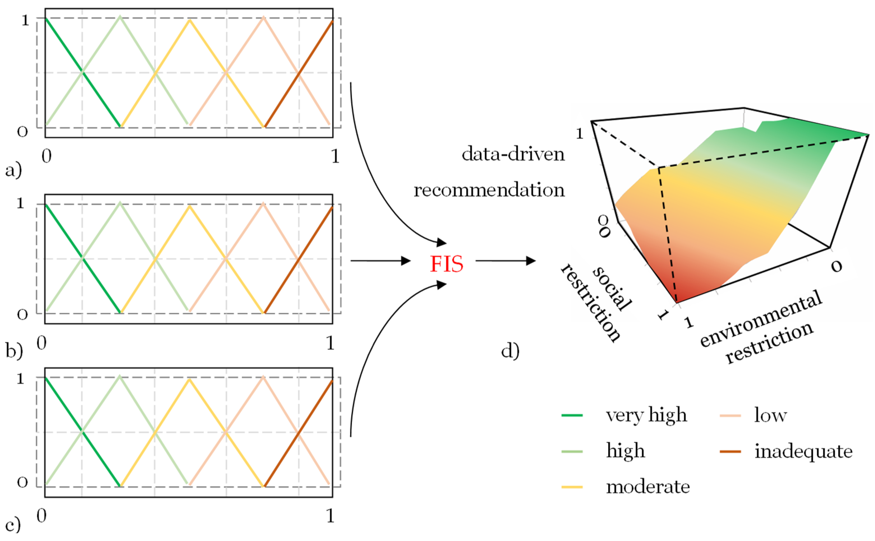
The final integration of criteria within the GIS computational environment for landfill site monitoring and assessment incorporates their weights established by the AHP. As a final step in the proposed framework, the integrated analysis of constraints stemming from environmental, social, and economic criteria is carried out using AI based on a FIS. The choice of fuzzy AI is justified by its capabilities in handling uncertainties [
41,
42,
43]. In the context of landfill site suitability assessment, data may come from diverse sources and possess varying degrees of accuracy and precision. This includes remote sensing data, which often contains inherent uncertainties related to atmospheric conditions, sensor characteristics, and image processing. Fuzzy logic allows for the representation and processing of these uncertainties by employing linguistic variables, membership functions, and fuzzy rules [
44,
45,
46,
47,
48]. It enables a more nuanced approach to decision-making, accommodating imprecise data and providing a degree of flexibility that traditional binary logic may not offer [
49,
50,
51,
52,
53]. This is crucial in situations where the suitability of landfill sites is influenced by complex, interrelated factors, and where precise, deterministic models may fall short in capturing the full spectrum of uncertainty and variability present in the data. The fuzzy inference system in our study was implemented using the Fuzzy Logic Toolbox, available at
https://github.com/PrakritiShetty/GNR633Project_QGISPlugin (accessed on 1 October 2022), integrated into the Quantum GIS geoprocessing software. The FIS encompasses input variables representing environmental, social, and economic suitability, with data-driven recommendations for landfill monitoring and assessment as the output target variable (
Figure 2).
To linguistically model these input variables, a scale consisting of “very high,” “high,” “moderate,” “low,” and “inadequate” levels was applied. In the subsequent model construction phase, the variables underwent fuzzification through the use of triangular membership functions. Following the fuzzification of variables, the rule base was established as shown in
Table 2. Finally,
Table 3 presents the data-driven recommendations proposed by FIS for landfill monitoring and assessment.
4. Application of the GIS-Based MCDA
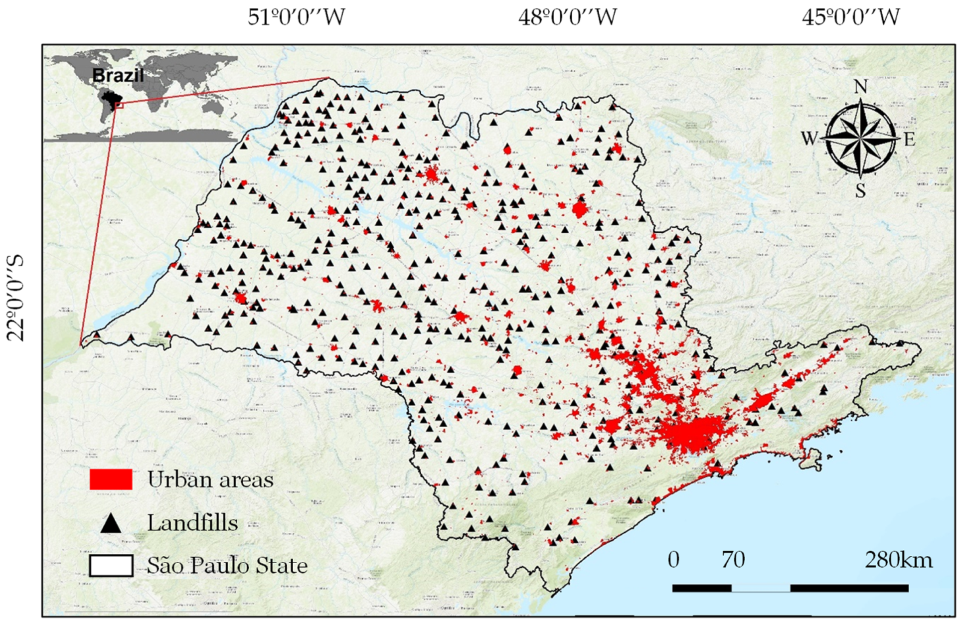
São Paulo, with approximately 46.6 million residents in 2021, is Brazil’s most populous state (
Figure 3). It spans 645 municipalities and covers a total land area of 248,219,481 square kilometers [
54], featuring a diverse topography. Around 85% of its land lies at elevations ranging from 300 to 900 m above sea level, with 8% situated below the 300-m mark, and the remaining 7% rising beyond 900 m. This state also holds the distinction of being Brazil’s primary producer of MSW, generating approximately 40.8 thousand tons per day [
55]. São Paulo state faces stringent regulations regarding landfill sites due to its status as Brazil’s most densely populated region, housing nearly a quarter of the nation’s total population. Additionally, it serves as the epicenter of the country’s most concentrated economic activities [
56], contributing to almost one-third of the national gross domestic product [
57]. The spatial database used in this study was carefully compiled from various data sources, each covering different scales, as outlined in
Table 4.
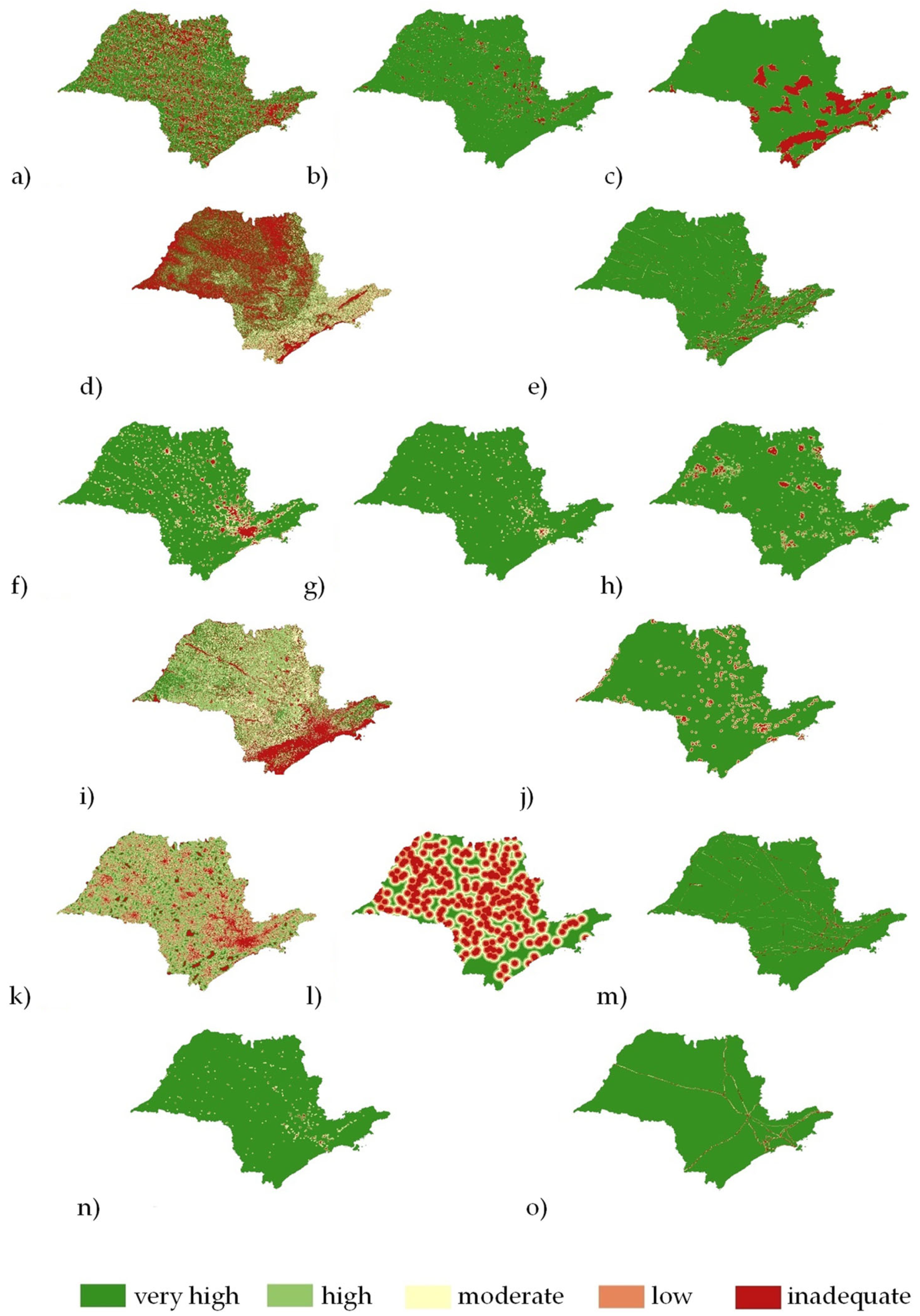
Figure 4 presents a series of maps, each illustrating distinct suitability aspects in environmental, social, and economic scenarios for landfill site selection in the study area. Together, these maps offer valuable visual insights into the spatial implications of each suitability criterion, enhancing our understanding of their combined impact on optimal landfill site selection within the environmental context. In instances where landfills were in close proximity to the border with another state, we took into account the potential implications and concerns associated with the neighboring state’s land. The analysis considered and addressed any relevant restrictions or considerations associated with the strip of land in the neighboring state to ensure a comprehensive and accurate assessment.
Table 5,
Table 6 and
Table 7 present the paired assessment results. Among the environmental criteria, the distance from surface water received the highest weight allocation at 40.82%, followed by groundwater sources at 23.89%. In contrast, the criterion related to fault lines was considered the least critical, with a weight of 6.33%. In the social domain, urban areas were of paramount importance, accounting for 46.87% of the weighting, closely followed by land use at 28.64%. Within the economic domain, the criteria of distance from roads and airports were identified as the most significant, with weightings of 45.84% and 26.46%, respectively.
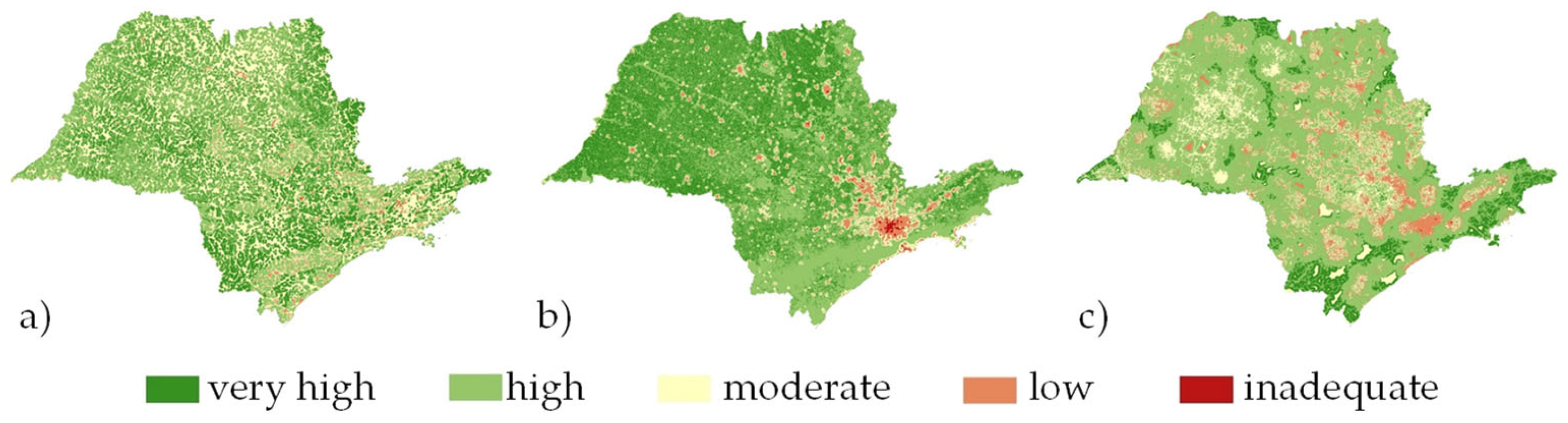
As a result of implementing the proposed framework, utilizing the criteria shown in
Figure 5 as input variables, the GIS-based MCDA led to the reclassification of landfill sites in the study area into five levels of suitability.
In addition to categorizing specific regions into suitability classes for new landfill establishments, the proposed framework can also assess existing landfills. This assessment can guide targeted control measures when necessary. By integrating the analysis of weighted criteria through the AHP methodology,
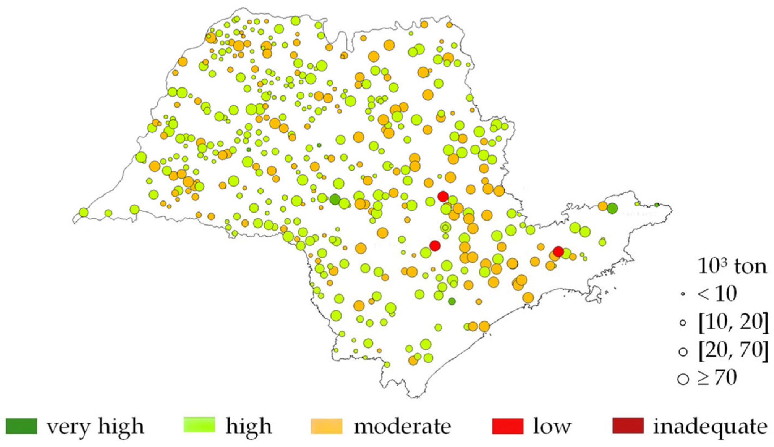
Figure 6 visually depicts the current landfill suitability status within the study area.
In this process, the role of artificial intelligence, particularly fuzzy logic, plays a pivotal role in performing a comprehensive and integrated multicriteria analysis. It recognizes patterns and relationships among various criteria, taking into account their inherent uncertainties and complexities. By doing so, it facilitates data-driven decision-making and generates actionable recommendations for assessment and monitoring. In other words, fuzzy logic helps the framework make sense of the diverse and often imprecise data involved in landfill suitability assessment. It allows for a more nuanced and flexible approach to decision-making, accommodating uncertainties and interrelated factors that traditional binary logic might overlook. The analysis in this study area reveals several strategic recommendations based on current suitability conditions.
A key finding is that a significant majority of existing landfills fall into the categories of ‘High Suitability Areas’ (62.85%) and ‘Moderate Suitability Areas’ (35.24%). These findings highlight the alignment of these landfills with established suitability criteria, indicating their current placement in areas with relatively lower environmental and social risks. Overall, the classification of areas with high suitability is predominantly associated with a greater distance from surface waters, proximity to protected areas, and lower conflict with land use and land cover in the surrounding area. On the other hand, areas with low suitability are characterized by closer proximity to urban areas and a higher terrain slope, which contributes to their lower suitability rating.
For landfills located in ‘High Suitability Areas,’ the FIS recommends maintaining rigorous and regular monitoring protocols. Given the high suitability of these areas, the focus should be on ensuring continued compliance with environmental and social regulations. This includes frequent assessments of water, soil, and air quality. Active engagement with local communities through regular communication and public meetings can help address any concerns. Advanced remote sensing and GIS technologies can be employed for continuous monitoring of the area’s surroundings, providing real-time data for decision-making.
In the case of landfills in ‘Moderate Suitability Areas,’ which represent potential environmental and social challenges, the FIS suggests enhancing monitoring efforts and implementing risk mitigation strategies. Groundwater and surface water quality monitoring should be strengthened due to the potential for contamination. Contingency plans should be developed to address environmental issues promptly. Social concerns can be addressed through community outreach and awareness programs.
A smaller number of landfills fall into the ‘Low Suitability Areas’ (only three landfills). These areas are particularly sensitive and require specialized monitoring and mitigation measures. Stringent odor control measures should be put in place to address social concerns. Long-term monitoring plans are essential to document improvements and track progress towards rehabilitation.
Similarly, for future landfill site selection, the proposed framework can be effectively applied to assess potential areas within the study zone. By applying the environmental, social, and economic criteria and conducting an integrated analysis combining the AHP with FIS in the computational environment of GIS, suitable locations can be identified, ensuring alignment with established suitability criteria.
In summary, the proposed framework offers a comprehensive approach to landfill assessment and monitoring, providing actionable recommendations for both existing and potential landfill sites. By tailoring monitoring strategies to specific suitability categories, responsible landfill management can be achieved while minimizing environmental and social impacts, thereby enhancing the overall sustainability of waste management practices in the study area.
5. Conclusions
In this study, we proposed a comprehensive framework to enhance landfill site monitoring and assessment, addressing the critical need for systematic methods in landfill site selection due to the increasing volumes of MSW worldwide. The framework was developed by integrating GIS-based hierarchical analytical processes with fuzzy AI.
Some key findings and contributions of this study can be highlighted. We developed a rigorous framework that considered 15 distinct criteria across environmental, social, and economic dimensions. The incorporation of FIS allowed us to handle uncertainties inherent in landfill suitability assessment, supporting data-driven decision-making. Moreover, we introduced specific recommendations for each suitability level, guiding targeted control measures, monitoring protocols, and risk mitigation strategies. Our proposed framework not only contributes to the field of landfill site assessment but also offers practical recommendations for sustainable waste management practices. By utilizing our framework and focusing on future research directions, we can enhance landfill site monitoring, reduce environmental and social impacts, and ultimately support more sustainable urban development practices.
A significant benefit of this study is the development of a comprehensive framework for landfill site assessment and management. By considering 15 distinct criteria across environmental, social, and economic dimensions and integrating a fuzzy inference system (FIS) to handle uncertainties, the framework offers a holistic approach to landfill suitability assessment. It provides actionable recommendations for monitoring, control measures, and risk mitigation, which can enhance landfill management practices and contribute to more sustainable waste management. To assess the results recommended by our framework, the active involvement of stakeholders assumes paramount importance, as their contributions hold a central role in the process of validation.
By seeking input and attending to the concerns voiced by pertinent stakeholders, we can ensure that the results faithfully mirror the actual conditions on-site and the unique local circumstances. This collaborative approach enables an assessment of the framework’s results, taking into account the viewpoints of both the technical experts and the community members. However, the framework’s effectiveness depends on data availability and quality, which may vary across different areas. Implementing the proposed framework may also be resource-intensive, potentially posing challenges for regions with limited resources. The study suggests future directions for real-time data integration and the use of advanced technologies, which could further enhance the framework’s utility but are not fully integrated at present.
As future directions, further research should focus on implementing advanced remote sensing technologies and real-time GIS monitoring to continuously assess landfill sites and improve decision-making. Novel research can also emphasize the long-term sustainability of waste management practices, including rehabilitation and improved waste reduction and recycling strategies.
Author Contributions
Conceptualization, A.B. and V.F.N.; data curation, R.G.N.; formal analysis, A.I.S.L. and J.V.O.S.; investigation, A.I.S.L.; methodology, A.B., A.I.S.L. and V.F.N.; software, A.I.S.L., J.V.O.S. and R.G.N.; validation, A.B., V.F.N., J.V.O.S. and R.G.N.; writing—original draft, A.B., A.I.S.L., V.F.N., J.V.O.S. and R.G.N. All authors have read and agreed to the published version of the manuscript.
Funding
This research was funded by Coordination for the Improvement of Higher Education, Ministry of Science, Technology, Innovation and Communications, Brazil.
Institutional Review Board Statement
Not applicable.
Informed Consent Statement
Not applicable.
Data Availability Statement
The data that support the findings of this study are available on request from the corresponding author.
Conflicts of Interest
The authors declare no conflict of interest.
Declaration of Using Generative AI
During the preparation of this work the authors used ChatGPT by OpenAI, in the writing process to improve language and readability. After using this tool/service, the authors reviewed and edited the text as needed and take full responsibility for the content.
References
- Rezaeisabzevar, Y.; Bazargan, A.; Zohourian, B. Landfill site selection using multi criteria decision making: Influential factors for comparing locations. J. Environ. Sci. 2020, 93, 170–184. [Google Scholar] [CrossRef] [PubMed]
- Osra, F.A.; Kajjumba, G.W. Landfill site selection in Makkah using geographic information system and analytical hierarchy process. Waste Manag. Res. 2020, 38, 245–253. [Google Scholar] [CrossRef] [PubMed]
- Associação Brasileira de Empresas de Limpeza Pública e Resíduos Especiais. Panorama dos Resíduos Sólidos no Brasil; Associação Brasileira de Empresas de Limpeza Pública e Resíduos Especiais: São Paulo, Brazil, 2021. [Google Scholar]
- Demesouka, O.E.; Vavatsikos, A.P.; Anagnostopoulos, K.P. GIS-based multicriteria municipal solid waste landfill suitability analysis: A review of the methodologies performed and criteria implemented. Waste Manag. Res. 2014, 32, 270–296. [Google Scholar] [CrossRef] [PubMed]
- Bahrani, S.; Ebadi, T.; Ehsani, H.; Yousefi, H.; Maknoon, R. Modeling landfill site selection by multi-criteria decision making and fuzzy functions in GIS, case study: Shabestar, Iran. Environ. Earth Sci. 2016, 75, 14. [Google Scholar] [CrossRef]
- Yildirim, V. Application of raster-based GIS techniques in the siting of landfills in Trabzon Province, Turkey: A case study. Waste Manag. Res. 2012, 30, 949–960. [Google Scholar] [CrossRef] [PubMed]
- Simsek, C.; Elci, A.; Gunduz, O.; Taskin, N. An improved landfill site screening procedure under NIMBY syndrome constraints. Landsc. Urban Plan. 2014, 132, 1–15. [Google Scholar] [CrossRef]
- Sumathi, V.R.; Natesan, U.; Sarkar, C. GIS-based approach for optimized siting of municipal solid waste landfill. Waste Manag. 2008, 28, 2146–2160. [Google Scholar] [CrossRef]
- Fernandez Nascimento, V.; Loureiro, A.I.S.; Andrade, P.R.; Guasselli, L.A.; Ometto, J.P.B. A worldwide meta-analysis review of restriction criteria for landfill siting using geographic information systems. Waste Manag. Res. 2020, 39, 409–426. [Google Scholar] [CrossRef]
- Gorsevski, P.V.; Donevska, K.R.; Mitrovski, C.D.; Frizado, J.P. Integrating multi-criteria assessment techniques with geographic information systems for landfill site selection: A case study using ordered weighted average. Waste Manag. 2012, 32, 287–296. [Google Scholar] [CrossRef]
- Yazdani, M.; Monavari, S.M.; Omrani, G.A.; Shariat, M.; Hosseini, S.M. A Comparative Assessment of Municipal Solid Waste. Appl. Ecol. Environ. Res. 2017, 15, 91–110. [Google Scholar] [CrossRef]
- Santhosh, L.G.; Sivakumar Babu, G.L. Landfill site selection based on reliability concepts using the DRASTIC method and AHP integrated with GIS—A case study of Bengaluru city, India. Georisk 2018, 12, 1–19. [Google Scholar] [CrossRef]
- Kamdar, I.; Ali, S.; Bennui, A.; Techato, K.; Jutidamrongphan, W. Municipal solid waste landfill siting using an integrated GIS-AHP approach: A case study from Songkhla, Thailand. Resour. Conserv. Recycl. 2019, 149, 220–235. [Google Scholar] [CrossRef]
- Langa, C.; Hara, J.; Wang, J.; Nakamura, K.; Watanabe, N.; Komai, T. Dynamic assessment method for planning sustainable andfills using GIS and multicriteria in areas of urban sprawl with land-use conflicts. PLoS ONE 2021, 16, e0254441. [Google Scholar] [CrossRef]
- Kara, C.; Doratli, N. Application of GIS/AHP in siting sanitary landfill: A case study in Northern Cyprus. Waste Manag. Res. 2012, 30, 966–980. [Google Scholar] [CrossRef] [PubMed]
- Al-Ruzouq, R.; Shanableh, A.; Omar, M.; Al-Khayyat, G. Macro and micro geo-spatial environment consideration for landfill site selection in Sharjah, United Arab Emirates. Environ. Monit. Assess. 2018, 190, 147. [Google Scholar] [CrossRef] [PubMed]
- Khodaparast, M.; Rajabi, A.M.; Edalat, A. Municipal solid waste landfill siting by using GIS and analytical hierarchy process (AHP): A case study in Qom city, Iran. Environ. Earth Sci. 2018, 77, 52. [Google Scholar] [CrossRef]
- Alves, M.C.M.; Lima, B.S.L.P.; Evsukoff, A.G.; Vieira, I.N. Developing a fuzzy decision support system to determine the location of a landfill site. Waste Manag. Res. 2009, 27, 641–651. [Google Scholar] [CrossRef] [PubMed]
- Chang, N.B.; Parvathinathan, G.; Breeden, J.B. Combining GIS with fuzzy multicriteria decision-making for landfill siting in a fast-growing urban region. J. Environ. Manag. 2008, 87, 139–153. [Google Scholar] [CrossRef]
- Zamorano, M.; Molero, E.; Hurtado, A.; Grindlay, A.; Ramos, A. Assessment of a municipal landfill site in Southern Spain with GIS-aided methodology. J. Hazard. Mater. 2008, 160, 473–481. [Google Scholar] [CrossRef]
- Özkan, B.; Sarıçiçek, İ.; Özceylan, E. Assessment of landfill sites using GIS-based MCDA with hesitant fuzzy linguistic term sets. Environ. Sci. Pollut. Res. 2020, 27, 42908–42932. [Google Scholar] [CrossRef]
- Alkaradaghi, K.; Ali, S.S.; Al-Ansari, N.; Laue, J.; Chabuk, A. Landfill site selection using MCDM methods and GIS in the Sulaimaniyah Governorate, Iraq. Sustainability 2019, 11, 4530. [Google Scholar] [CrossRef]
- Aksoy, E.; San, B.T. Geographical information systems (GIS) and Multi-Criteria Decision Analysis (MCDA) integration for sustainable landfill site selection considering dynamic data source. Bull. Eng. Geol. Environ. 2017, 78, 1–13. [Google Scholar] [CrossRef]
- Nascimento, V.F.; Yesiller, N.; Clarke, K.C.; Ometto JP, H.B.; Andrade, P.R.; Sobral, A.C. Modeling the environmental susceptibility of landfill sites in California. GIScience Remote Sens. 2017, 54, 657–677. [Google Scholar] [CrossRef]
- Nascimento, V.F.; da Silva, A.M. Identifying problems for choosing suitable areas for installation of a new landfill through GIS technology: A case study. J. Air Waste Manag. Assoc. 2014, 64, 80–88. [Google Scholar] [CrossRef] [PubMed]
- Senkiio, C.S.; Ramos, A.P.M.; Simões, S.J.C.; Mendes, T.S.G. Multicriteria analysis and logistical grouping method for selecting areas to consortium landfills in Paraiba do Sul river basin, Brazil. Environ. Earth Sci. 2022, 81, 239. [Google Scholar] [CrossRef]
- Morais, L.; Nascimento, V.; Simões, S.; Ometto, J. Regional distance routes estimation for municipal solid waste disposal, case study são paulo state, brazil. Energies 2021, 14, 3964. [Google Scholar] [CrossRef]
- Saketa, Y.; Tamene, N.; Melknew, M. Municipal solid waste disposal site suitability analysis using multi-criteria assessment in Assosa, Ethiopia. Int. J. Environ. Sci. Technol. 2022, 20, 3815–3830. [Google Scholar] [CrossRef]
- Rahmat, Z.G.; Niri, M.V.; Alavi, N.; Goudarzi, G.; Babaei, A.A.; Baboli, Z.; Hosseinzadeh, M. Landfill site selection using GIS and AHP: A case study: Behbahan, Iran. KSCE J. Civ. Eng. 2017, 21, 111–118. [Google Scholar] [CrossRef]
- Mahmood, K.W.; Khzr, B.O.; Othman, R.M.; Rasul, A.; Ali, S.A.; Ibrahim, G.R.F. Optimal site selection for landfill using the boolean-analytical hierarchy process. Environ. Earth Sci. 2021, 80, 173. [Google Scholar] [CrossRef]
- Donevska, K.R.; Gorsevski, P.V.; Jovanovski, M.; Peševski, I. Regional non-hazardous landfill site selection by integrating fuzzy logic, AHP and geographic information systems. Environ. Earth Sci. 2012, 67, 121–131. [Google Scholar] [CrossRef]
- Djokanović, S.; Abolmasov, B.; Jevremović, D. GIS application for landfill site selection: A case study in Pančevo, Serbia. Bull. Eng. Geol. Environ. 2016, 75, 1273–1299. [Google Scholar] [CrossRef]
- Saatsaz, M.; Monsef, I.; Rahmani, M. Site suitability assessment of an old operating landfill using AHP and GIS techniques and integrated hydrogeological and geophysical surveys. Environ. Monit. Assess. 2018, 190, 144. [Google Scholar] [CrossRef] [PubMed]
- Cheng, C.; Thompson, R.G. Application of boolean logic and GIS for determining suitable locations for Temporary Disaster Waste Management Sites. Int. J. Disaster Risk Reduct. 2016, 20, 78–92. [Google Scholar] [CrossRef]
- Kontos, T.D.; Komilis, D.P.; Halvadakis, C.P. Siting MSW landfills on Lesvos island with a GIS-based methodology. Waste Manag. Res. 2003, 21, 262–277. [Google Scholar] [CrossRef]
- Chabuk, A.; Al-Ansari, N.; Hussain, H.M.; Knutsson, S.; Pusch, R. Landfill site selection using geographic information system and analytical hierarchy process: A case study Al-Hillah Qadhaa, Babylon, Iraq. Waste Manag. Res. 2016, 34, 427–437. [Google Scholar] [CrossRef] [PubMed]
- Charnpratheep, K.; Zhou, Q.; Garner, B. Preliminary landfill site screening using fuzzy geographical information systems. Waste Manag. Res. 1997, 15, 197–215. [Google Scholar] [CrossRef]
- Motlagh, Z.K.; Sayadi, M.H. Siting MSW landfills using MCE methodology in GIS environment (Case study: Birjand plain, Iran). Waste Manag. 2015, 46, 322–337. [Google Scholar] [CrossRef] [PubMed]
- Mallick, J. Municipal solid waste landfill site selection based on fuzzy-ahp and geoinformation techniques in ASIR region Saudi Arabia. Sustainability 2021, 13, 1538. [Google Scholar] [CrossRef]
- Ahmad, S.Z.; Ahamad, M.S.S.; Yusoff, M.S. Spatial effect of new municipal solid waste landfill siting using different guidelines. Waste Manag. Res. 2013, 32, 24–33. [Google Scholar] [CrossRef]
- Bressane, A.; Biagolini, C.H.; Mochizuki, P.S.; Roveda, J.A.F.; Lourenço, R.W. Fuzzy-based methodological proposal for participatory diagnosis in the linear parks management. Ecol. Indic. 2017, 80, 153–162. [Google Scholar] [CrossRef]
- Sahu, K.; Srivastava, R.K. Soft computing approach for prediction of software reliability. Neural Netw. 2018, 17, 19. [Google Scholar]
- Sahu, K.; Srivastava, R.K.; Kumar, S.; Saxena, M.; Gupta, B.K.; Verma, R.P. Integrated hesitant fuzzy-based decision-making framework for evaluating sustainable and renewable energy. Int. J. Data Sci. Anal. 2023, 16, 371–390. [Google Scholar] [CrossRef]
- Spandagos, C.; Ng, T.L. Fuzzy model of residential energy decision-making considering behavioral economic concepts. Appl. Energy 2018, 213, 611–625. [Google Scholar] [CrossRef]
- Sahu, K.; Srivastava, R.K. Predicting software bugs of newly and large datasets through a unified neuro-fuzzy approach: Reliability perspective. Adv. Math. Sci. J. 2021, 10, 543–555. [Google Scholar] [CrossRef]
- Bressane, A.; da Silva, P.M.; Fiore, F.A.; Carra, T.A.; Ewbank, H.; De-Carli, B.P.; da Mota, M.T. Fuzzy-based computational intelligence to support screening decision in environmental impact assessment: A complementary tool for a case-by-case project appraisal. Environ. Impact Assess. Rev. 2020, 85, 106446. [Google Scholar] [CrossRef]
- Bressane, A.; Spalding, M.; Zwirn, D.; Loureiro, A.I.S.; Bankole, A.O.; Negri, R.G.; de Brito Junior, I.; Formiga, J.K.S.; Medeiros, L.C.d.C.; Pampuch Bortolozo, L.A.; et al. Fuzzy artificial intelligence—Based model proposal to forecast student performance and retention risk in engineering education: An alternative for handling with small data. Sustainability 2022, 14, e14071. [Google Scholar] [CrossRef]
- Deliktaş, D.; Şahinöz, Ö. A novel fuzzy group decision-making approach based on CCSD method for thermal insulation board selection problem: A case study. Eng. Appl. Artif. Intell. 2023, 121, 105986. [Google Scholar] [CrossRef]
- Mota, M.T.D.; Bressane, A.; Roveda, J.A.F.; Roveda, S.R.M.M. Classification of successional stages in atlantic forests: A methodological approach based on a fuzzy expert system. Ciência Florest. 2019, 29, 519–530. [Google Scholar] [CrossRef]
- Bressane, A.; Goulart, A.P.G.; Melo, C.P.; Gomes, I.G.; Loureiro, A.I.S.; Negri, R.G.; Moruzzi, R.; Reis, A.G.d.; Formiga, J.K.S.; da Silva, G.H.R.; et al. A Non-Hybrid Data-Driven Fuzzy Inference System for Coagulant Dosage in Drinking Water Treatment Plant: Machine-Learning for Accurate Real-Time Prediction. Water 2023, 15, 1126. [Google Scholar] [CrossRef]
- Bressane, A.; Gomes, I.G.; da Rosa, G.C.S.; Brandelik, C.C.M.; Silva, M.B.; Siminski, A.; Negri, R.G. Computer-aided classification of successional stage in subtropical Atlantic Forest: A proposal based on fuzzy artificial intelligence. Environ. Monit. Assess. 2023, 195, 184. [Google Scholar] [CrossRef]
- Bressane, A.; Fengler, F.H.; Roveda, S.R.M.M.; Roveda, J.A.F.; Martins, A.C.G. Arboreal identification supported by fuzzy modeling for trunk texture recognition. Trends Comput. Appl. Math. 2018, 19, 111–125. [Google Scholar] [CrossRef]
- Bressane, A.; Mochizuki, P.S.; Caram, R.M.; Roveda, J.A.F. A system for evaluating the impact of noise pollution on the population's health. Rep. Public Health 2016, 32, e00021215. [Google Scholar]
- Instituto Brasileiro de Geografia e Estatística (IBGE). Estimativas da População Residente no Brasil e Unidades da Federação com Data de Referência em 1o de Julho de 2021; Inst Bras Geogr e Estatística: Rio de Janeiro, Brazil, 2021; pp. 1–119. [Google Scholar]
- Companhia Ambiental do Estado de São Paulo. Inventário Estadual de Resíduos Sólidos Urbanos; Companhia Ambiental do Estado de São Paulo: São Paulo, Brazil, 2020. [Google Scholar]
- Dalmo, F.C.; Simão, N.M.; de Lima, H.Q.; Jimenez, A.C.M.; Nebra, S.; Martins, G.; Palacios-Bereche, R.; de Mello Sant’Ana, P.H. Energy recovery overview of municipal solid waste in São Paulo State, Brazil. J. Clean. Prod. 2019, 212, 461–474. [Google Scholar] [CrossRef]
- Instituto Brasileiro de Geografia e Estatística. Dados de Drenagem de Municípios Brasileiros; Instituto Brasileiro de Geografia e Estatística: São Paulo, Brazil, 2017. [Google Scholar]
- Companhia de Pesquisa de Recursos. Sistema de Informações de Águas Subterrâneas; Companhia de Pesquisa de Recursos: Brasília, Brazil, 2016. [Google Scholar]
- Ministério do Meio Ambiente. Dados Unidade de Conservação. 2016. Available online: https://antigo.mma.gov.br/areas-protegidas/cadastro-nacional-de-ucs/dados-georreferenciados.html (accessed on 1 October 2022).
- Companhia de Pesquisa de Recursos. Mapa de Declividade em Percentual do Relevo Brasileiro- Dados Declividade. 2010. Available online: http://www.cprm.gov.br/publique/Gestao-Territorial/Gestao-Territorial/Mapa-de-Declividade-em-Percentual-do-Relevo-Brasileiro-3497.html dados declividade (accessed on 1 October 2022).
- Companhia de Pesquisa de Recursos. Falhas Geológicas. 2006. Available online: https://geosgb.cprm.gov.br/geosgb/downloads.html (accessed on 1 October 2022).
- Empresa Brasileira de Pesquisa Agropecuária. Dados da Area Urbana de Muncípios Brasileiros; Empresa Brasileira de Pesquisa Agropecuária: Teresina, Brazil, 2015. [Google Scholar]
- MAPBIOMAS. 2021. Available online: https://mapbiomas.org/colecoes-mapbiomas-1?cama_set_language=pt-BR (accessed on 1 October 2022).
- Open Streetmap. 2021. Open Streetmap. Available online: https://www.openstreetmap.org/#map=4/-15.13/-53.19 (accessed on 1 October 2022).
Figure 1.
GIS-based MCDA framework.
Figure 1.
GIS-based MCDA framework.
Figure 2.
FIS: (a) environmental, (b) social, and (c) economic suitability; (d) decision surface of data-driven recommendations.
Figure 2.
FIS: (a) environmental, (b) social, and (c) economic suitability; (d) decision surface of data-driven recommendations.
Figure 3.
Geographic distribution of landfills within the state of São Paulo, Brazil.
Figure 3.
Geographic distribution of landfills within the state of São Paulo, Brazil.
Figure 4.
Suitability considering the distance from analysis criteria: (a) surface water, (b) groundwater fount, (c) protected areas, (d) slope, (e) fault lines, (f) urban areas, (g) LULC, (h) cultural and archaeological areas, (i) park and recreation areas, (j) agricultural areas, (k) roads, (l) airports, (m) power lines, (n) industries, and (o) gas and oil pipelines.
Figure 5.
Landfill site suitability assessment based on: (a) environmental, (b) social, and (c) economic criteria.
Figure 5.
Landfill site suitability assessment based on: (a) environmental, (b) social, and (c) economic criteria.
Figure 6.
Landfill site suitability assessment within the study area, and respective data-drive recommendations by FIS.
Figure 6.
Landfill site suitability assessment within the study area, and respective data-drive recommendations by FIS.
Table 1.
Criteria proposed for landfill monitoring and assessment.
Table 1.
Criteria proposed for landfill monitoring and assessment.
| Environmental | Value * | Bias | Social | Value * | Bias | Economical | Value * | Bias |
|---|
| surface waters | <200 | 1 | urban/residential areas (m) | <500 | 1 | airports ** | <10 | 1 |
| 200–300 | 2 | 500–1000 | 2 | 10–15 | 2 |
| 300–500 | 3 | 1000–2000 | 3 | 15–20 | 3 |
| 500–800 | 4 | 2000–3000 | 4 | 20–25 | 4 |
| >800 | 5 | >3000 | 5 | >25 | 5 |
| groundwater fount | <100 | 1 | cultural /archeologic/tourism areas | <2000 | 1 | power lines | <30 | 1 |
| 100–200 | 2 | 2000–3000 | 2 | 30–130 | 2 |
| 200–400 | 3 | 3000–4000 | 3 | 130–200 | 3 |
| 400–500 | 4 | 4000–5000 | 4 | 200–250 | 4 |
| >500 | 5 | >5000 | 5 | >250 | 5 |
| slope *** | <2 | 1 | parks/recreation areas | <500 | 1 | roads | <100 | 1 |
| 2–5 | 5 | 500–1000 | 2 | 100–300 | 2 |
| 5–10 | 4 | 1000–2000 | 3 | 300–500 | 3 |
| 10–20 | 3 | 2000–3000 | 4 | 500–3000 | 4 |
| 20–30 | 2 | >3000 | 5 | 3000–5000 | 5 |
| >30 | 1 | | | | >5000 | 1 |
| protected areas | <250 | 1 | agricultural areas | <400 | 1 | gas and oil pipelines | <250 | 1 |
| 250–500 | 2 | 400–800 | 2 | 250–500 | 2 |
| 500–750 | 3 | 800–1000 | 3 | 500–750 | 3 |
| 750–1000 | 4 | 1000–3000 | 4 | 750–1000 | 4 |
| >1000 | 5 | >3000 | 5 | >1000 | 5 |
| fault lines | <100 | 1 | land use | A | 1 | industries | <750 | 1 |
| 100–300 | 2 | B | 2 | 750–1000 | 2 |
| 300–500 | 3 | C | 3 | 1000–2000 | 3 |
| 500–1000 | 4 | D | 4 | 2000–3000 | 4 |
| >1000 | 5 | E | 5 | >3000 | 5 |
Table 2.
Suitability based on FIS.
Table 2.
Suitability based on FIS.
| | Environmental |
|---|
| Economic | Social | Very High | High | Moderate | Low | Inadequate |
|---|
| very high | very high | 1 | 1 | 2 | 2 | 5 |
| High | 1 | 1 | 2 | 3 | 5 |
| moderate | 1 | 2 | 3 | 4 | 5 |
| Low | 2 | 3 | 4 | 4 | 5 |
| inadequate | 5 | 5 | 5 | 5 | 5 |
| high | very high | 1 | 1 | 2 | 3 | 5 |
| High | 1 | 2 | 3 | 3 | 5 |
| moderate | 2 | 2 | 3 | 4 | 5 |
| Low | 3 | 3 | 3 | 4 | 5 |
| inadequate | 5 | 5 | 5 | 5 | 5 |
| moderate | very high | 2 | 2 | 3 | 3 | 5 |
| High | 2 | 2 | 3 | 3 | 5 |
| moderate | 3 | 3 | 3 | 2 | 5 |
| Low | 3 | 3 | 3 | 4 | 5 |
| inadequate | 5 | 5 | 5 | 5 | 5 |
| low | very high | 2 | 2 | 3 | 4 | 5 |
| High | 3 | 2 | 3 | 4 | 5 |
| moderate | 3 | 3 | 3 | 4 | 5 |
| Low | 4 | 3 | 4 | 4 | 5 |
| inadequate | 5 | 5 | 5 | 5 | 5 |
| inadequate | very high | 5 | 5 | 5 | 5 | 5 |
| High | 5 | 5 | 5 | 5 | 5 |
| moderate | 5 | 5 | 5 | 5 | 5 |
| Low | 5 | 5 | 5 | 5 | 5 |
| inadequate | 5 | 5 | 5 | 5 | 5 |
Table 3.
Landfill monitoring and assessment recommended by FIS.
Table 3.
Landfill monitoring and assessment recommended by FIS.
| Suitability Group | Fuzzy AI—Based Recommendations |
|---|
| 1 | very high | A long-term monitoring strategy should include: (i) implementing a continuous monitoring program to maintain highly suitable areas; (ii) conducting regular inspections to detect signs of environmental impacts or operational issues at the landfills; and (iii) using remote sensing and image analysis to assess changes in the surrounding area over time. |
| 2 | high | A regular monitoring strategy should include: (i) setting a schedule for compliance assessment with environmental and social regulations; (ii) conducting water, soil, and air sampling at specific intervals to verify environmental quality; and (iii) monitoring the impact on neighboring communities through surveys and stakeholder engagement. |
| 3 | moderate | Intensive monitoring strategy, including: (i) implement a more intensive monitoring system due to the potential for environmental and social challenges; (ii) conduct detailed groundwater and surface water quality analyses, focusing on possible contaminations; and (iii) continuously assess landfill operational performance to ensure timely issue mitigation. |
| 4 | low | Specialized monitoring strategy, including: (i) due to the lower suitability level, focus on mitigation and remediation strategies; (ii) implement advanced effluent treatment systems and stringent odor control measures; and (iii) maintain a long-term monitoring program to document area evolution and improvements. |
| 5 | inadequate | Closure and rehabilitation strategy, including: (i) close the landfill and initiate the area rehabilitation process; (ii) execute a decommissioning plan, including proper waste removal and land restoration; (iii) continuously monitor the area post-closure to ensure successful restoration and minimize residual impacts. |
Table 4.
Spatial data used to study cases.
Table 4.
Spatial data used to study cases.
| Parameter | Source | Scale |
|---|
| Distance from surface waters | [57] | 1:250,000 |
| Distance from groundwater fount | [58] | - |
| Distance from protected areas | [59] | 1:25,000 |
| Slope | [60] | 1:50,000 |
| Distance from fault lines | [61] | 1:1,000,000 |
| Distance from urban areas | [62] | 1:250,000 |
| Land use | [63] | 1:250,000 |
| Distance from cultural and archaeological areas | [57] | 1:250,000 |
| Distance from parks and recreation areas | [64] | - |
| Distance from agricultural areas | [63] | 1:250,000 |
| Distance from roads | [64] | - |
| Distance from airports | [64] | - |
| Distance from powerlines | [63] | 1:250,000 |
| Distance from industries | [64] | - |
| Distance from gas and oil pipelines | [63] | 1:250,000 |
Table 5.
Pairwise assessment of environmental suitability (CR = 0.017).
Table 5.
Pairwise assessment of environmental suitability (CR = 0.017).
| | Slope | Surface Waters | Protected Areas | Groundwater Fount | Faultlines | Weight |
|---|
| slope | 1 | 1/3 | 1 | 1/2 | 3 | 14.48% |
| surface waters | 3 | 1 | 3 | 2 | 5 | 40.82% |
| protected areas | 1 | 1/3 | 1 | 1/2 | 3 | 14.48% |
| groundwater | 2 | 1/2 | 2 | 1 | 3 | 23.89% |
| faultlines | 1/3 | 1/5 | 1/3 | 1/3 | 1 | 6.33% |
Table 6.
Pairwise assessment of social suitability (CR = 0.035).
Table 6.
Pairwise assessment of social suitability (CR = 0.035).
| | LULC | Urban Areas | Cultural/Archaeological | Agricultural Areas | Recreation Areas | Weight |
|---|
| LULC | 1 | 1/3 | 4 | 5 | 4 | 28.64% |
| urban areas | 3 | 1 | 4 | 6 | 4 | 46.87% |
| cultural/arch, | ¼ | 1/4 | 1 | 2 | 1 | 9.48% |
| agricultural areas | 1/5 | 1/6 | 1/2 | 1 | 1/2 | 5.53% |
| recreation areas | ¼ | 1/4 | 1 | 2 | 1 | 9.48% |
Table 7.
Pairwise assessment of economical suitability (CR = 0.047).
Table 7.
Pairwise assessment of economical suitability (CR = 0.047).
| | Roads | Powerlines | Industries | Airport | Gas/Oil and Pipelines | Weight |
|---|
| Roads | 1 | 3 | 5 | 3 | 5 | 45.84% |
| Powerlines | 1/3 | 1 | 1 | 1/3 | 3 | 12.44% |
| Industries | 1/5 | 1 | 1 | 1/3 | 1 | 8.77% |
| Airport | 1/3 | 3 | 3 | 1 | 5 | 26.46% |
| gas/oil and pipelines | 1/5 | 1/3 | 1 | 1/5 | 1 | 6.50% |
| Disclaimer/Publisher’s Note: The statements, opinions and data contained in all publications are solely those of the individual author(s) and contributor(s) and not of MDPI and/or the editor(s). MDPI and/or the editor(s) disclaim responsibility for any injury to people or property resulting from any ideas, methods, instructions or products referred to in the content. |
© 2023 by the authors. Licensee MDPI, Basel, Switzerland. This article is an open access article distributed under the terms and conditions of the Creative Commons Attribution (CC BY) license (https://creativecommons.org/licenses/by/4.0/).

 ,
, 


