
Considering Imperial Complexity in Prehistory: A Polyethnic Wari Enclave in Moquegua, Peru

Department of Anthropology, University of North Carolina Greensboro, 439 Graham Building, Greensboro, NC 27402-6170, USA
Humans 2022, 2(3), 104-137; https://doi.org/10.3390/humans2030008
Submission received: 23 May 2022
/
Revised: 4 August 2022
/
Accepted: 22 August 2022
/
Published: 31 August 2022
Abstract
:Wari is thought by many to be the first Andean Empire (ca. 600–1000 AD); however, the means of expansion, the areas controlled, the strength of the polity, and the nature of Wari institutions remain largely contested. In general, models describing the Wari polity are simplistic and do not exploit sophisticated approaches developed by historical archaeologists. Wari expansion into the Moquegua Valley, Peru, was originally interpreted as an intrusive colony or distant outpost, perhaps to engage its southern neighbor, Tiwanaku. It was presumed that migrants from the polity’s core established settlements and imperial infrastructure in an unoccupied ecozone. Recent research of households in the colony reveals diverse domestic material culture, diets, and use of living space. Those who lived in Wari-affiliated settlements were probably drawn from other imperial provinces and communities from other areas of the drainage. Forced relocations are common among historically documented empires, but willing pioneers may have selected for this tenuous frontier. Regional-scale data show that Wari had the strength to change the local economy and control this distant frontier province; household-scale data reveal the polyethnic nature of the colonial enclave and provide clues to understand early imperial institutions.
Keywords:
states; empire; household archaeology; migration; colonization; political economy; Wari; Inka; Moquegua1. Introduction
First-generation states, such as early dynastic Egypt, its contemporary Uruk, and South America’s Wari polity command theoretical interest because their institutional configurations differed from their successors [1]. Rather than being small versions of later polities, archaic states can be viewed as experimental regimes with unique institutions; the study of the polities can reveal developmental trajectories that can only be understood through archaeological investigation [2] (p. 113). This does not mean that advances made by historical archaeologists should be ignored, especially when modeling change in polyethnic settings [3]. Since most empires have written records that indicate the extent of their domain and the general character of their subjects, the models used by prehistorians to understand political expansion are underdeveloped. Many early states, like later empires, expanded beyond their geographic core and incorporated foreign groups. Those that were sufficiently successful to leave traces in the archaeological record probably made strategic decisions about their own administrative capabilities and limitations [4] (pp. 8–10), especially if economic extraction or long-term colonization were the goal. Observing the features of these initial expansions, and the material manifestations of these decisions, can shed light on the development of statecraft and imperial institutions. In this paper, I consider the Wari Empire, a prehistoric Andean Polity that expanded in the second half of the first millennium, and the practical realities of this enterprise along their southern frontier in Moquegua, Peru. I review archaeological models of state organization and imperial institutions in practice at the time of European contact. These provide useful guidance to understand the early Wari Empire but fall short of capturing the complexities of prehistoric Andean imperialism revealed through household archaeology.
1.1. Identifying Early Empires
In a synthetic article, Algaze [5] presents a cross-cultural examination of cost-efficient modes of distant resource procurement typical of archaic states and a feature of imperial polities. He found that the degree of political centralization in the periphery influenced how early states obtained or extracted goods. When strong polities lie in the hinterland, an expanding state might place an enclave within an existing center of exchange. Alternatively, to interact with distant peer polities, states could create “gateway communities” at important, but unsettled, trade junctures. Outposts could also be created for direct extraction of desirable resources in regions lacking strong political organization [5] (pp. 321–322). In Algaze’s cases, delegates from the political core are sent to peripheries to implement state interests; however, expansive states have also extracted resources by working through foreign clients [6] (p. 19) [7] (pp. 37–38) [8] (p. 100) [9] (p. 5). The relationship between a core and province may change over time e.g., [10]. As empires mature provincials can become agents of political expansion.
Many archaic states had the means to establish distant outposts or trade enclaves but varied in their ability to integrate remote holdings. According to Stein [11] (p. 11–12), differences fall along a continuum of segmentary to unitary state organization. Segmentary states have a power gradient with the core exercising the greatest administrative control that decreases with outgoing distance. Representing limited power over segment managers of outlying areas, local economies were infrequently restructured to benefit core interests. In contrast, unitary states have strong webs of interrelated administrative levels differentiated by ranked access to privileges. These polities have the capacity to alter local economies and extract more resources. States can have outposts or colonies in distant territories without imposing dramatic changes on locals, at least for the first generation or two. Relations between cores and colonies can differ; the strength of integration indicates the relative growth of a state’s administrative prowess and its stability [11]. A state’s organization may be determined by assessing to what degree peripheral areas were integrated into the state’s economy through notable changes to local economies. An archaeologist could tentatively label something an empire if control is strong, and expansive state if political power was weak. Stein’s association of unitary states with stability and segmentary polities as unstable is somewhat contradicted by recent models of collapse and resilience, which predict that polities as systems are susceptible to collapse as they become increasingly interconnected and interdependent, see [12,13]. These contrasting propositions require further testing and refinement with case studies that describe the relations between cores and colonies in terms of changing economies, integration, and interdependence. I offer the Wari Empire’s frontier province in Moquegua, Peru, as one such case study and also suggest some ways researchers can approach longitudinal change to attain more nuanced models; more household archaeology is needed to understand political expansion.
1.2. The Wari Empire of Peru
Researchers working in several regions of Peru assert that there was a Wari Empire in the latter half of the first millennium with a large urban capital at Huari (ca. 15 km squared), which is located in the department of Ayacucho [14,15,16,17,18,19,20]. In the highlands, several monumental complexes exhibit Wari architectural canons and resemble buildings in the polity’s core. These sites are spread over an expanse of 1300 km from north to south (Figure 1). Sites located below 2500 masl in the western watershed of the Andes are somewhat different (e.g., Huaca Santa Rosa de Pucalá, [21]; Huaca del Loro, [22]; Pataraya [23]). Similar to imperial architecture of the later Inka era (ca. 1400–1532 CE), coastal complexes are more difficult to identify, imperial features are more subtle, and may be executed in different building materials such as adobe. Many more coastal sites are affiliated with Wari through material culture (e.g., Castillo de Huarmey [16]; Huaca Pucllana, [24]; Pachacamac, [25]; Cerro del Oro, [26]), which can be interpreted as a trade relationship rather than evidence of conquest or colonization. Even when such goods are locally produced, some researchers prefer narratives involving influence and imitations rather than political affinity.
Schreiber [27] who advocated for an imperial polity, described provinces with monumental Wari centers as areas under direct control, and those lacking Wari style architecture, but with numerous Wari style prestige goods as provinces under some form of indirect control. Through her work in the Sondondo Valley, she documented the type of regional restructuring that Stein would associate with a unitary state. Wari incursion saw populations move from the tuber-puna ecotone to the lower grain-tuber ecotone, and the valley was terraced for the first time to intensify agricultural production. A Wari style administrative center, Jincamocco, and three smaller subsidiary centers were built along a road system of Wari construction. The relocation of settlement and changes in the agricultural economy would have transformed the region forever and indicates imperial action. Despite this example, its proximity (approximately 150 km as the crow flies) to the Wari capital left room for doubt as to whether this expansion should be considered imperial. The investments in infrastructure and changes in settlement that took place in Moquegua, more than 500 km to the south of the capital, are another matter.
In Moquegua, evidence of Wari intrusion is unquestionable. There is no indication of a substantial, organized polity in the valley capable of establishing the regional infrastructure or that could have been indirectly controlled for resource extraction by the Wari Polity ca. AD 600. Wari agents had to engage with local groups and bring in outsiders to establish a colony in Moquegua. These interactions took place for several centuries (ca. 650–1100 AD, see Table 1). Results of household excavations, which I detail below, indicate that Wari-affiliated settlements were poly-ethnic, composed of people from other provinces and locals, and occupied by permanent rather than transient populations. This scenario is a bit more complicated than Algaze and Stein propose but aligns with historical examples e.g., [28,29]. Ethnohistoric accounts of the Inka Empire describe institutions of demographic management. I review these imperial practices to contextualize the earlier Wari case study and outline material correlates.
This study raises an important issue relevant to Wari imperialism and forms of political expansion in general. It is often assumed that state officials dictated population movements and demographic reorganization; however, we must also consider that some transformations of this kind resulted from compromises between local and intrusive groups (e.g., the negotiation of tax obligations [31]. It is possible, at least in the case of Moquegua, that Wari colonization and the construction of infrastructure may have benefitted subject populations to some degree. At the same time, I will not overly emphasize resistance or resilience as it can whitewash the often-harsh realities of imperial projects. No doubt both were at play on a daily basis and stimulated some changes, but they did not overcome state-affiliated actors. The existence of Cerro Mejía the site I describe is the outcome of an imperial agenda. My goal is to gain a practical, ‘balanced’ perspective and examine top-down strategies as well as bottom-up concerns to understand the dynamics of empire [32] (p. 224) [33] (pp. 75–76).
In the arid Torata tributary of the upper Moquegua Valley (2000–3200 masl), the Wari Empire established its farthest southern outpost (Figure 1 and Figure 2). Downstream, the middle Moquegua Valley had long been settled by local Huaracane people [34] (p. 209) [35] (pp. 343–344) and later by two waves of Tiwanaku immigrants from the Lake Titicaca region [36] (pp. 311–315). Yet the rugged terrain of the Torata sierra around Cerro Baúl and Cerro Mejía appears to have been relatively vacant until Wari expansion [37] (p. 175), likely because of the technical difficulty of navigating canals around the broken terrain. Wari opened the area to colonization by construction of a canal system more than 20 km long, which reclaimed at least 700 ha of land [38] (pp. 320–321), a major feat of engineering. At least part of this system was in use by AD 650 (Table 1). The prominent mesa summit of Cerro Baúl was occupied by Wari-affiliated immigrants who lived in monumental architecture, made and used prestige goods, and performed ritual practices in ways that demonstrate extensive communication and interaction with the Wari capital and other provinces [19,39,40,41,42,43]. Larger, lower, but less densely settled, Cerro Mejía was occupied by people whose architecture, artifacts, and ritual depositions were more diverse [44,45]. Both monumental sites were settled before AD 700; neither has evidence of Formative Era (pre-600AD) activity. The site of Cerro Petroglifo was never occupied. A recent date from a construction offering indicates settlement expansion was underway after AD 1050, but this project was never completed (Table 1).
2. Materials and Methods
Archaeological approaches to examine the impact of inter-cultural encounters must rely on several scales of evidence e.g., [46] (p. 477) [31] (p. 448). Settlement patterns alone can indicate significant changes in the local economy. In the first millennium such shifts in the Andean western watershed may be attributed to environmental factors, such as the three droughts that occurred between 500 and 650 AD [47] or the El Niño flood event ca. 700 AD [48], rather than raiding or conquest. In this case, Stein’s model is instructive, providing a means to evaluate the nature, if any, of hinterland integration using multiple lines of evidence. Research programs must examine local economies to determine how expansive states implemented institutions and impacted local communities by assessing what resources were in use, what was produced, what was consumed, and what domestic or prestige goods moved between households and communities e.g., [20]. Identifying colonists requires an emphasis on quotidian features; an overemphasis on prestige goods can be misleading.
Often, the difference between Wari “influence” and “control” has been judged based on the number of state branded ceramics or prestige goods of other sorts, as well as how closely the style of locally produced prestige goods adheres to artistic canons of the polity’s core, even though their variation is not well understood. Both methodologies are problematic because they fail to recognize that elite strategies may differ between regions or that stylistic variations may represent factions, lineages, or other competitive interest groups [39]. In some areas, the imperial elite may have restricted the circulation of certain goods or prohibited the emulation of particular icons, such as the sumptuary laws implemented by the Inka [49] (p. 105).
The distribution of Inka wares provides a good example. Inka pottery is rare in most regions. It is often confined, for the most part, to elite or ceremonial contexts. Additionally, Inka pottery was produced in many provinces by local potters resulting in vessels that could be described as hybrids or as low-quality local imitations e.g., [50] (pp. 338, 347) [51] (pp. 341–342). Such vessels would likely be interpreted as representing “influence” if it were not for historical records to the contrary. Some provincial workshops also produced high quality examples that resemble those from the heartland [52]. Relying on the quantity or presence and style of prestige goods alone cannot effectively distinguish between patron-client relations of indirect imperial control versus the agency of local elites employing prestige goods obtained through an elite interaction sphere to build local power [36].
Geochemical analyses have shown that fine Wari vessels considered as possible imports were actually produced locally with the same ingredients as more modest vessels e.g., [53,54]. The wealth finance model originated in the Andes [54] and has been proposed to apply to Wari [55] but the sourcing of raw materials and studies focused on ceramic production indicate that neither Wari or Inka pottery are distributed in a manner that would correspond with wealth finance models e.g., [56] (p. 71) [40], although that is not to say that other goods were not distributed as such.
Study of the Wari province in Moquegua and the relationship between support personnel and elite administrators has examined multiple lines of evidence, including the production and circulation of locally produced prestige goods, the distribution of imported commodities, and differential access to other resources [20,40,57,58,59,60,61]. It is also important to look for change among all the groups engaged in interaction. Foreign Wari officials were just as likely to modify some practices or institutions as subordinate populations were to change aspects of their cultural traditions. It is also possible that some policies derived from shared regional goals rather than uniformly originating from the imperial core. Such compromises may not have been crucial to initial expansion but may have become necessary to sustain production and the viability of local populations, especially those so far from the imperial core.
Understanding this colonial relationship is different from determining the demographic make-up of the colony, which requires a more detailed examination of quotidian activities and their material correlates. Identifying ethnicity on the basis of archaeological material culture is not an easy task e.g., [62,63], especially given the perspective that ethnicity as a form of identity expression can be situational. It is also no longer considered bounded or homogeneous within a particular group and its members [64]. Nevertheless, to understand processes of interaction in ancient expansive polities, some effort must be made to examine differences beyond class and to distinguish between groups from different regions or with different cultural traditions in the larger political landscape.
Isotope studies have been helpful but can only detect first generation migrants; they cannot be used to identify diverse colonial populations engaging with each other over the course of several generations. Material culture, the technologies of daily life, and the residues of ritual practices are the means by which archaeologists can study the impacts of prehistoric imperial processes. This may prove challenging as time progresses and people interact in colonial contexts. Studies of polyethnic colonies in North America have found that many European settlers adopted the classic log cabin, derived from the Fenno-Scandinavian tradition, because it was suitable to the environment and promoted survival [65]. The exterior of cabins presented conformity to the public at large, but features inside these dwellings and other private settings, such as culinary equipment, were slower to change and maintained their diversity for a longer period of time [66]. Political expansion that followed a gradual trajectory from trade interaction and elite engagement to eventual subjugation may be slow, or subtle and escape notice, especially if intermarriage or other means of alliance building were involved in consolidation.
While ethnicity may be consciously performed or manipulated in some contexts, some facets of identity are unconscious, such as those derived from family life and daily interaction in a small community. Some of these attributes will be materialized, perhaps in subtle ways, but detectable in archaeological data. Household units on Cerro Mejía were compared across several lines of evidence to look for such subtleties, with the types of prestige goods, the types of domestic goods, and the use of space or manner of activity all contributing to inferences drawn about social difference between groups. Variation suggests that more than one cultural group occupied Cerro Mejía. Some of these groups were tentatively identified. One is from the department of Arequipa (such as Majes or Chuquibamba) approximately 250 km to the north of Moquegua. People of Nasca heritage may have settled on Cerro Mejía too. This region was extensively colonized by the Wari [14] and is 500 km distant. The others appear to have come from the coastal part of the Moquegua valley approximately 90km downstream from Cerro Mejía and the middle valley, a relatively short move between 8 to 30 km.
For this study, I applied concepts derived from Bourdieu’s practice theory [67] (pp. 72–93) and drew from Giddens’ [68] (pp. 56–59) discussion of agency, structure, and ‘the setting of interaction’ to formulate expectations regarding material expressions related to identity in dynamic intercultural encounters. Aspects of habitus are materialized when the technology required to produce objects or perform activities (ceremonial, domestic, etc.) is taken into account, and such materializations result from conscious and unconscious actions and have an impact on everyday life and the shape of broader social institutions [69] (pp. 100–101). This perspective acknowledges Sackett’s [70] (1982:68) discussion of isochrestic variation and considers the potential choices inherent in an artifact’s manufacture and use e.g., [71] (pp. 8–9) [72] (p. 267) [73] (pp. 89–90), as well as the choices made with regard to food ways and meal preparation e.g., [74] (p. 350) as being potentially diagnostic of group differences. It is also important to recognize that some variation does not result from conscious choices or cultural transmission, but other factors such as the competence, experience, skill or knowledge of the producer/actor e.g., [75] (p. 905) [76] (p. 219). Even if an object was not consciously selected as a marker of identity, taken together the technologies of everyday life and more occasional events such as ritual depositions may be used to distinguish social groups.
For example, the appropriate use of space and the steps in routine domestic tasks are essential elements of socialization and cultural reproduction. To use a modern analogy, they are akin to “software”, and are the “knowledge components of technologies” [77] (p. 83). From this perspective, activities that leave subtle traces like housekeeping become a technology [78] (pp. 54, 69), with practices such as cleaning, refuse disposal, placement of cooking areas, hearth morphology, etc., as potential indicators of social difference. These quotidian expressions can be considered alongside more visible and conscious expressions of identity such as house form, prestige goods, and funerary features displayed in public settings, as well as state-sponsored ceremony, political performance, and major landscape modifications. Together, these two scales of analysis create a robust dataset to identify important distinctions between households, neighborhoods, or settlements.
Using multiple parameters to assess group affiliation is important in the context of imperial control. Relocation may have been permanent, temporary or seasonal. All of these situations have analogs in the Andes and my analysis considered these and other possibilities. It is uncertain how dictates of the Wari state penetrated daily life. Full expressions of group practice may have been constrained or modified in several ways. Wari provincial officials may have dictated how large and what form residential structures should take [45], channels of state redistribution may have determined what people were provided with to eat [57], specific tools may have been supplied for labor projects, etc. These factors, however, could not quickly affect people’s ideas on how to arrange the activities inside their houses e.g., [65] (p. 542), where to place their hearths, how to prepare foods, or what the sharp expedient flakes used for domestic tasks should look like [72]. In the same vein, cultural practices are not transmitted along with prestige goods; the disposition or use of a “Wari” style artifact is just as important as the presence of such a good in any particular household. Consideration of both together may permit archaeologists to distinguish between objects of trade vs. those that communicate affiliation and shared participation in a polity’s institutions.
The excavation of archaeological households supported by ecological data and information from public and monumental settings provides a strong framework for examining the nature of Wari expansion into Moquegua and imperial processes in other settings. The relative distance from the imperial core provides an excellent test of the strength and organization of the Wari polity and its institutions. Understanding the composition of the Wari colony and the character of its population sheds light on the dynamics of this prehistoric polity
2.1. Inka Imperial Strategies
Smaller and earlier, the Wari Empire probably pioneered some features of Inka governance; Cusco was one of its provinces [15]. Both implemented rule by establishing monumental centers in some provinces. Both established extensive road networks to facilitate communication and the movement of goods over long distances [79] [80] (p. 269) [81] (p.132) [82] (pp. 278–279). Artifacts that vary from region to region but are stylistically related to the imperial corporate styles are widespread, but patchy in their distribution. This spatial patterning has been explained as part of Inka statecraft [51] (pp. 342–347) [83] (pp. 426–428), and similar patterns are exhibited in Wari affiliated assemblages. Inka commensal politics included feast sponsorship and gift exchange that rewarded some subjects with imperial style objects, but in many regions distribution of such goods was restricted to those directly collaborating with the empire and ethnohistoric accounts emphasize textiles, not pottery. Wari political strategies may have set the stage for these practices [84]. Large-scale landscape transformation and the manipulation of regional demography were hallmarks of the Inka state [85] (pp. 80–84,112). Wari intrusion in the upper Moquegua drainage foreshadow these later, mature institutions of economic and social engineering.
Seen as antecedent to the Inka, Wari institutions have been loosely modeled by means of ethnohistoric analogy with aspects of Inka statecraft. Descriptions of the Inka mode of production [86] (p. 188) and elements of the Inka political economy have been projected into prehistory to interpret Wari remains. If done judiciously, such comparisons can produce useful insights. Yet, researchers must be open to difference, especially in the earlier centuries of Wari expansion. Comparisons must be based on material expressions. Keeping these restraints in mind, initial hypotheses of the Wari colony in Moquegua were most closely related to Algaze’s “gateway community” or “extractive enclave” [87] (p. 131), but once the patterned differences between material culture on Cerro Baúl and Cerro Mejía were uncovered more nuanced approaches were required to understand the colony’s cultural diversity. Inka practices of demographic management provide some guidelines for explaining the multi-ethnic population at Cerro Mejía; however, since our understanding of Inka practices comes from colonial era documents, it is important to keep in mind that these imperial institutions were more variable and complex in practice across the empire, see [88] (pp. 178–179).
The Inka used four principal strategies to manage people and resources: reducción, m’ita, mitmaqkuna, and yanacona. Survey evidence suggests that Wari induced resettlement in its immediate hinterland by moving people dispersed at high elevations into more concentrated communities at lower altitudes [82] (p. 274). Archaeologically, such settlement pattern shifts resemble practices of the Inka and Spanish known from ethnohistoric records and referred to as reducción. Here, I use the term to refer to relocating people within the general confines of their home region. Andean polities, in the absence of market and monetary economies, extracted tribute in many forms. Turns of labor service, called m’ita, for which workers could also be temporarily relocated, were predominant in the Inka economy. The most extreme Inka strategy was the relatively permanent movement of entire communities to distant foreign provinces, called mitmaqkuna or yanacona [89] (p. 267), a strategy used by many historically documented empires e.g., [90] (p. 10) [91,92] [93] (p. 168).
Archaeologists have found several Inka cases of reducción. For example, research in the Mantaro Valley assessed the impact of the Inka Empire on the Juaja (Xuaxa) region [94,95]. From a regional perspective, Inka intrusion corresponds with a restructuring event—a shift in the local settlement pattern, where many large upland fortified sites were deserted and replaced by smaller settlements located in lower areas to emphasize corn cultivation [6] (p. 186). No doubt, such movements had a great impact on local populations; however, the Inka also implemented more drastic measures.
The Inka moved households between provinces and resettled two to three million people [96] (p. 265). Many were mitmaqkuna, people resettled in alien settings, often entailing entire communities and their leaders. Intended to be self-sustaining communities, mitimaqkuna were allocated land and resources to support themselves. Although this relocation was often considered to be permanent, it was mandated that they maintain their native tongues, dress, and cultural practices. How closely migrants followed imperial tenants is a matter for archaeological inquiry. Newly established mitimaqkuna settlements could consist of one group or several groups from different regions (resulting in polyethnic communities). Ramirez [97] (p. 127) describes the different circumstances of mitmaqkuna on the north coast of Peru during the early Colonial period. “Some had a garrison function of fortifying a newly conquered area with people loyal to the Inka. Others were transferred from densely populated areas to less-densely populated areas or uninhabited ones to reduce population pressure and better utilize natural resources”. Although the majority of colonists were farmers and herders, groups of craftspeople were also relocated to serve the Inka [88] (p. 189) [98] (pp. 45–46).
In contrast, yanacona, were permanently conscripted, lost membership in their home communities, and were assimilated into the state with varying degrees of material trappings. Yanacona served on royal Inka estates, worked the lands of religious cults, or might be awarded to a curaca (leader) by the Sapa Inka (emperor) for distinctive military service or loyalty. Yanacona were exempt from m’ita service and their subsistence and material needs were provided from state stores [99] (pp. 34, 37–38, 154) [100] (pp. 57–58).
The hatunruna were subordinate people left in their own territories to support themselves. These villagers were often required to provide corvée labor and work lands in their traditional territory that had been claimed as Inka state or religious holdings upon conquest [99] (pp. 32–33). These “peasants” formed the labor pool from which all temporary m’ita contributions were drawn. Based on state-imposed quotas, local leaders chose m’ita workers from their communities to labor nearby or outside the region for various lengths of time. Recruits working away from home could serve in the army, work on construction, agricultural reclamation, mining projects, etc. [101] (p. 15). Males engaged in m’ita mine work had to be married so their wives could prepare their food and drink [102] (p. 163). Women were essential to agriculture, construction projects, and military campaigns. The basic taxed unit was the married pair. During m’ita service, people were provided food, clothing, tools, and housing when far from home [49] (pp. 56–57) [103] (p. 215). Because state service was temporary, m’ita draftees remained self-sustaining members of their home communities. Mitmaqkuna were also required to perform m’ita service [88] (p. 186), but yanacona were not.
The four forms of Inka labor management and population relocation were neither standardized nor static, and Murra [99] (p. 183–186) [104] describes how their importance changed as the empire grew. The military use of mitmaqkuna increased, as did the agrarian use of yanacona, resulting in more and more people alienated from their native soil. Consideration of these four Inka analogues must be approached with caution; however, archaeology is a comparative enterprise and must try to establish the material markers of social phenomena to interpret the past. Unfortunately, the archaeological visibility of these institutions varies. Recognizing a shift in settlement pattern within a region is not difficult if survey and excavation data are available; however, once a group leaves the confines of their respective valley, it is very difficult for archaeologists to identify them because of the regionalized nature of research and the focus on prestige pieces (horizon styles) rather than undecorated domestic goods. Culture history is unfortunately lacking in most of Peru but is needed to examine these significant colonial processes. Processualism arrived in the Andes when few regions had been explored or surveyed. There are relatively few widely accessible references publications containing detailed drawings of well-defined typologies as is the case for many other parts of the world. Currently, one may identify the presence of foreigners, but it is difficult to identify their origin.
2.2. Archaeological Correlates of State-Induced Relocation
The material expressions of relocated populations will differ significantly if they were economically self-sustained versus state-sustained and if they were locally derived versus foreign colonists. State-maintained people would require centrally produced and stored goods and foodstuffs. For self-maintaining groups, there should be evidence of access to arable land and basic resources, household food processing, residential or collective storage, and household production of utilitarian domestic goods.
Reducción-like and mitmaqkuna-like self-reproducing groups would exhibit evidence of the latter, with reducción-like settlers having artifact assemblages with close stylistic similarities to those of the region’s local inhabitants. Comparative analysis should reveal a high degree of correspondence in both formally and informally produced artifacts. Household layout [105] (p. 13), interment patterns and the biology of the mortuary population should demonstrate relatedness e.g., [106].
For foreign mitmaqkuna-like colonists, on the other hand, comparative analysis should demonstrate a high degree of dissimilarity with local populations on a broad range of fronts. Similar correlates will characterize yanacona-like settlers as foreigners, but their remains will include evidence of state support from centrally administered production and storage facilities [100] (p. 57). Domestic residences should lack bulk storage features and evidence of craft production for supplied commodities. As permanent wards of the state, a greater degree of assimilation is expected than with self-perpetuating groups who maintained their own identity.
Manifestations of m’ita-like temporary laborers will include evidence of ephemeral presence combined with state-support. Barrack-like quarters would characterize the use of solitary conscripts. Couples might have assigned quarters, or build their own, which would result in a range of different styles or shapes. Many of these possibilities appear to be present among the architectural remains at the Inka administrative center of Huánuco Pampa, where m’ita workers may have occupied the site on a seasonal basis [107] (pp. 95–96). In addition, burials should be rare but of homeland form. Table 2 summarizes these attributes.
3. Results
The Moquegua region has a complex prehistory with a mix of local populations (Huaracane, Algodonal Early Ceramic, BR-Early Ceramic, Chiribaya and Estuquiña) and intrusive occupations (Wari, Tiwanaku and Inka), which required several decades to define. Research described in this paper has benefitted from the extensive work of others. In particular, previous research permitted materials from Cerro Mejía to be compared to the middle valley Huaracane, and the coastal patterns described as Algodonal Early Ceramic (AEC) and BR Early Ceramic (BREC). I describe regional patterns followed by results derived from excavations at Cerro Mejía.
Middle valley (1000–2000 masl), pottery was produced during the Formative with several pastes: Huaracane Vegetal, Huaracane Arena, Huaracane Arena Gruesa and Huaracane Fino, which may be slipped (rojo), reduced (negro), or oxidized plainware [35] (p. 341) [36] (p. 122, figure 5.3) [108] (pp. 95–97). Huaracane vessels include shallow, incurving bowls, neckless ollas, and narrow necked bottles with slightly flaring rims. The majority of houses were built of organic materials on semi-circular domestic terraces lacking stone retaining walls at small sites, most of which are less than 2 ha [35] (p. 343). Some status differences among Huaracane populations are evident based on settlement size, site location, house style, mortuary practices, and ceramic assemblages. Elites were buried in boot tombs accompanied by imported offerings, whereas other community members were placed in unelaborated cysts or in túmulos of mounded reeds and other vegetable materials. Huaracane elites had access to more finewares and other prestige goods, lived in houses built partially of stone, and occupied larger sites with public architecture [35] (p. 356). Human remains have been compared to later Tiwanaku mortuary populations using epigenetic (nonmetric) cranial, postcranial, and dental traits [106], as well as their forms of cranial modification [109]. Unfortunately, only one poorly preserved interment was recovered from Cerro Mejía, and no Wari-affiliated cemeteries have been located in Moquegua, meaning that comparisons must rely exclusively on cultural materials.
Less information is available for the coastal Formative, but the social landscape appears to have been diverse. Owen [110] (pp. 14–15) describes two different groups living in the lower valley: AEC and BREC (based on materials from the Burgess-Reinhard type site). A third group seems to have occupied the coast just north of the river drainage at Wawakiki [111] (p.239) [112] (pp. 195–196) with a fourth group occupying Carrizal [112] (pp. 196–197) [113], both sites were associated with springs. Owen [110] (pp. 354,358) notes that coastal groups share some features with the Huaracane and each other but appear to be distinct because of different ceramic styles, burial patterns, or house construction techniques. He tentatively suggests that the AEC comes before the BREC. Both groups may have been present during the first century of colonial incursion with the BREC-producing people enduring throughout the period. Based on his survey, it seems that population decreased at the end of the seventh century with the AEC style associated with ten sites and 24 ha of occupation and the later BREC with six sites totaling 5 ha. Owen concludes that with expansion of irrigation agriculture by colonists in the upper and middle valleys there would have been a decrease in available water in the lower valley and a consequential depopulation of the coast. He attributed coastal depopulation to the arrival of Tiwanaku; however, more recent research suggests Wari arrived first or both colonized the area at the same time.
Owen excavated a few AEC contexts but did not probe any of the BREC sites. AEC habitations have long, rectilinear terraces with low stone retaining walls on the downslope portion of the terrace, where at least some lack retaining walls for the back or upslope face of the terrace. Living surfaces exhibit no evidence of other architecture, have informal hearths and often have numerous garbage filled pits. In some cases, yellow silty floors were identified. AEC people, as the Huaracane, built mounded or túmulo style graves. Whereas the BREC folks marked graves with piles of stones and may have left whole pots or smashed pots on the surface of their cemeteries. The current sample is relatively small for both groups and no inferences can be made for differential treatment of the dead, residential variation, or social organization.
For the AEC, the predominant vessel form is the neckless olla (olla sin cuello) with some pots exhibiting “slight hints of upturned rims” [110] (p. 350). Some vessels were slipped but none were decorated. The BREC exhibits more variety, although the neckless olla is a popular form. In addition, some vessels have “upturned lips”, others have “less restricted, more nearly vertical” necks, some of which exhibit “thick-sectioned vertically oriented handles either slightly below the rim or slightly projecting above it” [110] (p. 355). The assemblage also includes jars with “tublular necks and slightly everted rims” and jars with bowl-shaped necks [110] (p. 355). Slips are similar to the AEC assemblage, but some BREC vessels exhibit “washy red paint or slip” as decoration.
3.1. Evidence from Cerro Mejía
Excavations at Cerro Mejía provide several lines of evidence to characterize the population living at the site during the Wari era. I consider whether the settlers at Cerro Mejía exhibit material patterns that may be attributed to any of the four Inka demographic management strategies and present evidence to tentatively identify the regional origin of some of the Wari affiliated colonists. I describe access to agricultural land, storage, household goods production, residential construction, remodeling, hearths, garbage disposal, ritual offerings, the presence of interments, and compare materials from Cerro Mejía to local Formative Era assemblages.
3.1.1. State Sustained vs. Self-Sustained
Cerro Mejía is a large dome-shaped hill with sizable architectural complexes dispersed on the summit and more modest domestic structures clustered on the southwestern slope facing Cerro Baúl (Figure 3 and Figure 4). Thirteen residential structures were sampled or excavated in their entirety: Three large structures from the summit and ten small to medium terrace dwellings from the slopes. The residential area on the southwestern slope is located above a branch of the canal, which irrigated the adjacent agricultural fields. The slope is also cut vertically by large walls that divided the community into neighborhoods but also extend down into the fields below. Theoretically, each neighborhood was directly affiliated with a plot of irrigated land.
Based on the number of residential structures, the community on Cerro Mejía may have been as large as 1000 people; however, in accordance with ethnographic studies, it is unlikely that all houses were occupied simultaneously e.g., [114]. Excavations at Cerro Baúl and Cerro Mejía have not uncovered a facility sufficient to store comestibles for distribution to a state supported population of this size. The largest storehouses are on the summit of Cerro Baúl (Unit 3, Figure 5) with an estimated volume of 52 m3. Smaller storage structures appear to pertain to different institutions on Baúl with features around the two D-shaped temples having 5 m3 (Unit 5) and 15 m3 (Unit 10). Excavated portions of the palace (approximately 30 percent) also exhibit limited storage, 4.5 m3. Even the large brewery with an estimated production capacity of 1800 L [58] did not have specialized storage features; however, one area free of production debris may have had sacks covering the floor that were used to store the ingredients made to produce chicha (a fermented beverage). In fact, if sacks were used for the storage of bulk comestibles by this textile savvy society, it would be very difficult to detect archaeologically. A lack of evidence for storage features may not indicate a lack of storage or the absence of some state support for laborers near the provincial center.
Evidence for the centralized production of goods versus household production is more tangible. The great diversity of ceramic forms on Cerro Mejía (Figure 6 and Figure 7) and evidence for ceramic production in three (Units 3, 17, and 145) of the thirteen residential structures supports the proposition that vessels were not centrally produced and distributed at the site. In addition, very few quotidian vessels on Mejía conform to types found in the Wari palace on Cerro Baúl (Figure 8). The great variety of ceramic pastes also support the idea that the people living on Mejía made their own pottery rather than receiving vessels from a state-run workshop [115] (pp. 303–305). Table 3 demonstrates the variety of wares found in houses at the site.
The stone tool assemblage supports the ceramic data. Most tools are expedient flakes, amorphous core tools, or grindstones, which come in a number of shapes and sizes. Among the bifaces or points, four general types were produced on Mejía [60] (p. 19) [115] (p. 117) (Figure 9). Type 1 and Type 3 were made from several different types of chert or flint with rare examples in obsidian. Type 2 was only made from obsidian, and Type 4 was usually made from obsidian, but a few were made from other materials. Types 1, 3, and 4 were created by shaping and retouching flakes or blades, exhibiting varying degrees of skill and elaboration. The largest, Type 2 or laurel leaf type, reported from other Wari sites [117] (pp. 107–108, figures 17 and 18) [118] (pp. 279–280, figure 9.6a), exhibits the greatest variation and curation, and most were fashioned by reducing cores rather than flakes. Based on morphology and context Type 2 bifaces were used primarily in the kitchen areas and were likely also the source of flakes for smaller obsidian points, although some laurel leafs from Baúl and Mejía were made from large flakes and appear to be display pieces or offerings having no indication of use.
Measurements of points do not cluster by size or thickness (Figure 10), even though Types 1, 3, and 4 exhibit little resharpening or curation, which could confound a standardized production pattern. Since these are hafted pieces, measurements of the base were given primary consideration because this portion of the point would not be reworked over time. One house (Unit 19) exhibited production debris consistent with lithic specialization, mostly obsidian, but three other houses (Units 5, 17, and 18) also had points in production, suggesting that points were not centrally made and distributed by the state, especially since Type 1 is recognized as a Tiwanaku style in the valley [119] (p. 34, figure 3.7).
Considering evidence from the community organization, which demarcated agricultural fields for each neighborhood, and the lack of standardized ceramic vessels or stone tools, it would seem that Cerro Mejía settlers cultivated some of their own food and produced their own domestic goods. This does not mean that the state did not make contributions to their sustenance or provide other resources; however, it seems that Wari officials did not employ a strategy where they completely supported the settlers at Cerro Mejía.
3.1.2. Temporary vs. Permanent
The relative permanency of the settlement was assessed by documenting the construction materials, the degree of remodeling through time of the dwellings, and other costly investments such as ritual offerings. The presence of residential burials is also notable; however, only six houses were excavated below the latest floor. Of these, all had earlier floors. Two other houses exhibited remodeling based on wall abutments and the configuration of surface architecture. I describe two different structures as examples of the features and construction investment at Cerro Mejía.
Unit 18 was well constructed of double-faced stone masonry with square corners, durable clay mortar and wall finishing of a reddish brown color. Offerings of chipped chrysacolla (a mineral that resembles turquoise) associated with floor resurfacing were found in two different strata. During the final occupation of Unit 18, a wall was added to Room A, when it fell over, an offering spilled out onto the already partially interred floor. This offering consisted of several camelid bones.
Unit 17 has a different masonry style with a less rectilinear plan. The mortar and wall coating consisted primarily of river silt, containing little clay and having a yellowish color. There were multiple construction phases, with at least two of the occupation floors having evidence of pottery production. A burial was placed in an early phase room that was filled and sealed, which made the habitation a bi-level dwelling in the subsequent phase of use. The walls of the interred room were more than a meter high, thus a substantial labor investment was made to incorporate the tomb into the structure. It was not an expedient form of burial.
Other substantial labor investments are apparent. Underlying the in-filled, early room in Unit 17, under the foundation of its southern wall, there was a rectilinear chamber. Inside this chamber was a large stone, which resembles a feline when viewed in profile. This stone is clearly not part of a wall but rather is an interred ritual object. The use of natural stones as sacred objects is a common practice in the prehistoric and modern Andes e.g., [89] (p. 163) [120] (pp. 37–38) [121]. This chamber was sealed and likely corresponds to the original occupation phase. The ritual investment that went into the initial construction of Unit 17 and the residential interment seems to correspond to a group that expected to stay and live on Cerro Mejía for an extended period of time. Construction details, investment in ritual offerings during construction and the burial suggest that the settlers on Cerro Mejía formed a permanent year-round community. It is difficult to exclude all forms of seasonal movement, especially in a complex society that employs storage technology and cultivates staples that can be dried and stored such as corn. I would suggest seasonal residence as unlikely because the site of Cerro Mejía has no evidence of fish or scant evidence of other ocean resources. Based on the faunal assemblage, it also had paltry access to camelids and other puno products, which would be the most likely type of seasonal transhumance.
3.1.3. Local or Foreign
Evidence reviewed thus far suggests that people living on Cerro Mejía had access to agricultural land. They produced their own pottery and stone tools. These settlers also made substantial ritual investments in their homes and modified them over time, perhaps to accommodate changes in family composition [122] (p. 118), to refurbish worn walls and floors, or to add new activity areas. Comparisons with Cerro Baúl indicate that occupants of Mejía did not come from the Wari heartland or at least they were less familiar with features and practices that characterize the core. To identify the regional origin of the Mejía settlers, I consider house form, domestic technologies such as hearths and garbage disposal, as well as the ceramic assemblage and other diagnostic artifacts.
House Construction and Features
As described above, the houses on Cerro Mejía do not conform to a single plan, either with regard to their general form or the choice of construction material. These differences may be temporal, but the dates for multiple structures overlap. Understanding temporal issues must be confined within houses since there are wide ranges due to problems inherent to the radiocarbon calibration curve of the Wari era (Table 1). It is worth mentioning that wood was relatively scarce, dung was used for hearth fuel, and most samples likely come from construction elements rather than quotidian consumption. Many of the dates probably represent construction events, and when roof beams are reused for several construction phases, they may date earlier than the latest floor of the abandoned dwelling.
In general, Formative Era populations built houses on terraces. Those of the middle valley Huaracane groups were mostly semi-circular and lacked retaining walls. Coastal groups built longer, rectilinear terraces with a retaining wall on the downward slope of the hill but lacking a retaining wall upslope. Several structures built during the Wari Era at Cerro Mejía conform to this latter pattern (e.g., Units 3, 5, 17, early phase 18, and 19). Most Formative Era residential structures were built of organic materials; only a few Huaracane structures were built with stone [35] (p. 346). The use of stone, or stone footings on Cerro Mejía may be attributable to a difference in climate, the availability of stone in contrast to cane, or may have been a mandate from the overarching Wari polity. Other construction materials such as the yellow silt mortar in Unit 17 were also used in coastal constructions.
On Cerro Mejía, most hearths lack stone borders or protruding support stones and are simple pits of ash, which resemble the hearth morphology of AEC contexts; however, hearths in Unit 118 have some type of clay superstructure. Few investigations describe the features of Formative Era households in the south-central Andes; however, these domestic technologies could be used to distinguish groups. For instance, households in Catamarca, Argentina had formally constructed hearths with stones [123] (pp. 166–167), whereas only simple pits were used in Formative dwellings at Lukurmata, Katari Basin, Bolivia [124] (p. 108). Thus, hearths varied in form during the Formative and may be used as a diagnostic feature of social difference.
Garbage disposal practices are also materializations of domestic technology. Three different patterns were extent on Cerro Mejía. Most structures have absolutely no evidence of garbage disposal beyond the inclusion of small objects in hearths. A few structures exhibit subfloor pits filled with a mix of ash, burnt and unburnt material (Units 3, 6, and 18). This is clearly differentiated from instances where garbage has been used as construction fill, which has been found on the summit of Cerro Baúl (Unit 41), and a small cluster of terraces on its western slope (Sector H). In all three units where subfloor pits were observed on Cerro Mejía, the amount of garbage interred is not sufficient to represent all materials discarded overtime by the residential group. It is possible that this ‘garbage’ may have been special in some way or could merely represent remnants of an old habit.
Unit 6 had an area inside one room with a small heap of garbage on the floor along one wall, but it remains unclear if this garbage was from the occupation of Unit 6 or post-abandonment deposition. In fact, it is curious that this is the only potential case of post abandonment refuse. No other structure demonstrates garbage disposal in rooms either after the last occupation floor or between occupation floors; however, both of these types of garbage disposal were practiced on Cerro Baúl. Excavations immediately outside houses on Cerro Mejía have been largely unsuccessful in locating midden areas. The only exception is Unit 145 on the summit of Cerro Mejía, one of the large Wari-style houses [115] (p. 233, see figures 6–42). It has middens located outside two of its rectilinear rooms. For the rest of the site, garbage disposal remains somewhat of a mystery. Different patterns of garbage disposal demonstrate notions of cleanliness and ideas about appropriate house maintenance that may have been conservative and resistant to change in the multi-ethnic atmosphere of the Wari colony in Moquegua. Hearth form and garbage disposal may be mundane features of domestic life. Yet, such features were probably linked to larger cosmological concepts, embedded in other significant domestic practices, or well-established habits that were slow to change.
Pottery Assemblage
Pottery was primarily examined via paste and form since decoration is largely absent. Numerous pastes are present on Cerro Mejía [43,115]. Some types are present on Cerro Baúl, and others with sand temper resemble variations of Huaracane Arena [108]. Some jars exhibit the distinctive “bowl-rimmed” form like those described for the BREC (Figure 6, top row). In fact, the only decorated example of such a jar exhibits a white or cream slip with red stripes running vertically from rim to neck, just like the example illustrated by Owen [110] (p. 356, figure B-3). A few pieces on Mejía also have red washy drips or streaks, which Owen attributed to the BREC. Similar to all Moquegua Formative groups described in the literature, some houses on Mejía were using “ollas sin cuello” (cooking pots without necks).
The most diagnostic vessel of foreign style is Nasca in form and decoration (Figure 11A). It was in a deep probe and probably comes from an early phase of settlement. It was found in Unit 17, which has materials from other locations in its upper strata (described below) and bowl-rimmed jars. This discovery led me to realize that bowl-rimmed jars are also found in Nasca households and tombs. Nasca may have shared this vessel form broadly with a number of groups occupying coastal valleys, but undecorated domestic forms are rarely published. More work is needed on domestic typologies. The forms of cooking and storage jars may assist with identifying migrants who bring technologies with them and make their household goods with local materials.
Some foreign-looking goods may have been foreign. One house, Unit 6, had a very shallow bowl or plate form made from a unique paste not seen in any other context of the Wari colony excavated thus far (Figure 11B). The paste resembles examples from Cusco [125] (p. 140), but geochemical analysis would be needed to make a definitive identification. Pottery is portable and researchers often assume that imported styles are trade pieces; however, the Nasca bowl, and bowl-rimmed jars were made with pastes that were prominent at the site, which suggests they were produced at Cerro Mejía. The differential clustering of paste types suggest that households produced or favored different vessel fabrics. These may pertain to specific forms, but more work is needed to understand these differences and how they may relate to cooking technologies or other domestic preferences.
Mortuary Materials
Of primary interest here are Units 5 and 17 because they exhibit a particular type of diagnostic artifact that pertains to the Arequipa area. In both of these houses, we recovered placas pintadas (painted plaques). The example from Unit 5 is poorly preserved but exhibits patches of two colors on a stone with no evidence of grinding wear consistent with the processing of pigments. The painted plaque from Unit 17 retains its pattern and colors (Figure 12). This artifact is not a potential trade item since it was made from stone outcropping on Cerro Mejía. It was created on site, a product of ritual action and a materialization of an offering tradition, which corresponds to burials, sacred places, and construction events with a discreet regional distribution [126] [127] (p. 257). In Unit 5, the placa pintada was found on a bench but we did not excavate below this offering. In Unit 17 the placa pintada was recovered above the capstone. The burial was placed in the corner of a room set off by large slabs. The skeleton was in a poor state of preservation. The bones had disintegrated into small pieces. The interred individual was laid on their left side in a fetal position. No vessels or durable objects were in the chamber with the body. The room was then completely filled with stones, covered with a floor and occupation of the structure continued. The production and use of this type of offering provides strong evidence that some settlers on Cerro Mejía were from the Arequipa region because no such burial treatment has ever been reported from any of the Formative Period cemeteries or subfloor burial contexts in the Moquegua drainage. Additionally, this ritual offering was made inside a residential context rather than in a more public social setting, which supports the idea that it may have been a tradition maintained by migrants rather than a new practice adopted by a household interacting with other groups [65].
4. Discussion
Wari’s colonial efforts in Moquegua can be examined with the evidence from Cerro Mejía. In terms used to describe later Inka practices (e.g., reducción, m’ita, mitamae, and yanacona), Wari probably implemented some form of reducción in Moquegua; it appears local inhabitants of the middle valley practicing Huaracane traditions were ‘reduced’ or relocated to live on Cerro Mejía. Wari also brought in foreign mitmaqkuna-like colonists from the Arequipa and Nasca areas. Both populations were allocated land to support their own subsistence needs; however, we cannot be certain that the state did not supplement these settlers in some way.
Those living on Cerro Mejía mostly sustained themselves. They were not supplied by the state with quotidian ceramics or stone tools as we might expect from seasonal m’ita laborers or attached yanacona-type peasants. The ceramic assemblage from Mejía consists of numerous pastes or production recipes and three of the thirteen houses show elements of ceramic production. Both lines of evidence suggest that there were multiple producers of pottery; the Wari state did not supply colonists with vessels to any great degree. The wide variety of lithic tools, most of which are informal and expedient, follows this pattern. Even points exhibit too much variation in size and production details to suggest they were centrally made, especially since evidence of production was found in four of the excavated houses. Nevertheless, the state apparently supplied some raw materials since 65 percent of the points were made of obsidian, and obsidian debitage was found in every house on Mejía. Obsidian is rare in the valley’s Formative Era contexts. The predominant sources used at the site, Alca and Quispisisa are more than 250 km to the north [128]. Studies tracing the sources and movement of obsidian through the Andes in different times show that, during the Wari Era in general and at Wari-affiliated sites in particular, there was an increase in the use and circulation across the South-central Andes, which notably exceeded the later Inka Empire [129]. Obsidian was used to complete domestic tasks and included in offerings, see [61,130]. It is possible that obsidian was distributed to subjects by elites as some form of institutionalized reciprocity.
People who lived on Mejía do not appear transient, temporary, or seasonal. The dwellings are not ephemeral like those that modern farmers set up for bouts of planting and harvesting activity. Additionally, two to three crop rotations are the norm in the area today. There is no reason to suspect it was less productive in the past. Settlers on Cerro Mejía made substantial investments in the construction and maintenance of their dwellings. Many of the structures were built on stone faced terraces, most of which were more than a meter high. Structures built on Mejía’s summit did not require terracing, but several were on platforms or required fill to create flat surfaces. More labor was required to bring construction materials to the summit and the structures themselves were more monumental. Considerable effort was expended to incorporate ritual features into the dwellings, such as offerings of semi-precious stones, ceramic caches, obsidian points, and a stone chamber with what is likely a huaca (sacred object that receives veneration). The burial in Unit 17 also represents a great deal of energy to move large slabs into place and fill the room with stones. All of these expenditures seem commensurate with colonists who anticipated their move to Moquegua to be long-term or permanent.
The great variety of materials suggests that the colonists hailed from different locales, each with their own cultural traditions. Although all of the settlers cannot be identified, some were mitamaqkuna. At least two of the domestic units exhibit the use of an offering tradition pertaining to the regions of Arequipa, where Wari constructions have been identified at Sonay [131], a D-shaped temple was recently discovered at Pakaytambo [132], and the presence of Wari pottery and textiles have been documented at other sites [133,134,135]. Others represent the result of reducción; they came from the lower elevations in the valley. Variations of Huaracane pottery were made and used on Cerro Mejía. The use of sand-tempered pottery, informal hearths, and bowl-rimmed jars bears strong affinity with local traditions. Because the bowl-rimmed jars are very distinctive, the BREC producing-people are a likely candidate. It is possible that the BREC were part of the Wari colonial efforts and represent people from coastal provinces such as Nasca. Nasca materials are prevalent on Cerro Baúl’s summit, and the decorated bowl found in an early layer at Cerro Mejía suggests migrants of Nasca heritage were part of the colonial enclave in Moquegua. Further research of this group is needed before any definitive connections can be made.
The demographic evidence from Cerro Mejía shows that Wari expansion into Moquegua did impact the local settlement pattern. Rather than stimulating coastal depopulation by usurping irrigation water, it is possible that Wari administrators played an active role in resettling some coastal people in the sierra. At the same time, people were drawn from areas of present-day Arequipa and Nasca. These groups, and potentially others occupied Cerro Mejía, for several generations, but maintained some elements of their cuisine, traditional technology, and ritual practice.
Migration from the coast may have been in response to one of three droughts or a devastating El Niño flood see [47] [136] (pp. 245–246) rather than a Wari mandate. This remains to be determined. In any case, settlement of the sierra was a significant demographic shift and transformation of the ecology of the upper valley changed the local economy. Moquegua’s limited water supply would have been used more efficiently in the upper drainage, where the Wari irrigation system was established because less water would have been lost to evaporation and seepage at the higher altitude [137] (p. 364). To implement this water saving, Wari colonists had to construct a large irrigation system and create stable planting surfaces by building terraces. No single, local group had the people, organization, or technology to implement the landscape modifications attributed to Wari colonization. Given the relatively small population represented by residential ruins on Cerro Mejía, it is possible that temporary laborers were brought in for a short period during construction (m’ita); however, recent road constructions and erosional events have revealed deeply buried agricultural fields 6 km upriver from Cerros Mejía and Baúl (See Figure 2 and Table 1). If there were affiliated settlements adjacent to fields in this area, they would also be buried. The colonial population may have been larger than preserved surface remains indicate. The current evidence does suggest that the Wari polity did not rely on a single demographic strategy; however, many new questions have emerged as a result of this study.
Wari intruders rearranged people to intensify sierra agriculture. Although the coast can be very productive, crops, such as corn, which require a regular water supply, may have been a priority for Wari administrators. Corn appears to have been a significant Wari staple [138] and was the primary ingredient in chicha (corn beer), a vital element in the Wari political economy [84] (p. 95). Large quantities of chicha were made at the Wari provincial center, Cerro Baúl [58], presumably for elite consumption. A smaller brewery was found on Cerro Mejia. Hosting gatherings of various sizes and serving chicha seems to have been an essential element of multiple Wari institutions. Feeding workers during labor service on a more regular basis was equally important [59,60]. Ensuring a stable supply of chicha ingredients and foodstuffs for these purposes requires controlling sufficient quantities of water.
When water runs downhill rather than falling on fields as rain, which is the case in the western watershed of the Andes, upslope users always have the advantage. In times of drought, the coastal plain is vulnerable to water shortages and would not have been the ideal place to center the colony. The coast is also tactically vulnerable to upslope expansion because upstream groups can usurp water [139]. The Wari made a strategic decision to develop an area closer to the source of water; Tiwanaku colonies settled downstream in the middle valley [137] (pp. 366–367). From the perspective of coastal populations, Wari intrusion may have been negative or positive. More investigation is needed to assess how they coped with drought and engaged with Wari intruders. Tiffiny Tung [127] has documented heightened levels of violence among skeletal populations in the Majes region, which may be interpreted as a negative response to Wari incursion. Faunal evidence from the palace on Cerro Baúl demonstrates access to coastal resources in the form of ocean fish and shellfish [57]. Household research is needed to understand the relationship between coastal populations and Wari colonizers. Wari may have taken direct control of coastal peoples; however, we cannot rule out that some members of coastal groups willingly joined the Wari colony, or that some coastal communities remained autonomous.
5. Conclusions
Motives for Wari settlement of Moquegua remain unclear. Its distance from the core of the polity makes expanding agricultural production an unlikely goal. Cerro Baúl and its supporting settlements may have been a “gateway community” to facilitate relations with Tiwanaku. Wari officials may have made a strategic decision to establish a colony in Moquegua. People from the Nasca and Arequipa areas may have been viewed as necessary to make the colony agriculturally viable. If this were the case, migrants may have been forced to leave their familiar homeland; however, since Moquegua was a political frontier shared with their powerful Tiwanaku neighbors, it is unlikely that the Wari would trust staunchly resistant people in such a tenuous zone. It seems unlikely that relocation of people from other provinces would have been forcibly imposed on a large group of unwilling settlers. Instead, these migrants were probably viewed as loyal subjects and for comparative purposes might be approached as state sponsored pioneers.
Migrants may have volunteered for the opportunity to have access to newly available resources in a relatively unoccupied land. They may have been offered incentives or migrated to escape the stress a growing population put on local resources e.g., [140] (p. 473). Such movements may have offered an elevation of status e.g., [28]. Folks familiar with highland agriculture would have been far more adept working in the upper valley of Moquegua than local coastal populations. Highland migrants may have been viewed as essential for building the infrastructure and making the sierra productive.
Wari colonization of Moquegua was not a simple matter of people moving from the core of the polity to extract resources from a distant territory. Instead, present evidence suggests there were other participants. Equally, it is perhaps too simplistic to assume that all changes that took place were dictated by Wari or Tiwanaku. Had Wari arrived in Moquegua with a complete complement of settlers to live in the upper valley and produce surpluses for elite largesse on Cerro Baúl, there may not have been sufficient water for struggling coastal agriculturalists in drought years. Wari did not need angry lowlanders threatening their fledgling colony before defenses were in place. While forcible conquest or massacre remains a possibility, it is just as likely that Wari colonization was the result of compromises with local groups, at least initially. A lengthy drought or devastating flood event may have been exploited to entice local populations to join a ‘work for food’ scheme with long-term consequences.
Additionally, as Paul Goldstein [36] has discussed, states are not monolithic entities and expansion can be carried out by state segments or factions, rather than being a centralized effort. He proposes that the initial Tiwanaku colonization of the Moquegua middle valley was not a state-directed project. The evidence I have presented for Wari colonization does not exclude the possibility that a strong faction sought to colonize Moquegua; however, the infrastructure required to make the colony sustainable implies a huge investment. Since the upper valley required significant development to be viable, I propose that the Wari colony in Moquegua represents the mobilization of resources and people at an imperial scale.
Wari as an archaic state dominated a distant hinterland and changed the local economy in Moquegua forever. Modern farmers essentially use the same system they established. Even though the affiliated subject groups maintained many cultural attributes, such as domestic technologies and residential ritual practices, the evidence suggests large-scale command of labor and landscape resources in line with expectations for a strong unitary state. Given the material differences observed between Cerro Baúl and Cerro Mejía understanding the relationships Wari officials had with other groups in Moquegua and in other regions poses an archaeological challenge. However, despite these differences comparative analyses can demonstrate political and economic links see [20].
Future research in Moquegua will focus on the local Late Formative polities and the first century of Wari colonization. To fully explore Wari strategies of expansion, as well as the responses and impact on different local groups, a comprehensive understanding of all local communities and their economies is needed, especially since Wari colonists living on Cerro Baúl eventually used resources from all areas of the valley. It is possible that some local groups maintained their autonomy or allied with Tiwanaku settlers. Diachronic research comparing household assemblages and changes in domestic technologies can reveal the impact of Wari intrusion on local groups, the influence of local groups on Wari settlers and the broader results of their mutual interaction. Typologies of domestic goods are essential for the study of population movements due to imperialism or other drivers.
The sample provided by household excavations at Cerro Mejía along with regional indicators casts Wari as a strong foreign power that entered Moquegua in the early part of the seventh century. The Wari Empire invested resources to establish the infrastructure in the upper valley, sponsored migrants from other provinces and incorporated local inhabitants in their colonial settlements. Wari political expansion resulted in a polyethnic population that changed overtime. Was the situation in Moquegua unique or was it possible to recognize polyethnic communities because of household archaeology and long-term investigations in the valley? I suspect the latter. More detailed studies of households and long-term regional projects are needed to understand early Andean imperialism and Wari institutional development, which set the stage for the later Inka Empire.
Funding
Funding for this research was provided by the National Science Foundation (BCS-9907167, BCS-0649447, BCS-1430792), the National Geographic Society, the Curtiss T. and Mary G. Brennan Foundation, the American Philosophical Society Franklin Award, the University of North Carolina Greensboro, the University of Florida, the University of Illinois Chicago, and the Field Museum’s Senior Bass Fellowship.
Institutional Review Board Statement
Not applicable.
Informed Consent Statement
Not applicable.
Data Availability Statement
The data are available in reports that were prepared for Peru’s Ministry of Culture. These will be posted upon acceptance of the paper for publication and the specific URL provided for each. These will be posted in the UNCG repository NC DOCKS. Available online: https://libres.uncg.edu/ir/.
Acknowledgments
Kirk Costion and Ulrike Green shared their knowledge of Huaracane pottery and generously invited me to present the first draft of this paper at the 74th Annual Meeting of the Society for American Archaeology. Special thanks to Sofía Chacaltana and Monika Barrionuevo for directing recent excavations with me at Cerro Mejía, as well as the many students who participated in the project. Analysis of materials would not have been possible without the support provided by the generous staff at Museo Contisuyo and the local Moquegua Ministry of Culture archaeologists Luis Gonzalez. I appreciate assistance from Rachel Maas, Maya Moseley, Ann Laffey, Adam Stack, Miranda Fleming, Erin Parsons, Emma Thomas, Kristen Welch, and Phillip Blattenburger with the analysis and illustration of the pottery. I also must acknowledge Betty and Roberto deOlazabel for their hospitality and friendship. This paper builds on decades of research in Moquegua by colleagues who commented on this work in various forms including Susan deFrance, Paul Goldstein, Bruce Owen, Chip Stanish, Rick Sutter, Michael Moseley and Ryan Williams. I would also like to thank Joel Gunn and Eric Jones for their insights, as well as several anonymous reviewers. Any errors, however, are my own.
Conflicts of Interest
The author declares no conflict of interest.
References
- Adams, R.M. Scale and Complexity in Archaic States. Lat. Am. Antiq. 2000, 11, 187–193. [Google Scholar] [CrossRef]
- Feinman, G. Scale and Social Organization: Perspectives on the Archaic State. In Archaic States; Feinman, G., Marcus, J., Eds.; School of American Research: Santa Fe, Mexico, 1998; pp. 95–133. [Google Scholar]
- Lightfoot, K.G. Culture Contact Studies: Redefining the Relationship between Prehistoric and Historical Archaeology. Am. Antiq. 1995, 60, 199–217. [Google Scholar] [CrossRef]
- Stanish, C.S. Ancient Titicaca: The Evolution of Complex Society in Southern Peru and Northern Bolivia; University of California Press: Los Angeles, CA, USA, 2003. [Google Scholar]
- Algaze, G. Expansionary Dynamics of some Early Pristine States. Am. Anthropol. 1993, 95, 304–333. [Google Scholar] [CrossRef]
- D’Altroy, T. Provincial Power in the Inka Empire; Smithsonian: Washington, DC, USA, 1992. [Google Scholar]
- Doyle, M. Empires; Cornell University Press: Ithaca, NY, USA, 1986. [Google Scholar]
- Hassig, R. Trade, Tribute and Transportation: The Sixteenth-Century Political Economy of the Valley of Mexico; University of Oklahoma Press: Norman, OK, USA, 1985. [Google Scholar]
- Schreiber, K.J. Wari Imperialism in Middle Horizon Peru; Anthropological Papers Museum of Anthropology, University of Michigan No. 87; University of Michigan Press: Ann Arbor, MI, USA, 1992. [Google Scholar]
- Morris, C.; Covey, R.A. The Management of Scale or the Creation of Scale: Administrative Processes in Two Inka Provinces. In Intermediate Elites in Pre-Columbian States and Empires; Elson, C.M., Covey, R.A., Eds.; University of Arizona Press: Tucson, AZ, USA, 2006; pp. 136–153. [Google Scholar]
- Stein, G. Segmentary States and Organizational Variation in Early Complex Societies: A Rural Perspective. In Archaeological Views from the Countryside: Village Communities in Early Complex Societies; Schwartz, G., Falconer, S., Eds.; Smithsonian Institution Press: Washington, DC, USA, 1994; pp. 10–18. [Google Scholar]
- Faulseit, R. (Ed.) Beyond Collapse: Archaeological Perspectives on Resilience, Revialization and Transformation in Complex Societies; Southern Illinois University Press: Carbondale, IL, USA, 2016. [Google Scholar]
- Nash, D.J. Review of Beyond Collapse: Archaeological Perspectives on Resilience, Revitalization, and Transformation of Complex Societies. Faulseit, R., Ed. J. Anthropol. Res. 2017, 73, 106–107. [Google Scholar]
- Conlee, C.; Kellner, C.; Walker, C.; Noriega, A. Early Imperialism in the Andes: Wari colonization of Nasca. Antiquity 2021, 95, 1527–1546. [Google Scholar] [CrossRef]
- Glowacki, M.; McEwan, G. The Wari Civilization and Their Descendants: Imperial Transformation in Pre-Inca Cuzco; Lexington Books: Lanham, MD, USA, 2020. [Google Scholar]
- Giersz, M. Castillo de Huarmey: Un Centro del Imperio Wari en la Costa Norte del Peru; Ediciones del Hipocampo: Lima, Peru, 2017. [Google Scholar]
- Isbell, W. Agency, Identity, and Control: Understanding Wari Space and Power. In Beyond Wari Walls; Jennings, J., Ed.; University of New Mexico Press: Albuquerque, Mexico, 2010; pp. 233–254. [Google Scholar]
- Lumbreras, L. The Peoples and Cultures of Ancient Peru; Smithsonian Institution Press: Washington, DC, USA, 1974. [Google Scholar]
- Nash, D.J.; Williams, P.R. Architecture and Power: Relations on the Wari—Tiwanaku Frontier. In The Foundations of Power in the Prehispanic Andes; Vaughn, K., Conlee, C., Ogburn, D., Eds.; Archaeological Papers of the American Anthropological Association, 14; American Anthropological Association: Arlington, VA, USA, 2005; pp. 151–174. [Google Scholar]
- Nash, D.J.; Williams, P.R. Wari Provincial Organization on the Southern Periphery. In Andean Civilization: A Tribute to Michael E. Moseley; Marcus, J., Williams, P.R., Eds.; Monograph 63; Cotsen Institute of Archaeology Press: Los Angeles, CA, USA, 2009; pp. 257–276. [Google Scholar]
- Bracamonte, E. Asombra a Lambayeque un Recinto Wari con Forma “D.” La Industria-Suplemento Dominical; Chiclayo, Peru, 2019; p. 5. [Google Scholar]
- Conlee, C. The Importance of Coastal-Highland Interactions and Population Movements on the Development and Collapse of Complex Societies in Nasca, Peru (AD 500–1470). Lat. Am. Antiq. 2021, 32, 405–420. [Google Scholar] [CrossRef]
- Edwards, M. The configuration of built space at Pataraya and Wari provincial administration in Nasca. J. Anthropol. Archaeol. 2013, 32, 565–576. [Google Scholar] [CrossRef]
- Flores Espinoza, I. Los Wari en Pucllana: La Tumba de un Sacerdote; Ministry of Culture: Lima, Peru, 2013. [Google Scholar]
- Eeckhout, P. The Middle Horizon and Southern Andean Iconographic Series on the Central Coast of Peru. In Images in Action: The Southern Andean Iconographic Series; Isbell, W.H., Uribe, M.I., Tiballi, A., Zegarra, E., Eds.; UCLA Cotsen Institute of Archaeology Press: Los Angeles, CA, USA, 2018; pp. 533–569. [Google Scholar]
- Fernandini, F.; Alexandrino, G. Cerro de Oro: Desarrollo local, cambio y continuidad durante el Período Intermedio Temprano y el Horizonte Medio. Andes 2013, 9, 169–214. [Google Scholar]
- Schreiber, K. The Wari Empire of Middle Horizon Peru: The Epistomological Challenge of Documenting an Empire without Documentary Evidence. In Empires: Perspectives from Archaeology and History; Alcock, S., D’Altroy, T., Morrison, K., Sinopoli, C., Eds.; Cambridge University Press: Cambridge, UK, 2001; pp. 70–92. [Google Scholar]
- Voss, B. From Casta to Californio: Social Identity and the Archaeology of Culture Contact. Am. Anthropol. 2005, 107, 461–474. [Google Scholar] [CrossRef]
- Roysman, N. Conquest, mass violence and ethnic stereotyping: Investigation Caesar’s actions in the Germanic frontier Zone. J. Rom. Archaeol. 2019, 32, 439–458. [Google Scholar]
- Hogg, A.G.; Heaton, T.J.; Hua, Q.; Palmer, J.; Turney, C.; Southon, J.; Bayliss, A.; Blackwell, P.; Boswijk, G.; Ramsey, C.B.; et al. SHCal20 Southern Hemisphere Calibration, 0–55,000 Years Cal BP. Radiocarbon 2020, 62, 759–778. [Google Scholar] [CrossRef]
- Sinopoli, C.M. Empires. In Archaeology at the Millennium: A Sourcebook; Feinman, G., Price, D., Eds.; Kluwer Academic: New York, NY, USA, 2001; pp. 439–471. [Google Scholar]
- Alcock, S. Heroic Myths, but not for our Time. In Romanization and the City: Creation, Transformation and Failures; Fentress, E., Ed.; Journal of Roman Archaeology Supplementary Series No. 38; Portsmouth, RI, USA, 2000; pp. 221–226. [Google Scholar]
- De Marrais, E. A View from the Americas: Internal Colonization, Material Culture and Power in the Inka Empire. In Ancient Colonization: Analogy, Similarity and Difference; Hurst, H., Owen, S., Eds.; Duckworth: London, UK, 2005; pp. 73–96. [Google Scholar]
- Feldman, R. The Early Ceramic Periods of Moquegua. In Ecology, Settlement and History in the Osmore Drainage, Peru; Rice, D.S., Stanish, C., Scarr, P.R., Eds.; BAR International Series 545; B.A.R.: Oxford, UK, 1989; Volume 2, pp. 207–217. [Google Scholar]
- Goldstein, P.S. Exotic Goods and Everyday Chiefs: Long-Distance Exchange and Indigenous Sociopolitical Development in the South Central Andes. Lat. Am. Antiq. 2000, 11, 335–361. [Google Scholar] [CrossRef]
- Goldstein, P.S. Andean Diaspora: The Tiwanaku Colonies and the Origins of South American Empire; University of Florida Press: Gainesville, FL, USA, 2005. [Google Scholar]
- Owen, B.; Goldstein, P.S. Tiwanaku en Moquegua: Interacciones regionales y colapso. Boletín Arqueol. PUCP 2001, 5, 169–188. [Google Scholar]
- Williams, P.R. Agricultural Innovation, Intensification, and Sociopolitical Development: The Case of Highland Irrigation Agriculture on the Pacific Andean Watershed. In Agricultural Strategies; Marcus, J., Stanish, C., Eds.; Cotsen Institute of Archaeology Press: Los Angeles, CA, USA, 2006; pp. 309–333. [Google Scholar]
- Nash, D.J. Art and Elite Political Machinations in the Middle Horizon Andes. In Images in Action: The Southern Andean Iconographic Series; Isbell, W.H., Uribe, M., Tiballi, A., Zagarra, E., Eds.; Cotsen Institute of Archaeology UCLA: Los Angeles, CA, USA, 2018; pp. 481–499. [Google Scholar]
- Nash, D.J. Craft Production as an Empowering Strategy in an Emerging Empire. J. Anthropol. Res. 2019, 75, 328–360. [Google Scholar] [CrossRef]
- Nash, D.J.; Williams, P.R. As Wari Weakened: Ritual transitions in the Terminal Middle Horizon of Moquegua, Peru. In Rituals, Collapse, and Radical Transformation in Archaic States; Murphy, J.M.A., Ed.; Routledge: New York, NY, USA, 2021; pp. 77–99. [Google Scholar]
- Williams, P.R.; Nash, D.J. Religious Ritual and Wari State Expansion. In Ritual and Archaic States; Murphy, J., Ed.; University Press of Florida: Gainesville, FL, USA, 2016; pp. 131–156. [Google Scholar]
- Williams, P.R.; Nash, D.; Cook, A.; Isbell, W.; Speakman, R.J.; Glascok, M.D.; Neff, H.; Vaughn, K.J. Wari Ceramic Production in the Heartland and Provinces. In Ceramics of the Indigenous Cultures of South America: Studies of Production and Exchange through Compositional Analysis; Glascock, M., Neff, H., Vaughn, P.K., Eds.; University of New Mexico Press: Albuquerque, Mexico, 2019; pp. 125–133. [Google Scholar]
- Nash, D. Fiestas y la Economía Política Wari en Moquegua, Perú. Chungara 2011, 43, 221–242. [Google Scholar] [CrossRef]
- Nash, D. Vernacular versus State Housing in the Wari Empire: Cosmological Clashes and Compromises. In Vernacular Architecture of the Pre-Columbian Americas; Halperin, C., Schwartz, L., Eds.; Routledge: Oxford, UK, 2017; pp. 91–112. [Google Scholar]
- Lightfoot, K.G.; Martinez, A. Frontiers and Boundaries in Archaeological Perspective. Annu. Rev. Anthropol. 1995, 24, 471–492. [Google Scholar] [CrossRef]
- Shimada, I.; Schaaf, C.B.; Thompson, L.G.; Mosley-Thompson, E. Cultural Impacts of Severe Droughts in the Prehispanic Andes: Application of a 1500-Year Ice Core Precipitation Record. World Archaeol. 1991, 22, 247–270. [Google Scholar] [CrossRef]
- Magilligan, F.; Goldstein, P. El Niño Floods and Culture Change: A Late Holocene Flood History for the Rio Moquegua, Southern Peru. Geology 2001, 29, 431–434. [Google Scholar] [CrossRef]
- De Betanzos, J. Narrative of the Incas; Hamilton, R., Translator; University of Texas Press: Austin, TX, USA, 1996; Completed in 1576. [Google Scholar]
- Hayashida, F.M. Style, Technology, and State Production: Inka Pottery Manufacture in the Leche Valley, Peru. Lat. Am. Antiq. 1999, 10, 337–352. [Google Scholar]
- Hyslop, J. Factors Influencing the Transmission and Distribution of Inka Cultural Materials throughout Tawantinsuyu. In Latin American Horizons; Rice, D., Ed.; Dumbarton Oaks: Washington, DC, USA, 1993; pp. 337–356. [Google Scholar]
- Bray, T.; Minc, L. Imperial Inca-style pottery from Ecuador: Insights into provenance and production using INAA and ceramic petrography. J. Archaeol. Sci. Rep. 2020, 34A, 102628. [Google Scholar] [CrossRef]
- Druc, I.; Giersz, M.; Kałaska, M.; Siuda, R.; Syczewski, M.; Nita, R.P.; Chyla, J.M.; Makowski, K. Offerings for Wari Ancestors: Strategies of ceramic production and distribution at Castillo de Huarmey, Peru. J. Archaeol. Sci. Rep. 2020, 30, 102229. [Google Scholar] [CrossRef]
- D’Altroy, T.; Earle, T. Staple Finance, Wealth Finance, and Storage in the Inka Political Economy. Curr. Anthropol. 1985, 26, 187–206. [Google Scholar] [CrossRef]
- Earle, T.; Jennings, J. Remodeling the Political Economy of the Wari Empire. Boletín Arqueol. PUCP 2012, 16, 209–226. [Google Scholar]
- Alconini, S. Southeast Inka Frontiers: Boundaries and Interactions; University Press of Florida: Gainesville, FL, USA, 2016. [Google Scholar]
- de France, S.D. The Luxury of Variety: Animals and Social Distinction at the Wari site of Cerro Baúl, Southern Peru. In Animals and Inequality in the Ancient World; McCarty, S., Arbuckle, B.S., Eds.; University Press of Colorado: Boulder, CO, USA, 2014; pp. 63–84. [Google Scholar]
- Moseley, M.E.; Nash, D.J.; Williams, P.R.; de France, S.D.; Miranda, A.; Ruales, M. Burning Down the Brewery: Establishing and Evacuating an Ancient Imperial Colony at Cerro Baúl, Peru. Proc. Natl. Acad. Sci. USA 2005, 102, 17264–17271. [Google Scholar] [CrossRef] [PubMed]
- Nash, D.J. Fine Dining and Fabulous Atmosphere: Feasting Facilities and Political Interaction in the Wari Realm. In Inside Ancient Kitchens: New Directions in the Study of Daily Meals and Feasting Events; Klarich, E., Ed.; University of Colorado Press: Boulder, CO, USA, 2010; pp. 83–110. [Google Scholar]
- Nash, D.J. El Establecimiento de Relaciones de Poder a través del Uso Espacio Residencial en la Provincia Wari de Moquegua. Bull. L’institut D’estudes Andin. 2012, 41, 1–34. [Google Scholar] [CrossRef]
- Getting to the Point: Wari Obsidian Distribution, Reduction, and Use on the Southern Frontier, Moquegua Peru. In Selected Research Papers from the 2021 International Obsidian Conference: Global Archaeological and Geological Studies of Volcanic Glass; Johnson, L.; Freund, K.; Tripcevich, N. (Eds.) UC Berkeley Monograph Series; Archaeological Research Facility: Berkeley, CA, USA, submitted for publication.
- Dietler, M.; Herbich, I. Habitus, Techniques, Style: An Integrated Approach to the Social Understanding of Material Culture and Boundaries. In The Archaeology of Social Boundaries; Stark, M., Ed.; Smithsonian: Washington, DC, USA, 1998; pp. 232–263. [Google Scholar]
- Shennan, S. Introduction. In Archaeological Approaches to Cultural Identity; Shennan, S., Ed.; Unwin Hyman: London, UK, 1989; pp. 1–32. [Google Scholar]
- Jones, S. The Archaeology of Ethnicity: Constructing Identities in the Past and Present; Routledge: London, UK, 1997. [Google Scholar]
- Burmeister, S. Archaeology and Migration: Approaches to an Archaeological Proof of Migration. Curr. Anthropol. 2000, 41, 539–567. [Google Scholar] [CrossRef]
- Clark, J. Tracking Prehistoric Migrations: Pueblo Settlers among the Tonto Basin Hohokan; Anthropological Papers of the University of Arizona 65; University of Arizona Press: Tucson, AZ, USA, 2001. [Google Scholar]
- Bourdieu, P. Outline of a Theory of Practice; Nice, R., Translator; Cambridge University Press: Cambridge, UK, 1977. [Google Scholar]
- Giddens, A. Central Problems in Social Theory: Action, Structure, and Contradiction in Social Analysis; University of California Press: Berkeley, CA, USA, 1979. [Google Scholar]
- Lemonnier, P. Elements for an Anthropology of Technology; Anthropological Papers, N. 88; Museum of Anthropology, University of Michigan Press: Ann Arbor, MI, USA, 1992. [Google Scholar]
- Sackett, J. Approaches to Style in Lithic Archaeology. J. Anthropol. Archaeol. 1982, 1, 59–112. [Google Scholar] [CrossRef]
- Adams, J. Ground Stone Analysis: A Technological Approach; University of Utah Press: Salt Lake City, UT, USA, 2002. [Google Scholar]
- Flenniken, J. Stone tool reduction techniques as cultural markers. In Stone Tool Analysis: Essays in Honor of Don E. Crabtree; Plew, M.G., Wood, J.C., Pavesic, M.G., Eds.; University of New Mexico Press: Albuquerque, Mexico, 1985; pp. 265–276. [Google Scholar]
- Maslowski, R. Cordage Twist and Ethnicity. In The Most Indispensable Art: Native Fiber Industries from Eastern North America; Petersen, J., Ed.; University of Tennessee Press: Knoxville, TN, USA, 1996; pp. 88–99. [Google Scholar]
- Lyons, D. Integrating African Cuisines: Rural Cuisine and Identity in Tigray, Highland Ethiopia. J. Soc. Archaeol. 2007, 7, 347–371. [Google Scholar] [CrossRef]
- Fernandez, J. Symbolic Consensus in a Fang Reformative Cult. Am. Anthropol. 1965, 67, 902–927. [Google Scholar] [CrossRef]
- Goffman, E. Frame Analysis: An Essay on the Organization of Experience; Harper & Row: New York, NY, USA, 1974. [Google Scholar]
- Wright, R. Introduction: Gendered Ways of Knowing in Archaeology. In Gender and Archaeology; Wright, R., Ed.; University of Pennsylvania Press: Philadelphia, PA, USA, 1996; pp. 1–19. [Google Scholar]
- McGaw, J. Reconceiving Technology: Why Feminine Technologies Matter. In Gender and Archaeology; Wright, R., Ed.; University of Pennsylvania Press: Philadelphia, PA, USA, 1996; pp. 52–75. [Google Scholar]
- Chacaltana, S.; Arkush, E.; Marcone, G. (Eds.) Nuavas Tendencias en el Studio de los Caminos: Conferencia Internacional en el Ministerio de Cultura 26 y 27 de Junio de 2014; Ministry of Culture, Peru-Qhapaq Ñan-Sede Nacional: Lima, Peru, 2017. [Google Scholar]
- D’Altroy, T.; Schreiber, K. Andean Empires. In Andean Archaeology; Silverman, H., Ed.; Blackwell: Malden, MA, USA, 2004; pp. 255–279. [Google Scholar]
- Levine, T. Inka State Storage in Three Highland Regions: A Comparative Study. In Inka Storage Systems; Levine, T., Ed.; University of Oklahoma Press: Norman, OK, USA, 1992; pp. 107–148. [Google Scholar]
- Schreiber, K. Conquest and Consolidation: A Comparison of the Wari and Inka Occupations of a Highland Peruvian Valley. Am. Antiq. 1987, 52, 266–284. [Google Scholar] [CrossRef]
- Morris, C. Symbols to Power: Styles and Media in the Inka State. In Style, Society, and Person: Archaeological and Ethnological Perspectives; Carr, C., Neitzal, J., Eds.; Plenum: New York, NY, USA, 1995; pp. 419–433. [Google Scholar]
- Nash, D.J. The Art of Building an Empire with Food and Drink. In Wari: Lords of the Ancient Andes; Bergh, S., Ed.; Thames & Hudson: London, UK, 2012; pp. 82–102. [Google Scholar]
- Kolata, A. Ancient Inca; Cambridge: London, UK, 2013. [Google Scholar]
- Godelier, M. Perspectives in Marxist Anthropology; Brain, R., Translator; Cambridge University Press: Cambridge, UK, 1977. [Google Scholar]
- Moseley, M.E.; Feldman, R.; Goldstein, P.; Watanabe, L. Colonies and Conquest: Tiahuanaco and Huari in Moquegua. In Huari Administrative Structure: Prehistoric Monumental Architecture and State Government; Isbell, W., McEwan, G., Eds.; Dumbarton Oaks: Washington, DC, USA, 1991; pp. 121–140. [Google Scholar]
- Julien, C. Finding a Fit: Archaeology and Ethnohistory of the Incas. In Provincial Inca: Archaeological and Ethnohistorical Assessment of the Impact of the Inca State; Malpass, M., Ed.; University of Iowa Press: Iowa City, IA, USA, 1993; pp. 234–244. [Google Scholar]
- D’Altroy, T. The Inkas; Blackwell Press: Oxford, UK, 2002. [Google Scholar]
- Areshian, G. Variability and Complexity in Multidisciplinary and Interdisciplinary Studies of Empires. In Empire and Diversity; Areshian, G., Ed.; Cotsen Institute of Archaeology, UCLA: Los Angeles, CA, USA, 2013; pp. 1–20. [Google Scholar]
- Carrasco, P. The Territorial Structure of the Aztec Empire. In Land and Politics in the Valley of Mexico: A Two Thousand Year Perspective; Harvey, H., Ed.; University of New Mexico Press: Albuquerque, Mexico, 1991; pp. 93–112. [Google Scholar]
- Oded, B. Mass Deportations and Deportees in the Neo-Assyrian Empire; Reichert: Wiesbaden, Germany, 1979. [Google Scholar]
- Smith, A.T. The Political Landscape: Constellations of Authority in Early Complex Polities; University of California Press: Berkeley, CA, USA, 2003. [Google Scholar]
- Earle, T.K.; D’Altroy, T.; Scott, C.H.C.; Russell, C.C.G.; Sandefur, E. Archaeological Field Research in the Upper Mantaro, Peru, 1982–1983: Investigations of Inka Expansion and Economic Change; Monograph 28; Institute of Archaeology UCLA: Los Angeles, CA, USA, 1987. [Google Scholar]
- D’Altroy, T.; Hastorf, C. Empire and Domestic Economy; Kluwer Academic: New York, NY, USA, 2001. [Google Scholar]
- D’Altroy, T. Remaking the Social Landscape: Colonization in the Inka Empire. In The Archaeology of Colonial Encounters: Comparative Perspectives; Stein, G., Ed.; School of American Research Advanced Seminar Series: Santa Fe, NM, USA, 2005; pp. 263–296. [Google Scholar]
- Ramirez, S. Retainers of the Lords or Merchants: A Case of Mistaken Identity? In El Hombre y su Ambiente en Los Andes Centrales; Millones, L., Tomoeda, H., Eds.; Senri Ethnological Studies; National Museum of Ethnology: Osaka, Japan, 1982; Volume 10, pp. 123–136. [Google Scholar]
- Salazar, L. Machu Picchu: Mysterious Royal Estates in the Cloud Forest. In Machu Picchu: Unveiling the Mystery of the Incas; Burger, R., Salazar, L., Eds.; Yale University Press: New Haven, CT, USA, 2004; pp. 21–48. [Google Scholar]
- Murra, J. The Economic Organization of the Inka State; JAI Press: Greenwich, CT, USA, 1980. [Google Scholar]
- Niles, S. The Nature of Inca Royal Estates. In Machu Picchu: Unveiling the Mystery of the Incas; Burger, R., Salazar, L., Eds.; Yale University Press: New Haven, CT, USA, 2004; pp. 49–70. [Google Scholar]
- Levine, T. Inka Labor Service at the Regional Level: The Functional Reality. Ethnohistory 1987, 34, 14–46. [Google Scholar] [CrossRef]
- Cieza de León, P. The Incas of Pedro de Cieza de León; von Hagen, V., Ed.; de Onis, H., Translator; University of Oklahoma Press: Norman, OK, USA, 1959; Completed in 1553. [Google Scholar]
- Cobo, B. Inca Religion and Customs; Hamilton, R., Ed. and Translator; University of Texas Press: Austin, TX, USA, 1990; Completed in 1653. [Google Scholar]
- Murra, J.V. The Expansion of the Inka State: Armies, War and Rebellions. In Anthropological History of Andean Polities; Murra, J.V., Wachtel, N., Revel, J., Eds.; Cambridge University Press: Cambridge, UK, 1986; pp. 49–58. [Google Scholar]
- Stanish, C. Household Archaeology. Am. Anthropol. 1989, 91, 7–24. [Google Scholar] [CrossRef]
- Blom, D.; Hallgrimsson, B.; Keng, L.; Lozada, M.; Buikstra, J. Tiwanaku “Colonization”: Bioarchaeological Implications for Migration in the Moquegua Valley, Peru. World Archaeol. 1998, 30, 238–261. [Google Scholar] [CrossRef] [PubMed]
- Morris, C.; Thompson, D. Huánuco Pampa: An Inca City and Its Hinterland; Thames & Hudson: London, UK, 1985. [Google Scholar]
- Green, U.M. Cerro Trapiche and the Wari Frontier Experience in the Middle Moquegua Valley, Perú. Ph.D. Dissertation, Department of Anthropology, University of California, San Diego, CA, USA, 2015. [Google Scholar]
- Hoshower, L.M.; Buikstra, J.E.; Goldstein, P.S.; Webster, A.D. Artificial Cranial Deformation in the Omo M10 Site, a Tiwanaku Complex from the Moquegua Valley, Peru. Lat. Am. Antiq. 1995, 6, 145–164. [Google Scholar] [CrossRef]
- Owen, B. A Model of Multiethnicity: State Collapse, Competition, and Social Complexity from Tiwanaku to Chiribaya in the Osmore Valley, Peru. Unpublished Ph.D. Dissertation, University of California Berkeley, Berkeley, CA, USA, 1993. [Google Scholar]
- Buikstra. Tombs for the Living…or…for the Dead: The Osmore Ancestors. In Tombs for the Living: Andean Mortuary Practices; Dillehay, T., Ed.; Dumbarton Oaks: Washington, DC, USA, 1995; pp. 229–280. [Google Scholar]
- Bawden. Pre-Incaic Cultural Ecology of the Ilo Region. In Ecology, Settlement and History in the Osmore Drainage; Peru, D.R., Stanish, C., Scarr, P., Eds.; BAR International Series 545; B.A.R.: Oxford, UK, 1989; Volume 1, pp. 183–205. [Google Scholar]
- Bolaños, A. Carrizal: Nueva fase temprana en el valle de Ilo. Gac. Arqueol. Andin. 1987, 14, 18–22. [Google Scholar]
- Cameron, C. The Effect of Varying Estimates of Pit Structure Use-Life on Prehispanic Population Estimates in the American Southwest. Kiva 1990, 55, 155–166. [Google Scholar] [CrossRef]
- Nash, D. The Archaeology of Space: Places of Power in the Wari Empire. Unpublished Ph.D. Dissertation, University of Florida, Gainesville, FL, USA, 2002. [Google Scholar]
- Glowacki, M. The Wari Occupation of the Southern Highlands of Peru: A Ceramic Perspective from the Site of Pikillacta. Unpublished Ph.D. Dissertation, Brandeis University, Waltham, MA, USA, 1996. [Google Scholar]
- Bencic, C. Industrias líticas de Huari y Tiwanaku. Boletín Arqueol. PUCP 2000, 4, 89–118. [Google Scholar]
- Glowacki, M. The Huaro Archaeological Site Complex: Rethinking the Huari Occupation of Cuzco. In Andean Archaeology I: Variations in Sociopolitical Organization; Isbell, W., Silverman, H., Eds.; Kluwer Academic: New York, NY, USA, 2002; pp. 267–286. [Google Scholar]
- Goldstein, P. House, Community, and State in the Earliest Tiwanaku Colony: Domestic Patterns and State Integration at Omo M12, Moquegua. In Domestic Architecture, Ethnicity, and Complementarity in the South-Central Andes; Aldenderfer, M., Ed.; University of Iowa Press: Iowa City, IA, USA, 1993; pp. 25–41. [Google Scholar]
- Bolin, I. Rituals of Respect: The Secret of Survival in the High Peruvian Andes; University of Texas Press: Austin, TX, USA, 1998. [Google Scholar]
- Bray, T. (Ed.) The Archaeology of Wak’as: Explorations of the Sacred in the Pre-Columbian Andes; University Press of Colorado: Boulder, CO, USA, 2015. [Google Scholar]
- Goody, J. The Evolution of the Family. In Household and Family in Past Time; Laslett, P., Wall, R., Eds.; Cambridge University Press: Cambridge, UK, 1972; pp. 103–124. [Google Scholar]
- Gero, J.M.; Scattolin, M.C. Beyond Complementarity and Hierarchy: New Definitions for Archaeological Gender Relations. In Pursuit of Gender: Worldwide Archaeological Approaches; Nelson, S.M., Rosen-Ayalon, M., Eds.; Altamira Press: Oxford, UK, 2002; pp. 155–171. [Google Scholar]
- Bermann, M. Lukurmata: Household Archaeology in Prehispanic Bolivia; Princeton University Press: Princeton, NJ, USA, 1994. [Google Scholar]
- Skidmore, M. Wari Power, Wari People: Building Critical Perspectives on State Expansion at Hatun Cotuyoc, Huaro, Peru. Ph.D. Dissertation, Southern Methodist University, University Park, TX, USA, 2014. [Google Scholar]
- Cardona Rosas, A. Arqueología de Arequipa: De sus albores a los Incas; Centro de Investigaciones Arqueológicas de Arequipa (CIARQ): Arequipa, Peru, 2002. [Google Scholar]
- Tung, T. Violence, Ritual, and the Wari Empire: A social Bioarchaeology of Imperialism in the Ancient Andes; University Press of Florida: Gainesville, FL, USA, 2012. [Google Scholar]
- Williams, P.R.; Reid, D.; Nash, D.J.; Chacaltana, S.; Costion, K.; Goldstein, P.; Sharratt, N. Obsidian Utilization in the Moquegua Valley through the Millennia. In Obsidian across the Americas; Riebe, D., Feinman, G., Eds.; Archaeopress: Oxford, UK, in press.
- Burger, R.; Chávez, K.M.; Chávez, S. Through the Glass Darkly: Prehispanic Obsidian Procurement and Exchange in Southern Peru and Northern Bolivia. J. World Prehistory 2000, 14, 267–362. [Google Scholar] [CrossRef]
- Tripcevich, N.; Contreras, D.A. Archaeological Approaches to Obsidian Quarries: Investigations at the Quispisisa Source. In Mining and Quarrying in the Ancient Andes; Springer: New York, NY, USA, 2013; pp. 23–44. [Google Scholar]
- Malpass, M. Sonay: Un centro Wari cellular Ortogonal en el Valle de Camaná, Perú. Boletín Arqueol. PUCP 2001, 5, 51–68. [Google Scholar]
- Reid, D. Networks of Empire: The Role of Infrastructure in Wari State Expansion in Arequipa, Peru (AD 600–1000). Ph.D. Dissertation, University of Illinois-Chicago, Chicago, IL, USA, 2020. [Google Scholar]
- Jennings, J.; Álvarez, W.Y.; Bautista, S. (Eds.) Quilcapampa: A Wari Enclave in Southern Peru; University Press of Florida: Gainesville, FL, USA, 2021. [Google Scholar]
- Tung, T. The Village of Beringa at the Periphery of the Wari Empire: A Site Overview and the New Radiocarbon Dates. Andean Past 2007, 8, 253–286. [Google Scholar]
- Yépez Álvarez, W.; Jennings, J. ¿Wari en Arequipa? Análisis de los Contextos Funerarios de La Real; Museo Arqueológico José María Morante Universidad Nacional de San Agustín de Arequipa: Arequipa, Peru, 2012. [Google Scholar]
- Manners, R.B.; Magilligan, F.; Goldstein, P. Floodplain Development, El Niño, and Cultural Consequences in a Hyperarid Andean Environment. Ann. Assoc. Am. Geogr. 2007, 97, 229–249. [Google Scholar] [CrossRef]
- Williams, P.R. Rethinking Disaster-Induced Collapse in the Demise of the Andean Highland States: Wari and Tiwanaku. World Archaeol. 2002, 33, 361–374. [Google Scholar] [CrossRef]
- Finucane, B.C. Maize and Sociopolitical Complexity in the Ayacucho Valley, Peru. Curr. Anthropol. 2009, 50, 535–545. [Google Scholar] [CrossRef]
- Dillehay, T. Tawantinsuyu Integration of the Chillon Valley, Peru: A Case Study of Inca Geo-Political Mastery. J. Field Archaeol. 1977, 4, 397–405. [Google Scholar]
- Sunderland, W. Peasants on the Move: State Peasant Resettlement in Imperial Russa, 1805–1830s. Russ. Rev. 1993, 52, 472–485. [Google Scholar] [CrossRef]
Figure 1.
Map of Peru showing the location of major Wari sites and those mentioned in the text.

Figure 2.
Map of the Moquegua Region showing the relative location of selected Formative and Middle Horizon Sites in the Moquegua Valley.
Figure 2.
Map of the Moquegua Region showing the relative location of selected Formative and Middle Horizon Sites in the Moquegua Valley.

Figure 3.
Architecture on the summit of Cerro Mejía. Note that Units 136 and 145 both include Wari style patio groups. Thick lines indicate the locations of walls demarcating the summit. The staircase is not to scale.
Figure 3.
Architecture on the summit of Cerro Mejía. Note that Units 136 and 145 both include Wari style patio groups. Thick lines indicate the locations of walls demarcating the summit. The staircase is not to scale.

Figure 4.
The southeastern slope of Cerro Mejía facing Cerro Baúl. Agricultural areas are located below the canal but are not shown in their entirety. The staircases and boundary walls between barrios are not to scale.
Figure 4.
The southeastern slope of Cerro Mejía facing Cerro Baúl. Agricultural areas are located below the canal but are not shown in their entirety. The staircases and boundary walls between barrios are not to scale.

Figure 5.
Architecture on the summit of Cerro Baúl. The summit architecture is divided into 5 sectors; however, recent research indicates that the site could be divided into 9 to 10 walled compounds. These are flanked by clusters of terraces on the north, east and south, most of which are not indicated on this map. The palace is in Sector A, the brewery and Unit 5 are in Sector B, and Unit 3 and 10 are in Sector C.

Figure 6.
Ceramic Vessel Types from Cerro Mejía. Vessels forms in this figure were recovered from domestic contexts on Cerro Mejía but not present on Cerro Baúl. Vessels on the top row are bowl-rimmed jars consistent with Owen’s description and depiction of coastal BREC pottery.
Figure 6.
Ceramic Vessel Types from Cerro Mejía. Vessels forms in this figure were recovered from domestic contexts on Cerro Mejía but not present on Cerro Baúl. Vessels on the top row are bowl-rimmed jars consistent with Owen’s description and depiction of coastal BREC pottery.

Figure 7.
Ceramic Vessel Types from Cerro Mejía. Vessel forms in this figure are present on Cerro Mejía and are also found on Cerro Baúl or other Wari sites. Vessels on the top two rows have correlates at the site of Pikillaqta, the Wari provincial center in Cusco, see [116].
Figure 7.
Ceramic Vessel Types from Cerro Mejía. Vessel forms in this figure are present on Cerro Mejía and are also found on Cerro Baúl or other Wari sites. Vessels on the top two rows have correlates at the site of Pikillaqta, the Wari provincial center in Cusco, see [116].

Figure 8.
Ceramic Vessel Types from Cerro Baúl. Vessel forms in this figure were recovered from excavated areas of the palace in Sector A on Cerro Baúl.
Figure 8.
Ceramic Vessel Types from Cerro Baúl. Vessel forms in this figure were recovered from excavated areas of the palace in Sector A on Cerro Baúl.

Figure 9.
Types of Points from Cerro Mejía. Types 1 through 4 are shown from top to bottom and are present at Wari affiliated sites in Moquegua; however, examples from Cerro Baúl exhibit some additional variants. Types 1 and 3 seem similar but Type 1 has a much larger tang with smaller wings. Type 3 points are usually smaller and can have a flat cross section.

Figure 10.
The figure shows the relationship in centimeters between the thickness at the base (dark grey) and depth of base (light grey), which was the distance between the lowest area of the tang and the highest part of either lateral notch on Types 1 and 3 or the measure from the lowest lateral edge to highest central concavity on Types 2 and 4.

Figure 11.
Bowls made in foreign styles found at Cerro Mejía. (A) A Nasca Bowl made with a local paste. (B) A bowl fragments made with a unique paste, possibly an import from the Cusco region.
Figure 11.
Bowls made in foreign styles found at Cerro Mejía. (A) A Nasca Bowl made with a local paste. (B) A bowl fragments made with a unique paste, possibly an import from the Cusco region.

Figure 12.
The placa pintada from Unit 17. The placa pintada has three vertical stripes, yellow on both sides and red in the middle.
Figure 12.
The placa pintada from Unit 17. The placa pintada has three vertical stripes, yellow on both sides and red in the middle.


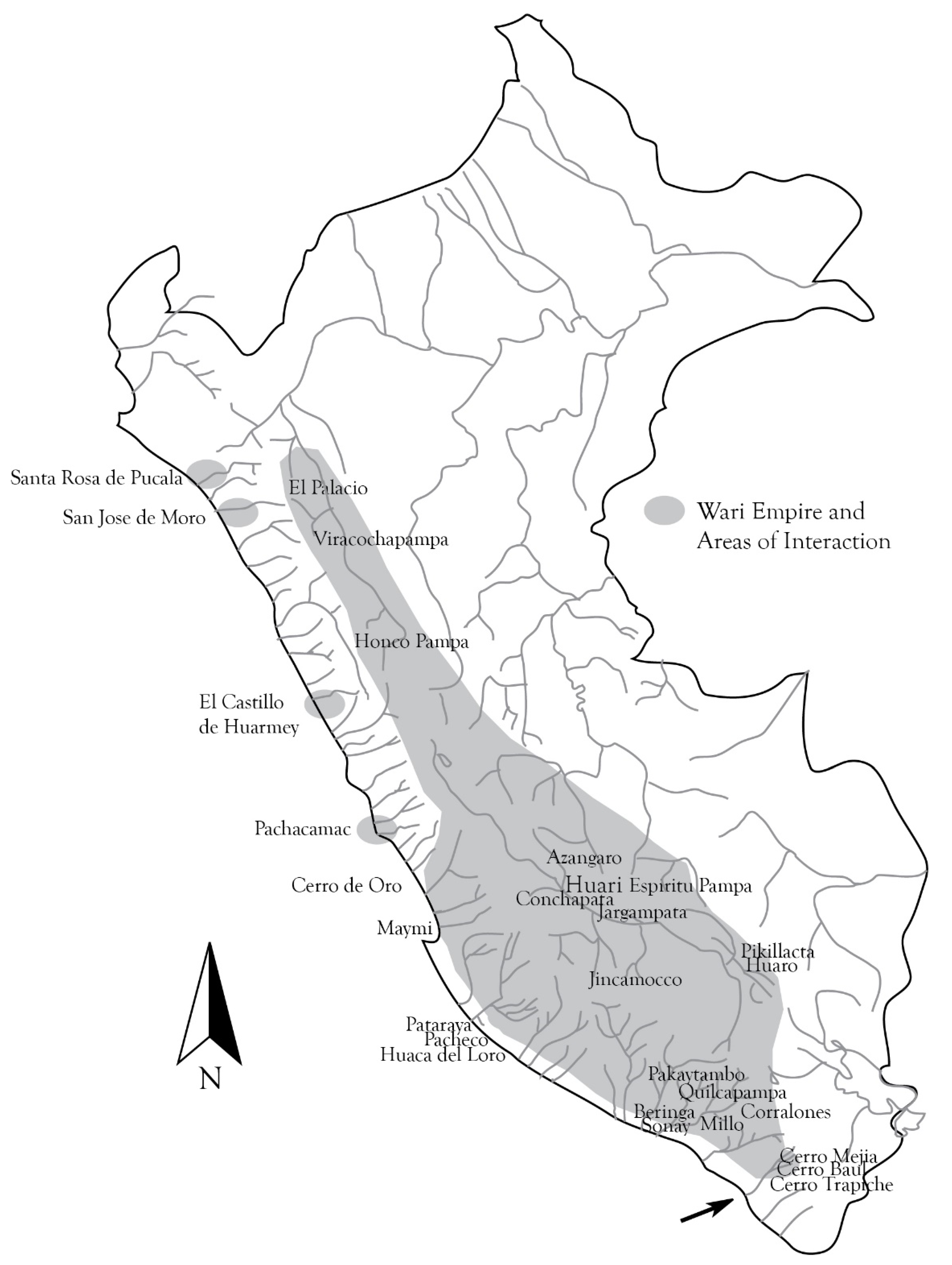
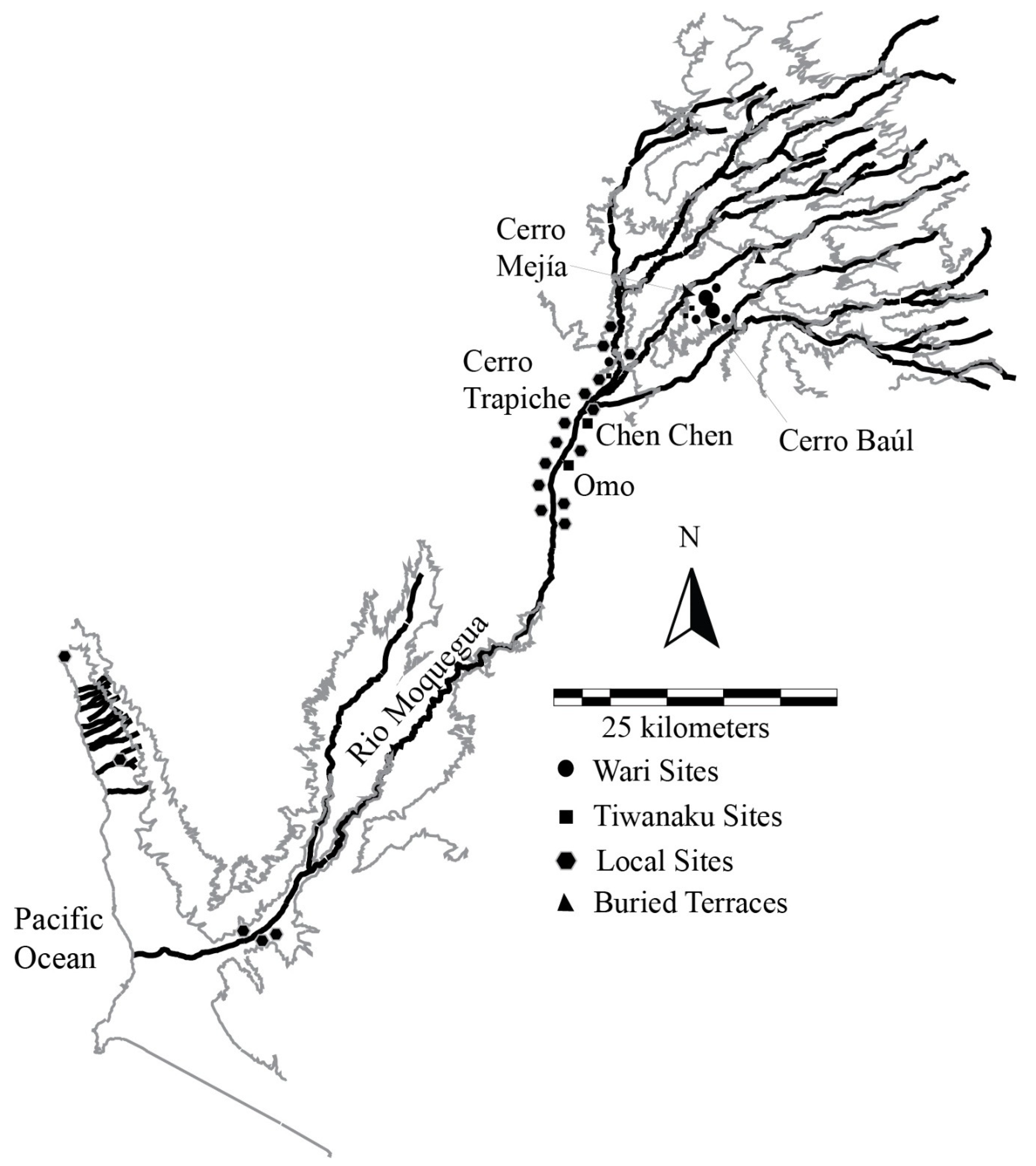
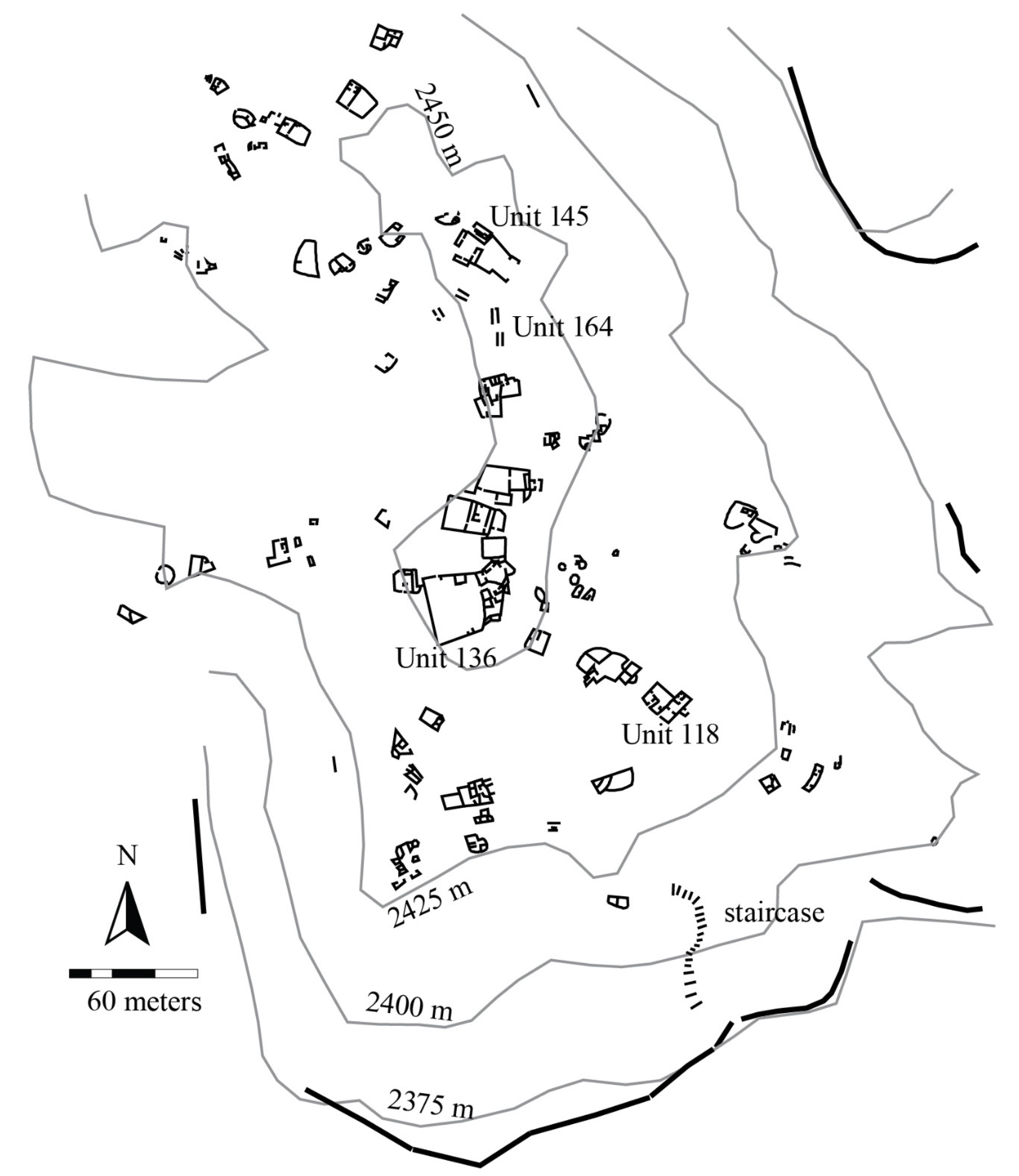
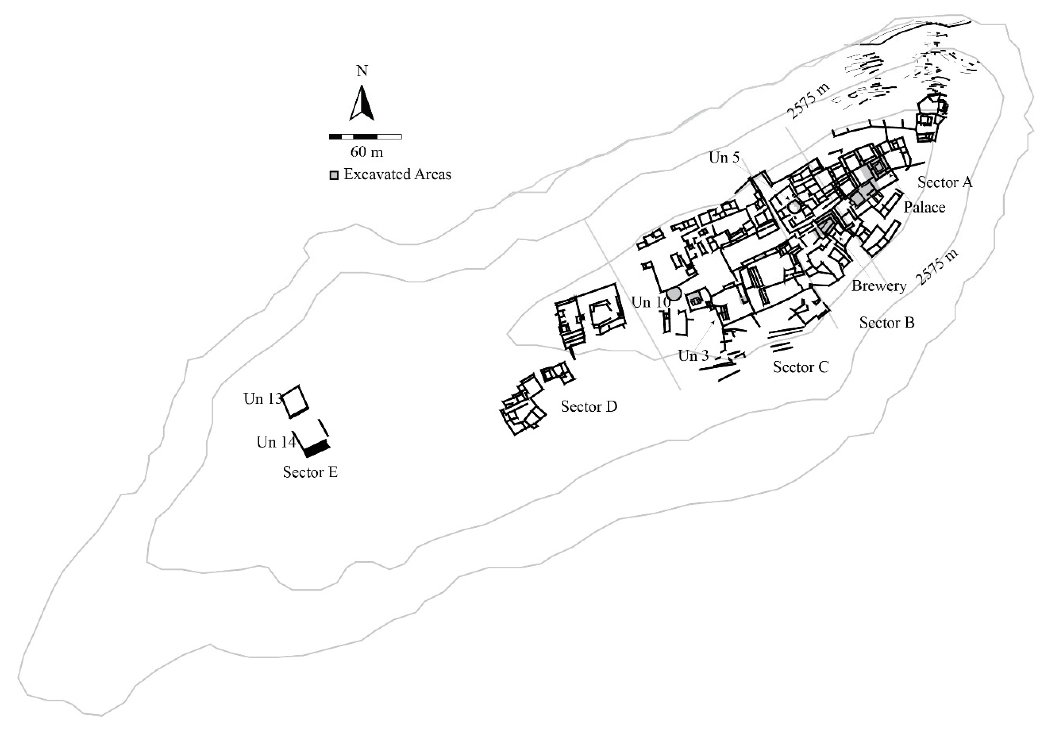
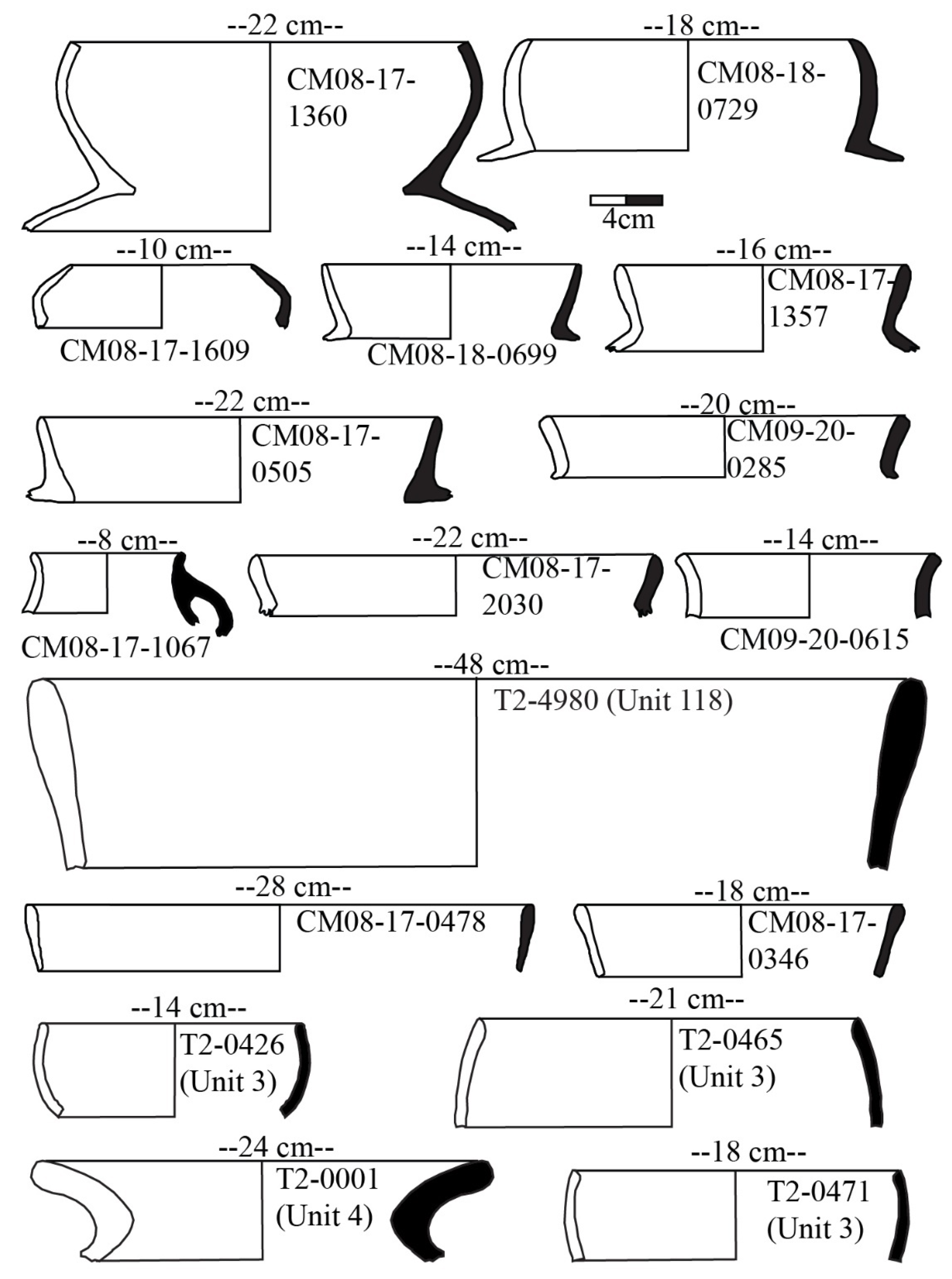
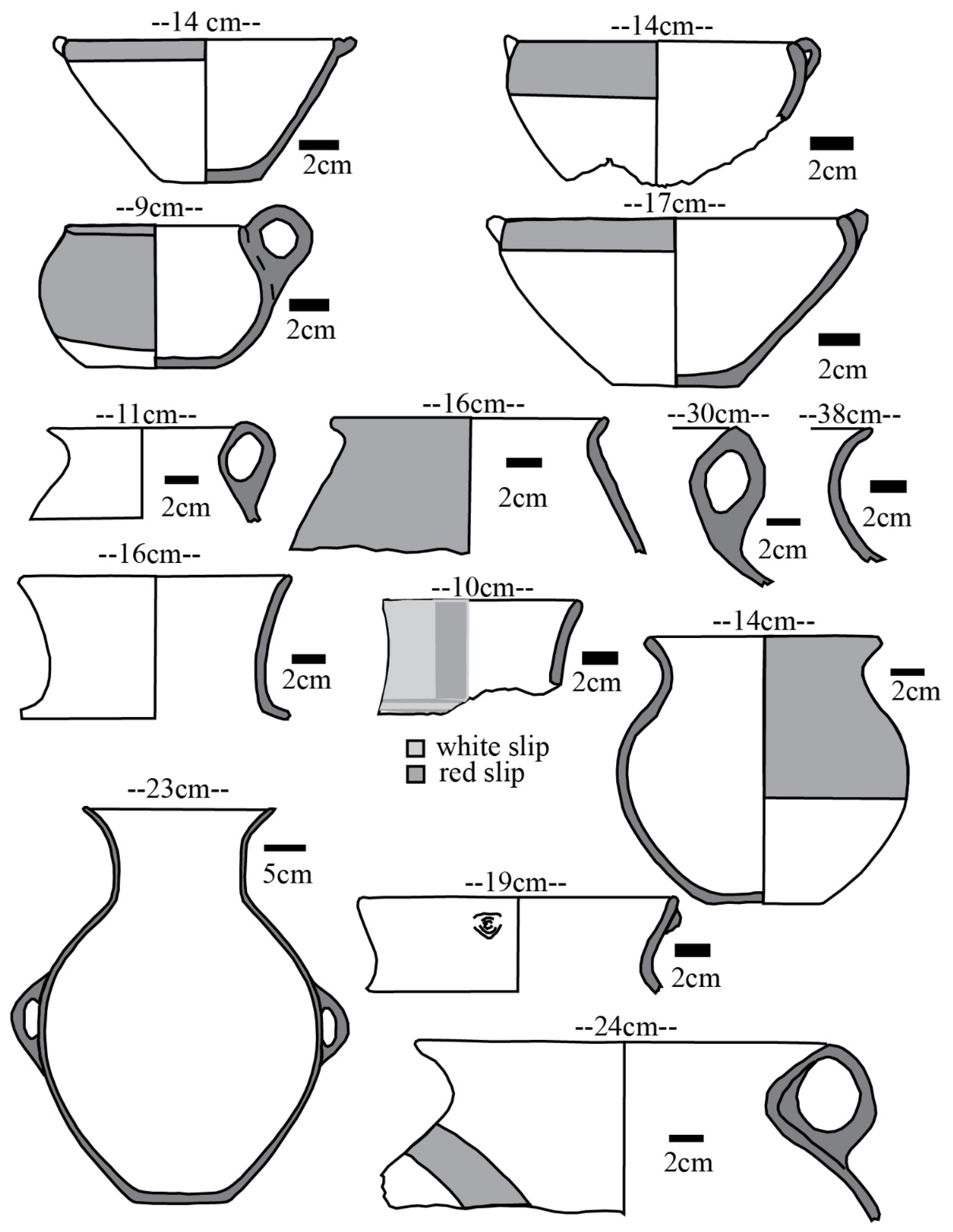
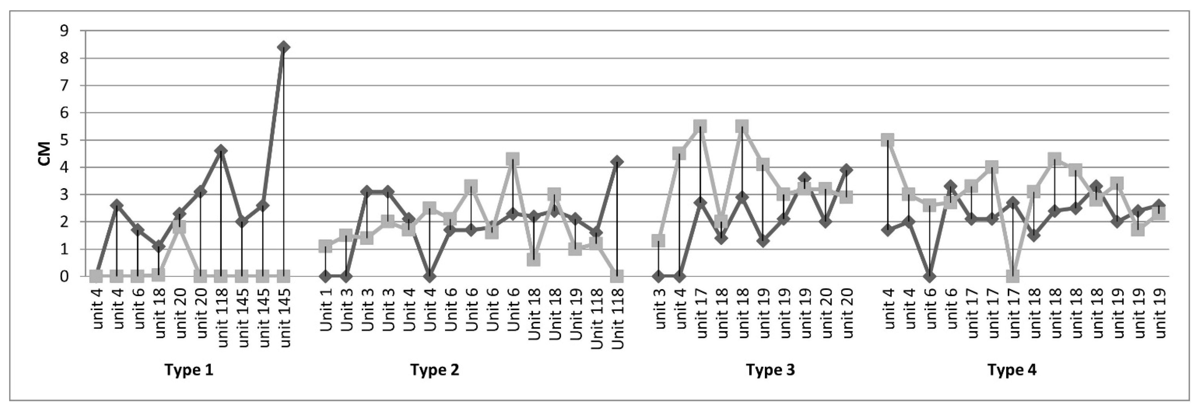
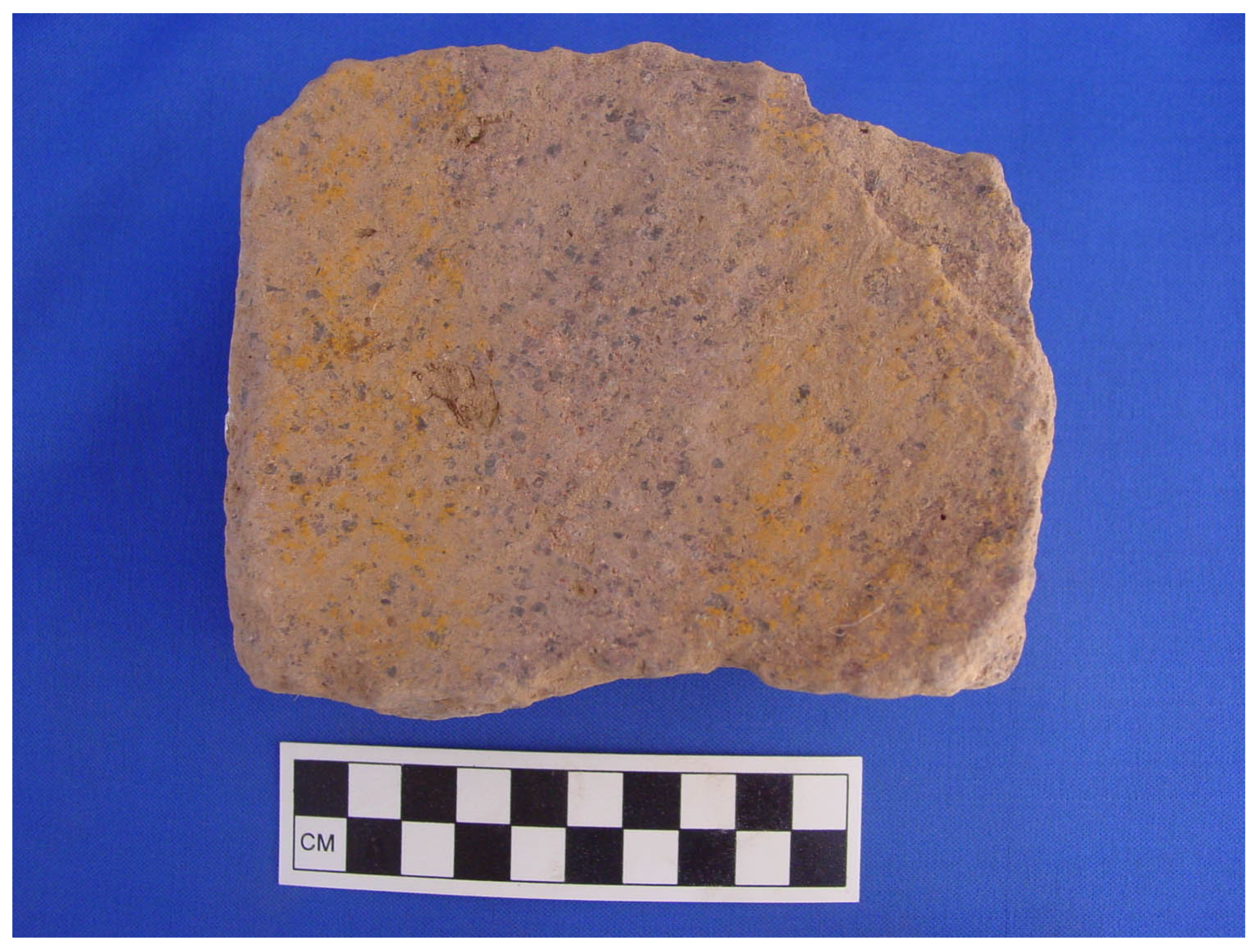
Table 1.
Radiocarbon dates from Cerro Mejía calibrated using Oxcal 4.4 with the ShCal20 calibration curve [30].
Table 1.
Radiocarbon dates from Cerro Mejía calibrated using Oxcal 4.4 with the ShCal20 calibration curve [30].
| Context | Uncal. BP | Lab Number | Specimen | Calibrated AD, 2 Sigma |
|---|---|---|---|---|
| Early Infrastructure | ||||
| Upriver Buried Terraces | 1551 ± 22 | D-AMS032575 | Carbon | 522–637 (94.4%) |
| Early Construction Activity at Cerro Mejía | ||||
| Un 20 | 1414 ± 36 | AA90354 | Carbon | 631–689 (69%) 738–773 (19.8%) |
| Un 17 | 1402 ± 38 | AA90350 | Carbon | 635–692 (60.2%) 733–774 (27.8%) |
| Un 19 | 1396 ± 36 | AA90353 | Carbon | 638–692 (58.3%) 734–774 (30.9%) |
| Un 18 | 1386 ± 36 | AA90352 | Carbon | 642–692 (50.4%) 700–773 (45.0%) |
| Un 18 | 1386 ± 37 | AA90351 | Carbon | 642–693 (49.6%) 699–773 (45.9%) |
| Un 18 | 1360 ± 36 | AA90357 | Carbon | 649–775, (95.4%) |
| Un17 | 1340 ± 43 | AA90349 | Carbon | 651–776, (82.6%) |
| Un 18 | 1333 ± 36 | AA90363 | Carbon | 658–776, (85.6%) |
| Un 4 | 1317 ± 29 | D-AMS032578 | Carbon | 671–777 (79.6%) |
| Un 145 | 1315 ± 29 | D-AMS032577 | Carbon | 673–777 (78.9%) |
| Peek Colonial Settlement | ||||
| Un 3 | 1313 ± 58 | AA41951 | Carbon | 656–888, 85.6% |
| Un 18 | 1300 ± 43 | AA90361 | Carbon | 675–883, 95.4% |
| Un 136 | 1293 ± 35 | D-AMS032576 | Burnt Corncob | 684–745 (44.5%) 784–875 (47.6%) |
| Un 136 | 1289 ± 41 | AA41956 | Carbon | 679–758 (37.3%) 766–886 (58.2%) |
| Un 145 | 1284 ± 54 | AA41952 | Carbon | 669–895 (93.2%) |
| Un 22 | 1272 ± 28 | D-AMS032583 | Carbon | 771–885 (78%) |
| Un 118 | 1269 ± 42 | AA41955 | Carbon | 680–753 (23%) 766–895 (70.5%) |
| Un 18 | 1269 ± 42 | AA90359 | Carbon | 680–753 (23%) 766–895 (70.5%) |
| Un 5 | 1268 ± 40 | AA41957 | Carbon | 682–749 (21.5%) 767–894 (72.7%) |
| Un 18 | 1248 ± 37 | AA90364 | Carbon | 771–897 (81%) |
| Un 18 | 1248 ± 34 | AA90360 | Carbon | 771–897 (84.7%) |
| Un 20 | 1242 ± 29 | D-AMS032581 | Carbon | 771–896 (89.7%) |
| Un 17 | 1242 ± 26 | D-AMS032580 | Carbon | 771–896 (89.7%) |
| Un 17 | 1227 ± 24 | D-AMS032579 | Carbon | 772–895 (89.7%) |
| Late Colonial Activity | ||||
| Un 20 | 1210 ± 29 | D-AMS032582 | Carbon | 771–821 (24.8%) 831–906 (38.3%) 917–974 (31.7%) |
| Un17 | 1152 ± 35 | AA90356 | Burnt Seed | 882–995, (90.2%) |
| Un 18 | 1143 ± 34 | AA90358 | Carbon | 887–995, (88.5%) |
| Cerro Petroglifo Construction Offering | 930 ± 35 | Beta371972 | Carbon | 1045–1090 (21.8%) 1102–1223 (73.6%) |
Table 2.
Correlates for determining the character of labor resources.
| Labor Resources: | Self-Sustained vs. State-Sustained | Local vs. Foreign Material Culture and Activity Patterns | Permanent vs. Temporary |
|---|---|---|---|
| Reducción | Self-sustained | Local | Permanent |
| Hatun Runa (m’ita) | State-sustained | Local or Foreign | Temporary |
| Mitamae | Self-sustained | Foreign | Permanent |
| Yanacona | State-sustained | Foreign | Permanent |
Table 3.
Percentage of pottery paste types by residential structure.
| Unit 1 | Unit 3 | Unit 4 | Unit 5 | Unit 6 | Unit 17 | Unit 18 | Unit 19 | Unit 20 | Unit 118 | Unit 145 | |
|---|---|---|---|---|---|---|---|---|---|---|---|
| N = 52 | N = 909 | N = 1005 | N = 257 | N = 229 | N = 3402 | N = 723 | N = 175 | N = 501 | N = 595 | N = 311 | |
| Paste 1 | 25% | 10.1% | 16.7% | 4.3% | 12.2% | 49.9% | 62.2% | 41.7% | 42.1% | 16.8% | 32.2% |
| Paste 2 | 36.5% | 6.4% | 6.4% | 47.5% | 38.9% | 5.5% | 13.4% | 20% | 15.2% | 13.1% | 5.8% |
| Paste 3 | 3.8% | 18.3% | 20.3% | 21% | 7.9% | 0.6% | 5.5% | 0.6% | 0.2% | 10.3% | 1.9% |
| Paste 4 | 7.7% | 12.1% | 16.5% | 5.4% | 2.2% | 2.1% | 3.3% | 0 | 0.2% | 5.4% | 2.3% |
| Paste 5 | 9.6% | 22.9% | 23.7% | 18.3% | 30.6% | 31.3% | 3% | 8 | 2.6% | 43% | 35.7% |
| Paste 6 | 0 | 10.1% | 7.5% | 3.5% | 2.6% | 9 | 10.4% | 25.7% | 36.5% | 6.7% | 1.9% |
| Paste 7 | 0 | 11.7% | 0.5% | 0 | 0.9% | 0.3% | 0 | 2.9% | 1% | 2.5% | 0.6% |
| Paste 8 | 17.3% | 1% | 6.9% | 0 | 0.9% | <0.1% | 0 | 0 | 0 | 0 | 0.3% |
| Paste 9 | 0 | 2.8% | 1.6% | 0 | 0 | 0 | 1.7% | 0 | 0 | 2% | 0 |
| Paste 10 | 0 | 4.5% | 0 | 0 | 2.2% | 0.7% | 0.4% | 1.1% | 2.2% | 0.2% | 19.3% |
| Paste 12 | 0 | 0 | 0 | 0 | 1.7% | 0.5% | 0 | 0 | 0 | 0 | 0 |
| 99.9% | 99.9% | 100.1% | 100% | 100.1% | 99.9% | 99.9% | 100% | 100% | 100% | 100% |
Publisher’s Note: MDPI stays neutral with regard to jurisdictional claims in published maps and institutional affiliations. |
© 2022 by the author. Licensee MDPI, Basel, Switzerland. This article is an open access article distributed under the terms and conditions of the Creative Commons Attribution (CC BY) license (https://creativecommons.org/licenses/by/4.0/).
Share and Cite
MDPI and ACS Style
Nash, D.J. Considering Imperial Complexity in Prehistory: A Polyethnic Wari Enclave in Moquegua, Peru. Humans 2022, 2, 104-137. https://doi.org/10.3390/humans2030008
AMA Style
Nash DJ. Considering Imperial Complexity in Prehistory: A Polyethnic Wari Enclave in Moquegua, Peru. Humans. 2022; 2(3):104-137. https://doi.org/10.3390/humans2030008
Chicago/Turabian StyleNash, Donna J. 2022. "Considering Imperial Complexity in Prehistory: A Polyethnic Wari Enclave in Moquegua, Peru" Humans 2, no. 3: 104-137. https://doi.org/10.3390/humans2030008