Article

The Development of a Hybrid Model for Dam Site Selection Using a Fuzzy Hypersoft Set and a Plithogenic Multipolar Fuzzy Hypersoft Set

1
Department of Mathematics, University of Management and Technology, Lahore 54770, Pakistan
2
Office of Research, Innovation and Commercialization, University of Management and Technology, Lahore 54770, Pakistan
3
Department of Computing and Mathematical Sciences, Cameron University, Lawton, OK 73505, USA
*
Authors to whom correspondence should be addressed.
Foundations 2024, 4(1), 32-46; https://doi.org/10.3390/foundations4010004
Submission received: 9 September 2023 / Revised: 21 November 2023 / Accepted: 19 December 2023 / Published: 3 January 2024
(This article belongs to the Section Mathematical Sciences)

Abstract

:
Inrecent years, there has been a notable increase in utilising multiple criteria decision-making (MCDM) methods in practical problem solving. The advancement of enhanced decision models with greater capabilities, coupled with technologies like geographic information systems (GIS) and artificial intelligence (AI), has fueled the application of MCDM techniques across various domains. To address the scarcity of irrigation water resources in Bortala, Northwest China, the selection of a dam site has been approached using a hybrid model integrating a multipolar Fuzzy set and a plithogenic Fuzzy hypersoft set along with a GIS. This study considered criteria such as a geological layer, slope, soil type, and land cover. Four potential and reasonably suitable dam locations were identified using a dam construction suitability map developed for Bortala. Ultimately, we showcased the benefits of the innovative method, emphasizing an open, transparent, and science-based approach to selecting optimal dam sites through local studies and group discussions. The results highlight the effectiveness of the hybrid approach involving a fuzzy hypersoft set and plithogenic multipolar fuzzy hypersoft set in addressing the challenges of dam site selection.

1. Introduction

Decision making identifies the problem, proposes alternatives to address identified problems, evaluates these alternatives, and finally selects the best option to carry out the offered solution [1,2,3,4]. Several multicriteria decision-making (MCDM) techniques are available, including the analytical hierarchical process (AHP) and the analytical network process (ANP) [5], data envelopment analysis (DEA), the technique for order of preference by similarity to ideal solutions (TOPSIS) [6], fuzzy decision making [7], and intuitionistic fuzzy sets (IFSs) [8]. Saeed et al. [9,10,11] worked on solid waste management strategies, the evaluation of strategic procurement techniques for fuel cell and hydrogen components, tuberculosis disease prognosis, and proposed potential treatment methods.
Water is precious and essential for human survival and progress in agriculture, sanitation, and the economy. Both temporal and regional disparities in water availability have contributed to simultaneous floods and drought in different places on the planet. Case studies involve floods in Southeast Spain in 1997 [12], droughts in Papua New Guinea (PNG) in 1997 [13], floods in South France in 2003 [14], and droughts in South Africa in 2003 [15], as well as, of course, floods in the Northeast Iberian Peninsula in 2000 [16] and droughts in the Amazon River basin in 2005 [17].
China’s ability to store total freshwater resources is massive, around 2.8 trillion m 3 , ranking it sixth in the world [18]. However, according to the Ministry of Water Resources (MWR), resources of fresh water per capita in China are 2100 m 3 , which is 28 % of the global average and far below the per capita average number (7831 m 3 ). As a result, the lack of water remains a major issue in China, particularly in Northwest China, which covers large areas of arid regions. China accounts for 33% of the total land area comprising six regions, but it only accounts for 74 % of total water resources. Furthermore, Northwest China is one of the essential glacier and snow field areas, with the largest glacier and surface area of 1.74 km 2 located here [19]. Many freshwater resources are solidified and difficult to utilize, inflaming the water resources in Northwest China. Previous studies have shown that Northwest China has one of the world’s highest water resource pressures. The Budyko aridity index (BAI), which measures climate dryness, is greater than 3.0 in this province, revealing that it is one of the world’s driest basins [20]. Annual precipitation in Northwest China ranges from 40 mm to 600 mm [21,22], with an annual potential evaporation of 1500–3000 mm [23]. As a major wheat- and cotton-producing region, this area spends 41.58% of its entire water consumption on agricultural irrigation, despite its low precipitation and high evaporation [24]. Irrigation water supply is crucial for economic development and food security in Northwest China. Xinjiang Uygur region, the largest province in China, relies solely on irrigation to advance its agricultural sector [25]. According to a study conducted from 1989 to 2010, [26], the months with the greatest temporal variation in demand for irrigation water are July and August. When comparing water availability and demand, the most crucial stage of water supply occurred between April and May from 1989 to 2010.
On the other hand, humans find it extremely difficult to change the total volume of available freshwater. Efforts to improve the efficiency with which water is used may be a viable option. Dam construction is one of the most common methods for achieving the goals above because it collects and redistributes water for application fields such as irrigation, domestic consumption, industrial use, and aquaculture, but it also generates electricity via hydropower. Knowing whether or not the Chinese government endorses water initiatives like dam building is crucial because of the government’s outsized influence in the country. The Ministry of Water Resources (2014) states that from 2008–2014, the Chinese government invested CNY 108.82 billion on hydrological projects, rising to CNY 408.31 billion in 2014. Local and federal governments together accounted for 88.4% of all spending in 2014. Thus, the Chinese government considers managing water resources crucial. The government also promotes dam construction in appropriate locations in response to water usage demand. Aside from Chinese government support, water resource availability is an essential priority for dam construction. In terms of precipitation amount, the environment is becoming more appropriate for groundwater harvesting as precipitation in Northwest China has enhanced over the last 50 years (Ref. [27]), and forecasting for future precipitation under different scenarios has also increased in Northwest China [28].
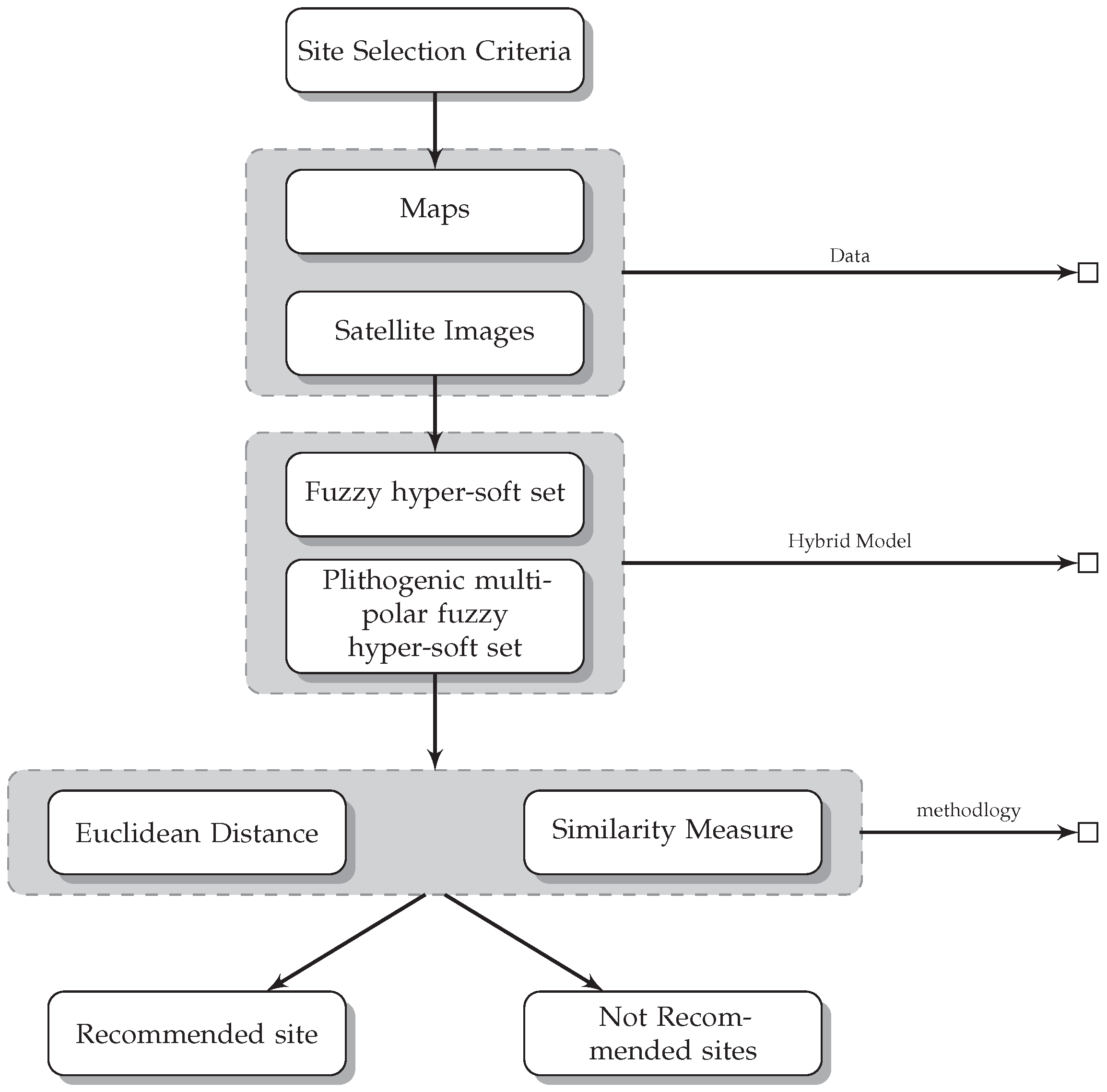
The biggest challenge for any organization is to identify potential dam locations. To assist decision makers in selecting the ideal location for a dam, we developed a hybrid model for dam site selection using a fuzzy hypersoft set and a plithogenic multipolar fuzzy hypersoft set. The considered hybrid method is more efficient and less time-costly. Professionals and researchers can use this methodology for other complex phenomena more quickly and efficiently.
Zadeh [29] proposed fuzzy sets as additional data of classical type. The concept of a theory of fuzzy sets has numerous applications. Domains with insufficient or incomplete information, such as members of a set, are permitted in bio-informatics fuzzy set logics to have a moderate view of membership, as explained by the actual unit interim [0, 1]. The membership function was admired. Molodtsov introduced the soft set [30] as a mathematical technique for dealing with uncertainties that are free of the issues that have plagued existing theoretical approaches to dealing with uncertainties. Soft set theory research is advancing at a rapid pace right now. Chen [31] investigated the concept of fuzzy set similarity measure, which Maji et al. [32] found to be ineffective in trading a parametric model with unpredictability. He discovered strains and issues in mathematical representations and proposed a soft set theory to address the problems. Saeed et al. [33] explained a fuzzy soft set with its application in multiattribute decision making. The authors of [34] introduced the concept of intuitionistic fuzziness, which also plays an important role in the fuzzy soft set. The authors of [35] proposed using fuzzy numbers in the mobile selection. Saeed and Majid [36] developed a hybrid model for donations to deserving and right candidates using a multipolar interval-valued neutrosophic soft set. Abdel-Basset [37,38] has written articles on medical disease diagnosis using a neutrosophic imaging environment. Alamri et al. [39] worked on the hybrid entropy-based economic evaluation of hydrogen generation techniques using multicriteria decision making. Jafar et al. [40] worked on distance and similarity measures using max–min operators of neutrosophic hypersoft sets with applications in site selection for solid waste management systems. The authors of [41,42,43,44] produced several interesting results in the framework of generalized fuzzy sets and presented several applications on multicritera decision making.
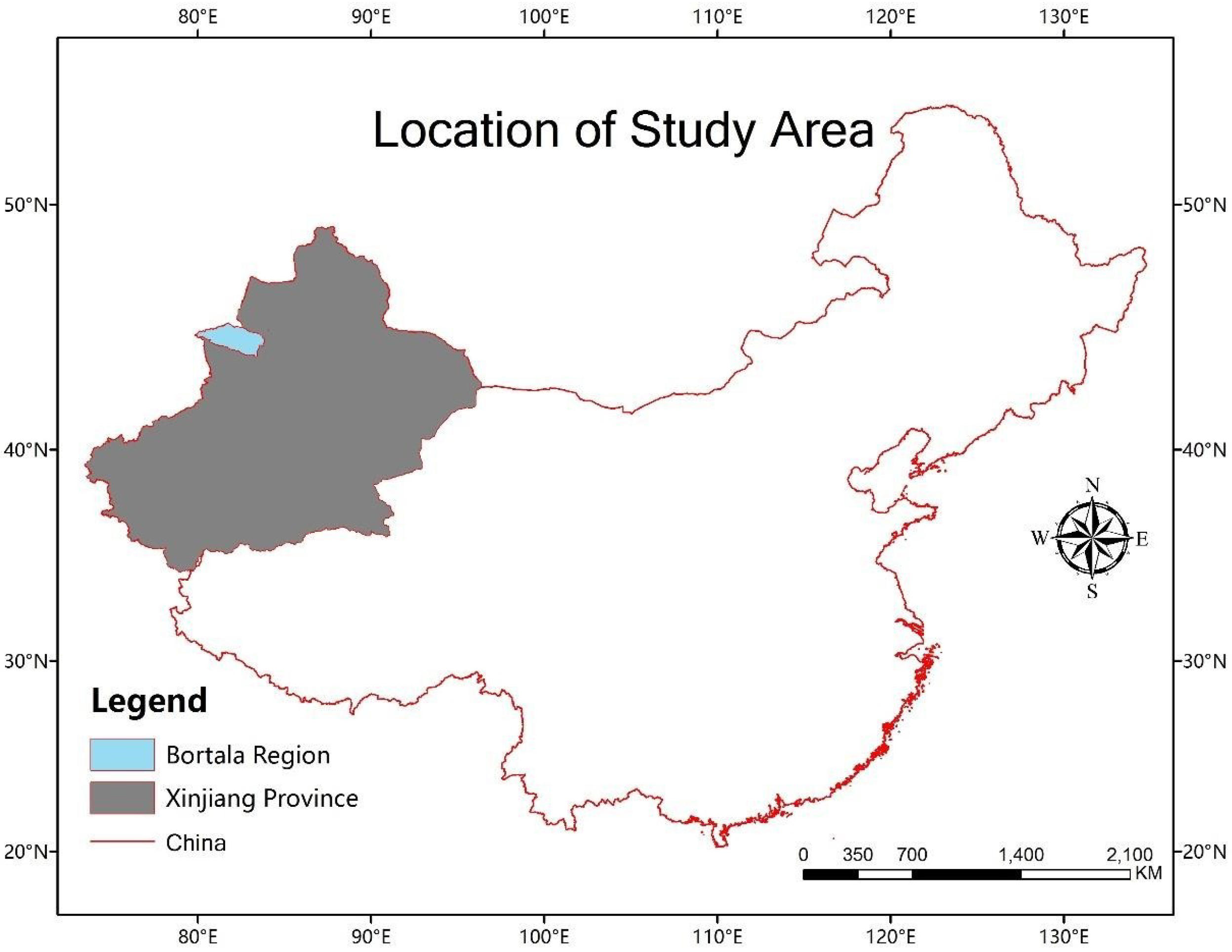
However, due to its size, Northwest China’s geography can only be characterized through extremely large data sets, which may take too long to process. Therefore, the Bortala region in Northwest China, a more manageable area of about 25,000 km 2 , was selected as the subject location for this investigation.

1.1. Aim of this Study

This article aims to identify potential dam locations in the Bortala region of Northwest China to assist decision makers in determining the best location for a dam(s). The environmental circumstances will largely determine the best locations for dams and the irrigation water supply as their primary purpose. In addition to the study’s main goal, several other goals must be met:
  • The construction of a suitability map based on the feasibility of building a dam using several parameters.
  • The suggestion of places that would make good dams.
  • Computing cross sections and other properties, such as reservoir volume, dam height, and dam breadth, of potential dam locations.
  • A hybrid of a fuzzy hypersoft set and a pathogenic multipolar fuzzy hypersoft set being applied to the problem of choosing a dam.

1.2. Research Area

The study area is the Bortala Mongoll (Bortala for short) and Xinjiang Uygur (Xinjiang for short). Northwest China has an area of approximately 27,000 km 2 and a population of 0.4 million. Figure 1 represents the location of the research area.
Bortala is located in the Jungar Basin of the southwestern section, between two mountain ranges: the Northwest Bortala and the Southwest Bortala. Bortala is a border area in Northwest China, as illustrated in Figure 1. It shares a 385 km international border with Kazakhstan to the west and north (Wikipedia 2016). Inside Bortala are two big closed lakes: Sayram lake with fresh water and Ebi-Nur Lake with salt water.
According to the Köppen–Geiger climate classification (Climate-Data.Org 2016), Bortala has an arid climate, also known as a desert climate. Furthermore, 271 of the 431 cities in Xinjiang Province have desert climate records (Climate-Data.Org 2016), indicating that desert climate is the dominant climate type in the province. As a result, the weather in Bortala is typical of Xinjiang Province. Bortala’s average annual temperature has been 7.4 C since 1982, and the average precipitation has been 192 mm (Climate-Data.Org 2016). According to research on climate change from 1960 to 2006, the annual temperature of Bortala prefecture climbed from 1960 to 2006 [45], and the amount of precipitation in the prefecture enhanced and has been growing since 1980 [46].
Approximately 54% of the prefecture’s agricultural output comes from cotton fields near Bortala. Research conducted in the dry region of Northwest China between 1989 and 2010 found that the demand for irrigation water increased throughout the study, primarily due to an increase in cotton-cultivated areas requiring more irrigation water than other crops [26].

1.3. Literature Review

The application of any multicriteria decision-making (MCDM) method begins with formulating a decision matrix that represents the performance of alternatives concerning a set of conflicting criteria. Despite over 30 (MCDM) tools, prior researchers in decision-making problems, such as dam site selection, have provided concise introductions to some of these methods. The mathematical formulations of the different (MCDM) tools are available in [47,48,49]. Real-world decision making is often challenging due to the complexity of reality, and (MCDM), designed to handle decisions in the presence of conflicting criteria [50], emerges as a viable solution. The location of a dam is a challenging subject since it impacts and influences a wide range of environmental and societal elements. Dams, on the other hand, can be built for a variety of causes, resulting in a greater range of factors and effects. Numerous publications have been published on the topic of the dam site, employing multiple criteria and measuring the effects of each criterion using diverse approaches.
Lee et al. [51] presents a model for addressing multicriteria decision-making problems. The proposed model integrates the fuzzy analytic network process (FANP) and fuzzy goal programming (FGP). FANP allows for the consideration of diverse factors in China. A water-saving ecological check dam site optimization model (WCSOM) was created, incorporating novel water-saving factors. This model was then utilized to optimize the selection of check dam sites in the Sijiagou Basin, China [52]. In 2013, in central Iran, research was carried out to determine the optimal places for underground dams that store groundwater beneath the surface in conjunction with aqueducts using a geographic information system (GIS) [45]. In the same study region [53], the same research team created and executed a decision-making system of support for the selection of dam sites that includes the fuzzy (AHP) and (VIKOR) technique for (MCDM) in 2015. In Western Iran, site selection of a dam and comparative study of the (AHP) and (TOPSIS) [54] were conducted. A study was conducted in Northwest Saudi Arabia to determine the best dam location using a combination of (GIS) and (RS) techniques [55].
The four parameters employed in the Northwest Saudi Arabia example to establish the ideal dam site location were the catchment slope, land cover type, soil types, and rate of soil infiltration [56]. In Western Iran, the nine types of criteria and eleven subcriteria are recognized as the most important aspects for identifying the dam site [57].
In the Western Iran instance from 2015, 18 parameters were analyzed for the better dam site decision, resource access, economic growth, and overall cost, with dam site health, annual yield, topography, facility development, economic growth, water quality, dam body and reservoir damage, river flow regime, reservoir volume, water diversion and transfer, the annual volume of sediment, the likelihood of dam break, the likelihood of average annual evaporation, social impacts, environmental impacts, maximum flood, and political impacts all taken into account. Even if all of the research, as mentioned earlier, concentrates more on the features of dam construction, some studies focus more on the repercussions of dam construction. The surface area of the reservoir, time that water is held in the reservoir, river length impounded, river length left dry, biomass flooded, number of the downstream tributaries, access roads through the forests, likelihood of reservoir stratification, people requiring the relocation, and critical natural habitats impacted are all examples of such indicators. This list was taken from a research paper published in 2003 [58].
Since the goals of decision makers might range from high consumption (as in the case of the Three Gorges Dam) to very low usage (as in the case of irrigation or aquaculture in very small towns), it is challenging to specify a set of criteria for selecting a dam site in general. Meanwhile, local factors regarding the environment and human civilization and decision makers’ preferences for speedy or sustainable development create problems in a wide range of dam site selection criteria. However, some conditions and fundamental guidelines exist for secure dam construction, such as hydrology and slope.

1.4. Multicriteria Decision Making

Making decisions in the real world can be challenging due to the complexity of reality. Multicriteria decision making (MCDM) is a potential solution, addressing decision-making challenges when eligibility criteria often conflict with each other [59]. The 1950s and 1960s saw the development of the most recent MCDM foundations. The initial suggestion for the (MCDM) abbreviation appeared in the late 1970s [60]. Complex issues can be broken down into smaller, simpler components that are easier to measure or appraise utilizing (MCDM). There is no single (MCDM) approach that can be applied step by step. Instead, many other approaches to (MCDM) are suggested. The fuzzy hypersoft set and plithogenic fuzzy hypersoft set are the most prevalent in making decisions.

1.5. Structure of Paper

Basic mathematical definitions related to the proposed study are revised in Section 2. Section 3 deals with a case study problem corresponding to the desired situation. The article’s conclusion and future work are depicted in the Section 4.

2. The Preliminaries

In this section, some important definitions related to this article are given.

2.1. Soft Set

Ref. [61]: Consider a universal set S ; a set of the attributes of elements E is in S . The subset Y of E is defined by a function F as
F : Y P ( S ) ,
Then, the pair ( F , Y ) is stated as a soft set over S , i.e.,
( F , Y ) = { [ e , F ( e ) ] : e Y , F ( e ) P ( S ) }

2.2. Hypersoft Set

Ref. [61]: Let S be a universal set; P ( S ) is a power set of S . Let t 1 , t 2 , ⋯, a k , for k ≥ 1 be distinct k attributes; the corresponding attribute values to the sets are T 1 , T 2 , ⋯, T k , with T i   T j = Ø , for ji, and j, i  ∈ 1, 2, 3, ⋯, k. Then, pair ( F , T 1 × T 2 × ⋯ × T k ), where T 1 × T 2 × ⋯ × T k P ( S ) is called a hypersoft set over P ( S ) .
Example 1. 
Let E = { e 1 , e 2 , e 3 , e 4 } and set M = { e 2 , e 4 }    E . Let the attributes be x 1 = size, x 2 = color, x 3 = gender, x 4 = nationality, and values of their attributes, respectively:
Size = X 1 = {short, medium, tall}, color = X 2 = {white, brown, black}, gender = X 3 = {male, female, transgender}, nationality = X 4 = {Japanese, Nigerian, Pakistani, Chinese}. Let the function be: F : X 1 × X 2 × ⋯ × X n P ( E ) . Let us suppose the following: F (short, brown, female, Nigerian) = { e 2 , e 4 } . With respect to set F , one has.

2.3. Fuzzy Hypersoft Set

Ref. [61]: F (short, brown, female, Nigerian) = { e 2 (0.4), e 4 (0.8)}, which indicates with regards to the attribute values {short, brown, female, Nigerian}, all together, that e 2 belongs 40 % to the set M ; similarly, e 4 belongs 80 % to set M .

2.4. Plithogenic Hypersoft Set

Ref. [61]: The crisp, fuzzy, hypersoft, neutrosophic, and intuitionistic fuzzy frameworks have evolved into the Plithogenic hypersoft set. In this paradigm, the degree of belongingness of an element e 2 to the set M is determined by considering all attribute values (short, brown, female, Nigerian) in combination, resulting in a collective degree of belongingness regarding a set of attribute values. The Plithogenic hypersoft set incorporates elements from all the frameworks mentioned above. This is because the degree of belongingness of an element x to the set M regarding any single attribute value could be the crisp, hypersoft, fuzzy, neutrosophic, or intuitionistic fuzzy set.

2.5. Plithogenic Fuzzy Hypersoft Set

Ref. [61]: The degree to which an element e belongs to the set M with regard to each attribute value is as follows: fuzzy: d e 0 ( a ) P ( [ 0 , 1 ] ) , the power set of [0, 1], where d e 0 (a) may be hesitant; the subset; an interval; a single-valued number; the hesitant set, etc. A considered example for a single-valued number is as follows: F({short, brown, female, Asian}) = { e 2 (0.4, 0.7, 0.6, 0.5), e 4 (0.8, 0.2, 0.7, 0.7)}.

2.6. Plithogenic Two-Polar Fuzzy Hypersoft Set

Ref. [61] In a plithogenic two-polar fuzzy hypersoft set, the degree of appurtenance of an element e to the set S is two and fuzzy for each attribute. d e 0 ( a ) P ( [ 0 , 1 ] ) , the power set of [0, 1], where d e 0 (a) may be an interval, single-valued number, the hesitant set, a subset, etc. In the considered example, for a single-valued number: F{(medium, short), (white, brown) (male, female), (Pakistani, Nigerian)} = e 2 { ( 0.4 , 0.2 ) , ( 0.7 , 0.1 ) , ( 0.6 , 0.7 ) , ( 0.2 , 0.5 ) } , e 4 { ( 0.4 , 0.1 ) , ( 0.4 , 0.1 ) , ( 0.5 , 0.7 ) , ( 0.2 , 0.5 ) } .

2.7. Plithogenic Multi-Polar Fuzzy Hyper Soft Set

In this set, the degree of belongingness of an element e to the set M exceeds two and is Fuzzy, with respect to each attribute: d e 0 ( a ) , P ( [ 0 , 1 ] ) , the power set of [ 0 , 1 ] m , where d e 0 ( a ) may take various forms such as a single-valued number, an interval, a subset, a hesitant set, and so on. As an example, let us consider a single-valued number: F { [ s i z e ] m , [ c o l o r ] m , [ g e n d e r ] m , [ n a t i o n a l i t y ] m } = { e 2 {( e 1 ( z ) , e 2 ( z ) , , e m ( z ) ), ( e 1 ( z ) , e 2 ( z ) , , e m ( z ) ), ( e 1 ( z ) , e 2 ( z ) , , e m ( z ) ), ( e 1 ( z ) , e 2 ( z ) , , e m ( z ) )}, { e 4 {( e 1 ( z ) , e 2 ( z ) , , e m ( z ) ), ( e 1 ( z ) , e 2 ( z ) , , e m ( z ) ), ( e 1 ( z ) , e 2 ( z ) , , e m ( z ) ) } } } , where the i -th mapping is described as follows:
E i : [ 0 , 1 ] m [ 0 , 1 ] ,

2.8. Distances

Ref. [62]: Suppose Z = { z 1 , z 2 , , z n } is the universal set and E = { e 1 , e 2 , , e k } is the set of attributes. The distance between Z and E can can be calculated:
  • The Hamming distance [62]:
    d H ( Z , E ) = 1 n { Σ i = 1 n Σ j = 1 k | p i o Z ( z k ) p i o E ( e j ) | }
  • The normalized Hamming distance [62]:
    d H ( Z , E ) = 1 m q { Σ i = 1 n Σ j = 1 k | p i o Z ( z k ) p i o E ( e j ) | }
  • The Euclidean distance [62]:
    d H ( Z , E ) = { 1 n Σ i = 1 n Σ j = 1 k ( p i o Z ( z k ) p i o E ( e j ) ) 2 } 1 2
  • The normalized Euclidean distance [62]:
    d N E ( Z , E ) = { 1 n k Σ i = 1 n Σ j = 1 k Σ k = 1 m ( I T X i ( e j ) ( z k ) I T Y i ( e j ) ( z k ) ) } 2
  • The similarity measures [62]:
    The similarity measures of two sets Z and E can be calculated as,
    S ( Z , E ) = 1 1 + d ( Z , E )

3. Application in a Recognition Problem

In this part, we apply the idea of a distance-based similarity measure to the data from a hybrid of a fuzzy hypersoft set and a plithogenic multipolar fuzzy hypersoft set to tackle the problem of pattern identification.

3.1. Factors Influencing Dam Siting

Factors are crucial in the site selection process, influencing the outcome from various perspectives. An extensive review of numerous studies revealed certain commonalities and characteristics in selecting factors for dams. Despite the variations in natural and social environments and the intended purpose, there are identifiable similarities in the considerations taken into account during the site selection process.
The decision makers’ objectives exhibit a broad range, making it challenging to establish a standardized set of criteria for dam siting. The factors influencing decisions vary depending on the dam’s purpose, ranging from large hydroelectric power generation dams, exemplified by the world-leading Three Gorges Dam, to smaller dams intended for irrigation and aquaculture. The diversity in dam objectives underscores the need for a flexible and context-specific approach in considering decision factors for dam siting. According to the latest data from the ICOLD 2020 statistics (Table 1) [63], irrigation is a major purpose, accounting for 47% and 24% of dams’ sole-purpose and multiple-purpose statistics, respectively. The next three major purposes are hydropower, water supply, and flood control.

3.2. Criteria Selection

Based on a review of prior research, the specific characteristics of the Bortala region, and data availability, four criteria were chosen for this study: soil type, land cover slope, and geological layer resistance. Precipitation is the primary source of runoff water replenishment. In other words, precipitation has a beneficial impact on runoff volume. As a result, when no natural calamity is induced by excessively high precipitation, such as floods or landslides, precipitation favors dam function. The slope is one of the most important factors influencing dam safety, as it raises the risk of landslides and brings additional strain on building foundations. Soil types can be classified based on texture, resulting in different soil penetration rates. As a result, soil type impacts dam function in the sense of runoff volume. Another factor influencing dam protection is the geological layer’s high resistance, determined by the geological layer’s rock type. Because this research focuses on dams that provide agricultural irrigation, converting farmland into dam-building land is less important than building dams on shrub or forest cover.

3.2.1. Soil

The term environment encompasses a broad spectrum of factors. Our study specifically considered environmental criteria, including soil-related aspects (such as soil type and erosion), land-use patterns, proximity to water resources, and groundwater availability. It is important to note that these chosen criteria do not cover all environmental considerations; rather, they represent commonly utilized factors in the existing literature. Land use and soil type exhibited the highest prevalence among these criteria, with 88% and 54% utilisation rates, respectively.
Soil types can be categorized based on texture, influencing soil infiltration rates and impacting runoff volume. It is advisable to consider sufficiently water-resistant fine-grained foundations, clays, and clay mixtures [64]. The choice of soil type becomes crucial in managing and controlling runoff, and selecting properties conducive to water resistance can be advantageous.
Bortala’s soil properties are extracted from a 2012 worldwide soil properties image. This region has 11 different types of soil qualities. The classes are identified by the global distinct SOTER code, which may be used to search for the % mass of the components: sand, clay, and silt. Simple classification is used to trace the varied soil infiltration in the study region based on the different percentages of these three soil types. Bortala’s four soil types are categorized based on their composition and a textural triangle that describes the relative amounts of sand and clay in different types of soils and basic infiltration rates for different types of soil [65]. The four soil types are sand, loam, sandy loam, and clay loam. Based on basic infiltration for rates of each soil type, which can be found in Table 2, the soil types are allocated preference values for dam construction in Table 3.

3.2.2. Slope

Elevation and slope are key criteria reflecting topographic features. Typically, regions with moderate elevation are considered more suitable for dam construction than areas with lower or higher elevations, which are generally deemed less suitable [67]. However, there is divergence among researchers regarding the suitability of steep slopes versus moderate slopes for dam construction as in Table 4.
Natural structures with an optimal river valley morphology are uncommon, necessitating the adaptation of different dam types to varying river valley shapes. Earthfill dams are well-suited for wide valleys, gravity dams for narrow sites, and arch dams for even narrower locations. The appropriateness of the slope is intricately linked to the dam’s intended purpose. For rainwater harvesting, the Food and Agriculture Organization (FAO) suggests that the slope should not exceed 5%. In the placement of check dams, the slope plays a crucial role in determining reservoir capacity and sedimentation, with steeper slopes often leading to increases.
There are two ways to describe slopes. The slope measures the inclination of the ground relative to the horizontal plane. The other is the percentage slope, quantifying the landscape’s relative vertical and horizontal changes. The Pythagorean theorem can generate a slope based on a DEM. In previous studies, different slope thresholds were chosen for dam construction, such as less than 10%, which equals 5.71 degrees [68]. The slope is classified into four classes in this study, with each 1 degree less than or equal to 5 degrees representing one category, and a slope higher than 5 degrees representing another. Table 5 displays the classes and preference values.

3.2.3. Geological Layer

The geological conditions at a dam site are paramount, as they directly impact the safety and stability of the project. Furthermore, the geological foundation of the site plays a crucial role in determining the type of dam and the materials used in dam construction. The site must possess impermeable geological characteristics, ensuring a secure dam foundation without leakage. For instance, in regions with a typical karst landscape, like Southwest China, the lithology directly influences whether water will “leak away” after the dam is constructed [69]. Key geological-related indicators encompass geology/lithology, tectonic zones, distance to faults, and proximity to lineaments.
In the examination of analyzed papers, it was observed that 60–70% opted for one or two geological factors. However, Othman [67] took a more comprehensive approach by considering four geological factors: tectonic zones, lithology, distance to lineaments, and faults. Tectonic zones deemed less suitable, such as the imbricated zone and the high folded zone, are characterized by geological weaknesses represented by faults and lineaments. These geological features are typically avoided in buffer zones, emphasizing the pivotal role of geological resistance in selecting dam sites as in Table 6.
No natural elements influencing dam construction are more important than geological ones. According to a compilation of dam performance statistics and foundation, problems are the most frequently occurring reasons for dam failure [70]. Competent rock foundations are resistant to erosion, percolation, and pressure. Table 7 displays the preference values for each class.

3.2.4. Land Cover

Variations in social contexts result in differences in socioeconomic criteria for site selection. Proximity to roads and settlements, which reduces transportation costs, was utilized at a rate of 32%. Distances to material facilities, roads, cities, and villages are considered to assess construction cost implications. Distances to the countryside and cities represent distinct scenarios, often requiring a specific distance from the city while aiming to be as close to the countryside as possible. This is because rural areas can provide the necessary labor force, while maintaining a certain buffer zone within the city is essential to prevent significant accidents like dam failures [71].
Land cover influences dam site selection in numerous ways. For starters, land cover considerably alters the effect of the rainfall, giving land cover a role in influencing soil destruction [72], and a high soil destruction area creates a poor foundation for dam construction [73]. On the other hand, dam construction results in land expropriation, which has varying economic costs depending on land cover type. In this study, the land cover is classified into four major groups, as shown in Table 8, based on the preference for dam construction. Furthermore, a Boolean categorization excludes dam locations on water or settlements. Table 9 displays the preferred values for land cover classes.

3.3. Problem of Selection of Dam Site: Hybrid of Fuzzy Hypersoft Set and Plithogenic Multipolar Fuzzy Hypersoft Set

Algorithm of the Problem:

Step 1: Constructing a set of attributes for selection purposes involves defining a set denoted as E = { U 1 , U 2 , , U q } .
Step 2: Building a set R representing the requirements of an organization for dam selection involves identifying and defining the essential criteria and conditions that the selected dam must meet.
Step 3: Building a hybrid of a fuzzy hypersoft set and a plithogenic multipolar fuzzy hypersoft set with the help of evaluating various alternatives given by the decision-making team.
Step 4: To determine the distance between S i and R , utilize the distance formula.
Step 5: The similarity measure S M ( R i , N ) between S i and R can be calculated using a similarity measure formula.
Figure 2 displays the Selection Algorithm for dam site selection, demonstration of the application of the pattern recognition problem to the selection of a dam can be given as follows.
Let us take four types of dam sites, denoted by S 1 , S 2 , S 3 , and S 4 . Let U = U 1 = Soil Type, U 2 = Land Cover, U 3 = Slope, and U 4 = Geological Layer be the feature of dam site selection. The site’s “Soil Type” refers to the sand, sandy loam, loam, and clay loam. The site slope may be 0 to 1, 1 to 2, 2 to 3, and 3 to 4. The “Land Cover” of the sites may have forest, farm (shrub and herb), or bare. The “Geological Layer” is another classified feature of what type of site it is. The site may have low, slightly low, moderate, and high resistance. Table 10 represents the four types of dam sites by four-polar fuzzy sets in the space U .
Consider the R unknown dam site to be identified.
S = { ( U 1 , 0.25 , 0.50 , 0.75 , 1.00 ) , ( U 2 , 0.25 , 0.50 , 0.75 , 1.00 ) , ( U 2 , 0.25 , 0.50 , 0.75 , 1.00 ) , ( U 3 , 0.25 , 0.50 , 0.75 , 1.00 ) }
The Euclidean distance between S i and R is determined by calculating as follows:
d E ( S 1 , R ) = 0.281 d E ( S 2 , R ) = 0.254 d E ( S 3 , R ) = 0.214 d E ( S 4 , R ) = 0.244
The similarity measure of S i and R is determined by calculating as follows:
S ( S 1 , R ) = 0.780 S ( S 2 , R ) = 0.797 S ( S 3 , R ) = 0.823 S ( S 4 , R ) = 0.803
Since similarity measure S 3 is the highest, S 3 and R have same pattern. Thus, dam site S 3 is more suitable.

4. Conclusions and Future Work

This study addresses the issue of water resource shortage in China, particularly in the Bortala region of Northwest China, by exploring dam construction solutions. We have developed a dam suitability map and identified potential dam sites using a hybrid model of a fuzzy hypersoft set and plithogenic multipolar fuzzy hypersoft set. The study introduces a novel approach to dam site selection, incorporating distance-based similarity indicators and specifying key operations and their features. The methodology presented in this research can be extended to include additional parameters, making it applicable to various complex phenomena. Professionals and researchers can leverage this innovative method to enhance the efficiency and effectiveness of dam selection processes, contributing to improved water resource management.
In the future, one can widen the study regarding selection criteria and identify correlations among the criteria developed.

Author Contributions

Formal analysis, U.I. and S.Z.M.; problem formulation, U.I.; investigation, M.S. and I.K.A.; methodology, S.Z.M., U.I. and M.S.; supervision, M.S. and I.K.A.; funding, I.K.A.; resources M.S. and S.Z.M.; validation, U.I. and I.K.A.; graphical discussion and software, U.I. and M.S.; review and editing, M.S., S.Z.M. and U.I. All authors approved the final version for submission. All authors have read and agreed to the published version of the manuscript.

Funding

This research received no external funding.

Institutional Review Board Statement

Not applicable.

Informed Consent Statement

Not applicable.

Data Availability Statement

All the data are within the manuscript.

Conflicts of Interest

The authors declare that they have no competing interests.

References

  1. Pathan, A.I.; Agnihotri, P.G.; Patel, D. Integrated approach of AHP and TOPSIS (MCDM) techniques with GIS for dam site suitability mapping: A case study of Navsari City, Gujarat, India. Environ. Earth Sci. 2022, 81, 443. [Google Scholar] [CrossRef]
  2. Hayles, C.S. An examination of decision making in post disaster housing reconstruction. Int. J. Disaster Resil. Built Environ. 2010, 1, 103–122. [Google Scholar] [CrossRef]
  3. Hladka, M.; Hyanek, V. Explanation of the donor decision-making process in the czech republic through a combination of influences of individual motives. Eur. Financ. Account. J. 2016, 11, 23–37. [Google Scholar] [CrossRef]
  4. Liu, P.; Zhang, L.; Liu, X.; Wang, P. Multi-valued Neutrosophic number Bonferroni mean operators with their applications in multiple attribute group decision making. Int. J. Inf. Technol. Decis. Mak. 2016, 15, 1181–1210. [Google Scholar] [CrossRef]
  5. Yontar, E.; Derse, O. Evaluation of sustainable energy action plan strategies with a SWOT/TWOS-based AHP/ANP approach: A case study. Environ. Dev. Sustain. 2022, 25, 5691–5715. [Google Scholar] [CrossRef]
  6. Joshi, B.P.; Joshi, N.; Gegov, A. TOPSIS based Renewable-Energy-Source-Selection using Moderator Intuitionistic Fuzzy Set. Int. J. Math. Eng. Manag. Sci. 2023, 8, 979–990. [Google Scholar] [CrossRef]
  7. Chen, S.M. A new approach to handling Fuzzy decision-making problems. IEEE Trans. Syst. Man Cybern. 1988, 18, 1012–1016. [Google Scholar] [CrossRef]
  8. Joshi, B.P.; Sati, M.M.; Rayal, A.; Kumar, A.; Kumar, N. An Approach for Renewable-Energy-Source-Selection Problems Based on Choquet Integral Operator of MIFS. In Proceedings of the 2023 3rd International Conference on Advance Computing and Innovative Technologies in Engineering (ICACITE), Greater Noida, India, 12 May 2023; pp. 643–648. [Google Scholar]
  9. Saeed, M.; Ahsan, M.; Saeed, M.H.; Mehmood, A.; El-Morsy, S. Assessment of solid waste management strategies using an efficient complex fuzzy hypersoft set algorithm based on entropy and similarity measures. IEEE Access 2021, 9, 150700–150714. [Google Scholar] [CrossRef]
  10. Saeed, M.; Ahsan, M.; Saeed, M.H.; El-Morsy, S. An optimized complex fuzzy hypersoft set system based approach for the evaluation of strategic procurement techniques for fuel cell and hydrogen components. IEEE Access 2022, 10, 71612–71631. [Google Scholar] [CrossRef]
  11. Saeed, M.; Ahsan, M.; Saeed, M.H.; Rahman, A.U.; Mohammed, M.A.; Nedoma, J.; Martinek, R. An algebraic modeling for tuberculosis disease prognosis and proposed potential treatment methods using fuzzy hypersoft mappings. Biomed. Signal Process. Control 2023, 80, 104267. [Google Scholar] [CrossRef]
  12. Hooke, J.M.; Mant, J.M. Geomorphological impacts of a flood event on ephemeral channels in SE Spain. Geomorphology 2000, 34, 163–180. [Google Scholar] [CrossRef]
  13. McVicar, T.R.; Bierwirth, P.N. Rapidly assessing the 1997 drought in Papua New Guinea using composite AVHRR imagery. Int. J. Remote Sens. 2010, 22, 2109–2128. [Google Scholar] [CrossRef]
  14. Maillet, G.M.; Vella, C.; Berné, S.; Friend, P.L.; Amos, C.L.; Fleury, T.J.; Normand, A. Morphological changes and sedimentary processes induced by the December 2003 flood event at the present mouth of the Grand Rhône River (southern France). Mar. Geol. 2006, 234, 159–177. [Google Scholar] [CrossRef]
  15. Mondlane, A.I. Floods and droughts in Mozambique–The paradoxical need of strategies for mitigation and coping with uncertainty. In WIT Transactions on Ecology and the Environment; WIT Press: Southampton, UK, 2004; Volume 77. [Google Scholar]
  16. Llasat, M.d.C.; Rigo, T.; Barriendos, M. The “Montserrat-2000” flash-flood event: A comparison with the floods that have occurred in the northeastern Iberian Peninsula since the 14th century. Int. J. Climatol. 2003, 23, 453–469. [Google Scholar] [CrossRef]
  17. Chen, J.L.; Wilson, C.R.; Tapley, B.D.; Yang, Z.L.; Niu, G.Y. 2005 drought event in the Amazon River basin as measured by GRACE and estimated by climate models. J. Geophys. Res. Solid Earth 2009, 114, 1–9. [Google Scholar] [CrossRef]
  18. Piao, S.; Ciais, P.; Huang, Y.; Shen, Z.; Peng, S.; Li, J.; Zhou, L.; Liu, H.; Ma, Y.; Ding, Y.; et al. The impacts of climate change on water resources and agriculture in China. Nature 2010, 467, 43–51. [Google Scholar] [CrossRef]
  19. Wang, P.; Li, Z.; Li, H.; Zhang, Z.; Xu, L.; Yue, X. Glaciers in Xinjiang, China: Past changes and current status. Water 2020, 12, 2367. [Google Scholar] [CrossRef]
  20. Shen, Y.; Chen, Y. Global perspective on hydrology, water balance, and water resources management in arid basins. Hydrol. Process 2010, 135, 129–135. [Google Scholar] [CrossRef]
  21. Xie, Z.; Wang, Y.; Li, F. Effect of plastic mulching on soil water use and spring wheat yield in arid region of northwest China. Agric. Water Manag. 2005, 75, 71–83. [Google Scholar] [CrossRef]
  22. Cao, C.; Lv, Z.; Li, L.; Du, L. Geochemical characteristics and implications of shale gas from the Longmaxi Formation, Sichuan Basin, China. J. Nat. Gas Geosci. 2016, 1, 131–138. [Google Scholar] [CrossRef]
  23. Liu, J.; Yu, J.; Yao, Y.; Dorjee, D. Spatial distribution and change trend of land surface evaporation and drought in Sichuan Province (China) during 2001 to 2015. Eur. J. Remote Sens. 2022, 55, 46–54. [Google Scholar] [CrossRef]
  24. Geng, Y.H.; Min, Q.W.; Cheng, S.K. Water demand of crop plantation in northwest China—A case study of the Jinghe watershed. J. Ecol. Rural. Environ. 2006, 22, 30–34. [Google Scholar]
  25. Liu, Y.; Wang, L.; Ni, G.; Cong, Z. Spatial distribution characteristics of irrigation water requirement for main crops in China. Trans. Chin. Soc. Agric. Eng. 2009, 25, 6–12. [Google Scholar]
  26. Shen, Y.; Li, S.; Chen, Y.; Qi, Y.; Zhang, S. Estimation of regional irrigation water requirement and water supply risk in the arid region of Northwestern China 1989–2010. Agric. Water Manag. 2013, 128, 55–64. [Google Scholar] [CrossRef]
  27. Shi, Y.; Shen, Y.; Kang, E.; Li, D.; Ding, Y.; Zhang, G.; Hu, R. Recent and future climate change in northwest China. Clim. Chang. 2007, 80, 379–393. [Google Scholar] [CrossRef]
  28. Wan, L.; Xia, J.; Hong, S.; Bu, H.; Ning, L.; Chen, J. Decadal climate variability and vulnerability of water resources in arid regions of Northwest China. Environ. Earth Sci. 2015, 73, 6539–6552. [Google Scholar] [CrossRef]
  29. Zadeh, L.A.; Klir, G.J.; Yuan, B. Fuzzy Sets, Fuzzy Logic, and Fuzzy Systems: Selected Papers; World Scientific: Singapore, 1996; Volume 6. [Google Scholar]
  30. Molodtsov, D. Soft set theory—First results. Comput. Math. Appl. 1999, 37, 19–31. [Google Scholar] [CrossRef]
  31. Chen, S.M. Measures of similarity between vague sets. Fuzzy Sets Syst. 1995, 74, 217–223. [Google Scholar] [CrossRef]
  32. Maji, P.K.; Biswas, R.; Roy, A.R. Soft set theory. Comput. Math. Appl. 2003, 45, 555–562. [Google Scholar] [CrossRef]
  33. Saeed, M.; Saeed, M.H.; Shafaqat, R.; Sessa, S.; Ishtiaq, U.; di Martino, F. A Theoretical Development of Cubic Pythagorean Fuzzy Soft Set with Its Application in Multi-Attribute Decision Making. Symmetry 2022, 14, 2639. [Google Scholar] [CrossRef]
  34. Uddin, F.; Ishtiaq, U.; Javed, K.; Aiadi, S.S.; Arshad, M.; Souayah, N.; Mlaiki, N. A New Extension to the Intuitionistic Fuzzy Metric-like Spaces. Symmetry 2022, 14, 1400. [Google Scholar] [CrossRef]
  35. Saqlain, M.; Jafar, M.N.; Riaz, M. A new approach of Neutrosophic soft set with generalized Fuzzy TOPSIS in application of smart phone selection. Neutrosophic Sets Syst. 2020, 32, 306. [Google Scholar]
  36. Saeed, M.; Majid, S.Z. Development of Hybrid Model for Donations to Deserving Donees Using Multi-Polar Interval-Valued Neutrosophic Soft Set. Punjab Univ. J. Math. 2022, 54, 593–605. [Google Scholar] [CrossRef]
  37. Abdel-Basset, M.; Mohamed, M.; Elhoseny, M.; Chiclana, F.; Zaied, A.E.N.H. Cosine similarity measures of bipolar Neutrosophic set for diagnosis of bipolar disorder diseases. Artif. Intell. Med. 2019, 101, 101735. [Google Scholar] [CrossRef] [PubMed]
  38. Abdel-Basset, M.; El-Hoseny, M.; Gamal, A.; Smarandache, F. A novel model for evaluation Hospital medical care systems based on plithogenic sets. Artif. Intell. Med. 2019, 100, 101710. [Google Scholar] [CrossRef] [PubMed]
  39. Alamri, F.S.; Saeed, M.H.; Saeed, M. A hybrid entropy-based economic evaluation of hydrogen generation techniques using Multi-Criteria Decision Making. Int. J. Hydrogen Energy 2023, 49, 711–723. [Google Scholar] [CrossRef]
  40. Jafar, M.N.; Saeed, M.; Khan, K.M.; Alamri, F.S.; Khalifa, H.A.E.W. Distance and similarity measures using max-min operators of neutrosophic hypersoft sets with application in site selection for solid waste management systems. IEEE Access 2022, 10, 11220–11235. [Google Scholar] [CrossRef]
  41. Riaz, M.; Farid, H.M.A. Enhancing green supply chain efficiency through linear Diophantine fuzzy soft-max aggregation operators. J. Ind. Intell. 2023, 1, 8–29. [Google Scholar] [CrossRef]
  42. Kausar, R.; Farid, H.M.A.; Riaz, M. A numerically validated approach to modeling water hammer phenomena using partial differential equations and switched differential-algebraic equations. J. Ind. Intell. 2023, 1, 75–86. [Google Scholar] [CrossRef]
  43. Farid, H.M.A.; Riaz, M. q-rung orthopair fuzzy Aczel–Alsina aggregation operators with multi-criteria decision-making. Eng. Appl. Artif. Intell. 2023, 122, 106105. [Google Scholar] [CrossRef]
  44. Farid, H.M.A.; Riaz, M. Some generalized q-rung orthopair fuzzy Einstein interactive geometric aggregation operators with improved operational laws. Int. J. Intell. Syst. 2021, 36, 7239–7273. [Google Scholar] [CrossRef]
  45. Alaibakhsh, M.; Azizi, S.H.; Kheirkhah Zarkesh, M.M. Water resource management with a combination of underground dam/qanat and site selection of suitable sites using GIS. Water Sci. Technol. Water Supply 2013, 13, 606–614. [Google Scholar] [CrossRef]
  46. Yu, X.I.N.; Guangxing, Z.; Xin, Z. Climate change in Bortala Mongol Autonomous Prefecture, Xinjiang since recent 46 years. Arid. Land Geogr. 2006, 29, 100–105. [Google Scholar]
  47. Tzeng, G.H.; Huang, J.J. Multiple Attribute Decision Making: Methods and Applications; CRC Press: Boca Raton, FL, USA, 2011. [Google Scholar]
  48. Chakraborty, S.; Chatterjee, P.; Das, P.P. Multi-Criteria Decision-Making Methods in Manufacturing Environments: Models and Applications; CRC Press: Boca Raton, FL, USA, 2023. [Google Scholar]
  49. Taherdoost, H.; Madanchian, M. Multi-criteria decision making (MCDM) methods and concepts. Encyclopedia 2023, 3, 77–87. [Google Scholar] [CrossRef]
  50. Ayan, B.; Abacıoğlu, S.; Basilio, M.P. A Comprehensive Review of the Novel Weighting Methods for Multi-Criteria Decision-Making. Information 2023, 14, 285. [Google Scholar] [CrossRef]
  51. Lee, A.H.; Chen, H.H.; Kang, H.Y. A conceptual model for prioritizing dam sites for tidal energy sources. Ocean. Eng. 2017, 137, 38–47. [Google Scholar] [CrossRef]
  52. Gao, Y.; Yang, L.; Song, Y.; Tian, J.; Yang, M. Designing water-saving-ecological check dam sites by a system optimization model in a region of the loess plateau, Northwest China. Ecol. Inform. 2022, 72, 101887. [Google Scholar] [CrossRef]
  53. Minatour, Y.; Khazaie, J.; Ataei, M.; Javadi, A.A. An integrated decision support system for dam site selection. Scientia Iranica. Trans. Civ. Eng. 2015, 22, 319. [Google Scholar]
  54. Jozaghi, A.; Alizadeh, B.; Hatami, M.; Flood, I.; Khorrami, M.; Khodaei, N.; Ghasemi Tousi, E. A comparative study of the AHP and TOPSIS techniques for dam site selection using GIS: A case study of Sistan and Baluchestan Province, Iran. Geosciences 2018, 8, 494. [Google Scholar] [CrossRef]
  55. Balkhair, K.S.; Ur Rahman, K. Development and assessment of rainwater harvesting suitability map using analytical hierarchy process, GIS and RS techniques. Geocarto Int. 2021, 36, 421–448. [Google Scholar] [CrossRef]
  56. Abushandi, E.; Alatawi, S. Dam Site Selection Using Remote Sensing Techniques and Geographical Information System to Control Flood Events in Tabuk City. Hydrol. Curr. Res. 2015, 6, 1–13. [Google Scholar]
  57. Yasser, M.; Jahangir, K.; Mohmmad, A. Earth dam site selection using the analytic hierarchy process (AHP): A case study in the west of Iran. Arab. J. Geosci. 2013, 6, 3417–3426. [Google Scholar] [CrossRef]
  58. Ledec, G.; Quintero, J.D. Good Dams and Bad Dams: Environmental Criteria for Site Selection of Hydroelectric Projects; Latin America and the Caribbean Region: Sustainable Development Working Paper No. 16; World Bank: Washington, DC, USA, 2003; p. 21. [Google Scholar]
  59. Zavadskas, E.K.; Turskis, Z.; Kildiene, S. State of art surveys of overviews on MCDM/MADM methods. Technol. Econ. Dev. Econ. 2014, 20, 165–179. [Google Scholar] [CrossRef]
  60. Zionts, S. MCDM-If Not a Roman Numeral, Then What? Interfaces 1979, 9, 94–101. [Google Scholar] [CrossRef]
  61. Smarandache, F. Extension of soft set to hyper-soft set, and then to Plithogenic hyper-soft Set. Neutrosophic Sets Syst. 2018, 22, 168–170. [Google Scholar]
  62. Akram, M.; Waseem, N. Similarity measures for new hybrid models: MF sets and mF soft sets. Punjab Univ. J. Math. 2020, 51, 115–130. [Google Scholar]
  63. ICOLD. International Commission on Large Dams. Purposes of Dams. Available online: https://www.icold-cigb.org/GB/world_register/general_synthesis.asp (accessed on 1 March 2021).
  64. Emiroglu, M.E. Influences on selection of the type of dam. Int. J. Sci. Technol. 2008, 3, 173–189. [Google Scholar]
  65. Uehara, G.; Ikawa, H. Use of Information from Soil Surveys and Classification. Plant Nutrient Management in Hawaii’s Soils, Approaches for Tropical and Subtropical Agriculture; College of Tropical Agriculture and Human Resources, University of Hawai’i at Manoa: Honolulu, HI, USA, 2000; pp. 67–77. [Google Scholar]
  66. Singh, J.P.; Singh, D.; Litoria, P.K. Selection of suitable sites for water harvesting structures in Soankhad watershed, Punjab using remote sensing and geographical information system (RS&GIS) approach—A case study. J. Indian Soc. Remote Sens. 2009, 37, 21–35. [Google Scholar]
  67. Othman, A.A.; Al-Maamar, A.F.; Al-Manmi, D.A.M.A.; Liesenberg, V.; Hasan, S.E.; Obaid, A.K.; Al-Quraishi, A.M.F. GIS-based modeling for selection of dam sites in the Kurdistan Region, Iraq. ISPRS Int. J. Geo-Inf. 2020, 9, 244. [Google Scholar] [CrossRef]
  68. Merrouni, A.A.; Elalaoui, F.E.; Mezrhab, A.; Mezrhab, A.; Ghennioui, A. Large scale PV sites selection by combining GIS and Analytical Hierarchy Process. Case study: Eastern Morocco. Renew. Energy 2018, 119, 863–873. [Google Scholar] [CrossRef]
  69. Zhang, Z.; Chen, X.; Huang, Y.; Zhang, Y. Effect of catchment properties on runoff coefficient in a karst area of southwest China. Hydrol. Processes 2014, 28, 3691–3702. [Google Scholar] [CrossRef]
  70. Wyllie, D.C. Foundation of gravity and embankment dams. In Foundations on Rock: Engineering Practice; CRC Press: Boca Raton, FL, USA, 2003. [Google Scholar]
  71. Forzieri, G.; Gardenti, M.; Caparrini, F.; Castelli, F. A methodology for the pre-selection of suitable sites for surface and underground small dams in arid areas: A case study in the region of Kidal, Mali. Phys. Chem. Earth Parts A/B/C 2008, 33, 74–85. [Google Scholar] [CrossRef]
  72. Baban, S.M.J.; Wan-Yusof, K. Modelling optimum sites for locating reservoirs in tropical environments. Water Resour. Manag. 2003, 17, 1–17. [Google Scholar] [CrossRef]
  73. Adinarayana, J.; Krishna, N.R.; Rao, K.G. An Integrated Approach for Prioritization of Watersheds. J. Environ. Manag. 1995, 44, 375–384. [Google Scholar] [CrossRef]
Figure 1. Position of the study region about the rest of China and Xinjiang Province.
Foundations 04 00004 g001
Figure 2. Criteria for dam site selection.
Foundations 04 00004 g002
Table 1. Purposes of dams.
DescriptionSole-PurposePercentageMultiple-PurposePercentage
Flood Control25398.82%49110.19%
Fish Farming420.15%14870.06%
Hydro Power611521.24%41350.16%
Irrigation13,85047.17%62780.24%
Navigation960.33%5790.02%
Recreation13614.73%30350.11%
Water Supply337611.73%45870.17%
Talling1030.36%120%
Others15795.48%13850.05%
Table 2. Source: organized from [66] for soil.
TypePermeabilityLand UseSoil
RWHLowNear Agricultural LandSlit Loam
Check DamsLessBarren, Shrub, RiverbedSandy Clay Loam
Percolation TankHighBarren, ShrubSilt Loam
Farm PondsModerateBarren, ShrubSandy Clay Loam
Table 3. Measured preference quantity for degrees of soil classes.
Soil TypePrefernce ValueUnified Preference
Sand125
Sandy Loam450
Loam375
Clay Loam4100
Table 4. Source: organized from [66] for slope.
TypePermeabilityLand UseSlope
RWHLowNear Agricultural Land<15%
Check DamsLessBarren, Shrub, Riverbed<15%
Percolation TankHighBarren, Shrub<10%
Farm PondsModerateBarren, Shrub<10%
Table 5. Measured preference quantity for degrees of slope classes.
SlopePreference ValueUnified Preference
0 to 15100
1 to 2475
2 to 3350
3 to 4225
Table 6. Source: organized from [66] for geological layer.
TypeGeological ResistanceLand UseSoil
RWHLowNear Agricultural LandSlit Loam
Check DamsLessBarren, Shrub, RiverbedSandy Clay Loam
Percolation TankHighBarren, ShrubSilt Loam
Farm PondsModerateBarren, ShrubSandy Clay Loam
Table 7. Measured preference quantity for degrees of geological layer classes.
Geological LayerPreference ValueUnified Preference
Low Resistance125
Slightly Low Resistance450
Moderate Resistance375
High Resistance4100
Table 8. Source: organized from [66] land cover.
TypePermeabilityLand UseSlope
RWHLowNear Agricultural Land<15%
Check DamsLessBarren, Shrub, Riverbed<15%
Percolation TankHighForest<10%
Farm PondsModerateBarr and Shrub<10%
Table 9. Measured preference quantity for degrees of land cover.
Land CoverPrefernce ValueUnified Preference
Farm Land125
Forest250
Shrub and Herb375
Bare Land4100
Table 10. Four-polar fuzzy sets for dam site selection.
. U 1 U 2 U 3 U 4
S 1 (0.10 0.40, 0.50, 0.90)(0.23, 0.47, 0.60, 0.85)(0.10, 0.40, 0.60, 0.80)(0.20, 0.40, 0.60, 0.90)
S 2 (0.08, 0.45, 0.63, 0.90)(0.18, 0.45, 0.63, 0.70)(0.20, 0.45, 0.62, 0.79)(0.18, 0.45, 0.63, 0.90)
S 3 (0.21, 0.47, 0.60, 0.85)(0.10, 0.39, 0.69, 0.90)(0.23, 0.47, 0.61, 0.85)(0.21, 0.47, 0.60, 0.85)
S 4 (0.10, 0.40, 0.60, 0.80)(0.20, 0.40, 0.60, 0.80)(0.24, 0.47, 0.60, 0.86)(0.22, 0.48, 0.60, 0.90)
Disclaimer/Publisher’s Note: The statements, opinions and data contained in all publications are solely those of the individual author(s) and contributor(s) and not of MDPI and/or the editor(s). MDPI and/or the editor(s) disclaim responsibility for any injury to people or property resulting from any ideas, methods, instructions or products referred to in the content.

