Article

Towards Transdisciplinary Heritage Assessment: An Analysis of the Use of Landscape Study Methods as a Holistic Toolbox for Cultural Site Characterisation in the Spanish Context

by
Celia López-Bravo
Department of Urban and Regional Planning, University of Seville, 41012 Seville, Spain
Architecture 2024, 4(2), 197-220; https://doi.org/10.3390/architecture4020013
Submission received: 14 December 2023 / Revised: 7 March 2024 / Accepted: 11 March 2024 / Published: 28 March 2024

Abstract

:
This research work arises from the need to design specific techniques for the characterisation of cultural sites. Assuming the increasing complexity of the protection typologies, the expansion of working scales gives thanks to technology and the pursuit of social sustainability objectives. Thus, its main objective is to search for innovative tools that other disciplines can contribute to the work of architects specialising in heritage studies. To this end, the research explores the main methodologies, maps, guides, and registers of landscape and historic landscape characterisation developed in Europe, particularly in Spain, over the last 40 years. Considering this intense and profound evolution of landscape analysis, useful strategies for the assessment of cultural sites from their conception in the 21st century arise. Nevertheless, landscape characterisation methods have been mainly developed and applied by geographers and are absent in many urban and territorial heritage studies. In response, this article proposes a new methodological approach focusing on contextual values to be used in the assessment of architectural heritage at the territorial scale.

1. Introduction: From Object to Landscape

Over the past two decades, cultural heritage studies have shifted from a focus on individual objects to the study of whole landscapes, posing new challenges for research, conservation, and legislation. According to Fernández Cacho, it is no longer sufficient to evaluate cultural heritage environments in isolation. Instead, landscapes (which incorporate natural, cultural, material, and immaterial values) must now be evaluated as a new entity [1]. In fact, a recent systematic review of academic production notes that the scientific paths between landscape and heritage are increasingly intertwined and that it is, therefore, necessary to achieve comprehensive working systems [2].
According to González-Varas, the undeniable socio-territorial component of cultural sites has led to a significant re-evaluation of their assessment and management in recent decades:
‘[…] The range and variety of heritage have broadened in physical scale and extended their scope from buildings and cities to encompass landscapes and territories, significantly increasing the challenges involved in managing extensive, intricate, and diverse territorial systems. However, there is currently a shift in interest from objectivity to subjectivity. The discussion is no longer solely focused on the tangible and intangible assets that constitute cultural heritage, but rather on the way in which citizens and communities recognise, value, appreciate and integrate this heritage into their lives’.
[3] (p. 33)
For example, in Spain, the latest additions to the UNESCO World Heritage List combine exceptional cultural and natural values in which the territory, whether urban or rural, plays a fundamental role1. For instance, the Antequera Dolmens site (inscribed in 2016) and the Madrid Art and Science Landscape (inscribed in 2021) occupy areas of around 2500 ha and 200 ha, respectively; the former is in the so-called Vega de Antequera, and the latter is in the heart of Madrid. In view of these examples, it is undeniable that the scale at which cultural heritage has been evaluated and protected in recent years has increased (Figure 1).
At a national and regional level, this is reflected in legal terms through diversification and an increase in the types of protection of heritage assets carried out by the Autonomous Communities. Additionally, there is a growing collective awareness of the consideration of heritage in achieving the Sustainable Development Goals2 [4].
This new approach eliminates the a-spatiality of the assets to consider first the importance of their surroundings, then their role in the conformation of ensembles, and, finally, the existence of increasingly territorial, broad, and holistic figures, such as cultural landscapes [5] (p. 135). The significance of geography and landscape studies in cultural management has increased due to a new spatial implication. This requires the use of transdisciplinary tools and technologies in the analysis and characterisation of assets.
Despite this evidence, it is uncommon to find examples of studies using techniques from geographical disciplines in the characterisation of architectural built heritage. Numerous studies have incorporated Geographical Information Systems, but they are merely instrumental tools. Essentially, these studies aim to build asset inventories through the implementation of this software [6,7,8]. However, there is emerging research that utilises them to quantify historical changes in the landscape and the assets within it. This has led to the development of Historical Geographic Information Systems (HGIS) [9,10,11].
Another case is the study of the archaeological heritage, which traditionally includes the analysis of the surrounding landscape and the changes it has undergone [12,13,14]. This underlines the potential of reinforcing similar synergies in the field of architecture.
Twenty years after the adoption of the European Landscape Convention, many methods have been developed to characterise the landscape in Europe. This advance in knowledge has been reflected in the academic field, with the recent publication of articles and reviews reflecting this methodological wealth and analysing how the application of the Convention has evolved [15,16,17]. This study aims to integrate that knowledge and wealth into a methodology for characterisation that also considers the cartographic and landscape aspects of cultural sites, in addition to architecture. This will provide a comprehensive approach to characterising cultural sites beyond mere architectural features. For this purpose, this paper will analyse the scales, tools, and work units used to characterise and map landscapes in various European contexts. Further, it will do so under the firm belief that the future valuation of territorial heritage requires an inter-scale and transdisciplinary approach.

2. Materials and Methods: Towards Heritage Landscape Characterisation

Although landscape was incorporated into the discipline of geography in the 19th century by Humboldt, it is only since the early 1990s that work and research on landscape have evolved from concepts closer to beauty or scenography to a broader meaning. In this evolution of more than 30 years, different methods, tools, and techniques have been developed to give a practical rationale for the identification of landscape features. The main models, each in its own field, have been Landscape Character Assessment (LCA) and Historic Landscape Characterisation (HLC); both were developed in the UK [18]. These pioneering works establish a classification factor in themselves: the distinction between methods that analyse the characteristics of the landscape at one point in time and those that record its changes over time3 [19]. This is the division used in the present research.
The method, therefore, focuses on identifying the evolution of landscape research methodologies in Spain in relation to key international benchmarks. This is done by studying their emergence and chronological development, their main contributions, differentiating elements or shortcomings. This is a non-exhaustive list of existing models. A selection of the main works developed in Spain after the proclamation of the European Landscape Convention [20] and its ratification [21], together with outstanding British, Dutch, Swiss, or French examples that have undoubtedly been a reference for national models4.
This list of methods, catalogues, maps, guides, and registers aims to explore the necessary progressive integration of the following:
  • The cultural value of landscape as an integral part of heritage studies
  • The methods, tools and scales of characterisation used in the discipline of landscape as a new prism of vision essential to the study of cultural heritage
Thus, this work focuses on a review of these two types of methods to highlight their main working scales, areas of application, and particularities which make them references for the Spanish context. Following chronological order, the list starts with international pioneering methods and then delves into national and more specific strategies related to cultural heritage.

2.1. Landscape Characterisation Methods

The method that leads this first group, LCA, was developed to identify and describe the distinctive and recognisable pattern of characteristics that distinguish one landscape from another. Landscape characterisation was initiated in the 1980s and is widely used in many latitudes. From this first method, others have been introduced, reflecting cultural differences and particular ways of looking at and studying the landscape in countries such as Germany, France, or the Netherlands.

2.1.1. The Pioneering Approach: (LCA) Landscape Character Assessment, 1980

Initially rural in nature, the basic study of this list was called Landscape Assessment Guidance, which became the Countryside Character Programme in 1990. In 2002, following the adoption of the European Landscape Convention, it was published as Landscape Character Assessment: Guidance for England and Scotland, including urban areas and landscapes. Its interest lies in its ability to identify problems and opportunities in landscapes of very different types, whether natural, rural, mining, industrial, or urban, whereas other methodologies are restricted to natural or rural landscapes [19].
Although the LCA methodology can be applied at any scale, it identifies three key scales: the national or regional scale of 1:250,000, the local or district administrative scale of 1:50,000/1:25,000, and the specialised scale of 1:10,000 or larger. From a methodological point of view, four steps are defined that constitute a progressive sequence: first, the definition of the purpose and objective of the assessment; second, the analysis of the baseline data; third, the field work; and fourth, the classification and description of the defined areas and landscape types. The latter is the characterisation, the outcome of the process. The identification also includes information on the perception, experience, and valuation of the landscape by the population. For this purpose, remote and field work are combined.
LCA is currently the most widely used method in Europe that continues to be the subject of academic reflection and review [22,23]. Due to its long history, it also includes historical characterisation, as it can be used to monitor landscape changes in areas that have been analysed in the past. Among the many actions that can be drawn out by its use are green corridor planning, visual impact and landscape sensitivity studies, and renewable energy plans [24].

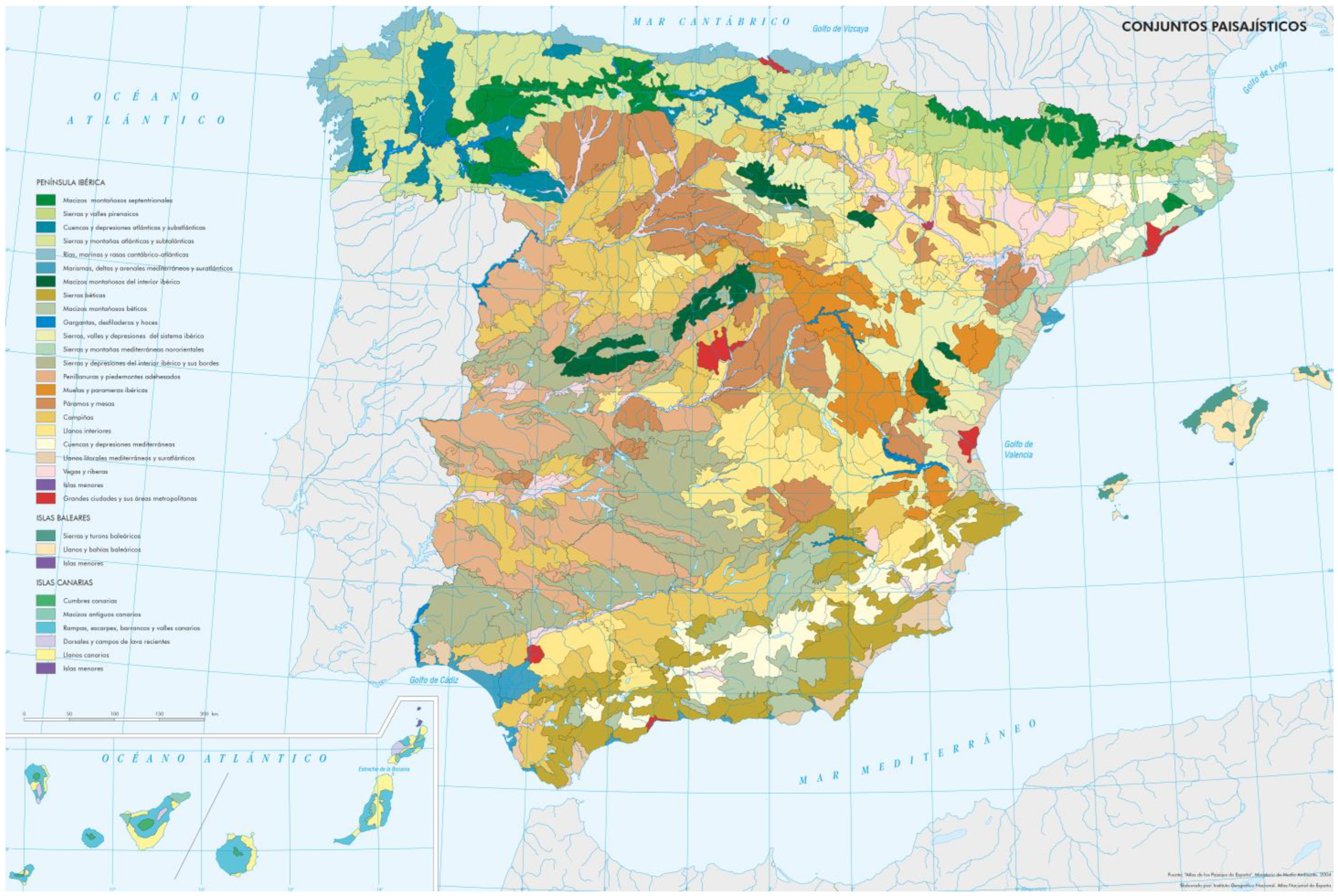
2.1.2. Beginnings of Landscape Cartography: (MAP) Méthode pour des Atlas de Paysages, 1994; (APE) Atlas de los Paisajes de España, 2004 and (CUP) Carta das Unidades de Paisagem, 2004

Neighbouring countries such as France published the Méthode pour des Atlas de Paysages in the 1990s as a strategy for the identification and qualification of French landscapes. In a continuous evolution, the Ministère de l’Écologie du Développement durable et de l’Énergie published its update in 2015 [25].
In the case of Spain, the Atlas de los Paisajes produced, for the first time, a general cartography of all Spanish landscapes, analysing and evaluating them and serving as a basis for further landscape studies at regional and local scales. For this purpose, three levels or scales were established: the basic unit, the intermediate unit, and the larger unit [26]. These are represented by the landscape, landscape types, and associations of landscape types (Figure 2). Despite the importance of the natural component of the landscape in this study, the definition of the intermediate scale included territorial history as a characterising feature.
In parallel, the Portuguese Direção-Geral do Território published the first landscape characterisation of the Portuguese mainland in 2004, developed by the Departamento de Planeamento Biofísico e Paisagístico of the Universidade de Évora. This characterises the landscape in terms of its biophysical components (geology, geomorphology, soils, and climate) in 128 units divided into 22 groups. All landscape units are identified by their own name, geographical location, and approximate area. They are characterised, including their singular elements, panoramic points, and lines or other peculiarities, their urban planning figures, if they contain them (municipal master plans, regional planning plans, etc.), and related bibliography. Finally, they are also photographed and mapped [27].

2.1.3. Conflict as a Defining Feature: (GMEPCV) Guía Metodológica de Estudio del Paisaje de la Comunidad Valenciana, 2006

Following the approval of the Valencian Community Landscape Regulation in 2006, this methodology was born to guide the technicians involved in the development of plans and projects that have an impact on the territory and that require a landscape study, such as the General Plans of the Municipalities [28]. Its clarity, organisation, and ability to summarise make it a reference document for this research. This method also includes conflicts (such as the disappearance and degradation of valuable landscapes, fragmentation, or the appearance of low-quality landscapes), together with development, organisation, or resources, as defining elements of landscape units.

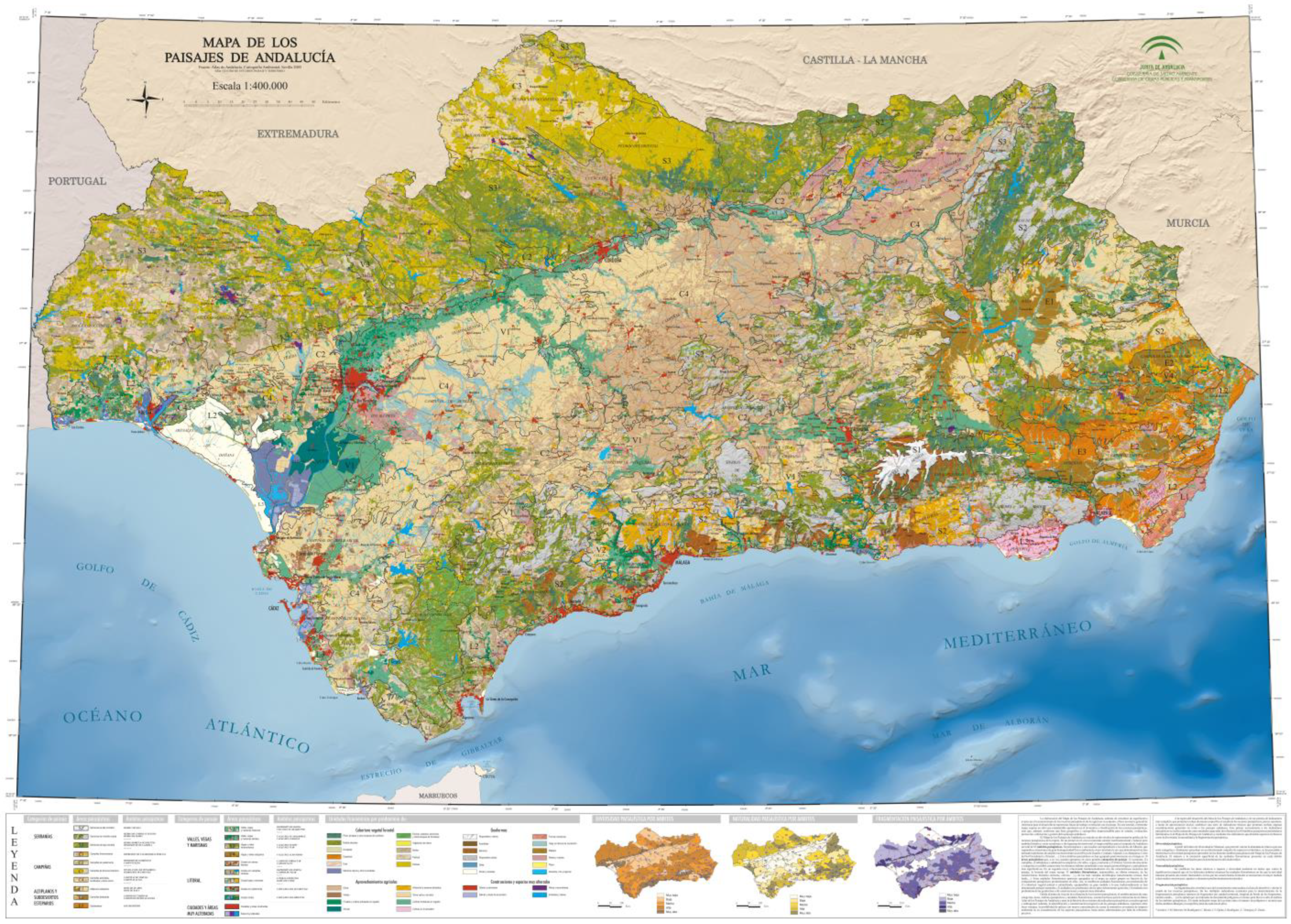
2.1.4. Culture as Landscape Criteria: (MPA) Heritage Characterisation of Mapa de Paisajes de Andalucía, 2008

Following the approval of the European Landscape Convention, the Landscape Map of Andalusia defines a system of landscape indicators at regional and sub-regional scales. These are as follows: landscape richness, landscape diversity index, and landscape naturalness index. To this end, it defines landscape categories, areas, and zones. It is worth highlighting the attention that this method puts on the scenic characteristics of the landscape by defining physiognomic units responsible for certain formal characteristics, such as textures or colours [29,30]. A comprehensive body of classificatory work and satellite images were used to produce maps at a scale of 1:100,000 (Figure 3).
Its importance in this study lies in its role as the basis for the characterisation of the Andalusian Landscape Map. This map is the starting point for the definition of the Landscape Areas, territories with a strong regional personality and with a clear cultural coherence in their landscape image. Based on the areas and spheres proposed by the Landscape Map of Andalusia, a new territorial reading is carried out and 32 demarcations are broken down according to territorial and cultural criteria [31,32]. The description of each of these demarcations according to their contents, grouped in seven information packages, combines the analytical intention with the practical vocation of their use in territorial and urban planning, and includes historical socio-economic processes and activities as part of the characterisation (Figure 4). This is a reference point for this research, establishing the necessary correspondences with the Atlas and the Plan de Ordenación del Territorio de Andalucía.

2.1.5. Reviewing Analytical Resources: (MCMPE) Marco Conceptual y Metodológico para los Paisajes Españoles, 2010

Following the ratification of the European Landscape Convention by Spain in 2008, this publication offers a conceptual and methodological framework that values the usefulness of landscape for proper territorial governance. To this end, it proposes a simplified method for studying landscape in different territorial areas. This method is applied and calibrated through its testing across the three following scales (considered as reference scales for the Convention): local, county, and sub-regional [20]. Although it is applied to rural landscapes, this method is very illustrative in its practical application. Furthermore, its review of sources and attributes, that is, the analytical resources available for each category of LCA data in the Spanish context and the guidelines for characterising landscapes, is an important contribution.

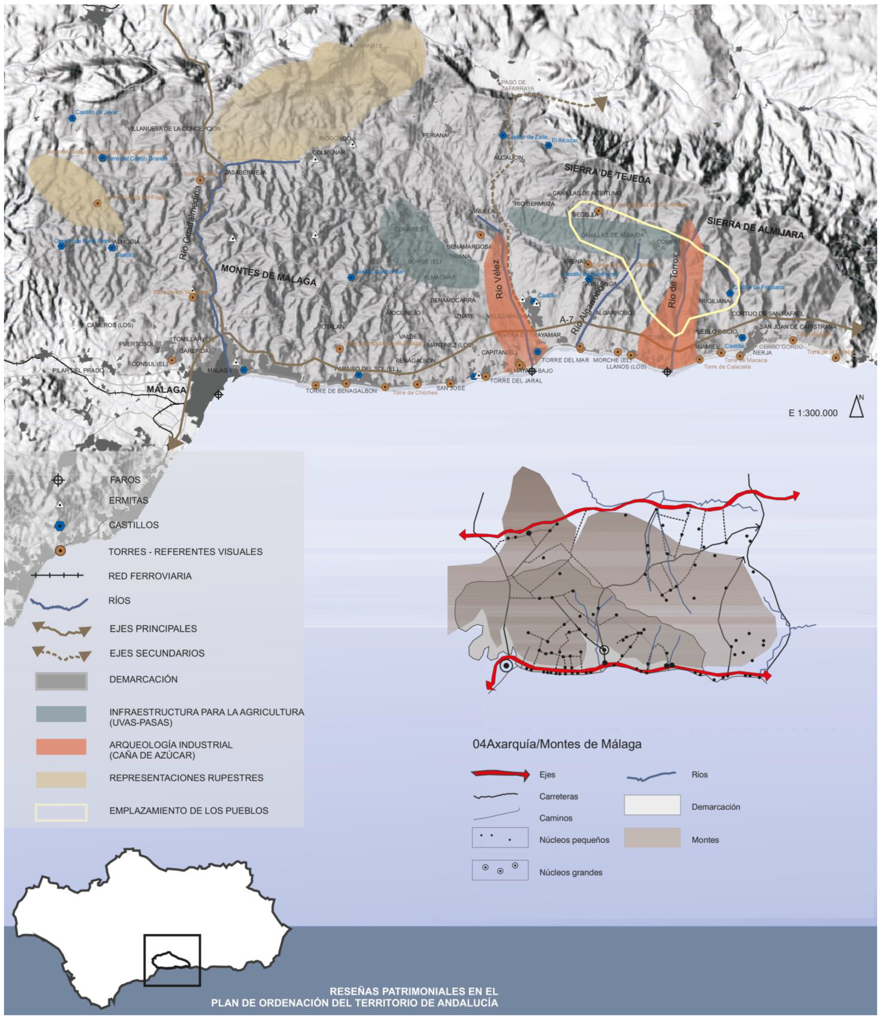
2.1.6. Landscape Inside Cultural Heritage: (RPICA) Registro de Paisajes de Interés Cultural de Andalucía, 2010

This pioneering classification and registration of landscapes in Spain, initiated before the National Cultural Landscape Plan [33] and the Andalusian Landscape Strategy [34], offers a new scale for understanding the values of cultural sites. To this end, the defining criteria for their classification, in addition to the territorial scale and the representativeness of their cultural heritage, include the need for the selected landscapes to have unique perceptual-formal qualities. They must be recognisable, i.e., they must maintain conditions of adequate integrity, conservation, authenticity, contemplation, etc. [35]. For this reason, it does not include landscapes of cultural interest that could be in the Andalusian metropolitan areas, as it specifies that their complexity requires a specific methodological design.
This register is defined as a reconnaissance phase, so it does not define the boundaries of the landscapes, as it is not intended that the areas match the spatial consideration of heritage protection. It defines the scale of representation of the landscapes between 1:40,000 and 1:50,000. It also includes a 3D representation without analytical value, which makes it possible to visualise the main elements of each landscape from a new perspective, different from the zenithal and topographic sections. Another concept implemented by this methodology is the territorial scheme, which classifies the relationship with the environment.

2.1.7. The Provincial/County Perspective and Social Value: (CPPA) Catálogos Provinciales de Paisaje de Andalucía, 2014 and (CPC) Catálogos de Paisaje de Cataluña, 2010

The Provincial Landscape Catalogues are the result of a joint effort by The Regional Ministry of Environment and Territorial Planning and the Centre for Landscape and Territorial Studies, together with the Register of Landscapes of Cultural Interest in Andalusia. Currently, these are only available for the provinces of Seville, Granada, and Malaga.
These works, which include an important compilation of the bibliographical sources used, are divided into five general sections as follows: identification and characterisation of the landscape; historical construction and qualification of the territory; analysis of dynamics, processes and impacts; study of perceptions and public participation; and diagnosis and definition of landscape quality objectives. They also include the natural foundations, historical construction processes and historical representations of landscapes, including urban areas. In addition, a broad and complex social participation approach was developed, consisting of interviews with decision-makers and experts, face-to-face and online surveys, workshops, and discussion groups, which made it possible to identify the social values attributed to the landscapes identified and characterised in the different provinces [36].
In the following years, other Autonomous Communities in Spain have developed catalogues with similar objectives. Particularly noteworthy is the case of Catalonia, whose Landscape Observatory has published, between 2010 and 2019, the catalogues of 6 of its 8 landscape divisions (Terres de Lleida, Camp de Tarragona, Terres de l’Ebre, Comarques Gironines, Regió Metropolitana de Barcelona and Comarques Centrals). In 2016, they also published the methodology used in this cataloguing [37], a document of particular importance in the study of landscapes at the county level.

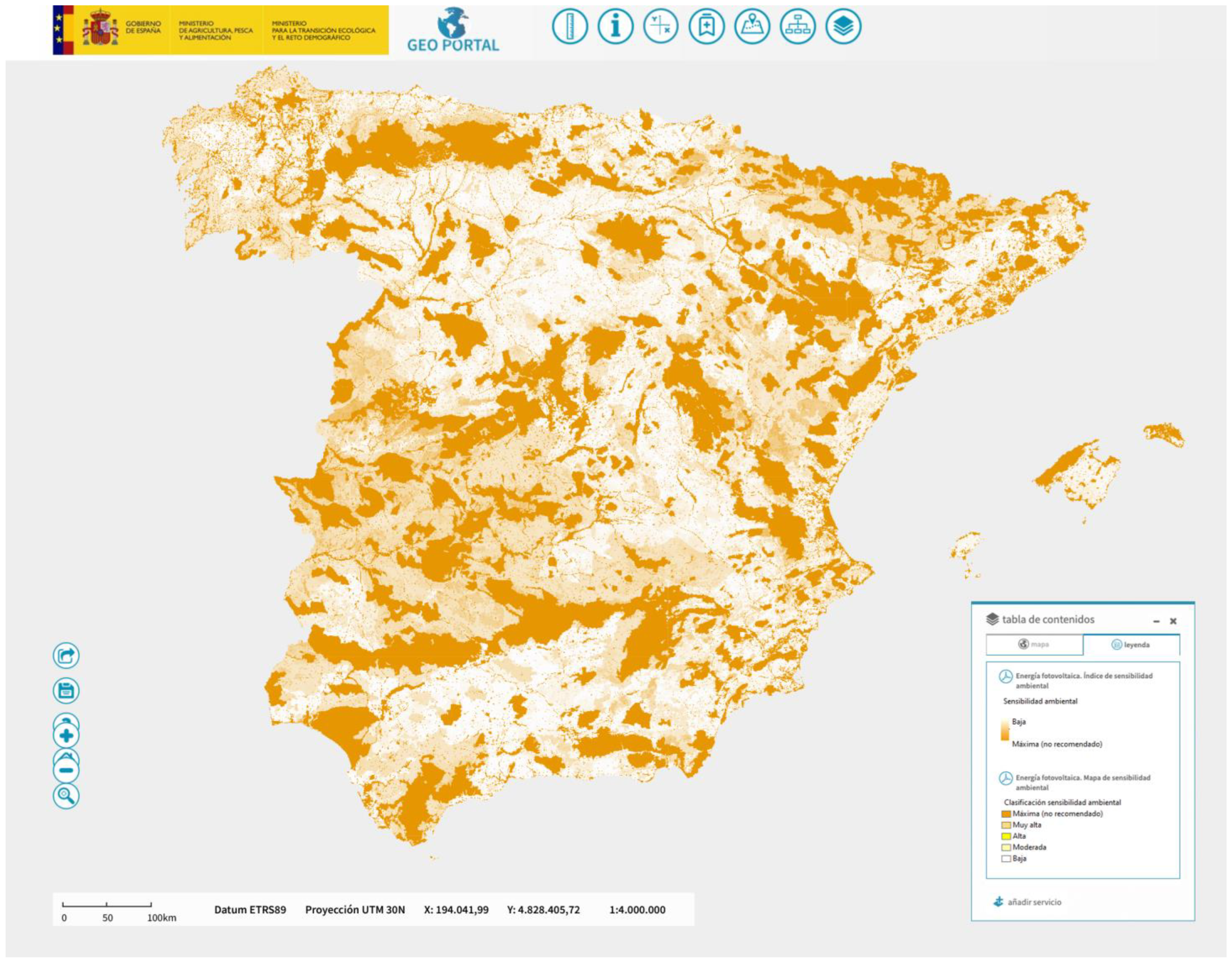
2.1.8. Sensitivity and Resilience: (LSA) Landscape Sensitivity Assessment, 2019

This is one of the UK’s most recent methodological contributions, and it charts a new direction in the characteristics that define today’s landscape. LSA studies are based on the detailed application of the LCA methodology and incorporate the evaluation of the sensitivity of the landscape. That is, its vulnerability to a particular type of development or change. It aims to help planners, architects, landscape architects, developers, and community groups understand the potential impacts of different development scenarios on the landscape. It can be used to inform plans, policies, or strategies for the change of the use of land in development, such as the construction of new renewable energy facilities or housing [38].
In Spain, its use is almost exclusively limited to the energy sector. An example is the environmental zoning for the implementation of renewable energy and the creation of the Environmental Sensitivity Index, developed by the Ministerio para la Transición Ecológica y el reto Demográfico in 2020 (Figure 5).

2.2. Historic Landscape Characterisation Methods

Following the consolidation of landscape characterisation studies, protocols for the characterisation of historic landscapes were developed. The aim of these protocols is to reconstruct the changes that the landscape has undergone by studying its historical evolution. Based on LCA, the first characterisation methodologies emerged in England and spread to Scotland and Ireland, where they have been widely applied at regional and local levels. Since 2000, they have also been linked to the principles established by the European Landscape Convention [20]. These types of methodologies generate, for the countries or regions that have implemented them, a matrix of landscape information that can complement the specific assessment of their heritage assets. Below we explain the highlights of some of these methodologies.

2.2.1. The Pioneering Method, England: (HLC) Historic Landscape Characterisation, 1993

Launched in 1993, this methodology has been applied in 99% of the country by county, regional, and local authorities. All applications are part of the National Historic Landscape Characterisation (NHLC) project, undertaken by Historic England, which aims to provide a comprehensive picture of the historic landscape across the country, including urban and rural areas, and to provide an important context for understanding individual heritage assets. Geographic Information Systems, mapping and aerial photography are used to facilitate the reading of the layers of information collected. The working unit is a polygon of between 1 and 2 hectares, categorised under one of the 17 general types included in the Historic Characterisation Thesaurus. For each polygon, its current function, description, attributes, previous typologies, monuments, and sources of information are defined. Consequently, the material produced by this methodology can be complex for sites that have experienced multiple historical phases [39].
This type of characterisation allows for interrelationships between places, connections, and historical patterns, providing a framework for assessing people’s views and perceptions, such as memories and experiences. It is also particularly useful for local planning tasks, as it can be used at different scales, reaching important levels of detail for design and planning processes.

2.2.2. A New Concept: (LB) Landscape Biography, 1990

In the early 1990s, a new concept of landscape studies was established in the Netherlands. Although not a methodology, Landscape Biography understands cultural history from a social perspective as the life course of a landscape seen through its layers. It thus includes material and immaterial dimensions and integrates knowledge from different disciplines. This concept, developed by Jan Kolen, Dean of the Faculty of Archaeology at the University of Leiden, responds to the societal need to integrate the knowledge of landscape and heritage into the planning and design practice, allowing for greater involvement by citizens in local and regional policies. In the Netherlands, it is increasingly used as a multidisciplinary and participatory approach to developing environmental visions at local and regional level [40]. This approach has been used in various contexts, one of the most important being the large-scale project ‘Protection and Development of the Dutch Archaeological-Historical Landscape and its European Dimension’ [41].

2.2.3. Towards the Characterisation of Urban Landscapes: (UC) Urban Characterisation, 1990

The first approaches to historic landscape characterisation in England are linked to urban landscape characterisation. Following the development of the LCA methodology in the 1990s, three types of strategy have been implemented.
The first, Extensive Urban Survey (EUS), focuses on local archaeological surveys in small towns. The second, Metropolitan Historic Landscape Characterisation, is applied in large urban areas, following the HLA methodology but using general types appropriate to urban areas, reflecting the complexity of urban development. Finally, Urban Archaeological Databases (UADs), implemented in 30 historic cities, capture the rich and complex archaeological heritage. These databases collect and map the archaeological work that has taken place, as well as the features identified in that work [42].

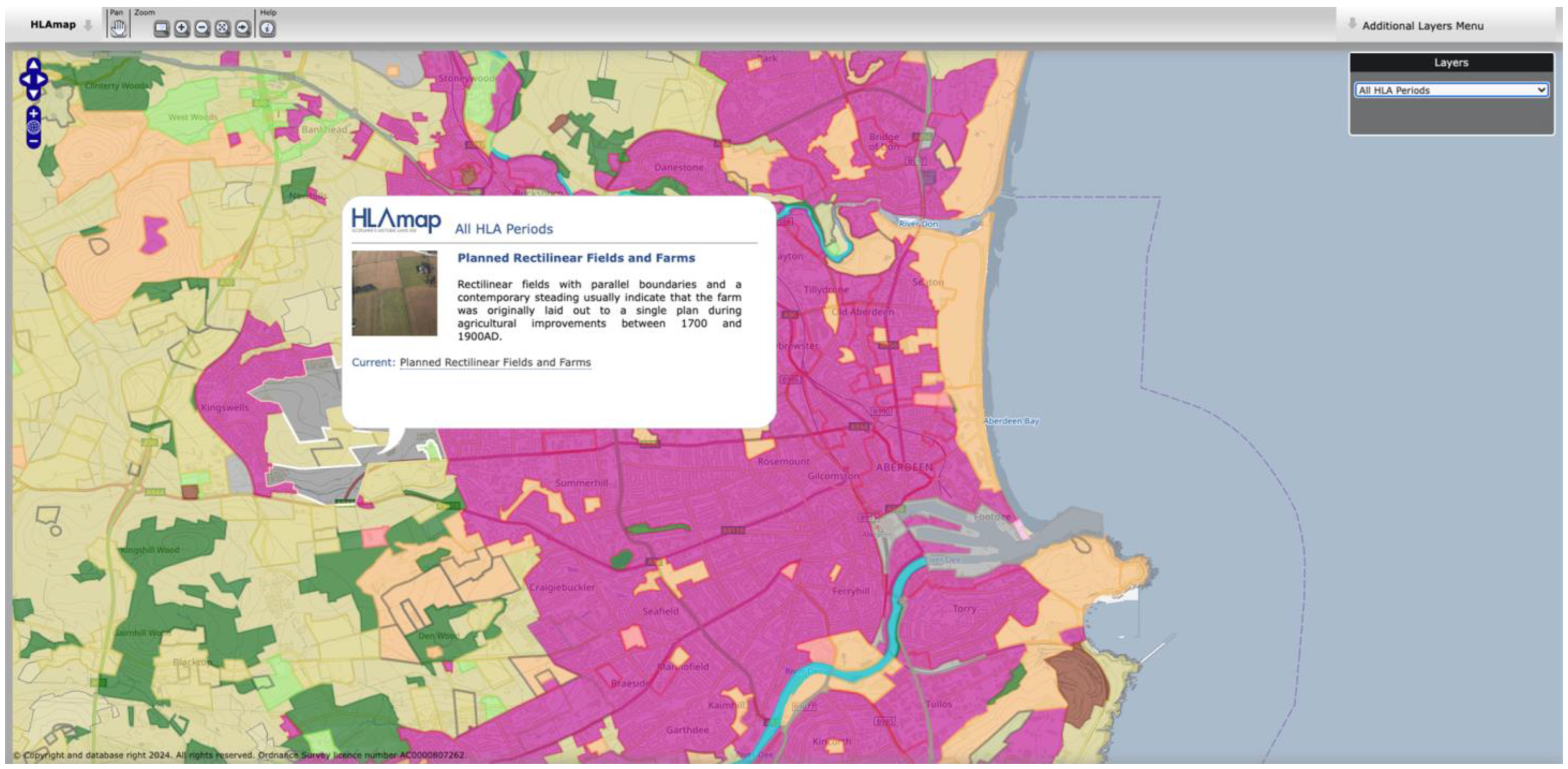
2.2.4. Assessing Land Uses, Scotland: (HLA) Historic Land-Use Assessment, 1994

The HLA, also initiated in 1993, is the successor to the HLC methodology and has since been applied throughout Scotland. It uses a scale of 1:25,000 and includes, for each element, a brief description, current use, and previous use [43]. The main novelty and contribution of this method is that it includes the HLAmap open data viewer, which allows filtering by historical periods or specific land uses and recognises the current and historical uses of urban and rural land across the country (Figure 6). The data collected by Historic Scotland and the Royal Commission on the Ancient and Historical Monuments of Scotland, now Historic Environment Scotland, between 1997 and 2015, defines 80 landscape types grouped into 13 categories.

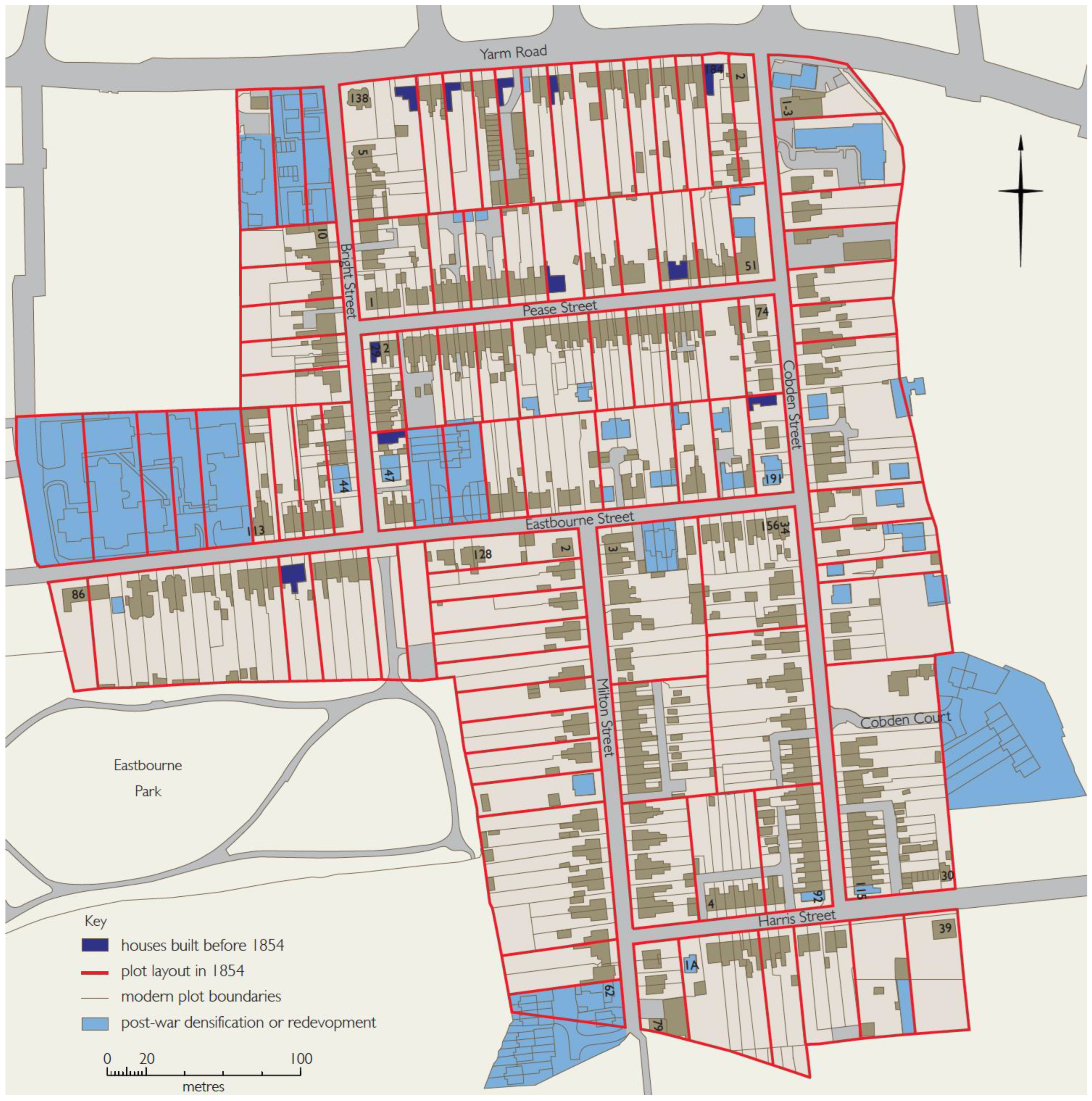
2.2.5. The Particularised Method: (HAAs) Historic Area Assessment, 2010

This practical tool by Historic England is used to understand and set out the historic and heritage interest of a particular area. It has been developed to help define the character of a particular area, highlight its significance, and identify issues that may lead to the alteration of its heritage value. This is its main difference from the HLC, a reduced and controlled scale of application and, therefore, a greater depth of work (Figure 7). In contrast to the historical characterisation methods described above, HAAs place great emphasis on fieldwork, emphasising data obtained through observation. It aims to provide a highly detailed and nuanced analysis of both the landscape and built elements [44].
It has three variants as follows: outline (level 1), fast (level 2), and detailed (level 3). All three can be used independently or in sequence to provide, for example, a general overview of a large area and a detailed analysis of parts of it.
This method is mainly used in historic urban environments, but it can be applied to a wide range of landscape models: small and medium-sized towns, neighbourhoods, villages, historic centres, harbours, industrial areas, dispersed rural areas, and historic linear entities such as canals or railways.

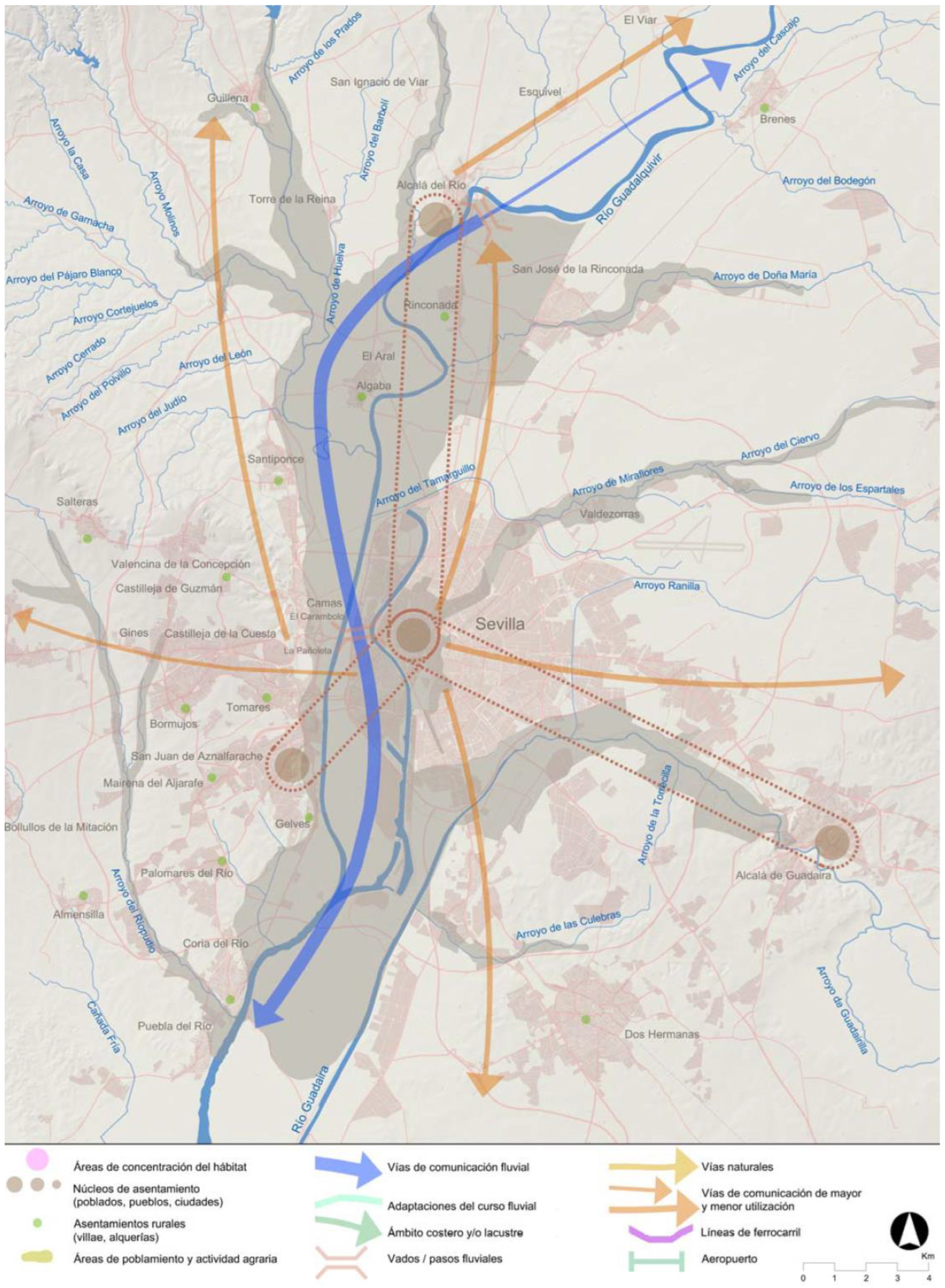
2.2.6. The First Andalusian Case: (GPHUS) the Guía del Paisaje Histórico Urbano de Sevilla, 2010

This guide is the first Andalusian exercise in characterising the historic urban landscape from the dual perspective of natural and cultural heritage. It is divided into two main blocks. The first characterises the historic urban landscape of Seville, and the second establishes a series of objectives for landscape quality and measures for its sustainable management. For its development, the work was divided into a series of thematic studies, grouped into the three following blocks: territorial, heritage, and perception, and impact. The territorial studies include those related to geomorphology, land use, urban planning, and the relationship between the city and the river (Figure 8). The heritage assets are divided into archaeological, industrial, gardens and public spaces, equipment, festive-ceremonial, and commercial. Each of these processes, activities or histories contextualises the assets, reveals the existing relationships between them, and gives them a shared value that goes beyond their individual value. Finally, the last block includes perspectives such as the media and contemporary architecture [45].

2.2.7. Plots, Lines, and Points: (PaHisCat) the Project Paisatge Històric de Catalunya, 2011

In 2011, the Observatori del Paisatge de Catalunya, in collaboration with the History Department of the University of Lleida, launched the PaHisCat pilot project to measure the historical evolution of the Catalan landscape. This project, a pioneer in Spain, is set in a rural context with the aim of understanding and disseminating the traces of the past visible in four landscapes of this community, as well as providing guidelines for territorial, heritage, and sectoral planning. Unlike inventories, it attempts to formulate a reading of those sets of elements that have a landscape explanation from a historical perspective [46]. Its methodology is based on the HLC but defines three types of units: parcels fields, orchards, scrubland, woods and pastures, urban or industrial areas, linear realities roads, irrigation channels or canals and boundaries and specific realities farmhouses, villages, buildings, sites, etc. The summarised results of its application are available in .pdf format, reflecting the different representative historical stages.

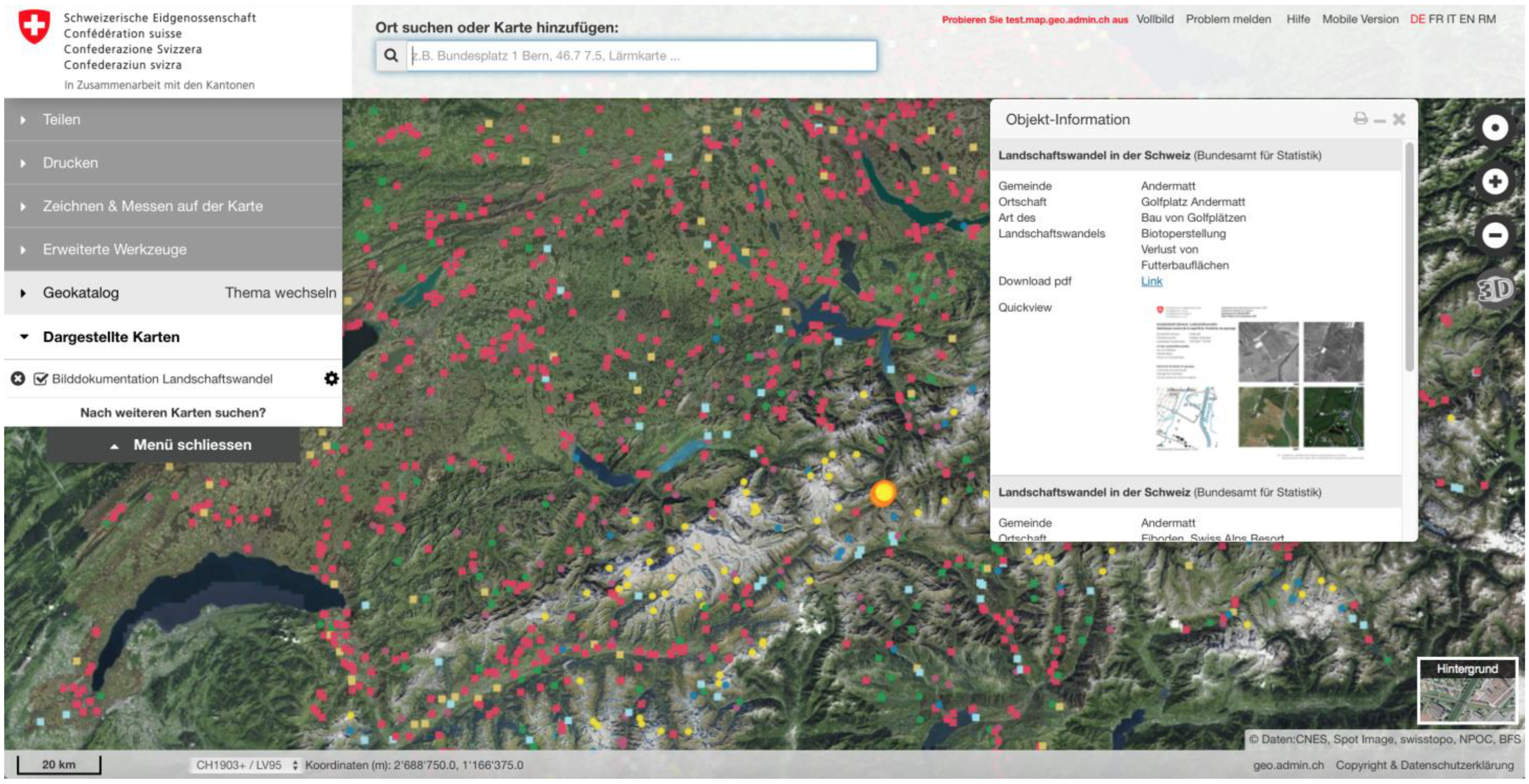
2.2.8. Landscape and Statistical Data: (PDLC) Picture Documentation of Landscape Change, 2020

In Switzerland, the documentation of changes, although relatively recent, uses a new method and is carried out through the regular collection of statistical data on land use. Specifically, through data collected between 1975/85, 1992/97, 2004/09, and 2013/18, and through the registration and georeferencing of aerial photographs during the 2004/09 and 2013/18 periods. The Federal Statistical Office provides more than 1500 image comparisons via an open data geoportal [47]. Land use statistics provide information on the status and changes of built-up areas, forests, arable land, grassland, pastures, water, glaciers, etc. (Figure 9).

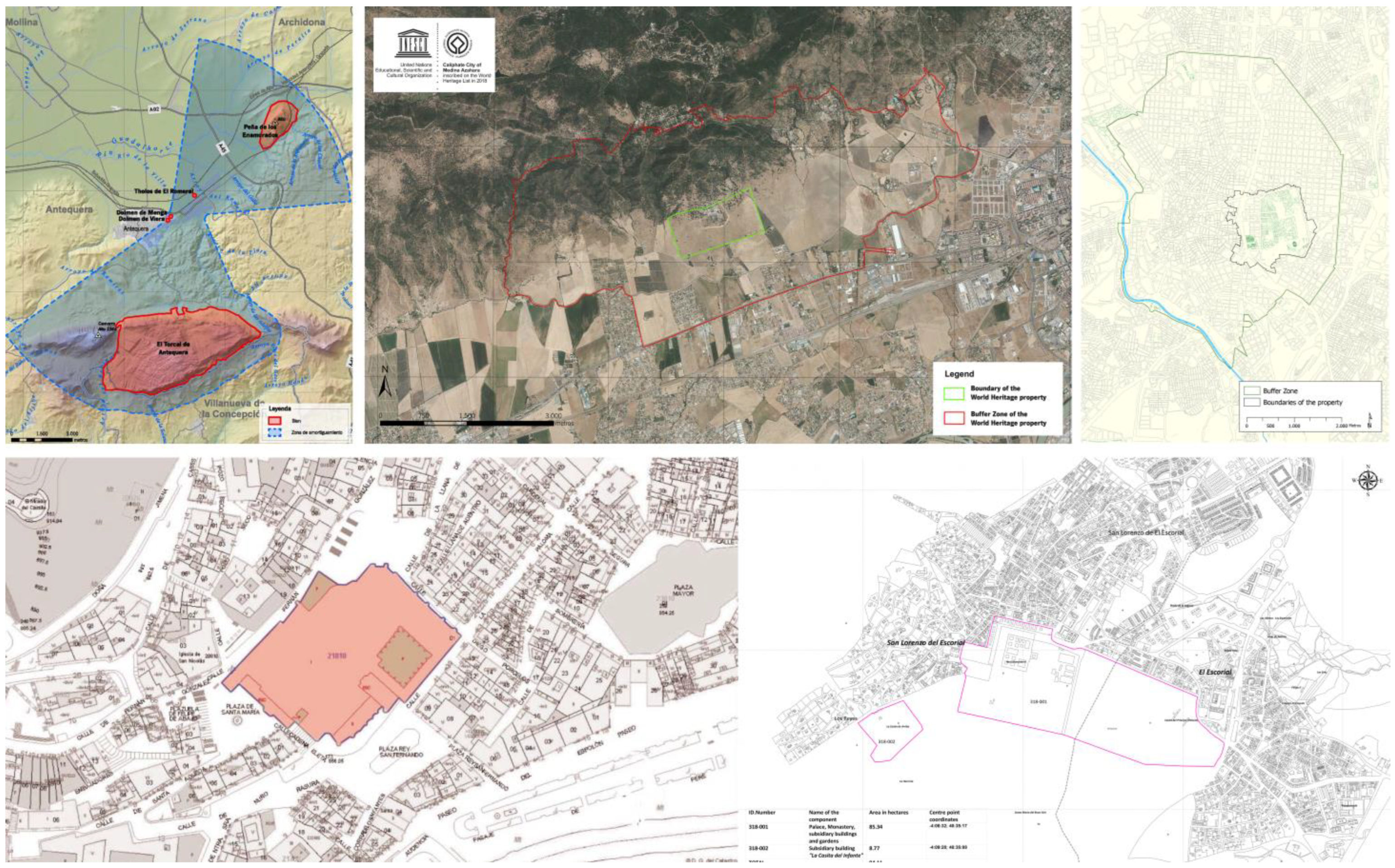
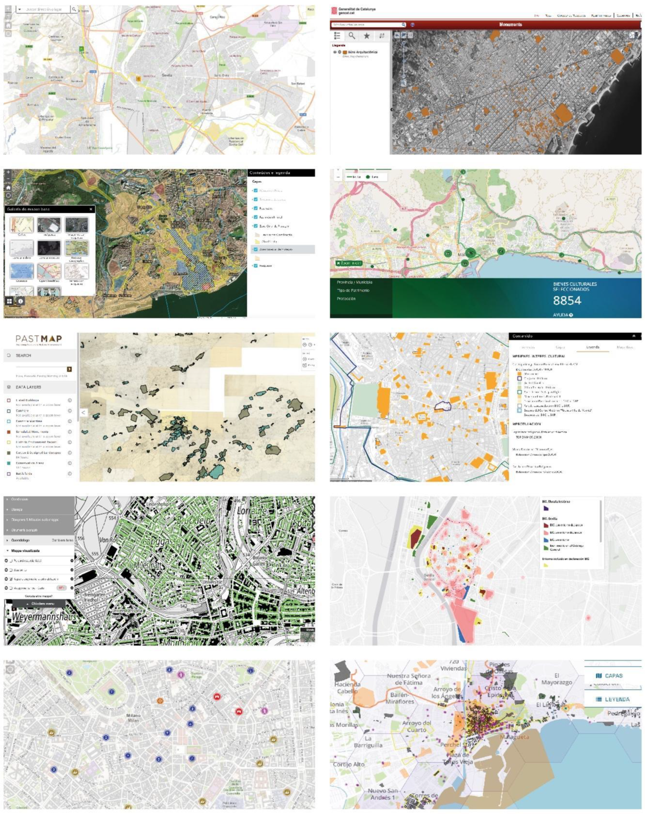
2.3. Geographic Location of Cultural Heritage

Many of the methods included in this selection, especially those for the characterisation of the historical landscape, have viewers for georeferenced information or other tools that make the visualisation of the different layers of information easier and more intuitive. Although Geographical Information and Referencing Systems were initially developed in the field of environmental and military sciences and in support of cartography, their use has also been extended to the historical analysis of territory and to certain branches of human geography, so much so that the generalization of their use to store historical data and record territorial changes through the georeferencing of historical cartography is known as Historical GIS (HGIS) [9,48]. Again, one of the pioneering projects in this respect is in Great Britain, where the University of Portsmouth is working on the so-called Great Britain Historical GIS (GBHGIS), accessible through the website ‘A vision of Britain Through Time’ [49].
In line with these methodologies, maps, guides, and concepts, numerous viewers for the geographical location of heritage assets have been developed in recent years by national, regional, and local governments (Figure 10). They all use GIS technologies for data collection, management, interpretation, and dissemination. As a result, they make it possible to establish relationships between properties and their settings, whether protected or not, and bring a new geographical and territorial component to tangible and intangible heritage.

3. Results and Discussion

The analysis in the previous section demonstrates that European countries have been working intensively for more than three decades to characterise their landscapes from a historical and contemporary perspective. While the UK has been the forerunner of methodological models, a significant body of applications has been generated in different countries and at different scales. To this end, several methodologies have been developed at regional and sub-regional levels.
Although there are many cases that could be included in this research, the selection below represents a broad spectrum that allows us to identify a growing knowledge of territorial value and a common matrix: they are all variations of a type and share the landscape characterisation established by the original LCA method as a basis. From this common starting point, their differences and complementarities are essentially based on the need to adapt to the context (urban, rural, peri-urban, etc.), the inclusion of specificities (cultural, national, regional and/or local) and the scale of the work (large areas or specific cases).
As shown in Table 1 and Table 2, all these methodologies have been developed by public bodies (in most cases of a governmental nature), have involved universities and research centres, and could provide a broader context for other studies, such as heritage assessment ones. This compendium of categorised methodologies and the hyperlinks for their consultation are the first outcome of this research.
As a consequence of all these studies, the dissemination of this knowledge has taken place, as Table 3 shows, through institutional cartographic viewers at a national and international level. All of them are oriented towards a new way of identifying, cataloguing, and consulting cultural heritage wealth.
Based on the previous analysis, the second result of this contribution is shown in Table 4. Here, the main confluences and differences between the analysed methods are summarised.
The analysis of all these methodologies has revealed basic strategies for landscape characterisation which, in line with the reasons given in the Introduction to this paper, should nowadays be part of any work on cultural sites. These strategies are divided in terms of data collection, scales, work units, tools, and dissemination as follows:
  • To carry out fieldwork and to obtain data by observation; to control the sources of natural and anthropic data available; to allow social participation regulated by agents and experts in some of the stages; to establish correspondences with previous landscape studies; to recognise landscape as a dynamic element in which data is constantly changing.
  • To define different scales of application; to propose adaptive levels of depth; to consider limitations in data quality or availability when defining scopes and scales.
  • To work with areas or polygons rather than elements; to use layers of information; to group areas or polygons into families; sometimes it may not be necessary to set specific boundaries.
  • To give great importance to graphic tools; to georeference data; to map; to take photographs; to create three-dimensional views and sections; to include diagrams of territorial dynamics.
  • To make this characterisation accessible through website viewers; to combine the landscape characterisation future viewers with the existing cultural heritage web viewers, when applicable.
Considering the preceding strategies, the final result of this research is the outline of a basic methodological framework to approach the adequate characterisation of cultural assets from an integral perspective. As it has been explained, among the methodologies studied, the following needs have been identified: to establish different scales of work [18,19,44], to recognise the physical environment [36,45], to study its historical context [36,43,44,45,46], to take into account socio-economic resources [18,35,36,45], and to include social perception [28,36].
Thus, according to the rules of LCA, in order to characterise the landscape that contextualises the cultural site, we must establish at least three scales of approach, from the most specific to the most general as follows: the scale of the cultural site itself, Medium/Small (architectural and human scale, how the property is perceived constructively and how it is perceived by the population and institutions); the landscape scale of the cultural site, Large/Medium (administrative scale, considering the landscape regulations and the socio-economic context in which it is inserted, and what historical context preceded its current landscape); and finally, the territorial scale of the cultural site, Large/Extra Large (ecosystem scale, both environmental and geographical, of the territory in which the asset is located). Although the numerical scales will vary according to the size of the asset to be studied, (as it will be different to study engineering works, monuments, or sites of ethnological interest), in general they could be established around M/S 1:25,000, L/M 1:50,000, XL/L 1:150,000.
Within these three major scales, the research will define different dimensions according to the subjects to be studied. Similarly, the specific data that make up each of these themes will constitute the different categories of data that will be needed to compose each of the working dimensions. For example, to characterise the normative dimension (D) of a specific cultural property, one will need access at least to the urban or territorial planning applicable to it (D1), to the figures of land protection or other properties that may coexist in this landscape (D2), and to the precedents that exist in the study of this specific landscape (D3).
Thus, Figure 11 shows the general scheme of working scales, dimensions and data categories that are currently considered fundamental for the characterisation of the territorial, landscape, and architectural context of a given Asset of Cultural Interest. These are as follows:
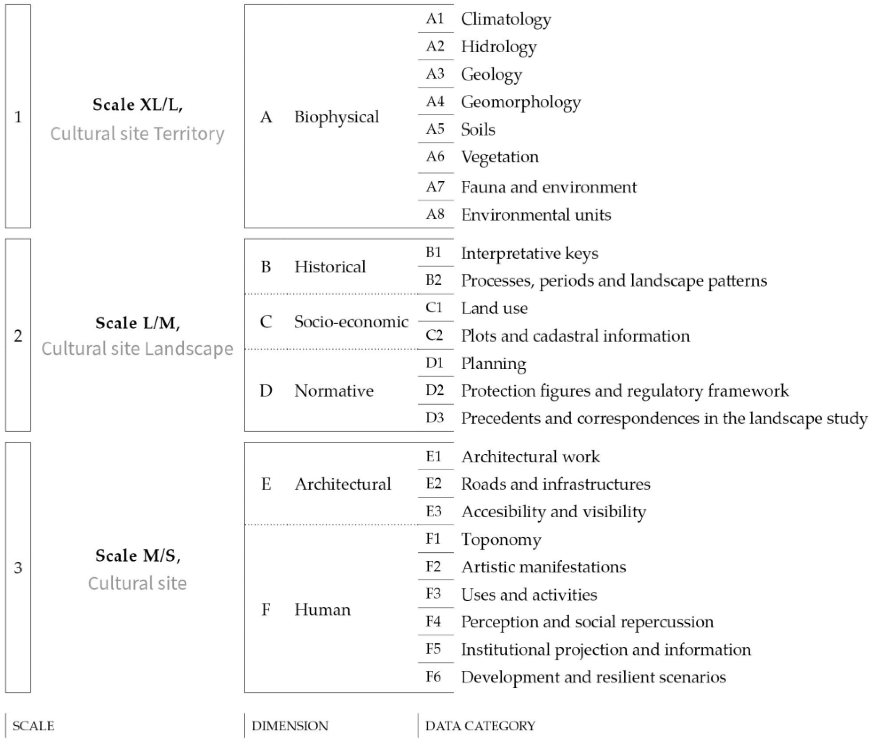
  • Cultural site territory (scale XL/L): this first scale refers to biophysical characteristics and the ecosystem services present at the territory of study. Climate, hydrology, and geology, which are closely linked, will determine the soil types, which in turn will determine the dominant vegetation. A number of environmental units can be defined on the basis of these data categories. These units are related to the following scale, which helps to delineate the landscape area units.
  • Cultural site landscape (scale L/M): the intermediate scale demarcates the landscape of the site as a morphological unit. The characterisation of the cultural site landscape is organised in three working dimensions as follows: historical, socio-economic, and normative. The historical and socio-economic dimensions, in a continuous relationship, characterise the main processes that these landscape areas have undergone and the variations that the landscape has undergone to reach its current use and subdivision. At the same time, the normative dimension examines the existence or non-existence of study, planning, and protection measures in this respect. If the assett studied is in an area already characterised at this landscape scale, we can use the results of that landscape characterisation for this heritage assessment.
  • Cultural site (scale M/S): the closer scale to the assets characterises their architectural, archaeological, and cultural dimension. The architectural analysis includes their level of integrity and state of conservation, their continuity and visibility, and their accessibility. It is also analysed whether the assets have influenced their cultural environment, reflected in toponymy, artistic manifestations, or cultural activities. Finally, the impact on citizens and institutions will be considered and possible development scenarios will be identified.

4. Conclusions for a Methodological Proposal

This study was prompted by a reflection on the increasing scale of heritage assessment and protection over the last decade. The conclusion is the need for more transdisciplinary and subdivided technical studies to cover all the complexities of the current scenario. Thus, this study has contributed to this necessary interdisciplinary body of knowledge through the analysis of tools from geographical disciplines that bring an updated logic to architectural and archaeological heritage studies.
The result of the analysis of the main methodologies for the characterisation of landscapes and historic landscapes has been a compendium of methodologies categorised with hyperlinks for their consultation; the identification of the main similarities and differences between the methodologies analysed; and a first draft of a methodological diagram for the characterisation of cultural sites from a holistic point of view, rather than focusing only on the architectural components. The proposed working diagram approaches the characterisation of cultural sites in an integral way, together with their territorial values, by defining three spatial scales, called Cultural Site, Landscape, and Territory and three levels of data, called scales, dimensions, and categories.
In light of the analysis carried out, some conclusions can be drawn about the evolution and trends of the methods for characterising the current landscape and the historic landscape, which have been considered in the methodological proposal.
The first is the difference in scale used in the methods for characterising the historic landscape compared to those used for current scenarios. Many of the methods derived from HLC use small areas as units, even specific points in the landscape. On the other hand, those derived from LCA use ensembles or more general areas as units for characterising the current landscape.
The second is the scarcity of current landscape characterisation methods exclusively applicable to landscapes of an urban nature. However, there are specific methods for historic landscape characterisation in urban environments. While landscape is understood here in terms of its definition in the European Landscape Convention, these methodologies tend to distinguish between urban and rural, as has been pointed out throughout this research. This scarcity may be due to the greater complexity of change in cities. In urban environments, the physical component of the landscape has greater continuity and characterisation is meaningless if the heritage and historical components are not included. In fact, it is by qualifying the urban landscape according to its cultural interest that different areas of material elements, layouts, and historic uses can be assumed to provide a certain character and represent a particular environment [27]. However, due to continuous human activity in urban areas, these defining aspects are more diffuse and therefore require more complex methods of analysis.
A third conclusion is the lack of dissemination through viewers that characterise the landscape according to LCA models, while those that follow the precepts of the HLC are beginning to implement them. Perhaps because they were developed later, or because they do not address current issues that may conflict with certain public or private interests, being fully visual and accessible.
Finally, in relation to the characterisation of cultural sites, it is important to note that there is a disconnect between the evaluation studies of heritage architecture and the landscape studies that concern them. Nevertheless, such characterisation is the basis for any study of the architectural heritage. To adequately assess a cultural site from a 21st century heritage perspective, it is necessary to start from a much broader scale than the purely architectural. It is only by carrying out this type of study on a large scale that it is possible to obtain a complete characterisation of the heritage, which avoids a biased and outdated view of its values and effects and provides implications for its context. This also helps to define more appropriate protection environments and to identify the intangible values associated with it.
Hence, future research on this topic should seek to identify good practices in architectural heritage assessment that take landscape characterisation methods studied into account, as well as further developing and application of the methodology suggested in this paper.

Funding

The conduct of this research was supported by the [VI Plan Propio de Investigación y Transferencia of the University of Seville] under Grant [VIPPIT-2017-II.2].

Institutional Review Board Statement

Not applicable.

Informed Consent Statement

Not applicable.

Data Availability Statement

The original contributions presented in the study are included in the article, further inquiries can be directed to the corresponding author.

Acknowledgments

The author would like to thank José Peral López and Eduardo Mosquera Adell at the University of Seville for the supervision of this predoctoral research.

Conflicts of Interest

The author declares that she has no known competing financial interests or personal relationships that could have appeared to influence the work reported in this paper.

Notes

1
The country ranks fourth in the world in terms of the number of sites inscribed on the UNESCO World Heritage List, after Italy, China and Germany.
2
As indication of this at the international level, UNESCO established the Interagency Platform on Culture for Sustainable Development (IPCSD) in May 2021. The IPCSD aims to encourage organized discussion and collaboration on the topics of culture and sustainable development.
3
It is necessary to clarify that there are other method classification factors that have proved less appropriate for this research. These are the specific methods for natural, agrarian, urban or rural landscapes, referred to by Gómez Zotano and Riesco Chueca as ‘adjectival methodologies’ [19]. It is understood that, in contrast to the Florence Convention, all territory is landscape and these fragmentary understandings must be overcome.
4
Other methods referring exclusively to agricultural or natural soils have been excluded from this list.

References

  1. Cacho, S.F. La dimensión paisajística en la gestión del patrimonio cultural en España. Estud. Geogr. 2019, 80, e026. [Google Scholar] [CrossRef]
  2. López Sánchez, M.; Tejedor Cabrera, A.; Linares Gómez Del Pulgar, M. Guidelines from the heritage field for the integration of landscape and heritage planning: A systematic literature review. Landsc. Urban Plan 2020, 204, 103931. [Google Scholar] [CrossRef]
  3. González-Varas Ibáñez, I. Buenas prácticas: Concepto, sentido y aplicación para la valoración y gestión de sistemas patrimoniales complejos. Rev. PH 2021, 104, 28. [Google Scholar] [CrossRef]
  4. del Sagrario Morán Blanco, M. ODS y Cultura: La Implementación de la Agenda 2030 en el Ámbito Cultural. Ponencias y Reflexiones Recogidas en el IV Encuentro de Expertos Sobre ODS y Cultura Celebrado en París, 2021, 1st ed.; del Sagrario Morán Blanco, M., Díaz Galán, M.C., Dykinson, S.L., Eds.; Torrosa: Madrid, Spain, 2022. [Google Scholar] [CrossRef]
  5. Silva Pérez, R.; Fernández Salinas, V. El nuevo paradigma del patrimonio y su consideración con los paisajes: Conceptos, métodos y prospectivas. Doc. Anal. Geogr. 2017, 63, 129. [Google Scholar] [CrossRef]
  6. Instituto del Agua de la Universidad de Granada. Conocetusfuentes. 2007. Available online: https://www.conocetusfuentes.com/manantiales_y_fuentes.html (accessed on 11 November 2023).
  7. Riveiro, B.; Arias, P.; Armesto, J.; Ordóñez, C. A Methodology for the Inventory of Historical Infrastructures: Documentation, Current state, and Influencing Factors. Int. J. Archit. Heritage 2011, 5, 629–646. [Google Scholar] [CrossRef]
  8. Universidad de Granada. Memola Project: Mediterranean Mountainous Landscapes, an Historical Approach to Cultural Heritage Based on Traditional Agrosystems; Universidad de Granada: Granada, Spain, 2014; Available online: https://memolaproject.eu/es (accessed on 11 November 2023).
  9. Pascual Aguilar, J.A.; Sanz, J.; de Bustamante, I. Aplicaciones de la Geomática en el Estudio del Patrimonio del Agua. Cuad. Geomática 2015, 3. Available online: https://cpaisaje.org/geomatica_agua/Cuadernos_de_Geomatica_3.pdf (accessed on 11 November 2023).
  10. Marat-Mendes, T.; Mourao, J.; Bento d’Almeida, P.; Niza, S. Water and Agriculture Atlas: Lisbon Region 1900–1940; Instituto Universitário de Lisboa ISCTE-IUL, DINÂ-MIA’CET-IUL: Lisbon, Portugal, 2015. [Google Scholar] [CrossRef]
  11. Besó Ros, A. Las planimetrías del Instituto Geográfico Nacional como fuente para la documentación histórica del patrimonio de la obra pública y del paisaje construido. E-Rph Rev. Electrónica Patrim. Histórico 2018, 22, 184–209. [Google Scholar] [CrossRef]
  12. Turner, S.; Kinnaird, T.; Koparal, E.; Lekakis, S.; Sevara, C. Landscape archaeology, sustainability and the necessity of change. World Archaeol. 2020, 52, 589–606. [Google Scholar] [CrossRef]
  13. Davis, D.S.; DiNapoli, R.J.; Douglass, K. Integrating Point Process Models, Evolutionary Ecology and Traditional Knowledge Improves Landscape Archaeology—A Case from Southwest Madagascar. Geosciences 2020, 10, 287. [Google Scholar] [CrossRef]
  14. Colonese, A.C.; Milheira, R.G. (Eds.) Historical Ecology and Landscape Archaeology in Lowland South America; Springer Nature: Berlin/Heidelberg, Germany, 2023. [Google Scholar]
  15. Déjeant-Pons, M. The environmental, cultural, social and economic dimensions of the landscape. A look at current experiences on the threshold of the 20th anniversary of the adoption of the Convention. Econ. Cult. 2019, 3, 357–370. Available online: https://www.rivisteweb.it/doi/10.1446/95594 (accessed on 11 November 2023).
  16. De la O Cabrera, M.R.; Marine, N.; Escudero, D. Spatialities of cultural landscapes: Towards a unified vision of Spanish practices within the European Landscape Convention. Eur. Plan. Stud. 2020, 28, 1877–1898. [Google Scholar] [CrossRef]
  17. Marine, N. Landscape Assessment Methods Derived from the European Landscape Convention: Comparison of Three Spanish Cases. Earth 2022, 3, 522–536. [Google Scholar] [CrossRef]
  18. Fairclough, G.; Sarlöv Herlin, I.; Swanwick, C. (Eds.) Routledge Handbook of Landscape Character Assessment. Current Approaches to Characterisation and Assessment; Routledge: London, UK, 2018. [Google Scholar]
  19. Gómez Zotano, J.; Riesco Chueca, P. Marco Conceptual y Metodológico para los Paisajes Españoles: Aplicación a Tres Escalas Espaciales; Consejería de Obras Públicas y Vivienda, Centro de Estudios Paisaje y Territorio: Sevilla, Spain, 2010. [Google Scholar]
  20. Council of Europe. The European Landscape Convention; Council of Europe: Strasbourg, France, 2000; Available online: https://rm.coe.int/european-landscape-convention-book-text-feb-2008-en/16802f80c6 (accessed on 11 November 2023).
  21. Instrumento de ratificación del Convenio Europeo del Paisaje (número 176 del Consejo de Europa), hecho en Florencia el 20 de octubre de 2000. Boletín Of. Estado 2008, 31, 6259–6263. Available online: https://www.boe.es/buscar/doc.php?id=BOE-A-2008-1899 (accessed on 11 November 2023).
  22. Terkenli, S.T.; Gkoltsiou, A.; Kavroudakis, D. The interplay of objectivity and subjectivity in Landscape Character Assessment: Qualitative and Quantitative approaches and challenges. Land 2021, 10, 53. [Google Scholar] [CrossRef]
  23. Simensen, T.; Halvorsen, R.; Erikstad, L. Methods for landscape characterisation and mapping: A systematic review. Land Use Policy 2018, 75, 557–569. [Google Scholar] [CrossRef]
  24. Natural England; Department for Environment, Food & Rural Affairs. Landscape Character Assessment Guidance; Department for Environment, Food & Rural Affairs: London, UK, 2014. [Google Scholar]
  25. Ministère de l’Écologie, du D. durable et de l’Énergie. Les Atlas de Paysages. Méthode pour l’Identification, la Caractérisation et la Qualification des Paysages, France. 2015. Available online: https://www.ecologique-solidaire.gouv.fr/sites/default/files/Les Atlas de paysages%2C Méthode pour l%27identification%2C la caractérisation et la qualification des paysages.pdf (accessed on 2 November 2023).
  26. Ministerio para la Transición Ecológica y el Reto Demográfico. Atlas de los Paisajes de España; Centro de Publicaciones, Ministerio de Medio Ambiente: Madrid, Spain, 2004. [Google Scholar]
  27. Pinto-Correia, T.; Cancela D’Abreu, A.; Oliveira, R. Identificação de unidades de paisagem: Metodologia aplicada a Portugal continental. Finisterra 2001, 36, 195–206. [Google Scholar] [CrossRef]
  28. Muñoz Criado, A. Guía Metodológica: Estudio de Paisaje de la Generalitat Valenciana; Conselleria de Infraestructuras Territorio y Medio Ambiente: Valencia, Spain, 2012; Available online: https://www.upv.es/contenidos/CAMUNISO/info/U0670136.pdf (accessed on 2 November 2023).
  29. Consejería de Obras Públicas y Transportes Consejería de Medio Ambiente. Atlas de Andalucía. Tomo II. Cartografía Ecológica y Territorial Escala 1:400.000; Junta de Andalucía. Consejería de Fomento y Vivienda: Sevilla, Spain, 2005. [Google Scholar]
  30. Junta de Andalucía; Consejería de Medio Ambiente y Ordenación del Territorio. Mapa de Paisajes de Andalucía, 2003. Available online: https://portalrediam.cica.es/descargas?path=%2F04_RECURSOS_NATURALES%2F05_PAISAJES%2F00_PAISAJES%2FMapa_paisaje_atlas (accessed on 2 November 2023).
  31. Fernández Cacho, S.; Fernández Salinas, V.; Hernández León, E.; López Martín, E.; Quintero Morón, V.; Rodrigo Cámara, J.M.; Zarza Ballugera, D. Caracterización patrimonial del mapa de paisajes de Andalucía. Rev. PH 2008, 66, 16–31. [Google Scholar] [CrossRef]
  32. Fernández-Baca Casares, R.; Fernández Cacho, S. (Eds.) Paisajes y Patrimonio cultural en Andalucía: Tiempo, Usos e Imágenes; Consejería de Cultura, Instituto Andaluz del Patrimonio Histórico: Sevilla, Spain, 2010. [Google Scholar]
  33. Ministerio de Cultura y Deporte. Plan Nacional de Paisaje Cultural. 2012. Available online: https://www.culturaydeporte.gob.es/planes-nacionales/planes-nacionales/paisaje-cultural.html (accessed on 14 November 2023).
  34. Junta de Andalucía. Estrategia de Paisaje de Andalucía. 2012. Available online: https://www.juntadeandalucia.es/medioambiente/portal/documents/20151/2761419/Estrategia_de_Paisaje_de_Andalucia_2012.pdf/9e432b61-e3a0-646d-a036-146ab643ee45 (accessed on 14 November 2023).
  35. Rodrigo Cámara, J.M.; Díaz Iglesias, J.M.; Fernández Cacho, S.; Fernández Salinas, V.; Hernández León, E.; Quintero Morón, V. Registro de paisajes de interés cultural de Andalucía, criterios y metodología. Rev. PH 2012, 81, 64–75. [Google Scholar] [CrossRef]
  36. Consejería de Fomento Infraestructuras y Ordenación del Territorio. Catálogos Provinciales de Paisaje de Andalucía. 2014. Available online: https://www.juntadeandalucia.es/organismos/fomentoinfraestructurasyordenaciondelterritorio/areas/ordenacion/paisaje/paginas/catalogos-provinciales-paisajes-andalucia.html (accessed on 14 November 2023).
  37. Nogué, J.; Sala, P.; Grau, J. Els Catàlegs de Paisatge de Catalunya: Metodología; Observatori del Paisatge de Catalunya, ATLL, Concessionària de la Generalitat, SA: Barcelona, Spain, 2016. [Google Scholar]
  38. Tudor, C. An Approach to Landscape Sensitivity Assessment—To Inform Spatial Planning and Land Management (Issue June). 2019. Available online: https://assets.publishing.service.gov.uk/media/5d2f005aed915d2fe684675b/landscape-sensitivity-assessment-2019.pdf (accessed on 15 October 2023).
  39. Aldred, O.; Fairclough, G. Historic Landscape Characterisation. Taking Stock of the Method; English Heritage: London, UK, 2003; Available online: https://historicengland.org.uk/images-books/publications/hlc-taking-stock-of-the-method/ (accessed on 15 October 2023).
  40. Kolen, J.; Renes, H.; Hermans, R. (Eds.) Landscape Biographies; Amsterdam University Press: Amsterdam, The Netherlands, 2015. [Google Scholar]
  41. Van der Valk, A.J.J.; Bloemers, J.H.F.; Kars, H.; Wijnen, M. (Eds.) The Cultural Landscape & Heritage Paradox; Protection and Development of the Dutch Archeological-Historical Landscape and Its European Dimension; Amsterdam University Press: Amsterdam, The Netherlands, 2010. [Google Scholar]
  42. Historic England. Urban Characterisation. Available online: https://historicengland.org.uk/research/methods/characterisation/urban-characterisation/ (accessed on 15 October 2023).
  43. Historic Environment Scotland. Historic Land-Use Assessment. Available online: https://hlamap.org.uk/content/to-begin (accessed on 15 October 2023).
  44. Historic England. Understanding Place: Historic Area Assessments. 2017. Available online: https://historicengland.org.uk/images-books/publications/understanding-place-historic-area-assessments/ (accessed on 15 October 2023).
  45. Fernández-Baca Casares, R.; Fernández Cacho, S.; Salmerón Escobar, P. Guía del Paisaje Histórico Urbano de Sevilla: Documento Divulgativo; Junta de Andalucía, Consejería de Cultura: Sevilla, Spain, 2017. [Google Scholar]
  46. Observatori del Paisatge de Catanlunya; Universitat de Lleida. PaHisCat Paisatge Històric de Catalunya. 2011. Available online: http://www.paisatgehistoric.udl.cat/PaHisCat/ca/projectePaHisCat/deCatalunyaAEuropa.php (accessed on 15 October 2023).
  47. Federal Statistical Office. Picture Documentation of Landscape Change in Switzerland. 2020. Available online: https://www.geo.admin.ch/en/home.detail.news.html/geo-internet/2020/datasetoftheweek20200918.html (accessed on 16 October 2023).
  48. Gatta, G.; Bitelli, G. A HGIS for the Study of Waterways: The case of Bologna as Ancient City of Waters. IOP Conf. Ser. Mater. Sci. Eng. 2020, 949, 012051. [Google Scholar] [CrossRef]
  49. University of Portsmouth. A Vision of Britain Through Time. 2017. Available online: https://www.visionofbritain.org.uk (accessed on 15 October 2023).
Figure 1. The Antequera Dolmens Site (upper left), the Caliphate City of Medina Azahara (upper centre) and the Paseo del Prado and Buen Retiro Landscape of Arts and Science (upper right) are some of the latest Spanish additions to the World Heritage List (2016, 2018, and 2021, respectively). The three of them represent this new generation of cultural sites in which the territory plays a crucial role. On the other hand, the Burgos Cathedral (lower left) and the Monastery and Site of the Escurial (lower right) are some of the very first Spanish sites to be added to the List (both in 1984). Source: Unesco World Heritage Convention. Retrieved from: https://whc.unesco.org/en/list/ (accessed on 24 November 2023).
Architecture 04 00013 g001
Figure 2. Atlas Nacional de España, landscape ensembles. Source: Instituto Geográfico Nacional, 2004. Retrieved from: https://atlasnacional.ign.es/wane/Tipolog%C3%ADa_de_paisajes (accessed on 24 November 2023).
Architecture 04 00013 g002
Figure 3. Mapa de Paisajes de Andalucía. Source: Consejería de Sostenibilidad, Medio Ambiente y Economía Azul, 2003. Retrieved from: https://www.juntadeandalucia.es/medioambiente/portal/landing-page-%C3%ADndice/-/asset_publisher/zX2ouZa4r1Rf/content/mapa-de-paisajes-de-andaluc-c3-ada/20151 (accessed on 24 November 2023).
Architecture 04 00013 g003
Figure 4. Identification, location, and territorial articulation of the Axarquia-Montes de Malaga Landscape Demarcation (Malaga). Source: Instituto Andaluz del Patrimonio Histórico, Consejería de Educación, Cultura y Deporte, 2008. Retrieved from: https://repositorio.iaph.es/handle/11532/21?offset=0 (accessed on 27 November 2023).
Architecture 04 00013 g004
Figure 5. Environmental Zoning Map for the implementation of renewable energies. Source: Ministerio para la Transición Energética y el Reto Demográfico, 2020. Retrieved from: https://sig.mapama.gob.es/geoportal/ (accessed on 27 November 2023).
Architecture 04 00013 g005
Figure 6. HLA Map Scotland’s historic land use. Source: Historic Environment Scotland, 2021. Retrieved from: https://map.hlamap.org.uk/#zoom=7&lat=806763.29464&lon=392306.41619&layers=BTFFFTFTTT (accessed on 27 November 2023).
Architecture 04 00013 g006
Figure 7. Survey of Land Tenure in Eastbourne, Darlington, County Durham in 1854. Source: Historic England, 2017. Retrieved from: https://historicengland.org.uk/images-books/publications/understanding-place-historic-area-assessments/heag146-understanding-place-haa/ (accessed on 27 November 2023).
Architecture 04 00013 g007
Figure 8. Diagram of the territorial articulation of Seville, centralized and fortified pattern of the city-kingdom from 700 to 1492. Source: [45].
Architecture 04 00013 g008
Figure 9. Picture Documentation of Lasdscape Change Methodology Viewer. Source: Swiss Confederation, 2021. Retrieved from: https://map.geo.admin.ch (accessed on 27 November 2023).
Architecture 04 00013 g009
Figure 10. From top to bottom and left to right: Visualizador Naturaleza, Cultura y Ocio; Mapa dels béns arquitectònics de Catalunya; Atlas do património classificado e em vias de classificação; Guía digital del Patrimonio Cultural de Andalucía; PASTMAP Exploring Scotland Historic Environment; Catálogo Geográfico de Bienes Inmuebles del Patrimonio Histórico en el municipio de Madrid; Geoportale Federale; Visor del Catálogo General de Patrimonio Histórico Andaluz en Sevilla; Bella Lombardia, Guide to the cultural heritages of Lombardy; Malakanet, Plataforma de información y gestión del Patrimonio Histórico del municipio de Málaga. Sources: Instituto Geográfico Nacional español; Generalitat de Catalunya; Direçao General do Patrimonio Cultural de Portugal; Instituto Andaluz del Patrimonio Histórico; Historic Environment Scotland; Ayuntamiento de Madrid; Ufficio federale della cultura suiza; Ayuntamiento de Sevilla; Regione Lombardia; Ayuntamiento and Universidad de Málaga.
Architecture 04 00013 g010
Figure 11. Diagram of the proposed methodology. Source: Author, 2022.
Architecture 04 00013 g011
Table 1. Categorisation and hyperlinking of methodologies, maps, and guides to landscape characterisation according to scope, organisation, and publication period. Source: Author, 2022.
Main Landscape Characterisation Methods
NameTermNaturePublic BodyOrigin
LCALandscape Character
Assessment
19802014MethodologyNatural EnglandUK
(England)
LSALandscape Sensitivity
Assessment
2019MethodologyNatural EnglandUK
Methodologies derived applicable to both urban and rural contexts
MAPMéthode pour des Atlas de Paysages19942015MethodologyMinistère de
l’Écologie du
Développement
France
MPACaracterización patrimonial del Mapa de Paisajes de
Andalucía
20032011MapConsejería de Medio Ambiente &
Universidad de Sevilla
Spain
(Andalusia)
APEMetodología para el Atlas de los Paisajes de España2004MapMinisterio de
Medio Ambiente
Spain
CUPMetodología para la Carta das Unidades de Paisagem de Portugal Continental2004MapDireção-Geral do TerritórioPortugal
GMEPCVGuía metodológica de estudio del paisaje de la
Comunidad Valenciana
2006MethodologyGeneralitat
Valenciana
Spain
(Comunidad Valenciana)
CPCCatálogos de Paisaje de
Cataluña
20102019CatalogueObservatori
del Paisatge
Spain
(Catalonia)
CPPAMetodología Catálogos
Provinciales de Paisaje de Andalucía
20142015CatalogueCentro de Estudios Paisaje y TerritorioSpain
(Andalusia)
Methodologies derived applicable exclusively to rural contexts
MCMPEMarco conceptual y
metodológico para los paisajes españoles.
2010MethodologyCentro de Estudios Paisaje y TerritorioSpain
(Andalusia)
RPICAMetodología para el
Registro de paisajes de
interés cultural
de Andalucía
20102019RegisterInstituto Andaluz del Patrimonio HistóricoSpain
(Andalusia)
Table 2. Categorisation and hyperlinking of methodologies, maps, and guides for characterising the historic landscape according to area, organisation, and publication period. Source: Author, 2022.
Main Historic Landscape Characterisation Methods
NameTermNaturePublic BodyOrigin
LBLandscape Biography19902015BookCentre for
Global Heritage and
Development
The
Netherlands
HLCHistoric Landscape Characterisation19932003MethodologyHistoric EnglandUK
(England)
Methodologies derived applicable to both urban and rural contexts
HLAHistoric Land-Use Assessment19942020MethodologyHistoric
Environment
Scotland
UK
(Scotland)
HAASHistoric Area Assessment20102017MethodologyHistoric EnglandUK
(England)
PDLCPicture documentation of landscape change2020MapFederal
Statistical Office
Switzerland
Methodologies derived applicable exclusively to rural contexts
PaHisCatPaisatge Històric de Catalunya20112015Methodological
Project
Observatori del
Paisatge de
Catalunya &
Universitat de Lleida
Spain
(Catalonia)
Methodologies derived applicable exclusively to urban contexts
UCUrban Characterisation1990MethodologyHistoric EnglandUK
(England)
GPHUSGuía del Paisaje Histórico Urbano de Sevilla20102017GuideInstituto
Andaluz del
Patrimonio
Histórico
Spain
(Andalusia)
Table 3. Categorisation of cultural heritage web viewers. Source: Author, 2022.
European Context Examples (National and Regional)
Scale (N/R)Public BodyViewer
Portugal (N)Direção General do Património CulturalAtlas do património classificado e em vias de classificação
Scotland (N)Historic Environment ScotlandPASTMAP Exploring Scotland Historic Environment
England (N)Historic EnglandMap Search
Switzerland (N)Ufficio Federale della CulturaGeoportale federale
Lombardy (R)Regione LombardiaBella Lombardia, Guide to the cultural heritages of Lombardy
Spanish Context (National, Regional, Municipal)
Scale (N/R/M)Public BodyViewer
Spain (N)Instituto Geográfico NacionalVisualizador Naturaleza,
Cultura y Ocio
Catalonia (R)Generalitat de CatalunyaMapa dels béns arquitectònics de Catalunya
Andalusia (R)Instituto Andaluz del Patrimonio HistóricoGuía Digital del Patrimonio Cultural de Andalucía
Instituto de Estadística y Cartografía de AndalucíaDatos Espaciales de Referencia de Andalucía (DERA)
Madrid (M)Ayuntamiento de MadridCatálogo Geográfico de Bienes Inmuebles del Patrimonio Histórico en el municipio de Madrid
Seville (M)Ayuntamiento de SevillaVisor del Catálogo General de Patrimonio Histórico Andaluz en Sevilla
Malaga (M)Ayuntamiento & Universidad de MálagaMalakanet, Plataforma de información y gestión del Patrimonio Histórico del municipio de Málaga
Table 4. Categorisation of cultural heritage web viewers. Source: Author, 2024.
Landscape Characterisation Methods
ScaleUnitsToolsDissemination
LCAAny scaleEnsembles, ZonesAll the necessary tools can be employedDigital booklet
MAPNational, Departamental, RegionalEnsembles, ZonesGeoreferenced maps, photographs, Spatial graphic codes, Three dimentional viewsDigital book
MPARegionalEnsembles, ZonesGeorreferenced mapDigital booklet, shapefile
APENationalEnsemblesGeoreferenced mapBook, shape file
CUPNational EnsemblesGeoreferenced mapDigital book
GMEPCVRegional, SubregionalZonesPhotographs, Georreferenced maps, diagramsDigital booklet
CPCRegional, SubregionalZonesPhotographs, charts, Georreferenced mapsWebsite, Video, Digital booklet
CPPASubregional, County ZonesPhotographs, charts, Georreferenced maps, historic views, panoramic viewsDigital book
LSAAny scaleZonesGeorreferenced maps, chartsDigital booklet
MCMPELocal, County, Sub-regionalZonesPhotographs, Georreferenced maps, orthophotographs, charts Digital book
RPICARegionalPoints,
Ensembles
Georreferenced maps, Spatial graphic codes, photographs, orthophotographs, sectionsDigital booklet
Historic Landscape Characterisation Methods
ScaleUnitsToolsDissemination
LBAny scaleAny unitPhotographs, textsBook
HLCAny scaleSmall areasGeorreferenced maps, orthophotographsDigital Booklet
HLANationalSmall areasGeorreferenced maps, photographsWebsite, online viewer
HAASLocalSmall areasGeorreferenced maps, photographsDigital Booklet
PDLCNationalPointsGeorreferenced maps, photographs, historic viewsOnline viewer
PaHisCatRegional, SubregionalZonesGeorreferenced mapsWebsite, Digital Booklet
UCMetropolitan, LocalSmall areasGeorreferenced mapsWebsite
GPHSLocalNone, thematic studiesPhotographs, Georreferenced maps, tables, textBook
Disclaimer/Publisher’s Note: The statements, opinions and data contained in all publications are solely those of the individual author(s) and contributor(s) and not of MDPI and/or the editor(s). MDPI and/or the editor(s) disclaim responsibility for any injury to people or property resulting from any ideas, methods, instructions or products referred to in the content.

