Article

Did the COVID-19 Pandemic Disproportionately Affect the Most Socioeconomically Vulnerable Areas of Brazil?

by
Jonatha C. dos Santos Alves
1,2,
Caíque J. N. Ribeiro
1,2,3,
Shirley V. M. A. Lima
1,2,3,
Gabriel S. Morato
4,
Lucas A. Andrade
2,5,
Márcio B. Santos
2,5,6,
Álvaro F. Lopes de Sousa
7,
Katya A. Nogales Crespo
8,
Damião da C. Araújo
1,2,3 and
Allan D. dos Santos
1,2,3,*
1
Graduate Nursing Program, Federal University of Sergipe, Aracaju 49100-000, Brazil
2
Collective Health Research Center, Federal University of Sergipe, Aracaju 49400-000, Brazil
3
Department of Nursing, Federal University of Sergipe, Lagarto 49400-000, Brazil
4
Department of Medicine, Federal University of Sergipe, Lagarto 49400-000, Brazil
5
Graduate Program in Health Sciences, Federal University of Sergipe, Aracaju 49100-000, Brazil
6
Graduate Program in Parasitic Biology, Federal University of Sergipe, Aracaju 49400-000, Brazil
7
Teaching and Research Institute, Sírio-Libanês Hospital, São Paulo 01308-060, Brazil
8
National School of Public Health, NOVA University Lisbon, 1600-560 Lisbon, Portugal
*
Author to whom correspondence should be addressed.
COVID 2023, 3(6), 924-936; https://doi.org/10.3390/covid3060067
Submission received: 27 April 2023 / Revised: 16 June 2023 / Accepted: 17 June 2023 / Published: 20 June 2023

Abstract

:
Objective: To analyze the spatial pattern of the incidence of COVID-19 in association with social determinants of health (SDH) in the Northeast Region of Brazil during the first year of the pandemic. Methods: We conducted an ecological analytical study that included notifications made between 27 March 2020 and 27 March 2021. The data analysis used two global regression models: the ordinary least squares (OLS) and spatial lag model and the geographically weighted multiscale regression model (GWMSR). Results: We observed that the Gini index, illiteracy rate, percentages of people living below the poverty line, people in households who were vulnerable to poverty, and dependent elderly people are predictors of a higher incidence of COVID-19 in Northeast Brazil. Conclusions: Results of this study may contribute to generating new hypotheses for studies focusing on the syndemic process and for the formulation of intersectoral public policies targeting the population at greatest vulnerability to minimize the impact of the disease.

1. Introduction

In December 2019, cases of a new disease presenting pneumonia-like symptoms, later identified as Coronavirus Disease (COVID-19), were detected in Wuhan, Hubei Province, China. The pathogen causing this outbreak was identified as the severe acute respiratory syndrome type 2 (SARS-CoV-2). As cases of COVID-19 rapidly spread around the world, the World Health Organization (WHO) declared the emergency a pandemic on 11 March 2020 [1]. In Brazil, the first case of COVID-19 was recorded on 26 February 2020, in the city of São Paulo. From that point onwards, the disease spread rapidly throughout the country, reaching all regions, regardless of their political, socioeconomic, and health services conditions [2].
According to the WHO, as of 7 June 2023, there were more than 760 million cases of COVID-19 worldwide and approximately 6.94 million deaths. Up to this point, Brazil was ranked sixth in number of COVID-19 cases worldwide, with 37 million cumulative cases and more than 700,000 deaths [3]. The Northeast Region of Brazil had the second highest number of confirmed cases of the county, recording 7.3 million, and an incidence of 12,942 per 100,000 inhabitants at that time [4].
Notably, the spread of COVID-19 has exhibited heterogeneous dynamics, influenced by socio-economic determinants and variations in available health services. Given this geographical distribution, the application of spatial analysis tools becomes crucial in order to effectively map and identify high-risk areas for the disease. Spatial analysis techniques encompass a range of methods employed to investigate and comprehend spatial data patterns, as well as establish relationships among various geographic variables. These tools include methods that explore and establish relationships between geographic variables, enabling the mapping of population health conditions. In comparison to other techniques, mapping offers a more accessible means of comprehending the geographic dynamics of diseases and their associated variables. This, in turn, aids in the planning of health services and the implementation of control and prevention measures [5].
In this scenario, several studies using spatial analysis techniques have highlighted the impacts and geographic spread of COVID-19 worldwide. For example, In Iran, a study carried out in the city of Mashhad determined spatial autocorrelation of the incidence of COVID-19 in areas with a high density of commercial, industrial, and tourist services, characterized as places with rapid spread of the disease [6]. In the United States, an investigation identified spatiotemporal clusters emerging from COVID-19 and suggested that counties belonging to the clusters should be prioritized in the allocation of resources for the implementation of measures to control viral transmission [7].
Correspondingly, to comprehend the dynamics of the spread of infection in the regions of Brazil, studies assessing the spatial and temporal patterns of COVID-19 have been extensively developed. For example, a study that analyzed the spatiotemporal distribution of SARS-CoV-2 in the Northeast region of the country demonstrated the dispersion of cases in cities in the state’s interior. The spatiotemporal analysis also identified clusters of high risk of death from COVID-19, distributed mainly in coastal municipalities, which are areas with higher population density and tourism [5].
There is still a high rate of morbidity and mortality from COVID-19 in areas of social vulnerability; thus, the disease is often described as a syndemic, corresponding to a broader and more complex process that encompasses aspects that transcend geographic distribution and considers the relationship between the disease and other factors, such as biological and social aspects. The foundations of syndemic theory are relevant to understand the distribution of the disease, since political-economic factors at play over generations have resulted in social, cultural, and power inequalities [8]. These inequalities modify the distribution of risks and resources for health, resulting in the social and spatial grouping of epidemic diseases. Some overlapping epidemics may have synergistic effects due to biological interactions among disease states or interactions between biological processes and social, economic, and power inequalities that shape the distribution of the health–disease process [8,9].
Brazil has important social inequalities that may influence the spread of COVID-19. There is a greater risk of illness in areas with high incidence rates and income and wealth inequalities, as well as greater social vulnerability, poverty, and social inequalities in health [9]. Social inequality and poor housing conditions in Brazil contribute to the spread of COVID-19. Poor housing hindered the ability of individuals and households to practice social isolation, limited access to basic hygiene and personal protection products, and created barriers to accessing health services for vulnerable populations [10]. The pandemic scenario highlighted the exponential growth and spatial distribution of COVID-19 in population groups based on important social inequalities [11].
In this context, it is important that decision makers and governments have access to accurate information to assess the magnitude and impact of this public health problem over time. Knowledge of special distribution of the disease and its association to social determinants of health (SDH) can help evaluate the behavior of the disease and ensure timely prevention strategies where they are needed most. This study proposes a syndemic approach to analyze the spatial pattern of the incidence of COVID-19 in association with SDH, undertaken in the Northeast Region of Brazil during the first year of the pandemic.

2. Materials and Methods

2.1. Study Design and Population

We conducted a population-based ecological study using spatial analysis techniques to evaluate the spatial patterns of the incidence of COVID-19 in the municipalities of Northeast Brazil and their association with SDH from a syndemic perspective. The units of analysis were the 1794 municipalities in this region. Here, we analyzed all cases of COVID-19 confirmed during the first year of the pandemic, from 27 March 2020 to 27 March 2021.

2.2. Study Area

Brazil is the fifth largest country in the world (occupying an area of 8.51 million km2) and comprises almost 50% of the South American territory (Figure 1). The country also has the sixth largest population in the world (approximately 210.1 million inhabitants). Brazil is geographically divided into five regions: Central–West, South, Southeast, North and Northeast. The Northeast Region (latitude: 01°02′30″ N/18°20′07″ S; longitude: 34°47′30″ E/48°45′24″ W) has the largest number of federal units (nine states), the third largest territorial area (1.55 million km2), and the second most populated region of Brazil (hosting approximately 57.1 million inhabitants, representing about 30% of the country’s total population). The highest demographic density in this region occurs in the coastal cities [12]. Nonetheless, the Northeast Region also has the lowest Human Development Index in the country (0.663) [13].

2.3. Study Variables and Data Source

  • Epidemiological variables:
    • Number of confirmed cases of COVID-19 in the 1794 municipalities of Northeast Brazil.
    • Incidence rate of COVID-19. For the calculation, the number of confirmed cases of COVID-19 in each state and municipality was used as a numerator, and the corresponding populations were multiplied by the constant of 100,000 inhabitants.
  • SDH:
The indicators were initially selected according to the epidemiological and research criteria. They were represented by a total of 63 indicators distributed across the dimensions of human development, education, housing, environment, population, income, health, work, and vulnerability [14].
Data on cases of COVID-19 were extracted from the database of the Brazilian Ministry of Health [15]. The population estimates for states and municipalities were collected from the Brazilian Institute of Geography and Statistics (Instituto Brasileiro de Geografia e Estatística (IBGE)) [12], considering the intercensus estimates for 2020. Finally, SDH were collected from the Brazilian Atlas of Human Development [14]. A digital cartographic grid of the Northeast Region divided into states and municipalities, in shapefile format, was obtained from the Latitude/Longitude Geographic Projection System (Geodesic Reference System, SIRGAS 2000).

2.4. Statistical Analysis

a.
Spatial analysis
We smoothed the gross incidence rates using the local empirical Bayesian estimator to minimize the instability caused by the random fluctuation of cases in space [16]. Rate smoothing was performed by applying weighted means, which resulted in a second adjusted rate. The crude and smoothed incidence rates were represented by maps stratified into five categories of equal intervals.
To verify whether the spatial distribution of COVID-19 incidence occurs randomly in space, spatial autocorrelation analysis was used by calculating the univariate global Moran’s index and the local indicators of spatial association (LISA). We elaborated a spatial proximity matrix, obtained by the contiguity criterion, with a significance level of 5%. This index ranges from −1 to +1: values between 0 and +1 indicate positive spatial autocorrelation; values between −1 and 0 indicate negative spatial autocorrelation; and values that cross zero indicate spatial randomness [17]. From there, a scattering diagram was obtained with the following spatial quadrants: Q1 (high/high) and Q2 (low/low), which indicate municipalities with values similar to those of their neighbours and with a positive association; Q3 (high/low) and Q4 (low/high) indicate municipalities with values different from those of their neighbours and that represent transition areas, without spatial association. Significant results were represented in maps based on Moran’s index [16,17].
b.
Global and local spatial regression models
We incorporated the spatial structure to construct an explanatory model of the association between COVID-19 incidence and SDH. Nonspatial and spatial multiple linear regression models and global and local regression models were applied to select the variables that behaved as determinants of incidence [18].
Initially, the Naperian logarithm transformation (Ln) was applied to the Bayesian incidence rate to approximate the values to a normal distribution. The correlation between the outcome and the independent variables was analyzed with Spearman’s correlation coefficient. A correlation matrix was constructed to identify the collinearity between the variables. In this step, the variables that showed a significant correlation with the incidence of the disease of 5% (p < 0.05) were selected for inclusion in the model. When there were correlations greater than 0.5 between variables, only the variable that added the most to the linear model was included.
For global spatial modelling, ordinary least squares (OLS) [17] were applied to determine collinearity using the variance inflation factor (VIF), and variables were selected using the backwards method. Variables with correlation coefficients lower than 10 were included in the model [19]. The coefficients of determination and their respective 95% confidence intervals (95% CI) were obtained. Moran’s analysis of the residuals of the OLS model was performed to identify the need to incorporate the spatial component. When dependence was found, Lagrange multiplier tests were used to choose the best model (spatial error or spatial lag), in line with the decision-making scheme proposed by Luc Anselin. In the spatial error model, the spatial effects are noise that must be removed. The spatial lag model attributes the ignored spatial autocorrelation to the response variable Y. The residuals were also subjected to evaluations of normality (the Jarque-Bera test) and homoscedasticity (the Breusch–Pagan test) [20].
The parameters used to evaluate the quality of the model were Akaike (AIC), Schwarz Bayesian (BIC), coefficient of determination (R2), likelihood log, and the Moran statistic of the residuals. The best model was considered to be the one with lower AIC and BIC values, higher likelihood log and R2 values, and residuals that showed spatial independence [20].
For the local spatial modelling, the same variables that were used in the global model were applied in the analysis. For each municipality in the Northeast Region, the coordinate system for location was used. The classic OLS model was applied to determine the variables associated with the outcome. However, because the OLS model does not consider the spatial location of the studied phenomenon in its adjustment, the geographically weighted multiscale regression (GWMR) model was applied to the explanatory variables that were statistically significant in the OLS model, since the incidence and its determinants vary according to the area in which they are studied [21]. To fit the regression model to each area datum, a bandwidth (neighborhood) was considered. The bandwidth selection method used was the adaptive bisquare kernel, which removes the effect of the analytical units outside the neighborhood area [22]. The best fit of the OLS and GWMR models was given by two parameters: the lowest AIC value and the highest R2 value.

2.5. Software

Microsoft Office Excel 2010 software (Microsoft Corporation; Redmond, WA, USA) was used for data tabulation and descriptive analysis, and Geoda 1.14 was used for spatial analysis and global spatial regression [20]. MGWR 2.2 was used for local spatial regression [22]. QGIS version 3.4.11 (QGIS Development Team; Open Source Project of the Geospatial Foundation, CC BY-SA, Las Palmas, CA, USA) was used to generate the choropleth maps [23].

2.6. Ethical Aspects
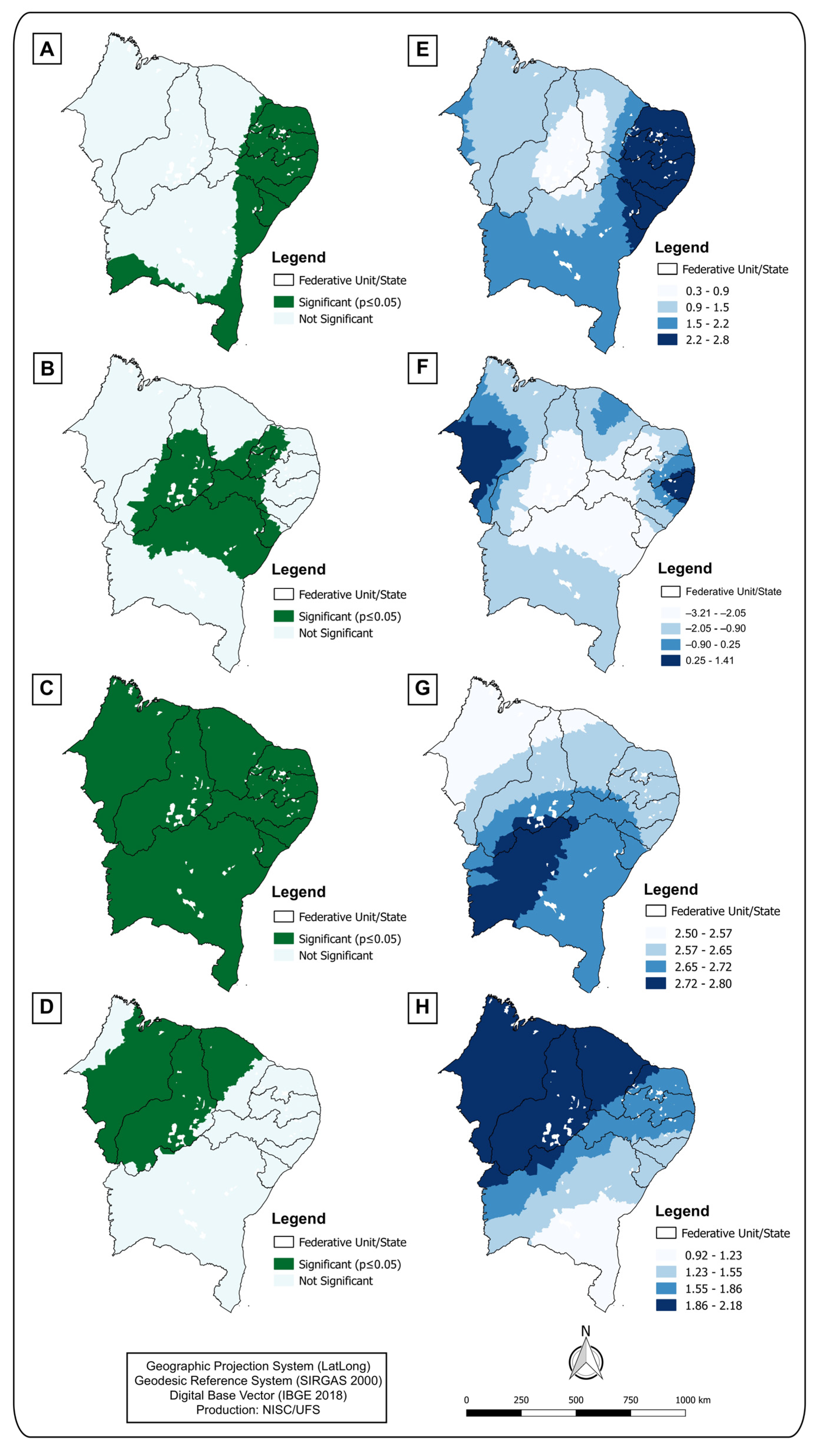
This study used secondary data from the public domain that did not contain any personal identification, and it followed the national and international ethical recommendations, including the rules of the Helsinki Convention and Resolution 466/2012 of the National Health Council (NHC).

3. Results

In the one-year period of the COVID-19 pandemic, 2,831,857 cases occurred in the Northeast Region of Brazil. The incidence rate was 4938.09/100,000 inhabitants. The states with the highest number of cases were Bahia (n = 778,617), Ceará (n = 508,832), and Pernambuco (n = 341,249). The highest incidence rate was recorded in Sergipe (7349.12/100,000 inhabitants), and the lowest in the state of Maranhão (3360.37/100,000 inhabitants) (Table 1).
The spatial analysis showed that COVID-19 cases were widely distributed across the states in the Northeast Region. A total of 136 municipalities had gross incidence rates higher than 8000/100,000 inhabitants (Figure 2A). These rates were smoothed using the local empirical Bayesian method, and Moran’s global index showed significant spatial autocorrelation (I = 0.349; p value < 0.001), demonstrating the existence of spatial dependence (Figure 2B). Using LISA, we identified the clusters of high risk of incidence, which comprised 187 municipalities located in the following states: Bahia (53), Rio Grande do Norte (36), Paraíba (27), Ceará (26), Piauí (24), Sergipe (11), Maranhão (9), and Pernambuco (1) (Figure 2C).
Table 2 shows the Spearman’s correlations between SDH and the incidence of COVID-19, which were statistically significant. We found that the SDH related to income, education, and housing inequality had a moderate correlation with the outcome, indicating the need to apply regression models.
The global regression models identified the predictive factors for the incidence of COVID-19 in the Northeast Region. However, when we included the spatial component, we observed that spatial lag was the best-fitting model. Among the predictor variables, the Gini index (a statistical measure used to quantify the degree of economic inequality by pointing out the difference between the incomes of the poorest and the richest) (R2 = −0.78; p < 0.01), the percentage of people in households vulnerable to poverty (R2 = 0.69; p < 0.01), and the dependency ratio (R2 = −0.60; p = 0.03) were used (Table 3).
As shown in Table 4, the SDH presented a VIF < 10, indicating low multicollinearity in the OLS model.
In the GWMR model, we observed that the fit was improved compared to the global regression models. The R2 increased to 0.59 (p = 0.01), the AICc decreased (2000.87), and the residuals were also controlled (IMG = −0.09; p = 0.09). The model selected the following variables as predictors based on the local level of association: Gini index (p < 0.01), percentage of poverty (p = 0.01), illiteracy rate (p = 0.03), and percentage of people in households vulnerable to poverty and dependent on elderly adults (p = 0.02) (Table 5).
Figure 3 shows the results of the GWMR as thematic maps that show the influence of SDH on the incidence of COVID-19 in the Northeast Region of Brazil. The municipalities located in the states of Rio Grande do Norte, Paraíba, Pernambuco, Alagoas, Sergipe, and Bahia showed significant (Figure 3A) and positive (Figure 3E) coefficients, demonstrating that the higher the percentage of poverty, the higher the incidence of COVID-19 will be. For the Gini index SDH, we found a significant association (Figure 3B) in the municipalities in the subregion of the hinterland and east of the states of Rio Grande do Norte, Paraíba, and Pernambuco; the central-southern region of the state of Sergipe; northern Bahia; southern Ceará; and the mesoregion of Piauí. However, we found SDH that had positive coefficients in some municipalities and negative coefficients in others (Figure 3F). The illiteracy rate had a significant association in the vast majority of municipalities in the Northeast (Figure 3C), and this association was positive (Figure 3E). The percentage of people in households vulnerable to poverty and dependent on elderly adults was a determining factor of the incidence of COVID-19 in the municipalities located in the states of Piauí, Ceará, and Maranhão (Figure 3D), and this association was positive (Figure 3H).

4. Discussion

This study analyzed the spatial pattern of COVID-19 incidence and its association with SDH in the municipalities in Northeast Brazil from a syndemic perspective. We identified 2,831,857 cases and an incidence rate of 4938.09/100,000 inhabitants. COVID-19 represented a serious public health problem in the Northeast Region, which had the highest incidence and mortality rates in Brazil [15].
The spatial analysis revealed a wide and heterogeneous distribution of COVID-19 in the Northeast Region. We found a spatial pattern of high incidence of COVID-19 in 187 municipalities in Northeast Brazil, located in the states of Bahia, Rio Grande do Norte, Paraíba, Ceará, Piauí, Sergipe, Maranhão, and Pernambuco. The findings of our study revealed that the Gini index, percentage of poverty, illiteracy rate, and percentage of people in households vulnerable to poverty and dependent on elderly adults were predictive of high incidence rates of COVID-19.
The results reinforce the syndemic theory, which considers the synergistic effects of the interactions between biological processes and social, economic, and power inequalities that shape the health–disease process in a society. These factors should be considered in order to improve the management of and strategic approaches toward local and global public health measures.
The interactions among poverty, social and income inequality, unemployment, education level, and housing have been documented as a determinant of COVID-19 [24]. Corroborating the results of the present study, a systematic review showed that groups of vulnerable populations, particularly racial minorities and low-income residents, are more susceptible to and have been disproportionately affected by COVID-19. Furthermore, the pandemic exacerbated existing social inequities through job loss and social disparities that led to a lack of access to healthcare and housing instability, for example. In Brazil, the Gini index is an important indicator for evaluating social and income inequality, and the higher this index is, the higher the incidence of COVID-19 [25].
In the Northeast Region, higher mortality due to COVID-19 was found to be related to the higher prevalence of comorbidities and lower socioeconomic development in these regions [26]. However, our study revealed an intriguing finding of a negative correlation between the Gini index and the incidence of COVID-19. Specifically, we observed that regions with higher income inequality exhibited lower rates of COVID-19 incidence. We hypothesized that this counterintuitive relationship could potentially be attributed to the presence of underreporting and difficulties in accessing diagnostic tests within these vulnerable areas, which may have inadvertently obscured the true extent of the pandemic.
In turn, in Sergipe, the smallest state in Brazil, an increasing trend of COVID-19 mortality was identified in people with high social vulnerability [27]. The high incidence of COVID-19 in municipalities with high social vulnerability shows that the disease has undergone an internalization process in which the number of fatal cases is higher in poorer municipalities [11].
Regions with socially unequal populations, such as the Northeast Region, have greater exposure to SARS-CoV-2 contamination due to poor housing and basic sanitation, which hinder hygiene and, consequently, the prevention of the disease [28]. The poor reach of health services, low educational levels, and the condition of Brazilian public transport deter social distancing and may signal elements leading to increased virus transmission [29]. In addition, housing conditions further aggravate the lethality of COVID-19 in the large peripheral areas [30].
The influence of SDH allows an understanding of the severe epidemiological scenario of COVID-19 in the Northeast Region of Brazil. In addition, it makes it possible to analyze COVID-19 not only as a pandemic that spread rapidly to different continents but also as a fundamental part of a syndemic process that needs to be understood as multicausal. Responses to major global problems must be quick and timely considering the interspersed aspects of public management and must consider the living conditions in which people are inserted, which influence the entire health and disease process [31].
In the face of the pandemic, the development of vaccines against SARS-CoV-2 was essential for the prevention and containment of viral transmission, consequently reducing the morbidity and mortality caused by the infection. With the small amount of immunobiologicals available, the WHO defined and guided countries to establish priority groups for vaccination against COVID-19, taking into account those with increased risk of developing severe infection and death, such as the elderly and individuals with certain comorbidities.
Even with the advances observed in the control of COVID-19, mainly resulting from mass vaccination, the course of the pandemic is still uncertain, as are the health responses in its different contexts. With COVID-19 becoming endemic, a series of actions will be required based on the implementation of effective prevention and control measures, such as epidemiological surveillance, vaccination, and health education, to prevent possible epidemics. Notably, for the planning of these actions, the syndemic aspect must be considered, and populations living in socioeconomic vulnerability must be prioritized because, due to the social situation in which they find themselves, they are more exposed and vulnerable to infection by the virus.
It is necessary to search for strategies that integrate the various conditions and determinants that make up the complex causality of coping with SARS-CoV-2, valuing the socio-environmental aspects of this process. Governments must take measures to mitigate the negative effects of COVID-19 and protect the most vulnerable groups, mainly from the minimization of existing social inequalities. In this sense, the development of public policies, greater allocation of investments and resources in critical areas, and greater articulation between different public entities are essential for adequate infection control and reduction of morbidity and mortality in socioeconomically disadvantaged regions.
SDH are associated with the greatest impact caused by COVID-19 in different regions [32]. In a country of continental dimensions with important structural differences and high social disparities such as Brazil, SARS-CoV-2 tends to cause impacts in different proportions, usually related to the socioeconomic level of the population [10]. Our findings provide evidence for improving coping strategies and prioritizing the allocation of resources and investments in the most critical areas, considering the social aspects of the health–disease process and, therefore, reducing the number of cases and fatal outcomes.
The limitations of the study consist of the impossibility of inferring a causal link due to the ecological fallacy, as well as the possible underreporting of cases based on public domain data and the possibility of time bias in the SDH information obtained. Furthermore, it is imperative to underscore that the national databases lacked pertinent data regarding the availability and accessibility of diagnostic tests across various regions of the country. This inherent limitation renders it impossible to accurately assess the extent to which access to these tests influenced the incidence rates and, consequently, the mortality rates attributed to COVID-19 during the initial year of the pandemic in Brazil. However, the findings of this study make it possible to identify the areas with the greatest risk of COVID-19 transmission through the analysis of its association with SDH.

5. Conclusions

In conclusion, the Gini index, illiteracy rate, percentage of poverty, and percentage of people in households vulnerable to poverty and dependent on elderly adults are social determinants of a higher incidence of COVID-19 in Northeast Brazil. The results of this study may contribute to generating new hypotheses for studies focusing on the syndemic process and for the formulation of intersectoral public policies targeting the population at greatest vulnerability to minimize the impact of the disease.

Author Contributions

J.C.d.S.A.: conceptualization, data curation, investigation, methodology, software, writing—original draft. C.J.N.R.: data curation, investigation, methodology, writing—review and editing. S.V.M.A.L.: data curation, validation, writing—review and editing. Á.F.L.d.S.: validation, writing—review and editing. G.S.M.: data curation, investigation, software, methodology. L.A.A.: data curation, software, validation. K.A.N.C.: investigation, methodology, writing—review and editing. M.B.S., D.d.C.A.: investigation, methodology, writing—review and editing. A.D.d.S.: conceptualization, data curation, investigation, methodology, software, writing—review and editing, supervision, validation. All authors have read and agreed to the published version of the manuscript.

Funding

This research received no external funding.

Institutional Review Board Statement

Not applicable.

Informed Consent Statement

Not applicable.

Data Availability Statement

The data used to support this study are included in this paper.

Conflicts of Interest

The authors declare no conflict of interest.

References

  1. Zhou, F.; Yu, T.; Du, R.; Fan, G.; Liu, Y.; Liu, Z.; Xiang, J.; Wang, Y.; Song, B.; Gu, X.; et al. Clinical Course and Risk Factors for Mortality of Adult Inpatients with COVID-19 in Wuhan, China: A Retrospective Cohort Study. Lancet 2020, 395, 1054–1062. [Google Scholar] [CrossRef] [PubMed]
  2. Ministério da Saúde (BR). Ministério da Saúde Declara Transmissão Comunitária Nacional. Brasil: Ministério da Saúde. 2020. Available online: https://www.gov.br/saude/pt-br/assuntos/noticias/ministerio-da-saude-declara-transmissao-comunitaria-nacional (accessed on 10 March 2022).
  3. Johns Hopkins University (JHU). Coronavirus Resource Center. United States: JHU. 2021. Available online: https://coronavirus.jhu.edu/ (accessed on 10 March 2022).
  4. Ministério da Saúde (BR). Coronavírus Brasil. Brasil: Ministério da Saúde. 2021. Available online: https://covid.saude.gov.br/ (accessed on 10 March 2022).
  5. Almeida Andrade, L.; Silva da Paz, W.; Fontes Lima, A.G.C.; da Conceição Araújo, D.; Duque, A.M.; Peixoto, M.V.S.; Góes, M.A.O.; Freire de Souza, C.D.; Nunes Ribeiro, C.J.; Almeida Lima, S.V.M.; et al. Spatiotemporal Pattern of COVID-19–Related Mortality during the First Year of the Pandemic in Brazil: A Population-Based Study in a Region of High Social Vulnerability. Am. J. Trop. Med. Hyg. 2022, 106, 132–141. [Google Scholar] [CrossRef] [PubMed]
  6. Mansouritorghabeh, H.; Bagherimoghaddam, A.; Eslami, S.; Raouf-Rahmati, A.; Hamer, D.H.; Kiani, B.; MohammadEbrahimi, S. Spatial Epidemiology of COVID-19 Infection through the First Outbreak in the City of Mashhad, Iran. Spat. Inf. Res. 2022, 30, 585–595. [Google Scholar] [CrossRef]
  7. Hohl, A.; Delmelle, E.M.; Desjardins, M.R.; Lan, Y. Daily Surveillance of COVID-19 Using the Prospective Space-Time Scan Statistic in the United States. Spat. Spatiotemporal. Epidemiol. 2020, 34, 100354. [Google Scholar] [CrossRef] [PubMed]
  8. Gravlee, C.C. Systemic Racism, Chronic Health Inequities, and COVID-19: A Syndemic in the Making? Am. J. Hum. Biol. 2020, 32, e23482. [Google Scholar] [CrossRef] [PubMed]
  9. Rafael, R.d.M.R.; Neto, M.; Depret, D.G.; Gil, A.C.; Fonseca, M.H.S.; Souza-Santos, R. Effect of Income on the Cumulative Incidence of COVID-19: An Ecological Study. Rev. Lat. Am. Enferm. 2020, 28, e3344. [Google Scholar] [CrossRef] [PubMed]
  10. de Souza, C.D.F.; Machado, M.F.; do Carmo, R.F. Human Development, Social Vulnerability and COVID-19 in Brazil: A Study of the Social Determinants of Health. Infect. Dis. Poverty 2020, 9, 124. [Google Scholar] [CrossRef] [PubMed]
  11. Baggio, J.A.O.; Machado, M.F.; Carmo, R.F.d.; Armstrong, A.d.C.; Santos, A.D.d.; Souza, C.D.F.d. COVID-19 in Brazil: Spatial Risk, Social Vulnerability, Human Development, Clinical Manifestations and Predictors of Mortality—A Retrospective Study with Data from 59 695 Individuals. Epidemiol. Infect. 2021, 149, e100. [Google Scholar] [CrossRef] [PubMed]
  12. Instituto Brasileiro de Geografia e Estatística (IBGE). Portal Cidades. Rio de Janeiro: IBGE. 2021. Available online: https://cidades.ibge.gov.br (accessed on 10 March 2022).
  13. Programa das Nações Unidas para o Desenvolvimento (PNUD). Atlas do Desenvolvimento Humano. Brasil: PNUD. 2010. Available online: https://www.br.undp.org/ (accessed on 12 March 2022).
  14. Instituto de Pesquisa Econômica Aplicada (IPEA). Atlas da Vulnerabilidade Social. Brasil: IPEA. 2021. Available online: http://www.atlasbrasil.org.br/ (accessed on 10 March 2022).
  15. Ministério da Saúde (MS). Painel Coronavírus. Brasília: MS. 2021. Available online: https://covid.saude.gov.br/ (accessed on 10 March 2022).
  16. Assunção, R.M.; Barreto, S.M.; Guerra, H.L.; Sakurai, E. Mapas de taxas epidemiológicas: Uma abordagem Bayesiana. Cad. Saude Publica 1998, 14, 713–723. [Google Scholar] [CrossRef] [PubMed]
  17. Anselin, L.; Florax, R.J.G.M. Small Sample Properties of Tests for Spatial Dependence in Regression Models: Some Further Results; Springer: Berlin/Heidelberg, Germany, 1995; pp. 21–74. [Google Scholar] [CrossRef]
  18. Zuur, A.F.; Ieno, E.N.; Smith, G.M. Analysing Ecological Data; Springer: New York, NY, USA, 2007. [Google Scholar] [CrossRef] [Green Version]
  19. Magalhães, M.d.A.F.M.; Medronho, R.d.A. Análise Espacial Da Tuberculose No Rio de Janeiro No Período de 2005 a 2008 e Fatores Socioeconômicos Associados Utilizando Microdado e Modelos de Regressão Espaciais Globais. Cien. Saude Colet. 2017, 22, 831–840. [Google Scholar] [CrossRef] [PubMed]
  20. Anselin, L. Exploring Spatial Data with GeoDa: A Workbook; Centre for Spatially Integrated Social Science: Santa Barbara, CA, USA, 2005. [Google Scholar]
  21. Charlton, M.; Fotheringham, S.; Brunsdon, C. Geographically Weighted Regression; ESRC National Centre for Research Methods: Maynooth, UK, 2005. [Google Scholar]
  22. Oshan, T.; Li, Z.; Kang, W.; Wolf, L.; Fotheringham, A. Mgwr: A Python Implementation of Multiscale Geographically Weighted Regression for Investigating Process Spatial Heterogeneity and Scale. ISPRS Int. J. Geo-Inf. 2019, 8, 269. [Google Scholar] [CrossRef] [Green Version]
  23. QGIS Team Development. QGIS: A free and Open Source Geographic Information System. 2021. Available online: https://qgis.org/pt_BR/site/, (accessed on 10 March 2022).
  24. Burström, B.; Tao, W. Social Determinants of Health and Inequalities in COVID-19. Eur. J. Public Health 2020, 30, 617–618. [Google Scholar] [CrossRef] [PubMed]
  25. Raymundo, C.E.; Oliveira, M.C.; Eleuterio, T.d.A.; André, S.R.; da Silva, M.G.; Queiroz, E.R.d.S.; Medronho, R.d.A. Spatial Analysis of COVID-19 Incidence and the Sociodemographic Context in Brazil. PLoS ONE 2021, 16, e0247794. [Google Scholar] [CrossRef] [PubMed]
  26. Baqui, P.; Bica, I.; Marra, V.; Ercole, A.; van der Schaar, M. Ethnic and Regional Variations in Hospital Mortality from COVID-19 in Brazil: A Cross-Sectional Observational Study. Lancet Glob. Health 2020, 8, e1018–e1026. [Google Scholar] [CrossRef] [PubMed]
  27. Gomes, D.S.; Andrade, L.A.; Ribeiro, C.J.N.; Peixoto, M.V.S.; Lima, S.V.M.A.; Duque, A.M.; Cirilo, T.M.; Góes, M.A.O.; Lima, A.G.C.F.; Santos, M.B.; et al. Risk Clusters of COVID-19 Transmission in Northeastern Brazil: Prospective Space–Time Modelling. Epidemiol. Infect. 2020, 148, e188. [Google Scholar] [CrossRef] [PubMed]
  28. Maciel, J.A.C.; Castro-Silva, I.I.; Farias, M.R.d. Análise Inicial Da Correlação Espacial Entre a Incidência de COVID-19 e o Desenvolvimento Humano Nos Municípios Do Estado Do Ceará No Brasil. Rev. Bras. Epidemiol. 2020, 23, e200057. [Google Scholar] [CrossRef] [PubMed]
  29. Daspett Mendonça, F.; Soares Rocha, S.; Pimenta Pinheiro, D.L.; Vilges de Oliveira, S. Região Norte Do Brasil e a Pandemia de COVID-19: Análise Socioeconômica e Epidemiológica. J. Health NPEPS 2020, 5, 20–37. [Google Scholar] [CrossRef]
  30. Instituto Brasileiro de Geografia e Estatística (IBGE). Pesquisa Nacional por Amostra de Domicílios Contínua COVID-19. Rio de Janeiro: IBGE. 2020. Available online: https://www.ibge.gov.br/estatisticas/sociais/rendimento-despesa-e-consumo/9171-pesquisa-nacional-por-amostra-de-domicilios-continua-mensal.html (accessed on 10 March 2022).
  31. Horton, R. Offline: COVID-19 Is Not a Pandemic. Lancet 2020, 396, 874. [Google Scholar] [CrossRef] [PubMed]
  32. Smith, J.A.; Judd, J. COVID-19: Vulnerability and the Power of Privilege in a Pandemic. Health Promot. J. Aust. 2020, 31, 158–160. [Google Scholar] [CrossRef] [PubMed] [Green Version]
Figure 1. Study area. (A) Northeast Region of Brazil; (B) Maranhão—MA; (C) Piauí—PI; (D) Ceará—CE; (E) Rio Grande do Norte—RN; (F) Paraíba—PB; (G) Pernambuco—PE; (H) Alagoas—AL; (I) Sergipe—SE; (J) Bahia—BA.
Covid 03 00067 g001
Figure 2. Spatial analysis of the incidence of COVID-19 in the Northeast Region of Brazil, 2020–2021. (A) Gross incidence rate; (B) Smoothed incidence rate; (C) Local Moran’s index (LISA).
Covid 03 00067 g002
Figure 3. Estimated relationships between SDH parameters and the incidence of COVID-19 according to the GWMR. Northeast Brazil, 2020–2021. (A,E) Percentage of poverty, (B,F) Gini index, (C,G) illiteracy rate, (D,H) percentage of people in households vulnerable to poverty and dependent on elderly adults.
Covid 03 00067 g003
Table 1. Incidence of cumulative cases of COVID-19 during the first year of the pandemic in the Northeast Region of Brazil, 2020–2021.
StateConfirmed CasesPopulationIncidence Rate
(per 100,000 Inhabitants)
Alagoas150,3643,351,5434486.41
Sergipe170,4132,318,8227349.12
Rio Grande do Norte191,7523,534,1655425.67
Piauí198,6643,281,4806054.10
Maranhão239,0777,114,5983360.37
Paraíba252,8894,039,2776260.75
Pernambuco341,2499,616,6213548.53
Ceará508,8329,187,1035538.55
Bahia778,61714,930,6345214.90
Total2,831,85757,347,2434938.09
Table 2. Association between the incidence of COVID-19 and SDH in the Northeast Region of Brazil, 2020–2021.
Social Determinants of HealthRhop
Percentage of poverty0.65<0.01
Gini index−0.57<0.01
Percentage of people living in households vulnerable to poverty and who spend more than one hour commuting to work0.50<0.01
Activity rate—25 to 29 years of age0.500.02
Municipal Human Development Index (MHDI) income−0.500.01
Percentage of people who are employed without income−0.500.02
Ratio of the richest 10% to the poorest 40%0.490.05
Percentage of people in households vulnerable to poverty and dependent on elderly adults0.480.01
Dependency ratio−0.470.02
Illiteracy rate0.350.01
Percentage of employed persons with complete secondary education0.330.01
Municipal Human Development Index Education (MHDI Education): school attendance sub-index−0.290.01
Percentage of people in households with inadequate water supply and sanitation0.280.02
Table 3. OLS and spatial lag regression models for the relationship between the incidence of COVID-19 and SDH in the Northeast Region of Brazil, 2020–2021.
Social Determinants of HealthOLS ModelSpatial Lag Model
CoefficientpCoefficientp
Gini index−0.93<0.01−0.78<0.01
Percentage of people in households that are vulnerable to poverty and who spend more than 1 h commuting to work0.70<0.010.69<0.01
Dependency ratio−0.670.04−0.600.03
Percentage of poverty0.55<0.010.480.03
Activity rate—25 to 29 years of age0.500.010.460.01
MHDI Income−0.48<0.010.120.06
Ratio of the richest 10% to the poorest 40%0.440.040.070.08
Percentage of people employed without income−0.400.02−0.310.04
Illiteracy rate0.25<0.010.18<0.01
Percentage of employed people with a complete secondary education0.23<0.010.19<0.01
Percentage of people in households vulnerable to poverty and dependent on elderly adults0.22<0.010.190.01
MHDI Education: school attendance sub-index−0.190.01−0.900.02
Percentage of people in households with inadequate water supply and sanitation0.180.03−0.210.03
Criteria for evaluating the model
AIC2629.79 2319.71
BIC2729.78 2444.93
Log-likelihood−1292.89 −1136.66
Coefficient of determination (R2)0.25 (p = 0.01) 0.41 (p = 0.01)
Global Moran’s index of the regression residual0.29 (p = 0.00) −0.25 (p = 0.34)
Table 4. Variation inflation factor of the variables included in the OLS model. Northeast Region of Brazil, 2020–2021.
Social Determinants of HealthVIF
Gini index1.227
Percentage of people in households vulnerable to poverty and those who spend more than one hour commuting to work1.222
Dependency ratio1.127
Percentage of poverty1.017
Activity rate—25 to 29 years of age1.345
MHDI Income2.019
Ratio of the richest 10% to the poorest 40%1.217
Percentage of people employed without income1.014
Illiteracy rate2.001
Percentage of employed people with a complete secondary education1.037
Percentage of people in households vulnerable to poverty and dependent on elderly adults1.004
MHDI Education: school attendance sub-index1.421
Percentage of people in households with inadequate water supply and sanitation2.567
Table 5. Local spatial regression of the relationship between the incidence of COVID-19 and SDH in the Northeast Region of Brazil, 2020–2021.
Social Determinants of HealthGWMR
Mean Z Score Estimates
Gini index<0.01
Percentage of poverty0.01
Illiteracy rate0.03
Percentage of people in households vulnerable to poverty and dependent on elderly adults0.02
Criteria for evaluating the model
AICc2000.87
BIC2234.70
Coefficient of determination (R2)0.59 (p = 0.01)
Global Moran’s index of the regression residual0.09 (p = 0.09)
Disclaimer/Publisher’s Note: The statements, opinions and data contained in all publications are solely those of the individual author(s) and contributor(s) and not of MDPI and/or the editor(s). MDPI and/or the editor(s) disclaim responsibility for any injury to people or property resulting from any ideas, methods, instructions or products referred to in the content.

