
GIS Open-Source Plugins Development: A 10-Year Bibliometric Analysis on Scientific Literature


Abstract
:1. Introduction
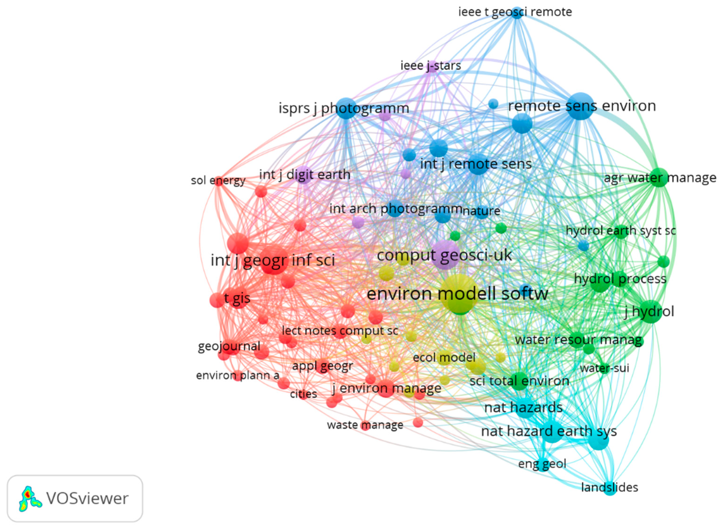
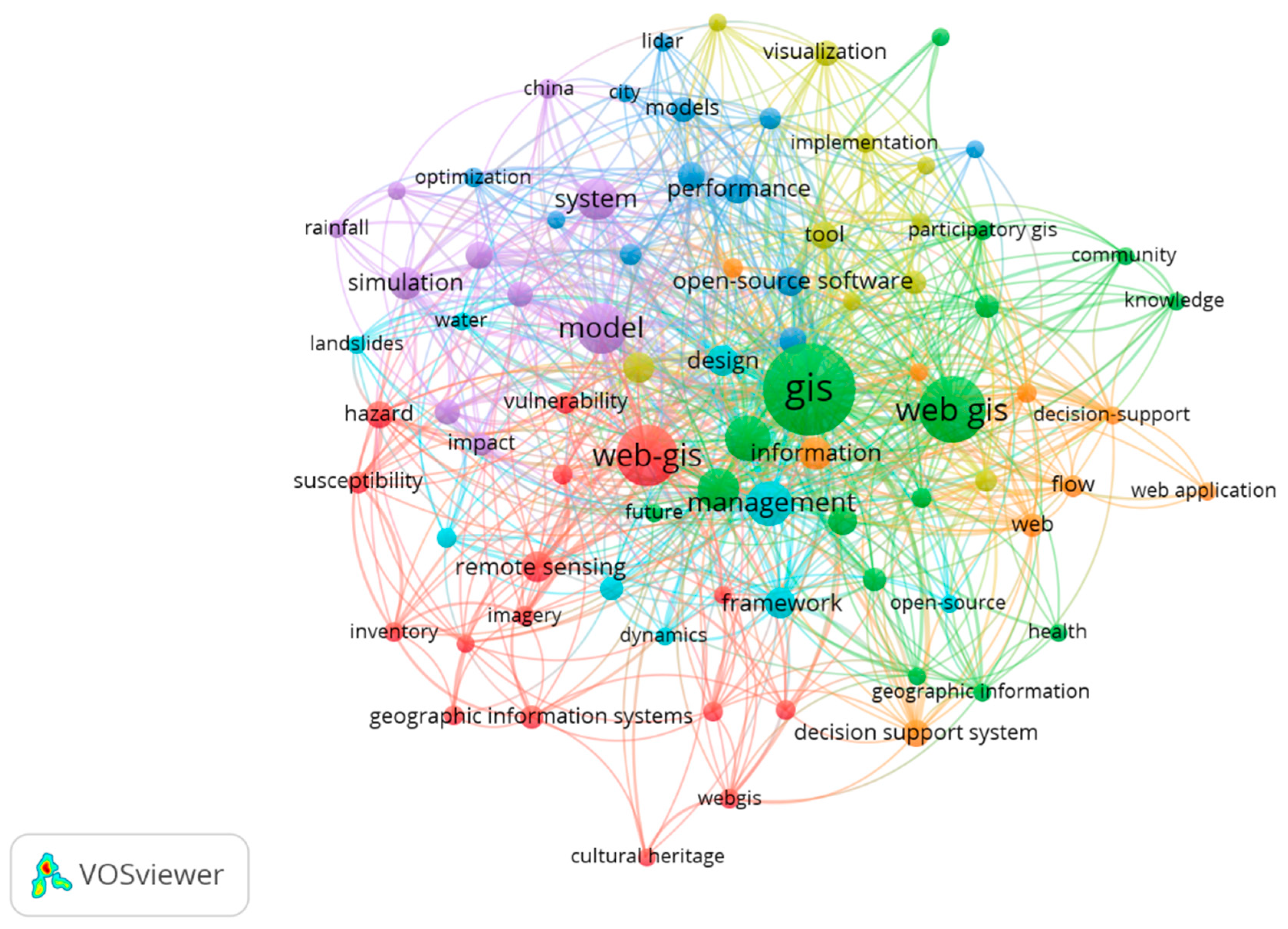
2. Bibliographic Analysis
3. GIS Open-Source Desktop Applications
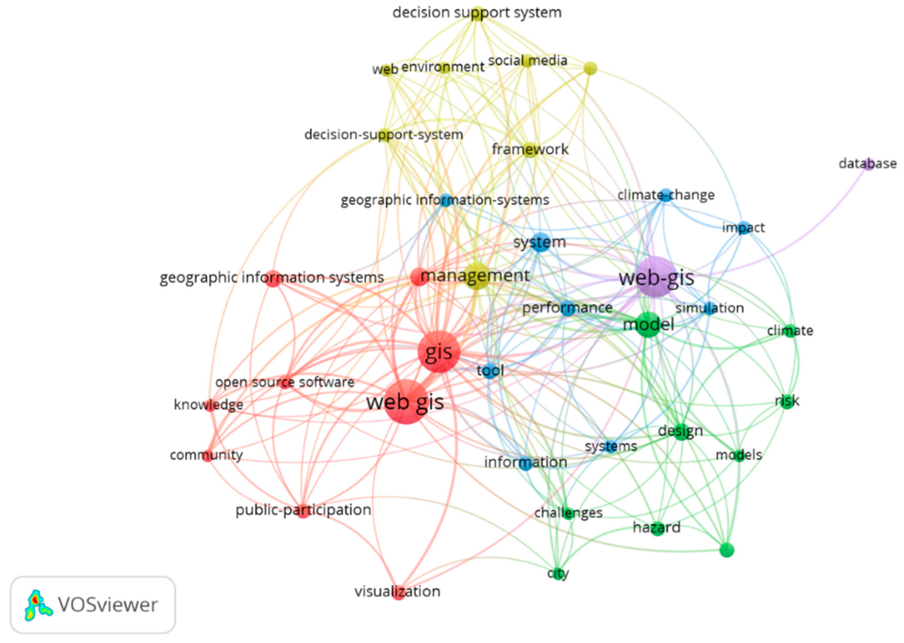
4. Web GIS Applications
5. GIS Mobile Applications
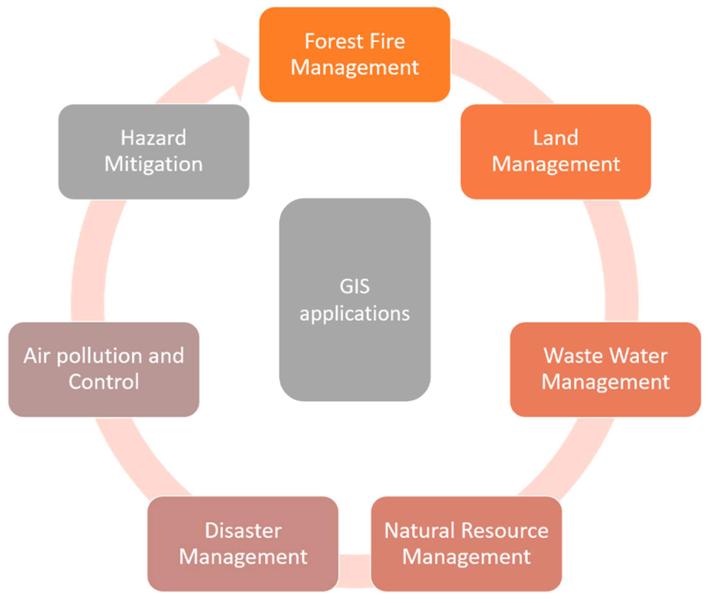
6. Environmental GIS Applications
7. Future Trends of GIS in Environmental Sciences
8. Conclusions
Author Contributions
Funding
Institutional Review Board Statement
Informed Consent Statement
Data Availability Statement
Conflicts of Interest
Appendix A

| Authors | Publisher | Journal Name | Publication Year | DOY |
|---|---|---|---|---|
| Morgan, JD; Eddy, B; Coffey, JW | ROUTLEDGE JOURNALS, TAYLOR & FRANCIS LTD | J. Geogr. High. Educ. | 10.1080/03098265.2020.1852200 | |
| Rowland, A; Folmer, E; Beek, W | MDPI | ISPRS Int. Geo-Inf. | 2020 | 10.3390/ijgi9120753 |
| Muller, AL; Gericke, OJ; Pietersen, JPJ | SAICE-SAISI | J. S. Afr. Inst. Civ. Eng. | 2020 | 10.17159/2309-8775/2020/v62n4a4 |
| Adedeji, O; Olusola, A; James, G; Shaba, HA; Orimoloye, IR; Singh, SK; Adelabu, S | SPRINGER | Environ. Monit. Assess. | 2020 | 10.1007/s10661-020-08730-3 |
| Casadei, S; Peppoloni, F; Pierleoni, A | MDPI | Water | 2020 | 10.3390/w12113227 |
| Geyer, NR; Kessler, FC; Lengerich, EJ | MDPI | ISPRS Int. Geo-Inf. | 2020 | 10.3390/ijgi9110619 |
| Muller, MM; Vila-Vilardell, L; Vacik, H | ELSEVIER | Ecol. Inform. | 2020 | 10.1016/j.ecoinf.2020.101151 |
| Zhang, MD; Jiang, LC; Yue, P; Gong, JY | ELSEVIER SCI LTD | Environ. Modell. Softw. | 2020 | 10.1016/j.envsoft.2020.104838 |
| Perucchetti, L; Bray, P; Felicetti, A; Sainsbury, V; Howarth, P; Saunders, MK; Hommel, P; Pollard, M | WILEY | Archaeometry | 10.1111/arcm.12616 | |
| Walker, JD; Letcher, BH; Rodgers, KD; Muhlfeld, CC; D’Angelo, VS | MDPI | Water | 2020 | 10.3390/w12102928 |
| Sanchez-Aparicio, LJ; Masciotta, MG; Garcia-Alvarez, J; Ramos, LF; Oliveira, DV; Martin-Jimenez, JA; Gonzalez-Aguilera, D; Monteiro, P | ELSEVIER | Autom. Constr. | 2020 | 10.1016/j.autcon.2020.103304 |
| Farnaghi, M; Mansourian, A | ELSEVIER SCI LTD | Cities | 2020 | 10.1016/j.cities.2020.102850 |
| Anderson, SL; Murray, SC | FRONTIERS MEDIA SA | Front. Plant Sci. | 2020 | 10.3389/fpls.2020.511768 |
| Schattschneider, JL; Daudt, NW; Mattos, MPS; Bonetti, J; Rangel-Buitrago, N | SPRINGER | Environ. Monit. Assess. | 2020 | 10.1007/s10661-020-08602-w |
| Liang, JM; Gong, JH; Xie, XP; Sun, J | MDPI | ISPRS Int. Geo-Inf. | 2020 | 10.3390/ijgi9090524 |
| Yamamoto, K | MDPI | Information | 2020 | 10.3390/info11090434 |
| Zhang, XW; Yang, Y; Zhang, Y; Zhang, ZL | PERGAMON-ELSEVIER SCIENCE LTD | Ann. Touris. Res. | 2020 | 10.1016/j.annals.2020.102999 |
| Cardoso, MA; Almeida, MC; Brito, RS; Gomes, JL; Beceiro, P; Oliveira, A | WILEY | J. Flood Risk Manag. | 2020 | 10.1111/jfr3.12663 |
| Paul, M; Bussemaker, MJ | ELSEVIER SCI LTD | J. Clean Prod. | 2020 | 10.1016/j.jclepro.2020.121461 |
| Caliskan, M; Anbaroglu, B | ELSEVIER | SoftwareX | 2020 | 10.1016/j.softx.2020.100553 |
| Sardella, A; Palazzi, E; von Hardenberg, J; Del Grande, C; De Nuntiis, P; Sabbioni, C; Bonazza, A | MDPI | Atmosphere | 2020 | 10.3390/atmos11070700 |
| Kalinka, M; Geipele, S; Pudzis, E; Lazdins, A; Krutova, U; Holms, J | MDPI | Sustainability | 2020 | 10.3390/su12135293 |
| Beyhan, B; Guler, C; Taga, H | SPRINGER HEIDELBERG | J. Geogr. Syst. | 2020 | 10.1007/s10109-020-00325-3 |
| Mauro, N; Ardissono, L; Lucenteforte, M | ELSEVIER SCI LTD | Inf. Process. Manage. | 2020 | 10.1016/j.ipm.2020.102257 |
| Agrawal, S; Gupta, RD | SPRINGER HEIDELBERG | Arab. J. Geosci. | 2020 | 10.1007/s12517-020-05490-9 |
| Moniz, PF; Almeida, JS; Pino, AT; Rivero, JPS | ROUTLEDGE JOURNALS, TAYLOR & FRANCIS LTD | Water Int. | 2020 | 10.1080/02508060.2020.1765130 |
| De Filippis, G; Stevenazzi, S; Camera, C; Pedretti, D; Masetti, M | SPRINGER | Hydrogeol. J. | 2020 | 10.1007/s10040-020-02176-0 |
| Golzio, A; Bollati, IM; Luciani, M; Pelfini, M; Ferrarese, S | MDPI | Appl. Sci.-Basel | 2020 | 10.3390/app10124243 |
| Mussa, KR; Mjemah, IC; Machunda, RL | MDPI | Hydrology | 2020 | 10.3390/hydrology7020028 |
| Possenti, L; Savini, L; Conte, A; D’Alterio, N; Danzetta, ML; Di Lorenzo, A; Nardoia, M; Migliaccio, P; Tora, S; Dalla Villa, P | MDPI | Animals | 2020 | 10.3390/ani10060983 |
| Butt, MA; Khalid, A; Ali, A; Mahmood, SA; Sami, J; Qureshi, J; Waheed, K | SPRINGER HEIDELBERG | Appl. Geomat. | 2020 | 10.1007/s12518-019-00282-7 |
| Bittner, D; Rychlik, A; Kloffel, T; Leuteritz, A; Disse, M; Chiogna, G | ELSEVIER SCI LTD | Environ. Modell. Softw. | 2020 | 10.1016/j.envsoft.2020.104682 |
| Rakotoarison, HA; Rasamimalala, M; Rakotondramanga, JM; Ramiranirina, B; Franchard, T; Kapesa, L; Razafindrakoto, J; Guis, H; Tantely, LM; Girod, R; Rakotoniaina, S; Baril, L; Piola, P; Rakotomanana, F | MDPI | Remote Sens. | 2020 | 10.3390/rs12101585 |
| Razavi-Termeh, SV; Sadeghi-Niaraki, A; Choi, SM | MDPI | Remote Sens. | 2020 | 10.3390/rs12101689 |
| Giuffrida, S; Gagliano, F; Giannitrapani, E; Marisca, C; Napoli, G; Trovato, MR | MDPI | Sustainability | 2020 | 10.3390/su12104022 |
| Ghareeb, M; Seif, AK | SPRINGER INTERNATIONAL PUBLISHING AG | Innov. Infrastruct. Solut. | 2020 | 10.1007/s41062-020-00293-z |
| Zhang, SR; Hou, DJ; Wang, C; Pan, F; Yan, L | ELSEVIER | Autom. Constr. | 2020 | 10.1016/j.autcon.2020.103114 |
| Lin, NY; Chen, SP; Wang, SA; Yeh, C | EDINBURGH UNIV PRESS | Int. J. Humanit. Arts Comput. | 2020 | 10.3366/ijhac.2020.0246 |
| Filocamo, F; Di Paola, G; Mastrobuono, L; Rosskopf, CM | MDPI | Resources-Basel | 2020 | 10.3390/resources9030031 |
| Kodaka, A; Kawasaki, A; Shirai, N; Acierto, RA; Zin, WW; Kohtake, N | FUJI TECHNOLOGY PRESS LTD | J. Disaster Res. | 2020 | 10.20965/jdr.2020.p0312 |
| Jakimow, B; van der Linden, S; Thiel, F; Frantz, D; Hostert, P | ELSEVIER SCI LTD | Environ. Modell. Softw. | 2020 | 10.1016/j.envsoft.2020.104631 |
| Nemoto, T; Masumoto, S; Raghavan, V; Nonogaki, S; Nakada, F | SPRINGER SINGAPORE PTE LTD | Spat. Inf. Res. | 2020 | 10.1007/s41324-020-00321-1 |
| Dhiman, R; VishnuRadhan, R; Inamdar, AB; Eldho, I | SPRINGER | J. Coast. Conserv. | 2020 | 10.1007/s11852-020-00734-y |
| Sejati, AW; Buchori, I; Rudiarto, I; Silver, C; Sulistyo, K | BUCHAREST UNIV PRESS | J. Urban Reg. Anal. | 2020 | 10.37043/JURA.2020.12.1.2 |
| Frolov, A | STATE ACAD UNIV HUMANITIES | Istoriya | 2020 | 10.18254/S207987840012436-8 |
| Stoddart, R; Godfrey, B | UNIV ALBERTA | Evid. Based Lib. Inf. Pract. | 2020 | 10.18438/eblip29721 |
| Puttinaovarat, S; Horkaew, P | TAYLOR & FRANCIS LTD | Geomat. Nat. Hazards Risk | 2020 | 10.1080/19475705.2020.1815869 |
| Dong, YY; Xu, F; Liu, LY; Du, XP; Ren, BY; Guo, AT; Geng, Y; Ruan, C; Ye, HC; Huang, WJ; Zhu, YN | IEEE-INST ELECTRICAL ELECTRONICS ENGINEERS INC | IEEE J. Sel. Top. Appl. Earth Observ. Remote Sens. | 2020 | 10.1109/JSTARS.2020.3013340 |
| Kostrikov, SV; Bubnov, DY; Pudlo, RA | V N KARAZIN KHARKIV NATL UNIV | Visn. V N Karazin Kharkiv Natl. Univ.-Ser. Geol Geogr. Ecol. | 2020 | 10.26565/2410-7360-2020-52-12 |
| Schwindt, S; Larrieu, K; Pasternack, GB; Rabone, G | ELSEVIER | SoftwareX | 2020 | 10.1016/j.softx.2020.100438 |
| Ishida, T; Li, HY | INDERSCIENCE ENTERPRISES LTD | Int. J. Web Grid Serv. | 2020 | |
| Czernecki, B; Glogowski, A; Nowosad, J | MDPI | Sustainability | 2020 | 10.3390/su12010394 |
| Afnarius, S; Akbar, F; Yuliani, F | MDPI | ISPRS Int. Geo-Inf. | 2020 | 10.3390/ijgi9010052 |
| Feng, QY; Flanagan, DC; Engel, BA; Yang, L; Chen, LD | ELSEVIER SCI LTD | Environ. Modell. Softw. | 2020 | 10.1016/j.envsoft.2019.104569 |
| Li, LQ; Ju, NP; He, C; Li, CL; Sheng, DC | SPRINGER HEIDELBERG | Landslides | 2020 | 10.1007/s10346-019-01307-3 |
| Jelokhani-Niaraki, M | TAYLOR & FRANCIS LTD | J. Decis. Syst. | 2019 | 10.1080/12460125.2019.1698898 |
| Nevistic, Z; Spoljaric, D | SCIENDO | GeoScape | 2019 | 10.2478/geosc-2019-0011 |
| Farkas, G | UNIV TORONTO PRESS INC | Cartographica | 2019 | 10.3138/cart.54.4.2018-0014 |
| Sallwey, J; Schlick, R; Valverde, JPB; Junghanns, R; Lopez, FV; Stefan, C | MDPI | Water | 2019 | 10.3390/w11112254 |
| Hoover, B; Yaw, S; Middleton, R | TAYLOR & FRANCIS LTD | Int. J. Geogr. Inf. Sci. | 2020 | 10.1080/13658816.2019.1675885 |
| Ishida, T; Hoshino, S | EMERALD GROUP PUBLISHING LTD | Int. J. Web Inf. Syst. | 2019 | 10.1108/IJWIS-09-2018-0068 |
| Rahmati, O; Kalantari, Z; Samadi, M; Uuemaa, E; Moghaddam, DD; Nalivan, OA; Destouni, G; Bui, DT | MDPI | Sustainability | 2019 | 10.3390/su11205639 |
| Kulawiak, M | ELSEVIER | Data Brief | 2019 | 10.1016/j.dib.2019.104507 |
| Voda, M; Graves, S; Berariu, CE | CLUJ UNIV PRESS | Geogr. Tech. | 2019 | 10.21163/GT_2019.142.13 |
| Quinn, S | TAYLOR & FRANCIS LTD | Int. J. Geogr. Inf. Sci. | 2020 | 10.1080/13658816.2019.1665672 |
| Singh, H; Garg, RD; Karnatak, HC | SPRINGER HEIDELBERG | Earth Sci. Inform. | 2019 | 10.1007/s12145-019-00378-z |
| Zhang, XQ; Zhong, M; Liu, SB; Zheng, LH; Chen, YM | MDPI | ISPRS Int. Geo-Inf. | 2019 | 10.3390/ijgi8090364 |
| Lee, S; Panahi, M; Pourghasemi, HR; Shahabi, H; Alizadeh, M; Shirzadi, A; Khosravi, K; Melesse, AM; Yekrangnia, M; Rezaie, F; Moeini, H; Pham, BT; Bin Ahmad, B | MDPI | Appl. Sci.-Basel | 2019 | 10.3390/app9173495 |
| Sismanidis, P; Keramitsoglou, I; Barberis, S; Dorotic, H; Bechtel, B; Kiranoudis, CT | MDPI | Remote Sens. | 2019 | 10.3390/rs11172048 |
| Lentini, V; Distefano, G; Castelli, F | SPRINGER HEIDELBERG | Bull. Eng. Geol. Environ. | 2019 | 10.1007/s10064-018-1390-7 |
| Mangiameli, M; Mussumeci, G; Roccaro, P; Vagliasindi, FGA | SPRINGER HEIDELBERG | Appl. Geomat. | 2019 | 10.1007/s12518-019-00265-8 |
| Aghajani, D; Abbaspour, M; Radfar, R; Mohammadi, A | SPRINGER | Int. J. Environ. Sci. Technol. | 2019 | 10.1007/s13762-018-2091-2 |
| Rossetto, R; De Filippis, G; Triana, F; Ghetta, M; Borsi, I; Schmid, W | ELSEVIER | Agric. Water Manage. | 2019 | 10.1016/j.agwat.2019.105717 |
| Kaya, E; Agca, M; Adiguzel, F; Cetin, M | TAYLOR & FRANCIS INC | Hum. Ecol. Risk Assess. | 2019 | 10.1080/10807039.2018.1470896 |
| Dabove, P | PATRON EDITORE S R L | Geam-Geoint. Ambient. Min. | 2019 | |
| Mirshafiei, P; Sadeghi-Niaraki, A; Shakeri, M; Choi, SM | MDPI | Water | 2019 | 10.3390/w11081736 |
| Narra, P; Coelho, C; Sancho, F | ELSEVIER SCI LTD | Ocean Coastal Manage. | 2019 | 10.1016/j.ocecoaman.2019.104845 |
| Kulawiak, M; Dawidowicz, A; Pacholczyk, ME | PERGAMON-ELSEVIER SCIENCE LTD | Comput. Geosci. | 2019 | 10.1016/j.cageo.2019.04.011 |
| Choosumrong, S; Humhong, C; Raghavan, V; Fenoy, G | SPRINGER SINGAPORE PTE LTD | Spat. Inf. Res. | 2019 | 10.1007/s41324-019-00248-2 |
| Zou, ZQ; Cai, T; Cao, K | SAGE PUBLICATIONS LTD | Env. Plan. B-Urban Anal. CIty Sci. | 2020 | 10.1177/2399808319862292 |
| Pathak, S; Garg, RD; Jato-Espino, D; Lakshrni, V; Ojha, CSP | ACADEMIC PRESS LTD- ELSEVIER SCIENCE LTD | J. Environ. Manage. | 2019 | 10.1016/j.jenvman.2019.04.082 |
| Horton, P | COPERNICUS GESELLSCHAFT MBH | Geosci. Model Dev. | 2019 | 10.5194/gmd-12-2915-2019 |
| She, B; Hu, T; Zhu, XY; Bao, SM | TAYLOR & FRANCIS LTD | Geo-Spat. Inf. Sci. | 2019 | 10.1080/10095020.2019.1645497 |
| Kreklow, J | IWA PUBLISHING | J. Hydroinform. | 2019 | 10.2166/hydro.2019.048 |
| Siles, G; Charland, A; Voirin, Y; Benie, GB | ELSEVIER SCIENCE BV | Ecol. Inform. | 2019 | 10.1016/j.ecoinf.2019.05.011 |
| Mavroulis, S; Andreadakis, E; Spyrou, NI; Antoniou, V; Skourtsos, E; Papadimitriou, P; Kasssaras, I; Kaviris, G; Tselentis, GA; Voulgaris, N; Carydis, P; Lekkas, E | ELSEVIER | Int. J. Disaster Risk Reduct. | 2019 | 10.1016/j.ijdrr.2019.101169 |
| Hansen, BD; Dahlhaus, PG; Milne, RG; MacLeod, AD; Pitfield, C | TAYLOR & FRANCIS INC | Soc. Nat. Resour. | 2019 | 10.1080/08941920.2018.1559383 |
| Lafrance, F; Daniel, S; Dragicevic, S | MDPI | ISPRS Int. Geo-Inf. | 2019 | 10.3390/ijgi8060253 |
| Muenchow, J; Schafer, S; Kruger, E | WILEY | Geogr. Compass | 2019 | 10.1111/gec3.12441 |
| Dolce, M; Speranza, E; Giordano, F; Borzi, B; Bocchi, F; Conte, C; Di Meo, A; Faravelli, M; Pascale, V | IST NAZIONALE DI OCEANOGRAFIA E DI GEOFISICA | Boll. Geofis. Teor. Appl. | 2019 | 10.4430/bgta0254 |
| Daras, G; Agard, B; Penz, B | SPRINGER VIEWEG-SPRINGER FACHMEDIEN WIESBADEN GMBH | Bus. Inf. Syst. Eng. | 2019 | 10.1007/s12599-018-0548-y |
| Matney, JA; Slocumb, WS; Smith, JW; Bonsall, P; Supak, SK | SAGAMORE PUBL LLC | J. Park Recreat. Adm. | 2019 | 10.18666/JPRA-2019-9250 |
| Bakibinga, P; Kabaria, C; Kyobutungi, C; Manyara, A; Mbaya, N; Mohammed, S; Njeri, A; Azam, I; Iqbal, R; Mazaffar, S; Rizvi, N; Rizvi, T; Rehman, HU; Ahmed, SAKS; Aiam, O; Khan, AZ; Rahman, O; Yusuf, R; Odubanjo, D; Ayobola, M; Fayehun, F; Omigbodun, A; Owoaje, E; Taiwo, O; Diggle, P; Aujia, N; Chen, YF; Gill, P; Griffiths, F; Harris, B; Madan, J; Lilford, RJ; Oyobode, OR; Pitidis, V; de Albequerque, JP; Sartori, J; Taylor, C; Ulbrich, P; Uthman, O; Watson, SI; Yeboah, G | BMC | BMC Med. Res. Methodol. | 2019 | 10.1186/s12874-019-0732-x |
| Frantz, D | MDPI | Remote Sens. | 2019 | 10.3390/rs11091124 |
| Kim, IH; Pow, CP; Wang, YC; Feng, CC | WILEY | Singap. J. Trop. Geogr. | 2019 | 10.1111/sjtg.12263 |
| Fayne, JV; Ahamed, A; Roberts-Pierel, J; Rumsey, AC; Kirschbaum, D | AMER GEOPHYSICAL UNION | Earth Interact. | 2019 | 10.1175/EI-D-17-0022.1 |
| Das, K; Pramanik, D; Santra, SC; Sengupta, S | ELSEVIER | Egypt. J. Remote Sens. Space Sci. | 2019 | 10.1016/j.ejrs.2018.10.002 |
| Goncalves, J; Pocas, I; Marcos, B; Mucher, CA; Honrado, JP | ELSEVIER | Int. J. Appl. Earth Obs. Geoinf. | 2019 | 10.1016/j.jag.2018.11.011 |
| Kulawiak, M; Kulawiak, M; Lubniewski, Z | MDPI | ISPRS Int. Geo-Inf. | 2019 | 10.3390/ijgi8030144 |
| Beyhan, B | ACAD SCI CZECH REPUBLIC, INST GEONICS | Morav. Geogr. Rep. | 2019 | 10.2478/mgr-2019-0002 |
| Vaitis, M; Feidas, H; Symeonidis, P; Kopsachilis, V; Dalaperas, D; Koukourouvli, N; Simos, D; Taskaris, S | SPRINGER HEIDELBERG | Earth Sci. Inform. | 2019 | 10.1007/s12145-018-0351-9 |
| De Donatis, M; Pappafico, GF; Romeo, RW | MDPI | ISPRS Int. Geo-Inf. | 2019 | 10.3390/ijgi8020091 |
| Kalpakis, V; Kokkos, N; Pisinaras, V; Sylaios, G | SPRINGER | J. Coast. Conserv. | 2019 | 10.1007/s11852-018-0646-5 |
| Kaku, K | ELSEVIER SCIENCE BV | Int. J. Disaster Risk Reduct. | 2019 | 10.1016/j.ijdrr.2018.09.015 |
| Singh, H; Karnatak, HC; Garg, RD | TAYLOR & FRANCIS LTD | Geocarto Int. | 2019 | 10.1080/10106049.2017.1381178 |
| Alberi, M; Baldoncini, M; Bottardi, C; Chiarelli, E; Landsberger, S; Raptis, KGC; Serafini, A; Strati, V; Mantovani, F | MDPI | Educ. Sci. | 2019 | 10.3390/educsci9010015 |
| Jayawardhana, UK; Gorsevski, PV | TAYLOR & FRANCIS LTD | Int. J. Digit. Earth | 2019 | 10.1080/17538947.2017.1411535 |
| Montagnetti, R; Rosati, P | EDIZIONI ALL INSEGNA GIGLIO SAS-ITALIAN NATL RESEARCH COUNC | Archeol. Calc. | 2019 | |
| Mariotti, S | EDIZIONI ALL INSEGNA GIGLIO SAS-ITALIAN NATL RESEARCH COUNC | Archeol. Calc. | 2019 | |
| Palombini, A; Fanini, B | EDIZIONI ALL INSEGNA GIGLIO SAS-ITALIAN NATL RESEARCH COUNC | Archeol. Calc. | 2019 | |
| Beconyte, G; Snezko, J; Balciunas, A; Vidugiryte-Pakeriene, I | TAYLOR & FRANCIS LTD | Cartogr. J. | 2019 | 10.1080/00087041.2018.1533292 |
| Montagnetti, R; Chiraz, PP; Ricci, A; Pickel, DG | ARCHEOMATICA | Archeomatica | 2019 | |
| Yermakov, V; Lunova, O; Averin, D | OLES GONCHAR DNIPRO NATL UNIV | J. Geol. Geogr. Geoecol. | 2019 | 10.15421/111957 |
| Calugaru, A; Leu, P; Damalan, A; Mihai, D | UNIV AGRICULTURAL SCIENCES & VETERINARY MEDICINE BUCHAREST | Sci. Pap.-Ser. E-Land Reclam. Earth Obs. Surv. Environ. Eng. | 2019 | |
| Idarraga, SAC; Vanegas, CED; Gomez, DMM | TECNOLOGICO ANTIOQUIA-INST UNIV, FAC INGENIERIA | Cuad. Act. | 2019 | |
| Sappa, G; Ferranti, F | PAGEPRESS PUBL | Acque Sotter. | 2019 | 10.7343/as-2019-372 |
| Onida, M; Faravelli, M; Gotti, A; Sarigiannis, D | PARLAR SCIENTIFIC PUBLICATIONS (P S P) | Fresenius Environ. Bull. | 2019 | |
| Alkazemi, BY | SCIENCE & INFORMATION SAI ORGANIZATION LTD | Int. J. Adv. Comput. Sci. Appl. | 2019 | |
| Laquidara, M | SAGE PUBLICATIONS INC | Transp. Res. Record | 2018 | 10.1177/0361198118780834 |
| Ahmed, B; Rahman, MS; Islam, R; Sammonds, P; Zhou, C; Uddin, K; Al-Hussaini, TM | MDPI | ISPRS Int. Geo-Inf. | 2018 | 10.3390/ijgi7120485 |
| Albano, R; Sole, A; Adamowski, J; Perrone, A; Inam, A | ELSEVIER SCIENCE BV | Int. J. Appl. Earth Obs. Geoinf. | 2018 | 10.1016/j.jag.2018.06.019 |
| Dawidowicz, A; Kulawiak, M | TAYLOR & FRANCIS LTD | Surv. Rev. | 2018 | 10.1080/00396265.2017.1328331 |
| Gordov, EP; Okladnikov, IG; Titov, AG; Voropay, NN; Ryazanova, AA; Lykosov, VN | PLEIADES PUBLISHING INC | Russ. Meteorol. Hydrol. | 2018 | 10.3103/S106837391811002X |
| Oxoli, D; Molinari, ME; Brovelli, MA | SOC GEOLOGICA ITALIANA | Rend. Online Soc. Geol. Ital. | 2018 | 10.3301/ROL.2018.56 |
| Jan, JF | MDPI | ISPRS Int. Geo-Inf. | 2018 | 10.3390/ijgi7110426 |
| Liu, ZP; Du, GM; Cai, J; Zhou, F; Liu, J; Bian, K | SCIENCE PRESS | Rock Soil Mech. | 2018 | 10.16285/j.rsm.2017.0221 |
| Jeong, JS; Gonzalez-Gomez, D | ASOC ESPANOLA CIENCIA REGIONAL-AECR | Investig. Reg. | 2018 | |
| Rossetto, R; De Filippis, G; Borsi, I; Foglia, L; Cannata, M; Criollo, R; Vazquez-Sune, E | ELSEVIER SCI LTD | Environ. Modell. Softw. | 2018 | 10.1016/j.envsoft.2018.06.007 |
| Rauter, M; Kofler, A; Huber, A; Fellin, W | COPERNICUS GESELLSCHAFT MBH | Geosci. Model Dev. | 2018 | 10.5194/gmd-11-2923-2018 |
| Walter, SHG; Muller, JP; Sidiropoulos, P; Tao, Y; Gwinner, K; Putri, ARD; Kim, JR; Steikert, R; van Gasselt, S; Michael, GG; Watson, G; Schreiner, BP | AMER GEOPHYSICAL UNION | Earth Space Sci. | 2018 | 10.1029/2018EA000389 |
| McCord, P; Tonini, F; Liu, JG | ELSEVIER SCI LTD | Appl. Geogr. | 2018 | 10.1016/j.apgeog.2018.05.001 |
| Stefan, C; Ansems, N | SPRINGER INTERNATIONAL PUBLISHING AG | Sustain. Wat. Resour. Manag. | 2018 | 10.1007/s40899-017-0212-6 |
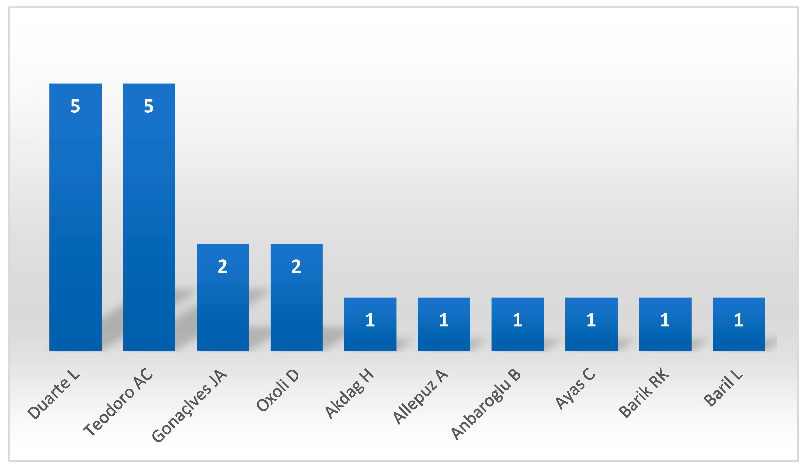
| Correia, R; Duarte, L; Teodoro, AC; Monteiro, A | MDPI | Educ. Sci. | 2018 | 10.3390/educsci8020083 |
| Koo, H; Chun, Y; Griffith, DA | WILEY | Trans. GIS | 2018 | 10.1111/tgis.12452 |
| Piedelobo, L; Ortega-Terol, D; del Pozo, S; Hernandez-Lopez, D; Ballesteros, R; Moreno, MA; Molina, JL; Gonzalez-Aguilera, D | MDPI | ISPRS Int. Geo-Inf. | 2018 | 10.3390/ijgi7060220 |
| Leroux, C; Jones, H; Pichon, L; Guillaume, S; Lamour, J; Taylor, J; Naud, O; Crestey, T; Lablee, JL; Tisseyre, B | MDPI | Agriculture-Basel | 2018 | 10.3390/agriculture8060073 |
| Seguel, IAR; Quezada, CAR; Contreras, HEDF; Reyes, PZV | UNIV BIO-BIO, DEPT PLANIFICACION & DISENO | Urbano | 2018 | 10.22320/07183607.2018.21.37.03 |
| Kim, J | COASTAL EDUCATION & RESEARCH FOUNDATION | J. Coast. Res. | 2018 | 10.2112/SI85-299.1 |
| Zhang, N; Jin, S; Ai, CF; Ding, WY | IWA PUBLISHING | J. Hydroinform. | 2018 | 10.2166/hydro.2017.113 |
| Rovithis, E; Makra, K; Kirtas, E; Manesis, C; Bliziotis, D; Konstantinidou, K | EARTHQUAKE ENGINEERING RESEARCH INST | Earthq. Spectra | 2018 | 10.1193/052917EQS098DP |
| Yakubailik, OE; Kadochnikov, AA; Tokarev, AV | SPRINGER | Optoelectron. Instrum. Data Proc. | 2018 | 10.3103/S8756699018030056 |
| Mileu, N; Queiros, M | MDPI | ISPRS Int. Geo-Inf. | 2018 | 10.3390/ijgi7050184 |
| Bock, M; Conrad, O; Gunther, A; Gehrt, E; Baritz, R; Bohner, J | COPERNICUS GESELLSCHAFT MBH | Geosci. Model Dev. | 2018 | 10.5194/gmd-11-1641-2018 |
| Evangelidis, K; Papadopoulos, T | MDPI | Geosciences | 2018 | 10.3390/geosciences8040139 |
| Jager, D; Kreuzer, T; Wilde, M; Bemm, S; Terhorst, B | ELSEVIER SCIENCE BV | Geomorphology | 2018 | 10.1016/j.geomorph.2015.10.008 |
| Duarte, L; Silva, P; Teodoro, AC | MDPI | ISPRS Int. Geo-Inf. | 2018 | 10.3390/ijgi7030109 |
| Borsch, S; Khristoforov, A; Krovotyntsev, V; Leontieva, E; Simonov, Y; Zatyagalova, V | MDPI | Geosciences | 2018 | 10.3390/geosciences8030093 |
| Yaqot, M; Trigunarsyah, B | ICE PUBLISHING | Infrastruct. Asset Manag. | 2018 | 10.1680/jinam.17.00009 |
| Vacca, G; Fiorino, DR; Pili, D | MDPI | ISPRS Int. Geo-Inf. | 2018 | 10.3390/ijgi7020049 |
| Liao, M; Qian, XL | UNIV OSIJEK, TECH FAC | Teh. Vjesn. | 2018 | 10.17559/TV-20170601094307 |
| Casadei, S; Pierleoni, A; Bellezza, M | MDPI | Sustainability | 2018 | 10.3390/su10020485 |
| Tang, JY; Matyas, CJ | PERGAMON-ELSEVIER SCIENCE LTD | Comput. Geosci. | 2018 | 10.1016/j.cageo.2017.11.011 |
| Quill, T; Djenno, M | ROUTLEDGE JOURNALS, TAYLOR & FRANCIS LTD | J. Map Geogr. Libr. | 2018 | 10.1080/15420353.2018.1628500 |
| Godfrey, B; Stoddart, R | AMER LIBRARY ASSOC | Inf. Technol. Libr. | 2018 | 10.6017/ital.v37i2.10208 |
| Kulawiak, M; Chybicki, A | TAYLOR & FRANCIS INC | Mar. Geod. | 2018 | 10.1080/01490419.2018.1469557 |
| Van Cauwenbergh, N; Ciuro, AB; Ahlers, R | RESILIENCE ALLIANCE | Ecol. Soc. | 2018 | 10.5751/ES-09987-230202 |
| Castelli, F; Lentini, V; Ferraro, A; Grasso, S | IST NAZIONALE DI GEOFISICA E VULCANOLOGIA | Ann. Geophys. | 2018 | 10.4401/ag-7705 |
| Fonte, CC; Fontes, D; Cardoso, A | KASSEL UNIV PRESS GMBH | Int. J. Online Eng. | 2018 | 10.3991/ijoe.v14i02.8191 |
| Siles, G; Voirin, Y; Benie, GB | ELSEVIER SCIENCE BV | Ecol. Inform. | 2018 | 10.1016/j.ecoinf.2017.11.005 |
| Falco, E; Malavolta, I; Radzimski, A; Ruberto, S; Iovino, L; Gallo, F | ROUTLEDGE JOURNALS, TAYLOR & FRANCIS LTD | J. Urban Technol. | 2018 | 10.1080/10630732.2017.1362901 |
| Kunapo, J; Fletcher, TD; Ladson, AR; Cunningham, L; Burns, MJ | TAYLOR & FRANCIS LTD | Urban Water J. | 2018 | 10.1080/1573062X.2018.1424216 |
| Ahlqvist, O; Khodke, N; Ramnath, R | ELSEVIER SCI LTD | Comput. Environ. Urban Syst. | 2018 | 10.1016/j.compenvurbsys.2017.08.013 |
| Phuong, NH; Nam, NT; Truyen, PT | VIETNAM ACAD SCIENCE & TECHNOLOGY-VAST | Vietnam J. Earth Sci. | 2018 | 10.15625/0866-7187/40/3/12638 |
| Voutos, Y; Mylonas, P; Spyrou, E; Charou, E | MDPI AG | J. Sens. Actuar. Netw. | 2017 | 10.3390/jsan6040027 |
| Karnatak, HC; Singh, H; Garg, RD | NATL ACAD SCIENCES INDIA | Proc. Nat. Acad. Sci. India A | 2017 | 10.1007/s40010-017-0442-x |
| Agrawal, S; Gupta, RD | SPRINGER HEIDELBERG | Arab. J. Geosci. | 2017 | 10.1007/s12517-017-3296-2 |
| Hamylton, SM | SAGE PUBLICATIONS LTD | Prog. Phys. Geogr. | 2017 | 10.1177/0309133317744998 |
| Mikovits, C; Tscheikner-Gratl, F; Jasper-Tonnies, A; Einfalt, T; Huttenlau, M; Schopf, M; Kinzel, H; Rauch, W; Kleidorfer, M | ASCE-AMER SOC CIVIL ENGINEERS | J. Water Resour. Plan. Manage.-ASCE | 2017 | 10.1061/(ASCE)WR.1943-5452.0000840 |
| Huang, J; Buchanan, SM; Bishop, TFA; Triantafilis, J | WILEY | Soil Use Manage. | 2017 | 10.1111/sum.12383 |
| Castelli, F; Lentini, V; Grasso, S | SPRINGER | Bull. Earthq. Eng. | 2017 | 10.1007/s10518-017-0163-1 |
| Javadnejad, F; Gillins, DT; Higgins, CC; Gillins, MN | ASCE-AMER SOC CIVIL ENGINEERS | J. Comput. Civil. Eng. | 2017 | 10.1061/(ASCE)CP.1943-5487.0000710 |
| Arai, K | SCIENCE & INFORMATION SAI ORGANIZATION LTD | Int. J. Adv. Comput. Sci. Appl. | 2017 | |
| Jun, S; Lee, S | SPRINGER SINGAPORE PTE LTD | Spat. Inf. Res. | 2017 | 10.1007/s41324-017-0138-y |
| Mushongal, HT; Banda, F; Mulolwa, A | CONSAS CONFERENCE | S. Afr. J. Geomat. | 2017 | 10.4314/sajg.v6i3.4 |
| Barik, RK | IGI GLOBAL | Int. J. Agric. Environ. Inf. Syst. | 2017 | 10.4018/IJAEIS.2017100104 |
| Toschi, I; Nocerino, E; Remondino, F | REED BUSINESS-GEO | GIM Int. | 2017 | |
| Valensise, G; Tarabusi, G; Guidoboni, E; Ferrari, G | ELSEVIER SCIENCE BV | Int. J. Disaster Risk Reduct. | 2017 | 10.1016/j.ijdrr.2017.09.014 |
| Mizutani, Y; Yamamoto, K | MDPI AG | ISPRS Int. Geo-Inf. | 2017 | 10.3390/ijgi6100303 |
| Veenendaal, B; Brovelli, MA; Li, SN | MDPI AG | ISPRS Int. Geo-Inf. | 2017 | 10.3390/ijgi6100317 |
| He, YR; Zhang, DJ; Fang, YH | ELSEVIER SCIENCE BV | Int. J. Disaster Risk Reduct. | 2017 | 10.1016/j.ijdrr.2017.08.007 |
| Beccati, A; Gerken, J; Quast, C; Yilmaz, P; Glockner, FO | BIOMED CENTRAL LTD | BMC Bioinformatics | 2017 | 10.1186/s12859-017-1841-3 |
| Golly, A; Turowski, JM | COPERNICUS GESELLSCHAFT MBH | Earth Surf. Dyn. | 2017 | 10.5194/esurf-5-557-2017 |
| Lagmay, AMFA; Racoma, BA; Aracan, KA; Alconis-Ayco, J; Saddi, IL | SCIENCE PRESS | J. Environ. Sci. | 2017 | 10.1016/j.jes.2017.03.014 |
| Oxoli, D; Prestifilippo, G; Bertocchi, D; Zurbaran, M | PATRON EDITORE S R L | Geam-Geoint. Ambient. Min. | 2017 | |
| Baiocchi, V; Camuccio, P; Zagari, M; Ceglia, A; Del Gobbo, S; Purri, F; Cipollini, L; Mezzapesa, M; Liso, L; Vatore, F | PATRON EDITORE S R L | Geam-Geoint. Ambient. Min. | 2017 | |
| Moreri, KK; Maphale, L; Nkhwanana, N | SPRINGER SINGAPORE PTE LTD | Spat. Inf. Res. | 2017 | 10.1007/s41324-017-0123-5 |
| Gong, H; Simwanda, M; Murayama, Y | MDPI AG | ISPRS Int. Geo-Inf. | 2017 | 10.3390/ijgi6080257 |
| Ciolli, M; Federici, B; Ferrando, I; Marzocchi, R; Sguerso, D; Tattoni, C; Vitti, A; Zatelli, P | MDPI AG | ISPRS Int. Geo-Inf. | 2017 | 10.3390/ijgi6070225 |
| Farkas, G | SPRINGER HEIDELBERG | J. Geogr. Syst. | 2017 | 10.1007/s10109-017-0248-z |
| Nakayama, Y; Nakamura, K; Saito, H; Fukumoto, R | MDPI | Geosciences | 2017 | 10.3390/geosciences7020022 |
| Favretto, A; Callegher, B | UNIV TORONTO PRESS INC | Cartographica | 2017 | 10.3138/cart.52.2.3781 |
| Singh, YK; Dutta, U; Prabhu, TSM; Prabu, I; Mhatre, J; Khare, M; Srivastava, S; Dutta, S | MDPI | Hydrology | 2017 | 10.3390/hydrology4020030 |
| Harvey, AS; Fotopoulos, G; Hall, B; Amolins, K | PERGAMON-ELSEVIER SCIENCE LTD | Comput. Geosci. | 2017 | 10.1016/j.cageo.2017.02.008 |
| Calera, A; Campos, I; Osann, A; D’Urso, G; Menenti, M | MDPI | Sensors | 2017 | 10.3390/s17051104 |
| Olyazadeh, R; Sudmeier-Rieux, K; Jaboyedoff, M; Derron, MH; Devkota, S | COPERNICUS GESELLSCHAFT MBH | Nat. Hazards Earth Syst. Sci. | 2017 | 10.5194/nhess-17-549-2017 |
| Grippa, T; Lennert, M; Beaumont, B; Vanhuysse, S; Stephenne, N; Wolff, E | MDPI AG | Remote Sens. | 2017 | 10.3390/rs9040358 |
| Guenzi, D; Fratianni, S; Boraso, R; Cremonini, R | SPRINGER HEIDELBERG | Earth Sci. Inform. | 2017 | 10.1007/s12145-016-0278-y |
| Albano, R; Mancusi, L; Sole, A; Adamowski, J | TAYLOR & FRANCIS LTD | Geomat. Nat. Hazards Risk | 2017 | 10.1080/19475705.2017.1388854 |
| Willmes, C; Becker, D; Verheul, J; Yener, Y; Zickel, M; Bolten, A; Bubenzer, O; Bareth, G | EUROPEAN COMMISSION, JOINT RESEARCH CENTRE | Int. J. Spat. Data Infrastruct. Res. | 2017 | 10.2902/1725-0463.2017.12.art3 |
| Cavur, M; Duzgun, HS | TAYLOR & FRANCIS LTD | J. Spat. Sci. | 2017 | 10.1080/14498596.2016.1230837 |
| Tora, S; Sacchini, S; Listes, E; Bogdanovic, T; Di Lorenzo, A; Smajlovic, M; Smajlovic, A; Filipovic, JV; Tahirovic, V; Sukovic, D; Beljkas, B; Xinxo, A; Maci, R; Colangeli, P; Di Giacinto, F; Conte, A | UNIV NAPLES FEDERICO II | Geospatial Health | 2017 | 10.4081/gh.2017.593 |
| Hu, LJ; He, ZY; Liu, JP | TAYLOR & FRANCIS LTD | Cartogr. J. | 2017 | 10.1080/00087041.2016.1193273 |
| Marzocchi, R; Fagandini, R; Beggiato, L; Berti, E; Ardini, R; Freddo, N; Cosso, T; Missagia, M | MEDIAGEO SCIENCE & TECHNOLOGY PUBLISHING | GeoMedia | 2017 | |
| Ying, W | TEKNOSCIENZE PUBL | Agro Food Ind. Hi-Tech | 2017 | |
| Rahman, K; Ray, N; Giuliani, G; Maringanti, C; George, C; Lehmann, A | MAIK NAUKA/INTERPERIODICA/SPRINGER | Water Resour. | 2017 | 10.1134/S0097807817010067 |
| Tsai, CH | INDERSCIENCE ENTERPRISES LTD | Int. J. Comput. Appl. Technol. | 2017 | 10.1504/IJCAT.2017.082867 |
| Bernardoni, S; Montanari, M; Trojanis, R | EDIZIONI ALL INSEGNA GIGLIO SAS-ITALIAN NATL RESEARCH COUNC | Archeol. Calc. | 2017 | |
| Duarte, L; Teodoro, AC; Moutinho, O; Goncalves, JA | TAYLOR & FRANCIS LTD | Int. J. Remote Sens. | 2017 | 10.1080/01431161.2016.1259685 |
| Sante, I; Pacurucu, N; Boullon, M; Garcia, AM; Miranda, D | WILEY-BLACKWELL | Trans. GIS | 2016 | 10.1111/tgis.12223 |
| Lamastra, L; Balderacchi, M; Di Guardo, A; Monchiero, M; Trevisan, M | ELSEVIER | Sci. Total Environ. | 2016 | 10.1016/j.scitotenv.2016.07.043 |
| Chen, XN; Elmes, G; Ye, XY; Chang, JH | SPRINGER | GeoJournal | 2016 | 10.1007/s10708-016-9745-8 |
| Tao, Y; Muller, JP; Poole, W | ACADEMIC PRESS INC ELSEVIER SCIENCE | Icarus | 2016 | 10.1016/j.icarus.2016.06.017 |
| Fujita, S; Yamamoto, K | SCIENCE & INFORMATION SAI ORGANIZATION LTD | Int. J. Adv. Comput. Sci. Appl. | 2016 | |
| Liang, JM; Gong, JH; Liu, J; Zou, YL; Zhang, JM; Sun, J; Chen, SS | MDPI AG | ISPRS Int. Geo-Inf. | 2016 | 10.3390/ijgi5110212 |
| Dile, YT; Daggupati, P; George, C; Srinivasan, R; Arnold, J | ELSEVIER SCI LTD | Environ. Modell. Softw. | 2016 | 10.1016/j.envsoft.2016.08.004 |
| Yang, BY | ELSEVIER SCI LTD | Appl. Geogr. | 2016 | 10.1016/j.apgeog.2016.09.006 |
| Tan, XC; Di, LP; Deng, MX; Huang, F; Ye, XY; Sha, ZY; Sun, ZH; Gong, WS; Shao, YZ; Huang, C | ELSEVIER SCI LTD | Environ. Modell. Softw. | 2016 | 10.1016/j.envsoft.2016.07.001 |
| Morgan, JD | WILEY | Trans. GIS | 2016 | 10.1111/tgis.12197 |
| Lindsay, JB | PERGAMON-ELSEVIER SCIENCE LTD | Comput. Geosci. | 2016 | 10.1016/j.cageo.2016.07.003 |
| Suzuki, S | FUJI TECHNOLOGY PRESS LTD | J. Disaster Res. | 2016 | 10.20965/jdr.2016.p0935 |
| Estwick, NM; Griffin, RW; James, AA; Roberson, SG | UNIV OF WISCONSIN EXTENSION JOURNAL INC | J. Ext. | 2016 | |
| Chen, YF; Perrella, AML | UNIV TORONTO PRESS INC | Cartographica | 2016 | 10.3138/cart.51.3.3288 |
| Sofina, N; Ehlers, M | IEEE-INST ELECTRICAL ELECTRONICS ENGINEERS INC | IEEE J. Sel. Top. Appl. Earth Observ. Remote Sens. | 2016 | 10.1109/JSTARS.2016.2542074 |
| Aburizaiza, AO; Rice, MT | SPRINGER SINGAPORE PTE LTD | Spat. Inf. Res. | 2016 | 10.1007/s41324-016-0042-x |
| Zhou, JW; Yamamoto, K | SCIENCE & INFORMATION SAI ORGANIZATION LTD | Int. J. Adv. Comput. Sci. Appl. | 2016 | |
| Geri, F; La Porta, N; Zottele, F; Ciolli, M | MDPI AG | ISPRS Int. Geo-Inf. | 2016 | 10.3390/ijgi5070100 |
| Spekken, M; de Bruin, S; Molin, JP; Sparovek, G | ELSEVIER SCI LTD | Comput. Electron. Agric. | 2016 | 10.1016/j.compag.2016.03.013 |
| Duarte, L; Teodoro, AC; Goncalves, JA; Soares, D; Cunha, M | SPRINGER | Environ. Monit. Assess. | 2016 | 10.1007/s10661-016-5349-5 |
| Lee, CF; Huang, CM; Tsao, TC; Wei, LW; Huang, WK; Cheng, CT; Chi, CC | SOUTHEAST ASIAN GEOTECHNICAL SOC | Geotech. Eng. | 2016 | |
| Aye, ZC; Charriere, M; Olyazadeh, R; Derron, MH; Jaboyedoff, M | SPRINGER SINGAPORE PTE LTD | Spat. Inf. Res. | 2016 | 10.1007/s41324-016-0018-x |
| Olyazadeh, R; Aye, ZC; Jaboyedoff, M; Derron, MH | SPRINGER SINGAPORE PTE LTD | Spat. Inf. Res. | 2016 | 10.1007/s41324-016-0017-y |
| Tang, JY; Matyas, CJ | AMER METEOROLOGICAL SOC | J. Atmos. Ocean. Technol. | 2016 | 10.1175/JTECH-D-15-0118.1 |
| Kouziokas, GN | ELSEVIER SCIENCE BV | Environ. Technol. Innov. | 2016 | 10.1016/j.eti.2016.01.006 |
| Jenny, B; Savric, B; Liem, J | TAYLOR & FRANCIS LTD | Int. J. Digit. Earth | 2016 | 10.1080/17538947.2014.1002867 |
| Aye, ZC; Sprague, T; Cortes, VJ; Prenger-Berninghoff, K; Jaboyedoff, M; Derron, MH | ELSEVIER SCIENCE BV | Int. J. Disaster Risk Reduct. | 2016 | 10.1016/j.ijdrr.2015.12.001 |
| Sadler, JM; Ames, DP; Khattar, R | IWA PUBLISHING | J. Hydroinform. | 2016 | 10.2166/hydro.2015.092 |
| Doula, MK; Sarris, A; Hliaoutakis, A; Kydonakis, A; Papadopoulos, NS; Argyriou, L | SPRINGER | Environ. Monit. Assess. | 2016 | 10.1007/s10661-016-5139-0 |
| Peragon, JM; Delgado, A; Diaz, JAR; Perez-Latorre, FJ | ELSEVIER SCIENCE BV | Agric. Water Manage. | 2016 | 10.1016/j.agwat.2015.12.005 |
| Tayyebi, A; Meehan, TD; Dischler, J; Radloff, G; Ferris, M; Gratton, C | ELSEVIER SCI LTD | Comput. Electron. Agric. | 2016 | 10.1016/j.compag.2015.12.003 |
| Steiniger, S; Poorazizi, ME; Hunter, AJS | COGITATIO PRESS | Urban Plan. | 2016 | 10.17645/up.v1i2.607 |
| Varadharajan, RB; Pavel, T; Mohan, S | PENERBIT UTM PRESS | J. Teknol. | 2016 | |
| Jamhawi, MM; Hajahjah, ZA | UNIV AGEAN, DEPT MEDITERRANEAN STUD | Mediterr. Archaeol. Archaeom. | 2016 | 10.5281/zenodo.47541 |
| Myers, D; Dalgity, A; Avramides, I | EMERALD GROUP PUBLISHING LTD | J. Cult. Herit. Manag. Sustain. Dev. | 2016 | 10.1108/JCHMSD-02-2016-0010 |
| Attorre, F; Bonacquisti, S; Francesconi, F; Sambucini, V; Martellos, S | TAYLOR & FRANCIS LTD | Plant Biosyst. | 2016 | 10.1080/11263504.2016.1179230 |
| Ribeiro, AM; Sousa, V; Cardoso, A | KASSEL UNIV PRESS GMBH | Int. J. Online Eng. | 2016 | 10.3991/ijoe.v12i04.5261 |
| Aye, ZC; Jaboyedoff, M; Derron, MH; van Westen, CJ; Hussin, HY; Ciurean, RL; Frigerio, S; Pasuto, A | COPERNICUS GESELLSCHAFT MBH | Nat. Hazards Earth Syst. Sci. | 2016 | 10.5194/nhess-16-85-2016 |
| Yuksek, K; Alparslan, M; Mendi, E | COPERNICUS GESELLSCHAFT MBH | Nat. Hazards Earth Syst. Sci. | 2016 | 10.5194/nhess-16-123-2016 |
| Zinoviev, AT; Lovtskaya, OV; Baldakov, NA | L N GUMILYOV EURASIAN NATL UNIV | Eurasian J. Math. Comput. Appl. | 2016 | 10.32523/2306-6172-2016-4-3-39-50 |
| Pettygrove, MW; Ghose, R | IGI GLOBAL | Int. J. Appl. Geospat. Res. | 2016 | 10.4018/IJAGR.2016010102 |
| Banos, R; Wandosell, G; Parra, MC | EMERALD GROUP PUBLISHING LTD | J. Knowl. Manag. | 2016 | 10.1108/JKM-06-2015-0218 |
| Dolega, L; Pavlis, M; Singleton, A | ELSEVIER SCI LTD | J. Retail. Consum. Serv. | 2016 | 10.1016/j.jretconser.2015.08.013 |
| Kalabokidis, K; Ager, A; Finney, M; Athanasis, N; Palaiologou, P; Vasilakos, C | COPERNICUS GESELLSCHAFT MBH | Nat. Hazards Earth Syst. Sci. | 2016 | 10.5194/nhess-16-643-2016 |
| Afonin, AN; Sevryukov, SY; Solovyov, PA; Luneva, NN | ST PETERSBURG UNIV PRESS | Vestn. St. Petersb. Univ. Earth Sci. | 2016 | 10.21638/11701/spbu07.2016.408 |
| Biljecki, F; Heuvelink, GBM; Ledoux, H; Stoter, J | TAYLOR & FRANCIS LTD | Int. J. Geogr. Inf. Sci. | 2015 | 10.1080/13658816.2015.1073292 |
| Weng, Y; Cheng, WY | NADIA | Int. J. Grid Distrib. Comput. | 2015 | |
| Drypczewski, K; Stepnowski, A; Bruniecki, K | GDANSK UNIV TECHNOLOGY | Pol. Marit. Res. | 2015 | 10.1515/pomr-2015-0066 |
| Lichter, M; Grinberger, AY; Felsenstein, D | MDPI | ISPRS Int. Geo-Inf. | 2015 | 10.3390/ijgi4041827 |
| Yang, YJ; Sun, YQ; Li, SN; Zhang, SL; Wang, KY; Hou, HP; Xu, SS | MDPI | ISPRS Int. Geo-Inf. | 2015 | 10.3390/ijgi4042078 |
| Karashima, K; Ohgai, A; Tadamura, K | ELSEVIER | Front. Archit. Res. | 2015 | 10.1016/j.foar.2015.08.001 |
| Tarjuelo, JM; Rodriguez-Diaz, JA; Abadia, R; Camacho, E; Rocamora, C; Moreno, MA | ELSEVIER SCIENCE BV | Agric. Water Manage. | 2015 | 10.1016/j.agwat.2015.08.009 |
| Chakraborty, A; Wilson, B; Sarraf, S; Jana, A | ELSEVIER SCIENCE BV | J. Urban Manag. | 2015 | 10.1016/j.jum.2015.12.001 |
| Damm, B; Klose, M | ELSEVIER | Geomorphology | 2015 | 10.1016/j.geomorph.2015.03.021 |
| Poggio, L; Gimona, A | ELSEVIER SCI LTD | Spat. Stat. | 2015 | 10.1016/j.spasta.2015.04.006 |
| Zaragozi, B; Belda, A; Gimenez, P; Navarro, JT; Bonet, A | ELSEVIER SCIENCE BV | Ecol. Inform. | 2015 | 10.1016/j.ecoinf.2015.08.001 |
| Reed, D; Barr, WA; Mcpherron, SP; Bobe, R; Geraads, D; Wynn, JG; Alemseged, Z | WILEY | Evol. Anthropol. | 2015 | 10.1002/evan.21466 |
| Sidiropoulos, P; Muller, JP | PERGAMON-ELSEVIER SCIENCE LTD | Planet Space Sci. | 2015 | 10.1016/j.pss.2015.06.017 |
| Ota, M; Plews, R | TAYLOR & FRANCIS INC | Cartogr. Geogr. Inf. Sci. | 2015 | 10.1080/15230406.2015.1031701 |
| Delgado, F; Martinez, R; Puche, J; Finat, J | ELSEVIER | Comput. Ind. | 2015 | 10.1016/j.compind.2015.07.012 |
| Leidig, M; Teeuw, R | ELSEVIER | Int. J. Appl. Earth Obs. Geoinf. | 2015 | 10.1016/j.jag.2015.05.012 |
| Magyari-Saska, Z | CLUJ UNIV PRESS | Geogr. Tech. | 2015 | |
| Yamamoto, K; Fujita, S | SCIENCE & INFORMATION SAI ORGANIZATION LTD | Int. J. Adv. Comput. Sci. Appl. | 2015 | |
| Aye, ZC; Jaboyedoff, M; Derron, MH; van Westen, CJ | MDPI | ISPRS Int. Geo-Inf. | 2015 | 10.3390/ijgi4031201 |
| Duarte, L; Teodoro, AC; Goncalves, JA; Dias, AJG; Marques, JE | SPRINGER | Environ. Earth Sci. | 2015 | 10.1007/s12665-015-4222-0 |
| Musungu, K; Jacobs, D | CONSAS CONFERENCE | S. Afr. J. Geomat. | 2015 | 10.4314/sajg.v4i3.2 |
| Yue, P; Zhang, MD; Tan, ZY | ELSEVIER SCI LTD | Environ. Modell. Softw. | 2015 | 10.1016/j.envsoft.2015.03.017 |
| Ramirez Camargo, L; Zink, R; Dorner, W; Stoeglehner, G | ELSEVIER SCI LTD | Comput. Environ. Urban Syst. | 2015 | 10.1016/j.compenvurbsys.2015.03.002 |
| Larocque, GR; Bhatti, J; Arsenault, A | ELSEVIER SCIENCE BV | Ecol. Model. | 2015 | 10.1016/j.ecolmodel.2014.08.003 |
| Brovelli, MA; Minghini, M; Zamboni, G | TAYLOR & FRANCIS LTD | Int. J. Digit. Earth | 2015 | 10.1080/17538947.2014.887150 |
| Enescu, II; Vescoukis, V; Enescu, CMI; Muller, F; Panchaud, NH; Hurni, L | TAYLOR & FRANCIS LTD | Cartogr. J. | 2015 | 10.1080/00087041.2015.1119469 |
| Han, G; Chen, J; He, CY; Li, SN; Wu, H; Liao, AP; Peng, S | ELSEVIER | ISPRS-J. Photogramm. Remote Sens. | 2015 | 10.1016/j.isprsjprs.2014.07.012 |
| Yang, Y; Tang, JY; Luo, H; Law, R | ELSEVIER SCI LTD | Int. J. Hosp. Manag. | 2015 | 10.1016/j.ijhm.2015.02.008 |
| Swain, NR; Latu, K; Christensen, SD; Jones, NL; Nelson, EJ; Ames, DP; Williams, GP | ELSEVIER SCI LTD | Environ. Modell. Softw. | 2015 | 10.1016/j.envsoft.2015.01.014 |
| Rossetto, R; Borsi, I; Foglia, L | SOC GEOLOGICA ITALIANA | Rend. Online Soc. Geol. Ital. | 2015 | 10.3301/ROL.2015.113 |
| Bavusi, M; Bianca, M; Izzi, F; Di Leo, P; Parisi, S; Pulice, I; Schiattarella, M | SOC GEOLOGICA ITALIANA | Rend. Online Soc. Geol. Ital. | 2015 | 10.3301/ROL.2015.46 |
| Vijay, R; Sharma, A; Kumar, M; Shende, V; Chakrabarti, T; Gupta, R | WORLD SCIENTIFIC PUBL CO PTE LTD | Fluct. Noise Lett. | 2015 | 10.1142/S0219477515500054 |
| Zhang, DJ; Chen, XW; Yao, HX | MDPI AG | Water | 2015 | 10.3390/w7020780 |
| Saltenberger, J; Li, YW; Tsou, MH; Bahramzi, S | INDERSCIENCE ENTERPRISES LTD | Int. J. Healthc. Technol. Manag. | 2015 | 10.1504/IJHTM.2015.070520 |
| Baucic, M; Medak, D | SVENCILISTE U ZAGREBU, FAKULTET PROMETNIH ZNANOSTI | Promet | 2015 | 10.7307/ptt.v27i2.1562 |
| Knorchen, A; Ketzler, G; Schneider, C | PERGAMON-ELSEVIER SCIENCE LTD | Comput. Geosci. | 2015 | 10.1016/j.cageo.2014.10.003 |
| Raco, B; Buccianti, A; Corongiu, M; Lavorini, G; Macera, P; Manetti, F; Mari, R; Masetti, G; Menichetti, S; Nisi, B; Protano, G; Romanelli, S | PAGEPRESS PUBL | Acque Sotter. | 2015 | 10.7343/AS-100-15-0127 |
| Bhowmik, AK; Metz, M; Schafer, RB | ELSEVIER SCI LTD | Environ. Modell. Softw. | 2015 | 10.1016/j.envsoft.2014.10.017 |
| Ibrahim, WYW; Ludin, ANM | PENERBIT UTM PRESS | Int. J. Built Environ. Sustain. | 2015 | |
| Coruhlu, YE; Demir, O | YILDIZ TECHNICAL UNIV | Sigma J. Eng. Nat. Sci. | 2015 | |
| Hilde, T; Paterson, R | ACADEMIC PRESS LTD- ELSEVIER SCIENCE LTD | J. Environ. Manage. | 2014 | 10.1016/j.jenvman.2014.05.039 |
| Zavala-Romero, O; Ahmed, A; Chassignet, EP; Zavala-Hidalgo, J; Eguiarte, AF; Meyer-Baese, A | ELSEVIER SCI LTD | Environ. Modell. Softw. | 2014 | 10.1016/j.envsoft.2014.08.029 |
| Ion, S; Marinescu, D; Cruceanu, SG; Iordache, V | ELSEVIER SCI LTD | Environ. Modell. Softw. | 2014 | 10.1016/j.envsoft.2014.09.012 |
| Morgado, P; Gomes, E; Costa, N | ELSEVIER SCI LTD | Ocean Coastal Manage. | 2014 | 10.1016/j.ocecoaman.2014.09.022 |
| Kuby, M; Araz, OM; Palmer, M; Capar, I | PERGAMON-ELSEVIER SCIENCE LTD | Int. J. Hydrog. Energy | 2014 | 10.1016/j.ijhydene.2014.08.104 |
| Supak, SK; Devine, HA; Brothers, GL; Rich, SR; Shen, WB | ROUTLEDGE JOURNALS, TAYLOR & FRANCIS LTD | J. Travel Tour. Mark. | 2014 | 10.1080/10548408.2014.890153 |
| Bortoluzzi, D; Casciati, F; Elia, L; Faravelli, L | TECHNO-PRESS | Earthq. Struct. | 2014 | 10.12989/eas.2014.7.4.449 |
| Larocque, GR; Bhatti, J; Arsenault, A | ELSEVIER SCIENCE BV | Ecol. Model. | 2014 | 10.1016/j.ecolmodel.2014.06.011 |
| Zhang, AJ; Gao, JX; Ji, C; Sun, JY; Bao, Y | ELSEVIER | Trans. Nonferrous Met. Soc. China | 2014 | 10.1016/S1003-6326(14)63430-0 |
| French, NHF; McKenzie, D; Erickson, T; Koziol, B; Billmire, M; Endsley, KA; Scheinerman, NKY; Jenkins, L; Miller, ME; Ottmar, R; Prichard, S | AMER GEOPHYSICAL UNION | Earth Interact. | 2014 | 10.1175/EI-D-14-0002.1 |
| Gajbe, A; Shankar, A; Rodriguez, S | WILEY-BLACKWELL | Trans. GIS | 2014 | 10.1111/tgis.12066 |
| Delmelle, EM; Zhu, HM; Tang, WW; Casas, I | ELSEVIER SCI LTD | Appl. Geogr. | 2014 | 10.1016/j.apgeog.2014.05.007 |
| Wan, ZM; Hong, Y; Khan, S; Gourley, J; Flamig, Z; Kirschbaum, D; Tang, GQ | ELSEVIER SCI LTD | Environ. Modell. Softw. | 2014 | 10.1016/j.envsoft.2014.04.007 |
| Wu, CI; Kung, HY; Chen, CH; Kuo, LC | PERGAMON-ELSEVIER SCIENCE LTD | Expert Syst. Appl. | 2014 | 10.1016/j.eswa.2013.12.049 |
| Lee, SH; Hwang, WJ; Jung, JJ; Kwon, KR | IEICE-INST ELECTRONICS INFORMATION COMMUNICATIONS ENG | IEICE Trans. Fundam. Electron. Commun. Comput. Sci. | 2014 | 10.1587/transfun.E97.A.1595 |
| Luan, H; Law, J | MDPI AG | ISPRS Int. Geo-Inf. | 2014 | 10.3390/ijgi3020481 |
| Frontoni, E; Mancini, A; Zingaretti, P; Malinverni, ES; Pesaresi, S; Biondi, E; Pandolfi, M; Marseglia, M; Sturari, M; Zabaglia, C | MDPI | ISPRS Int. Geo-Inf. | 2014 | 10.3390/ijgi3020853 |
| Lee, WS; Chun, JA; Kang, K | ELSEVIER | J. Hydrol. | 2014 | 10.1016/j.jhydrol.2014.03.029 |
| Gebel, M; Meissner, R; Halbfass, S; Hagenau, J; Duan, SH | SISEF-SOC ITALIANA SELVICOLTURA ECOL FORESTALE | iForest | 2014 | 10.3832/ifor1169-007 |
| Keon, D; Steinberg, B; Yeh, H; Pancake, CM; Wright, D | TAYLOR & FRANCIS LTD | Int. J. Geogr. Inf. Sci. | 2014 | 10.1080/13658816.2013.875548 |
| Chen, QQ; Jia, Q; Yuan, ZW; Huang, L | INST CHEMICAL ENGINEERS | Process Saf. Environ. Protect. | 2014 | 10.1016/j.psep.2013.01.004 |
| Gharbi, A; de Runz, C; Faiz, S; Akdag, H | IGI GLOBAL | Int. J. Data Warehous. Min. | 2014 | 10.4018/ijdwm.2014040101 |
| Jang, WS; Kim, J; Engel, BA; Kang, SW; Park, Y; Yoon, H; Lim, KJ; Jung, Y; Shin, Y | MDPI | Sustainability | 2014 | 10.3390/su6041776 |
| Kulkarni, AT; Mohanty, J; Eldho, TI; Rao, EP; Mohan, BK | PERGAMON-ELSEVIER SCIENCE LTD | Comput. Geosci. | 2014 | 10.1016/j.cageo.2013.11.002 |
| Hansen, HS; Fuglsang, M | MDPI | ISPRS Int. Geo-Inf. | 2014 | 10.3390/ijgi3010326 |
| De Feo, G; Cerrato, F; Siano, P; Torretta, V | TAYLOR & FRANCIS LTD | Environ. Technol. | 2014 | 10.1080/09593330.2013.816328 |
| McCool, JPP | ACADEMIC PRESS LTD- ELSEVIER SCIENCE LTD | J. Archaeol. Sci. | 2014 | 10.1016/j.jas.2013.07.037 |
| Delipetrev, B; Jonoski, A; Solomatine, DP | PERGAMON-ELSEVIER SCIENCE LTD | Comput. Geosci. | 2014 | 10.1016/j.cageo.2013.09.012 |
| Maina, MM; Amin, MSM; Yazid, MA | TAYLOR & FRANCIS AS | Acta Agric. Scand. Sect. B-Soil Plant Sci. | 2014 | 10.1080/09064710.2014.896935 |
| Bunting, P; Clewley, D; Lucas, RM; Gillingham, S | PERGAMON-ELSEVIER SCIENCE LTD | Comput. Geosci. | 2014 | 10.1016/j.cageo.2013.08.007 |
| Mergili, M; Marchesini, I; Alvioli, M; Metz, M; Schneider-Muntau, B; Rossi, M; Guzzetti, F | COPERNICUS GESELLSCHAFT MBH | Geosci. Model Dev. | 2014 | 10.5194/gmd-7-2969-2014 |
| Zemmrich, A; Schnittler, M; Hartleib, J; Busch, M; Bobertz, B; Zolitz, R | SPRINGER | Folia Geobot. | 2013 | 10.1007/s12224-012-9149-6 |
| Porta, J; Parapar, J; Garcia, P; Fernandez, G; Tourino, J; Doallo, R; Onega, F; Sante, I; Diaz, P; Miranda, D; Crecente, R | SPRINGER HEIDELBERG | Earth Sci. Inform. | 2013 | 10.1007/s12145-013-0123-5 |
| Kaku, K; Held, A | ELSEVIER | Int. J. Disaster Risk Reduct. | 2013 | 10.1016/j.ijdrr.2013.08.004 |
| Ki, J | TAYLOR & FRANCIS LTD | Int. J. Digit. Earth | 2013 | 10.1080/17538947.2011.631223 |
| Karami, M; Rangzan, K; Saberi, A | PERGAMON-ELSEVIER SCIENCE LTD | Comput. Geosci. | 2013 | 10.1016/j.cageo.2013.06.007 |
| Jiang, RG; Xie, JC; Li, JX | DISASTER ADVANCES | Disaster Adv. | 2013 | |
| Rocchini, D; Delucchi, L; Bacaro, G; Cavallini, P; Feilhauer, H; Foody, GM; He, KS; Nagendra, H; Porta, C; Ricotta, C; Schmidtlein, S; Spano, LD; Wegmann, M; Neteler, M | ELSEVIER | Ecol. Inform. | 2013 | 10.1016/j.ecoinf.2012.04.002 |
| Lim, HS; Kim, CS; Park, KS; Shim, JS; Chun, I | SPRINGER | Acta Oceanol. Sin. | 2013 | 10.1007/s13131-013-0352-y |
| Park, YS; Engel, BA; Shin, Y; Choi, J; Kim, NW; Kim, SJ; Kong, DS; Lim, KJ | MDPI AG | Water | 2013 | 10.3390/w5031194 |
| Skarlatidou, A; Cheng, T; Haklay, M | TAYLOR & FRANCIS LTD | Int. J. Geogr. Inf. Sci. | 2013 | 10.1080/13658816.2013.766336 |
| Kalabokidis, K; Athanasis, N; Gagliardi, F; Karayiannis, F; Palaiologou, P; Parastatidis, S; Vasilakos, C | ELSEVIER | Ecol. Inform. | 2013 | 10.1016/j.ecoinf.2013.04.007 |
| Thiebes, B; Bell, R; Glade, T; Jager, S; Anderson, M; Holcombe, L | ELSEVIER | Eng. Geol. | 2013 | 10.1016/j.enggeo.2013.03.004 |
| Steiniger, S; Hunter, AJS | ELSEVIER SCI LTD | Comput. Environ. Urban Syst. | 2013 | 10.1016/j.compenvurbsys.2012.10.003 |
| Kunkel, R; Sorg, J; Eckardt, R; Kolditz, O; Rink, K; Vereecken, H | SPRINGER | Environ. Earth Sci. | 2013 | 10.1007/s12665-013-2370-7 |
| Di Felice, P; Spadoni, M | PERGAMON-ELSEVIER SCIENCE LTD | Comput. Geosci. | 2013 | 10.1016/j.cageo.2012.11.021 |
| Teodoro, AC; Duarte, L | TAYLOR & FRANCIS LTD | Int. J. Geogr. Inf. Sci. | 2013 | 10.1080/13658816.2012.721554 |
| Rada, EC; Ragazzi, M; Fedrizzi, P | PERGAMON-ELSEVIER SCIENCE LTD | Waste Manage. | 2013 | 10.1016/j.wasman.2013.01.002 |
| Chojnacky, DC; Blinn, CE; Prisley, SP | SOC AMER FORESTERS | J. For. | 2013 | |
| Gkatzoflias, D; Mellios, G; Samaras, Z | PERGAMON-ELSEVIER SCIENCE LTD | Comput. Geosci. | 2013 | 10.1016/j.cageo.2012.10.011 |
| Lim, HS; Chun, I; Kim, CS; Park, KS; Shim, JS; Yoon, JJ | COASTAL EDUCATION & RESEARCH FOUNDATION | J. Coast. Res. | 2013 | 10.2112/SI65-054.1 |
| Frias, P; Horta, J; Almeida, LP; Pacheco, A; Ferreira, O | COASTAL EDUCATION & RESEARCH FOUNDATION | J. Coast. Res. | 2013 | 10.2112/SI65-233.1 |
| Flanagan, DC; Frankenberger, JR; Cochrane, TA; Renschler, CS; Elliot, WJ | AMER SOC AGRICULTURAL & BIOLOGICAL ENGINEERS | Trans. ASABE | 2013 | |
| Gruber, FE; Mergili, M | COPERNICUS GESELLSCHAFT MBH | Nat. Hazards Earth Syst. Sci. | 2013 | 10.5194/nhess-13-2779-2013 |
| Hernandez-Guzman, R; Ruiz-Luna, A | IWA PUBLISHING | J. Hydroinform. | 2013 | 10.2166/hydro.2013.145 |
| Ko, CH | HINDAWI LTD | Sci. World J. | 2013 | 10.1155/2013/217972 |
| Lhomme, S; Serre, D; Diab, Y; Laganier, R | COPERNICUS GESELLSCHAFT MBH | Nat. Hazards Earth Syst. Sci. | 2013 | 10.5194/nhess-13-221-2013 |
| Kang, S; Yoo, HY; Lee, K | NATL TAIWAN OCEAN UNIV | J. Mar. Sci. Technol.-Taiwan | 2012 | 10.6119/JMST-012-0315-1 |
| Souto, H; Gomes, N; Carvalho, R | SPRINGER | J. Coast. Conserv. | 2012 | 10.1007/s11852-012-0188-1 |
| Zambelli, P; Lora, C; Spinelli, R; Tattoni, C; Vitti, A; Zatelli, P; Ciolli, M | ELSEVIER SCI LTD | Environ. Modell. Softw. | 2012 | 10.1016/j.envsoft.2012.05.016 |
| Rota, M; Zuccolo, E; Taverna, L; Corigliano, M; Lai, C; Penna, A | SPRINGER | Bull. Earthq. Eng. | 2012 | 10.1007/s10518-012-9369-4 |
| Steiniger, S; Hunter, AJS | WILEY | Wildl. Soc. Bull. | 2012 | 10.1002/wsb.168 |
| Huang, ZJ; Das, A; Qiu, YL; Tatem, AJ | BMC | Int. J. Health Geogr. | 2012 | 10.1186/1476-072X-11-33 |
| Steinbach, M; Hemmerling, R | PERGAMON-ELSEVIER SCIENCE LTD | Comput. Geosci. | 2012 | 10.1016/j.cageo.2011.11.012 |
| Gitis, V; Derendyaev, A; Metrikov, P; Shogin, A | SPRINGER | Nat. Hazards | 2012 | 10.1007/s11069-012-0132-6 |
| Ganci, G; Vicari, A; Cappello, A; Del Negro, C | ELSEVIER SCIENCE INC | Remote Sens. Environ. | 2012 | 10.1016/j.rse.2011.12.021 |
| Vitti, A | ELSEVIER | ISPRS-J. Photogramm. Remote Sens. | 2012 | 10.1016/j.isprsjprs.2012.02.005 |
| Brovelli, MA; Minghini, M; Giori, G; Beretta, M | WILEY-BLACKWELL | Trans. GIS | 2012 | 10.1111/j.1467-9671.2012.01311.x |
| Mergili, M; Fellin, W; Moreiras, SM; Stotter, J | SPRINGER | Nat. Hazards | 2012 | 10.1007/s11069-011-9965-7 |
| Guney, C; Girginkaya, SA; Cagdas, G; Yavuz, S | ELSEVIER SCIENCE BV | Landsc. Urban Plan. | 2012 | 10.1016/j.landurbplan.2011.12.016 |
| Nam, WH; Choi, JY; Yoo, SH; Engel, BA | KOREAN SOCIETY OF CIVIL ENGINEERS-KSCE | KSCE J. Civ. Eng. | 2012 | 10.1007/s12205-012-1357-3 |
| Eisner, WR; Jelacic, J; Cuomo, CJ; Kim, C; Hinkel, KM; Del Alba, D | WILEY | Trans. GIS | 2012 | 10.1111/j.1467-9671.2011.01291.x |
| Evans, B; Sabel, CE | BMC | Int. J. Health Geogr. | 2012 | 10.1186/1476-072X-11-2 |
| Connors, JP; Lei, SF; Kelly, M | ROUTLEDGE JOURNALS, TAYLOR & FRANCIS LTD | Ann. Assoc. Am. Geogr. | 2012 | 10.1080/00045608.2011.627058 |
| Villa, P; Molina, R; Gomarasca, MA; Roccatagliata, E | TAYLOR & FRANCIS LTD | Int. J. Digit. Earth | 2012 | 10.1080/17538947.2011.585183 |
| Martinez-Llario, J; Gonzalez-Alcaide, M | ELSEVIER SCIENCE INC | J. Syst. Softw. | 2011 | 10.1016/j.jss.2011.06.072 |
| Malinverni, ES | AMER SOC PHOTOGRAMMETRY | Photogramm. Eng. Remote Sens. | 2011 | 10.14358/PERS.77.10.1045 |
| Lwin, KK; Murayama, Y | ELSEVIER SCI LTD | Comput. Environ. Urban Syst. | 2011 | 10.1016/j.compenvurbsys.2011.05.002 |
| Frigeri, A; Hare, T; Neteler, M; Coradini, A; Federico, C; Orosei, R | PERGAMON-ELSEVIER SCIENCE LTD | Planet Space Sci. | 2011 | 10.1016/j.pss.2010.12.008 |
| Jasiewicz, J; Metz, M | PERGAMON-ELSEVIER SCIENCE LTD | Comput. Geosci. | 2011 | 10.1016/j.cageo.2011.03.003 |
| Li, SNA; Xiong, CF; Ou, ZQ | WILEY-BLACKWELL | Trans. GIS | 2011 | 10.1111/j.1467-9671.2011.01250.x |
| Pirotti, F; Guarnieri, A; Vettore, A | WILEY | Trans. GIS | 2011 | 10.1111/j.1467-9671.2011.01248.x |
| Mari, R; Bottai, L; Busillo, C; Calastrini, F; Gozzini, B; Gualtieri, G | PERGAMON-ELSEVIER SCIENCE LTD | Renew. Energy | 2011 | 10.1016/j.renene.2010.07.005 |
| Bogdanovic, M; Stanimirovic, A; Stoimenov, L | DRUNPP-SARAJEVO | Tech. Technol. Educ. Manag.-TTEM | 2011 | |
| Vicari, A; Bilotta, G; Bonfiglio, S; Cappello, A; Ganci, G; Herault, A; Rustico, E; Gallo, G; Del Negro, C | IST NAZIONALE DI GEOFISICA E VULCANOLOGIA | Ann. Geophys. | 2011 | 10.4401/ag-5347 |
| Rathore, DS; Chalisgaonkar, D; Pandey, RP; Ahmad, T; Singh, Y | SPRINGER | J. Indian Soc. Remote Sens. | 2010 | 10.1007/s12524-010-0054-2 |
| Solymosi, N; Wagner, SE; Maroti-Agots, A; Allepuz, A | WILEY-BLACKWELL PUBLISHING, INC | Ecography | 2010 | 10.1111/j.1600-0587.2010.06598.x |
| Beyer, KMM; Comstock, S; Seagren, R | SPRINGER | J. Community Health | 2010 | 10.1007/s10900-010-9254-5 |
| Assilzadeh, H; Levy, JK; Wang, X | MDPI | Remote Sens. | 2010 | 10.3390/rs2092259 |
| Kulawiak, M; Prospathopoulos, A; Perivoliotis, L; Luba, M; Kioroglou, S; Stepnowski, A | PERGAMON-ELSEVIER SCIENCE LTD | Comput. Geosci. | 2010 | 10.1016/j.cageo.2010.02.008 |
| Boulos, MNK; Warren, J; Gong, JY; Yue, P | BIOMED CENTRAL LTD | Int. J. Health Geogr. | 2010 | 10.1186/1476-072X-9-14 |
| Mantovani, F; Gracia, FJ; de Cosmo, PD; Suma, A | SPRINGER HEIDELBERG | Landslides | 2010 | 10.1007/s10346-009-0181-4 |
| Karnatak, H; Saran, S; Bhatia, K; Roy, PS | TAYLOR & FRANCIS LTD | Geocarto Int. | 2010 | 10.1080/10106040802677045 |
| Luo, K; Zheng, Z; Ma, FY; Ma, DK | TAYLOR & FRANCIS INC | Intell. Autom. Soft Comput. | 2010 | |
| Bernsdorf, S; Barsch, R; Beyreuther, M; Zaksek, K; Hort, M; Wassermann, J | TAYLOR & FRANCIS LTD | Int. J. Digit. Earth | 2010 | 10.1080/17538940903548420 |
| Hall, GB; Chipeniuk, R; Feick, RD; Leahy, MG; Deparday, V | TAYLOR & FRANCIS LTD | Int. J. Geogr. Inf. Sci. | 2010 | 10.1080/13658810903213288 |
| Newman, G; Zimmerman, D; Crall, A; Laituri, M; Graham, J; Stapel, L | TAYLOR & FRANCIS LTD | Int. J. Geogr. Inf. Sci. | 2010 | 10.1080/13658816.2010.490532 |
| Becker-Heidmann, P; Heidmann, P | UNIV ARIZONA DEPT GEOSCIENCES | Radiocarbon | 2010 | 10.1017/S0033822200046488 |
References
- Boisseau, É.; Omhover, J.-F.; Bouchard, C. Open-design: A state of the art review. Des. Sci. 2018, 4. [Google Scholar] [CrossRef] [Green Version]
- Richard Satllman. Available online: https://stallman.org/ (accessed on 10 December 2020).
- Open Source Initiative. Available online: https://opensource.org/docs/definition.php (accessed on 10 December 2020).
- Maurya, S.P.; Ohri, A.; Mishra, S. Open Source GIS: A Review. In Proceedings of the National Conference on Open Source GIS: Opportunities and Challenges Department of Civil Engineering, IIT (BHU), OSGIS-2015, Varanasi, India, 9–10 October 2015; pp. 150–155. [Google Scholar]
- MIT License. Available online: https://moqod.com/understanding-open-source-and-free-software-licensing/ (accessed on 22 April 2021).
- OsGeo. Available online: www.osgeo.org (accessed on 14 December 2020).
- Coetzee, S.; Ivánová, I.; Mitasova, H.; Brovelli, M.A. Open Geospatial Software and Data: A Review of the Current State and A Perspective into the Future. ISPRS Int. J. Geo-Inf. 2020, 9, 90. [Google Scholar] [CrossRef] [Green Version]
- Open Source GIS History. Available online: https://wiki.osgeo.org/wiki/Open_Source_GIS_History (accessed on 13 December 2020).
- GeoTools. Available online: Geotools.org/ (accessed on 13 December 2020).
- QGIS Project. Available online: Qgis.org/en/site/ (accessed on 13 December 2020).
- Mobasheri, A.; Mitasova, H.; Neteler, M.; Singleton, A.; LeDoux, H.; Brovelli, M.A. Highlighting recent trends in open source geospatial science and software. Trans. GIS 2020, 24, 1141–1146. [Google Scholar] [CrossRef]
- Solymosi, N.; Wagner, S.E.; Maróti-Agóts, A.; Allepuz, A. Maps2winbugs: A QGIS plugin to facilitate data processing for Bayesian spatial modeling. Ecography 2010, 33, 1093–1096. [Google Scholar] [CrossRef]
- Lee, W.-S.; Chun, J.A.; Kang, K. Development and application of GIS-based PRISM integration through a plugin approach. J. Hydrol. 2014, 513, 58–67. [Google Scholar] [CrossRef]
- Bittner, D.; Rychlik, A.; Klöffel, T.; Leuteritz, A.; Disse, M.; Chiogna, G. A GIS-based model for simulating the hydrological effects of land use changes on karst systems—The integration of the LuKARS model into FREEWAT. Environ. Model. Softw. 2020, 127, 104682. [Google Scholar] [CrossRef]
- Bragagnolo, L.; da Silva, R.; Grzybowski, J. Landslide susceptibility mapping with r.landslide: A free open-source GIS-integrated tool based on Artificial Neural Networks. Environ. Model. Softw. 2020, 123, 104565. [Google Scholar] [CrossRef]
- Jakimow, B.; van der Linden, S.; Thiel, F.; Frantz, D.; Hostert, P. Visualizing and labeling dense multi-sensor earth observation time series: The EO Time Series Viewer. Environ. Model. Softw. 2020, 125, 104631. [Google Scholar] [CrossRef]
- Correia, R.; Duarte, L.; Teodoro, A.C.; Monteiro, A. Processing Image to Geographical Information Systems (PI2GIS)—A Learning Tool for QGIS. Educ. Sci. 2018, 8, 83. [Google Scholar] [CrossRef] [Green Version]
- Duarte, L.; Silva, P.; Teodoro, A.C. Development of a QGIS Plugin to Obtain Parameters and Elements of Plantation Trees and Vineyards with Aerial Photographs. ISPRS Int. J. Geo-Inf. 2018, 7, 109. [Google Scholar] [CrossRef] [Green Version]
- Teodoro, A.; Duarte, L. Forest fire risk maps: A GIS open source application—a case study in Norwest of Portugal. Int. J. Geogr. Inf. Sci. 2013, 27, 699–720. [Google Scholar] [CrossRef]
- Duarte, L.; Teodoro, A.C.; Gonçalves, J.A.; Dias, A.J.G.; Marques, J.E. A dynamic map application for the assessment of groundwater vulnerability to pollution. Environ. Earth Sci. 2015, 74, 2315–2327. [Google Scholar] [CrossRef]
- Duarte, L.; Teodoro, A.C.; Gonçalves, J.A.; Soares, D.; Cunha, M. Assessing soil erosion risk using RUSLE through a GIS open source desktop and web application. Environ. Monit. Assess. 2016, 188, 188–351. [Google Scholar] [CrossRef]
- Duarte, L.; Teodoro, A.; Moutinho, O.; Gonçalves, J. Open-source GIS application for UAV photogrammetry based on MicMac. Int. J. Remote Sens. 2016, 38, 3181–3202. [Google Scholar] [CrossRef]
- Afnarius, S.; Akbar, F.; Yuliani, F. Developing Web-Based and Mobile-Based GIS for Places of Worship Information to Support Halal Tourism: A Case Study in Bukittinggi, Indonesia. ISPRS Int. J. Geo-Inf. 2020, 9, 52. [Google Scholar] [CrossRef] [Green Version]
- Kalabokidis, K.; Athanasis, N.; Gagliardi, F.; Karayiannis, F.; Palaiologou, P.; Parastatidis, S.; Vasilakos, C. Virtual Fire: A web-based GIS platform for forest fire control. Ecol. Inform. 2013, 16, 62–69. [Google Scholar] [CrossRef]
- McCool, J.-P.P. PRAGIS: A test case for a web-based archaeological GIS. J. Archaeol. Sci. 2014, 41, 133–139. [Google Scholar] [CrossRef] [Green Version]
- Siles, G.; Charland, A.; Voirin, Y.; Bénié, G.B. Integration of landscape and structure indicators into a web-based geoinformation system for assessing wetlands status. Ecol. Inform. 2019, 52, 166–176. [Google Scholar] [CrossRef]
- Song, W.; Wu, C. Introduction to advancements of GIS in the new IT era. Ann. GIS 2021, 27, 1–4. [Google Scholar] [CrossRef]
- Feng, Q.; Flanagan, D.C.; Engel, B.A.; Yang, L.; Chen, L. GeoAPEXOL, a web GIS interface for the Agricultural Policy Envi-ronmental eXtender (APEX) model enabling both field and small watershed simulation. Environ. Model. Softw. 2020, 123, 104569. [Google Scholar] [CrossRef]
- Veenendaal, B.; Brovelli, M.A.; Li, S. Review of Web Mapping: Eras, Trends and Directions. ISPRS Int. J. Geo-Inf. 2017, 6, 317. [Google Scholar] [CrossRef]
- Emanuel Jolaiya. Available online: https://www.gislounge.com/webgis-section-2-overview-of-the-tools-and-technologies-for-webgis/ (accessed on 15 March 2020).
- Dawidowicz, A.; Kulawiak, M. The potential of Web-GIS and geovisual analytics in the context of marine cadastre. Surv. Rev. 2018, 50, 501–512. [Google Scholar] [CrossRef]
- Cardoso, M.A.; Almeida, M.C.; Brito, R.S.; Gomes, J.L.; Beceiro, P.; Oliveira, A. 1D/2D stormwater modelling to support ur-ban flood risk management in estuarine areas: Hazard assessment in the Dafundo case study. J. Flood Risk Manag. 2020, 13, e12663. [Google Scholar] [CrossRef]
- Van Cauwenbergh, N.; Ciuró, A.B.; Ahlers, R. Participatory processes and support tools for planning in complex dynamic environments: A case study on web-GIS based participatory water resources planning in Almeria, Spain. Ecol. Soc. 2018, 23. [Google Scholar] [CrossRef] [Green Version]
- Casadei, S.; Peppoloni, F.; Pierleoni, A. A New Approach to Calculate the Water Exploitation Index (WEI+). Water 2020, 12, 3227. [Google Scholar] [CrossRef]
- Gharbi, A.; Haddadi, S. Application of the mobile GIS for the improvement of the knowledge and the management of the road network. Appl. Geomat. 2019, 12, 23–39. [Google Scholar] [CrossRef]
- Hoffmann, G.P.; Borelli, R.M.; Nanni, A.S. O uso de geotecnologias livres: Qgis e epicollect no levantamento de dados em geociências. GeoFocus 2018, 21, 39–55. [Google Scholar] [CrossRef] [Green Version]
- Boulos, M.N.K.; Warren, J.; Gong, J.; Yue, P. Web GIS in practice VIII: HTML5 and the canvas element for interactive online mapping. Int. J. Heal. Geogr. 2010, 9, 1–13. [Google Scholar] [CrossRef] [PubMed] [Green Version]
- Kuhn, C.; Zeuner, T. Mobile assistant for monitoring the western corn rootworm (Diabrotica virgifera LeConte). In Proceedings of the 8th European-Federation-for-Information-Technology-in-Agriculture, Food and the Environment/8th World Congress on Computers in Agriculture, Prague, Czech Republic, 11–14 July 2011. [Google Scholar]
- Bruniecki, K.; Stepnowski, A.; Moszynski, M.; Lubniewski, Z.; Drypczewski, K.; Markiewicz, L.; Kulawiak, M.; Bielinski, T. Using EO satellite data in Safe City and Coastal Zone web-GIS. In Proceedings of the 2014 20th International Conference on Microwaves, Radar and Wireless Communications (MIKON), Gdansk, Poland, 16–18 June 2014; pp. 1–4. [Google Scholar]
- Nakagawa, M.; Yamamoto, T.; Tanaka, S.; Noda, Y.; Hashimoto, K.; Ito, M.; Miyo, M. Location-based infrastructure inspection for sabo facilities. Int. Arch. Photogramm. Remote Sens. Spat. Inf. Sci. 2015, XL-3/W3, 257–262. [Google Scholar] [CrossRef] [Green Version]
- Filocamo, F.; Di Paola, G.; Mastrobuono, L.; Rosskopf, C.M. MoGeo, a Mobile Application to Promote Geotourism in Molise Region (Southern Italy). Resources 2020, 9, 31. [Google Scholar] [CrossRef] [Green Version]
- Steiniger, S.; Hunter, A.J. The 2012 free and open source GIS software map—A guide to facilitate research, development, and adoption. Comput. Environ. Urban Syst. 2013, 39, 136–150. [Google Scholar] [CrossRef]
- Geonode. Available online: https://geonode.org/blog/ (accessed on 20 March 2021).
- GRASS. Available online: https://grass.osgeo.org/ (accessed on 20 March 2021).
- Marble. Available online: https://marble.kde.org/ (accessed on 20 March 2021).
- gvSIG. Available online: http://www.gvsig.com/ (accessed on 20 March 2021).
- MapServer. Available online: https://mapserver.org/ (accessed on 20 March 2021).
- degree. Available online: https://www.deegree.org/ (accessed on 20 March 2021).
- OpenLayers. Available online: https://www.openlayers.org/ (accessed on 20 March 2021).
- GeoMoose. Available online: https://www.geomoose.org/ (accessed on 20 March 2021).
- Mapbender. Available online: https://www.mapbender.org/ (accessed on 20 March 2021).
- PyWPS. Available online: https://www.pywps.org/ (accessed on 20 March 2021).
- GeoServer. Available online: https://www.geoserver.org/ (accessed on 20 March 2021).
- PROJ. Available online: https://proj.org/index.html (accessed on 20 March 2021).
- OrfeoToolbox. Available online: https://www.orfeo-toolbox.org/ (accessed on 20 March 2021).
- GDAL/OGR. Available online: https://www.gdal.org/ (accessed on 20 March 2021).
- GEOS. Available online: https://trac.osgeo.org/geos (accessed on 20 March 2021).
- PostGIS. Available online: http://postgis.net/ (accessed on 20 March 2021).
- Jing, C.; Zhu, Y.; Fu, J.; Dong, M. A Lightweight Collaborative GIS Data Editing Approach to Support Urban Planning. Sustainability 2019, 11, 4437. [Google Scholar] [CrossRef] [Green Version]
- Atwood, J. Introducing Stackoverflow.com. Coding Horror. 2008. Archived from the Original on 3 February 2010. Available online: https://blog.codinghorror.com/introducing-stackoverflow-com/ (accessed on 11 March 2009).
- Atwood, J. None of Us Is as Dumb as All of Us. Coding Horror. 2008. Archived from the Original on 14 March 2009. Available online: https://blog.codinghorror.com/stack-overflow-none-of-us-is-as-dumb-as-all-of-us/ (accessed on 11 March 2009).
- Stack Overflow Trends. Available online: https://insights.stackoverflow.com/trends?tags=r (accessed on 21 March 2021).
- Stack Exchange. Available online: https://gis.stackexchange.com/ (accessed on 21 March 2021).
- 2020 Developer Survey. Available online: https://insights.stackoverflow.com/survey/2020 (accessed on 13 March 2021).
- Almarzouq, M.; Alzaidan, A.; Aldallal, J. Mining GitHub for research and education: Challenges and opportunities. Int. J. Web Inf. Syst. 2020, 16, 451–473. [Google Scholar] [CrossRef]
- Octoverse GitHub. Available online: https://octoverse.github.com/ (accessed on 20 March 2021).
- ESRI’s Open Vision. Available online: https://www.esri.in/en-in/products/open-vision/standards/open-source (accessed on 20 March 2021).
- Pfoser, D. Crowdsourcing Geographic Information Systems. In Encyclopedia of Database Systems; J.B. Metzler: Stuttgart, Germany, 2016; pp. 1–8. [Google Scholar]
- Wikimapia. Available online: https://wikimapia.org/#lang=pt&lat=41.149600&lon=-8.611000&z=12&m=w (accessed on 20 March 2021).
- GIS Cloud Crowdsourcing Solution. Available online: http://crowdsourcing.giscloud.com/ (accessed on 20 March 2021).
- Xu, G.; Zhu, X.; Fu, D.; Dong, J.; Xiao, X. Automatic land cover classification of geo-tagged field photos by deep learning. Environ. Model. Softw. 2017, 91, 127–134. [Google Scholar] [CrossRef] [Green Version]
- Antoniou, V.; Vassilakis, E.; Hatzaki, M. Is Crowdsourcing a Reliable Method for Mass Data Acquisition? The Case of COVID-19 Spread in Greece during Spring 2020. ISPRS Int. J. Geo-Inf. 2020, 9, 605. [Google Scholar] [CrossRef]
- Jankowski, P.; Najwer, A.; Zwoliński, Z.; Niesterowicz, J. Geodiversity Assessment with Crowdsourced Data and Spatial Multicriteria Analysis. ISPRS Int. J. Geo-Inf. 2020, 9, 716. [Google Scholar] [CrossRef]
- Krupowicz, W.; Czarnecka, A.; Grus, M. Implementing crowdsourcing initiatives in land consolidation procedures in Poland. Land Use Policy 2020, 99, 105015. [Google Scholar] [CrossRef]
- Basiri, A.; Haklay, M.; Foody, G.; Mooney, P. Crowdsourced geospatial data quality: Challenges and future directions. Int. J. Geogr. Inf. Sci. 2019, 33, 1588–1593. [Google Scholar] [CrossRef] [Green Version]
- Rice, M.T.; Paez, F.I.; Mulhollen, A.P.; Shore, B.M. Crowdsourced Geospatial Data. A Report on the Emerging Phenomena of Crowdsourced and User-Generated Geospatial Data. Annual Report, 2012 BAA #AA10-4733, Contract #W9132V-11-P-0011. Available online: https://apps.dtic.mil/dtic/tr/fulltext/u2/a576607.pdf (accessed on 20 March 2021).
- Cambridge Dictionary. Available online: https://dictionary.cambridge.org/pt/dicionario/ingles/environment (accessed on 10 January 2021).
- Thesaurus. Available online: https://www.dictionary.com/browse/environment (accessed on 10 January 2020).
- Ahmad, K.; Laituri, M. Use of GIS in Environmental Science. Environ. Sci. 2017. [Google Scholar] [CrossRef]
- Ghermandi, A.; Sinclair, M. Passive crowdsourcing of social media in environmental research: A systematic map. Glob. Environ. Chang. 2019, 55, 36–47. [Google Scholar] [CrossRef]
- Picaut, J.; Fortin, N.; Bocher, E.; Petit, G.; Aumond, P.; Guillaume, G. An open-science crowdsourcing approach for producing community noise maps using smartphones. Build. Environ. 2019, 148, 20–33. [Google Scholar] [CrossRef]
- Lü, G.; Batty, M.; Strobl, J.; Lin, H.; Zhu, A.-X.; Chen, M. Reflections and speculations on the progress in Geographic Information Systems (GIS): A geographic perspective. Int. J. Geogr. Inf. Sci. 2019, 33, 346–367. [Google Scholar] [CrossRef]
- The Future of GIS Software? QGIS A Popular Open-Source GIS for the Masses. Available online: https://gogeomatics.ca/the-future-of-gis-software-qgis-a-popular-open-source-gis-for-the-masses/ (accessed on 13 March 2021).
- Zhu, J.; Liu, W. A tale of two databases: The use of Web of Science and Scopus in academic papers. Scientometrics 2020, 123, 321–335. [Google Scholar] [CrossRef] [Green Version]
- Web of Science. Available online: Clarivate.com/webofsciencegroup/solutions/web-of-science/ (accessed on 10 January 2020).
- Scopus. Available online: Service.elsevier.com/app/answers/detail/a_id/15534/supporthub/scopus/#tips (accessed on 10 January 2020).
- Web of Science Core Collection. Available online: https://clarivate.libguides.com/woscc/searchtips (accessed on 10 January 2020).
- VOSviewer VOSviewer—Visualizing Scientific Landscapes. Available online: https://www.vosviewer.com/ (accessed on 21 October 2020).
- QGIS Python Plugins Repository. Available online: https://plugins.qgis.org/plugins/ (accessed on 10 January 2020).
- Rakotoarison, H.A.; Rasamimalala, M.; Rakotondramanga, J.M.; Ramiranirina, B.; Franchard, T.; Kapesa, L.; Razafindrakoto, J.; Guis, H.; Tantely, L.M.; Girod, R.; et al. Remote Sensing and Multi-Criteria Evaluation for Malaria Risk Mapping to Support Indoor Residual Spraying Prioritization in the Central Highlands of Madagascar. Remote Sens. 2020, 12, 1585. [Google Scholar] [CrossRef]
- Narra, P.; Coelho, C.; Sancho, F. Multicriteria GIS-based estimation of coastal erosion risk: Implementation to Aveiro sandy coast, Portugal. Ocean Coast. Manag. 2019, 178, 104845. [Google Scholar] [CrossRef]
- Oxoli, D.; Prestifilippo, G.; Betocchi, D.; Zurbarán, M. Enabling spatial autocorrelation mapping in QGIS: The hotspot analysis plugin. Geoing. Ambient. Min. 2017, 151, 45–50. [Google Scholar]
- Oxoli, D.; Molinari, M.E.; Brovelli, M.A. Hotspot Analysis, an open source GIS tool for exploratory spatial data analysis: Ap-plication to the study of soil consumption in Italy. Rend. Online Soc. Geol. Ital. 2018, 46, 82–87. [Google Scholar] [CrossRef]
- Gharbi, A.; De Runz, C.; Faiz, S.; Akdag, H. An Association Rules Based Approach to Predict Semantic Land Use Evolution in the French City of Saint-Denis. Int. J. Data Warehous. Min. 2014, 10, 1–17. [Google Scholar] [CrossRef] [Green Version]
- Barik, R.; Dubey, H.; Sasane, S.; Misra, C.; Constant, N.; Mankodiya, K. Fog2Fog: Augmenting Scalability in Fog Computing for Health GIS Systems. In Proceedings of the 2017 IEEE/ACM International Conference on Connected Health: Applications, Systems and Engineering Technologies (CHASE), Philadelphia, PA, USA, 17–19 July 2017; pp. 241–242. [Google Scholar]
- Çalışkan, M.; Anbaroğlu, B. Geo-MST: A geographical minimum spanning tree plugin for QGIS. SoftwareX 2020, 12, 100553. [Google Scholar] [CrossRef]
- Kolios, S.; Vorobev, A.V.; Vorobeva, G.R.; Stylios, C. GIS and Environmental Monitoring, Applications in the Marine, Atmospheric amd Geomagnetic Fields; Springer Nature: Gewerbesrasse, Switzerland, 2017; Volume 20. [Google Scholar]
- Aghajani, D.; Abbaspour, M.; Radfar, R.; Mohammadi, A. Using Web-GIS technology as a smart tool for resiliency management to monitor wind farms performances (Ganjeh site, Iran). Int. J. Environ. Sci. Technol. 2019, 16, 5011–5022. [Google Scholar] [CrossRef]
- Ahmed, B.; Rahman, S.; Islam, R.; Sammonds, P.; Zhou, C.; Uddin, K.; Al-Hussaini, T.M. Developing a Dynamic Web-GIS Based Landslide Early Warning System for the Chittagong Metropolitan Area, Bangladesh. ISPRS Int. J. Geo-Inf. 2018, 7, 485. [Google Scholar] [CrossRef] [Green Version]
- Delmelle, E.M.; Zhu, H.; Tang, W.; Casas, I. A web-based geospatial toolkit for the monitoring of dengue fever. Appl. Geogr. 2014, 52, 144–152. [Google Scholar] [CrossRef]
- Paul, M.; Bussemaker, M.J. A web-based geographic interface system to support decision making for municipal solid waste management in England. J. Clean. Prod. 2020, 263, 121461. [Google Scholar] [CrossRef]
- Dhiman, R.; VishnuRadhan, R.; Inamdar, A.B.; Eldho, T.I. Web-GIS integrated open source mashup technology as a cue for integrated management in coastal megacities. J. Coast. Conserv. 2020, 24, 1–12. [Google Scholar] [CrossRef]
- Nemoto, T.; Masumoto, S.; Raghavan, V.; Nonogaki, S.; Nakada, F. Development of open source Web-GIS platform for three-dimensional geologic modeling and visualization. Spat. Inf. Res. 2020, 28, 645–653. [Google Scholar] [CrossRef]
- Lafrance, F.; Daniel, S.; Dragićević, S. Multidimensional Web GIS Approach for Citizen Participation on Urban Evolution. ISPRS Int. J. Geo-Inf. 2019, 8, 253. [Google Scholar] [CrossRef] [Green Version]
- ESRI. Available online: https://www.esri.com/pt-pt/home (accessed on 10 January 2020).
- Sánchez-Aparicio, L.J.; Masciotta, M.-G.; García-Alvarez, J.; Ramos, L.F.; Oliveira, D.V.; Martín-Jiménez, J.A.; González-Aguilera, D.; Monteiro, P. Web-GIS approach to preventive conservation of heritage buildings. Autom. Constr. 2020, 118, 103304. [Google Scholar] [CrossRef]
- Czernecki, B.; Głogowski, A.; Nowosad, J. Climate: An R Package to Access Free In-Situ Meteorological and Hydrological Datasets for Environmental Assessment. Sustainability 2020, 12, 394. [Google Scholar] [CrossRef] [Green Version]
- Zhang, M.; Jiang, L.; Yue, P.; Gong, J. Interoperable web sharing of environmental models using OGC web processing service and Open Modeling Interface (OpenMI). Environ. Model. Softw. 2020, 133, 104838. [Google Scholar] [CrossRef]
- Borsi, I.; Rossetto, R.; Foglia, L. FREEWAT—FREE and open source software tools for WATer resource management: An Horizon 2020 for promoting innovative ICT tools in water management. Ital. J. Groundw. 2015, 4, 077–078. [Google Scholar] [CrossRef] [Green Version]
- Razavi-Termeh, S.V.; Sadeghi-Niaraki, A.; Choi, S.-M. Ubiquitous GIS-Based Forest Fire Susceptibility Mapping Using Artificial Intelligence Methods. Remote Sens. 2020, 12, 1689. [Google Scholar] [CrossRef]
- Adedeji, O.; Olusola, A.; James, G.; Shaba, H.A.; Orimoloye, I.R.; Singh, S.K.; Adelabu, S. Early warning systems development for agricultural drought assessment in Nigeria. Environ. Monit. Assess. 2020, 192, 798. [Google Scholar] [CrossRef]
- Piedelobo, L.; Ortega-Terol, D.; Del Pozo, S.; Hernández-López, D.; Ballesteros, R.; Moreno, M.A.; Molina, J.-L.; González-Aguilera, D. HidroMap: A New Tool for Irrigation Monitoring and Management Using Free Satellite Imagery. ISPRS Int. J. Geo-Inf. 2018, 7, 220. [Google Scholar] [CrossRef] [Green Version]
- Dong, Y.; Xu, F.; Liu, L.; Du, X.; Ren, B.; Guo, A.; Geng, Y.; Ruan, C.; Ye, H.; Huang, W.; et al. Automatic System for Crop Pest and Disease Dynamic Monitoring and Early Forecasting. IEEE J. Sel. Top. Appl. Earth Obs. Remote Sens. 2020, 13, 4410–4418. [Google Scholar] [CrossRef]


| Category | OSGeo Project | Release Date | Last Version Date |
|---|---|---|---|
| Content Management Systems | Geonode [43] | 2010 | 2020 |
| Desktop applications | QGIS [10] | 2002 | 2021 |
| GRASS [44] | 1982 | 2020 | |
| Marble [45] | 2006 | 2020 | |
| gvSIG [46] | 2004 | 2020 | |
| Web mapping | MapServer [47] | 2008 | 2020 |
| degree [48] | 2002 | 2021 | |
| OpenLayers [49] | 2006 | 2020 | |
| GeoMoose [50] | 2009 | 2021 | |
| Mapbender [51] | 2001 | 2021 | |
| PyWPS [52] | 2006 | 2021 | |
| GeoServer [53] | 2006 | 2021 | |
| Geospatial libraries | PROJ [54] | 1970 | 2021 |
| GeoTools [9] | 1999 | 2021 | |
| OrfeoToolbox [55] | 2006 | 2021 | |
| GDAL/OGR [56] | 2000 | 2021 | |
| GEOS [57] | 2000 | 2021 | |
| Spatial Databases | PostGIS [58] | 2001 | 2021 |
| Year | Occurrences (GIS Applications) (%) | Occurrences (Only Desktop GIS Applications) (%) | Occurrences (Only Web GIS Applications) (%) | Occurrences (Only Mobile GIS Applications) (%) |
|---|---|---|---|---|
| 2010 | 3.3 | 6.3 | 3.6 | 11.8 |
| 2011 | 2.6 | 0.0 | 2.4 | 0.0 |
| 2012 | 4.6 | 6.3 | 4.4 | 5.9 |
| 2013 | 6.7 | 6.3 | 8.0 | 0.0 |
| 2014 | 7.9 | 12.3 | 8.0 | 5.9 |
| 2015 | 10.2 | 6.3 | 8.8 | 5.9 |
| 2016 | 11.5 | 6.3 | 11.6 | 11.8 |
| 2017 | 11.5 | 12.3 | 12.0 | 17.5 |
| 2018 | 11.5 | 18.8 | 12.0 | 5.9 |
| 2019 | 16.4 | 6.3 | 14.4 | 11.8 |
| 2020 | 13.8 | 18.8 | 14.8 | 23.5 |
Publisher’s Note: MDPI stays neutral with regard to jurisdictional claims in published maps and institutional affiliations. |
© 2021 by the authors. Licensee MDPI, Basel, Switzerland. This article is an open access article distributed under the terms and conditions of the Creative Commons Attribution (CC BY) license (https://creativecommons.org/licenses/by/4.0/).
Share and Cite
Duarte, L.; Teodoro, A.C. GIS Open-Source Plugins Development: A 10-Year Bibliometric Analysis on Scientific Literature. Geomatics 2021, 1, 206-245. https://doi.org/10.3390/geomatics1020013
Duarte L, Teodoro AC. GIS Open-Source Plugins Development: A 10-Year Bibliometric Analysis on Scientific Literature. Geomatics. 2021; 1(2):206-245. https://doi.org/10.3390/geomatics1020013
Chicago/Turabian StyleDuarte, Lia, and Ana Cláudia Teodoro. 2021. "GIS Open-Source Plugins Development: A 10-Year Bibliometric Analysis on Scientific Literature" Geomatics 1, no. 2: 206-245. https://doi.org/10.3390/geomatics1020013