
Geomorphological and Neotectonic Structures Studied in the Southern Part of the Moesian Platform in Romania


Abstract
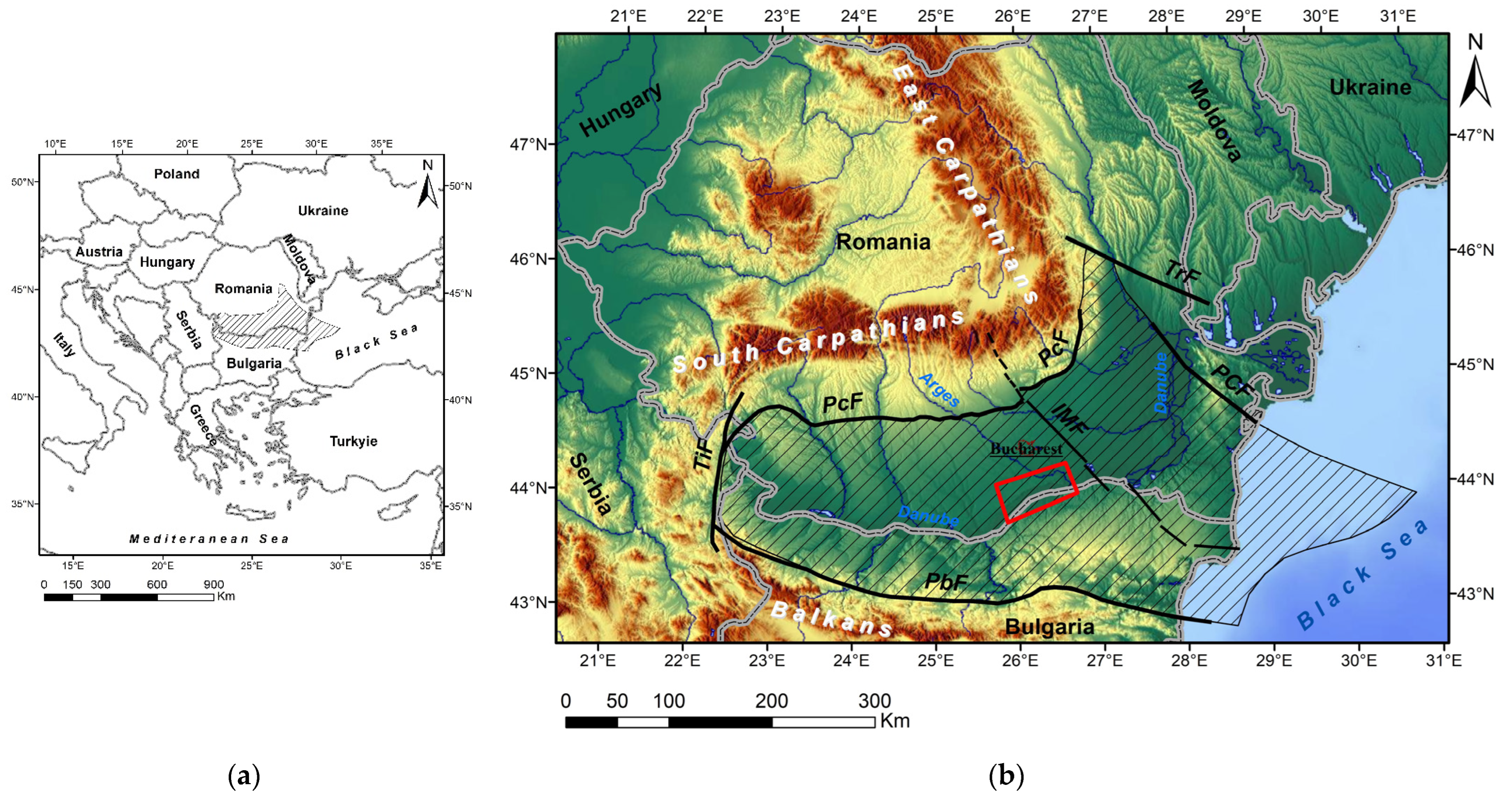
:1. Introduction

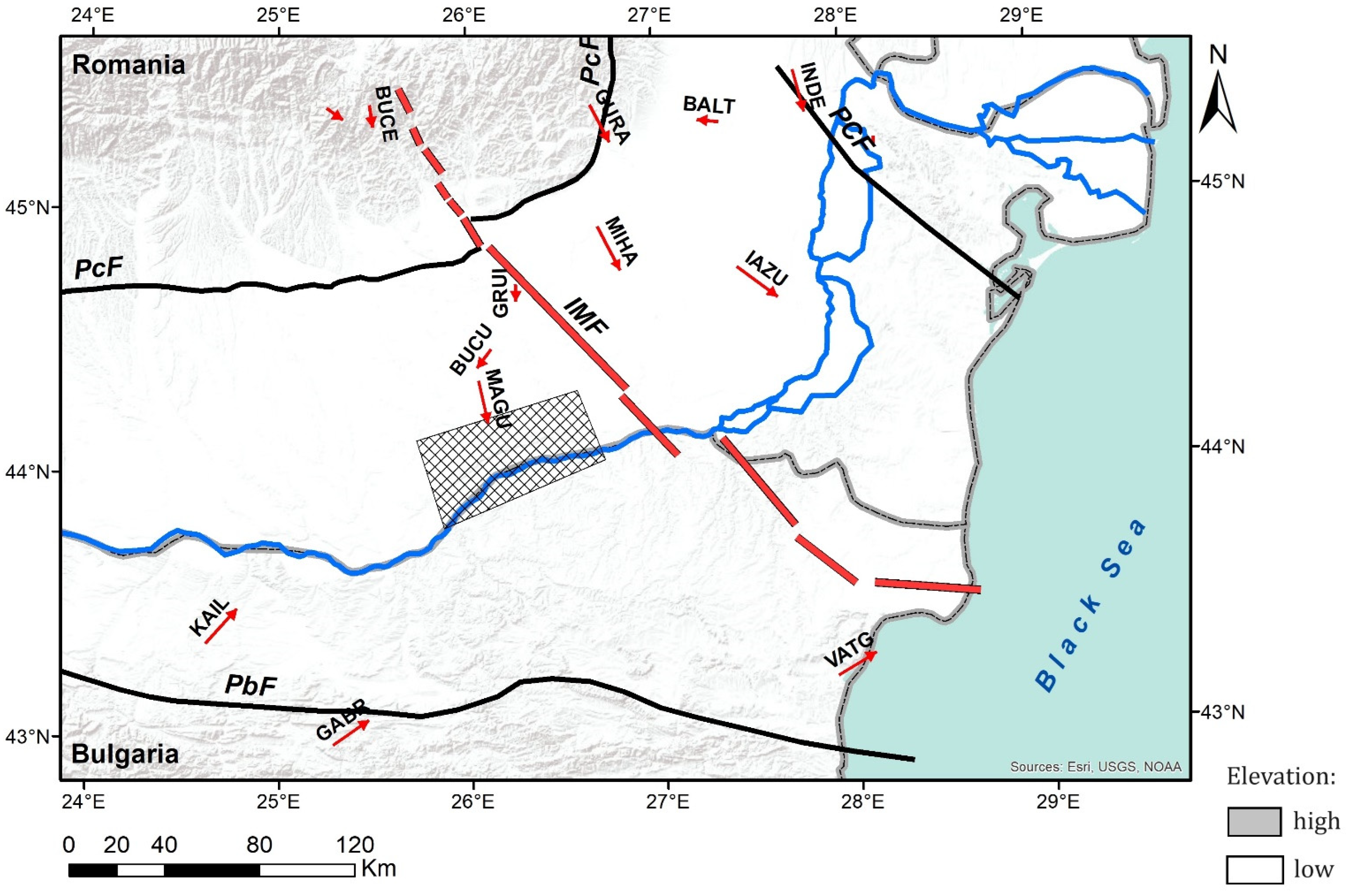
- a NW–SE (mainly) strike-slip fault system, relatively transverse to the East Carpathians Bend Zone, ranging from Palaeozoic to Cretaceous;
- an east–west normal fault system, parallel to the Carpathian and Balkan orogens;
- a NE–SW fault system, parallel to the East Carpathians Bend zone—younger (considered by Săndulescu [1] to have been generated and, in part, reactivated during Neogene), with normal and strike-slip faults;
- a N–S fault system.

2. Data and Methods
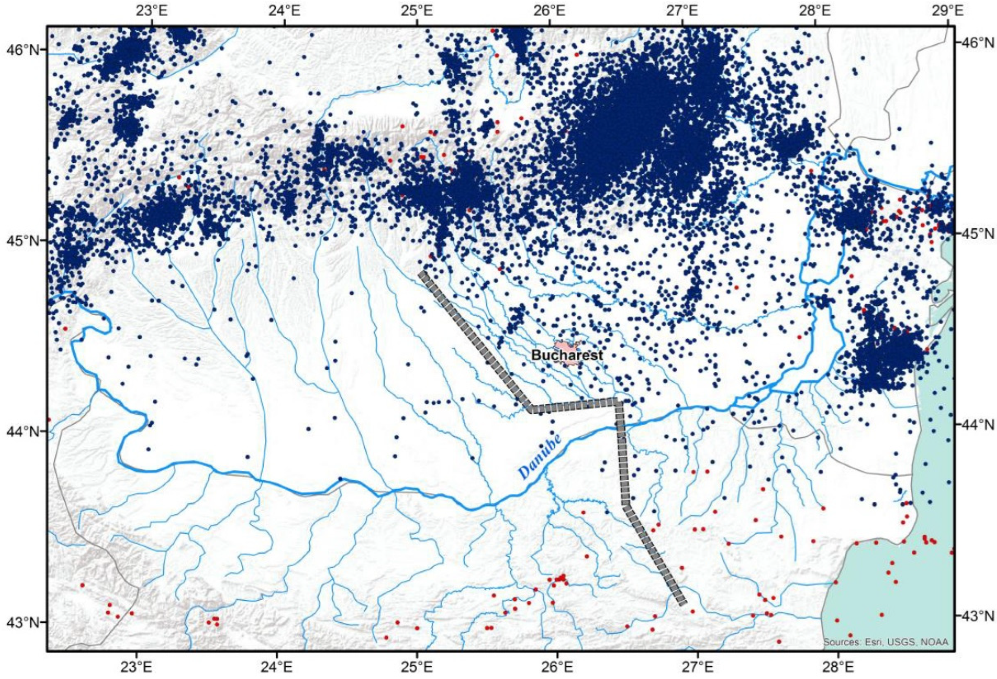
- For Romania and the Romanian Black Sea shore, the National Institute for Earth’s Physics ROMPLUS Earthquake Catalogue [64] was used. We used the earthquake recordings from the time interval 984–2022.
- For Bulgaria and the Bulgarian Black Sea shore, an updated earthquake catalogue from Bulgaria was not available. The BIGSEES Selection of Earthquakes Catalogue [65] was considered the best option for the integrated study of the Romanian and Bulgarian parts of the Moesian Platform, as the BIGSEES Selection of Earthquakes covers the territory of Romania, plus ca. 100 km of neighbouring areas, which includes the Moesian Platform in northern Bulgaria. The BIGSEES Selection of Earthquakes Catalogue was compiled by the National Institute for Earth’s Physics (NIEP) within their BIGSEES project and includes recordings for the time interval 984–August 2016, moment magnitude (Mw) ≥ 2.8 earthquakes.
3. Results
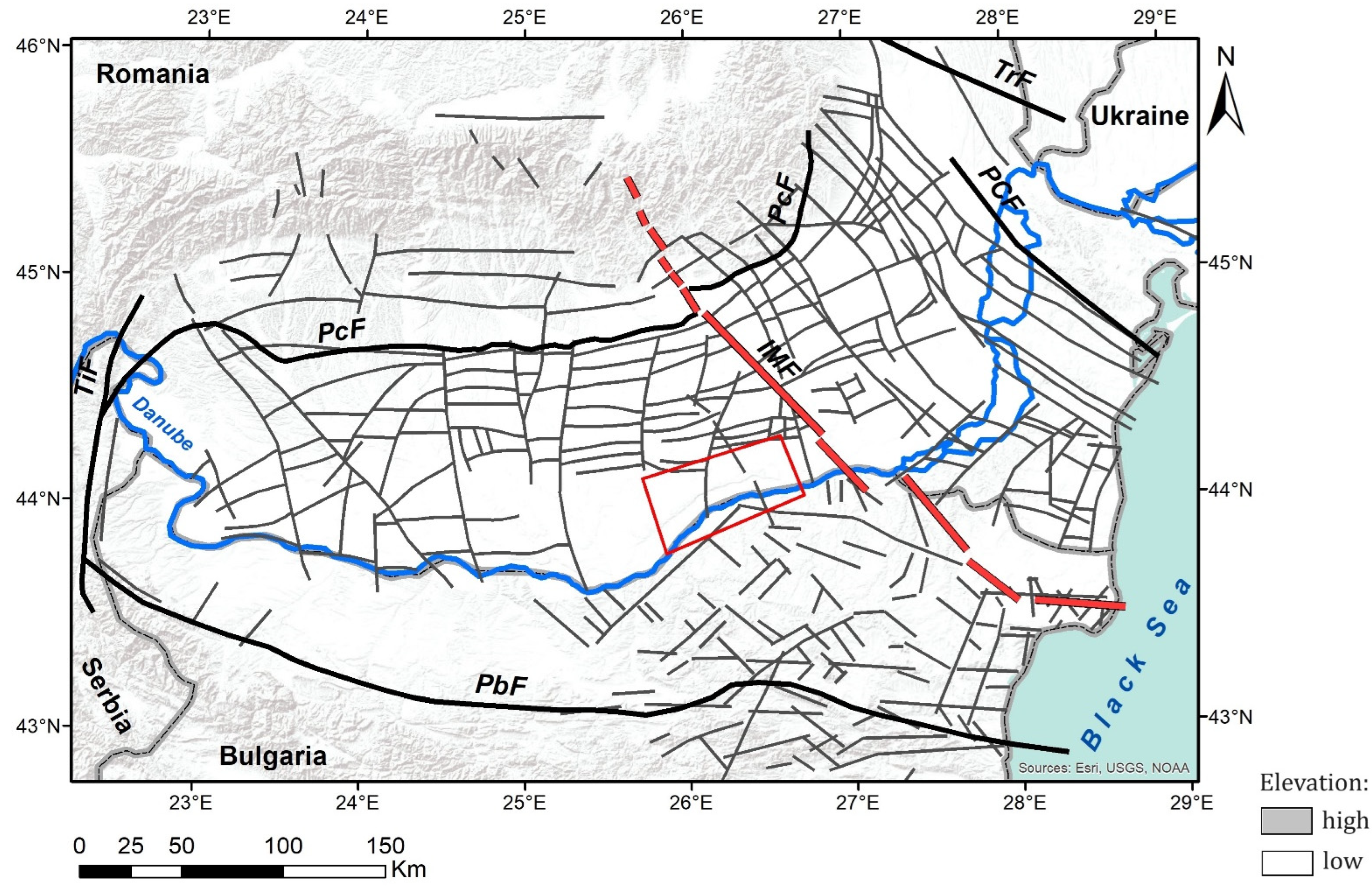
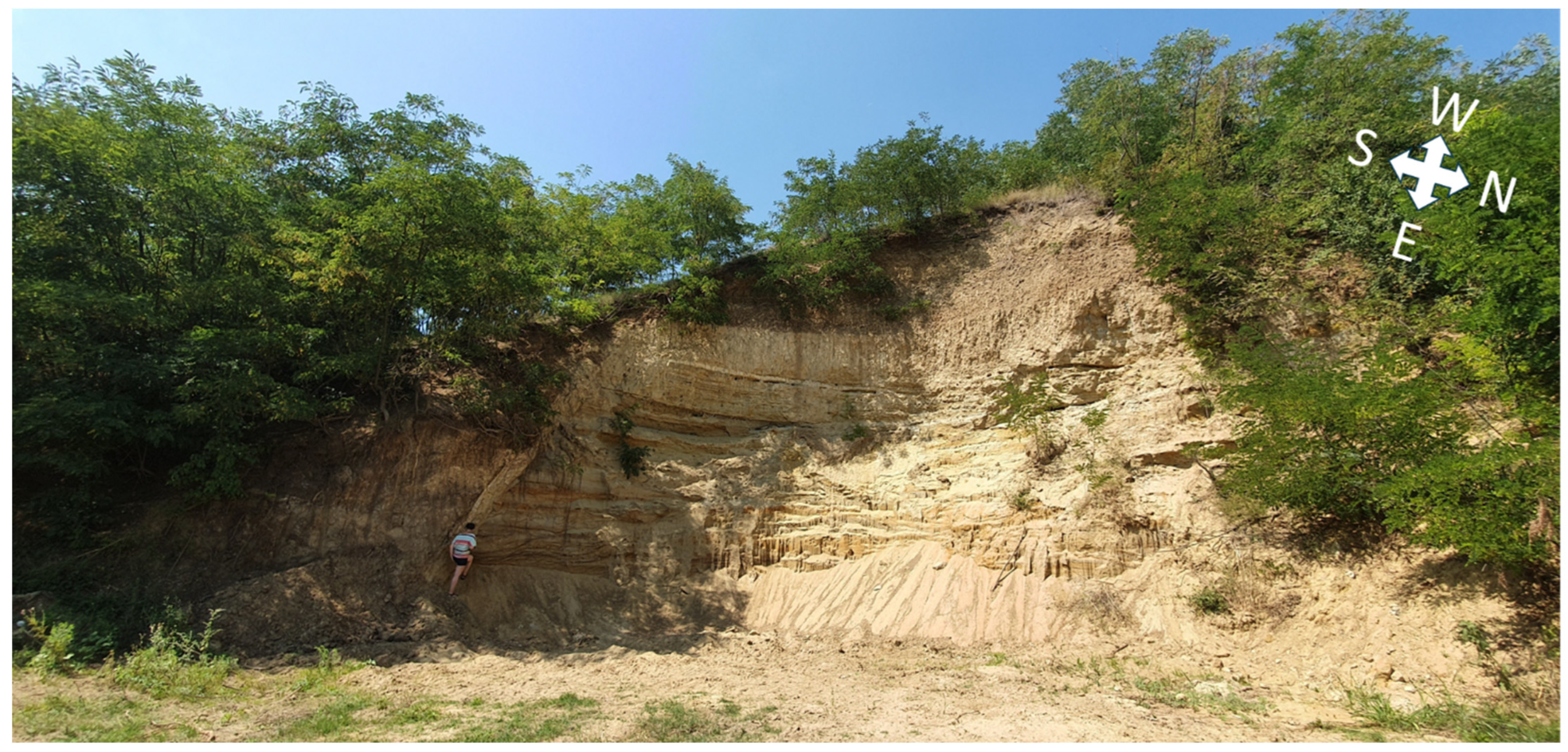
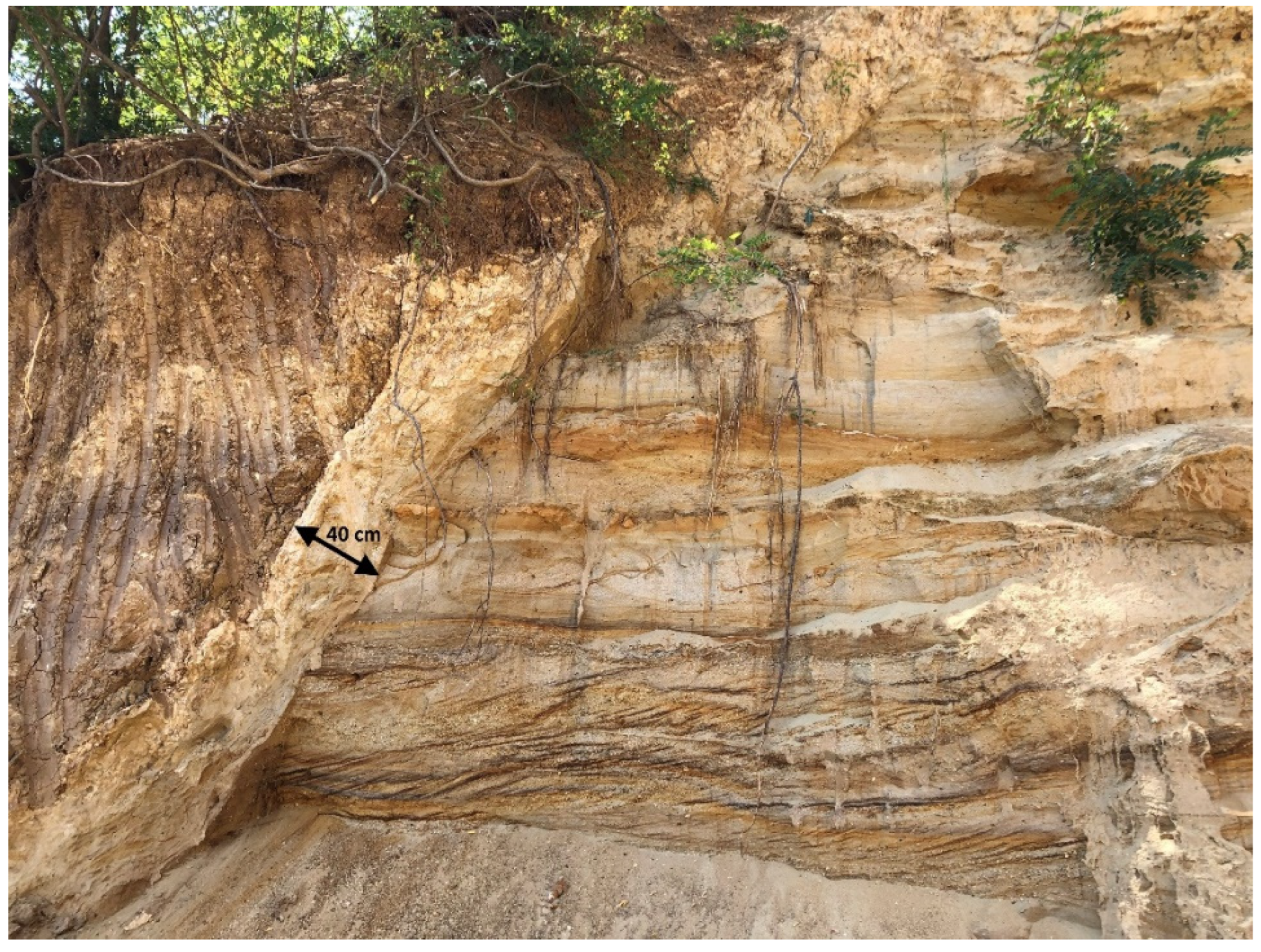
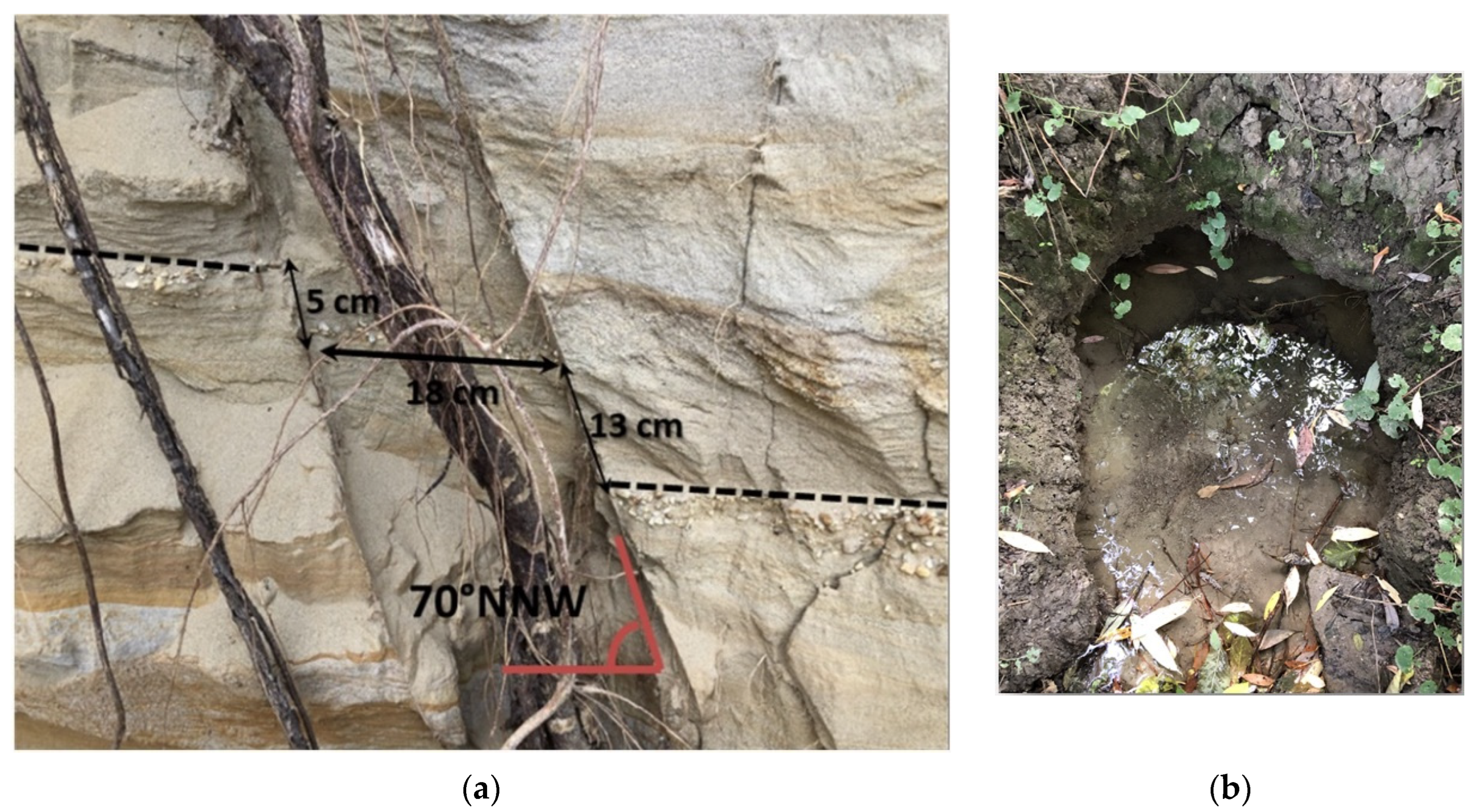
3.1. Geological Observations
3.2. Geomorphological Observations
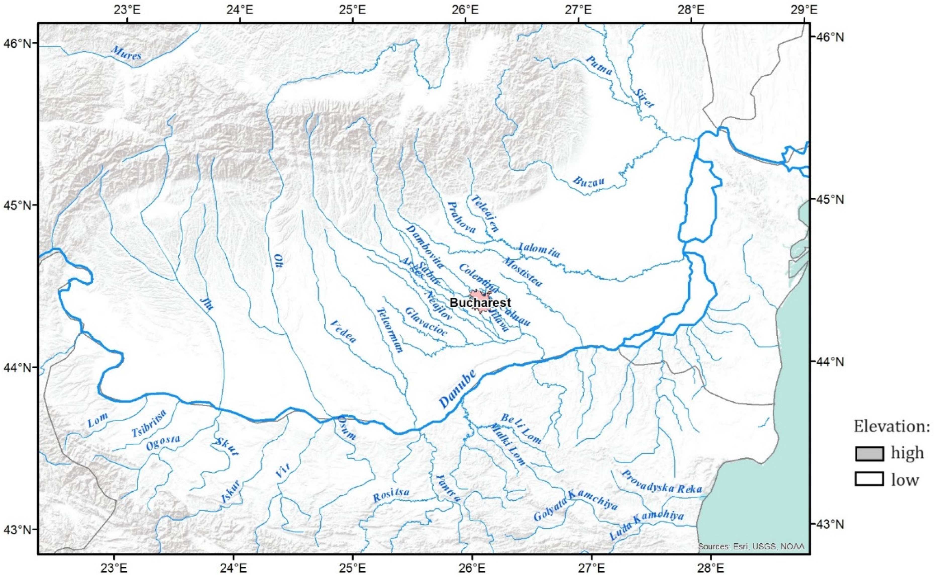
- The Danube River flows from W to E through the Moesian Platform, delineating the northern (Romanian) and southern (Bulgarian) parts of the Moesian Platform, as it serves as a natural boundary between Romania and Bulgaria. It acts as an axis between the main rivers of the Romanian Moesian Platform, which are trending NW–SE, and the main rivers of the Bulgarian Moesian Platform, which are trending SW–NE, towards the Romanian rivers’ points of drainage.
- The main rivers draining within the Romanian Moesian Platform run nearly perpendicular to the Carpathians, trending NW–SE in Western Moesia until they flow into the Danube River, while in Eastern Moesia the rivers turn eastward until they flow into the Danube River, and some of them turn north-eastward until they flow into the Siret River.
- Fielitz and Seghedi [95] observed that the river network in the Romanian Moesian Platform changed from predominantly braided river channels in Western Moesia to predominantly and often extremely meandering river channels in Eastern Moesia, due to a higher river gradient in Western Moesia vs. a lower river gradient and a finer-grained bedload in the Eastern Moesia, as well as due to the subsidence affecting the Focşani Depression.
- Mostiştea is the easternmost river in the Moesian Platform flowing in the NW–SE direction. Overall, its right (western) bank is slightly elevated than the eastern one. However, in the Mostiştea lake area, the right (western) bank shows a more than 20 m steep slope of leoss-paleosoil sequences [96,97], overlying fluvio-lacustrine sediments, which contain mammal fossils of Pleistocene age [96].
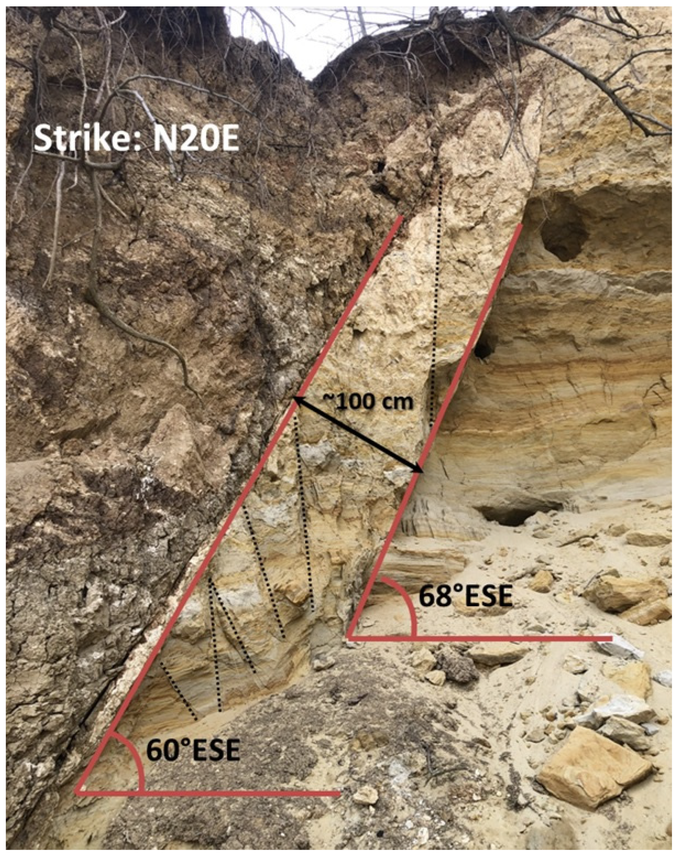
- On the western bank of the Mostiştea lake (Sultana locality, Călăraşi county), local NE–SW-trending faults affecting the outcropping sedimentary layers have been observed during field works in 2020 [11].
- Western Moesia’s river network is denser than Eastern Moesia’s river network.
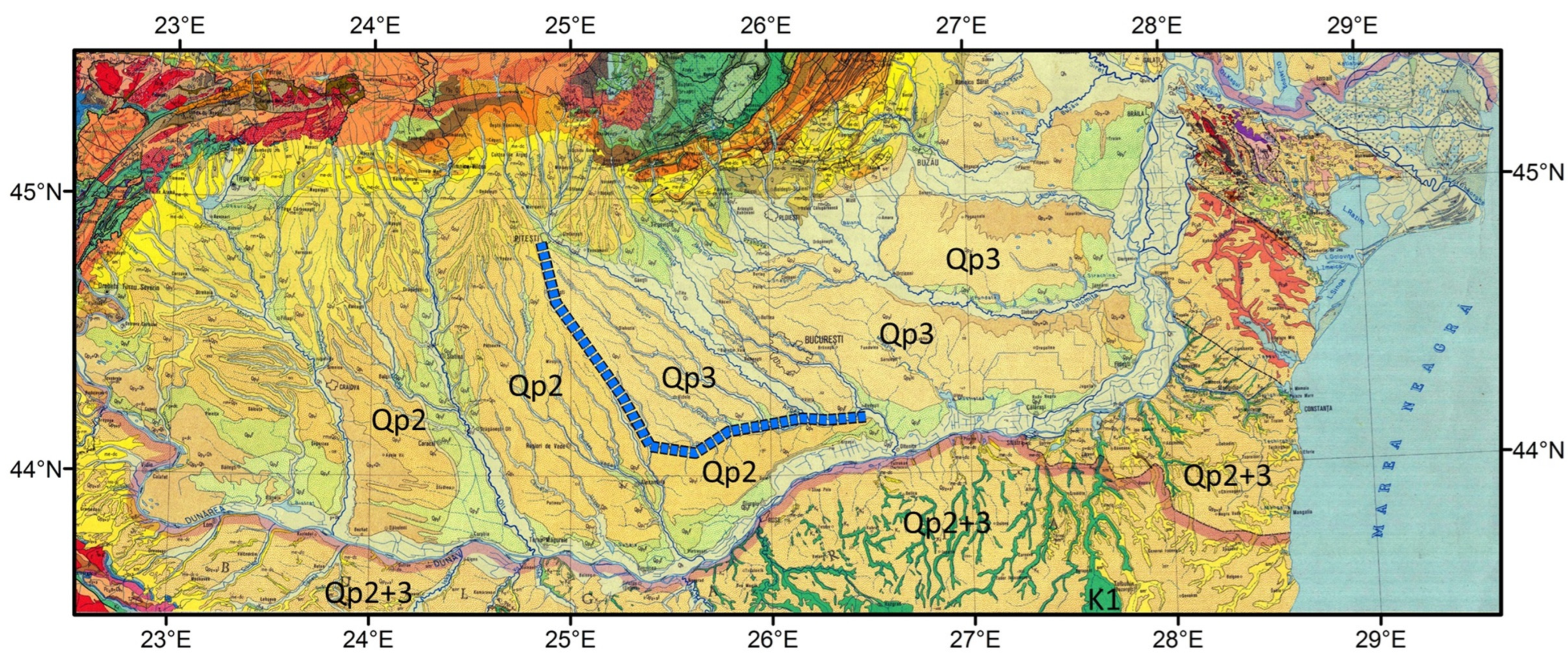
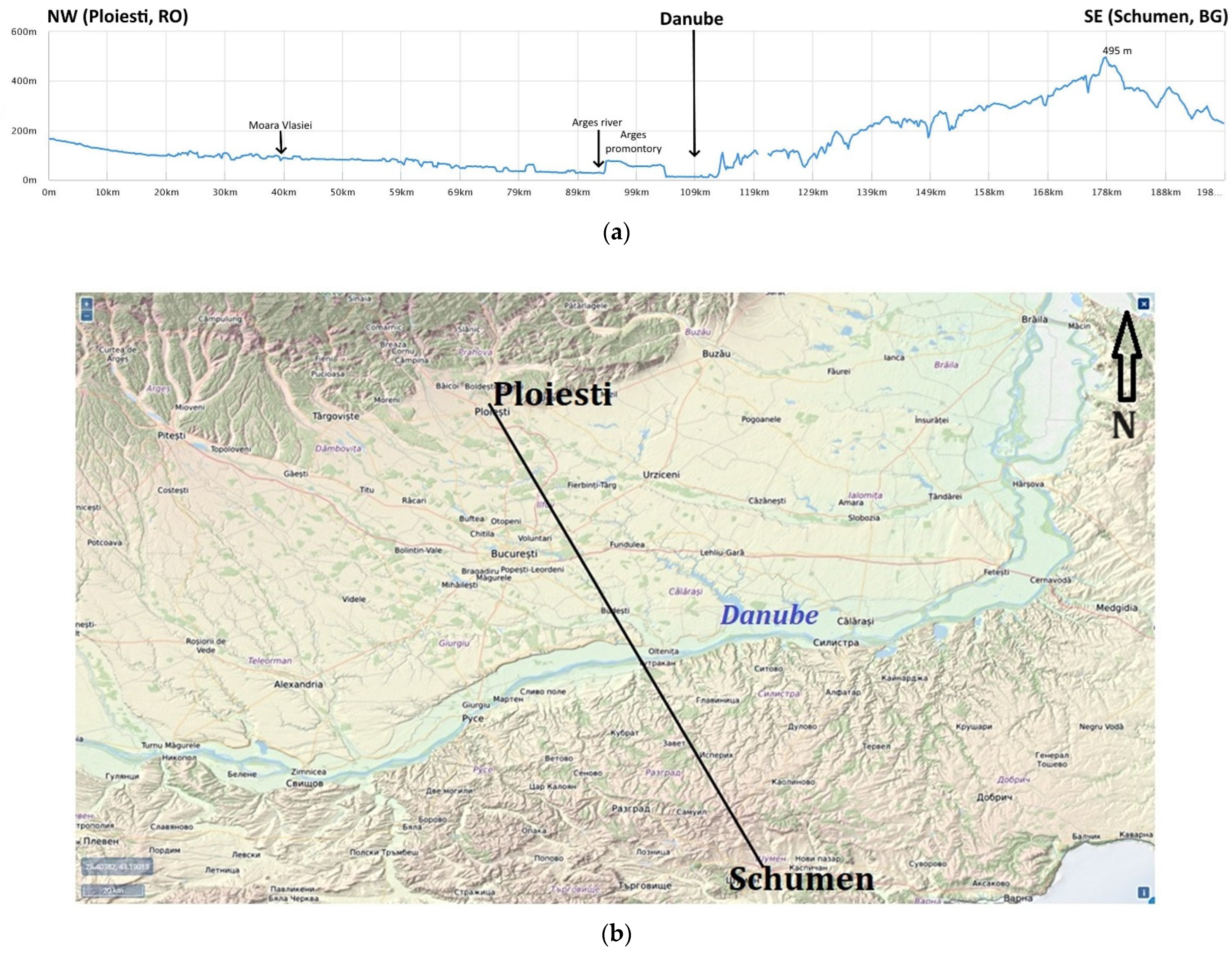
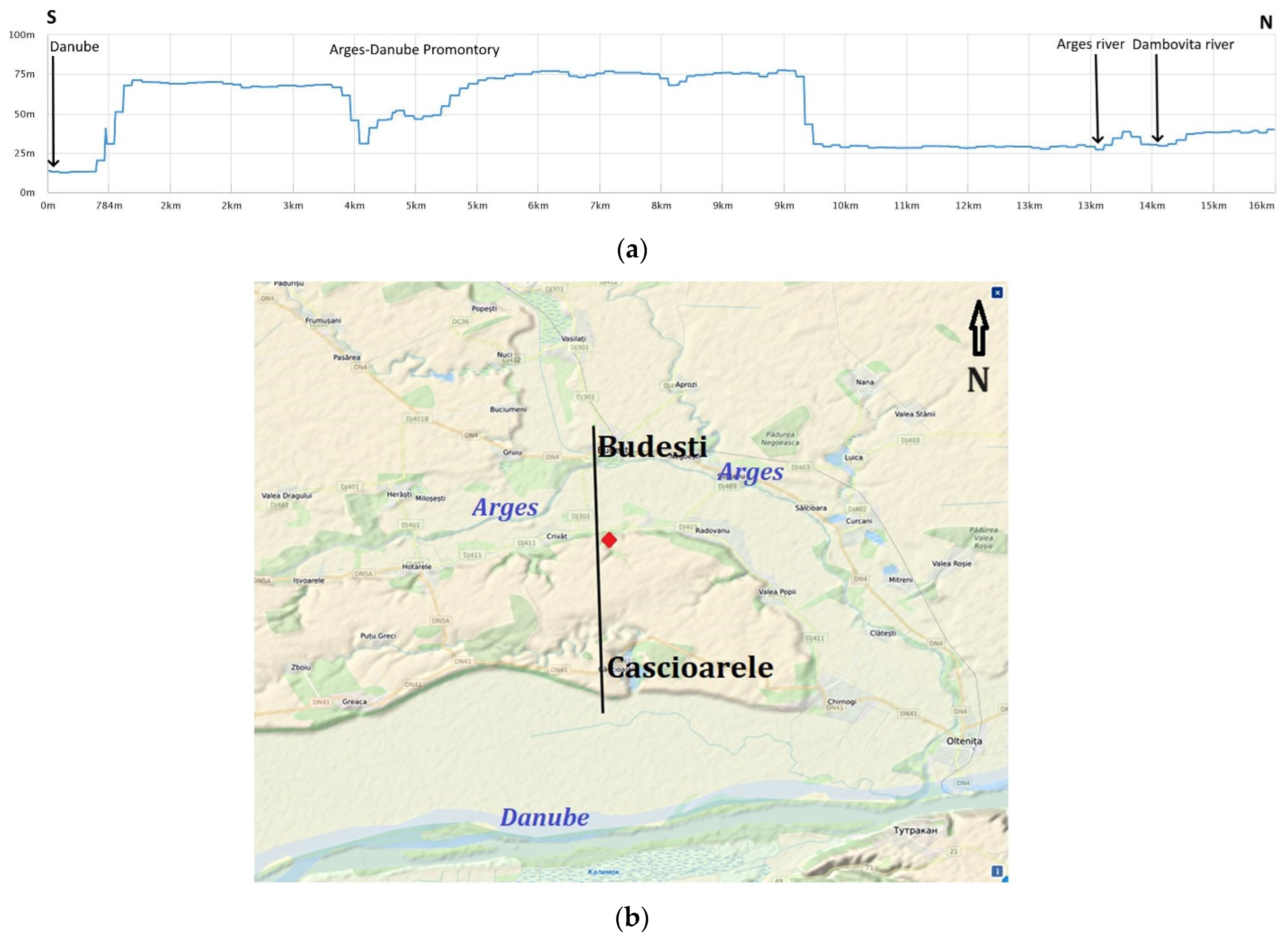
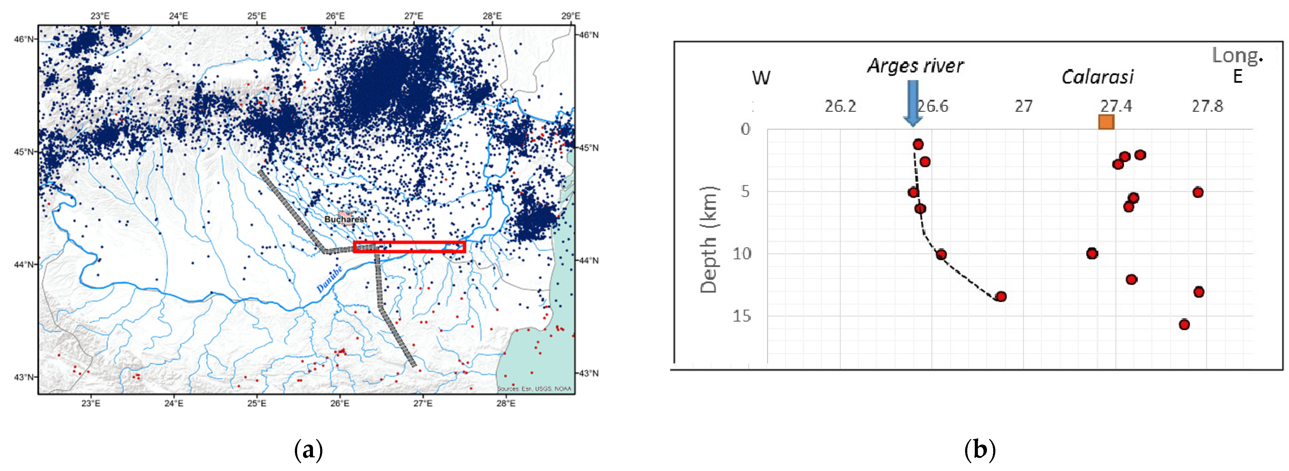
- A transition zone from Western Moesia’s river drainage to Eastern Moesia’s river drainage, between the Teleorman and Mostiştea rivers, refers to the Argeş drainage basin. The Argeş River and all its tributaries within the Moesian Platform have NW–SE courses, which suddenly end south of Bucharest on a sharp W–E change of flow direction. The morphology of the W–E Argeş River valley displays a southern steep bank, ca 15 m in height, which separates a southern uplifted, hilly geomorphology compartment (i.e., the Argeş Promontory) from a northern, flat geomorphology compartment. The observed W–E uplifted Argeş Promontory acts as a barrier for the Argeş River and its tributaries and displaces the Argeş River course eastward by ca. 25 km. Right before the point where the Dâmboviţa River flows into the Argeş River, a ca. 3 km north-eastward displacement of the Argeş River is also to be observed. Meandering palaeo-valleys of the Argeş River are still to be observed in this area on remote sensing imagery data, including Google Earth. After the point where the Dâmboviţa river flows into the Argeş River and the Argeş Promontory ends, the Argeş River returns to its NW–SE course and flows into the Danube River.
3.3. Seismicity within the Argeş Promontory Area
3.4. Satellite Geodetic Data Analysis
4. Discussion
5. Conclusions
Author Contributions
Funding
Data Availability Statement
Conflicts of Interest
References
- Săndulescu, M. Geotectonica României; Editura Tehnică: Bucharest, Romania, 1984; p. 336. [Google Scholar]
- Visarion, M.; Săndulescu, M.; Stănică, D.; Veliciu, S. Contributions à la connaissance de la structure profonde de la plateforme Moésienne en Roumanie. Stud. Teh. Econ.-Geofiz. 1988, 15, 68–92. [Google Scholar]
- Săndulescu, M. The Rumanian Foreland. In Tectonics of the Carpathian Balkan Regions, Platforms of the Foreland; Geological Institute of Dionyz Stur: Bratislava, Slovakia, 1974; pp. 446–449. [Google Scholar]
- Paraschiv, D. Platforma Moesică și Zăcămintele ei de Hidrocarburi; Editura Academiei Române: Bucharest, Romania, 1979; p. 196. [Google Scholar]
- Tărăpoancă, M.; Bertotti, G.; Maţenco, L.; Dinu, C.; Cloetingh, S.A.P.L. Architecture of the Focşani Depression: A 13 km deep basin in the Carpathians bend zone (Romania). Tectonics 2003, 22, 1074. [Google Scholar] [CrossRef]
- Seghedi, A.; Berza, T.; Iancu, V.; Mărunţiu, M.; Oaie, G. Neoproterozoic terranes in the Moesian basement and in the Alpine Danubian nappes of the South Carpathians. Geol. Belg. 2005, 84, 4–19. [Google Scholar]
- Seghedi, A.; Vaida, M.; Iordan, M.; Verniers, J. Paleozoic evolution of the Romanian part of the Moesian Platform: An overview. Geol. Belg. 2005, 84, 99–120. [Google Scholar]
- Boncev, E. Moesian Platform. In Tectonics of the Carpathian Balkan Regions, Platforms of the Foreland; Geological Institute of Dionyz Stur: Bratislava, Slovakia, 1974; pp. 449–453. [Google Scholar]
- Zagorchev, I. Geomorphological zonation of Bulgaria. Principles and state of the art. Compt. Rend. Acad. Bul. Sci. 2009, 62, 981–992. [Google Scholar]
- Tari, G.; Dicea, O.; Faulkerson, J.; Georgiev, G.; Popov, S.; Ştefănescu, M.; Weir, G. Cimmerian and Alpine stratigraphy and structural evolution of the Moesian Platform. In Regional and Petroleum Geology of the Black Sea and Surrounding Regions; Robinson, A.G., Ed.; American Association of Petroleum Geologists: Tulsa, OK, USA, 1997; Volume 68, pp. 63–90. [Google Scholar]
- Stanciu, I.M. Intramoesian Fault: Geophysical Detection and Regional Active (Neo)Tectonics and Geodynamics. Ph.D. Thesis, Doctoral School of Geology, Faculty of Geology and Geophysics, University of Bucharest, Bucharest, Romania, 2020. [Google Scholar]
- Relief Map. Available online: https://maps-for-free.com/ (accessed on 5 January 2021).
- Burchfiel, B.C. Geology of Romania; Geological Society of America: Boulder, CO, USA, 1976; Volume 158, pp. 1–82. [Google Scholar] [CrossRef]
- Ziegler, P.A. Geodynamic model for the Palaeozoic crustal consolidation of W. and C. Europe. Tectonophysics 1986, 126, 303–328. [Google Scholar] [CrossRef]
- Matte, P.; Maluski, H.; Railich, P.; Franke, W. Terrane boundaries in the Bohemian Massif: Result of large scale Variscan shearing. Tectonophysics 1990, 177, 151–170. [Google Scholar] [CrossRef]
- Kalvoda, J. Upper Devonian-Lower Carboniferous foraminiferal palaeobiogeography and Perigondwana terranes at the Baltica-Gondwana interface. Geol. Carpathica 2001, 52, 205–215. [Google Scholar]
- Yanev, S. Gondwana Paleozoic terranes in the Alpine collage system of the Balkans. Himal. Geol. 1993, 4, 257–270. [Google Scholar]
- Yanev, S. Paleozoic Migration of Terranes from the Basement of the Eastern Part of the Balkan Peninsula from Peri-Gondwana to Laurussia; Special Publication 3; Turkish Association Petroleum Geologists: Ankara, Turkey, 1997; pp. 89–100. [Google Scholar]
- Yanev, S. Palaeozoic terranes of the Balkan Peninsula in the framework of Pangea assembly. Palaeogeogr. Palaeoclimatol. Palaeoecol. 2000, 161, 151–177. [Google Scholar] [CrossRef]
- Yanev, S.; Boncheva, I. Contribution to the Paleozoic evolution of the recent Moesian platform. Geol. Balc. 1995, 25, 3–23. [Google Scholar] [CrossRef]
- Yanev, S.; Boncheva, I. New Data on the Collision between Peri-Gondwana Moesian Terrane and Dobrudja Periphery of Paleo Europe; Special Publication 3; Turkish Association Petroleum Geologists: Ankara, Turkey, 1997; pp. 118–132. [Google Scholar]
- von Raumer, J.V.; Stampfli, G.M.; Borel, G.; Bussy, F. Organization of pre-Variscan basement areas at the north-Gondwanan margin. Int. J. Earth Sci. 2002, 91, 35–52. [Google Scholar] [CrossRef]
- von Raumer, J.V.; Stampfli, G.M.; Bussy, F. Gondwana-derived microcontinents—The constituents of the Variscan and Alpine collisional orogens. Tectonophysics 2003, 365, 7–22. [Google Scholar] [CrossRef]
- Deroin, J.P.; Bonin, B. Late Variscan tectonomagmatic activity in Western Europe and surrounding areas: The Mid-Permian episode. Ital. J. Geosci. 2003, 2, 169–184. [Google Scholar]
- Żelaźniewicz, A.; Marheine, D.; Oberc-Dziedzic, T. A Late Tournaisian synmetamorphic folding and thrusting event in the eastern Variscan foreland: 40 Ar/39 Ar evidence from the phyllites of the Wolsztyn–Leszno High, western Poland. Int. J. Earth Sci. 2003, 92, 185–194. Available online: https://link.springer.com/content/pdf/10.1007%2Fs00531-002-0306-7.pdf (accessed on 1 May 2020). [CrossRef]
- Żelaźniewicz, A.; Oberc-Dziedzic, T.; Fanning, C.M. The Trans-European Suture Zone: Origin and tectonomagmatic events in late Variscan times. In Proceedings of the 35th International Geological Congress, Cape Town, South Africa, 27 August–4 September 2016; p. 2481. Available online: https://www.americangeosciences.org/sites/default/files/igc/2481.pdf (accessed on 1 May 2020).
- Yanev, S.; Lakova, I.; Boncheva, I.; Sachanski, V. The Moesian and Balkan terranes in Bulgaria: Palaeozoic basin development, palaeogeopgraphy and tectonic evolution. Geol. Belg. 2005, 84, 185–192. [Google Scholar]
- Oczlon, M.S.; Seghedi, A.; Carrigan, C.W. Avalonian and Baltican terranes in the Moesian Platform (southern Europe, Romania, and Bulgaria) in the context of Caledonian terranes along the southwestern margin of the East European craton. In The Evolution of the Rheic Ocean: From Avalonian-Cadomian Active Margin to Alleghenian-Variscan Collision; Special Paper 423; Linnemann, U., Nance, R.D., Kraft, P., Zulauf, G., Eds.; Geological Society of America: Boulder, CO, USA, 2007; pp. 375–400. [Google Scholar] [CrossRef]
- Săndulescu, M. The Geotectonic framework of a peculiar seismogenic area—The Vrancea seismic zone (Romanian Carpathians). Proc. Rom. Acad. Ser. B 2009, 2–3, 151–157. Available online: https://acad.ro/sectii2002/proceedingsChemistry/doc2009-23/art10Sandulescu.pdf (accessed on 10 September 2019).
- Artemieva, I.M.; Thybo, H. EUNAseis: A seismic model for Moho and crustal structure in Europe, Greenland, and the North Atlantic region. Tectonophysics 2013, 609, 97–153. [Google Scholar] [CrossRef]
- Winchester, J.A.; Pharaoh, T.C.; Verniers, J. Palaeozoic amalgamation of Central Europe: An introduction and synthesis of new results from recent geological and geophysical investigations. In Palaeozoic Amalgamation of Central Europe; Special Publications; Winchester, J.A., Pharaoh, T.C., Verniers, J., Eds.; Geological Society: London, UK, 2002; Volume 201, pp. 1–18. [Google Scholar]
- Stille, H. Der tektonische Werdegang der Karpaten. Beih. Z. Geol. Jahrb. 1953, 8, 1–239. [Google Scholar]
- Berza, T.; Constantinescu, E.; Vlad, Ş.N. Upper Cretaceous magmatic series and associated mineralisation in the Carpathian-Balkan Orogen. Res. Geol. 1998, 48, 291–306. [Google Scholar] [CrossRef]
- Ratschbacher, L.; Linzer, H.G.; Moser, F.; Strusievicz, R.-O.; Bedelean, H.; Har, N.; Mogoş, P.A. Cretaceous to Miocene thrusting and wrenching along the central South Carpathians due to a corner effect during collision and orocline formation. Tectonics 1993, 12, 855–873. [Google Scholar] [CrossRef]
- Linzer, H.G. Kinematics of retreating subduction along the Carpathian arc, Romania. Geology 1996, 24, 167–170. [Google Scholar] [CrossRef]
- Hippolyte, J.C. Geodynamics of Dobrogea (Romania): New constraints on the evolution of the Tornquist-Tesseire Line, the Black Sea and the Carpathians. Tectonophysics 2002, 357, 33–53. [Google Scholar] [CrossRef]
- Rădulescu, D.P.; Cornea, I.; Săndulescu, M.; Constantinescu, P.; Rădulescu, F.; Pompilian, A. Structure de la croûte terrestre en Roumanie—Essai d’interprétation sismiques profonds. An. Inst. Geol. Geof. 1976, 50, 5–36. [Google Scholar]
- Rădulescu, F. Seismic models of the crustal structure in Romania. Rev. Roum. Géol. Géophys. Géogr. Sér. Géophys. 1988, 32, 13–17. [Google Scholar]
- Răileanu, V.; Diaconescu, C.; Rădulescu, F. Characteristics of Romanian lithosphere from deep seismic reflection profiling. Tectonophysics 1994, 239, 165–185. [Google Scholar] [CrossRef]
- Hauser, F.; Răileanu, V.; Fielitz, W.; Bălă, A.; Prodehl, C.; Polonic, G.; Schulze, A. VRANCEA99—The crustal structure beneath the southeastern Carpathians and the Moesian Platform from a seismic refraction profile in Romania. Tectonophysics 2001, 340, 233–256. [Google Scholar] [CrossRef]
- Hauser, F.; Răileanu, V.; Fielitz, W.; Dinu, C.; Landes, M.; Bălă, A.; Prodehl, C. Seismic crustal structure between the Transylvanian Basin and the Black Sea, Romania. Tectonophysics 2007, 430, 1–25. [Google Scholar] [CrossRef]
- Polonic, G. Structure of the crystalline basement in Romania. Rev. Roum. Geophys. 1996, 40, 57–70. [Google Scholar]
- Paraschiv, D. Geologia Zăcămintelor de Hidrocarburi din România; Institutul de Geologie și Geofizică: Bucharest, Romania, 1975; p. 327. [Google Scholar]
- Burcea, C.; Cornea, I.; Ţugui, G.; Ionescu, E.; Trîmbiţaş, M.; Georgescu, S.; Leafu, I.; Tomescu, L., II; Braşoveanu, A.; Chişcan, M.; et al. Contribuţii seismice la crearea unei imagini tectonice asupra marginii nordice a Platformei Moesice între Olt şi Buzău. St. Cerc. Geol. Geofiz. Geogr. Ser. Geofiz. 1965, 3, 129–139. [Google Scholar]
- Burcea, C.; Cornea, I.; Ţugui, G.; Tomescu, L., II; Ionescu, E.; Trîmbiţaş, M.; Leafu, I.; Dumitrescu, V.; Braşoveanu, A.; Sipoş, V.; et al. Contribuţii ale prospecţiunii seismice la crearea unei imagini tectonice în zona centrală a Platformei Moesice. St. Cerc. Geol. Geofiz. Geogr. Ser. Geofiz. 1966, 4, 347–353. [Google Scholar]
- Dumitrescu, I.; Săndulescu, M. Harta tectonică a României, 1:1,000,000. In Atlasul Geologic; Foaia Nr. 6; Geological Institute of Romania: Bucharest, Romania, 1970. [Google Scholar]
- Cornea, I.; Polonic, G. Date privind seismicitatea şi seismotectonica părţii de est a Platformei Moesice. Stud. Cercet. Geol. Geofiz. Geogr. Geofiz. 1979, 17, 167–176. [Google Scholar]
- Săndulescu, M.; Visarion, M. La structure des plate-formes situees dans l’avant-pays et au-dessous des nappes du flysch des Carpathes Orientales. St. Teh. Econ. Geofiz. 1988, 15, 62–67. [Google Scholar]
- Dicea, O. The structure and hydrocarbon geology of the Romanian East Carpathians border from seismic data. Pet. Geosci. 1995, 1, 135–143. [Google Scholar] [CrossRef]
- Matova, M. Recent geological activity along the northeastern Bulgarian Black Sea coast. Geol. Quaterly 2000, 44, 355–361. Available online: https://gq.pgi.gov.pl/article/viewFile/8109/pdf_215 (accessed on 15 September 2016).
- Dinu, C.; Wong, H.K.; Ţămbrea, D.; Maţenco, L. Stratigraphic and structural characteristics of the Romanian Black Sea shelf. Tectonophysics 2005, 410, 417–435. [Google Scholar] [CrossRef]
- Shanov, S.; Boycova, A.; Mitev, A. Intramoesian Fault on Bulgarian territory: Available geophysical data. In Proceedings of the 4th Congress of the Balkan Geophysical Society, Bucharest, Romania, 9 October 2005; Volume 8, pp. 56–59. [Google Scholar] [CrossRef]
- Săndulescu, M.; Visarion, M. Crustal structure and evolution of the Carpathian-Western Black Sea areas. First Break 2000, 18, 103–108. [Google Scholar] [CrossRef]
- Visarion, M.; Beşuţiu, L. Transcrustal faults on the Romanian territory. St. Cerc. Geofiz. 2001, 39, 15–33. [Google Scholar]
- Ioane, D.; Diaconescu, M.; Chitea, F.; Gârbacea, G. Active Fault Systems and Their Significance for Urban Planning in Bucharest, Romania. In Earthquake Hazard Impact and Urban Planning; Boştenaru, D., Armaş, I., Goretti, A., Eds.; Springer: Berlin/Heidelberg, Germany, 2014; pp. 15–45. [Google Scholar]
- Ioane, D.; Diaconescu, M.; Chitea, F.; Caragea, I. Active Fault Systems as Interpreted on Gravity and Seismicity Data in Bucharest-Vrancea Area. In Proceedings of the GEO 2014 Symposium, Bucharest, Romania, 26 April 2014. [Google Scholar]
- Stanciu, I.M.; Ioane, D. Regional seismicity in the Moesian Platform and the Intramoesian Fault. Geo-Eco-Marina 2017, 23, 263–271. [Google Scholar]
- Stanciu, I.M.; Ioane, D. Regional active faults as interpreted on crustal seismicity, gravity and magnetic data across the Moesian Platform and the North Dobrogean Orogen. In Proceedings of the 18th International Multidisciplinary Scientific GeoConference on Earth & Geosciences SGEM2018, Albena Resort, Bulgaria, 30 June–9 July 2018; Volume 18, pp. 939–946. [Google Scholar]
- Stanciu, I.M.; Ioane, D. Seismicity associated to the Intramoesian Fault: Inferences from regional tectonics and geodynamics. In Proceedings of the 19th International Multidisciplinary Scientific GeoConference on Earth & Geosciences SGEM2019, Albena, Bulgaria, 28 June–7 July 2019; Volmue 19, pp. 923–930. [Google Scholar] [CrossRef]
- Stanciu, I.; Ioane, D. Active fault systems in the Shabla region (Bulgaria) as interpreted on geophysical and seismicity data. Rev. Roum. Geophys./Rom. Geophys. J. 2021, 63–64, 3–21. [Google Scholar] [CrossRef]
- Stanciu, I.; Ioane, D. The Moesian Platform: Structural and tectonic features interpreted on regional gravity and magnetic data. Geo-Eco-Marina 2021, 27, 183–195. [Google Scholar] [CrossRef]
- Ioane, D.; Caragea, I. Western Boundary of East European Platform in Romania as Interpreted on Gravity and Magnetic Data. In Proceedings of the 8th Congress of the Balkan Geophysical Society, Greece, Chania, 4–8 October 2015. [Google Scholar] [CrossRef]
- Stanciu, I.; Ioane, D. Outcrop-based analysis of a recently discovered fault offsetting Upper Pliocene-Quaternary sedimentary deposits in the Moesian Platform (Romania). In ILP–Geoscience 2022. Book of Abstracts; Chitea, F., Munteanu, I., Mațenco, L., Dinescu, R., Stanciu, I., Eds.; Editura Cetatea de Scaun: Târgoviște, Romania, 2022; ISBN 978-606-537-578-9. [Google Scholar]
- Popa, M.; Chircea, A.; Dinescu, R.; Neagoe, C.; Grecu, B.; Borleanu, F. Romanian Earthquake Catalogue (ROMPLUS 984-2022); Mendeley Data, V2; Institutul National de Cercetare-Dezvoltare pentru Fizica Pamantului: Ilfov County, Romania, 2022; Available online: https://doi.org/10.17632/tdfb4fgghy.2 (accessed on 30 January 2023).
- BIGSEES Selection of Earthquakes Catalogue. Available online: http://infp.infp.ro/bigsees/Results.html (accessed on 10 December 2019).
- EMSC Earthquake Catalogue. Available online: http://www.emsc-csem.org (accessed on 10 December 2019).
- ISC-GEM Global Instrumental Earthquake Catalogue. Available online: http://www.isc.ac.uk/iscgem/download.php (accessed on 10 December 2019).
- Grünthal, G.; Wahlström, R. The European-Mediterranean Earthquake Catalogue (EMEC) for the last millennium. J. Seismol. 2012, 16, 535–570. [Google Scholar] [CrossRef]
- Shebalin, N.V.; Leydecker, G.; Mokrushina, N.G.; Tatevossian, R.E.; Erteleva, O.O.; Vassiliev, V.Y. Earthquake Catalogue for Central and Southeastern Europe 342 BC—1990 AD; Report No. ETNU CT 93-0087; European Commission: Brussels, Belgium, 1998.
- Stucchi, M.; Rovida, A.; Gomez Capera, A.A.; Alexandre, P.; Camelbeeck, T.; Demircioglu, M.B.; Gasperini, P.; Kouskouna, V.; Musson, R.M.W.; Radulian, M.; et al. The SHARE European Earthquake Catalogue (SHEEC) 1000–1899. J. Seismol. 2013, 17, 523–544. [Google Scholar] [CrossRef]
- SHEEC Earthquake Catalogue 1900–2006. Available online: http://sheec-1900-2006.gfz-potsdam.de/ (accessed on 1 October 2017).
- USGS Earthquake Catalogue. Available online: https://earthquake.usgs.gov/earthquakes/search/ (accessed on 10 December 2019).
- Shebalin, N.V.; Karnik, V.; Hadzievski, D. UNDP/UNESCO Survey of the Seismicity of the Balkan Region—Catalogue of Earthquakes; Printing Office of the University Kiril and Metodij: Skopje, North Macedonia, 1974. [Google Scholar]
- Ciocârdel, R.; Esca, A. Essai de synthese des donnees, actuelles concertant les mouvements verticaux recents de l’ecorce terrestre en Roumanie. Rev. Roum. Geol. Geophys. Geogr. Ser. Geophys. 1966, 10, 5–32. [Google Scholar]
- Brandabur, T.; Ghenea, C.; Săndulescu, M.; Ştefănescu, M. Harta neotectonică a României, 1:1,000,000. In Atlasul Geologic; Foaia Nr. 7; Geological Institute of Romania: Bucharest, Romania, 1971. [Google Scholar]
- Visarion, M.; Săndulescu, M.; Drăgoescu, I.; Drăghici, M.; Cornea, I.; Popescu, M. Harta Mişcărilor Crustale Verticale Recente, 1:1,000,000; Geological Institute of Romania: Bucharest, Romania, 1977. [Google Scholar]
- Cornea, I.; Drăgoescu, I.; Popescu, M.; Visarion, M. Harta mişcărilor crustale verticale recente pe teritoriul R.S. România. St. Cerc. Geol. Geophys. Geogr. Geophys. 1979, 17, 3–20. [Google Scholar]
- Popescu, M.N.; Drăgoescu, I. New map of recent vertical crustal movements in Romania, 1:1,000,000. Rev. Roum. Geol. Geophys. Et Geogr. Ser. Geophys. 1986, 30, 3–10. [Google Scholar]
- Blewitt, G.; Lavallee, D.; Clarke, P.J.; Nurutdinov, K. A New Global Mode of Earth Deformation: Seasonal Cycle Detected. Science 2002, 294, 2342–2345. [Google Scholar] [CrossRef]
- van Dam, T.; Blewitt, G.; Heflin, M. Atmospheric pressure loading effects on Global Positioning System coordinate determinations. J. Geophys. Res. 1994, 99, 23939–23950. [Google Scholar] [CrossRef]
- Scherneck, H.G. A parametrized Solid Earth Tide Model and Ocean Tide Loading Effects for global geodetic baseline measurements. Geophys. J. Int. 1991, 106, 677–6941991. [Google Scholar] [CrossRef]
- Mangiarotti, S.; Cazenave, A.; Soudarin, L.; Cretaux, J.F. Annual vertical crustal motions predicted from surface mass redistribution and observed by space geodesy. J. Geophys. Res. 2001, 106, 4277–4291. [Google Scholar] [CrossRef]
- Miller, M.M.; Melbourne, T.; Johnson, D.J.; Sumner, W.Q. Periodic Slow Earthquakes from the Cascadia Subduction Zone. Science 2002, 295, 2423. [Google Scholar] [CrossRef] [PubMed]
- Alba, S.; Weldon, R.J.; Livelybrooks, D.; Schmidt, D.A. Cascadia ETS Events Seen in Tidal Records (1980–2011). Bul. Seis. Soc. Am. 2019, 109, 812–821. [Google Scholar] [CrossRef]
- Barlik, M.; Borza, T.; Busics, I.; Fejes, I.; Pachelski, W.; Rogowski, J.; Sledzinski, J.; Zielinski, J. Central Europe Regional Geodynamics Project. Rep. Geod. 1994, 2, 7–24. [Google Scholar]
- Fejes, I. Consortium for Central European GPS Geodynamic Reference Network (CEGRN Consortium). In The Adria Microplate: GPS Geodesy, Tectonics, and Hazards; Pinter, N., Grenerczy, G., Weber, J., Stein, S., Medak, D., Eds.; Springer: Dordrecht, The Netherlands, 2006; pp. 183–194. [Google Scholar]
- Caporali, A.; Aichhorn, C.; Becker, M.; Fejes, I.; Gerhatova, L.; Ghitau, D.; Grenerczy, G.; Hefty, J.; Krauss, S.; Medak, K.; et al. Geokinematics of Central Europe: New insights from the CERGOP-2/Environment Project. J. Geodyn. 2008, 45, 246–256. [Google Scholar] [CrossRef]
- Hefty, J. Work-Package 5 of the CERGOP-2/Environment: GPS data analysis and the definition of reference frames activity report April 2004–September 2004. Rep. Geod. 2004, 4, 23–34. [Google Scholar]
- Hefty, J. Work-Package 7 of the CERGOP-2/Environment: Geokinematical modelling and strain analysis activity report April 2004–September 2004. Rep. Geod. 2004, 4, 39–42. [Google Scholar]
- Săndulescu, M.; Krautner, H.; Borcoş, M.; Năstăseanu, S.; Patrulius, D.; Ştefănescu, M.; Ghenea, C.; Lupu, M.; Savu, H.; Bercia, I.; et al. Harta geologică a României, 1:1,000,000. In Atlasul Geologic; Foaia Nr. 1; Romanian Institute of Geology and Geophysics: Bucharest, Romania, 1978. [Google Scholar]
- Oncescu, N. Geologia României; Editura Tehnică: Bucharest, Romania, 1965; p. 534. [Google Scholar]
- EMODNET Bathymetry Data Portal. Available online: https://portal.emodnet-bathymetry.eu/ (accessed on 10 May 2020).
- Stanciu, I.M.; Ioane, D.; Seghedi, A. Chapter 1. Geographical setting, Geomorphological and Geotectonic framework of Bucharest City. In Bucharest—European Capital City with the Most Vulnerable Response to a Strong Earthquake; Ionescu, C., Radulian, M., Bălă, A., Eds.; Editura Cetatea de Scaun: Târgoviște, Romania, 2022; pp. 13–31. ISBN 978-606-537-601-4/ebook 978-606-537-602-1. [Google Scholar] [CrossRef]
- Keller, E.A.; Pinter, N. Active Tectonics: Earthquakes, Uplift, and Landscape, 2nd ed.; Prentice Hall: Upper Saddle River, NJ, USA, 2002; p. 362. [Google Scholar]
- Fielitz, W.; Seghedi, I. Late Miocene–Quaternary volcanism, tectonics and drainage system evolution in the East Carpathians, Romania. Tectonophysics 2005, 410, 111–136. [Google Scholar] [CrossRef]
- Panaiotu, C.G.; Panaiotu, E.C.; Grama, A.; Necula, C. Paleoclimatic record from a loess-paleosol profile in southeastern Romania. Phys. Chem. Earth Part A Solid Earth Geod. 2001, 26, 893–898. [Google Scholar] [CrossRef]
- Timar-Gabor, A.; Vasiliniuc, Ş.; Vandenberghe, D.; Cosma, C. Absolute Dating of Romanian Loess Using Luminescence Techniques: Palaeoclimatic Implications. 2009. Available online: https://www.researchgate.net/publication/292436437 (accessed on 15 September 2019).
- van der Hoeven, A.; Schmitt, G.; Dinter, G.; Mocanu, V.; Spakman, W. GPS probes the kinematics of the Vrancea seismogenic zone. EOS 2004, 85, 185–196. [Google Scholar] [CrossRef]
- van der Hoeven, A.; Mocanu, V.; Spakman, W.; Nutto, M.; Nuckelt, A.; Mațenco, L.; Munteanu, L.; Marcu, C.; Ambrosius, B. Observation of present-day tectonic motions in the Southeastern Carpathians: Results of the ISES/CRC-461 GPS measurements. Earth Planet. Sci. Lett. 2005, 239, 177–184. [Google Scholar] [CrossRef]
- Munteanu, L. Cinematica blocurilor tectonice din arealul vrâncean, utilizând tehnologie modernă satelitară de mare precizie. In Cercetări Privind Managementul Dezastrelor Generate de Cutremurele Românești; Mărmureanu, G., Ed.; Tehnopress: Iaşi, Romania, 2009; ISBN 973-702-7014-9. [Google Scholar]
- Milev, G.; Vassileva, K. Geodynamics of the Balkan Peninsula and Bulgaria. In Proceedings of the International Symposium on Strong Vrancea Earthquakes and Risk Mitigation, Bucharest, Romania, 4–6 October 2007; pp. 55–70. [Google Scholar]
- Kotzev, V.; Nakov, R.; Burchfiel, B.C.; King, R. NW Bulgaria—The Northern Boundary of the Aegean Extensional Domain. In Vistas for Geodesy in the New Millennium. International Association of Geodesy Symposia; Ádám, J., Schwarz, K.P., Eds.; Springer: Berlin, Germany, 2002; Volume 125, pp. 501–505. [Google Scholar] [CrossRef]
- Kotzev, V.; Nakov, R.; Burchfiel, B.C.; King, R.W.; Reilinger, R. GPS study of active tectonics in Bulgaria: Results from 1996 to 1998. J. Gcodynamics 2001, 31, 189–200. [Google Scholar] [CrossRef]
- Papanikolaou, D.; Barghathi, H.; Dabovski, C.; Dimitriu, R.G.; El-Hawat, A.; Ioane, D.; Kranis, H.; Obeidi, A.; Oaie, G.; Seghedi, A.; et al. TRANSMED Transect VII: East European Craton—Scythian Platform—Dobrogea—Balkanides—Rhodope Massif—Hellenides—East Mediterranean—Cyrenaica. In The TRANSMED Atlas—The Mediterranean Region from Crust to Mantle; Cavazza, W., Roure, F., Spakman, W., Stampfli, G.M., Ziegler, P.A., Eds.; Springer: Berlin/Heidelberg, Germany, 2004. [Google Scholar]
- Nyst, M.; Thatcher, W. New constraints on the active tectonic deformation of the Aegean. J. Geophys. Res. B Solid Earth 2004, 109, 1–23. [Google Scholar] [CrossRef]
- Cloetingh, S.A.P.L.; Ziegler, P.A.; Bogaard, P.J.F.; Andriessen, P.A.M.; Artemieva, I.M.; Bada, G.; van Balen, R.T.; Beekman, Z.; Ben-Avraham, F.; Brun, J.-P.; et al. TOPO-EUROPE: The geoscience of coupled deep Earth-surface processes. Glob. Planet. Chang. 2007, 58, 1–118. [Google Scholar] [CrossRef]
- McClusky, S.; Balassanian, S.; Barka, A.; Demir, C.; Ergintav, S.; Georgiev, I.; Gurkan, O.; Hamburger, M.; Hurst, K.; Kahle, H.; et al. Global Positioning System constraints on plate kinematics and dynamics in the eastern Mediterranean and Caucasus. J. Geophys. Res. 2000, 105, 5695. [Google Scholar] [CrossRef]
- Müller, M.D.; Geiger, A.; Kahle, H.G.; Veis, G.; Billiris, H.; Paradissis, D.; Felekis, S. Velocity and deformation fields in the North Aegean domain, Greece, and implications for fault kinematics, derived from GPS data 1993–2009. Tectonophysics 2013, 597–598, 34–49. [Google Scholar] [CrossRef]
- Vassileva, K.; Atanasova, M. Study of plate transition boundaries in Bulgaria from GPS. In Proceedings of the SES 2014 Tenth Anniversary Scientific Conference with International Participation Space, Ecology, Safety, Sofia, Bulgaria, 12–14 November 2014; pp. 356–362. [Google Scholar]
- Lazos, I.; Pikridas, C.; Chatzipetros, A.; Pavlides, S. Determination of local active tectonics regime in central and northern Greece, using primary geodetic data. Appl. Geomat. 2020, 13, 3–17. [Google Scholar] [CrossRef]
- Lowman, P.D. Global Tectonic and Volcanic Activity for the Last One Million Years. 1997. Available online: https://core2.gsfc.nasa.gov/research/lowman/lowman.html (accessed on 7 September 2016).
- Tectonic Plates Geodynamic Model of California Institute of Technology—Tectonics Observatory. Available online: www.tectonics.caltech.edu (accessed on 10 May 2019).
- Bird, P. An updated digital model of plate boundaries. Geoch. Geophys. Geosys. 2003, 4, 1027. [Google Scholar] [CrossRef]
- Hristov, V.; Totomanov, I.; Vrablianski, B.; Burilkov, T. Map of the Recent Vertical Movements in Bulgaria; Central Geodetic Laboratory BAS, Geological Institute BAS: Sofia, Bulgaria, 1973. [Google Scholar]


Disclaimer/Publisher’s Note: The statements, opinions and data contained in all publications are solely those of the individual author(s) and contributor(s) and not of MDPI and/or the editor(s). MDPI and/or the editor(s) disclaim responsibility for any injury to people or property resulting from any ideas, methods, instructions or products referred to in the content. |
© 2023 by the authors. Licensee MDPI, Basel, Switzerland. This article is an open access article distributed under the terms and conditions of the Creative Commons Attribution (CC BY) license (https://creativecommons.org/licenses/by/4.0/).
Share and Cite
Stanciu, I.; Ioane, D. Geomorphological and Neotectonic Structures Studied in the Southern Part of the Moesian Platform in Romania. Geographies 2023, 3, 743-762. https://doi.org/10.3390/geographies3040040
Stanciu I, Ioane D. Geomorphological and Neotectonic Structures Studied in the Southern Part of the Moesian Platform in Romania. Geographies. 2023; 3(4):743-762. https://doi.org/10.3390/geographies3040040
Chicago/Turabian StyleStanciu, Irina, and Dumitru Ioane. 2023. "Geomorphological and Neotectonic Structures Studied in the Southern Part of the Moesian Platform in Romania" Geographies 3, no. 4: 743-762. https://doi.org/10.3390/geographies3040040