
Constraint-Based Spatial Data Management for Cartographic Representation at Different Scales


Abstract
:1. Introduction
1.1. Background
1.2. Research Goals and Objectives
2. Methodology for the Quality Evaluation and Assessment of Map Features
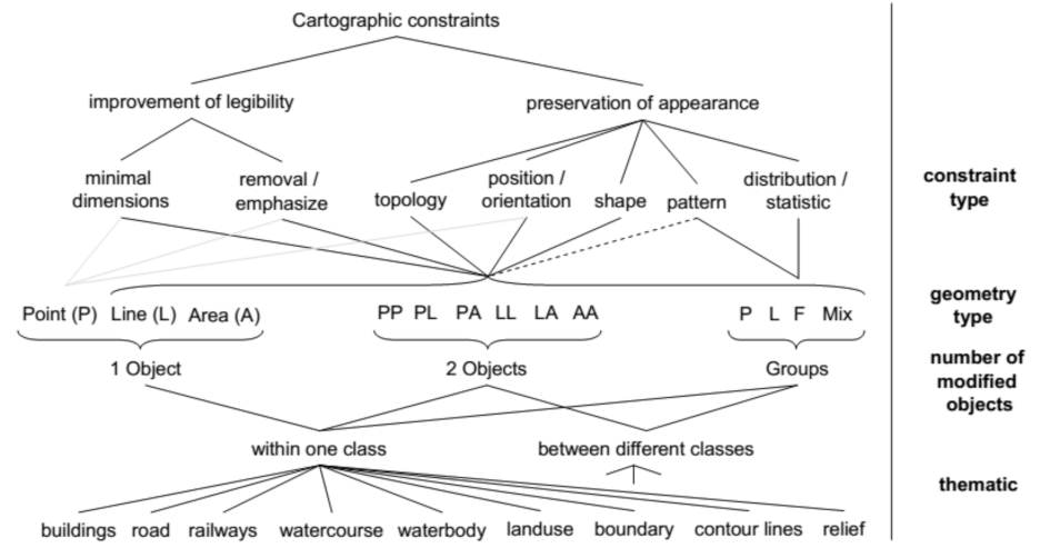
2.1. Map-Quality Concept
- The geometric quality, which pertains to the results of the transformations applied to the geometry of entities and directly impacts the position, the shape and the geometric elements of the entities (vertices, line segments, angles) and, indirectly, the topological relations between them.
- The thematic quality, which concerns the results of the transformations applied to the database schema and impacts the information completeness, the correct classification of the entities based on their definitions, the compliance of the attribute values to the attributes domains and the values correctness.
- The aesthetic/graphic quality (Gestalt), which regards the evaluation of the graphic map quality and the map ability to transfer the thematic information, considering the map as a communication medium [1].
2.2. Conceptual Framework
2.3. Logical Framework
2.4. Quality-Model Application in Semantic Generalization
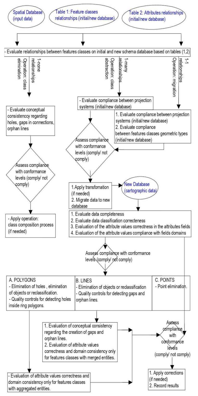
2.4.1. Concept and Operations
- Transfer of all data when there is correspondence between the features classes of both databases (initial database/new database), one-to-one relationship between features classes: ‘migration’.
- Transfer of all data when there is correspondence between many feature classes of the initial database and one feature class in the new database, many-to-one relationship between the features classes: ‘class abstraction’.
- Removal of a class: ‘class elimination’.
2.4.2. Constraints and Measures
- Preservation of consistency in the projection coordinate system of the new database ([19] quality element: logical consistency/format consistency). Conformance level is set to acceptable or unacceptable. The satisfaction of this constraint is assessed by conducting a query to the database (initial/new) about its descriptive features and checking the coincidence of the coordinate systems characteristics of the initial database against the new one.
- Preservation of consistency in geometric types ([19] quality element: logical consistency/format consistency). Conformance level is set to acceptable or unacceptable. Entities with geometric type not compliant with the feature-class geometric type are transformed.
- Preservation of information completeness regarding entities ([19] quality element: completeness/omission). Each feature class in the new database is considered complete when the amount of its data is equal to the amount of data associated with the feature class in the initial database. Conformance level is set to acceptable or unacceptable. This constraint is applicable for ‘migration’ and ‘class abstraction’ processes.
- Preservation of classification correctness. This constraint is applicable for ‘migration’ and ‘class abstraction’ processes and concerns the correct classification of the entities per subtype. Conformance level is set to acceptable or unacceptable.
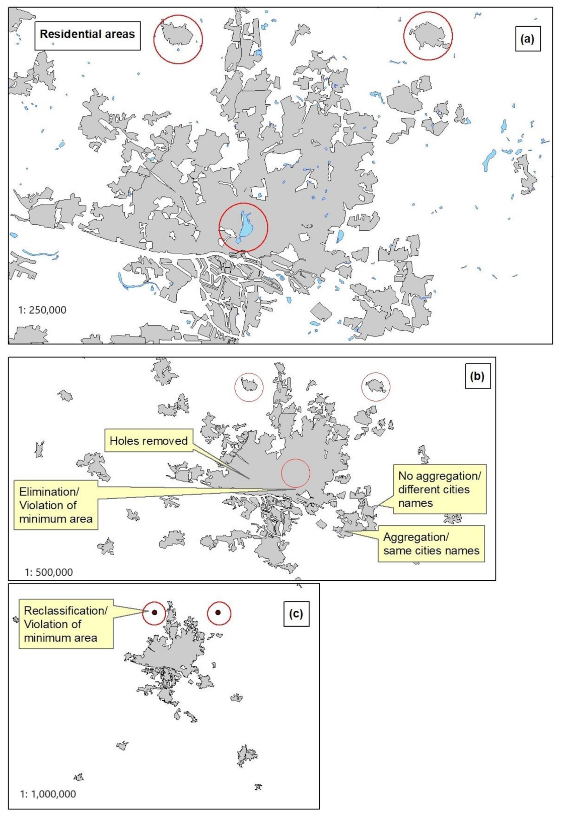
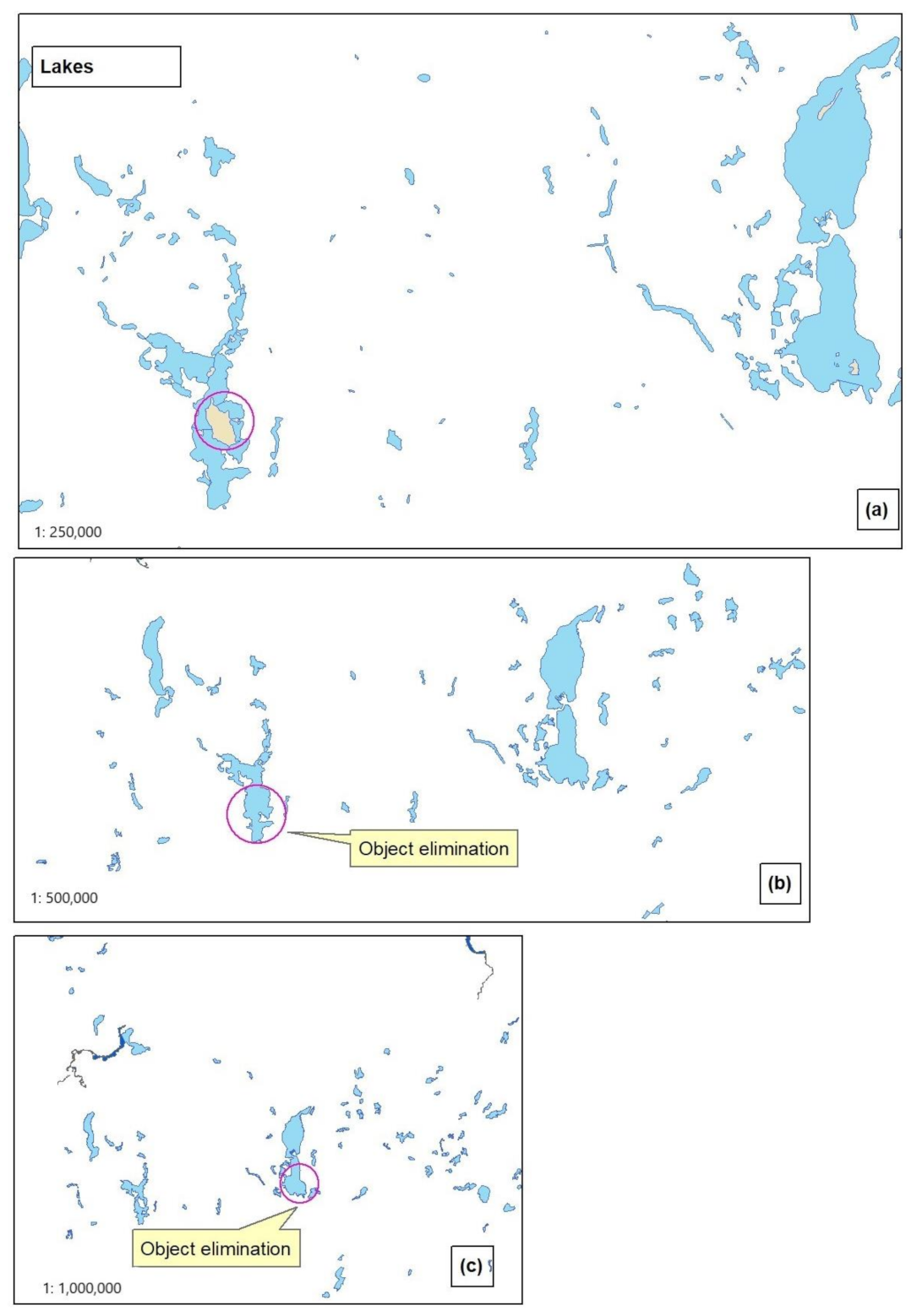
- Preservation of conceptual consistency in the relationships between entities when features classes or features are eliminated (class elimination/feature elimination) ([19] quality element: logical consistency/conceptual consistency). Holes in polygons, gaps between connections and ‘orphan’ connections are not allowed. The measure of “holes” in a polygon is defined by the number of ‘ring’ features found in the feature class. The measure of the gap between connections is defined by the number of missing links. The identification of a gap is performed through counting the dangle nodes in the feature class before and after link elimination considering that the missing link should have the same endpoints with two dangle nodes of two different lines in the feature class. The measure of orphan lines is defined by the number of lines having dangle nodes on their endpoints that do not intersect with other geometric types (polygons, points) in other features classes. Conformance level is set to acceptable or unacceptable.
- Preservation of accuracy in attribute values ([19] quality element: thematic accuracy/non-quantitative attribute correctness) when ‘aggregation’ or ‘merging’ are applied. Attributes values are considered accurate when they are not marked as empty, <null> or <none>. Conformance level is set to acceptable or unacceptable.
- Preservation of accuracy in attributes values of each feature class when the ‘migration’ process is implemented ([19] quality element: thematic accuracy/quantitative attribute correctness). Attributes values are considered accurate when they are not marked as empty, <null> or <none>. Conformance level is set to acceptable or unacceptable.
- Preservation of consistency of the attributes values to the field domain ([19] quality element: logical consistency/domain consistency). An attribute value is considered consistent with the field domain when it receives one of the values (coded values) described in the domain or it is within the range of values (range values) described in the domain. Conformance level is set to acceptable or unacceptable.
- Maintaining the readability of each individual entity using improvement of legibility constraints-minimal dimensions ([19] quality element: completeness/commission) and maintain legibility between different entities of the same feature class ([19] quality element: logical consistency/conceptual consistency). Maintaining legibility between different entities is achieved by using minimum distances based on resolution (0.25 mm) at the generalization scale. Legibility measure between entities is calculated as the length of the remaining items or as the number of remaining items inside a buffer with width equal to resolution. Conformance level is set to acceptable or unacceptable.
- Preservation of information completeness regarding entities in each feature class ([19] quality element: completeness/commission) by maintaining the object compliance to the class intension. Conditions of minimum length or area are usually defined. Conformance level is set to acceptable or unacceptable.
2.4.3. Generalization Process and Quality Controls
- The schema of the new database should be known and the structure of the new database must be compatible with the specifications. The proposed quality model includes the necessary controls to assess the consistency of the new database schema with the specifications but these controls are omitted in this paper for brevity reasons.
- The correspondence between the classes and the attributes of the initial database and the new database should be predefined and based on their definitions. The implementation of the example requires the configuration of two tables incorporating the relations between the classes and the attributes of the initial and the new database, and the execution of the required transformations.
- In case of aggregation or merging entities, the policy of attributes values composition should be predefined.
- Each entity of a feature class should be identified by a unique code (id) to facilitate its retrieval from the original database when required, usually for correcting attributes values.
- Data transfer from the initial database to the new database, according to the correlations prescribed in Table 1 and Table 2 of categories and attributes.
- In case of one-to-one (‘migration’) and many-to-one (‘class abstraction’) relationships between features classes in the initial database and in the new database, the following evaluation procedures are performed in hierarchical order to ensure satisfaction of the set constraints: evaluation of the compatibility of the projection reference system and evaluation of the compatibility of the entities’ geometric type by applying query techniques on the database. In case of incompatibility, an automatic correction is applied and the transformed data are appended to the corresponding class of the new database in accordance with the sub-categories of the feature class. The quality controls are performed in hierarchical order and concern the completeness of the registrations and the correct classification of the entities in the feature class sub-categories. The results are recorded as the number of missing entities and erroneous thematic classification cases. Errors are automatically corrected by retrieving data from the initial database.
- In case of feature class elimination, one-to-none relationship, evaluation procedures are performed based on the geometric type of the associated entities to ensure the conceptual consistency in the database regarding the existence of holes within polygons, gaps between links and ‘orphan’ lines. In case of polygonal entities, the existence of enclosure relations regarding the eliminated features is examined in conjunction with the retained polygonal entities that have a hole. A hole is not permitted to remain in the position of the eliminated entity. A class composition transformation is therefore applied. Similarly, in case of linear connections, gaps are not allowed so they must be identified. For this reason, a technique is applied that includes the calculation of the dangle nodes before and after the removal of a feature class. The gap in the connection is identified when the start/end points of a line in the initial database are identical with the start/end points of two different lines in the new database, which are characterized as dangle nodes. The integration of the eliminated line with the retained line is automatically applied with the retrieval of the eliminated line from the initial database. The attributes values of the aggregated or merged entities are removed. In case of orphan lines, the lines that have dangle nodes at the endpoints and do not intersect with other entities (polygons, points) are characterized as ‘orphans’ and are deleted. The results are recorded as number of conceptual inconsistencies at three levels: ‘holes’, ‘gaps’, and ‘orphan lines’.
- Evaluation of the attribute values correctness in the attributes fields (thematic accuracy/non-quantitative attribute value correctness) is performed by identifying fields with “empty” values. Results are recorded as the number of incorrect attributes field values. Errors are automatically corrected by retrieving data from the initial database.
- Evaluation of the attribute values compliance to field’s domain. Results are recorded as the number of incorrect attributes field values. Errors are automatically corrected by retrieving data from the initial database. Items with attribute values that violate the field’s domain are eliminated in the next level of semantic generalization process.
3. Results and Discussion
4. Conclusions
Author Contributions
Funding
Data Availability Statement
Conflicts of Interest
References
- Mackaness, W.; Burghardt, D.; Duchêne, C. Map Generalisation: Fundamental to the Modelling and Understanding of Geographic Space. In Abstracting Geographic Information in a Data Rich World. Methodologies and Applications of Map Generalisation Lecture Notes in Geoinformation and Cartography; Burghardt, D., Duchêne, C., Mackaness, W., Eds.; Springer: Cham, Switzerland, 2014; pp. 1–15. [Google Scholar]
- McMaster, R.B.; Shea, K.S. Generalization in Digital Cartography; Association of American Geographers: Washington, DC, USA, 1992. [Google Scholar]
- Ehrliholzer, R. Quality assessment in generalization: Integrating quantitative and qualitative methods. In Proceedings of the 17th International Cartographic Conference, Barcelona, Spain, 3–9 September 1995. [Google Scholar]
- João, E.M. Causes and Consequences of Map Generalization; Taylor and Francis: London, UK, 1998. [Google Scholar]
- Weibel, R. Three essential building blocks for automated generalization. In GIS and Generalization: Methodology and Practice; Mueller, J., Lagrange, J.P., Weibel, R., Eds.; Taylor & Francis: London, UK, 1995; pp. 56–70. [Google Scholar]
- Brazile, F. Semantic Infrastructure and Methods to Support Quality Evaluation in Cartographic Generalisation. Ph.D. Thesis, Department of Geography, University of Zurich, Zurich, Switzerland, 2000. [Google Scholar]
- Mackaness, W.; Ruas, A. Evaluation in the map generalisation process. In Generalisation of Geographic Information: Cartographic Modelling and Applications; Mackaness, W., Ruas, A., Sarjakoski, T., Eds.; Series of International Cartographic Association; Elsevier Science: Amsterdam, The Netherlands, 2007; pp. 89–111. [Google Scholar]
- Stoter, J.; Zhang, X.; Hanna, S.; Harrie, L. Evaluation in Generalisation. In Abstracting Geographic Information in a Data Rich World. Methodologies and Applications of Map Generalisation Lecture Notes in Geoinformation and Cartography; Burghardt, D., Duchêne, C., Mackaness, W., Eds.; Springer: Cham, Switzerland, 2014; pp. 259–297. [Google Scholar]
- Stoter, J.; Post, M.; Van Altena, V.; Nijhuis, R.; Bruns, B. Fully automated generalization of a 1:50 k map from 1:10 k data. Cartogr. Geogr. Inf. Sci. 2014, 41, 1–13. [Google Scholar] [CrossRef]
- Regnauld, N.; Touya, G.; Gould, N.; Foerster, T. Process Modelling, Web Services and Geoprocessing. In Abstracting Geographic Information in a Data Rich World. Methodologies and Applications of Map Generalisation Lecture Notes in Geoinformation and Cartography; Burghardt, D., Duchêne, C., Mackaness, W., Eds.; Springer: Cham, Switzerland, 2014; pp. 197–225. [Google Scholar]
- Duchêne, C.; Baella, B.; Brewer, C.; Burghardt, D.; Buttenfield, B.; Gaffuri, J.; Käuferle, D.; Lecordix, F.; Maugeais, E.; Nijhuis, R.; et al. Generalisation in Practice Within National Mapping Agencies. In Abstracting Geographic Information in a Data Rich World. Methodologies and Applications of Map Generalisation Lecture Notes in Geoinformation and Cartography; Burghardt, D., Duchêne, C., Mackaness, W., Eds.; Springer: Cham, Switzerland, 2014; pp. 329–391. [Google Scholar]
- Duchêne, C.; Touya, G.; Taillandier, P.; Gaffuri, J.; Ruas, A.; Renard, J. Multi-Agents Systems for Cartographic Generalization: Feedback from Past and On-going Research. Research Report, IGN (Institut National de l’Information Géographique et Forestière); LaSTIG, équipe COGIT. 2018. Available online: https://hal.archives-ouvertes.fr/hal-01682131/document (accessed on 28 February 2022).
- Sarjakoski, T. Conceptual models of generalization and multiple representation. In Generalisation of Geographic Information: Cartographic Modelling and Applications; Mackaness, W., Ruas, A., Sarjakoski, T., Eds.; Series of international Cartographic Association; Elsevier Science: Amsterdam, The Netherlands, 2007; pp. 11–37. [Google Scholar]
- Beard, K. Constraints on rule formation. In Map Generalisation: Making Rules for Knowledge Representation; Buttenfield, B.P., McMaster, R.B., Eds.; Longman Group: Harlow, UK, 1991; pp. 121–135. [Google Scholar]
- ISO 9001:2015. Quality Management Systems—Requirements. Available online: https://www.iso.org/standard/62085.html (accessed on 28 February 2022).
- Stoter, J.; Baella, B.; Blok, C.; Burghardt, D.; Duchêne, C.; Pla, M.; Regnauld, N.; Guillaume Touya, G. State-of-the-Art of Automated Generalization in Commercial Software; EuroSDR Publication: Amsterdam, The Netherlands, 2010. [Google Scholar]
- Burghardt, D.; Schmid, S.; Stoter, J. Investigations on cartographic constraint formalisation. In Proceedings of the Workshop of the ICA Commission on Generalization and Multiple Representation at the 23nd International Cartographic Conference ICC, Moscow, Russia, 4–10 August 2007. [Google Scholar]
- Regnauld, N.; McMaster, R.B. A synoptic View of Generalisation Operators. In Generalisation of Geographic Information: Cartographic Modelling and Applications; Mackaness, W., Ruas, A., Sarjakoski, T., Eds.; Series of International Cartographic Association; Elsevier Science: Amsterdam, The Netherlands, 2007; pp. 37–66. [Google Scholar]
- ISO 19157:2013. Geographic Information—Data Quality. Available online: https://www.iso.org/standard/32575.html (accessed on 28 February 2022).
- AGENT. Selection of Basic Measures. Technical Report C1, Agent Consortium. Available online: http://agent.ign.fr/deliverable/DC1.html (accessed on 28 February 2022).
- Nyerges, T. Representing Geographical Meaning. In Map Generalization: Making Decisions for Knowledge Representation; Buttenfield, B., McMaster, R., Eds.; Longman Scientific Publications: London, UK, 1991. [Google Scholar]
- EuroGlobalMap Pan-European Database at Small Scale, Specification and Data Catalogue v.10, EuroGeographics. 2021. Available online: https://eurogeographics.org/wp-content/uploads/2021/03/EGM_2021_DataSpecification.pdf (accessed on 28 February 2022).
- EuroRegionalMap Pan-European Database at Medium Scale, Specification Version for ERM 2021, EuroGeographics 2021. Available online: https://ome-download-data.s3.eu-west-1.amazonaws.com/euro-regional-map/documents/ERM_2021_Specification.pdf (accessed on 28 February 2022).


| Feature Class (Initial Schema) | Geometric Type | Class Definition | Feature Class Code | Transformation | Feature Class (New Schema) | Geometric Type | Feature Class Code | Class Subtype |
|---|---|---|---|---|---|---|---|---|
| AIRFLDA | Polygon | Airport/Airfield | GB005 | CLASS ABSTRACTION | AIRFLDP | Point | GB005 | 1 |
| AIRFLDC | Point | Airport/Airfield | GB005 | ELIMINATE | 9999 | 9999 | 9999 | 9999 |
| AIRFLDP | Point | Airport/Airfield | GB005 | MIGRATE | AIRFLDP | Point | GB005 | 1 |
| LAKERESA | Polygon | Reservoir | BH130 | CLASS ABSTRACTION | SHOREL | Polyline | BH210 | 1 |
| BUILDP | Point | Building | AL015 | ELIMINATE | 9999 | 9999 | 9999 | 9999 |
| Feature Class (Initial Schema) | Attribute | Feature Class (New Schema) | Attribute | Transformation |
|---|---|---|---|---|
| AIRFLDP | USE | AIRFLDA | USE_ | MIGRATE |
| AIRFLDP | USE | AIRFLDP | USE_ | MIGRATE |
Publisher’s Note: MDPI stays neutral with regard to jurisdictional claims in published maps and institutional affiliations. |
© 2022 by the authors. Licensee MDPI, Basel, Switzerland. This article is an open access article distributed under the terms and conditions of the Creative Commons Attribution (CC BY) license (https://creativecommons.org/licenses/by/4.0/).
Share and Cite
Blana, N.; Tsoulos, L. Constraint-Based Spatial Data Management for Cartographic Representation at Different Scales. Geographies 2022, 2, 258-273. https://doi.org/10.3390/geographies2020018
Blana N, Tsoulos L. Constraint-Based Spatial Data Management for Cartographic Representation at Different Scales. Geographies. 2022; 2(2):258-273. https://doi.org/10.3390/geographies2020018
Chicago/Turabian StyleBlana, Natalia, and Lysandros Tsoulos. 2022. "Constraint-Based Spatial Data Management for Cartographic Representation at Different Scales" Geographies 2, no. 2: 258-273. https://doi.org/10.3390/geographies2020018