Systematic Review

Wildland–Urban Interface: Definition and Physical Fire Risk Mitigation Measures, a Systematic Review

1
Dipartimento Territorio e Sistemi Agro-Forestali, Università degli Studi di Padova, 35020 Legnaro, PD, Italy
2
Dipartimento di Scienze Agrarie, Forestali e Alimentari, Università di Torino, 10095 Grugliasco, TO, Italy
3
School of Life and Environmental Sciences, The University of Sydney, Camperdown, NSW 2006, Australia
*
Author to whom correspondence should be addressed.
Fire 2023, 6(9), 343; https://doi.org/10.3390/fire6090343
Submission received: 12 August 2023 / Revised: 26 August 2023 / Accepted: 30 August 2023 / Published: 1 September 2023

Abstract

:
Due to the associated fire risk, the wildland–urban interface (WUI) has drawn the attention of researchers and managers from a range of backgrounds. From a land management point of view, it is important to identify the WUI to determine areas to prioritise for fire risk prevention. It is also important to know the fire risk mitigation measures available to select the most appropriate for each specific context. In this systematic review, definitions of the WUI were investigated and physical mitigation measures for reducing the risk of fire were examined from a land management perspective. The PRISMA 2020 Statement was applied to records published until 31 December 2022 and retrieved from the Web of Science, Scopus, and other research engines. A total of 162 publications from scientific journals and the grey literature were scrutinised and selected for analysis. Only publications providing an original definition of the WUI or proposing physical measures to reduce fire risk at the interface were retained, while those relating to emergency management and social perception were not considered. The risk of bias was reduced by internal cross-assessment by the research team. Definitions of the WUI (n = 40 publications) changed according to the research objective, varying broadly in identification of the anthropogenic and the wildland components of the interface. Terminology varied according to the definition, and the term wildland–human interface (WHI) was found to be more comprehensive than WUI. Methodological definitions of the interface ranged from using aggregated data through to identification of the buildings at risk in the interface with considerable precision. Five categories of physical fire risk mitigation measures (n = 128 publications) were identified: clearance distances, landscaping, wildland fuel management, land planning, and buildings design and materials. The most effective measures were those applied at early stages of urban development, and maintenance of assets and vegetation is crucial for preparedness. This review represents an analysis of scientific evidence on which land managers can base their actions to reduce the fire hazard risk in the WUI. The number of studies investigating the WUI is considerable, but experimental studies and quantitative results are scarce, and better communication and coordination among research groups and land management agencies is advisable. This systematic review was not registered.

1. Introduction

Wildland fires regularly gain public attention during the fire season, as dramatically observed in the last few years in California [1], Australia [2], and Southern Europe [3]. Much of this attention is because this is where many people reside, and businesses and community groups are established. This area, where human and natural environments meet, is most commonly referred to as the wildland–urban interface (WUI). This zone is of particular interest with regards to wildland fire due to its vulnerability to disturbance by fire and its tendency to act as a source of ignition [4].
The original concept of the WUI arose in California during the late 20th century, when a series of wildfires caused unexpected yet consistent losses in neighbourhoods dispersed in the chaparral [5,6]. Similar scenarios have then been observed in other fire-prone areas of the world: Canada, Chile, Australia, Southern Europe, and South Africa [7,8,9,10,11,12].
The reasons for such disasters cannot be ascribed only to wildland fire, a natural disturbance and ecological driver in many ecosystems [13,14], nor to the sole presence of human settlements, many of which have been present historically. New forms of inhabiting the rural landscape not based on the use of agro–sylvo–pastoral resources must also be considered [6,15]. Indeed, due to a series of socioeconomic and demographic trends in the last few decades, it has become feasible—and attractive—for people to move away from cities to take advantage of more space, lower costs, and better aesthetics [16,17], or for seasonal recreation [18]. This trend has pushed the creation of scattered settlements near or within wildland vegetation, with considerable consequences in the case of wildfire. The increasing number of high-value buildings that need to be defended and the accumulation of large amounts of plant biomass, which represents a stock of fuel for wildfire, have often overcome the resources available to fire crews [19,20].
In addition, the presence of humans in the interface represents the main source of fire ignitions. Given a predicted increase in number of houses in the WUI and the forecasted changes in climate, the risk of fire in the WUI is going to escalate if countermeasures are not taken [21]. For these reasons, the WUI has risen to the top of the agenda for institutions managing wildland fires [22].
The scientific community was first in pointing out the problem of the WUI [5,23], and, in the last 20 years, offices of public administrations have taken action by implementing policies for managing the WUI. In this sense, one of the first legal frameworks to appear was based on a notice in the Federal Register (66 FR 751) by five US government agencies to allocate funds for the fiscal year 2001 [24] and the introduction of an associated legal definition [4]. The proposed thresholds and WUI definition have, in turn, been used extensively in the US as a baseline for successive scientific studies [25,26,27]. Later, other similar legal frameworks were established in other fire-prone regions around the world, with definitions and legal requirements tailored to meet local needs [26,28,29,30,31].
Despite the relatively simple basis of the WUI—where human and natural environments meet—over time, the definition has become increasingly more complex. New aspects are continually being considered and incorporated. For example, some studies have focused on the role of the WUI in habitat fragmentation and facilitation of invasive species [26,32]. Other studies have considered the effects of human resources in the interface, such as built infrastructure and production facilities [33]. In addition, the augmented availability of ancillary information, such as population demographics and census data, increased computational power, and remote sensing capabilities have been used for systematic identification of the WUI and its geographical delineation [34].
Recognising the abundance of factors and agents involved that make the WUI a complex topic, public agencies have launched long-term awareness programmes [35,36,37] and have supported targeted research projects [38,39]. Academia has also responded by analysing the WUI from various points of view, including the social sciences, ecology, and engineering [40,41]. Some of this research has recently been summarised in noteworthy reviews [42,43,44], although this has not been carried out in a systematic manner, nor have other studies directly addressed land management issues in fire-prone areas (see Appendix A).
The objective of this systematic review is to analyse the current scientific and grey literature produced worldwide on the wildland–urban interface from a land management perspective. In particular, the definition of the WUI and the physical measures used to reduce the associated fire risk are investigated. To our knowledge, no such assessment currently exists (see Appendix A), and the outputs will be of use to decision-makers at any administrative level.

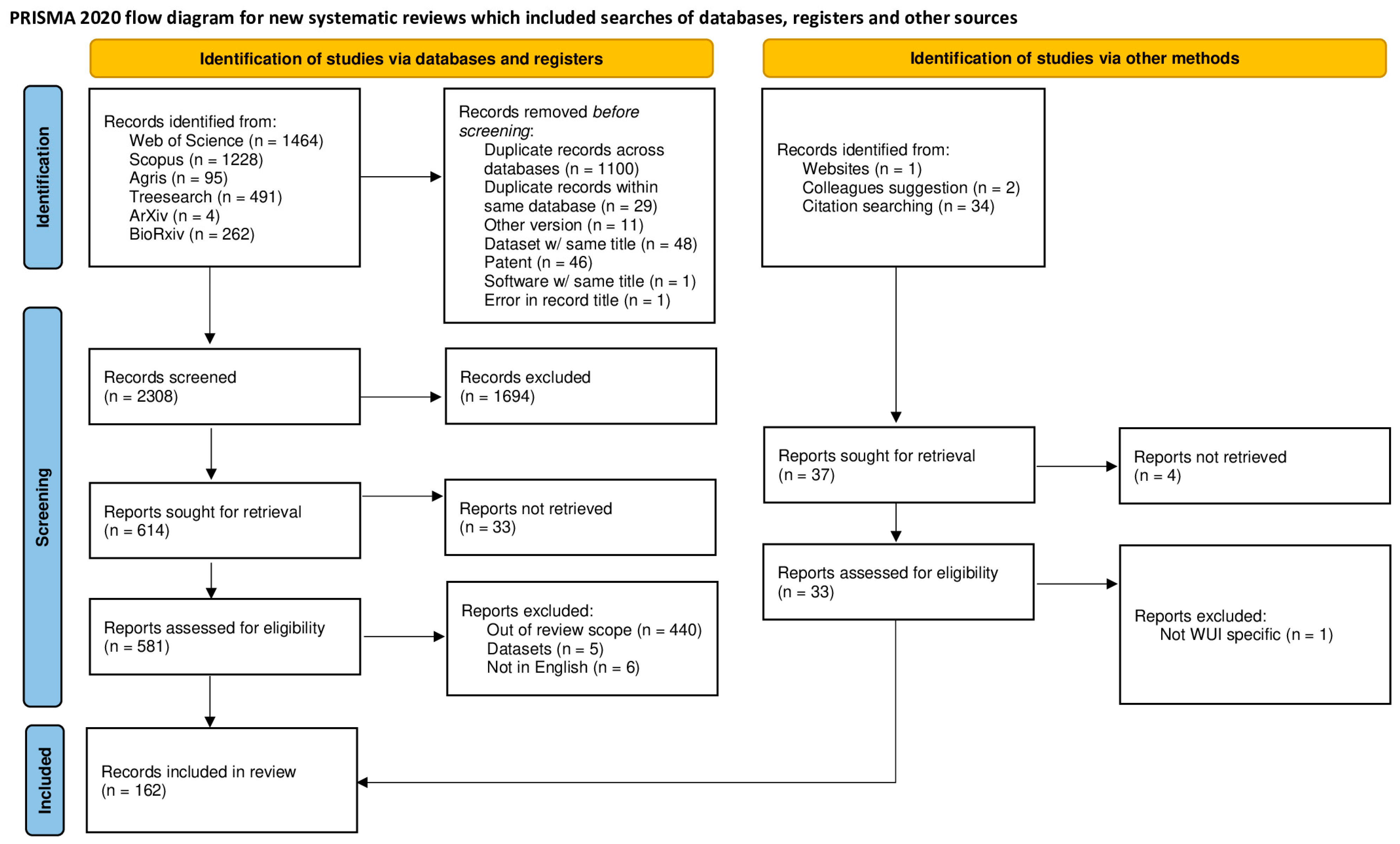
2. Materials and Methods

As the initial step, a thorough search for similar, already existing systematic reviews was performed (Appendix A). No equivalent reviews were found, so the current systematic review was initiated in accordance with the PRISMA 2020 Statement [45].
Studies including a definition of the WUI and/or physical measures to reduce fire risk [46] were selected as eligible, while studies related to emergency management and social sciences were excluded, because they are not directly related to land management. Studies concerning other topics, but from which useful information could be retrieved, were retained. An additional exclusion criterion was the document type: editorials, position papers, forewords, and similar commentary papers were not considered, as well as theses. Publications describing fire risk mitigation measures without inclusion of additional experimental or meta-analyses were also excluded, but, when possible and relevant, studies cited in these publications were retrieved.
The databases accessible through Scopus [47], Web of Science [48], Agris [49], Treesearch [50], arXiv [51], and bioRxiv [52] were searched with the keywords “urban AND interface AND fire” up to 31 December 2022. No filters were imposed with case-by-case selection after retrieval. External entries were obtained from other research engines (Google [53] and Google Scholar [54]), from bibliographies of retrieved publications, and from suggestions by colleagues. These publications were contextually checked for duplication and eligibility. Only full text, readily available publications were retained in the process. Data used for further analysis were retrieved by reading the full text of the publications collected at the final stage of the selection.
The objective of the review was determined using the question formulation framework of PerSPEcTiF [55] (Table 1), and was derived from both the outputs of previous research projects [38,39] and consultation among the authors. The results were presented using a narrative synthesis as defined in the SWiM guideline [56] as the scarcity of numerical results precluded a meta-analysis.
To make the synthesis useful for land managers, two important aspects were considered: firstly, the definition of the WUI, and secondly, a collection of critical measures to reduce fire risk in the area defined. For the definition of the WUI, three questions were addressed: conceptual (what the WUI is), semantic (how people name it), and methodological (how it is identified and mapped). For investigation of preventive mitigation measures to reduce fire risk in the interface, five logical categories were developed based on the publications screened to search for similar existing reviews (as provided in Appendix A):
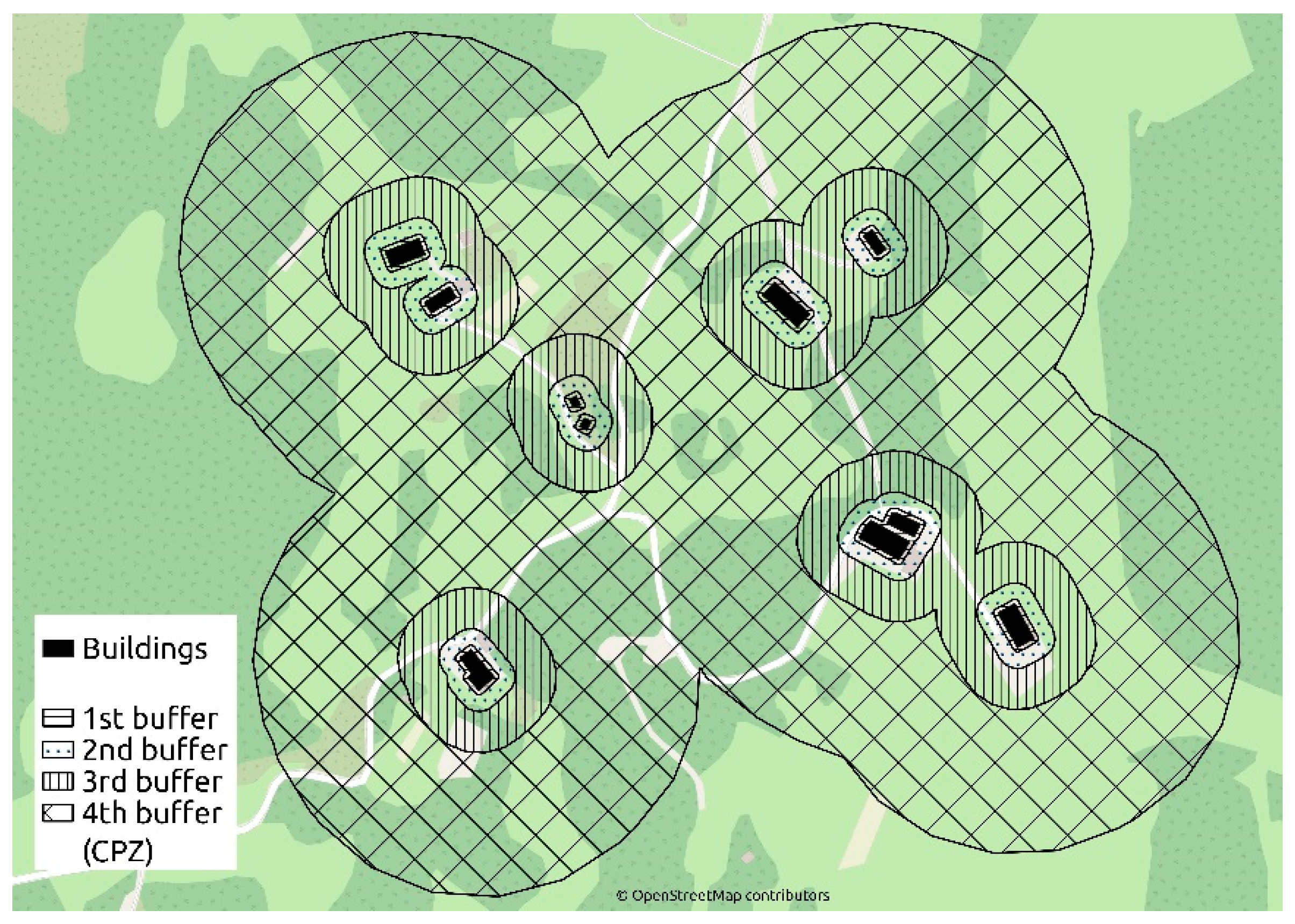
  • Clearance distances (between buildings and plants, and amongst each of the constituents).
  • Landscaping.
  • Wildland fuel management.
  • Land planning.
  • Buildings design and materials.
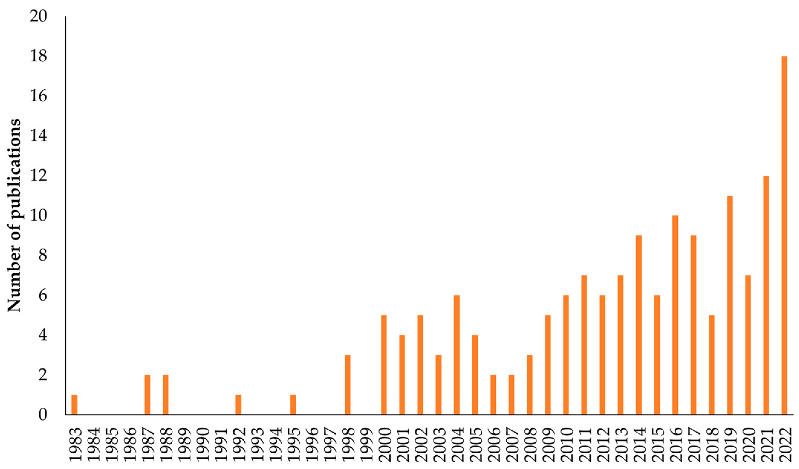
Integrative information on the review process is presented in Appendix B.

3. Results

A total of 3578 publications were retrieved, 3583 using research keywords and 37 as external entries (Figure 1). After deletion of duplicates, screening, and selection for eligibility, 162 publications were used for the final stage of selection. All publications retained (subsequently referred to as the publications) were in English and at a published stage. To investigate the definition of the WUI, 40 publications were used, while 128 publications were used to collect mitigation measures for fire risk, with six publications serving both purposes.
The time range of publication was 1983–2022. There was a steady increase in the number of publications throughout the period, with a peak in 2022 (18 publications, Figure 2).
Location of the studies presented in the publications was strongly concentrated in northern America (US, n = 44; Canada, n = 8), Oceania (Australia, n = 12; New Zealand, n = 1), and Europe (n = 37), with fewer studies from South America (n = 9) and Asia (n = 1). Nonetheless, a large number of publications were derived from laboratory or desk analyses (n = 37) or did not refer to a specific geographic region (n = 14).
Most publications were peer-reviewed (n = 141; 87%) based on their publication in a scientific journal or as part of a conference proceedings (peer-revision of proceedings was assumed for all conferences). The remaining publications were considered as grey literature (e.g., agencies publications, outreach material).

3.1. Definition of the Wildland–Urban Interface

3.1.1. Conceptual Definition

Considering the conceptual definition, the WUI was always determined by at least two components: the wildland—a portion of land under low anthropogenic influence—and a human-altered part of the landscape. A number of studies considered residential buildings as the only anthropogenic component in the WUI (n = 7) [9,11,22,24,57,58,59], while others did not define which kind of human assets to consider (n = 8) [15,25,27,34,60,61,62,63]. Some studies clearly stated that both buildings and other infrastructure (n = 3) [64,65,66], or houses and industrial areas (n = 3) [67,68,69], were considered, while few studies (n = 2) accounted comprehensively for infrastructure, industrial, and residential areas [33,70]. Only one publication considered any human presence (ecumene) as the anthropogenic component of the interface [71]. In addition, a small number of publications focused on a specific human asset, as either infrastructure [72], industrial areas [73], or agrarian land [66,74].
Three studies added a third component to their definition of the WUI—the occurrence of wildland fire [60,75,76]. Another conceptual categorisation of the WUI was used to describe the grade of mingling of human and natural components: (i) wildland–urban interface sensu stricto if the human assets abut wildland, (ii) wildland–urban intermix if human assets are dispersed within the wildland, (iii) occluded WUI if an island of vegetation is surrounded by human assets, and (iv) rural WUI if clusters of assets are widely scattered across a landscape [4].

3.1.2. Semantic Definition

For the semantic definition of the interface, the majority of studies (n = 30 publications) referred to it as the wildlandurban interface (WUI), and in three studies it was called the wildlandhuman interface (WHI) [33,70,71]. The following definitions were used in one or two studies each: urbanforest interface [68], wildfire interface zone [60], ruralforest interface (RUI) [66], roadforest interface [72], forest–settlement mixing zone [77], forestagricultural interface (FAI) [75], forestgrassland interface (FGI) [75], wildlandanthropic interface (WA) [63], wildlandindustrial interface (WUIInd, WII) [71,73], wildlandinfrastructure interface (INF) [71], and wildlandagricultural interface [74]. Three publications [60,61,78] gathered multiple definitions from other studies (Table 2). Some of these terms were used in other studies to refer to a specific condition of the WUI, including fringe [9], peri-urban [9], and rural [9,15,60,66].

3.1.3. Methodological Definition

The two main classes of methodological definitions of the WUI were related to (i) the density of the assets (i.e., buildings) or (ii) inclusion of a buffer around the assets. A further class was (iii) a combination of asset density and buffer distances. Definitions including asset density were the most prevalent (n = 12 publications) [9,11,15,24,25,27,33,57,66,76,79], compared to definitions including a buffer (n = 7) [22,64,65,69,70,75,80] and a combination of the two (n = 8) [58,59,61,62,63,67,77,81]. The “density” definition was most commonly in the US (n = 5) [24,25,27,57,76] compared to the combined definition (n = 2) [59,61], but there was no clear pattern for methodological definitions in publications originating from other countries. There was no clear relation between the year of publication and the class of methodological definition used.
Eight of the studies examined used other methodological definitions. These were based on settlements morphology [68], population income [82], plant species communities [72], cadastral and LiDAR data [34,83], probability of wildfire occurrence [60], buffer from wildland areas [84], property rights and orthophotographs [12], and normative classification [74,85].

3.2. Fire Risk Mitigation Measures in the Wildland–Urban Interface

Mitigation measures for fire risk were searched according to five categories (i.e., clearance distances, landscaping, wildland fuel management, land planning, and building design and materials), which were further grouped as (i) measures acting on natural fuels and (ii) measures for protection of human assets. This rationale simplified data presentation and interpretation and better reflected the two physical components of the WUI. In addition, the two groups are directly related to two major components of fire risk: hazard and exposure, respectively [46]. Summary information relating to the five categories can be found in Appendix C.

3.2.1. Natural Fuels

Mitigation measures for natural fuels included the first three categories: clearance distances, landscaping, and wildland fuel management. The most common configuration of cleared spaces was the creation of concentric buffers stripes of managed vegetation around buildings with reduced management intervention further away. Four buffers could be delineated (Figure 3; Table 2 and Table 3), although no publication considered all of them together, and their width was derived from experiments, simulations, retrospective case studies, or customary practices. The first three buffers are variously referred to as the home ignition zone (HIZ [86]) or house defensible space, and span the first tens of metres (Table 3) [62,78,86,87,88,89,90,91,92,93,94,95,96]. The HIZ is the zone where ornamental vegetation should be maintained to reduce the probability of building ignition by contact, convective, and radiative heat, and to reduce the creation of flying embers [5,12,36,64,86,87,88,89,91,93,95,97,98,99,100,101,102,103]. A multiplication factor is applied to buffer width in case of steep slopes or particularly high natural fuel load [98,100,104]. The fourth buffer zone is referred to as the community protection zone (CPZ [99]), and is similar to an HIZ, but protects groups of buildings. The CPZ spans hundreds of metres from infrastructure (Table 3) [59,64,97,99,105,106,107,108,109,110].
In instances where landscaping was proposed as a method for fire risk mitigation, appropriate design and maintenance were considered to be more important than plant species selection [92,117]. Herbaceous and woody ornamental vegetation (shrubs, trees) should be discontinuous, both horizontally (i.e., between plants) and vertically (i.e., between trees canopies and understorey) to reduce fire spread and, for the same reason, trees should not be planted too close to buildings [5,89,98,103,113,118,119,120]. Periodical maintenance in the form of trimming, mowing, and removing residues is needed to maintain this discontinuity and avoid buildup of combustible fuel (Table 4) [5,31,88,89,94,98,109,114,116,120,121,122]. Additional recommendations included watering plants and mulching against weeds [5,40,88,89,98,101,109,117,120,123,124,125]. For selection of plant species, preference is given to plants that retain a high amount of water in their tissues, such as deciduous broadleaves, succulents, and drought-tolerant species. Plants rich in resins, oils, and volatile organic compounds should be avoided as they can potentially increase flammability, as should plants with needle-shaped leaves, such as conifers, as these structures have high surface area/volume ratios that facilitate combustion (Table 4) [5,36,88,111,119,120,126,127,128,129,130,131,132,133,134,135,136,137,138,139,140,141,142,143].
Wildland fuel management comprises various practices implemented beyond the HIZ to reduce fire risk near assets. Most of the management practices mentioned were aimed at hampering crown fires by removing ladder fuels (fuels between the ground and trees canopy), thus reducing the probability of crown fire [100,119,144,145]. Another recommended management practice was thinning trees to reduce the probability of crown-to-crown fire spread [36,89,98,100,108,144,145,146,147,148,149,150]. Specific management practices included disposal of debris from forest operations [36,98,144,146], and fuel management appropriate for grasslands or shrublands [5,89,151,152,153,154]. At a broader scale, fuel discontinuity is achieved by clearing strips of vegetation. These areas are called firebreaks if all vegetation is removed to impede the spread of fire [155,156,157,158]; fuelbreaks if vegetation is reduced for firefighters deployment [154,156,159]; and greenbelts if vegetation is managed along linear infrastructures or boundaries [5,89,90,101,108,143,160].
At a landscape level, fuel discontinuity was proposed for risk mitigation with land cover fragmentation, favouring land cover with low fuel load (e.g., cultivated land) amid fire-prone vegetation (e.g., coniferous forest) [8,119,129,135,136,137,152,154,161,162,163,164,165,166,167,168,169]. As for landscaping measures, conservation of a target fuel load requires periodical maintenance [89,98,108,109,147,149,167]. This is often achieved with prescribed burning (PB)—the practice of reducing wildland fuel by burning under controlled conditions. A series of precautions to reduce smoke emissions and to minimise environmental harm have been suggested in relation to PB [98,101,108,109,119,167]. For other treatments of wildland vegetation, such as forest thinning, advice was provided to reduce negative ecological impacts, for example, on forest regeneration [31,36,89,98,144,170]. While there was no consensus on what human assets to prioritise with landscape treatments (e.g., buildings, roads, or the most fire-prone areas [25,69,100,104,106]), it is clear that it is more efficient to protect communities instead of single buildings, to coordinate among communities, and to treat big areas instead of small patches. In addition, treatments should be implemented first in the interface sensu stricto, then in the wildland–urban intermix, and lastly around isolated houses in the wildland (Table 4) [20,99,161,171,172].

3.2.2. Anthropic Assets

Fire risk mitigation measures for anthropic assets concern the last two categories: land planning, and buildings design and materials.
Land planning was found to be more influential on fire effects than topography and vegetation in the WUI [102,173,174,175]. The main recommendation was to build in compact settlements which can be better defended in case of fire because of smaller exposed perimeter and better access for fire crews [64,108,116,137,175,176,177]. In addition, constructions on certain topographical features (e.g., ridge tops) were discouraged as they are more exposed to heat and smoke, although those locations are preferred by residents for aesthetic qualities [5,89,92,101,102,120,175,176]. Special mention was given to the road network, considered as a source of ignitions [160,168,169,178,179,180] but also an obstacle to fire propagation [108,159,179].
Mitigation actions for single buildings can be performed by the owner, and often to already existing structures (i.e., retrofitting). In response to building design, the main recommendation was to avoid spaces where firebrands can accumulate (e.g., corners, wooden decks), and to adapt existing ones (e.g., chimney, gutters) [5,102,120,122,181,182,183,184,185,186,187,188]. With reference to building materials, inert materials were suggested for roofs and walls [5,89,92,94,101,102,103,120,122,175,185,185,187,188,189,190,191], and specialised materials should be used for windows and frames [5,103,122,175,187]. Proper maintenance of buildings is also crucial: old houses have a higher probability of burning, and all types of roofs become ignitable with ageing [94,103,175,182,192]. Simple maintenance actions, such as removing debris from gutters, roofs, and at the base of exterior walls, can result in effective reduction of ignition [5,87,120,122,182,188,192]. The measures proposed for buildings also apply to temporal dwellings, such as mobile homes and tents [122,193]. Additional measures can increase building survivability during a fire, such as keeping fuel (e.g., wood piles, LPG tanks) away from buildings [5,92,103,188,194,195,196,197,198], and taking measures to facilitate rescue operations during a fire [5,89,120,188].
Table 4. Synthesis of fire risk reduction measures collected in the present systematic review with selected reference publications.
MeasurePublication
Natural fuel management
Reduction of vegetation in concentric buffers around assets, with greater clearing efforts near assets.[20,59,97]
Periodical management of vegetation by trimming, pruning, watering, and removal of debris.[31,89]
Avoidance of fire-prone plant species in gardens and parks.[88,130]
Increase trees canopy/crown base height and reduction of canopy continuity.[98,145]
Creation of fuelbreaks/firebreaks in wildland vegetation to reduce fire spread and facilitate fire suppression.[155,159]
Land cover fragmentation and some types of land cover hinder fire spread.[8,152,162]
Configuration of human assets
Compact settlements are more easily protected by fire crews and with less perimeter exposed to fire.[64]
No building on steep slopes or ridges.[176]
Road network design should facilitate egress and fire suppression operations.[90,108]
Roof and walls built of inert material.[189,192]
Windows with tempered, double-pane glass.[175]
Avoid creating spaces where embers can accumulate.[5]
Store domestic fuel (LPG, firewood) away from buildings and vegetation.[92,195]
Maintenance of buildings, and removal of leaves from roofs, gutters, and near walls to prevent ignitions.[87,94]

4. Discussion

The studies selected for this systematic review were published over the last four decades and across most of the world, with an expected increase in number of publications in recent years [199], and a focus on Western countries [200]. Grey literature formed a minor share of the selected publications, but some documents in this category were used throughout much of this review [5,31,89,97,188]. This can be ascribed to the scope of grey literature, to collect the information acquired with scientific research, and to synthesise it for the general public, both in the form of outreach material [5,89,188] and as prescription [31,97].
Two main limitations are present in this review: the heterogeneity within selected studies, and the scarcity of numerical outcomes. For these reasons, no formal assessment of the risk of bias, within and across studies, was possible, and no meta-analysis was performed. Homogeneity in definitions, methodologies, and recommendations was mostly only found in studies produced by the same research group. With regard to the scarcity of direct measurements, several studies did not perform empirical experiments, but instead retrieved numerical inputs from the few seminal works containing data. Related to this last point, some publications (excluded in the selection process) used “WUI” or similar terms without actually addressing this topic, using them only as keywords to attract the attention of the readers.

4.1. WUI Definition

The analysis of definitions used for the WUI examined concepts, terms, and methods used over time and tried to clarify their usage. The conceptual, semantic, and methodological aspects of WUI definition are interdependent; therefore, an ultimate definition is probably not achievable. Given a specific aim, appropriate terms are selected, and a method (e.g., mapping) is chosen [201]. The relationship between concepts and semantics were evident in some studies, for example, those describing the influence of road networks or agrarian land on wildland fires in which new terms were created to define the interface [66,72].
Apart from some exceptions, “wildland–urban interface” was the most used expression. There are two obvious reasons for this: (i) use in legislation [24], and by early [202] or seminal studies [20,25,202], and (ii) in most studies, the human component of the interface was a residential area where the term “urban” is appropriate. However, there is emerging evidence of forest fires threatening industrial areas, becoming natural hazards triggering technological disasters (NATECH) [203]. In addition, the negative consequences of new settlements on ecosystems are rarely considered and exceed land cover modification (i.e., increase in ignitions, change in fire regime) [26,32,169,204]. To account for nonresidential assets and to rebalance the importance of both sides of the interface, new terms such as the wildland–human interface (WHI) [33,71] or the wildland–anthropic interface (WA) [63] have been proposed and can be used as a general substitute for the WUI.
The interdependence of the three aspects of the definition of WUI is also evident in mapping methods. In the US, the predominance of methods based on aggregated data may be derived from local legal definitions based on asset density [24] and the computational power available at the time of the law enactment. This scenario creates a natural baseline for local research [25]. In the rest of the world, in the absence of similar legislation, novel mapping methods have been explored. Density-based methods are resource-efficient, especially for estimates and for large areas, and can benefit from data already acquired (e.g., periodical censuses, demographics) [25]. Even today, when temporal trends are investigated, new maps are created incorporating past methods [27,205]. However, as computational power and accessibility to remote sensing data are continuously increasing, finer-scale definitions of the interface based on vegetation and buffer distances are both feasible and desirable, even at a national level [84]. In reality, the retention of the topographic location of assets can better represent the real extent of the interface [57,70,110,205] and can translate to better allocation of resources for fire risk mitigation. In this sense, methods based on LiDAR and cadastral data appear to be the current state of the art for interface mapping [34,83].
Fine-scale mapping can also permit additional analyses to better characterise the fire risk: in fact, all studies considered the interface as the geographical intersection between a natural area and an anthropic one [44], but few publications explicitly considered the presence of wildland fires, the third and necessary component of interface fire risk [60,75,76]. Mapping the probability or the simulated intensity of fire, as already performed for wildland fires, may enhance the categorisation of the risk throughout populated landscapes [206].
In summary, although the most commonly used term was wildlandurban interface (WUI) and the most commonly used mapping methodologies were based on density criteria, we suggest adopting the expression wildlandhuman interface, because it better encompasses a range of anthropogenic influences on the interface, and to use nonaggregated topographic data, such as LiDAR, to define the interface with greater precision and, consequently, the areas to prioritise for management.

4.2. Fire Risk Mitigation Measures in the WUI

The analysis of measures to reduce fire risk in the interface divided them into those acting on natural fuel and those targeting human assets. The ones acting on natural fuels were related to distances for clearing vegetation, landscaping practices, and managing wildland fuel. Those targeting human assets relied mainly on land planning practices and construction of buildings.
Regarding clearing distances, only one study validated data obtained from simulation [20,112] with a field experiment [111], showing a general lack of studies using direct measurements [95,207]. Simulations are often used because they are relatively inexpensive, but estimated data required to run models may lead to inaccurate outputs [95,157]. Retrospective case studies, especially post-incident surveys, are valuable sources of information, but the knowledge of the prefire situation represents a bottleneck, especially in the case of remote sensing analyses [10,102,110,116,119,180,208,209,210]. “Common sense” distances are widespread, especially in legislation [28,29,30,31], and are easily accepted because they reflect local experience of fire behaviour, but may underestimate fire risk in the case of unprecedented conditions. Clearing distances depend on local climate and vegetation and may be inapplicable out of context [62,97,116]. Realistically, one-size-fit-all distances for clearing cannot be suggested, but management of vegetation in concentric buffers around assets with the maintenance of good aesthetical and ecological levels of the surroundings can be balanced to protect buildings and other assets.
Landscaping in the interface, or firescaping, as the practice is occasionally called [211], follows the same concentric rule, with more attention required close to assets. It relies on two key concepts, to break fuel continuity within assets and between assets and vegetation, and to reduce the amount of combustible biomass. Periodical maintenance was the main action for both objectives, and garden design or measures to contain plant growth, such as mulching, can reduce the frequency of maintenance. Most of these publications were set in a US context, changing the effectiveness of such methods in other countries. Proposed thresholds (i.e., distances, type, and frequency of maintenance) would need to be tailored to specific settings to be useful.
Plant species selection was found to be secondary [89] in landscaping and relies on plant traits that influence combustion, not solely on species. Moisture in plants is a heat sink and needs to be vaporised before the dry mass can burn. In contrast, oils and resins are energy reservoirs for combustion, and needle-shaped leaves burn intensely because the biomass is in optimal contact with oxygen due to the high surface-to-volume ratio [88]. Consequently, global lists of fireproof plant species waned in popularity in the early 2000s and listings are now only recommended locally [89,212]. In addition, rankings of species flammability developed though laboratory analysis vary considerably depending on the protocol applied [139]. Another historic landscaping trend was the substitution of native vegetation with putatively less flammable exotic ones, but an increasing awareness of biodiversity conservation and alien species has made this strategy far less popular [213].
Wildland fuel management is designed to disrupt fuel continuity as in landscaping, but forestry-related measures are generally carried out over large areas. The focus is to avoid crown fires because they produce large quantities of flying embers, the main source of interface ignitions [181]. Removal of ladder fuels and reduction of the bulk density of tree canopies can create a park-like forest structure and mimics regions characterised by low-severity fire regimes [36,188]. By far, the most popular management tool to achieve this is prescribed burning, but production of smoke in the WUI creates resistance in urban populations [214]. Regardless of the type of management method used, all fuel treatments need to be applied periodically; otherwise, untreated landscapes can represent unacceptably high fire risk, as in the case of abandoned agrarian fields in Europe [119].
The preferred type of treatments for management of wildland fuel over landscapes differed across studies, reflecting local socioenvironmental conditions. For example, in residential areas, the WUI was found to be managed to protect the greatest number of houses [109], while in rural areas with dispersed buildings, the road network was the primary area treated to reduce ignitions and fire spread [178]. In communities where lightning ignitions were frequent, the most fire-prone areas were prioritised to halt fire penetration into the WUI [215]. A risk mitigation measure found to be effective for slowing the spread of fire across a landscape was land cover fragmentation, for example, achieved by alternating wildland parcels with agrarian fields [154,162]. This pattern is easy to maintain if it is already present in the landscape, whereas if it requires land use change, it is unlikely to be accepted by stakeholders or by the society as a whole [168].
Land planning during development of new settlements is the most efficacious measure for building safety, by reducing both the exposure of buildings to wildfire and creating safe conditions in which to operate in case of fire. Despite this, community-based measures were not recurrent in the publications examined, although they were more efficient than single-properties interventions [103,171,208]. This is possibly due to difficulties in reaching a consensus among residents. Redesigning existing settlements is also contentious due to the cost of retrofitting whole communities and expectations of stakeholders in the WUI, especially a recreational community with residents having little appetite for altered landscapes, changes of scenic views, and reducing distance from other houses.
As a confirmation of the difficulty to intervene at the community level, single building construction and maintenance were the most common topics in the publications examined to reduce WUI fire risk. A large number of publications addressed cleaning and maintaining premises and repairing broken or aged parts, which are common activities for homeowners regardless of location. One reason for this may be the—sometimes large—proportion of owners with second houses in the WUI, who may be less keen than residents to divert leisure time into fire risk reduction activities [18], or who may be absent for most of the year [216]. Another reason for inadequate property maintenance can be underestimation of risk [217]. Such sociological or psychological aspects were not investigated in this systematic review, but have emerged frequently, suggesting an influence on the more tangible aspects of WUI fire risk reduction.
Considering building design and materials, the focus of much of the relevant literature was on reducing the risk posed by the weakest points of a structure, the roof, and the glazing system. Logically, the roof is where most of the flying embers land and smoulder. To some extent, the occurrence of embers can be reduced if other risk mitigation measures are applied [20]. Windows failure allowing egress of embers was often cited as the cause of house destruction [175]. Inert materials are the preferred choice for reducing this fire risk; however, the choice may be overridden by regional habits or availability. For example, common building materials used in Mediterranean countries are concrete or masonry, but in other countries, including the US, Canada, and Australia, they are predominantly wood or composite. In this sense, houses in the Mediterranean are places of shelter [186,216], instead of sources of house-to-house ignitions [103,177]. Nonetheless, flammable materials are common in the Mediterranean for minor structures (sheds, garages [186]) or in campsites [193], indicating that a collection of best practices can be useful worldwide, regardless of local differences in wildland vegetation, fire regimes, and urban settings.

5. Conclusions

This systematic review of the WUI was a much-needed global and comprehensive search for a clearer understanding of what the WUI represents in fire-prone areas around the world, and in examining mitigation measures of fire risk. Regardless of location, the WUI has become the focus of attention for wildland fire management due to the existence of wildland fuel, increasing human presence, and high-value assets.
The definition of the WUI has changed over time and with purpose. Today, the interconnection between human habitation and wildland vegetation is recognised, and precise identification of anthropic assets is both possible and desirable with available technology. The most effective fire risk mitigation measures were those carried out at the planning level and, for established locales, those describing maintenance of vegetation and structures. While some recommendations only have local value, the concepts examined hold true worldwide, signalling that collaborations among land managers and researchers, the latter from different fields, may be beneficial to all. Collaborative research would be best served by designing comprehensive experiments to give quantitative, objective indications on the best configuration of structures and their surroundings to withstand wildland fire at the interface.

Author Contributions

Conceptualization, E.L.; methodology, E.L.; software, F.T.; validation, F.T., R.M., T.L.B., and E.L.; formal analysis, R.M., T.L.B., and E.L.; investigation, F.T.; resources, E.L.; data curation, F.T. and E.L.; writing—original draft preparation, F.T.; writing—review and editing, F.T., R.M., T.L.B. and E.L.; visualization, F.T., R.M., T.L.B. and E.L.; supervision, E.L.; project administration, F.T. and E.L.; funding acquisition, E.L. All authors have read and agreed to the published version of the manuscript.

Funding

This research was partially funded by the European Commission (project Interreg V-A Italy-Slovenia 2014-2020 CROSSIT SAFER) within the European Territorial Cooperation program “INTERREG”.

Data Availability Statement

Data are available in publicly accessible repositories: Scopus, https://www.scopus.com, accessed on 7 March 2023; Web of Science, https://www.webofscience.com, accessed on 7 March 2023; AGRIS, https://agris.fao.org/agris-search/index.do, accessed on 7 March 2023; Treesearch, https://www.fs.usda.gov/treesearch/, accessed on 7 March 2023; ArXiv.Org e-Print Archive, https://arxiv.org/, accessed on 7 March 2023; BioRxiv.Org—the Preprint Server for Biology, https://www.biorxiv.org/, accessed on 7 March 2023.

Acknowledgments

We wish to thank Rolando Rizzolo from Direzione Protezione Civile, Sicurezza e Polizia Locale of Regione Veneto for the fruitful discussions regarding the need for a similar review. We also thank the partners of the CROSSIT SAFER Project for the continuous exchange of ideas on fire risk in the interface.

Conflicts of Interest

The authors declare no conflict of interest. The funders had no role in the design of the study or in the collection, analyses, or interpretation of data.

Appendix A

The existence of similar reviews on the wildland–urban interface was assessed before the start of the work using a systematic approach.
The string of keywords “*landurban interface fire review” (the asterisk acts as a wild card) were used for the first time on 15 March 2019 in Web of Science (WoS), Scopus, and Agris to search for reviews up to that date. The keyword “*land” was used because synonyms of the broad term wildland are frequently used (e.g., bushland in Australia). In addition, this keyword also encompassed other types of land cover, such as grassland, rangeland and brushland [152,162,167], that were deemed relevant for the current study. The research parameters were the most inclusive as possible were selected:
-
WoS—“all years”, “topic”, and “all databases”.
-
Scopus—“article title, abstract, keywords”.
-
Agris—“all languages” and records from aggregators.
Collectively, 115 records were found (59 from WoS, 41 from Scopus, 15 from Agris), which was reduced to 79 after duplicates were removed, and further reduced to 63 after screening the titles. To manage these records, items from Scopus and WoS were exported, respectively, to CSV/.xls files with the designated function, keeping information on title, authors, source, and abstract (and year, for Scopus). The items were then merged into a single spreadsheet, retaining information on the original database (Scopus or WoS) by adding another attribute. Selection of duplicates was performed by hand by ordering entries by title and authors. Screening of titles and abstracts were also performed by hand. For Agris, it was not possible to export records; therefore, removal of duplicates and screening was performed online. After having read some of the publications, it was evident that the keyword *land was not inclusive enough for our purpose [5,33], and was therefore deleted from the search string.
A second search was carried out on 18 March 2019 using the keyword string “urban interface fire review”, with the other options unchanged. Once the 129 publications (65 from WoS, 49 from Scopus, 15 from Agris) were checked for duplicates, 89 records remained. This number was reduced to 42 after title screening, and to three after reading the abstract. Excluded publications were conference proceedings or were concerned with other fields of knowledge (e.g., social sciences, civil protection, hydrology), or were site-limited in scope. Full-text versions of the remaining articles were obtained and read. It was evident that these studies were not overlapping with our proposed research. One of the three remaining publications gathered information on fire behaviour and fire modelling [42]; the second focused on human caused fires [218]; and the third was a foreword of a journal [219].
On 23 January 2020, a similar search was carried out to account for studies published while our review was in progress. In Scopus, two new records were found, but they were only partially relevant and therefore were excluded. One was centred on policies and land planning in Spain [220], and the other examined building codes in the US and Australia [221]. In WoS, five new records were found, again not matching our in-progress review. These concentrated on spotting during uncontained fires [222], policies and mapping methodologies [44], fire ecosystem (dis)services [223], databases for evacuations [224], and evacuation procedures [225]. No new records were found using Agris.
A last search was performed immediately before submission (9 August 2023), for the sole period 2020–2022. In WoS, 43 publications were retrieved, in Scopus there were 21 publications, and 1 in Agris. After deletion of duplicates (n = 24) and reviews published in January 2020 (and therefore already considered, n = 4), titles and abstracts were screened. Only one publication [209] was assessed for eligibility, but it was a methodological study on post-incident surveys.
The preliminary search for similar previous reviews was carried out to identify a key gap in research. This was achieved and, additionally, provided valuable sources of information and improved our review process by refining the underlying research question, eligibility criteria, and the publication selection process.

Appendix B

Integrative information on the review process is presented in this appendix instead of registering a formal research protocol.
The choice of the research engines derived from their popularity in environmental sciences (Web of Science, Scopus) and life sciences (arXiv, bioRxiv), or from the important role of their maintaining agency in providing guidance for land management (Agris, Treesearch). The databases were first accessed on 19 March 2019 and lastly on 7 March 2023, to also include documents published before 31 December 2022.
The keywords used and the eligibility criteria were discussed in Materials and Methods and are presented again here: “urban AND interface AND fire” was used as a search string without imposing other search filters than the date limit. For each research engine, additional research options were selected:
-
In Scopus, keywords were searched for in “article title, abstract, keywords”.
-
In Web of Science (WoS), keywords were searched for in “all databases”, “all collections”, “topic”, and by enabling the “exact search” option.
-
In Agris, a multilingual search was enabled and records that contained explicit link to the full text were considered, while records from aggregators were excluded.
-
In arXiv, keywords were searched for in “all fields”, including “cross-listed papers”.
-
In bioRxiv, keywords were searched for in “all sections” of “all collections”, excluding the medRxiv database.
-
In Treesearch, the search string was “urban interface fire”, removing the logical operator “AND” as it appears to reduce the number of available records.
There were no barriers to accessing information, but in Agris, arXiv, and Treesearch it was not possible to download the list of the records (95, 4, and 491 publications, respectively), while for bioRxiv it was not possible to download records (n = 262) in a spreadsheet format. For this reason, results from these webpages were printed in PDF for examination offline.
In Scopus and WoS, records were exported and organised in spreadsheets, as explained in Appendix A. Totals of 1228 and 1464 publications were retrieved, respectively. These two spreadsheets were later used as a basis to remove duplicates from the printed PDF files.
Additional records were obtained from Google, from bibliographies of retrieved publications, and from suggestions by colleagues. These publications were contextually checked for duplication and eligibility. These records were marked as “external” as they were not obtained in a systematic manner.
Only full-text, readily available publications were retained in the process. Data used for the analyses were retrieved by reading the full text of the publications at final stage of the selection. Eligible studies were those including a definition of the WUI and/or physical measures to reduce fire risk. Ineligible studies were those related to emergency management and social sciences unless useful information could be retrieved from them. Eligibility was also assessed by document type: editorials, position papers, forewords, and presentation papers in general were not considered. Publications presenting fire risk mitigation measures without experimental data or meta-analyses were excluded, but, when possible and relevant, studies cited in these publications were retrieved as external entries.

Appendix C

This appendix aims at reporting more in detail the findings of this systematic review on WUI fire risk mitigation measures.

Appendix C.1. Measures for Natural Fuels: Clearance Distances

The most common recommendation to reduce fire risk in the WUI was the creation of concentric buffers around assets to design and implement fire risk mitigation actions.
Four buffers were identified: the first three protecting individual buildings and spanning tens of metres, and the fourth protecting groups of buildings and spanning hundreds of metres.
The first buffer immediately around a building (0.6–120 m from walls, median 10 m) should be inert to stop ignition by flame contact [5,87,91,93,95,100,103,114,125]. This area can be created with noncombustible materials such as concrete paths, paving blocks, and broken stone, and the width should be at least 3–5 times the height of surrounding grass when uncut [89,99,102,125,188].
The second buffer (range 3–100 m from walls, median 15 m) can be vegetated, but fuel load should be very low to reduce the amount of radiative heat emitted. Mowed herbaceous vegetation is preferred to trees and shrubs, and if these are present, they need to be widely distanced [12,36,99,100,114]. Fire-prone shrubs are discouraged here [5].
The third buffer (28–100 m from walls, median 60 m) can have shrubs and trees, but they need to be maintained with pruning and trimming, and residual biomass must be removed to reduce the amount of convective heat and flying embers impacting buildings [5,12,36,64,86,88,98,99,100,104,114].
The first three buffers can be widened near plantations [97], where natural vegetation has a high fuel load [98], or in case of steep slopes [99].
The fourth buffer zone is intended to protect groups of buildings. It spans for the first hundreds of metres from structures, often 500 m (mode) but ranging from 25 m to 10 km, with a median of 700 m [64,100,104,105,106,107,108,109,110]. One study further divided the fourth buffer into five concentric bands to organise the fuel management treatments (e.g., thinning, prescribed burning) [59].

Appendix C.2. Measures for Natural Fuels: Landscaping

Landscaping can contribute to reduce fire risk in the WUI by reducing available fuel near buildings.
When designing a new garden, the preferred arrangement for herbaceous plants is in raised beds, and in groups or widely spaced for shrubs and trees. A distance of five times their height between shrubs and 4–7 m between trees is advised [5,89,98,113,114,118,120,188].
In already-existing gardens, mulching helps containing weeds growth, but coarse mulch like pine nuggets, pine bark, and hardwood mulch are preferred over pine straw and grass mulch because they are less flammable [40,88,123,124,125,149].
If possible, watering plants, and especially turf, during the dry season reduces their flammability. To reduce the amount of fuel, turf needs to be mowed before the dry season [5,89,98,109,117,120,122]. Likewise, all dead plant material, on the ground or hanging, should be removed, especially litter under hedges [5,88,89,109,120].
To prevent fire transmission between vegetation and buildings, overhanging branches that are touching or near buildings should be removed, as well as branches within 3 m from chimneys. Trees around buildings should be removed for a distance of 10 m or one to two times the height of the trees [5,31,94,98,102].
Trees crown base height has to be raised to 2–9 m above the ground via pruning to avoid torching during wildfire [88,89,98,114,121,188]. To reduce fire spread between crowns, canopy ground cover needs to be low (35–40%) and crowns have to be widely spaced (3–6 m). A rule of thumb is to prune half of the tree canopy by volume every maintenance cycle [89,94,98,103,114,188].
For selection of plant species, preference is given to vegetation that retains a high amount of water in its tissues, such as deciduous broadleaves, succulents, and drought-tolerant species. Plants rich in resins, oils, and volatile organic compounds should be avoided as they can potentially increase flammability. Trees with needle-shaped leaves, such as conifers, have high surface area/volume ratios that facilitate drying and should also be avoided [5,36,88,111,120,126,140,141,142,188]. According to the publications interrogated, species commonly cited to avoid planting in the WUI are Eucalyptus spp., Pinus spp., Juniperus spp., Erica spp., and gorse (Ulex europaeus) [88,126,127,128,129,130,131,132,133,134,139,140,141]. For some species, such as Mediterranean Cypress (Cupressus sempervirens) and Oleander (Nerium oleander), there is no consensus on their hazard level [130,135,136,137,138,139]. If native vegetation is fire-prone, substitution with fire resistant species was recommended [5,98,101,109,117].

Appendix C.3. Measures for Natural Fuels: Wildland Fuel Management

Wildland fuel management applies the same concepts proposed for landscaping to vegetation beyond the home ignition zone.
To avoid vertical fire transmission, from ground to tree canopy, two interventions were proposed: selective thinning, leaving only the biggest trees (>30–50 cm diameter at breast height (DBH)) [36,98,144,146,147,150], and pruning, to raise canopy base height to 4–11 m above ground [100,144,145]. If understorey is retained for regeneration, habitat, or structural diversity, saplings have to be spaced (>4 m) and trees above them removed [36,98,188].
Thinning can also impair horizontal spread of crown fires, without reducing ecosystem services. Proposed targets were 75–400 trees/ha, two-thirds of forest canopy cover, 50% of basal area (BA), 11–27 m2/ha of BA, and 3–6 m between crowns [89,108,144,145,146,147,148,149,150]. For the same reason, a target canopy bulk density of ≤0.1 kg/m3 is advised [100,144].
To reduce the risk of windthrows and environmental disturbance, thinning is best performed in two steps separated by 5–10 years, or on clusters of trees, [36,98,144]. Wood debris from operations must be removed to reduce fire risk. Proposed alternatives were to pile and burn the debris, or to spread it in a shallow (<30 cm) layer [36,98,144,146,154].
In some countries prescribed burning (PB) is used along with thinning, or as its alternative, to maintain the desired forest structure. Before applying PB, debris should be removed or masticated to reduce smoke production, fire severity, and risk of uncontrolled fire. Prescribed burning can be performed up to 250–550 m from houses [98,101,108,109,167,188].
Care should be taken around wetland areas and waterbodies (lakes, rivers, sea) to reduce ecological disturbance and safeguard against wildfire [31,36]. Other means to combine fire risk reduction with environmental protection are to retain old trees, coarse woody debris (stumps, snags, and logs), and ecological corridors, because these habitat features do not appreciably increase fire risk and provide important environmental services [36,89,170].
Wildland fuel management has to be implemented periodically because of fuel buildup. Recommended intervals for thinning are 10–15 years, 2–7 years for PB, and annually for clearing shrubs [69,89,98,108,109,147,149,167]. In grasslands, fuel load can be kept low by mowing and leaving the grass in place, or by grazing livestock [5,89,151,152,153].
At a broader scale, fuel discontinuity can be achieved by clearing strips of vegetation (firebreaks) to stop the spread of fire [155,156,157,158].
For fuelbreaks, some vegetation is retained because the aim is to provide access and a safe defending zone to fire crews. Fuelbreaks should be positioned against fire barriers such as roads, creeks, outcrops, or on top of ridges. In fuelbreaks, tree crowns should be spaced (>3 m, canopy cover < 25%) and lower branches pruned. Only large trees (DBH > 35 cm) should be retained, and dead snags removed. If groups of trees are retained, they must be managed to keep the fuel load low [154,156,159].
Green belts are used to protect linear infrastructures and consist of buffers of managed, less ignitable vegetation on each side of roads (3–10 m) or power lines (5 m) [5,89,90,101,108,142,160]. The side below the road should have a wider buffer to reduce heat transfer by convection [159].
At the landscape level, maintenance of a fragmented land cover reduces wildfire severity in the same way as fuel discontinuity around assets. Agrarian fields, grasslands, and deciduous forests are less prone to fire than grasslands, plantations, or coniferous forests [8,119,129,136,152,154,161,162,163,164,165,166,168,169,188]. Mixed broadleaf–conifer forests may have a lower risk of fire than pure forests [135]. Some studies assign a high risk of fires to shrublands, while others do not [119,137,152,154,162,164,165,166,167,188,225]. One study suggested the conversion of plantations and agrarian fields to fire-adapted native forest [162].

Appendix C.4. Measures for Anthropic Assets: Land Planning

Land planning for new constructions in the WUI has an even greater role than topography or vegetation in risk mitigation [102,173,174,175].
Compact settlements (circular, square) can be better defended in case of wildfire. The perimeter adjacent to neighbouring vegetation, and thus to fire, is smaller and fire crews have quicker access to buildings [64,108,116,137,175,176,177]. Only two studies speculate that the buildings themselves can be a source of ignition if not spaced widely apart [103,177].
Buildings on steep slopes (>20% gradient) and close to ridges (<45 m) are more exposed to anabatic winds and convective heat transfer during fires, and should not be built there, although these locations are preferred by residents for aesthetic views [5,89,92,101,102,120,175,176].
In relation to infrastructure, burying power lines can avoid accidental ignitions during storms [89] and, presumably, during wildfire. The road network can be a source of ignitions [160,169,178,179,180], but can also hinder fire propagation [108,159,179]. Roads need to be multifunctional: wide enough to stop surface fires [108,176], designed to allow fire engines transit [89,90,108,120,176], without dead ends [89,90,92,120], and with cleared buffer stripes (2–30 m) [89,108].

Appendix C.5. Measures for Anthropic Assets: Building Design and Materials

For a single building, mitigation actions can be carried out directly by the owner, at a fraction of the cost of community mitigation actions, and often to already-existing structures (retrofitting).
With reference to building design, roofs are a critical point in relation to wildland fire risk [5,181]. Roofs designed with valley angles greater than 135° showed no ignition when subject to firebrands, because they could not deposit and smoulder [182]. Spaces where firebrands can accumulate should be avoided, such as overhanging roofs, corners, eaves, and post-and-beam foundations [5,102,120,122,181,185,187,188]. Vents, chimneys, and spaces under decks should be covered with metal mesh (5 mm) [5,120,186,187,188].
Other features of houses are a potential entry point for fire [92,103,120] and their safe design should be considered. For example, fences should have a lattice design to allow permeability of heat and wooden fences should be treated with fire retardant [91]. Properly constructed wooden decks can withstand burning under a continuous shower of firebrands [183], do not transmit fire to the adjoining structures [184], and, in some circumstances, may deflect heat and be regarded as a safe area [5].
Preferred building materials for roofs are ceramic, concrete, slate, metal, asphalt, or composite, while wood should be avoided unless treated with retardant [5,89,92,94,101,102,103,120,122,185,187,188,190,191]. Nonetheless, even intact ceramic and concrete tiles may be permeable to flying embers [186,190], and degraded ceramic and asphalt covers can present the same problem [175,182].
Walls should be of inert materials like fibre cement, bricks, stone, and stucco [5,89,92,102,103,120,122,175,185,187,188,189]. Timber buildings can withstand a grass fire if they contain enough moisture [91].
Windows are exposed to high thermal differences during wildfire. Glass should be tempered [5,122,175,187] and preferably in multiple panes [103,122,175,187]. Large windows should be avoided, or at least equipped with fire-resistant shutters [5,102].
Temporary dwellings such as tents and caravans, which are often used for leisure, are particularly vulnerable during wildland fire. Mobile homes burn more readily than permanent ones [102,122,181], and camping tents should be made of fire-resistant material and need to be placed in fuel-free areas [193].
Additional miscellaneous measures can increase building survivability, for example, presenting the house address on a visible reflective sign can facilitate rescue operations [89,120,188]; maintaining a portable gasoline pump to activate roof sprinklers and water pumps in the event of loss of power; keeping a (noncombustible) ladder at hand to reach the roof; installing outdoor taps with rubber hoses to wet building surfaces and surrounding vegetation; allowing swimming pools to be used as a water resource for firefighters [5,120,188].
All sources of fuel should be removed from buildings walls. This includes outdoor furniture, which can transmit fire to structures or other material [103,120,188,197]. Wood piles should be kept away (>10 m) from the house [5,92,103,120,188]. Fuel tanks (e.g., LPG) should be surrounded by bare ground (3 m) and they should be placed well away (30–50 m) from wildland fuel. Protective shelters specific for LPG tanks are currently being developed [194,195,196,198].
Finally, proper maintenance of buildings is crucial. Old houses have a higher probability of burning [103,175], and all types of roofs become ignitable with ageing [94,182,192]. Simple maintenance actions such as removing debris from gutters and roofs and away from exterior walls have resulted in effective reduction of ignitions from flying embers and surface fires [5,87,120,122,182,188,192].

References

  1. Porter, T.W.; Crowfoot, W.; Newsom, G. Wildfire Activity Statistics; California Department of Forestry and Fire Protection: Sacramento, CA, USA, 2020.
  2. Davey, S.M.; Sarre, A. Editorial: The 2019/20 Black Summer Bushfires. Aust. For. 2020, 83, 47–51. [Google Scholar] [CrossRef]
  3. San-Miguel-Ayanz, J.; Durrant, T.; Boca, R.; Maianti, P.; Libertá, G.; Artés-Vivancos, T.; Oom, D.; Branco, A.; de Rigo, D.; Ferrari, D.; et al. Forest fires in Europe, Middle East and North Africa 2019; EUR 30402 EN, JRC122115; Publications Office of the European Union: Luxembourg, 2020; ISBN 978-92-76-23209-4. [CrossRef]
  4. Teie, W.C.; Weatherford, B.F. Fire in the West: The Wildland/Urban Interface Fire Problem: A Report for the Western State Fire Managers; Deer Valley Press: Rescue, CA, USA, 2000. [Google Scholar]
  5. Radtke, K.W. Living More Safely in the Chaparral-Urban Interface; General Technical Reports GTR-PSW-067; US Department of Agriculture, Forest Service, Pacific Southwest Forest and Range Experiment Station: Berkeley, CA, USA, 1983; Volume 67, 51p.
  6. Martin, R.E.; Sapsis, D. A Synopsis of Large or Disastrous Wildland Fires. In Proceedings of the Biswell Symposium: Fire Issues and Solutions in Urban Interface and Wildland Ecosystems, Walnut Creek, CA, USA, 15–17 February 1994. [Google Scholar]
  7. Shroyer, M.; Kilian, D.; Jackelman, J. Wilderness in an Urban Setting: Planning and Management of the Cape Peninsula National Park, Cape Town, South Africa. Volume 2, pp. 19–24. Available online: https://www.mikegolby.com/wp-content/uploads/2018/05/CPPNE_article.pdf (accessed on 15 August 2023).
  8. Sarricolea, P.; Serrano-Notivoli, R.; Fuentealba, M.; Hernández-Mora, M.; de la Barrera, F.; Smith, P.; Meseguer-Ruiz, Ó. Recent Wildfires in Central Chile: Detecting Links between Burned Areas and Population Exposure in the Wildland Urban Interface. Sci. Total Environ. 2020, 706, 135894. [Google Scholar] [CrossRef] [PubMed]
  9. Salvati, L. Profiling Forest Fires along the Urban Gradient: A Mediterranean Case Study. Urban Ecosyst. 2014, 17, 1175–1189. [Google Scholar] [CrossRef]
  10. Chen, K.; McAneney, J. Quantifying Bushfire Penetration into Urban Areas in Australia. Geophys. Res. Lett. 2004, 31, 1–4. [Google Scholar] [CrossRef]
  11. Chas-Amil, M.; García-Martínez, E.; Touza, J. Fire Risk at the Wildland-Urban Interface: A Case Study of a Galician County. WIT Trans. Ecol. Environ. 2012, 158, 177–188. [Google Scholar]
  12. Ahmed, M.; Rahaman, K.; Hassan, Q. Remote Sensing of Wildland Fire-Induced Risk Assessment at the Community Level. Sensors 2018, 18, 1570. [Google Scholar] [CrossRef]
  13. He, T.; Lamont, B.B.; Pausas, J.G. Fire as a Key Driver of Earth’s Biodiversity. Biol. Rev. 2019, 94, 1983–2010. [Google Scholar] [CrossRef]
  14. Pausas, J.G.; Keeley, J.E. A Burning Story: The Role of Fire in the History of Life. BioScience 2009, 59, 593–601. [Google Scholar] [CrossRef]
  15. Galiana-Martin, L.; Herrero, G.; Solana, J. A Wildland–Urban Interface Typology for Forest Fire Risk Management in Mediterranean Areas. Landsc. Res. 2011, 36, 151–171. [Google Scholar] [CrossRef]
  16. Hammer, R.B.; Stewart, S.I.; Radeloff, V.C. Demographic Trends, the Wildland–Urban Interface, and Wildfire Management. Soc. Nat. Resour. 2009, 22, 777–782. [Google Scholar] [CrossRef]
  17. Davis, J.B. Demography: A Tool for Understanding. In Proceedings of the Symposium on Fire and Watershed Management, Sacramento, CA, USA, 26–28 October 1988; Pacific Southwest Forest and Range Experiment Station: Riverside, CA, USA, 1989. [Google Scholar]
  18. Bright, A.D.; Burtz, R.T. Firewise Activities of Full-Time versus Seasonal Residents in the Wildland-Urban Interface. J. For. 2006, 104, 307–315. [Google Scholar] [CrossRef]
  19. Calkin, D.E.; Cohen, J.D.; Finney, M.A.; Thompson, M.P. How Risk Management Can Prevent Future Wildfire Disasters in the Wildland-Urban Interface. Proc. Natl. Acad. Sci. USA 2014, 111, 746–751. [Google Scholar] [CrossRef] [PubMed]
  20. Cohen, J.D. Preventing Disaster: Home Ignitability in the Wildland-Urban Interface. J. For. 2000, 98, 15–21. [Google Scholar]
  21. Radeloff, V.C.; Helmers, D.P.; Kramer, H.A.; Mockrin, M.H.; Alexandre, P.M.; Bar-Massada, A.; Butsic, V.; Hawbaker, T.J.; Martinuzzi, S.; Syphard, A.D.; et al. Rapid Growth of the US Wildland-Urban Interface Raises Wildfire Risk. Proc. Natl. Acad. Sci. USA 2018, 115, 3314–3319. [Google Scholar] [CrossRef]
  22. Modugno, S.; Balzter, H.; Cole, B.; Borrelli, P. Mapping Regional Patterns of Large Forest Fires in Wildland–Urban Interface Areas in Europe. J. Environ. Manag. 2016, 172, 112–126. [Google Scholar] [CrossRef] [PubMed]
  23. Moore, H.E. Protecting Residences from Wildfires: A Guide for Homeowners, Lawmakers, and Planners; U.S. Department of Agriculture, Forest Service, Pacific Southwest Forest and Range Experiment Station: Berkeley, CA, USA, 1981; p. PSW-GTR-50.
  24. Glickman, D.; Babbitt, B. Urban Wildland Interface Communities within Vicinity of Federal Lands That Are at High Riskfrom Wildfire; USDA USDI: Washington, DC, USA, 2001.
  25. Radeloff, V.C.; Hammer, R.B.; Stewart, S.I.; Fried, J.S.; Holcomb, S.S.; McKeefry, J.F. The Wildland–Urban Interface in the United States. Ecol. Appl. 2005, 15, 799–805. [Google Scholar] [CrossRef]
  26. Stewart, S.I.; Radeloff, V.C.; Hammer, R.B.; Hawbaker, T.J. Defining the Wildland–Urban Interface. J. For. 2007, 105, 201–207. [Google Scholar]
  27. Martinuzzi, S.; Stewart, S.I.; Helmers, D.P.; Mockrin, M.H.; Hammer, R.B.; Radeloff, V.C. The 2010 Wildland-Urban Interface of the Conterminous United States. In Research Map NRS-8; U.S. Department of Agriculture, Forest Service, Northern Research Station: Newtown Square, PA, USA, 2015; 124p, [includes pull-out map]. [Google Scholar]
  28. Presidenza del Consiglio dei Ministri. Manuale Operativo per La Predisposizione Di Un Piano Comunale o Intercomunale Di Protezione Civile; October 2007. [Google Scholar]
  29. Xunta de Galicia. Ley de Prevención y Defensa Contra Los Incendios Forestales de Galicia; Ley 3/2007, de 9 de abril; 2007. [Google Scholar]
  30. République Française. Loi d’orientation Sur La Forêt; Loi 602 du 9 juillet 2001; 2001. [Google Scholar]
  31. NSW Rural Fire Service. 10/50 Vegetation Clearing Code of Practice for New South Wales; 4 September 2015; NSW Rural Fire Service: Sydney, Australia, 2015.
  32. Macie, E.A.; Hermansen, L.A. The Southern Wildland-Urban Interface Assessment; General Technical Report SRS–55; U.S. Department of Agriculture Southern Research Station: Asheville, NC, USA, 2002. [Google Scholar]
  33. Robinne, F.-N.; Parisien, M.-A.; Flannigan, M. Anthropogenic Influence on Wildfire Activity in Alberta, Canada. Int. J. Wildland Fire 2016, 25, 1131–1143. [Google Scholar] [CrossRef]
  34. Badia, A.; Gisbert, M. LiDAR Technology to Map Forest Continuity: A Municipality Tool to Prevent Forest Fires in a Wildland–Urban Interface. Appl. Geogr. 2020, 114, 102134. [Google Scholar] [CrossRef]
  35. NFPA—Preparing Homes for Wildfire. Available online: https://www.nfpa.org/Public-Education/Fire-causes-and-risks/Wildfire/Preparing-homes-for-wildfire (accessed on 10 February 2021).
  36. Westhaver, A.; Revel, R.D.; Hawkes, B.C. FireSmart®-ForestWise: Managing Wildlife and Wildfire Risk in the Wildland/Urban Interface-a Canadian Case Study. In Proceedings of the Fire Environment–Innovations, Management, and Policy, Destin, FL, USA, 26–30 March 2007; Butler, B.W., Cook, W., Eds.; Proceedings RMRS-P-46CDCD-ROM. US Department of Agriculture, Forest Service, Rocky Mountain Research Station: Fort Collins, CO, USA, 2007; Volume 46, pp. 347–365. [Google Scholar]
  37. FireSmart Canada. Available online: https://www.firesmartcanada.ca/ (accessed on 16 July 2021).
  38. PBD Virtual Lab WUIVIEW. Available online: https://wuiview.org/ (accessed on 16 July 2021).
  39. Wuiwatch. Available online: https://wuiwatch.org/ (accessed on 16 July 2021).
  40. Manzello, S.L.; Cleary, T.G.; Shields, J.R.; Yang, J.C. Ignition of Mulch and Grasses by Firebrands in Wildland–Urban Interface Fires. Int. J. Wildland Fire 2006, 15, 427–431. [Google Scholar] [CrossRef]
  41. Coughlan, M.R.; Ellison, A.; Cavanaugh, A.H. Social Vulnerability and Wildfire in the Wildland-Urban Interface : Literature Synthesis; Ecosystem Workforce Program, Institute for a Sustainable Environment, University of Oregon: Eugene, OR, USA, 2019. [Google Scholar]
  42. Caton, S.E.; Hakes, R.S.; Gorham, D.J.; Zhou, A.; Gollner, M.J. Review of Pathways for Building Fire Spread in the Wildland Urban Interface Part I: Exposure Conditions. Fire Technol. 2017, 53, 429–473. [Google Scholar] [CrossRef]
  43. Hakes, R.S.P.; Caton, S.E.; Gorham, D.J.; Gollner, M.J. A Review of Pathways for Building Fire Spread in the Wildland Urban Interface Part II: Response of Components and Systems and Mitigation Strategies in the United States. Fire Technol. 2017, 53, 475–515. [Google Scholar] [CrossRef]
  44. Bento-Gonçalves, A.; Vieira, A. Wildfires in the Wildland-Urban Interface: Key Concepts and Evaluation Methodologies. Sci. Total Environ. 2020, 707, 135592. [Google Scholar] [CrossRef] [PubMed]
  45. Page, M.J.; McKenzie, J.E.; Bossuyt, P.M.; Boutron, I.; Hoffmann, T.C.; Mulrow, C.D.; Shamseer, L.; Tetzlaff, J.M.; Akl, E.A.; Brennan, S.E.; et al. The PRISMA 2020 Statement: An Updated Guideline for Reporting Systematic Reviews. BMJ 2021, 71, 372. [Google Scholar] [CrossRef]
  46. UNISDR. Report of the Open-Ended Intergovernmental Expert Working Group on Indicators and Terminology Relating to Disaster Risk Reduction; UNISDR: Geneva, Switzerland, 1 December 2016; 41p. [Google Scholar]
  47. Scopus. Available online: https://www.scopus.com (accessed on 12 July 2021).
  48. Web of Science. Available online: https://www.webofscience.com. (accessed on 7 March 2023).
  49. AGRIS. Available online: https://agris.fao.org/agris-search/index.do (accessed on 7 March 2023).
  50. Treesearch. Available online: https://www.fs.usda.gov/treesearch/ (accessed on 7 March 2023).
  51. ArXiv.Org e-Print Archive. Available online: https://arxiv.org/ (accessed on 7 March 2023).
  52. BioRxiv.Org—The Preprint Server for Biology. Available online: https://www.biorxiv.org/ (accessed on 7 March 2023).
  53. Google. Available online: https://www.google.com/ (accessed on 7 March 2023).
  54. Google Scholar. Available online: https://scholar.google.com/ (accessed on 7 March 2023).
  55. Booth, A.; Noyes, J.; Flemming, K.; Moore, G.; Tunçalp, Ö.; Shakibazadeh, E. Formulating Questions to Explore Complex Interventions within Qualitative Evidence Synthesis. BMJ Glob. Health 2019, 4, e001107. [Google Scholar] [CrossRef] [PubMed]
  56. Campbell, M.; McKenzie, J.E.; Sowden, A.; Katikireddi, S.V.; Brennan, S.E.; Ellis, S.; Hartmann-Boyce, J.; Ryan, R.; Shepperd, S.; Thomas, J.; et al. Synthesis without Meta-Analysis (SWiM) in Systematic Reviews: Reporting Guideline. BMJ 2020, 368, l6890. [Google Scholar] [CrossRef]
  57. Bar-Massada, A.; Stewart, S.I.; Hammer, R.B.; Mockrin, M.H.; Radeloff, V.C. Using Structure Locations as a Basis for Mapping the Wildland Urban Interface. J. Environ. Manag. 2013, 128, 540–547. [Google Scholar] [CrossRef]
  58. Herrero-Corral, G.; Jappiot, M.; Bouillon, C.; Long-Fournel, M. Application of a Geographical Assessment Method for the Characterization of Wildland–Urban Interfaces in the Context of Wildfire Prevention: A Case Study in Western Madrid. Appl. Geogr. 2012, 35, 60–70. [Google Scholar] [CrossRef]
  59. Theobald, D.M.; Romme, W.H. Expansion of the US Wildland–Urban Interface. Landsc. Urban Plan. 2007, 83, 340–354. [Google Scholar] [CrossRef]
  60. Tolhurst, K.; Duff, T.; Chong, D. From ‘Wildland–Urban Interface’ to ‘Wildfire Interface Zone’ using Dynamic Fire Modelling. In Proceedings of the MODSIM2013 20th International Congress on Modelling and Simulation, Adelaide, Australia, 1–6 December 2013; pp. 1–6. [Google Scholar]
  61. Platt, R.V. The Wildland–Urban Interface: Evaluating the Definition Effect. J. For. 2010, 108, 9–15. [Google Scholar]
  62. Lampin-Maillet, C.; Jappiot, M.; Long, M.; Morge, D.; Ferrier, J.-P. Characterization and Mapping of Dwelling Types for Forest Fire Prevention. Comput. Environ. Urban Syst. 2009, 33, 224–232. [Google Scholar] [CrossRef]
  63. Del Giudice, L.; Arca, B.; Scarpa, C.; Pellizzaro, G.; Duce, P.; Salis, M. The Wildland-Anthropic Interface Raster Data of the Italy–France Maritime Cooperation Area (Sardinia, Corsica, Tuscany, Liguria, and Provence-Alpes-Côte d’Azur). Data Brief 2021, 38, 107355. [Google Scholar] [CrossRef]
  64. Beverly, J.L.; Bothwell, P.; Conner, J.; Herd, E. Assessing the Exposure of the Built Environment to Potential Ignition Sources Generated from Vegetative Fuel. Int. J. Wildland Fire 2010, 19, 299–313. [Google Scholar] [CrossRef]
  65. Conedera, M.; Tonini, M.; Oleggini, L.; Orozco, C.V.; Leuenberger, M.; Pezzatti, G.B. Geospatial Approach for Defining the Wildland-Urban Interface in the Alpine Environment. Comput. Environ. Urban Syst. 2015, 52, 10–20. [Google Scholar] [CrossRef]
  66. Guglietta, D.; Conedera, M.; Mazzoleni, S.; Ricotta, C. Mapping Fire Ignition Risk in a Complex Anthropogenic Landscape. Remote Sens. Lett. 2011, 2, 213–219. [Google Scholar] [CrossRef]
  67. Argañaraz, J.P.; Radeloff, V.; Bar-Massada, A.; Gavier-Pizarro, G.I.; Scavuzzo, C.M.; Bellis, L.M. Assessing Wildfire Exposure in the Wildland-Urban Interface Area of the Mountains of Central Argentina. J. Environ. Manag. 2017, 196, 499–510. [Google Scholar] [CrossRef]
  68. Dumas, E.; Jappiot, M.; Tatoni, T. Mediterranean Urban-Forest Interface Classification (MUFIC): A Quantitative Method Combining SPOT5 Imagery and Landscape Ecology Indices. Landsc. Urban Plan. 2008, 84, 183–190. [Google Scholar] [CrossRef]
  69. Bradstock, R.A.; Gill, A.M.; Kenny, B.J.; Scott, J. Bushfire Risk at the Urban Interface Estimated from Historical Weather Records: Consequences for the Use of Prescribed Fire in the Sydney Region of South-Eastern Australia. J. Environ. Manag. 1998, 52, 259–271. [Google Scholar] [CrossRef]
  70. Johnston, L.M.; Flannigan, M.D. Mapping Canadian Wildland Fire Interface Areas. Int. J. Wildland Fire 2018, 27, 1–14. [Google Scholar] [CrossRef]
  71. Erni, S.; Johnston, L.; Gauthier, S.; Christianson, A.C.; Boulanger, Y.; Eddy, B. Strategic Assesment of Current and Future Exposure of Wildland Human Interface and Communities to Wildfire in Canada. In Proceedings of the Annual Conference of the Canadian Society for Civil Engineering, Laval, QC, Canada, 12–15 June 2019. [Google Scholar]
  72. Curt, T.; Delcros, P. Managing Road Corridors to Limit Fire Hazard. A Simulation Approach in Southern France. Ecol. Eng. 2010, 36, 457–465. [Google Scholar] [CrossRef]
  73. Lopes, R.F.R.; Rodrigues, J.P.C.; Camargo, A.L.; Tadeu, A.J.B. Resilience of Industrial Buildings to Wildland-Urban Interface Fires. IOP Conf. Ser. Earth Environ. Sci. 2022, 1101, 022034. [Google Scholar] [CrossRef]
  74. Rodrigues, M.; Jiménez-Ruano, A.; de la Riva, J. Fire Regime Dynamics in Mainland Spain. Part 1: Drivers of Change. Sci. Total Environ. 2019, 721, 135841. [Google Scholar] [CrossRef]
  75. Vilar, L.; Camia, A.; San-Miguel-Ayanz, J.; Martín, M.P. Modeling Temporal Changes in Human-Caused Wildfires in Mediterranean Europe Based on Land Use-Land Cover Interfaces. For. Ecol. Manag. 2016, 378, 68–78. [Google Scholar] [CrossRef]
  76. Hanberry, B. Reclassifying the Wildland–Urban Interface Using Fire Occurrences for the United States. Land 2020, 9, 225. [Google Scholar] [CrossRef]
  77. Ganatsas, P.; Oikonomakis, N.; Tsakaldimi, M. Small-Scale Analysis of Characteristics of the Wildland–Urban Interface Area of Thessaloniki, Northern Greece. Fire 2022, 5, 159. [Google Scholar] [CrossRef]
  78. Dwyer, J.F.; McCaffrey, S.M. The Wildland-Urban Interface: Increasing Significance, Complexity and Contribution; U.S. Department of Agriculture Forest Service: Washington, DC, USA, 2002. [Google Scholar]
  79. Li, S.; Dao, V.; Kumar, M.; Nguyen, P.; Banerjee, T. Mapping the Wildland-Urban Interface in California Using Remote Sensing Data. Sci. Rep. 2022, 12, 5789. [Google Scholar] [CrossRef]
  80. Palaiologou, P.; Kalabokidis, K.; Papalampros, L.; Galatsidaas, S. Simulating Large-Scale Wildfires and Community Exposure: A Framework and Application in Macedonia, Greece. In International Multidisciplinary Scientific GeoConference; SGEM: Vienna, Austria, 2020; pp. 339–350. [Google Scholar]
  81. Cillis, G.; Lanorte, A.; Nolè, G.; Santarsiero, V.; Ronco, F. Fire planning of urban-rural interface in open source gis environment: Case study of the apulia region (southern italy). Int. Arch. Photogramm. Remote Sens. Spat. Inf. Sci. 2022, XLVIII-4/W1-2022, 97–102. [Google Scholar] [CrossRef]
  82. Gering, L.R.; Chun, A.V.; Anderson, S. Defining and Predicting Urban-Wildland Interface Zones Using a GIS-Based Model. In United States Department of Agriculture Forest Service General Technical Report NC; U.S. Department of Agriculture Forest Service: Washington, DC, USA, 2000; pp. 457–463. [Google Scholar]
  83. Navarro-Carrión, J.T.; León-Cadena, P.; Ramon-Morte, A. Open Data Repositories and Geo Small Data for Mapping the Wildfire Risk Exposure in Wildland Urban Interface (WUI) in Spain: A Case Study in the Valencian Region. Remote Sens. Appl. Soc. Environ. 2021, 22, 100500. [Google Scholar] [CrossRef]
  84. D’Este, M.; Giannico, V.; Lafortezza, R.; Sanesi, G.; Elia, M. The Wildland-Urban Interface Map of Italy: A Nationwide Dataset for Wildfire Risk Management. Data Brief 2021, 38, 107427. [Google Scholar] [CrossRef]
  85. Palaiologou, P.; Kalabokidis, K.; Day, M.A.; Ager, A.A.; Galatsidas, S.; Papalampros, L. Modelling Fire Behavior to Assess Community Exposure in Europe: Combining Open Data and Geospatial Analysis. ISPRS Int. J. Geo-Inf. 2022, 11, 198. [Google Scholar] [CrossRef]
  86. Cohen, J.D. Wildland-Urban Fire—A Different Approach. In Proceedings of the Firefigther Safety Summit, International Association of Wildland Fire, Missoula, MT, USA, 6–8 November 2001. [Google Scholar]
  87. Cohen, J.D. Examination of the Home Destruction in Los Alamos Associated with the Cerro Grande Fire-July 10, 2000; USDA Forest Service, Rocky Mountain Research Station Fire Sciences Laboratory: Missoula, MT, USA, 2000.
  88. Doran, J.D.; Randall, C.K.; Long, A.J. Fire in the Wildland-Urban Interface: Selecting and Maintaining Firewise Plants for Landscaping; University of Florida, Institute of Food and Agricultural Sciences; USDA Forest Service, Southern Research Station, Southern Center for Wildland-Urban Interface Research and Information: Gainesville, FL, USA, 2004.
  89. Barkeley, Y.C.; Schnepf, C.; Cohen, J.D. Protecting and Landscaping Homes in the Wildland/Urban Interface; Station Bulletin# 67, January 2005; Idaho Forest, Wildlife and Range Experiment Station, University of Idaho Extension: Moscow, ID, USA, 2004; 21p. [Google Scholar]
  90. Cova, T.J. Public Safety in the Urban–Wildland Interface: Should Fire-Prone Communities Have a Maximum Occupancy? Nat. Hazards Rev. 2005, 6, 99–108. [Google Scholar] [CrossRef]
  91. Grishin, A.M.; Filkov, A.I.; Loboda, E.L.; Reyno, V.V.; Kozlov, A.V.; Kuznetsov, V.T.; Kasymov, D.P.; Andreyuk, S.M.; Ivanov, A.I.; Stolyarchuk, N.D. A Field Experiment on Grass Fire Effects on Wooden Constructions and Peat Layer Ignition. Int. J. Wildland Fire 2014, 23, 445–449. [Google Scholar] [CrossRef]
  92. Meldrum, J.R.; Brenkert-Smith, H.; Wilson, P.; Champ, P.A.; Barth, C.M.; Boag, A. Living with Wildfire in Archuleta County, Colorado: 2015 Data Report; Research Note RMRSRN-79; US Department of Agriculture: Fort Collins, CO, USA, 2019.
  93. Sutherland, S. Fuels Planning: Science Synthesis and Integration; Environmental Consequences Fact Sheet 03: Structure Fires in the Wildland-Urban Interface; Res. Note RMRS-RN-23-3; US Department of Agriculture, Rocky Mountain Research Station: Fort Collins, CO, USA, 2004; Volume 23, 2p.
  94. Syphard, A.D.; Brennan, T.J.; Keeley, J.E. The Role of Defensible Space for Residential Structure Protection during Wildfires. Int. J. Wildland Fire 2014, 23, 1165–1175. [Google Scholar] [CrossRef]
  95. Pimont, F.; Dupuy, J.-L.; Linn, R. Fire Effects on the Physical Environment in the WUI Using FIRETEC. In Proceedings of the 7th International Conference on Forest Fire Research, Coimbra, Portugal, 17–20 November 2014. [Google Scholar]
  96. McNamee, M.; Pagnon Eriksson, C.; Wahlqvist, J.; Johansson, N. A Methodology for Assessing Wildfire Hazard in SwedenThe First Step towards a Multi-Hazard Assessment Method. Int. J. Disaster Risk Reduct. 2022, 83, 103415. [Google Scholar] [CrossRef]
  97. Partners in Protection (Canada) FireSmart: Protecting Your Community from Wildfire; Partners in Protection: Edmonton, AL, Canada, 2003; ISBN 978-0-662-34064-5.
  98. Schmidt, W.C.; Wakimoto, R.H. Cultural Practices That Can Reduce Fire Hazards to Homes in the Interior West; General Technical Report; US Department of Agriculture, Forest Service, Intermountain Research Station: Washington, DC, USA, 1988.
  99. Nowicki, B. The Community Protection Zone: Defending Houses and Communities from the Threat of Forest Fire; Center for Biological Diversity: Tucson, AZ, USA, 2002. [Google Scholar]
  100. Scott, J.H. Canopy Fuel Treatment Standards for the Wildland-Urban Interface. In Proceedings of the Fire, Fuel Treatments, and Ecological Restoration: Conference Proceedings, Fort Collins, CO, USA, 16–18 April 2002; Omi, P.N., Joyce, L.A., Eds.; pp. 29–37. [Google Scholar]
  101. Franklin, S.E. Urban-Wildland Fire Defense Strategy, Precision Prescribed Fire: The Los Angeles County Approach. In Proceedings of the Symposium on Wildland Fire 2000, South Lake Tahoe, CA, USA, 27–30 April 1987; James, B.D., Robert, E.M., Eds.; Technical Coordinators; General Technical Reports PSW-GTR-101. Pacific Southwest Forest and Range Experiment Station, Forest Service, U.S. Department of Agriculture: Berkeley, CA, USA, 1987; Volume 101, pp. 22–25. [Google Scholar]
  102. Papathoma-Köhle, M.; Schlögl, M.; Garlichs, C.; Diakakis, M.; Mavroulis, S.; Fuchs, S. A Wildfire Vulnerability Index for Buildings. Sci. Rep. 2022, 12, 6378. [Google Scholar] [CrossRef] [PubMed]
  103. Knapp, E.E.; Valachovic, Y.S.; Quarles, S.L.; Johnson, N.G. Housing Arrangement and Vegetation Factors Associated with Single-Family Home Survival in the 2018 Camp Fire, California. Fire Ecol. 2021, 17, 25. [Google Scholar] [CrossRef]
  104. Bartlett, A.G. Fire Management Strategies for Pinus Radiata Plantations near Urban Areas. Aust. For. 2012, 75, 43–53. [Google Scholar] [CrossRef]
  105. Congress of The United States of America. Healthy Forests Restoration Act of 2003, Public law 108–148—3 December 2003.
  106. Safford, H.D.; Schmidt, D.A.; Carlson, C.H. Effects of Fuel Treatments on Fire Severity in an Area of Wildland–Urban Interface, Angora Fire, Lake Tahoe Basin, California. For. Ecol. Manag. 2009, 258, 773–787. [Google Scholar] [CrossRef]
  107. Newnham, G.J.; Siggins, A.S.; Blanchi, R.M.; Culvenor, D.S.; Leonard, J.E.; Mashford, J.S. Exploiting Three Dimensional Vegetation Structure to Map Wildland Extent. Remote Sens. Environ. 2012, 123, 155–162. [Google Scholar] [CrossRef]
  108. Brzuszek, R.; Walker, J.; Schauwecker, T.; Campany, C.; Foster, M.; Grado, S. Planning Strategies for Community Wildfire Defense Design in Florida. J. For. 2010, 108, 250–257. [Google Scholar]
  109. Gibbons, P.; Van Bommel, L.; Gill, A.M.; Cary, G.J.; Driscoll, D.A.; Bradstock, R.A.; Knight, E.; Moritz, M.A.; Stephens, S.L.; Lindenmayer, D.B. Land Management Practices Associated with House Loss in Wildfires. PLoS ONE 2012, 7, e29212. [Google Scholar] [CrossRef]
  110. Caggiano, M.D.; Hawbaker, T.J.; Gannon, B.M.; Hoffman, C.M. Building Loss in WUI Disasters: Evaluating the Core Components of the Wildland–Urban Interface Definition. Fire 2020, 3, 73. [Google Scholar] [CrossRef]
  111. Cohen, J.D. Relating Flame Radiation to Home Ignition Using Modeling and Experimental Crown Fires. Can. J. For. Res. 2004, 34, 1616–1626. [Google Scholar] [CrossRef]
  112. Cohen, J.D. Structure Ignition Assessment Model (SIAM); US Department of Agriculture: Washington, DC, USA, 1995.
  113. Cohen, J.D.; Butler, B.W. Modeling Potential Structure Ignitions from Flame Radiation Exposure with Implications for Wildland/Urban Interface Fire Management. In Proceedings of the 13th Fire and Forest Meteorology Conference, International Association of Wildland Fire; US Department of Agriculture: Washington, DC, USA, 1998; pp. 81–86. [Google Scholar]
  114. Castillo Soto, M.E.; Molina Martínez, J.R.; Bonilla, B.S.; Moreno García, R.A. Calculating Minimum Safety Distance against Wildfires at the Wildland-Urban Interface in Chile and Spain. Heliyon 2022, 8, e11238. [Google Scholar] [CrossRef]
  115. Maranghides, A.; Mell, W. Framework for Addressing the National Wildland Urban Interface Fire Problem—Determining Fire and Ember Exposure Zones Using a WUI Hazard Scale; US Department of Commerce, National Institute of Standards and Technology: Washington, DC, USA, 2012; 25p.
  116. Price, O.F.; Bradstock, R.A. The Spatial Domain of Wildfire Risk and Response in the Wildland Urban Interface in Sydney, Australia. Nat. Hazards Earth Syst. Sci. 2013, 13, 3385–3393. [Google Scholar] [CrossRef]
  117. Graham, H.W.; Stambaugh, H. Damage Factors in Urban/Wildland Fire-Pebble Beach, California. Fire Technol. 1988, 24, 353–355. [Google Scholar] [CrossRef]
  118. Gibbons, P.; Gill, A.M.; Shore, N.; Moritz, M.A.; Dovers, S.; Cary, G.J. Options for Reducing House-Losses during Wildfires without Clearing Trees and Shrubs. Landsc. Urban Plan. 2018, 174, 10–17. [Google Scholar] [CrossRef]
  119. Moreno, J.M.; Viedma, O.; Zavala, G.; Luna, B. Landscape Variables Influencing Forest Fires in Central Spain. Int. J. Wildland Fire 2011, 20, 678–689. [Google Scholar] [CrossRef]
  120. Evans, A.; Auerbach, S.; Miller, L.W.; Wood, R.; Nystrom, K.; Loevner, J.; Aragon, A.; Piccarello, M.; Krasilovsky, E. Evaluating the Effectiveness of Wildfire Mitigation Activities in the Wildland-Urban Interface; Forest Stewards Guild: Madison, WI, USA, 2015. [Google Scholar]
  121. Anderson, H.E.; Brown, J.K. Fuel Characteristics and Fire Behavior Consideration in the Wildlands; General Technical Report; US Department of Agriculture, Forest Service, Intermountain Research Station: Washington, DC, USA, 1988; pp. 124–130.
  122. Troy, A.; Moghaddas, J.; Schmidt, D.; Romsos, J.S.; Sapsis, D.B.; Brewer, W.; Moody, T. An Analysis of Factors Influencing Structure Loss Resulting from the 2018 Camp Fire. Int. J. Wildland Fire 2022, 31, 586–598. [Google Scholar] [CrossRef]
  123. Beyler, C.; Dinaburg, J.; Mealy, C. Development of Test Methods for Assessing the Fire Hazards of Landscaping Mulch. Fire Technol. 2014, 50, 39–60. [Google Scholar] [CrossRef]
  124. Suzuki, S.; Manzello, S.L. Toward Understanding Ignition Vulnerabilities to Firebrand Showers Using Reduced-scale Experiments. Fire Mater. 2022, 46, 809–817. [Google Scholar] [CrossRef]
  125. Quarles, S.L.; Smith, E. The Combustibility of Landscape Mulches; University of Nevada, Reno: Reno, NV, USA, 2011; p. 8. [Google Scholar]
  126. Krix, D.W.; Phillips, M.L.; Murray, B.R. Relationships among Leaf Flammability Attributes and Identifying Low-Leaf-Flammability Species at the Wildland–Urban Interface. Int. J. Wildland Fire 2019, 28, 295. [Google Scholar] [CrossRef]
  127. Molina, J.R.; Martín, T.; Silva, F.R.Y.; Herrera, M.Á. The Ignition Index Based on Flammability of Vegetation Improves Planning in the Wildland-Urban Interface: A Case Study in Southern Spain. Landsc. Urban Plan. 2017, 158, 129–138. [Google Scholar] [CrossRef]
  128. Romero, B.; Fernandez, C.; Lecareux, C.; Ormeño, E.; Ganteaume, A. How Terpene Content Affects Fuel Flammability of Wildland–Urban Interface Vegetation. Int. J. Wildland Fire 2019, 28, 614. [Google Scholar] [CrossRef]
  129. Blackhall, M.; Raffaele, E. Flammability of Patagonian Invaders and Natives: When Exotic Plant Species Affect Live Fine Fuel Ignitability in Wildland-Urban Interfaces. Landsc. Urban Plan. 2019, 189, 1–10. [Google Scholar] [CrossRef]
  130. Dimitrakopoulos, A.P.; Papaioannou, K.K. Flammability Assessment of Mediterranean Forest Fuels. Fire Technol. 2001, 37, 143–152. [Google Scholar] [CrossRef]
  131. Kauf, Z.; Fangmeier, A.; Rosavec, R.; Španjol, Ž. Seasonal and Local Differences in Leaf Litter Flammability of Six Mediterranean Tree Species. Environ. Manag. 2015, 55, 687–701. [Google Scholar] [CrossRef]
  132. Liodakis, S.; Agiovlasitis, I.P.; Kakardakis, T.; Tzamtzis, N.; Vorisis, D.; Lois, E. Determining Hazard Risk Indices for Mediterranean Forest Species Based on Particle Flammability Properties. Fire Saf. J. 2011, 46, 116–124. [Google Scholar] [CrossRef]
  133. Simeoni, A.; Thomas, J.C.; Bartoli, P.; Borowieck, P.; Reszka, P.; Colella, F.; Santoni, P.-A.; Torero, J.L. Flammability Studies for Wildland and Wildland–Urban Interface Fires Applied to Pine Needles and Solid Polymers. Fire Saf. J. 2012, 54, 203–217. [Google Scholar] [CrossRef]
  134. Wyse, S.V.; Perry, G.L.; O’Connell, D.M.; Holland, P.S.; Wright, M.J.; Hosted, C.L.; Whitelock, S.L.; Geary, I.J.; Maurin, K.J.; Curran, T.J. A Quantitative Assessment of Shoot Flammability for 60 Tree and Shrub Species Supports Rankings Based on Expert Opinion. Int. J. Wildland Fire 2016, 25, 466–477. [Google Scholar] [CrossRef]
  135. Della Rocca, G.; Danti, R.; Hernando, C.; Guijarro, M.; Madrigal, J. Flammability of Two Mediterranean Mixed Forests: Study of the Non-Additive Effect of Fuel Mixtures in Laboratory. Front. Plant Sci. 2018, 9, 825. [Google Scholar] [CrossRef] [PubMed]
  136. Ghermandi, L.; Beletzky, N.A.; de Torres Curth, M.I.; Oddi, F.J. From Leaves to Landscape: A Multiscale Approach to Assess Fire Hazard in Wildland-Urban Interface Areas. J. Environ. Manag. 2016, 183, 925–937. [Google Scholar] [CrossRef]
  137. Lampin-Maillet, C.; Long-Fournel, M.; Ganteaume, A.; Jappiot, M.; Ferrier, J.P. Land Cover Analysis in Wildland–Urban Interfaces According to Wildfire Risk: A Case Study in the South of France. For. Ecol. Manag. 2011, 261, 2200–2213. [Google Scholar] [CrossRef]
  138. Terrei, L.; Lamorlette, A.; Ganteaume, A. Modelling the Fire Propagation from the Fuel Bed to the Lower Canopy of Ornamental Species Used in Wildland–Urban Interfaces. Int. J. Wildland Fire 2019, 28, 113–126. [Google Scholar] [CrossRef]
  139. Güney, C.O.; Sarı, A.; Cekim, H.O.; Küçüksille, E.U.; Şentürk, Ö.; Gülsoy, S.; Özkan, K. An Advanced Approach for Leaf Flammability Index Estimation. Int. J. Wildland Fire 2022, 31, 277–290. [Google Scholar] [CrossRef]
  140. White, R.H.; Weise, D.R.; Mackes, K.; Dibble, A.C. Cone Calorimeter Testing of Vegetation–an Update. In Proceedings of the Thirty-fifth International Conference on Fire Safety, Seventeenth International Conference on Thermal Insulation, Ninth International Conference on Electrical and Electronic Products, Columbus, OH, USA, 22–24 July 2002; Products Safety Corporation: Sissonville, WV, USA, 2002. [Google Scholar]
  141. Guerrero, F.; Hernández, C.; Toledo, M.; Espinoza, L.; Carrasco, Y.; Arriagada, A.; Muñoz, A.; Taborga, L.; Bergmann, J.; Carmona, C. Leaf Thermal and Chemical Properties as Natural Drivers of Plant Flammability of Native and Exotic Tree Species of the Valparaíso Region, Chile. Int. J. Environ. Res. Public Health 2021, 18, 7191. [Google Scholar] [CrossRef] [PubMed]
  142. Batista, A.C.; Biondi, D.; Martini, A. Flammability of ornamental species for fire management in wildland-urban interface in paraná state. Floresta 2020, 51, 192. [Google Scholar] [CrossRef]
  143. Adusumilli, S.; Chaplen, J.E.; Blunck, D.L. Firebrand Generation Rates at the Source for Trees and a Shrub. Front. Mech. Eng. 2021, 7, 655593. [Google Scholar] [CrossRef]
  144. Dicus, C.A. Changes to Simulated Fire Behaviour and Societal Benefits after Two Levels of Thinning in a Mixed-Conifer Wildland-Urban Interface Community. Proc. R. Soc. Qld. 2009, 115, 37. [Google Scholar] [CrossRef]
  145. Fulé, P.Z.; McHugh, C.; Heinlein, T.A.; Covington, W.W. Potential Fire Behavior Is Reduced Following Forest Restoration Treatments. In Ponderosa Pine Ecosystems Restoration and Conservation: Steps toward Stewardship; Vance, R.K., Edminster, C.B., Covington, W.W., Blake, J.A., Eds.; comps. 2001; USDA Forest Service: Flagstaff, AZ, USA, 2000. [Google Scholar]
  146. Ager, A.A.; Vaillant, N.M.; Finney, M.A. A Comparison of Landscape Fuel Treatment Strategies to Mitigate Wildland Fire Risk in the Urban Interface and Preserve Old Forest Structure. For. Ecol. Manag. 2010, 259, 1556–1570. [Google Scholar] [CrossRef]
  147. Farnsworth, A.; Summerfelt, P.; Neary, D.G.; Smith, T. Flagstaff’s Wildfire Fuels Treatments: Prescriptions for Community Involvement and a Source of Bioenergy. Biomass Bioenergy 2003, 24, 269–276. [Google Scholar] [CrossRef]
  148. Kennedy, M.C.; Johnson, M.C.; Fallon, K.; Mayer, D. How Big Is Enough? Vegetation Structure Impacts Effective Fuel Treatment Width and Forest Resiliency. Ecosphere 2019, 10, e02573. [Google Scholar] [CrossRef]
  149. Johnson, M.C.; Kennedy, M.C. Altered Vegetation Structure from Mechanical Thinning Treatments Changed Wildfire Behaviour in the Wildland–Urban Interface on the 2011 Wallow Fire, Arizona, USA. Int. J. Wildland Fire 2019, 28, 216–229. [Google Scholar] [CrossRef]
  150. Johnson, M.C.; Kennedy, M.C.; Harrison, S. Fuel Treatments Change Forest Structure and Spatial Patterns of Fire Severity, Arizona, USA. Can. J. For. Res. 2019, 49, 1357–1370. [Google Scholar] [CrossRef]
  151. Log, T.; Gjedrem, A.M.; Metallinou, M.-M. Virtually Fenced Goats for Grazing Fire Prone Juniper in Coastal Norway Wildland–Urban Interface. Fire 2022, 5, 188. [Google Scholar] [CrossRef]
  152. Curt, T.; Borgniet, L.; Bouillon, C. Wildfire Frequency Varies with the Size and Shape of Fuel Types in Southeastern France: Implications for Environmental Management. J. Environ. Manag. 2013, 117, 150–161. [Google Scholar] [CrossRef]
  153. Grupenhoff, A.; Molinari, N. Plant Community Response to Fuel Break Construction and Goat Grazing in a Southern California Shrubland. Fire Ecol. 2021, 17, 28. [Google Scholar] [CrossRef]
  154. Log, T.; Gjedrem, A.M. A Fire Revealing Coastal Norway’s Wildland–Urban Interface Challenges and Possible Low-Cost Sustainable Solutions. Int. J. Environ. Res. Public Health 2022, 19, 3038. [Google Scholar] [CrossRef]
  155. Morvan, D. Numerical Study of the Behaviour of a Surface Fire Propagating through a Firebreak Built in a Mediterranean Shrub Layer. Fire Saf. J. 2015, 71, 34–48. [Google Scholar] [CrossRef]
  156. Oliveira, T.M.; Barros, A.M.; Ager, A.A.; Fernandes, P.M. Assessing the Effect of a Fuel Break Network to Reduce Burnt Area and Wildfire Risk Transmission. Int. J. Wildland Fire 2016, 25, 619–632. [Google Scholar]
  157. Frost, S.M.; Alexander, M.E.; Jenkins, M.J. The Application of Fire Behavior Modeling to Fuel Treatment Assessments at Army Garrison Camp Williams, Utah. Fire 2022, 5, 78. [Google Scholar] [CrossRef]
  158. Zong, X.; Tian, X.; Fang, L. Assessing Wildfire Risk and Mitigation Strategies in Qipanshan, China. Int. J. Disaster Risk Reduct. 2022, 80, 103237. [Google Scholar] [CrossRef]
  159. Dennis, F.C. Fuelbreak Guidelines for Forested Subdivisions & Communities; Colorado State University: Fort Collins, CO, USA, 2005. [Google Scholar]
  160. Juvanhol, R.S.; Fiedler, N.C.; Santos, A.R.D.; Silva, G.F.D.; Omena, M.S.; Eugenio, F.C.; Pinheiro, C.J.G.; Ferraz Filho, A.C. Gis and Fuzzy Logic Applied to Modelling Forest Fire Risk. An. Acad. Bras. Ciênc. 2021, 93, e20190726. [Google Scholar] [CrossRef] [PubMed]
  161. Bar-Massada, A.; Radeloff, V.C.; Stewart, S.I. Allocating Fuel Breaks to Optimally Protect Structures in the Wildland–Urban Interface. Int. J. Wildland Fire 2011, 20, 59–68. [Google Scholar] [CrossRef]
  162. Calviño-Cancela, M.; Chas-Amil, M.L.; García-Martínez, E.D.; Touza, J. Wildfire Risk Associated with Different Vegetation Types within and Outside Wildland-Urban Interfaces. For. Ecol. Manag. 2016, 372, 1–9. [Google Scholar] [CrossRef]
  163. Bar-Massada, A.; Radeloff, V.C.; Stewart, S.I.; Hawbaker, T.J. Wildfire Risk in the Wildland–Urban Interface: A Simulation Study in Northwestern Wisconsin. For. Ecol. Manag. 2009, 258, 1990–1999. [Google Scholar] [CrossRef]
  164. Dehane, B.; Hernando, C.; Guijarro, M.; Madrigal, J. Flammability of Some Companion Species in Cork Oak (Quercus suber L.) Forests. Ann. For. Sci. 2017, 74, 60. [Google Scholar] [CrossRef]
  165. Essaghi, S.; Yessef, M.; Dehhaoui, M.; El Amarty, F. Assessment of Flammability of Moroccan Forest Fuels: New Approach to Estimate the Flammability Index. Forests 2017, 8, 443. [Google Scholar] [CrossRef]
  166. Rechel, J.L.; Davis, J.B.; Bradshaw, T.K. Fire Risk and Residential Development: A GIS Analysis. In Proceedings of the Symposium on Social Aspects and Recreation Research, Ontario, CA, USA, 19–22 February 1992; Deborah, J.C., Ed.; General Technical Reports PSW-GTR-132; Technical Coordinator; Pacific Southwest Research Station, Forest Service, US Department of Agriculture: Albany, CA, USA, 1992; Volume 132, pp. 18–20. [Google Scholar]
  167. Pavlek, K.; Bišćević, F.; Furčić, P.; Grđan, A.; Gugić, V.; Malešić, N.; Moharić, P.; Vragović, V.; Fuerst-Bjeliš, B.; Cvitanović, M. Spatial Patterns and Drivers of Fire Occurrence in a Mediterranean Environment: A Case Study of Southern Croatia. Geogr. Tidsskr. Dan. J. Geogr. 2017, 117, 22–35. [Google Scholar] [CrossRef]
  168. Jaque Castillo, E.; Fernández, A.; Fuentes Robles, R.; Ojeda, C.G. Data-Based Wildfire Risk Model for Mediterranean Ecosystems—Case Study of the Concepción Metropolitan Area in Central Chile. Nat. Hazards Earth Syst. Sci. 2021, 21, 3663–3678. [Google Scholar] [CrossRef]
  169. Carrasco, J.; Acuna, M.; Miranda, A.; Alfaro, G.; Pais, C.; Weintraub, A. Exploring the Multidimensional Effects of Human Activity and Land Cover on Fire Occurrence for Territorial Planning. J. Environ. Manag. 2021, 297, 113428. [Google Scholar] [CrossRef] [PubMed]
  170. Kalabokidis, K.D.; Omi, P.N. Reduction of Fire Hazard through Thinning/Residue Disposal in the Urban Interface. Int. J. Wildland Fire 1998, 8, 29–35. [Google Scholar] [CrossRef]
  171. Butry, D.; Donovan, G. Protect Thy Neighbor: Investigating the Spatial Externalities of Community Wildfire Hazard Mitigation. For. Sci. 2008, 54, 417–428. [Google Scholar]
  172. Penman, T.D.; Bradstock, R.A.; Price, O.F. Reducing Wildfire Risk to Urban Developments: Simulation of Cost-Effective Fuel Treatment Solutions in South Eastern Australia. Environ. Model. Softw. 2014, 52, 166–175. [Google Scholar] [CrossRef]
  173. Alexandre, P.M.; Stewart, S.I.; Keuler, N.S.; Clayton, M.K.; Mockrin, M.H.; Bar-Massada, A.; Syphard, A.D.; Radeloff, V.C. Factors Related to Building Loss Due to Wildfires in the Conterminous United States. Ecol. Appl. 2016, 26, 2323–2338. [Google Scholar] [CrossRef] [PubMed]
  174. Alexandre, P.M.; Stewart, S.I.; Mockrin, M.H.; Keuler, N.S.; Syphard, A.D.; Bar-Massada, A.; Clayton, M.K.; Radeloff, V.C. The Relative Impacts of Vegetation, Topography and Spatial Arrangement on Building Loss to Wildfires in Case Studies of California and Colorado. Landsc. Ecol. 2016, 31, 415–430. [Google Scholar] [CrossRef]
  175. Syphard, A.D.; Brennan, T.J.; Keeley, J.E. The Importance of Building Construction Materials Relative to Other Factors Affecting Structure Survival during Wildfire. Int. J. Disaster Risk Reduct. 2017, 21, 140–147. [Google Scholar] [CrossRef]
  176. Bhandary, U.; Muller, B. Land Use Planning and Wildfire Risk Mitigation: An Analysis of Wildfire-Burned Subdivisions Using High-Resolution Remote Sensing Imagery and GIS Data. J. Environ. Plan. Manag. 2009, 52, 939–955. [Google Scholar] [CrossRef]
  177. Penman, S.H.; Price, O.F.; Penman, T.D.; Bradstock, R.A. The Role of Defensible Space on the Likelihood of House Impact from Wildfires in Forested Landscapes of South Eastern Australia. Int. J. Wildland Fire 2019, 28, 4–14. [Google Scholar] [CrossRef]
  178. Salis, M.; Laconi, M.; Ager, A.A.; Alcasena, F.J.; Arca, B.; Lozano, O.; de Oliveira, A.F.; Spano, D. Evaluating Alternative Fuel Treatment Strategies to Reduce Wildfire Losses in a Mediterranean Area. For. Ecol. Manag. 2016, 368, 207–221. [Google Scholar] [CrossRef]
  179. Zambon, I.; Cerdà, A.; Cudlin, P.; Serra, P.; Pili, S.; Salvati, L. Road Network and the Spatial Distribution of Wildfires in the Valencian Community (1993–2015). Agriculture 2019, 9, 100. [Google Scholar] [CrossRef]
  180. Badia-Perpinyà, A.; Pallares-Barbera, M. Spatial Distribution of Ignitions in Mediterranean Periurban and Rural Areas: The Case of Catalonia. Int. J. Wildland Fire 2006, 15, 187–196. [Google Scholar] [CrossRef]
  181. Maranghides, A.; Mell, W.E.; Ridenour, K.; McNamara, D. Initial Reconnaissance of the 2011 Wildland-Urban Interface Fires in Amarillo, Texas; Department of Commerce. National Institute of Standards and Technology: Washington, DC, USA, 2011.
  182. Manzello, S.L.; Shields, J.R.; Hayashi, Y.; Nii, D. Investigating the Vulnerabilities of Structures to Ignition from a Firebrand Attack. Fire Saf. Sci. 2008, 9, 143–154. [Google Scholar] [CrossRef]
  183. Manzello, S.L.; Suzuki, S. Exposing Decking Assemblies to Continuous Wind-Driven Firebrand Showers. Fire Saf. Sci. 2014, 11, 1339–1352. [Google Scholar] [CrossRef]
  184. Hasburgh, L.E.; Stone, D.S.; Zelinka, S.L. Laboratory Investigation of Fire Transfer from Exterior Wood Decks to Buildings in the Wildland–Urban Interface. Fire Technol. 2017, 53, 517–534. [Google Scholar] [CrossRef]
  185. Kluver, M. Masonry Structures Withstand Southern California Wildfires; Masonry Construction the World of Masonry, Regional Code Services, Portland Cement Association: San Ramon, CA, USA, 2005; Volume 18, Issue 2, pp. 28–32. [Google Scholar]
  186. Vieira, F.N.; Almeida, M.; Rodrigues, J.P.C.; Lopes, R.F.R. Study of Building Vulnerabilities to Forest Fires in Portugal. IOP Conf. Ser. Earth Environ. Sci. 2022, 1101, 022022. [Google Scholar] [CrossRef]
  187. Quarles, S.L.; Tenwolde, A. Attic and Crawlspace Ventilation: Implications for Homes Located in the Urban-Wildland Interface. In Proceedings of the Woodframe Housing Durability and Disaster Issues, Las Vegas, NV, USA, 4–6 October 2004. [Google Scholar]
  188. Monroe, M.; Long, A. Landscaping in Florida with Fire in Mind; Florida Cooperative Extension Service: Orlando, FL, USA, 2001; Volume 71. [Google Scholar]
  189. Biswas, K.; Werth, D.; Gupta, N. A Home Ignition Assessment Model Applied to Structures in the Wildland-Urban Interface; Oak Ridge National Lab.(ORNL): Oak Ridge, TN, USA, 2013. [Google Scholar]
  190. Suzuki, S.; Nii, D.; Manzello, S.L. The Performance of Wood and Tile Roofing Assemblies Exposed to Continuous Firebrand Assault. Fire Mater. 2017, 41, 84–96. [Google Scholar] [CrossRef] [PubMed]
  191. Suzuki, S.; Manzello, S.L. Towards Understanding the Effect of Cedar Roof Covering Application on Firebrand Production in Large Outdoor Fires. J. Clean. Prod. 2021, 278, 123243. [Google Scholar] [CrossRef]
  192. Manzello, S.L.; Hayashi, Y.; Yoneki, T.; Yamamoto, Y. Quantifying the Vulnerabilities of Ceramic Tile Roofing Assemblies to Ignition during a Firebrand Attack. Fire Saf. J. 2010, 45, 35–43. [Google Scholar]
  193. Almeida, M.; Azinheira, J.R.; Barata, J.; Bousson, K.; Ervilha, R.; Martins, M.; Moutinho, A.; Pereira, J.C.; Pinto, J.C.; Ribeiro, L.M.; et al. Analysis of Fire Hazard in Campsite Areas. Fire Technol. 2016, 53, 553–575. [Google Scholar]
  194. Scarponi, G.E.; Pastor, E.; Planas, E.; Cozzani, V. Analysis of the Impact of Wildland-Urban-Interface Fires on LPG Domestic Tanks. Saf. Sci. 2020, 124, 104588. [Google Scholar] [CrossRef]
  195. Scarponi, G.E.; Landucci, G.; Heymes, F.; Cozzani, V. Experimental and Numerical Study of the Behavior of LPG Tanks Exposed to Wildland Fires. Process Saf. Environ. Prot. 2018, 114, 251–270. [Google Scholar]
  196. Heymes, F.; Aprina, L.; Ayrala, P.A.; Slangena, P.; Dusserrea, G. Impact of Wildfires on LPG Tanks. Chem. Eng. Trans. 2013, 31, 637–642. [Google Scholar]
  197. Vacca, P.; Planas, E.; Mata, C.; Muñoz, J.A.; Heymes, F.; Pastor, E. Experimental Analysis of Real-Scale Burning Tests of Artificial Fuel Packs at the Wildland-Urban Interface. Saf. Sci. 2022, 146, 105568. [Google Scholar] [CrossRef]
  198. Barbosa, T.F.; Reis, L.; Raposo, J.; Viegas, D.X. A Protection for LPG Domestic Cylinders at Wildland-Urban Interface Fire. Fire 2022, 5, 63. [Google Scholar] [CrossRef]
  199. Bornmann, L.; Mutz, R. Growth Rates of Modern Science: A Bibliometric Analysis Based on the Number of Publications and Cited References: Growth Rates of Modern Science: A Bibliometric Analysis Based on the Number of Publications and Cited References. J. Assoc. Inf. Sci. Technol. 2015, 66, 2215–2222. [Google Scholar] [CrossRef]
  200. Larsen, P.O.; von Ins, M. The Rate of Growth in Scientific Publication and the Decline in Coverage Provided by Science Citation Index. Scientometrics 2010, 84, 575–603. [Google Scholar] [CrossRef]
  201. Stewart, S.I.; Wilmer, B.; Hammer, R.B.; Aplet, G.H.; Hawbaker, T.J.; Miller, C.; Radeloff, V.C. Wildland-Urban Interface Maps Vary with Purpose and Context. J. For. 2009, 107, 78–83. [Google Scholar]
  202. Cohen, J.D. Reducing the Wildland Fire Threat to Homes: Where and How Much? In Proceedings of the Symposium on Fire Economics, Planning, and Policy: Bottom Lines, San Diego, CA, USA, 5–9 April 1999; Armando, G.-C., Philip, N.O., Eds.; Technical Coordinators; General Technical Reports PSW-GTR-173. US Department of Agriculture, Forest Service, Pacific Southwest Research Station: Albany, CA, USA, 1999; pp. 189–195. [Google Scholar]
  203. Naderpour, M.; Rizeei, H.M.; Khakzad, N.; Pradhan, B. Forest Fire Induced Natech Risk Assessment: A Survey of Geospatial Technologies. Reliab. Eng. Syst. Saf. 2019, 191, 106558. [Google Scholar] [CrossRef]
  204. Bar-Massada, A.; Radeloff, V.C.; Stewart, S.I. Biotic and Abiotic Effects of Human Settlements in the Wildland–Urban Interface. BioScience 2014, 64, 429–437. [Google Scholar] [CrossRef]
  205. Carlson, A.R.; Helmers, D.P.; Hawbaker, T.J.; Mockrin, M.H.; Radeloff, V.C. The Wildland–Urban Interface in the United States Based on 125 Million Building Locations. Ecol. Appl. 2022, 32, e2597. [Google Scholar] [CrossRef] [PubMed]
  206. Parisien, M.-A.; Robinne, F.-N.; Perez, J.-Y.; Denave, B.; DeLancey, E.R.; Doche, C. Scénarios de Probabilité et Puissance Potentielle Des Feux de Végétation Dans Le Département Des Landes, France. Can. J. For. Res. 2018, 48, 1587–1600. [Google Scholar] [CrossRef]
  207. Butler, B.W.; Cohen, J.D. Firefighter Safety Zones: A Theoretical Model Based on Radiative Heating. Int. J. Wildland Fire 1998, 8, 73–77. [Google Scholar] [CrossRef]
  208. McNamara, D.; Mell, W. Towards the Use of Remote Sensing for Identification of Building Damage, Destruction, and Defensive Actions at Wildland-Urban Interface Fires. Fire Technol. 2022, 58, 641–672. [Google Scholar] [CrossRef]
  209. Gaudet, B.; Simeoni, A.; Gwynne, S.; Kuligowski, E.; Benichou, N. A Review of Post-Incident Studies for Wildland-Urban Interface Fires. J. Saf. Sci. Resil. 2020, 1, 59–65. [Google Scholar] [CrossRef]
  210. El Ezz, A.A.; Boucher, J.; Cotton-Gagnon, A.; Godbout, A. Framework for Spatial Incident-Level Wildfire Risk Modelling to Residential Structures at the Wildland Urban Interface. Fire Saf. J. 2022, 131, 103625. [Google Scholar] [CrossRef]
  211. Skelly, J. Firescaping—Landscape Design for Defensible Space; University of Nevada Cooperative Extension; University of Nevada: Reno, NV, USA, 2001; p. 2. [Google Scholar]
  212. Country Fire Authority. Landscaping for Bushfire: Garden Design and Plant Selection; Country Fire Authority: Casterton, Australia, 2011.
  213. Randall, C.K.; Hermansen-Báez, L.A.; Acomb, G. Fire in the Wildland-Urban Interface: Reducing Wildfire Risk While Achieving Other Landscaping Goals; University of Florida IFAS Extension: Gainesville, FL, USA, 2006; Volume 8. [Google Scholar]
  214. Glitzenstein, J.S.; Streng, D.R.; Achtemeier, G.L.; Naeher, L.P.; Wade, D.D. Fuels and Fire Behavior in Chipped and Unchipped Plots: Implications for Land Management near the Wildland/Urban Interface. For. Ecol. Manag. 2006, 236, 18–29. [Google Scholar] [CrossRef]
  215. Alcasena, F.J.; Salis, M.; Ager, A.A.; Arca, B.; Molina, D.; Spano, D. Assessing Landscape Scale Wildfire Exposure for Highly Valued Resources in a Mediterranean Area. Environ. Manag. 2015, 55, 1200–1216. [Google Scholar]
  216. Ribeiro, L.M.; Rodrigues, A.; Lucas, D.; Viegas, D.X. The Impact on Structures of the Pedrógão Grande Fire Complex in June 2017 (Portugal). Fire 2020, 3, 57. [Google Scholar] [CrossRef]
  217. McGee, T.K.; McFarlane, B.L.; Varghese, J. An Examination of the Influence of Hazard Experience on Wildfire Risk Perceptions and Adoption of Mitigation Measures. Soc. Nat. Resour. 2009, 22, 308–323. [Google Scholar] [CrossRef]
  218. Costafreda-Aumedes, S.; Comas, C.; Vega-Garcia, C. Human-Caused Fire Occurrence Modelling in Perspective: A Review. Int. J. Wildland Fire 2018, 26, 983–998. [Google Scholar] [CrossRef]
  219. Weise, D.R.; Wotton, B.M. Wildland–Urban Interface Fire Behaviour and Fire Modelling in Live Fuels. Hspace0ptinternational J. Wildland Fire 2010, 19, 149–152. [Google Scholar] [CrossRef]
  220. Pastor, E.; Muñoz, J.A.; Caballero, D.; Àgueda, A.; Dalmau, F.; Planas, E. Wildland–Urban Interface Fires in Spain: Summary of the Policy Framework and Recommendations for Improvement. Fire Technol. 2019, 56, 1831–1851. [Google Scholar] [CrossRef]
  221. Intini, P.; Ronchi, E.; Gwynne, S.; Bénichou, N. Guidance on Design and Construction of the Built Environment Against Wildland Urban Interface Fire Hazard: A Review. Fire Technol. 2020, 56, 1853–1883. [Google Scholar] [CrossRef]
  222. Manzello, S.L.; Suzuki, S.; Gollner, M.J.; Fernandez-Pello, A.C. Role of Firebrand Combustion in Large Outdoor Fire Spread. Prog. Energy Combust. Sci. 2020, 76, 100801. [Google Scholar] [CrossRef] [PubMed]
  223. Depietri, Y.; Orenstein, D.E. Fire-Regulating Services and Disservices With an Application to the Haifa-Carmel Region in Israel. Front. Environ. Sci. 2019, 7, 107. [Google Scholar] [CrossRef]
  224. Li, D.; Cova, T.J.; Dennison, P.E.; Wan, N.; Nguyen, Q.C.; Siebeneck, L.K. Why Do We Need a National Address Point Database to Improve Wildfire Public Safety in the U.S.? Int. J. Disaster Risk Reduct. 2019, 39, 101237. [Google Scholar] [CrossRef]
  225. McLennan, J.; Ryan, B.; Bearman, C.; Toh, K. Should We Leave Now? Behavioral Factors in Evacuation Under Wildfire Threat. Fire Technol. 2019, 55, 487–516. [Google Scholar] [CrossRef]
Figure 1. Flow diagram of the systematic review, from the PRISMA 2020 template [45].
Fire 06 00343 g001
Figure 2. Number of selected publications per year.
Fire 06 00343 g002
Figure 3. Illustrative example of buffer areas around buildings including an outer community protection zone (CPZ).
Fire 06 00343 g003
Table 1. Review objective as defined with the PerSPEcTiF framework.
PerPerspectiveIn scientific and grey literature
SSettingWorldwide
PPhenomenonThe wildland–urban interface
EEnvironmentFrom a land manager perspective
(C)(Comparison)(-)
TiTimeUntil today (2022)
FFindingsHow is it defined, and what physical measures are suggested to reduce fire risk in it
Table 2. Collective terms used to define the interface. Some of the terms were used in other studies to address the wildland–urban interface (WUI) in specific conditions.
WUI Definition TermsPublication
I-zone, rural–urban interface, urban interface, chaparral–urban interface.[60]
I-zone, urban–rural interface, residential–wildland interface.[61]
Urban–rural interface, residential–rural interface, urban–forest interface, peri-urban interface, urban–edge, urban proximate, urban–forest fringe, residential forest, urbanising landscape, urban sprawl, rural–urban fringe, residential–open land intermix, urban–proximate wilderness.[78]
Table 3. Ranges of buffer distances recommended for home ignition zone (HIZ) and community protection zone (CPZ). Distances measured in imperial units have been converted to metric and rounded (2 feet = 0.5 m, 3 feet = 1.0 m, 30 feet = 10 m, 380 feet = 100 m); * indicates values obtained solely from simulation; indicates values retrieved from publications that did not specify management actions (e.g., retrospective analyses). Values in square brackets are publications providing the information.
HIZCPZ
1st Buffer (m)2nd Buffer (m)3rd Buffer (m)4th Buffer (m/km)
0.5–1.0 [88]3 [96]28 [111] *30–70 m [12]
1.5 [103]10 [88,98,111]30 [89,98]100 [96]
5 [91,93]15 [112] *40 [113] *, [96]200 m [108]
10 [5,31,97]30 [5,97]50 [31]250–300 m [107]
10–35 [114]40 [109]60 [5,86,99]500 m [64,99,106,109]
50 [95] *20–80 [114]70 [114]400–700 m [10]
60–120 [101]50–100 [62]100 [97,100,109]850 m [110]
0.8–2.4 km [105]
0.8–1.6–3.2 km [59]
1.2 km [115]
2.5 km [116]
10 km [97]
Disclaimer/Publisher’s Note: The statements, opinions and data contained in all publications are solely those of the individual author(s) and contributor(s) and not of MDPI and/or the editor(s). MDPI and/or the editor(s) disclaim responsibility for any injury to people or property resulting from any ideas, methods, instructions or products referred to in the content.

