1. Introduction
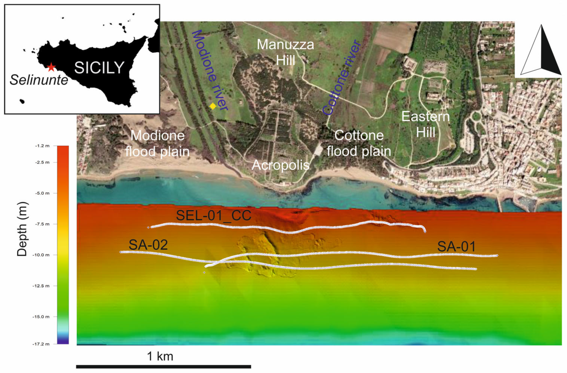
Selinunte (Selinus in Latin) was one of the most important Greek colonies in Sicily and is now the largest archaeological park in Europe (
Figure 1). The date of its foundation cannot be precisely determined. Historical dates range from 650 BC, as given by Diodorus, to 628 BC, as given by Thucydides. In 409 BC, the colony was sacked and completely destroyed by the Carthaginians. It was abandoned until Roman times and was only occasionally inhabited until about the 13th century CE. Despite its relatively short life span, the city acquired great military and economic importance, largely due to its strategic location in the central Mediterranean.
The promontory on which the acropolis of Selinunte was built is bordered by two rivers that today generally have a rather modest flow: the Modione (or Selinus) to the west and the Cottone (also known as Gorgo Cottone) to the east. These two rivers, straightened and partially channelized in the 1980s, now flow in delta-shaped plateaus that have been gradually filled by sediments.
In some cartographic representations of the colony of Selinunte, e.g., ref. [
2] two bays can be seen flanking the acropolis and coinciding with the present mouths of the rivers Modione and Cottone, which thus ran much further north in the past than they do today. Recent investigations carried out with a thermal imaging camera installed on a drone [
1] revealed a very similar palaeogeographic configuration of the area as the ancient representations, suggesting that the mouths of the rivers were much wider and the actual river valleys were occupied by the sea.
Archaeological excavations carried out in the past indicate the presence of port infrastructures related to the Modione and Cottone rivers [
3,
4], but their remains have not been verified and contextualized through comprehensive and systematic investigations [
3,
5]. Although there is currently no evidence for the existence of port infrastructures in the Modione River from the Greek period (the only known documentation is from the late Roman period, as described by [
4]), it is likely that Greek settlers used naturally sheltered areas at the mouth of the river [
6]. These sites were visible to travelers and explorers of the colony in the late 19th century [
7,
8], as they were occasionally exposed during winter and spring storms. Excavations carried out by Bovio Marconi in 1950–1951 and by the German Archeological Institute in 1995 revealed docks and moorings, but unfortunately, most of these finds are poorly documented in the literature, and all excavated areas have been backfilled.
Thanks to maps and plans of Sicily from the 12th to 17th centuries and based on traveler’s reports from the 16th to early 20th centuries, geographic features such as ponds and marshes near the colony have been documented, e.g., [
9]. Beginning in the mid-16th century and continuing for the past 500 years, the area has been described as a marshy, unhealthy environment that created conditions for the spread of disease and epidemics.
Palaeoenvironmental and palaeogeographic reconstructions based on an integrated analysis of archeological evidence, geological information, and the study of historical cartography and ancient written sources [
9,
10] show that the Cottone River was not a marshy and unhealthy intermittent river but a fully functioning water body with an active floodplain. Modern cartographers have demonstrated changes to the Modione River over the past 200 years, as shown by maps from 1782 to 1910, e.g., [
9], which document both meanders of the river and marshes.
Geophysical surveys, including seismic profiling with shear waves calibrated by drilling in both the Cottone and Modione river valleys [
11], have revealed the existence of two palaeo-valleys that underwent progressive sedimentation, leading to deltaic progradation with the emergence of a marsh and lagoon environment. In contrast, little is known about the coastal environment immediately offshore of the Selinunte archaeological park, with the exception of a high-resolution seismic survey from which a crude bathymetric map and a subsurface map were produced [
12].
In order to analyze the morphological characteristics of the seafloor and sedimentary environment in front of the archaeological park and to try to relate them to the information available on land, the results of a series of high-resolution seismic surveys and multibeam swath bathymetry are presented here. The main objective of these investigations is to try to reconstruct the palaeogeographic position of the two buried river valleys of Modione and Cottone and to analyze their sedimentary evolution. These valleys were formed by fluvial erosion in a continental environment when sea level was much lower than today during the Last Glacial Maximum (LGM) and were gradually filled with transitional and marine sediments.
In addition, this research may provide a basis for targeting future archaeological excavations, aiming to identify structures and facilities associated with the presence of harbors at the mouths of the two rivers of Selinunte.
2. General Morphological and Geological Environment
The study area, located on the southwestern coast of Sicily, is characterized by extensive, generally flat areas bordering hills that reach up to 250 m in the innermost parts. The archaeological park itself includes, from west to east: (i) a western hill (Gaggera Hill), (ii) the last part of the Modione valley, (iii) a central hill where the acropolis and the urban districts and agorà are located (Manuzza Hill), (iv) the flood plain of the Cottone river, and (v) the Eastern Hill, where is located the Temple of Zeus, one of the largest temples built by the Greeks in the Mediterranean. These three hills, on which the colony was built, are NS-oriented and have their tectonic origin in a horst-and-graben setting generated by Pleistocene normal faults trending NE-SW and NNW-SSE [
13]. Along the coastal plain, there is a series of marine terraces that reach heights of up to 170 m [
14,
15]. These landforms, sometimes covered by palaeosoils, are easily recognized due to the presence of numerous morphological steps. Mapping and luminescence aging of marine terraces and aeolian ridges yielded an estimated average uplift rate in the Selinunte area of 0.76 mm/year during the last 313 kyrs, with variability in the rates of ±0.2 to ±0.76 mm/year [
16]. Analysis of marine seismic reflection profiles recorded along the shelf area between Capo Granitola and Sciacca [
17] has shown that the growth rate of transpressional folds associated with the Capo Granitola and Sciacca strike-slip fault systems [
18,
19] halved from ~0.2 to 0.4 mm/year during the Pliocene and earliest Pleistocene to ~0.1 to 0.2 mm/year thereafter. High-resolution seismic profiles and bathymetric data [
20] indicate that the offshore area between Mazara del Vallo and Sciacca was uplifted by 0.6 mm/year after the LGM, a value consistent with the uplift rate estimated by Ferranti et al. [
16] for the late-middle to late Pleistocene. Sandy-silty alluvial deposits, locally terraced and ranging in age from late Pleistocene to Holocene, characterize the last section of the Modione and Cottone rivers. The coastal area is characterized instead by wide, predominantly sandy beaches, where coastal dunes run parallel to the coastline, and wetlands that are now partially or completely dry.
The area of the archeological park has been extensively studied from a geological point of view [
13,
21], and various geophysical survey methods have been applied to investigate the subsurface structural environment of the urbanized area (see BGTA Special Issue, vol. 34, 1992). The stratigraphic succession is largely characterized by Holocene deposits consisting of sand and alluvial deposits that fill the Modione and Cottone valleys, while the soils that form the surrounding hills on which the colony was built are composed of a yellow calcarenite formation interbedded with clayey sand with lenses of friable calcarenite and clay. This formation is very similar to the “Marsala calcarenite”, which consists of a marine sequence of different lithotypes (from calcarenite to clay) and was assigned to the early Pleistocene [
22]. In many areas of the hilltop, this calcarenite layer is highly altered and weathered, up to a thickness of 50 cm. According to these authors, the depositional environment of this sequence is circalittoral and transgressively overlies the late Pliocene–middle Pleistocene marly-arenaceous deposits of the “Belice” Formation [
23].
3. Materials and Methods
The original geophysical data presented in this paper comes from various surveys conducted between February 2016 and May 2023. Approximately 11 km of high-resolution seismic profiles were collected off the coast of the Selinunte archaeological park using a Boomer source consisting of an electrodynamic transducer mounted on a catamaran frame and a pre-amplified fixed streamer equipped with 10 hydrophones connected in series. Each hydrophone can be turned on and off, extending the active portion from 1 m to 10 m. During data collection, which was performed with a patrol boat at a speed of ~3 knots, the length of the active part of the streamer was kept lower than the water depth to avoid aliasing in the reflection signals since it is the sum of the array without Normal Move Out correction. The distance between the source and the streamer (offset) was 20 m. The firing rate of the plate (the unit energy delivered is 300 J/pulse) was 2 shots per second, and the reflected signal was sampled at 0.05 ms with a time window of 400 ms. The seismic data were tracked using a navigator connected to a differential GPS for accurate positioning. Data processing included: (i) DC-remove filter; (ii) gain recovery (a spherical divergence and amplitude recovery by inverting the amplitude decay curve); (iii) time-varying bandpass filters and 2D filters to remove electrical spikes; and (iv) predictive deconvolution designed on the seafloor to attenuate multiple reflections.
The multibeam swath bathymetric survey, covering an area of approximately 0.4 km
2, was conducted using a Baywei M5 portable sonar installed on a rented boat sailing at ~4 knots during the surveys. The system, equipped with an inertial system to detect vessel motion and heading, operates at a frequency of 400 kHz and illuminates a swath on the seafloor at 130° transverse and 0.5° longitudinal to the heading. To ensure optimal data collection, each individual swath was overlaid about halfway with the adjacent swath. A sound velocity probe profile was realized at the beginning and end of the survey to impose on the multibeam raw files the local sound velocity profile with depth. The acquired data were corrected for the following: (i) tidal excursions; (ii) application of automatic filters to remove spurious rays and improve the signal-to-noise ratio; and (iii) removal of residual spikes with a distance surface filter. Finally, a Digital Terrain Model (DTM) with a cell size of 0.5 × 0.5 m was created. To display the full bathymetric map of the Selinunte offshore area (see
Figure 1), information from the EMODNET portal (
https://emodnet.ec.europa.eu/en/bathymetry, accessed on 17 July 2023) was integrated to cover the areas where high-resolution multibeam data were not acquired.
4. Results
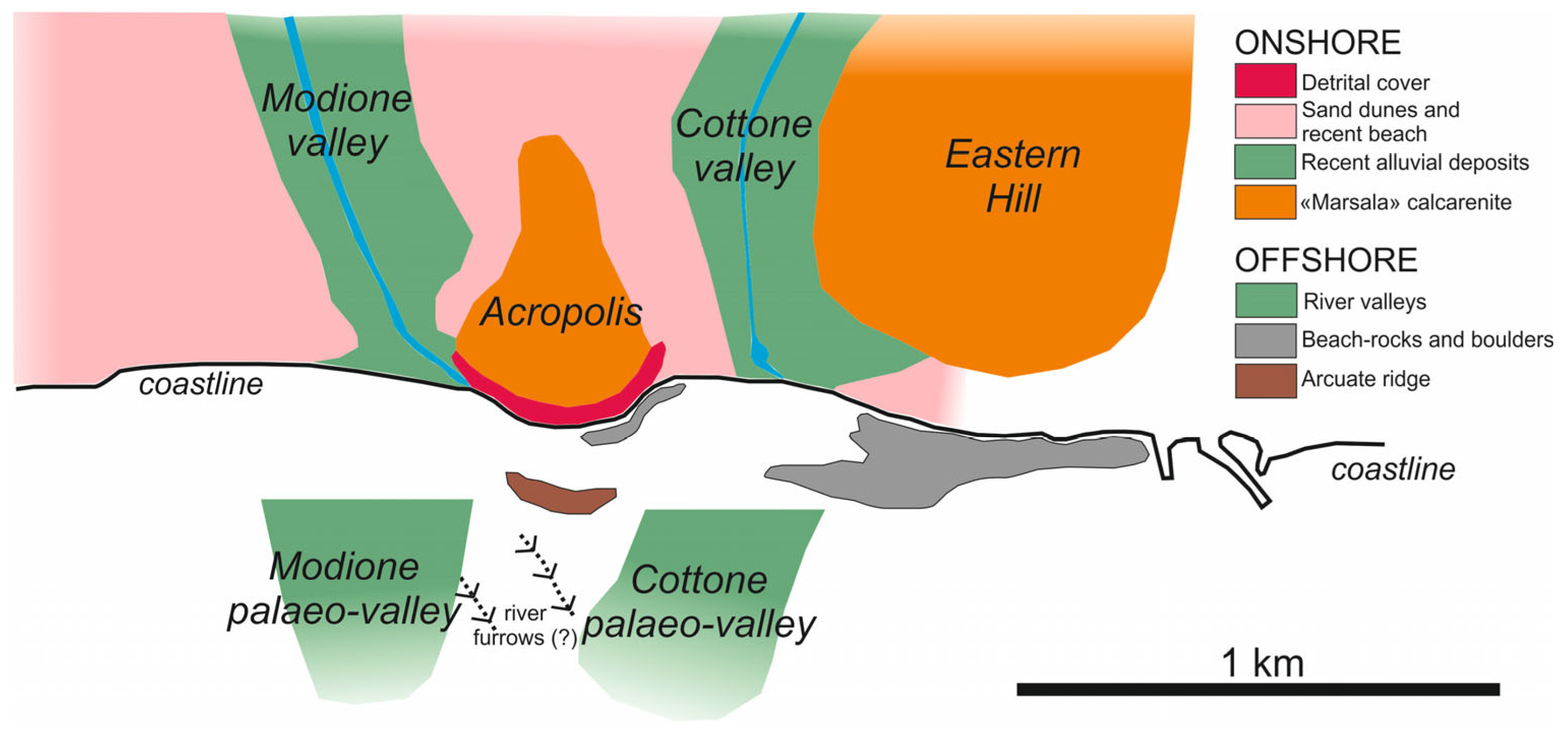
The coastal area covered by the bathymetric data includes, from west to east, the offshore parts of the alluvial plain and the mouth of the Modione River, the promontory on which the acropolis of Selinunte stands, and the alluvial plain and the mouth of the Cottone River. The water depth is 13.5 m at about 800 m from the coast (see
Figure 1), while near the coast, for safety reasons and because of the presence of various sectors of exposed rocks and detrital cover, the surveys were carried out to a minimum water depth of 1.4 m. The general slope of this stretch of coast towards the sea varies between 1.5% and 1.7%, being slightly more pronounced in the eastern part. It must be emphasized that only part of the area shown in
Figure 1 was surveyed using multibeam technology. Therefore, the remaining bathymetric information about the Selinunte coast was obtained from EMODNET maps in order to fully cover the area shown. However, some important geomorphological elements were identified from the high-resolution bathymetric data. These include the presence of two parallel V-shaped, N150° trending incisions approximately 10 m wide and 0.6 m deep, and 174 m (eastern incision) and 130 m (western incision) long. These features could be due to a local fluvial erosion process by an arm of the Modione River, although it is difficult to explain the hydrological regime that produced them. Another morphological element that can be inferred from the multibeam echo sounder data is the presence of an arcuate ridge at a depth of 1.6 m, which is about 12 m wide and has a slope of 5% towards the sea. It is located 150 m from the present coastline, immediately south of the promontory on which the acropolis stands. It is possible that this is an inherited morphology along the seaward slope of the promontory that was later modeled by wave action when the coastline reached this elevation (i.e., an overstepped, drowned, and not fully eroded cliff). Both the multibeam data and Google Earth satellite imagery show several areas characterized by detrital deposits and subsurface rocks, particularly in the eastern part of the study area. Some of them can be recognized as segments of beach rocks.
The three high-resolution seismic profiles presented here were acquired parallel to the coastline at distances between 210 and 420 m. The northernmost profile (SEL-01_CC) crosses from west to east the Modione floodplain, the offshore extension of the Selinunte promontory, and the Cottone floodplain (
Figure 2). The seafloor is horizontal and quite flat, except for the eastern end, where the line crosses a coarse belt of beach rocks and sparse boulders, also visible on the multibeam map. In the western part of the seismic section, there is a highly visible acoustic horizon at 19 ms TWT (two-way travel time), which is less discernible in the eastern part, where it flattens out at about 15 ms TWT. At an acoustic interval velocity of 1600 m/s (average value for water-saturated, poorly consolidated sand and clay sediment layers), the depth of this horizon is 15.2 and 12 m, respectively. It could represent the youngest Pleistocene and Holocene fluvial and coastal deposits that fill this part of the coastal area where the two rivers Modione and Cottone flow.
On the high-resolution seismic profile, two palaeo-valleys are visible, representing the ancient river valleys of the Modione (to the west) and the Cottone (to the east). They are 460 and 340 m wide and have a depth of 7.4 and 5.4 m, respectively, in their central part. Along this line, the acoustic signature of the buried top of the promontory of Selinunte can also be seen. In the eastern half of the profile, a high-amplitude sub-horizontal reflector is clearly visible at about 55 ms TWT, progressively curving and deepening toward the west and then gradually disappearing. This may represent the top of the “Belice” Formation described in this coastal sector of SW Sicily, composed mainly of marly-arenaceous sediments [
23]. We can roughly estimate that the top depth of this formation is 55 m if we assume an acoustic interval velocity of 2000 m/s. The seismic profile SA-01 (
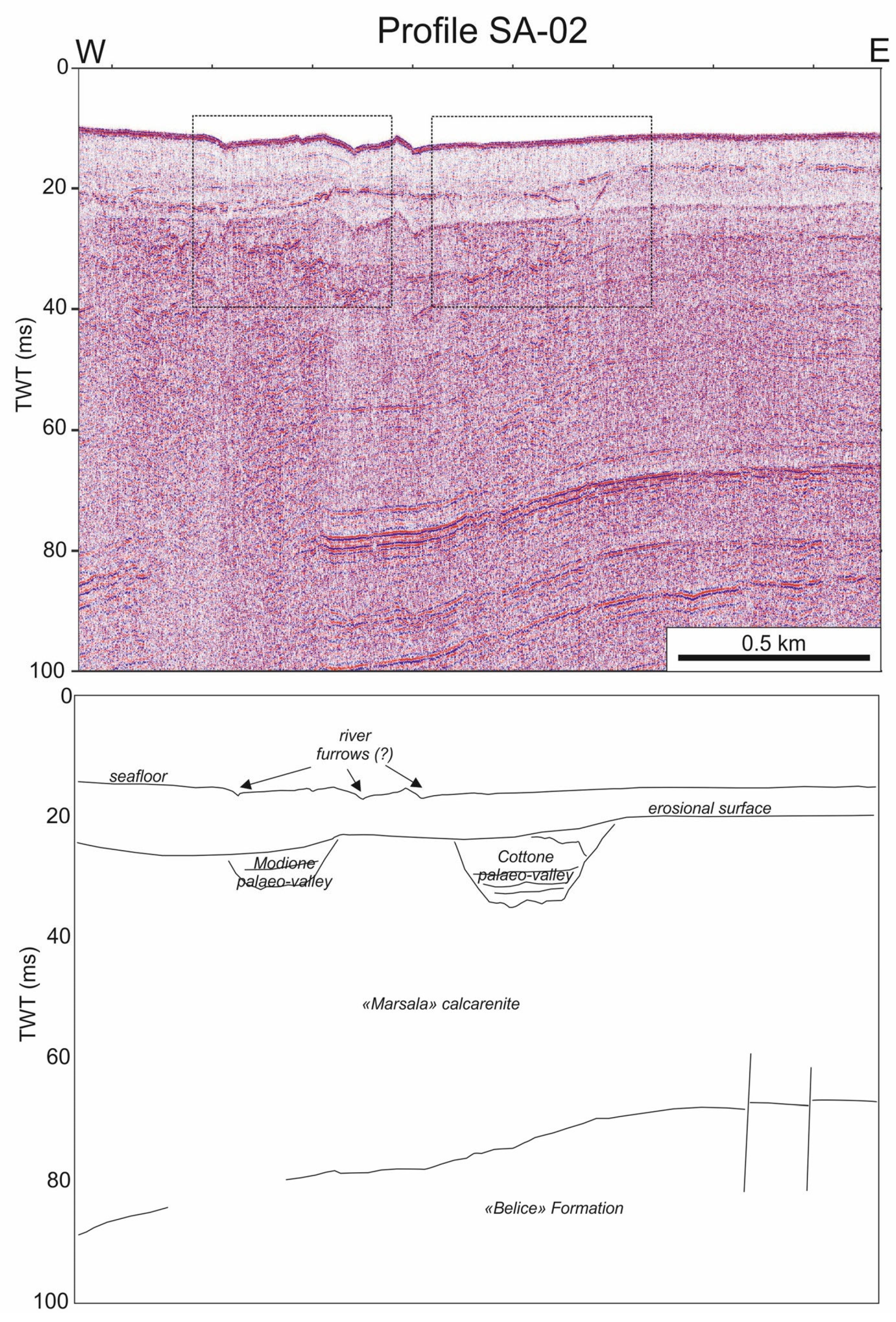
Figure 3), located 380 m offshore, crosses part of the Modione palaeo-valley and the whole Cottone palaeo-valley, which here is 360 m wide and 8 m deep. Along this profile, the reflector sub-parallel to the seafloor is also clearly visible, as is the high-amplitude horizon located at about 55 ms TWT in the eastern part of the line and dipping slightly to the west. This seismic profile crosses the two morphological elements described above—the fluvial incisions—which clearly represent a sedimentary feature since structures related to faults or/and buried strata are not visible. The outermost high-resolution seismic line SA-02 (
Figure 4) shows very similar features to the previous profiles. Here, the two palaeo-valleys of the Modione and Cottone rivers are 340 and 420 m wide and 6.4 and 9.6 m deep, respectively. The acoustic horizon, located in the eastern part of the profile at 66 ms TWT, deepens slightly to the west, where it gradually disappears.
In summary, the interpretation of the offshore seismic data has allowed the mapping of the following: (i) two important seismic markers at depths of about 15 and 55 m; and (ii) the two buried palaeo-valleys of the Modione and Cottone rivers, which show significant differences in width and depth, at least in the studied area (
Figure 5).
While the width of the Modione palaeo-valley gradually decreases toward the south, as does its depth, the Cottone palaeo-valley becomes wider and deeper toward the south. This is a particular morphological aspect that could be related to the different hydraulic characteristics of the two rivers in terms of water flow, the different surface geometry and distribution of their streams in their respective floodplain valleys (i.e., surface drainage network), and the different extent of their drainage basins.
5. Discussion
As briefly mentioned in the introduction, one of the most important aspects that is still unclear regarding the environment and urban organization of the colony of Selinunte in the past is the presence or absence of ancient port infrastructures at the mouths of the rivers Modione and Cottone. There is also little information about the topographic features of the valleys and the location and extent of the ancient courses of the two rivers flowing along the flanks of the colony. Some information about the palaeogeography of the area comes from historical documents, maps, or travel reports, e.g., [
9], and is supplemented by the results of archaeological excavations and geological and geophysical surveys. Two stratigraphic drillings reaching a depth of 15 m in the valleys of the Modione and Cottone rivers have shown that they are very different from each other [
11], with the western valley characterized by a quite uniform fluvial sedimentation and the eastern one showing the characteristics of a former lagoon connected to the sea. These authors assume that this lagoon was already silted up on its shore at the time of the establishment of the colony of Selinunte. This interpretation is consistent with the results of trench excavations in the Cottone valley [
24,
25,
26,
27], which made it possible to partially reconstruct the sedimentation history of this river valley shortly before the construction of the Greek defenses. A layer located directly beneath the fortifications can be interpreted as alluvial deposit, suggesting that the Cottone valley was a coastal alluvial plain, at least in its central section. It cannot be ruled out that such an alluvial plain was partially occupied by a lagoon that gradually silted up at the time of Greek settlement. Possibly the Cottone had a small outlet, and its floodplain was regularly inundated. From the middle of the 6th century BC to the end of the 5th century BC, the floods reached the fortifications and were stopped by them. After the end of the 5th century BC, no more floods were documented at the fortifications. In general, it has been suggested [
9] that the continued accumulation of sediment and low maintenance of the coastal floodplain may have contributed to the progressive silting of the river. Archaeological evidence shows that agriculture continued in the Selinunte area after 409 BC [
4], and although agriculture was not as intensive as in the Greek period, it contributed to the drying up of the Cottone River. Stratigraphic data suggests that seasonal flooding partially covered the floodplain, and these layers were left in place; in some areas, they were covered by roads/paving to restore the area. However, archaeological finds of canals or other forms of flooding systems has not yet been found. If they were built of stone, they may have been quarried and the stones reused elsewhere or have not yet been discovered. Another possibility is that they were built of organic material, which is difficult to find in the archaeological record of Selinunte.
In order to draw a palaeogeographic picture, albeit qualitative, of the study area and to attempt to correlate the information obtained on land with the offshore data presented in this paper, especially those derived from high-resolution seismic lines, we can use the results of a well (
Figure 6) drilled in the Modione valley about a hundred meters from the hydrographic left of the river and about 400 m from the present shoreline [
1].
Stratigraphic analysis has shown that at least 25 m of sediments of probable Holocene age have transitioned from a purely marine to a marshy environment to colluvial deposits, proving that the mouth of the Modione was originally an estuary of considerable depth. At about 25 m in the stratigraphic column, there is evidence of an erosional surface separating the Holocene succession above from an early Pleistocene clayey sedimentary layer below. Given the information from the high-resolution seismic profiles crossing the Modione riverbed just offshore, it can be inferred that the erosional contact visible in the stratigraphic well may represent the horizon sealing the river valley. This has been interpreted as the seafloor of 4500 years ago [
1], although no direct dating is available to determine the age of this discontinuity. In addition, no stratigraphic information is available to correlate this erosional horizon to the east in the Cottone valley where an erosional surface is visible at about the same depth (see
Figure 7). It should be emphasized that a few kilometers east of the study area, along the coast of Sciacca, an erosive surface was found at a depth comparable to that of the seismic profiles off Selinunte. In some cases this surface seals ancient river beds [
28].
The Modione riverbed has a series of sub-parallel reflectors that probably represent a succession of flood episodes that gradually filled the riverbed (
Figure 7A). In contrast, the Cottone riverbed exhibits more articulated geometry. Only in the lower part are the sub-parallel levels clearly visible, indicating different flooding phases, while in the upper part, the acoustic configuration is more complex. Some chaotic sediment bodies are seen, which could be due to the effect of a network of meandering streams. At the eastern edge of the riverbed, a V-shaped channel is clearly visible, indicating one of the last erosional phases of the river (
Figure 7B). This suggests that the configuration of the last section of the Cottone River was distinctly different from the Modione River, at least until the development of the erosional surface seen on the seismic profiles that essentially closed off the two river valleys. This, in turn, would indicate a more dynamic flow regime compared to the Modione River, with significantly larger volumes of water and therefore more suitable for navigation. What makes this interpretation even more incomplete is the lack of temporal calibration, since at this point, we can only rely on indirect correlations with analyses derived largely from palaeoenvironmental reconstructions of the area. In particular, with the data available to us, we do not know when the process of progressive siltation of the river delta actually began and rendered the coastal bay unusable as a harbor.
This information is important for an appropriate orientation of the excavation programs in the archeological field, in particular for the identification of harbor structures near the entrances of the two bays, which today are completely covered by the sediments of the rivers (
Figure 8).
As already emphasized, no elements that can be attributed to port infrastructures of the Greek period were found in the Modione valley, while some finds were documented photographically in the Cottone valley. Geophysical surveys revealed the traces of a road that had already been partially excavated, as well as evidence of the presence of large rectangular structures that, due to their size and location, could be attributed to the ancient port. Finally, geological investigations revealed the presence of marine deposits at a depth of 4.6 m. Geomagnetic surveys in the Cottone valley revealed several buried linear anomalies interpreted as structures of the ancient port of Selinunte [
29]. In August 2019 and 2020, a team led by Jon Albers (University of Bonn and Ruhr-University Bochum) excavated these anomalies. The results of these investigations have not yet been published. It would be interesting to understand if these walls can be related to the parallel walls known in the literature, to port structures, or the channelization of the Cottone river outflow, e.g., [
9].
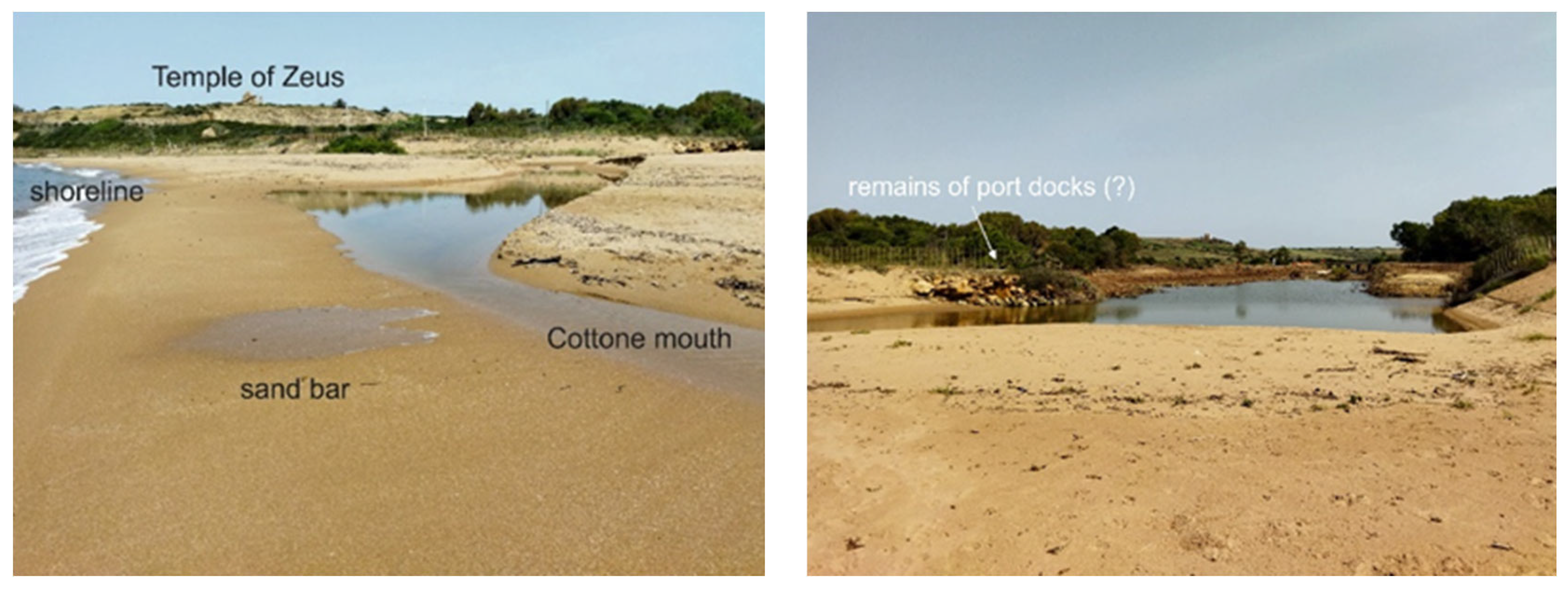
It should be recalled that in December 2019, after a strong storm, possibly associated with an exceptional low tide, blocks of the ancient port wharf on the Cottone River at the foot of the acropolis reappeared on the shore (see photo in
Figure 8) (
https://www.castelvetranoselinunte.it/tornati-alla-luce-the-remains-of-the-old-port-of-selinunte/127851/, accessed on 21 June 2023). This suggests that the extension of ancient port infrastructure and docks towards the coast goes far beyond the sites excavated in the 1950s, where important elements related to docks and anchor bollards were found. There is no doubt that the tectonic uplift phenomena documented in this coastal section allowed the exposure of these important remains, albeit as a result of an extreme meteorological event.
As seen in these cases, extreme weather events can resurrect archaeological elements that have been buried for millennia and for which there may have been no documentary evidence. For example, in the photograph in
Figure 8, one can see a sequence of square and overlapping blocks along the edge of the small lagoon formed after a severe flood near the mouth of the Cottone River. The energy of the current has dug deep on this side of the river and brought to the surface these structures, which it can be assumed could be the remains of harbor docks. There is no doubt that such episodes have occurred countless times in the past, and it is likely that the ancient inhabitants of Selinunte carried out important protection, containment, and drainage measures to prevent the siltation of the offshore bays and to preserve the harbor structures.
While revising this article, we came across the news spread by many local media on 16 July 2023, that at the mouth of the Cottone River, about a hundred meters from the present shoreline, a 15 m long structure was accidentally discovered, consisting of four rows of blocks about 1.80 m high. At present, archeologists have no definitive theories about the original form and function of this find, but they suspect that it may have been a retaining element on the river or the walls of a boat dock.
6. Conclusions
A new high-resolution bathymetric mapping and some seismic profiles recorded parallel to the coastal section where the Greek colony of Selinunte was built have made it possible to reconstruct the morphological environment and the stratigraphic setting of the beds of the two rivers that border the colony: the Modione to the west and the Cotton to the east.
This is the first time that marine geophysical data have been obtained in the immediate vicinity of the archeological park, where historical documents, some results of previous excavations, and remote sensing data suggest the presence of two bays used as harbors in ancient times and corresponding to the river valleys that exist today. The riverbeds identified offshore were formed by fluvial erosion in a continental environment when the sea level was much lower than today. After the LGM, the onset of marine transgression gradually filled the river valleys with transitional sediments (if preserved) and then with marine sediments. The lack of temporal calibrations does not allow a detailed reconstruction of the palaeogeographic evolution of these river valleys before and during the Selinunte period. However, the presence of a stratigraphic well in the Modione river valley has made it possible to attempt a correlation with the acoustic reflectors seen on the high-resolution seismic lines acquired offshore.
The information obtained in this work can be used for future archeological excavations in the park of Selinunte, also in view of the recent indications of emerging structures related to the presence of an ancient harbor near the mouth of the Cottone River. It is the task of archeological research to bring these traces of the past to light.


 ,
, 


