Article

Vegetation Composition in a Typical Mediterranean Setting (Gulf of Corinth, Greece) during Successive Quaternary Climatic Cycles

by
Aikaterini Kafetzidou
1,
Eugenia Fatourou
1,
Konstantinos Panagiotopoulos
1,2,
Fabienne Marret
3 and
Katerina Kouli
1,*
1
Department of Geology and Geoenvironment, School of Science, National and Kapodistrian University of Athens, Panepistimiopolis, 15784 Zographou, Greece
2
Institute of Geology and Mineralogy, University of Cologne, Zülpicher Straße 49a, 50674 Cologne, Germany
3
School of Environmental Sciences, University of Liverpool, Liverpool L69 7ZT, UK
*
Author to whom correspondence should be addressed.
Quaternary 2023, 6(2), 30; https://doi.org/10.3390/quat6020030
Submission received: 27 March 2023 / Revised: 21 April 2023 / Accepted: 24 April 2023 / Published: 5 May 2023

Abstract

:
The Gulf of Corinth is a semi-isolated basin in central Greece interrupting the Pindus Mountain Range, which nowadays is a biodiversity hotspot. Considering its key location, deep drilling was carried out within the International Ocean Discovery Program (IODP; Expedition 381: Corinth Active Rift Development) aiming to improve our understanding of climatic and environmental evolution in the region. Here, we present a new long pollen record from a Mediterranean setting in the southernmost tip of the Balkan Peninsula recording the vegetation succession within the Quaternary. The Corinth pollen record shows no major shifts in arboreal pollen between glacial and interglacial intervals, while Mediterranean and mesophilous taxa remain abundant throughout the study interval. During interglacials, the most frequent reconstructed biomes are cool mixed evergreen needleleaf (CMIX) and deciduous broadleaf forests (DBWB), while graminoid with forb (GRAM) and xerophytic shrubs (XSHB) dominate within glacials. Our findings support the hypothesis that the study area was a significant refugium, providing suitable habitats for Mediterranean, mesophilous and montane trees during successive Quaternary climate cycles.

1. Introduction

The study of pollen records from southern Europe has long been acknowledged as fundamental for the reconstruction of past terrestrial environmental changes, being the only quantitative proxy that provides continuous and accurate records of vegetation changes over the Quaternary glacial–interglacial cycles (e.g., [1,2,3,4]). There is consensus that the Quaternary vegetation dynamics of the north-eastern Mediterranean region were alternations between steppe/grassland and deciduous/evergreen forests occurring as a response to glacial–interglacial climatic cycles (e.g., [5,6,7,8,9]). However, climate-driven shifts in vegetation composition and distribution may vary significantly between sites due to the diverse local topography, which is especially pronounced in the Balkan Peninsula. For instance, in the Lake Ohrid pollen record, several arboreal taxa are present, even during glacial intervals (e.g., [10]), while at Tenaghi Philippon, they often disappear and only spread again within interglacials [6,11]. This spatial heterogeneity and proximity to other biogeographical regions (i.e., Asia Minor) produced a mosaic of habitats suitable for a wide range of plants and resulted in a remarkable high floristic diversity (e.g., [12,13,14,15]).
High-resolution pollen records from the southern Balkans suggest that the amplitude and timing of millennial-scale oscillations in mesophilous tree abundances depend on the latitude and altitude of the study area as well as its proximity to mesophilous tree refugia. Long pollen records located in mid-altitudes, between 400 and 850 m above sea level (masl), across the northern Pindus Mountain Range such as the ~480 ka Ioannina (470 masl [16,17]), the ~100 ka Lake Prespa (849 masl [18]) and the ~1.400 ka ICDP Lake Ohrid (693 masl [7,10]) suggest the survival of mesophilous tree populations in the region during successive glacial cycles. However, pollen records from sites located in the plains such as the ~1.350 ka Tenaghi Philippon (45 masl [6,11]) and the ~500 ka Kopais (95 masl [9,19]) suggest a discontinuous presence of mesophilous trees during glacials in the lowlands. These findings point to a migration lag of mesophilous tree taxa into the study areas, most likely from mid-altitudes in their vicinity, while Mediterranean taxa, surprisingly, represent only a minor part of the vegetation composition. Moreover, it should be noted that both sites are located on the eastern side of the Pindus Mountain Range and, thus, are influenced by a rain shadow effect, which can also be observed nowadays [20,21]).
The Gulf of Corinth is situated in a key location at the southernmost tip of the Balkan Peninsula, characterized mainly by Mediterranean vegetation. The topography of the gulf allows the predominantly westerly winds to bring moisture across the eastern side of the Pindus Mountain Range. Moreover, the Gulf of Corinth is surrounded by high mountains with several peaks rising above 2000 masl that, at present, host remarkable biodiverse flora and possess the refugial properties of the study area [22]. Therefore, it is strategically located to investigate the Quaternary vegetation and climate dynamics of the southern Balkan Peninsula and to test the evolution of environmental gradients across long time scales and their impact on past vegetation shift in the region.
During the IODP Expedition 381: Corinth Active Rift Development, a deep drilling campaign carried out in 2018 retrieved the southernmost long palaeoenvironmental record from the Balkans to date. A major aim of the interdisciplinary science team was to clarify the palaeoenvironmental history of the basin in order to constrain the rifting processes in space and time, as well as the interaction of rift development and climate on surface processes and sediment fluxes [23]. Here, we report new palynological data at a millennial resolution from the longest core drilled during Expedition 381 in the Gulf of Corinth, recording the vegetation response to climate oscillations of the Quaternary.

2. Materials and Methods

The site M0078, drilled during the IODP Exp. 381, is located in the central part of the Gulf of Corinth (38°8′41.802″ N 22°45′30.251″ E) at a water depth of 859.5 m (Figure 1). A synrift sedimentary sequence of a total length of 610.43 m below sea floor (mbsf) was retrieved (Figure 2), with two main lithostratigraphic units (LU) and several subunits [24]. Deposition within the upper unit, LU1 (0–385.14 mbsf), is primarily controlled by eustatic sea level and is dominated by detrital clay- and silt-grade carbonate, arranged in 11 different facies associations (FA). The lithologic, micropaleontological and physical properties of this unit (LU1) record periodic alternations of marine and isolated/semi-isolated intervals and allowed the identification of 16 subunits (LU1.1–1.16 [23]). Lithostratigraphic unit 2 (LU2) is mainly composed of weakly laminated to homogeneous highly bioturbated mud (FA12). The boundary between LU1 and LU2, at 385.14 mbsf, is evidenced by an abrupt shift from laminated greenish gray muds to homogeneous light gray muds [23].

2.1. Chronology

The chronological framework of the deposits is based on magnetostratigraphy and on stratigraphic correlation with absolute dated deposits of the neighbouring IODP 381 site M0079. The Brunhes/Matuyama boundary (MBB, 773 ka [27]) of M0078 has been recorded at the depth of 386 mbsf, close to the boundary between LU1 and LU2 ([23]). In addition, the proposed occurrence of the Jaramillo Subchron (1000–1080 ka) between 519.32 and 574.72 mbsf provides further independent chronostratigraphic points [23]. Further age control points using coccolithophore assemblages are limited only to high-stand (interglacial) intervals when the basin was connected to the Mediterranean Sea [23]. Therefore, the last occurrence of Pseudoemiliania lacunosa recorded at 298.6 mbsf is most likely not the true last appearance (LAD) at 430 ka [28] as it is recorded during the lowstand MIS 12, when the Gulf of Corinth was isolated from the Mediterranean Sea [23]. Additional age constraints are obtained through stratigraphic correlation with the neighboring site M0079, while the age–depth model is based on magnetostratigraphy and palaeointensity data [29], as well as several Th/U absolute datings [26]. Gawthorpe et al. [26] recognized three types of stratal packages (bioturbated, laminated and bedded), which allowed a new detailed stratigraphic subdivision of lithostratigraphic unit 1, leading to a new high-resolution correlation of stratal packages between sites M0078 and M0079, both originating from the central of the Gulf of Corinth, from MIS 1–13 (Figure 2).
Figure 2. Site M0078: lithostratigraphic units (LUs), facies associations (FA) and Brunes/Matuyama boundary (MBB) after [23]. Total samples analyzed (in red) and samples included in the analysis (in black). Stratal packages and correlation with MIS after [26]. FA1: homogenous mud, FA2: greenish gray mud with dark gray to black silty-to-sandy beds (cm-scale), FA3: light gray to white sub-mm laminations (cc or aragonite) alternating with mud–silt beds, FA4: laminated greenish gray to gray mud with muddy beds, FA5: greenish gray mud with homogeneous cm thick gray mud beds, FA6: green bedded partly bioturbated mud, silt and sand, FA10: interbedded mud/silt and dm thick sand beds, FA11: interbedded mud/silt and cm thick sand beds, FA12: light gray to buff, homogenous to weakly stratified mud. Stratal packages: bedded: deposition during glacial periods; bioturbated: deposition during interglacial periods and laminated: deposition during the transitions between glacial and interglacial periods.
Quaternary 06 00030 g002

2.2. Palynology and Biome Reconstruction

Sampling of the M0078 core for palynological analyses was carried out at the Bremen Core Repository at the University of Bremen, Bremen, Germany. For the present study, a total of one hundred seventy-four (174) samples (Figure 2) were chemically treated. The upper (LU1; 384.3–0 mbsf) and the lower part (LU2; 610–385 mbsf) of the sequence comprise 112 and 62 samples, respectively. For palynological analysis, approximately three grams of dry sediment were chemically treated using the laboratory protocol developed during IODP Exp. 381 [23]. Preparation of the samples included the use of hot hydrochloric acid (HCl 37%), cold hydrofluoric acid (HF 38%) and sieving through a 10 μm sieve. To calculate the concentration of palynomorphs in each sample, one Lycopodium tablet was added at the beginning of the treatment. Residues were mounted in glycerine, while microscopic analysis was conducted under a transmitted light Zeiss Axiolab 5 microscope at magnifications of ×400 and ×1000. Out of the 174 samples analyzed, only 141 are included in the present study as they yielded sufficient pollen content. In these samples, a mean of 400 terrestrial pollen grains were counted. Samples containing fewer than 100 terrestrial pollen grains, excluding Pinus, were omitted from the present study. Terrestrial pollen percentages were calculated based on a pollen sum of all terrestrial pollen excluding Pinus as a result of its overrepresentation in a large number of samples. Oak pollens were classified into three types according to their morphological characteristics, following [30]: Quercus robur-type (deciduous oaks), Quercus ilex-type (evergreen oaks) and Quercus cerris-type (semi-deciduous oaks). Further identifications follow [31,32,33,34,35]. Asteraceae comprise Cirsium- and Senecio-types. Pollen taxa were classified into ecogroups following [13].
Pollen diagrams were plotted using the Tilia program [36]. Pollen assemblage zones were determined with the help of constrained incremental sums of squares (CONISS) cluster analysis for all terrestrial pollen taxa with percentages above 2% [36]. Given the millennial temporal resolution of the diagram and the forthcoming high-resolution studies, we assigned Corinth vegetation superzones (CVSZ 1–9 sensu [5]) that roughly correspond to major vegetation shifts. This approach allows for the definition of new pollen zones and subzones within these superzones once the high-resolution data from the Gulf of Corinth archive become available. The biomization technique developed by Prentice et al. [37] was applied to reconstruct the biome distribution in the Gulf of Corinth record. Pollen taxa were arranged into plant functional types (PFTs) and biomes that represent major vegetation types [37,38]. The biome–taxa matrix of Marinova et al. [39] that was developed for the Eastern Mediterranean–Black Sea–Caspian corridor (EMBSeC) has been used. Identified pollen taxa were assigned to twenty-six plant functional types and to thirteen biomes as defined for the region [39]. We ran the analysis in two different matrices including all terrestrial pollen, one with and one without pines due to their overrepresentation in the pollen record. In the analysis including Pinus, although the data matrix was square-rooted in order to increase the method sensitivity and stability, Pinus appeared to mask other vegetation types [39]. Hence, here we present the reconstructed biomes based on the data of the matrix excluding Pinus.

3. Results

The pollen assemblages are characterized by high concentrations of terrestrial pollen during interglacial intervals with concentrations exceeding 51,370 grain g−1 and a minimum of 127 grains g−1, while during glacial intervals concentrations are significantly low (max: 5221 grain g−1; min: 143 grain g−1). The pollen diversity is generally high, and almost 100 different pollen taxa were identified (Table S1). Mesophilous and Mediterranean taxa dominate the pollen assemblages, reaching up to 55% and 48%, respectively. Relatively poor preservation and/or low pollen concentration were recorded in the two intervals 370–580 mbsf and 207–237 mbsf. Therefore, several samples were excluded from this study. Selected pollen taxa are presented in the two main palynological diagrams (Figure 3 and Figure 4), and the main vegetation features are summarized in Table 1.

4. Discussion

4.1. Vegetation and Climatic Inferences

In the pollen record from the Gulf of Corinth, Mediterranean and mesophilous taxa percentages co-dominate the interglacial pollen assemblages, whereas herbaceous (steppic) percentages dominate within glacial intervals (Figure 3 and Figure 4). High arboreal pollen percentages and concentrations, more evident in the Mediterranean trees, characterize the pollen assemblages in CVSZ-7, CVSZ-5 and CVSZ-3, suggesting forested intervals. These superzones generally represent warmer and wetter climatic conditions corresponding to interglacial intervals.
Intervals characterized by higher non-arboreal pollen (NAP) percentages, when Poaceae and steppic taxa dominate the assemblage, suggest the occurrence of rather open vegetation, such as grasslands or steppe communities, in the surroundings of the gulf. Within these intervals, the persistence of Mediterranean taxa implies that this group remains a significant component of the vegetation. Similarly, the continuous presence of mesophilous and montane tree populations (e.g., CVSZ-6 and CVSZ-4) at favorable locations within the catchment is suggested by the related taxa abundances. These findings can be tentatively associated with rather cold and dry climatic conditions corresponding to glacial intervals and vertical zonation of vegetation surrounding the gulf.

4.1.1. CVSZ-9

Within CVSZ-9, the resolution of the pollen samples is rather low due to relatively poor preservation and/or low pollen sums. NAP percentages reach values up to 83% at the base of this interval (514.66–574.72 mbsf). High Cichorieae and Pinus percentages (up to 38% and 70%, respectively) imply a possible shift in the deposition conditions and could be traced back to significant sea level changes occurring within the basin. A profound maximum of montane trees (mostly Cedrus: 51%) at the depth of 479.76 mbsf, along with a concurrent minimum of Mediterranean percentages (2%), is recorded. The occurrence of mesophilous, montane and Mediterranean taxa within this interval suggests the presence of distinct vertical zonations of vegetation. However, these zonation does not yet appear to be established, as observed in the absolute maximum montane and minimum Mediterranean percentages occurring within this interval.
Figure 3. Pollen percentage diagram of selected terrestrial taxa plotted against depth (exaggeration ×10). Lithostratigraphic units (LUs [23]), pollen assemblage superzones (CVSZs) and CONISS are shown.
Quaternary 06 00030 g003
Maxima of NAP (80%) and an increase in mesophilous tree percentages are recorded in the uppermost part of this superzone. The inferred vegetation of CVSZ-9 seems quite mixed, which could be partly attributed to the relatively low number of samples with good preservation and a sufficient pollen sum available. Transitions between open grassland vegetation and increased forest cover are observed in the assemblages, as well as in the reconstructed biomes (Figure 4). Based on the age constraints of the deposits, this interval can be tentatively correlated to the interval MIS 19 to MIS 28 [26].
Figure 4. Gulf of Corinth pollen percentage diagram of ecogroups, AP + NAP concentration (excl. Pinus) (×10 grains g−1); AP concentration in dark green and NAP in gray. Ecological groups: montane trees (Abies, Cedrus, Fagus, Betula and Taxus); mesophilous trees (Q. robur-type, Q. cerris-type, Carpinus betulus, Ostrya/Carpinus-type, Corylus, Castanea, Tilia, Ulmus, Buxus, Hedera); Mediterranean trees (Q. ilex-type, Olea, Phillyrea, Pistacia, Sorbus); riparian trees (Alnus, Salix); steppic taxa (Artemisia, Chenopodiaceae, Ephedra distacya, Ephedra fragilis). Lithostratigraphic units (LUs [23]), pollen assemblage superzones (CVSZs), reconstructed biomes and CONISS are shown.
Quaternary 06 00030 g004
The most frequent reconstructed biomes within the study interval are graminoids with forbs (GRAM), cool mixed evergreen needle leaf and deciduous broadleaf forest (CMIX), xeric shrubland (XSHB) and deciduous broadleaf woodland (BDWD). GRAM is the most frequent reconstructed biome (62 samples; encountered in all superzones, CVSZ-1 to CVSZ-9), followed by CMIX (38 samples; CVSZ-1 to CVSZ-9), XSHB (24 samples; CVSZ-2, CVSZ-3, CVSZ-5, CVSZ-6, CVSZ-8, CVSZ-9) and DBWD (14 samples; CVSZ-1, CVSZ-4, CVSZ-5, CVSZ-7, CVSZ-8, CVSZ-9). In addition, two samples were assigned to the warm–temperate evergreen sclerophyll broadleaf shrubland (WTSHB: two samples; CVSZ-4, CVSZ-7) and one sample to the temperate deciduous malacophyll broadleaf forest (TEDE:1 sample; CVSZ-9).

4.1.2. CVSZ-8

Pollen assemblages in CVSZ-8 present significant AP fluctuations (23–67%), expressing the alternation of periods characterized by the dominance of Mediterranean and mesophilous taxa and intervals when steppic elements reach their maximum percentages. Intervals of maximum percentages of Chenopodiaceae (26%), Artemisia (8%), Cichorieae (18%), Asteraceae (14%) and Poaceae (19%) are interrupted by the abrupt increase in trees (e.g., Q. robur-type max: 40%, Q. ilex-type max: 30%). These vegetation shifts are also traced in the reconstructed biomes that show alternations between steppe (GRAM and XSHB) and forested (CMIX and DBWD) communities. Out of 40 samples analyzed in total within this superzone, only 15 samples contained a sufficient number of pollen grains and were, therefore, included in the pollen diagrams. Despite poor pollen preservation and relatively low sampling resolution, these vegetation changes are most likely associated with shifts occurring in the depositional environment during successive glacial–interglacial intervals.
Three distinct AP percentages and concentration peaks occur at 365.51 mbsf, 328.51 mbsf and 288.06 mbsf within LUs 1.15, 1.13 and 1.11, respectively (Figure 4), correlating with intervals during which marine transgration occurred the Gulf of Corinth [26,40]. The first one has the lowest AP concentration (1281 grains g−1) and percentages (45%), while the second has the maximum AP abundance (33,852 grains g−1, 69%) within CVSZ-8. Finally, AP abundances appear to stabilize in the third peak (7863 grains g−1, 60%). Mediterranean percentages increase towards the top of the superzone, reaching their maximum values (30%) within LU1.11. Mesophilous taxa reach a maximum of 39% at 328.51 mbsf within LU1.13 and stabilize around 24% within the upper part.
The first expansion of arboreal vegetation (mostly sclerophyllous species) within this interval (LU1.15) suggests interglacial climate conditions, and can be tentatively correlated with MIS 17 or MIS 15, considering the occurrence of the Brunhes/Matuyama boundary at the depth of 386 mbsf (LU1.16 [23]). A similar pattern is observed in the upper part of CVSZ-8 within LU1.13 and LU1.11. The expansion of Mediterranean and mesophilous vegetation suggests the occurrence of warmer and wetter conditions. Based on the lithostratigraphic correlation with the site M0079 [26], these intervals correspond to MIS 13 and MIS 11, respectively.
In LUs 1.14, 1.12 and 1.10, which represent lowstand intervals during which the Gulf of Corinth was isolated from the Mediterranean [23], the AP concentration is significantly low, while several samples were barren. Prominent peaks in steppic taxa as well as lower AP concentrations and percentages within these glacial intervals suggest colder and drier climatic conditions. The most well-defined of all, recorded in six samples, is the AP minimum within LU1.12, which is suggested to correlate with the MIS 12 [26]. This interval presents minima in AP concentration (83 grains g−1), but moderate AP percentages (42%) associated mainly with the maxima of montane taxa (e.g., Abies 18%). This expansion is most probably the result of a migration of the montane vegetation zone to lower altitude areas, suggesting the occurrence of suitable habitats for their survival during MIS 12.
Similarly, pollen assemblages from Lake Ohrid during this interval demonstrate a reduction in AP percentages in two stages (Figure 5), where forest contractions and expansions were recorded [41], suggesting that the MIS 12 glacial phase was cold but wet [7]. These events are similar to the short-term forest expansions recorded in southern Europe during the Last Glacial, both in composition and in duration [42]. In the Balkan Peninsula, for example, the Tenaghi Philippon pollen record shows that the most extreme tree population declines occurred during the glacial maxima of MIS 12, where the lowest AP percentages of all glacial intervals were recorded [11]. A cold but somehow wet MIS 12 is also suggested by the expansion of the mountain glaciers in Greece during MIS 12 and MIS 6, the most extensive glacial phase in the Greek mountains since the Middle Pleistocene [20,43,44].

4.1.3. CVSZ-7

CVSZ-7 is characterized by higher AP percentages compared to the previous interval, reaching a maximum of 70%. The Mediterranean and mesophilous taxa co-dominate and present two distinct peaks throughout the superzone. The first tree expansion (258.17 mbsf) comprises the maximum Mediterranean (36%) and mesophilous (22%) percentages. In the second AP peak (237.75 mbsf), mesophilous and Mediterranean taxa (30% and 26%, respectively) co-dominate, suggesting higher and/or more even moisture in the catchment. This is also reflected in the reconstructed biomes, which show a shift from Mediterranean shrubland (WTSHB and GRAM) to cool mixed forests (CMIX). According to the stratigraphical correlation, LU1.9 corresponds to MIS 9 [26]. It should be noted that despite a total of 18 samples analyzed, only 4 yielded sufficient pollen content. This poor palynomorph preservation could be associated with a concurrent shift in the depositional environment in the basin. Considering the low resolution of the pollen record, the double AP peak pattern of this interval might be tentatively correlated with other regional pollen records (e.g., Ioannina [45] and Tenaghi Philippon [46]) and Turkey (lake Van [47]), where a three-phase mesophilous tree expansion is interrupted by two marked peaks of steppe communities. Therefore, the two distinct AP peaks in this low-resolution interval might be a partial expression of the recorded climatic variability within MIS 9.

4.1.4. CVSZ-6

In CVSZ-6, NAP percentages increase in comparison to the previous interval, reaching a maximum of 72%. This NAP peak comprises mostly grasses (Poaceae 28%) and steppic taxa such as Chenopodiaceae (18%), Cichorieae (14%) and Artemisia (10%). The significant drop in AP concentration (mean: 211 grains g−1) in comparison to CVSZ-7, the very low evergreen oak percentages (4%) and the maximum of steppic percentages (33%) point to colder and drier conditions within this interval. The graminoid with forb (GRAM) and xeric shrubland (XSHB) biomes reconstructed during this period also suggest the occurrence of glacial climatic conditions. Based on the stratigraphic correlation with site M0079, sediments within LU1.8 were deposited within MIS 8 [26]. During this period, the Gulf of Corinth appears to be isolated from the Mediterranean Sea based on sedimentological, geochemical and dinoflagellate results [23,40].
Although the vegetation composition suggests the prevalence of glacial conditions, significant mesophilous trees (mean: 16.2%) persist in the catchment throughout this interval. A moderate expansion of mesophilous and montane trees (max: 28 and 10%, respectively) at the upper part of this interval, combined with the decreasing steppic taxa percentages and the maximum values of Poaceae (28%), implies an increase in moisture. High Poaceae percentages are mainly ascribed to extensive grasslands that are typical for rather open landscapes occurring in glacial periods (e.g., [6,48]), whereas a concurrent Cyperaceae peak could also indicate an increase in run-off and the occurrence of wetlands in the borderlands of the gulf. These findings point to a rather open landscape and the colonization of newly exposed land by herbaceous species, such as Chenopods, following this marine regression phase.
This shift in the vegetation composition within MIS 8 is also demonstrated in the reconstructed biomes, which show a transition from herbaceous (meadow) vegetation (GRAM and XSHB) to a more meadow–forest vegetation type (CMIX and GRAMM). These findings point to a more humid late MIS 8, which is in agreement with other regional pollen records (Figure 5). In the Lake Ohrid record, mesophilous percentages increase within MIS 8, although they do not exceed 10% [10], while the Tenaghi Philippon record shows a shift from steppic to forest–steppe communities [46]. The complex topography of the Gulf of Corinth catchment most likely allowed the vertical migration of species and the parallel occurrence of all major vegetation zones. The east–west direction of the gulf and the prevalence of moist westerly winds could also account for the persistence of a significant mesophilous vegetation component in the borderlands of the gulf.

4.1.5. CVSZ-5

CVSZ-5, expanding in LUs 1.7, 1.6 and 1.5, presents higher mean NAP percentages compared to the previous interval; however, they fluctuate (max: 91% and min: 31%). These fluctuations are mainly recorded in the maximum values of Artemisia (14%), Chenopodiaceae (16%), Asteraceae (15%) and Cichorieae (19%). At the same time, trees and shrubs present three distinct expansion phases, evidenced both in their percentages and concentrations, corresponding to favorable climatic intervals. Based on the sedimentological correlations, this interval corresponds to the MIS 7 interglacial complex [26].
The lowermost (213.55 mbsf) AP expansion (AP concentration 765 grains g−1) presents the highest values of Mediterranean trees (40%), the minimum mesophilous percentages (8%) and the absence of montane taxa, implying warmer climatic conditions, but increased summer aridity. Within the second phase (202.04 mbsf), maxima of AP concentration as well mesophilous and montane taxa (2018 grains g−1, 20% and 8%, respectively) are evidenced, while Mediterranean trees remain abundant (35%), suggesting an increase in moisture availability. At the uppermost (186.95 mbsf) AP expansion, the AP concentration is again lower (1000 grain g−1), mesophilous elements remain stable (19%) and a minor increase in Mediterranean is observed (38%), while montane taxa are almost absent (<2%). This three-step tree expansion is disrupted by two intervals (205 and 197–190 mbsf) of profound steppic vegetation expansion, corresponding to periods with deteriorated climatic conditions (stadials). Within the lower interval (205 mbsf), the minimum values of Mediterranean trees (6%) combined with the maximum values of Cichorieae and, surprisingly, mesophilous taxa (19% and 35%, respectively) indicate a period with decreased temperatures but with relative humidity. The reduction in AP concentration (108 grains g−1) supports the notion of forest openness. A more steppe-like environment with maximum of Artemisia (14%), Chenopodiaceae (16%), Asteraceae (15%) and Poaceae (52%) is observed within the following interval (197–190 mbsf). The decrease in mesophilous (min: 6%) and the short-lived expansion of montane taxa (max: 17%), combined with the increasing trend of steppic taxa (max: 25%), attest to a drop in temperature and a decrease in moisture availability during this stadial interval. Τhe recorded abrupt maxima of Poaceae (>50%) most probably feature the expansion of the Phragmites lacustrine vegetation belt around the Gulf of Corinth during the temporal sea lowstand recorded in LU1.6 [23,40].
The vegetation shifts observed within the MIS 7 interglacial complex are also evident in the reconstructed biomes. A transition from herbaceous vegetation (GRAM) to cool mixed evergreen and deciduous broadleaf woodland (CMIX and DBWD) indicates the climatic oscillations occurring within CVSZ-5. The response of vegetation during this interval differs from that of MIS 9 and MIS 11. In particular, evergreen oaks present higher abundances than deciduous oaks, suggesting the occurrence of warmer and increased seasonality than during previous interglacial intervals. In the Lake Ohrid pollen record, this interglacial/interstadial complex is characterized by three-step alternations of a co-occurrence of montane and mesophilous taxa with two steppe vegetation expansions [7]. In our record, the forest expansion phases are mainly represented by the Mediterranean trees; however, mesophilous trees appear to be less abundant in this southern Mediterranean site. However, similarly to other western Balkan sites, they persist during the open vegetation expansion intervals (Ioannina: [49]; Lake Ohrid: [7]), while at the eastern site of Tenaghi Philippon, mesophilous tree populations almost disappear during the stadial intervals [5]. Finally, in both Lake Ohrid and the Gulf of Corinth records, maximum values of Artemisia indicating arid conditions are observed during the later stadial of the MIS 7 complex [7].
Figure 5. Comparison of selected ecogroups from Tenaghi Philippon and Lake Ohrid spanning the 1.4 Ma with the Gulf of Corinth. Tenaghi Philippon: AP % excluding Pinus, Betula and Juniperus [11]; Lake Ohrid: AP % (excl. Pinus), sclerophilous trees, mesophilous trees [10]; Gulf of Corinth (plotted against depth): arboreal pollen (AP excl. Pinus), Mediterranean, steppic and mesophilous trees (see Section 3 for details), pollen concentration (excl. Pinus) and pollen assemblage superzones (CVSZs).
Quaternary 06 00030 g005

4.1.6. Zone CVSZ-4

During CVSZ-4, an increase in NAP percentages mainly recorded in the maximum percentages of Artemisia (9%), Chenopodiaceae (14%), Asteraceae (33%) and Cichorieae (27%) is evidenced, implying a deterioration in the climatic conditions. AP concentrations drop to 472 grains g−1, while their abundances exhibit sharp fluctuations (20–92%). These fluctuations are mainly pronounced in Mediterranean taxa (min: 6%), which reach abundances of even 39% (max), while the mesophilous taxa display a lower range (min: 4%; max: 29%). Riparian taxa exhibit their maxima percentages throughout the entire record (14%). Based on sedimentological description of LU1.6, this interval corresponds to MIS 6 [26], presenting the vegetation composition during a glacial phase. During CVSZ-4, the most frequent reconstructed biome is graminoid with forb (GRAM). A striking feature of this phase is Cedrus, which appears in significantly higher percentages (max: 10%) compared to other regional records [10,11].
In the lower part (177.59–150.12 mbsf), maxima in the Poaceae (36%), Cyperaceae (13%) and riparian taxa (14%) suggest increased run-off. Mesophilous taxa percentages show a gradual decline upwards, and their values decrease from 30% to approximately 5% at a depth of 150.12 mbsf to stabilise around 14%. In the upper part of CVSZ-4, Mediterranean trees and Artemisia reach their maxima (39% and 10%, respectively), which, combined with decreasing mesophilous percentages, imply a decrease in moisture availability in the catchment. This vegetation shift is also evidenced in the reconstructed biomes, which show a transition from cool mixed forests (CMIX) to herbaceous vegetation (GRAM) upcore.
These findings point to a more humid early MIS 6, which is in agreement with other regional records. A cold but wet MIS 6 is also suggested by the expansion of the mountain glaciers in Greece, as during MIS 6 and MIS 12, the most extensive glacial phases in the Greek mountains since the Middle Pleistocene were recorded [20,43,44]. Pollen records from the northern Pindus Mountain Range record a shift from grasslands to steppic communities (Lake Ohrid [7]) and a decrease in mesophilous percentages during MIS 6 (Ioannina [17]). In contrast to these archives, AP values remain above 20% throughout this interval within the Gulf of Corinth. This suggests that the surroundings of the gulf provided suitable habitats for the survival of montane, mesophilous and Mediterranean tree species during MIS 6

4.1.7. CVSZ-3

CVSZ-3 is characterized by the highest, though fluctuating, AP abundances up to 85%, featuring an interval with ameliorated but unstable climatic conditions. At the lower part of the superzone, the pollen data disclose an interval marked by three Mediterranean tree expansions with maximum pollen concentrations alternated with an expansion of mesophilous tree taxa and a forest openness phase upcore, respectively. Based on the age constraints of the deposits and the sedimentological description of LU1.3, the lower part of CVSZ-3 could tentatively correspond to the Last Interglacial Complex [26].
The lower part (112.71–91.62 mbsf) of CVSZ-3 is characterized by the highest AP concentration (maxima of 26,835 grains g−1) and sharp peaks in Mediterranean (max 48%) and mesophilous (max 33%) tree abundances, implying the occurrence of interglacial conditions. Three minor retreats of Mediterranean taxa are evidenced at 108.75 mbsf, 101.86 mbsf and 97.45 mbsf: the two coinciding with a major increase in mesophilous and montane taxa (29%) and the intermediate one with the short expansion of steppe communities (28%) with Artemisia (19%). These sharp shifts represent expansions and retreats of Mediterranean and mesophilous vegetation during the Last Interglacial Complex, with the peaks of montane and steppic elements characterizing the intervals of climatic deterioration. These vegetation shifts are also evidenced in the reconstructed biomes, which show a transition from cool mixed forests (CMIX) to herbaceous vegetation (GRAM and XSHB). During the interstadials of the MIS 5 complex, the vegetation composition of regional pollen records from the southern Balkans (e.g., Tenaghi Philippon [50] and Lake Ohrid [7,51]) presents the dominance of mesophilous communities in the assemblage. In contrast to these archives, where Mediterranean taxa never exceed percentages of 15%, in the Gulf of Corinth pollen record, they prevail and remain abundant even during stadials as a result of the catchment area location and topography.
Upwards, within the lower part of LU1.2 (91.62–80.24 mbsf), an increase in NAP percentages, mainly recorded in the maximum values of Artemisia (24%), Chenopodiaceae (15%), Asteraceae (15%) and Poaceae (36%) and a minimum in AP concentration (690 grains g−1), is evidenced. In addition, this features periods with deteriorated climatic conditions during the Last Glacial interval. Mediterranean taxa, mainly Q. ilex-type, present significantly lower values, compared to the previous interval, featuring the occurrence of deteriorated climatic conditions during the Last Glacial interval. In parallel, the maximum Poaceae percentages (36%) might represent the colonization of emerging areas during this lowstand interval. Following this, an expansion of mesophilous tree percentages (55%), featuring a maximum in the Q. cerris-type, combined with the decreased steppic abundances suggest a temporal expansion of the forest cover.
The top of CVSZ-3 (71.34–65.7 mbsf) records the rebound of Mediterranean and steppic taxa along with the decrease in mesophilous trees, suggesting the occurrence of a warmer period with decreased moisture availability. The vegetation shifts within the upper part of CVSZ-3 are also evident in the reconstructed biomes, which show a transition from herbaceous and xerophytic vegetation (GRAM and XSHB) to cool mixed forests (CMIX) and an extensive open vegetation (GRAM) upcore.
Despite the recorded vegetation fluctuations within this upper part of CVSZ-3, the resilience of mesophilous and Mediterranean trees in the borderlands of the Gulf of Corinth should be highlighted. This could be assigned to the southern location of the site and the topography, which allows the vertical migration of vegetation belts. The persistence of mesophilous taxa, even during glacial intervals, is also recorded in both Lake Ohrid [7,10] and Lake Ioannina pollen records [17], in contrast to the Tenaghi Philippon archive [11]. Finally, an interesting feature is the Cedrus fluctuations. This taxon appears in higher abundances (max: ~4%) within this Last Glacial interval, compared to the Lake Ohrid pollen record [10], in which it presents extremely low values (~1%). Overall, in the catchment of the Gulf of Corinth, Cedrus presents its maxima within glacial intervals, while in other records from the northern Pindus Mountain Range, the maximum percentages are evidenced during interglacial phases. This could likely be assigned to the southern position and the more humid climatic regime of the site, which allowed this summer drought-tolerant species to expand in snow-fed favorable habitats of the montane zone during glacials.

4.1.8. CVSZ-2

During CVSZ-2, the AP percentages show a slight decrease; however, they prevail over NAP, reaching a maximum of 68%. The AP decrease is, however, clearly evidenced in the AP concentration (mean: 445 grains g−1). Maximum percentages of Artemisia (24%) Chenopodiaceae (19%) and Cichorieae (27%) demonstrate the expansion of the herbaceous (steppic) vegetation within the upper part of LU1.2 that corresponds partly to the Last Glacial interval [26,40] (Figure 3 and Figure 4).
The synchronous major drop in Mediterranean vegetation (min: 3%) is also indicative of the unfavorable climatic conditions that are also demonstrated by the dominance of the xeric shrubland (XSHB) biome. In the lower part of this interval (62.67–50.44 mbsf), maxima in Artemisia (24%) and Ephedra spp. (6%) and a gradual decline in mesophilous taxa percentages from 45% to 13% at a depth of 50.44 mbsf are recorded, suggesting the apparent opening of the landscape and the predominance of dry conditions. The sharp decrease in AP percentages and concentration (min: 32% and 118 grains g−1, respectively) observed at a depth of 50.44 mbsf most likely demonstrate the vegetation response to the Last Glacial maximum. Furthermore, a sharp increase in montane taxa (max: 33%) and a major drop in Mediterranean taxa (min: 3%) indicate the occurrence of cool climatic conditions that pushed the tree line, shifting the montane zone towards lower altitudes. In parallel, the maximum percentages of Salix (3%) could probably suggest increased run-off.
At the upper part of CVSZ-2, an expanding trend of mesophilous and Mediterranean trees, reaching a maximum of 49% and 26%, respectively, an increase in AP concentration (mean: 460 grain g−1) and increased abundances of herbaceous vegetation (max: 37%) are observed. The reconstructed biomes also feature the transition from steppe communities (GRAM) to cool mixed forests (CMIX) within this upper part of the Last Glacial interval. The gradual expansion of mesophilous taxa, reaching 49%, is an interesting characteristic of the Gulf of Corinth record in comparison to other regional archives. A similar vegetation signal has been recorded in Lake Kopais [9,19] and in the nearby Saronic Gulf, implying relatively wet and mild climatic conditions during the Late Glacial [52]. In contrast, the northern records, along the Pindus Mountains, present either lower mesophilous taxa percentages (e.g., Lake Ioannina [16] and Lake Ohrid [7]) or the spread of pines, in some higher-altitude catchments such as Xinias, Lakes Orestias and Prespa, Edessa [53,54,55,56]. These findings suggest that the surroundings of the gulf provided suitable habitats for the survival of mesophilous taxa within the Last Glacial interval, confirming the regional climatic/ecological gradients along the Balkan Peninsula [17].

4.1.9. CVSZ-1

CVSZ-1 is characterized by high AP percentages (max: 73%) at the base, which gradually decrease upwards, presenting a minimum of 33%. The lower part represents the expansion of deciduous oaks (47%) at the onset of the Holocene in response to the climatic ameliorations. Following this, the sharp increase in Mediterranean tree taxa (max: 38%) and a reduction in mesophilous trees attest to the temporal expansion of Mediterranean shrubland during warmer and drier climatic conditions. In the upper part, the retreat of both deciduous and evergreen woodland, along with the expansion of Cichorieae (max: 21%) and Chenopodiaceae (max: 10%), can be attributed to the increasing human activity in the borderlands of the Corinth Gulf since antiquity, as also reported in several onshore palaeovegetation studies (e.g., [57,58]) (Figure 3). The low AP concentration (mean: 270 grains g−1) in the upper part could be assigned to the high sediment influx in the basin [23] during the Holocene. The regeneration of Mediterranean tree taxa, leading to the development of the present-day landscape dominated by maquis vegetation, is attested at the uppermost part of the studied sequence.

4.2. Comparison with Regional Pollen Records

Comparison of the Gulf of Corinth with other long continuous sequences from the southern Balkan Peninsula, such as Kopais, Ioannina, Tenaghi Philippon or Lake Ohrid [7,8,9,11,17,59,60], showed that, despite certain differences, a correlation scheme among the pollen records could be assumed. The main similarity with Lake Ohrid is that arboreal pollen is continuously present in both sites, even during glacial intervals, while in other records of the Balkan Peninsula, such as Tenaghi Philippon or Kopais [9,11], they often disappear and only occur during interglacials [17] (Figure 5). The vegetation at Tenaghi Philippon seems to have reacted in a more sensitive way to the climatic cycles, possibly due to the reduction in temperature and moisture [51]. Quite a different situation is found at Ioannina (western Greece), a site characterized as a refugium for mesophilous trees, featuring sub-Mediterranean vegetation and climate during the last ∼480 ka [17,59,60]. Similarly, the survival of several mesophilous trees is recorded within the catchment of Lake Prespa during the Last Glacial [18]. It has already been proposed that mid-altitude sites were more suitable for maintaining refugial populations of mesophilous trees because of orographic precipitation [61]. The study of pollen records from different bioclimatic areas in Greece presented in [17] exhibited the significance of local topography and ecological factors in controlling the vegetation response to climate variation. Topography controls the occurrence and the availability of local microenvironments, in variable altitudes, to which populations can accommodate in response to climate changes. Both temperature and CO2 concentration are known to increase with decreasing altitude. Vertical migration allows plant populations, at least in part, to avoid extirpation, by providing sufficient topographic variability to supply a range of microhabitats suitable for survival [17]. On a regional scale, the Gulf of Corinth pollen record presents the greatest similarities to the Lake Ohrid pollen record [7,10]; however, some very intriguing differences are reported. The Lake Ohrid record shows the sensitive response of vegetation to Quaternary climate variation, while in the Corinth pollen record, no major vegetation shifts are observed between glacials/interglacials. Mesophilous trees are dominant in Lake Ohrid [7,10]; however, Mediterranean trees appear to be the main vegetation component in the Gulf of Corinth, in high percentages both in glacial and interglacial intervals. They are more resilient to the climate fluctuations, possibly due to their lowland distribution and their ability to withstand aridity. In addition, mesophilous trees were significant components both in the glacial and interglacial vegetations (20%).
In the Gulf of Corinth pollen record, the Mediterranean trees represent the vegetation composition during interglacials, while the steppic maxima represent the vegetation during glacials, in contrast to the typical AP/NAP glacial/interglacial pattern. The response of vegetation in the borderlands of the Corinth Gulf to climatic variability appears more complex due to the southern location of the site and the topography allowing the vertical migration of vegetation belts. Long pollen records located in mid-altitudes (between 400 and 850 m above sea level) across the Pindus Mountain Range, such as the Ioannina, Prespa and Ohrid records, suggest the survival of mesophilous trees during glacial intervals cycles [7,16,17,18]. In contrast, the Gulf of Corinth basin is surrounded by an extensive range of altitudes (0–2000 masl), allowing a wide spectrum of shifts in vegetation, resulting in plant survival during glacials. Finally, the sharp fluctuations observed in the tree pollen percentages in the Gulf of Corinth record have also been reported for the last climatic cycle in the southern Kopais, and most likely relate to the quick expansion of proximal refugial populations [19].
Finally, the persistence of Cedrus in the Gulf of Corinth record is noteworthy. Previous palaeobotanical studies across the northern Mediterranean region report the gradual retreat and disappearance of this subtropical species during the Early Pleistocene (e.g., [62,63]), while in southern Italy, they most likely persisted till MIS 13 [64,65]. The gradual extinction of Cedrus across the main three northern Mediterranean peninsulas has been assigned mainly to climate oscillations, catchment properties and biogeographical and ecological traits of the plant itself (e.g., [66,67]). In the Balkan Peninsula, Cedrus becomes extinct in the Tenaghi Philippon pollen record in the Early–-Middle Pleistocene Transition [11]. In Lake Ohrid, Cedrus appears in low abundances throughout MIS 8–5, while in Gulf of Corinth, it exhibits a nearly continuous curve up to the Last Glacial interval. In addition, the major peak of Cedrus (>40%) in Gulf of Corinth, recorded in CVSZ-9, is significantly higher than its abundances observed in Lake Ohrid during the same intervals, while percentages above 30% have only been recorded during MIS 37 and MIS 39 [10,13]. High abundances of Cedrus (>20%) are also recorded in the pollen spectra of Tsampika microbasin (Rhodes), within the MIS 17 and MIS 18 [68]. The persistence of Cedrus in the borderlands of the Gulf of Corinth could be attributed to the local topography and the occurrence of a milder microclimate favoring the plants’ survival.

5. Conclusions

The sedimentary archive from the Gulf of Corinth is the first long palaeoenvironmental record retrieved from the southernmost tip of the Balkan Peninsula, and provides a unique opportunity to reconstruct the terrestrial biodiversity and its response to climatic variability throughout the Quaternary. In the pollen record from the Gulf of Corinth, Mediterranean trees represent the vegetation composition during interglacials, while the steppic maxima represent the vegetation during glacials, in contrast to the typical AP/NAP glacial/interglacial pattern. Mediterranean sclerophyllous vegetation is among the most striking features of the assemblages, while mesophilous taxa are represented in lower abundances and open vegetation is a significant component of the pollen assemblage throughout the entire record. The persistence of Mediterranean and mesophilous vegetation during glacials presents the refugial character of the Gulf of Corinth. The complex topography of the Gulf of Corinth, with a high range of altitudes, and the large size of the basin catchment provide space for the vertical migration of the vegetation zones in the Gulf of Corinth borderlands. Comparison with other long pollen records of the Balkan Peninsula presented some similarities; however, significant differences are also reported.

Supplementary Materials

The following supporting information can be downloaded at: https://www.mdpi.com/article/10.3390/quat6020030/s1, Table S1: List of the detailed pollen taxa.

Author Contributions

Conceptualization: K.K., K.P. and F.M.; Investigation: A.K., E.F., K.K., K.P. and F.M.; Validation: A.K. and K.K.; Writing—Original Draft: A.K. and E.F.; Writing—Review and Editing: K.K., A.K., E.F., K.P. and F.M.; Supervision: K.K. and K.P.; Project Administration and Funding Acquisition: K.K. All authors have read and agreed to the published version of the manuscript.

Funding

This research was supported by the Hellenic Foundation of Research and Innovation (H.F.R.I) under the “First Call for H.F.R.I. Research Projects to support Faculty members and Researchers and the procurement of high-cost research equipment grant” (Project Number: 1026, Quaternary Environmental Changes in the Corinth Rift Area: the IODP 381 palynological record: QECCoRA).

Institutional Review Board Statement

Not applicable.

Informed Consent Statement

Not applicable.

Data Availability Statement

The data presented in this study are available on request from the corresponding author.

Acknowledgments

The study material was retrieved during IODP Exp. 381. The authors would like to express their sincere thanks to all the members of the SP, ECORD Science Operator staff, D/V Fugro Synergy crew and the staff of MARUM for their contribution to the successful completion of the expedition. The authors are thankful to the reviewers for their positive and constructive comments.

Conflicts of Interest

The authors declare no conflict of interest.

References

  1. Tzedakis, P.C.; Andrieu, V.; De Beaulieu, J.L.; Crowhurst, S.; Follieri, M.; Hooghiemstra, H.; Magri, D.; Reille, M.; Sadori, L.; Shackleton, N.J.; et al. Comparison of terrestrial and marine records of changing climate of the last 500,000 years. Earth Planet. Sci. Lett. 1997, 150, 171–176. [Google Scholar] [CrossRef]
  2. Follieri, M.; Magri, D.; Sadori, L. Pollen stratigraphical synthesis from Valle di Castiglione (Roma). Quat. Int. 1989, 3–4, 81–84. [Google Scholar] [CrossRef]
  3. Sánchez Goñi, M.F.; Eynaud, F.; Turon, J.L.; Shackleton, N.J. High resolution palynological record off the Iberian margin: Direct land-sea correlation for the Last Interglacial complex. Earth Planet. Sci. Lett. 1999, 171, 123–137. [Google Scholar] [CrossRef]
  4. Reille, M.; De Beaulieu, J.-L.; Svobodova, H.; Andrieu-Ponel, V.; Goeury, C. Pollen analytical biostratigraphy of the last five climatic cycles from a long continental sequence from the Velay region (Massif Central, France). J. Quat. Sci. 2000, 15, 665–685. [Google Scholar] [CrossRef]
  5. Tzedakis, P.C. Hierarchical Biostratigraphical Classification of Long Pollen Sequences. J. Quat. Sci. 1994, 9, 257–259. [Google Scholar] [CrossRef]
  6. Pross, J.; Koutsodendris, A.; Christanis, K.; Fischer, T.; Fletcher, W.J.; Hardiman, M.; Kalaitzidis, S.; Knipping, M.; Kotthoff, U.; Milner, A.M.; et al. The 1.35-Ma-Long Terrestrial Climate Archive of Tenaghi Philippon, Northeastern Greece: Evolution, Exploration, and Perspectives for Future Research. Newsl. Stratigr. 2015, 48, 253–276. [Google Scholar] [CrossRef]
  7. Sadori, L.; Koutsodendris, A.; Panagiotopoulos, K.; Masi, A.; Bertini, A.; Combourieu-Nebout, N.; Francke, A.; Kouli, K.; Joannin, S.; Mercuri, A.M.; et al. Pollen-Based Paleoenvironmental and Paleoclimatic Change at Lake Ohrid (South-Eastern Europe) during the Past 500 Ka. Biogeosciences 2016, 13, 1423–1437. [Google Scholar] [CrossRef]
  8. Wijmstra, T.A. Palynology of the First 30 Metres of a 120 m Deep Section in Northern Greece. Acta Bot. Neerl. 1969, 18, 511–527. [Google Scholar] [CrossRef]
  9. Okuda, M.; Yasuda, Y.; Setoguchi, T. Middle to Late Pleistocene Vegetation History and Climatic Changes at Lake Kopais, Southeast Greece. Boreas 2001, 30, 73–82. [Google Scholar] [CrossRef]
  10. Donders, T.; Panagiotopoulos, K.; Koutsodendris, A.; Bertini, A.; Maria Mercuri, A.; Masi, A.; Combourieu-Nebout, N.; Joannin, S.; Kouli, K.; Kousis, I.; et al. 1.36 Million Years of Mediterranean Forest Refugium Dynamics in Response to Glacial-Interglacial Cycle Strength. Proc. Natl. Acad. Sci. USA 2021, 118, e2026111118. [Google Scholar] [CrossRef] [PubMed]
  11. Tzedakis, P.C.; Hooghiemstra, H.; Pälike, H. The Last 1.35 Million Years at Tenaghi Philippon: Revised Chronostratigraphy and Long-Term Vegetation Trends. Quat. Sci. Rev. 2006, 25, 3416–3430. [Google Scholar] [CrossRef]
  12. Tzedakis, P.C.; McManus, J.F.; Hooghiemstra, H.; Oppo, D.W.; Wijmstra, T.A. Comparison of changes in vegetation in northeast Greece with records of climate variability on orbital and suborbital frequencies over the last 450,000 years. Earth Planet. Sci. Lett. 2003, 212, 197–212. [Google Scholar] [CrossRef]
  13. Panagiotopoulos, K.; Holtvoeth, J.; Kouli, K.; Marinova, E.; Francke, A.; Cvetkoska, A.; Jovanovska, E.; Lacey, J.H.; Lyons, E.T.; Buckel, C.; et al. Insights into the evolution of the young Lake Ohrid ecosystem and vegetation succession from a southern European refugium during the Early Pleistocene. Quat. Sci. Rev. 2020, 227, 106044. [Google Scholar] [CrossRef]
  14. Petit, R.J.; Aguinagalde, I.; De Beaulieu, J.L.; Bittkau, C.; Brewer, S.; Cheddadi, R.; Ennos, R.; Fineschi, S.; Grivet, D.; Lascoux, M.; et al. Glacial refugia: Hotspots but not melting pots of genetic diversity. Science 2003, 300, 1563–1565. [Google Scholar] [CrossRef]
  15. Blonder, J.; Aronson, J.; Bodiou, J.Y.; Boeuf, G. The Mediterranean Region: Biological Diversity in Space and Time; Oxford University Press: Oxford, UK, 2010. [Google Scholar]
  16. Tzedakis, P.C.; Lawson, I.T.; Frogley, M.R.; Hewitt, G.M.; Preece, R.C. Buffered Tree Population Changes in a Quaternary Refugium: Evolutionary Implications. Science 2002, 297, 2044–2047. [Google Scholar] [CrossRef] [PubMed]
  17. Tzedakis, P.C.; Frogley, M.R.; Lawson, I.T.; Preece, R.C.; Cacho, I.; de Abreu, L. Ecological Thresholds and Patterns of Millennial-Scale Climate Variability: The Response of Vegetation in Greece during the Last Glacial Period. Geology 2004, 32, 109–112. [Google Scholar] [CrossRef]
  18. Panagiotopoulos, K.; Böhm, A.; Leng, M.J.; Wagner, B.; Schäbitz, F. Climate Variability over the Last 92 Ka in SW Balkans from Analysis of Sediments from Lake Prespa. Clim. Past 2014, 10, 643–660. [Google Scholar] [CrossRef]
  19. Tzedakis, P.C. The Last Climatic Cycle at Kopais, Central Greece. J. Geol. Soc. Lond. 1999, 156, 425–434. [Google Scholar] [CrossRef]
  20. Leontaritis, A.D.; Kouli, K.; Pavlopoulos, K. The Glacial History of Greece: A Comprehensive Review. Mediterr. Geosci. Rev. 2020, 2, 65–90. [Google Scholar] [CrossRef]
  21. Sindosi, O.A.; Bartzokas, A.; Kotroni, V.; Lagouvardos, K. Influence of Orography on Precipitation Amount and Distribution in NW Greece; A Case Study. Atmos. Res. 2015, 152, 105–122. [Google Scholar] [CrossRef]
  22. Trigas, P.; Tsiftsis, S.; Tsiripidis, I.; Iatrou, G. Distribution Patterns and Conservation Perspectives of the Endemic Flora of Peloponnese (Greece). Folia Geobot. 2012, 47, 421–439. [Google Scholar] [CrossRef]
  23. McNeill, L.C.; Shillington, D.J.; Carter, G.D.O.; Everest, J.D.; Le Ber, E.; Collier, R.E.L.; Cvetkoska, A.; De Gelder, G.; Diz, P.; Doan, M.-L.; et al. Corinth Active Rift Development. In Proceedings of the International Ocean Discovery Program; International Ocean Discovery Program: College Station, TX, USA, 2019; Volume 381. [Google Scholar] [CrossRef]
  24. Shillington, D.J.; McNeill, L.C.; Carter, G.D.O.; the Expedition 381 Participants. Expedition 381 Preliminary Report: Corinth Active Rift Development; International Ocean Discovery Program Preliminary Report; International Ocean Discovery Program: College Station, TX, USA, 2019. [Google Scholar] [CrossRef]
  25. McNeill, L.C.; Shillington, D.J.; Carter, G.D.O.; Everest, J.D.; Gawthorpe, R.L.; Miller, C.; Phillips, M.P.; Collier, R.E.L.; Cvetkoska, A.; de Gelder, G.; et al. High-Resolution Record Reveals Climate-Driven Environmental and Sedimentary Changes in an Active Rift. Sci. Rep. 2019, 9, 3116. [Google Scholar] [CrossRef] [PubMed]
  26. Gawthorpe, R.L.; Fabregas, N.; Pechlivanidou, S.; Ford, M.; Collier, R.E.L.; Carter, G.D.O.; McNeill, L.C.; Shillington, D.J. Late Quaternary Mud-Dominated, Basin-Floor Sedimentation of the Gulf of Corinth, Greece: Implications for Deep-Water Depositional Processes and Controls on Syn-Rift Sedimentation. Basin Res. 2022, 34, 1567–1600. [Google Scholar] [CrossRef]
  27. Singer, B.S. A Quaternary Geomagnetic Instability Time Scale. Quat. Geochronol. 2014, 21, 29–52. [Google Scholar] [CrossRef]
  28. Agnini, C.; Monechi, S.; Raffi, I. Calcareous Nannofossil Biostratigraphy: Historical Background and Application in Cenozoic Chronostratigraphy. Lethaia 2017, 50, 447–463. [Google Scholar] [CrossRef]
  29. Maffione, M.; Herrero-Bervera, E. A Relative Paleointensity (RPI)-Calibrated Age Model for the Corinth Syn-Rift Sequence at IODP Hole M0079A (Gulf of Corinth, Greece). Front. Earth Sci. 2022, 10, 813958. [Google Scholar] [CrossRef]
  30. Smit, A. A Scanning Electron Microscopical Study of the Pollen Morphology in the Genus Quercus. Acta Bot. Neerl. 1973, 22, 655–665. [Google Scholar] [CrossRef]
  31. Beug, H.J. Leitfaden der Pollenbestimmung für Mitteleuropa und Angrenzende Gebiete (Guide to the Pollen Analysis for Central Europe and the Adjacent Areas); Verlag Dr. Friedrich Pfeil: Munchen, Germany, 2004. [Google Scholar]
  32. Chester, P.I.; Raine, J.I. Pollen and Spore Keys for Quaternary Deposits in the Northern Pindos Mountains, Greece. Grana 2001, 40, 299–387. [Google Scholar] [CrossRef]
  33. Reille, M. Long Pleistocene Pollen Records from the Praclaux Crater, South-Central France. Quat. Res. 1995, 44, 205–215. [Google Scholar] [CrossRef]
  34. Reille, M.; Andrieu, V.R.; De Beaulieu, J.-L.; Guenet, P.; Goeury, C. A Long Pollen Record from Lac Du Bouchet, Massif Central, France: For the Period ca. 325 to 100 Ka BP (OIS 9c to OIS 5e). Quat. Sci. Rev. 1998, 17, 1107–1123. [Google Scholar] [CrossRef]
  35. Reille, M. New Pollen-analytical Researches in Corsica: The Problem of Quercus Ilex L. and Erica Arborea L., the Origin of Pinus Halepensis Miller Forests. New Phytol. 1992, 122, 359–378. [Google Scholar] [CrossRef] [PubMed]
  36. Grimm, E.C. CONISS: A FORTRAN 77 Program for Stratigraphically Constrained Cluster Analysis by the Method of Incremental Sum of Squares. Comput. Geosci. 1987, 13, 13–35. [Google Scholar] [CrossRef]
  37. Prentice, I.C.; Cramer, W.; Harrison, S.P.; Leemans, R.; Monserud, R.A.; Solomon, A.M. Special Paper: A Global Biome Model Based on Plant Physiology and Dominance, Soil Properties and Climate. Source J. Biogeogr. 1992, 19, 117–134. [Google Scholar] [CrossRef]
  38. Prentice, I.C.; Guiot, J.; Huntley, B.; Jolly, D.; Cheddadi, R. Reconstructing Biomes from Palaeoecological Data: A General Method and Its Application to European Pollen Data at 0 and 6 Ka. Clim. Dyn. 1996, 12, 185–194. [Google Scholar] [CrossRef]
  39. Marinova, E.; Harrison, S.P.; Bragg, F.; Connor, S.; de Laet, V.; Leroy, S.A.G.; Mudie, P.; Atanassova, J.; Bozilova, E.; Caner, H.; et al. Pollen-Derived Biomes in the Eastern Mediterranean–Black Sea–Caspian-Corridor. J. Biogeogr. 2018, 45, 484–499. [Google Scholar] [CrossRef]
  40. Fatourou, E.; Kafetzidou, A.; Marret, F.; Panagiotopoulos, K.; Kouli, K. Late Quaternary Ponto-Caspian dinoflagellate cyst assemblages from the Gulf of Corinth, Central Greece (eastern Mediterranean Sea). Mar. Micropaleontol. 2023, 179, 102211. [Google Scholar] [CrossRef]
  41. Koutsodendris, A.; Kousis, I.; Peyron, O.; Wagner, B.; Pross, J. The Marine Isotope Stage 12 pollen record from Lake Ohrid (SE Europe): Investigating short-term climate change under extreme glacial conditions. Quat. Sci. Rev. 2019, 221, 105873. [Google Scholar] [CrossRef]
  42. Fletcher, W.J.; Sánchez Goñi, M.F.; Allen, J.R.M.; Cheddadi, R.; Combourieu-Nebout, N.; Huntley, B.; Lawson, I.; Londeix, L.; Magri, D.; Margari, V.; et al. Millennial-scale variability during the last glacial in vegetation records from Europe. Quat. Sci. Rev. 2010, 29, 2839–2864. [Google Scholar] [CrossRef]
  43. Leontaritis, A.D.; Pavlopoulos, K.; Marrero, S.M.; Ribolini, A.; Hughes, P.D.; Spagnolo, M. Glaciations on ophiolite terrain in the North Pindus Mountains, Greece: New geomorphological insights and preliminary 36Cl exposure dating. Geomorphology 2022, 413, 108335. [Google Scholar] [CrossRef]
  44. Allard, J.L.; Hughes, P.D.; Woodward, J.C.; Fink, D.; Simon, K.; Wilcken, K.M. Late Pleistocene glaciers in Greece: A new 36Cl chronology. Quat. Sci. Rev. 2020, 245, 106528. [Google Scholar] [CrossRef]
  45. Roucoux, K.H.; Tzedakis, P.C.; de Abreu, L.; Shackleton, N.J. 24. Fine-tuning the land-ocean correlation for the late middle pleistocene of Southern Europe. Dev. Quat. Sci. 2007, 7, 359–373. [Google Scholar] [CrossRef]
  46. Fletcher, W.J.; Müller, U.C.; Koutsodendris, A.; Christanis, K.; Pross, J. A centennial-scale record of vegetation and climate variability from 312 to 240ka (Marine Isotope Stages 9c-a, 8 and 7e) from Tenaghi Philippon, NE Greece. Quat. Sci. Rev. 2013, 78, 108–125. [Google Scholar] [CrossRef]
  47. Litt, T.; Pickarski, N.; Heumann, G.; Stockhecke, M.; Tzedakis, P.C. A 600,000 year long continental pollen record from Lake Van, eastern Anatolia (Turkey). Quat. Sci. Rev. 2014, 1–12. [Google Scholar] [CrossRef]
  48. Tzedakis, P.C.; Andrieu, V.; de Beaulieu, J.L.; Birks, H.J.B.; Crowhurst, S.; Follieri, M.; Hooghiemstra, H.; Magri, D.; Reille, M.; Sadori, L.; et al. Establishing a terrestrial chronological framework as a basis for biostratigraphical comparisons. Quat. Sci. Rev. 2001, 20, 1583–1592. [Google Scholar] [CrossRef]
  49. Roucoux, K.H.; Tzedakis, P.C.; Frogley, M.R.; Lawson, I.T.; Preece, R.C. Vegetation history of the marine isotope stage 7 interglacial complex at Ioannina, NW Greece. Quat. Sci. Rev. 2008, 27, 1378–1395. [Google Scholar] [CrossRef]
  50. Milner, A.M.; Roucoux, K.H.; Collier, R.E.L.; Müller, U.C.; Pross, J.; Tzedakis, P.C. Vegetation responses to abrupt climatic changes during the Last Interglacial Complex (Marine Isotope Stage 5) at Tenaghi Philippon, NE Greece. Quat. Sci. Rev. 2016, 154, 169–181. [Google Scholar] [CrossRef]
  51. Sinopoli, G.; Masi, A.; Regattieri, E.; Wagner, B.; Francke, A.; Peyron, O.; Sadori, L. Palynology of the Last Interglacial Complex at Lake Ohrid: Palaeoenvironmental and palaeoclimatic inferences. Quat. Sci. Rev. 2018, 180, 177–192. [Google Scholar] [CrossRef]
  52. Kyrikou, S.; Kouli, K.; Triantaphyllou, M.v.; Dimiza, M.D.; Gogou, A.; Panagiotopoulos, I.P.; Anagnostou, C.; Karageorgis, A.P. Late Glacial and Holocene Vegetation Patterns of Attica: A High-Resolution Record from Elefsis Bay, Southern Greece. Quat. Int. 2020, 545, 28–37. [Google Scholar] [CrossRef]
  53. Digerfeldt, G.; Olsson, S. Reconstruction of Lake-Level Changes in Lake Xinias, Central Greece, during the Last 40 000 Years. Palaeogeogr. Palaeoclimatol. Palaeoecol. 2000, 158, 65–82. [Google Scholar] [CrossRef]
  54. Kouli, K.; Dermitzakis, M.D. Lake Orestiás (Kastoria, Northern Greece). Grana 2010, 49, 154–156. [Google Scholar] [CrossRef]
  55. Lawson, I.T.; Al-Omari, S.; Tzedakis, P.C.; Bryant, C.L.; Christanis, K. Lateglacial and Holocene Vegetation History at Nisi Fen and the Boras Mountains, Northern Greece. Holocene 2005, 15, 873–887. [Google Scholar] [CrossRef]
  56. Panagiotopoulos, K.; Aufgebauer, A.; Schäbitz, F.; Wagner, B. Vegetation and Climate History of the Lake Prespa Region since the Lateglacial. Quat. Int. 2013, 293, 157–169. [Google Scholar] [CrossRef]
  57. Weiberg, E.; Unkel, I.; Kouli, K.; Holmgren, K.; Avramidis, P.; Bonnier, A.; Dibble, F.; Finné, M.; Izdebski, A.; Katrantsiotis, C.; et al. The Socio-Environmental History of the Peloponnese during the Holocene: Towards an Integrated Understanding of the Past. Quat. Sci. Rev. 2016, 136, 40–65. [Google Scholar] [CrossRef]
  58. Emmanouilidis, A.; Panagiotopoulos, K.; Kouli, K.; Avramidis, P. Late-Holocene Paleoenvironmental and Land-Use Changes in Western Greece Based on a Sediment Record from Klisova Lagoon. Holocene 2022, 32, 485–500. [Google Scholar] [CrossRef]
  59. Tzedakis, P.C. Vegetation Change through Glacial-Interglacial Cycles: A Long Pollen Sequence Perspective. Philos. Trans. R. Soc. B Biol. Sci. 1994, 345, 403–432. [Google Scholar] [CrossRef]
  60. Tzedakis, P.C. Vegetation Variability in Greece during the Last Interglacial. Geol. Mijnb./Neth. J. Geosci. 2000, 79, 355–367. [Google Scholar] [CrossRef]
  61. Bennett, K.D.; Tzedakis, P.C.; Willis, K.J. Quaternary Refugia of North European Trees. Source J. Biogeogr. 1991, 18, 103–115. [Google Scholar] [CrossRef]
  62. Magri, D.; Palombo, M.R. Early to Middle Pleistocene dynamics of plant and mammal communities in South West Europe. Quat. Int. 2013, 288, 63–72. [Google Scholar] [CrossRef]
  63. Magri, D. Quaternary history of Cedrus in southern Europe. Ann. di Bot. 2012, 2, 57–66. [Google Scholar] [CrossRef]
  64. Magri, D.; Di Rita, F.; Aranbarri, J.; Fletcher, W.; González-Sampériz, P. Quaternary disappearance of tree taxa from Southern Europe: Timing and trends. Quat. Sci. Rev. 2017, 163, 23–55. [Google Scholar] [CrossRef]
  65. Bertini, A. Pliocene to Pleistocene palynoflora and vegetation in Italy: State of the art. Quat. Int. 2010, 225, 5–24. [Google Scholar] [CrossRef]
  66. Bhagwat, S.A.; Willis, K.J. Species persistence in northerly glacial refugia of Europe: A matter of chance or biogeographical traits? J. Biogeogr. 2008, 35, 464–482. [Google Scholar] [CrossRef]
  67. Svenning, J.C. Deterministic Plio-Pleistocene extinctions in the European cool-temperate tree flora. Ecol. Lett. 2003, 6, 646–653. [Google Scholar] [CrossRef]
  68. Joannin, S.; Quillévéré, F.; Suc, J.P.; Lécuyer, C.; Martineau, F. Early Pleistocene Climate Changes in the Central Mediterranean Region as Inferred from Integrated Pollen and Planktonic Foraminiferal Stable Isotope Analyses. Quat. Res. 2007, 67, 264–274. [Google Scholar] [CrossRef]
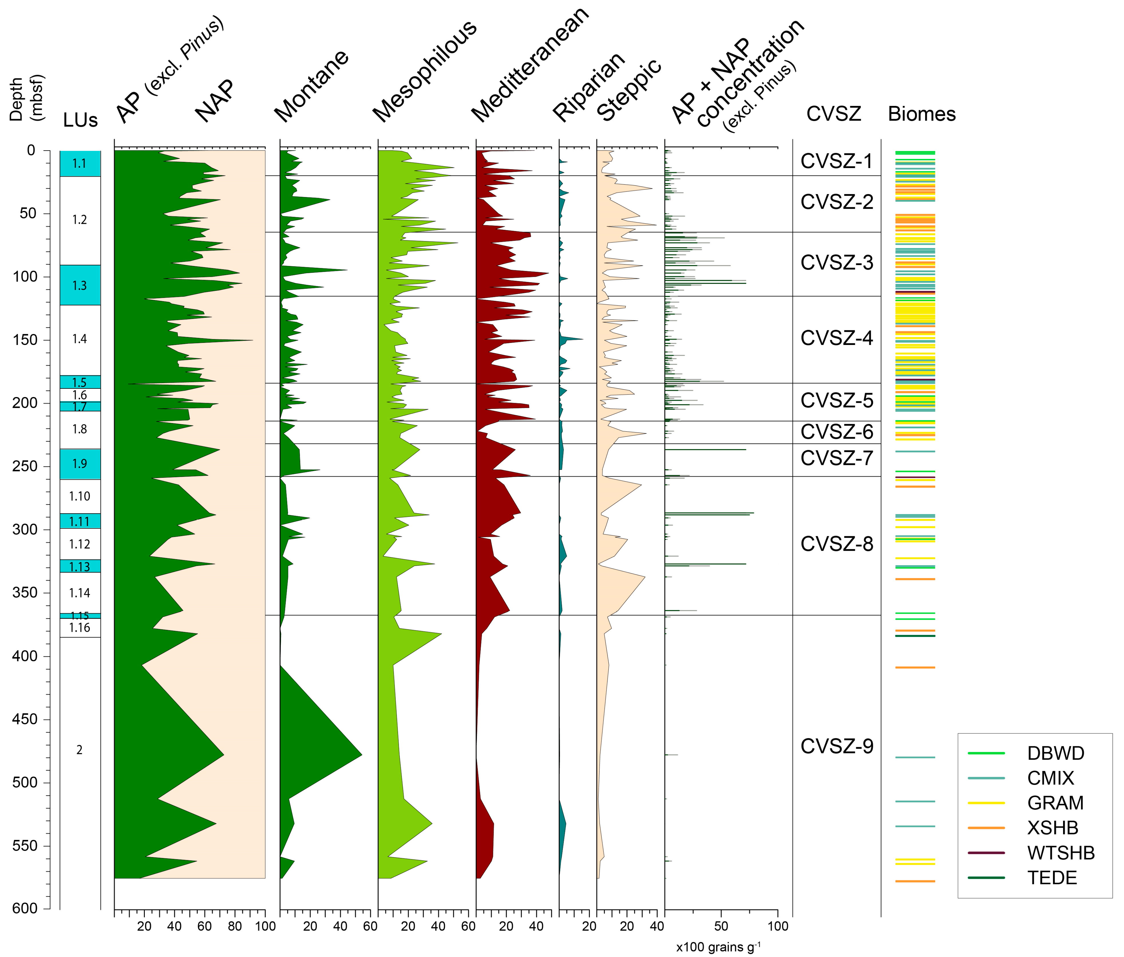
Figure 1. Map of the Gulf of Corinth area indicating the location of site M0078 (modified from [25,26]). In the inset map, the location of regional pollen records is also represented with black dots: Ioannina (I), Lake Ohrid (LO), Lake Prespa (LP), Tenaghi Philippon (TP) and Kopais (K).
Quaternary 06 00030 g001
Table 1. Pollen assemblage zone (CVSZ) description, reconstructed biomes and inferred vegetation. Depth is in mbsf; PS: pollen sum excluding Pinus; mean percentages/concentration (unless stated otherwise); number of samples in each biome.
CVSZReconstructed
Biomes
Pollen Assemblages Inferred Vegetation
CVSZ-1
Depth: 20, 19–0
Sample no: 12
Mean PS: 195
Dominant:
DBWD (5)
CMIX (5).
Other:
GRAM (2)
AP: 52.5% (max: 73%; min: 33%); AP conc. 279 grains g1 (max: 1024 grains g1); Mediterranean: 14.12% (max: 38%); Quercus ilex-type: 10.8%; mesophilous: 27.27%; Quercus robur-type: 24%; montane:8.6% (max: 47%); Cichorieae: 14% (max: 21%); Chenopodiaceae max: 10%Mesophilous tree dominant with prominent peaks of Mediterranean. Oak forests comprise Quercus robur-type (up to 47 %) and Quercus ilex-type (up to 36%). Montane (mostly Abies) forests in higher elevations. Cichorieae dominant among herbs.
CVSZ-2
Depth: 65–20, 19
Sample no: 18
Mean PS: 310
Dominant:
XSHB (10)
Other:
GRAM (6)
CMIX (2)
AP: 52% (min: 32%); AP conc. 445 grains g−1 (min: 118 grains g−1); pollen conc. 866 grains g1; Mediterranean (max: 26%; min: 3%); Q. ilex-type: 12%; mesophilous max: 49%; Q. robur-type: 21.3%; steppic max: 37%; Artemisia max: 24%; Ephedra spp. max: 6%; Cichorieae max: 27%; Chenopodiaceae (max: 19%); Salix (max: 3%)Small expansion of steppe vegetation. Persistence of mesophilous tree taxa, mainly Q. robur-type. Mediterranean vegetation decreases. Montane elements (e.g., Abies) expand. Artemisia is the most abundant taxon among herbs, accompanied by Chenopodiaceae and Poaceae.
CVSZ-3
Depth: 116–65
Sample no: 23
Mean PS: 487
Dominant:
CMIX (11)
Other:
GRAM (8)
XSHB (3)
AP: 62% (max: 85%); AP conc.(max: 26,835 grains g1); pollen conc. 4346 grains g1 (max: 32.295 g g1); Mediterranean (min: 9.6; max: 48%); Q. ilex-type: 27,4% (max: 48%); mesophilous: 21.1% (max: 55%); Q. robur-type: 12.2%; Q. cerris-type max: 29%; montane max: 29%; steppic max: 28%; Artemisia max: 24%; Chenopodiaceae max: 15%; Asteraceae max: 15%; Poaceae max: 36%Alternations of expansion of Mediterranean sclerophyllous vegetation in lowlands and mixed oak forests in mid-altitudes with short intervals of steppe vegetation increase. Artemisia, Chenopodiaceae and Asteraceae characterize the steppe communities upcore. Poaceae dominate the lacustrine vegetation zone.
CVSZ-4
Depth: 185–116
Sample no: 37
Mean PS: 393
Dominant: GRAMM (24)
Other:
CMIX (9)
DBWD (1)
WTSHB (1)
AP: 49% (min: 20%; max: 92%); AP conc. 472 grains g1; pollen conc. 1200 grains g1; Mediterranean max: 39%, min:6%; Q. ilex-type: 19%; mesophilous: 14.8% (min: 4%; max: 29%); Q. robur-type: 8%; Cedrus max: 10%; Artemisia max: 10%; Chenopodiaceae max: 14%; Asteraceae max: 33%; Cichorieae max: 27%; Poaceae max: 36%; Cyperaceae max: 13%; riparian max: 14%Open vegetation with Mediterranean populations; mesophilous are present in lower values. Trees persist, presenting minor decline. Montane taxa forests occurred in higher elevations.
CVSZ-5
Depth: 215–185
Sample no: 17
Mean PS: 255
Dominant: GRAMM (10)
Other:
DBWD (3)
CMIX (3)
XSHB (1)
AP: 46% (max: 69%; min: 9%); AP conc. 765 grains g−1 (max: 2018 grains g−1); Mediterranean: 19.9% (max: 40%, min: 6%); Q. Ilex-type: 18.5%; mesophilous: 14.6% (max:35%; min: 6%); Q. robur-type: 8.4%; montane (max: 17%; min: 2%); Cedrus: 2% max: 7%; Artemisia max: 14%; Chenopodiaceae max: 16%; Cichorieae max: 19%; Asteraceae max: 15%; Poaceae: 13% (max: 52%)Mediterranean tree taxa dominant with prominent peaks of mesophilous taxa. Alternations of grassland vegetation with mixed oak forests comprising Q.ilex-type (7.5–37.5%) and Q. robur-type (3–17.6%). Among herbs, Poaceae prevail in the coastal zone. Abies and Cedrus are present in the montane zone.
CVSZ-6
Depth: 233–215
Sample no: 5
Mean PS: 158
Dominant: GRAMM (3)
Other:
CMIX (1)
XSHB (1)
AP: 35% (min: 28%); AP conc. 211 grains g1; pollen conc. 664 grains g1; Mediterranean: 7.2%; Q. ilex-type min: 4%; mesophilous: 16.2%; Q. robur-type: 10% (max: 28%); montane max: 10%; steppic max: 33%; Artemisia max: 10%; Chenopodiaceae max: 18%; Cichorieae max: 14%; Poaceae max: 28%Open herbaceous vegetation with increased abundances of steppe taxa. Declined Mediterranean populations; persisting mesophilous taxa dominated by Q. robur-type.
CVSZ-7
Depth: 259–233
Sample no: 4
Mean PS: 282
DBWD (1)
CMIX (1) WTSHB (1) GRAM (1)
AP: 56% (max: 70%); AP conc. 3440 grains g−1; pollen conc. 5113 grains g1; Mediterranean: 22.3% (max: 36%); Q. ilex-type: 17%; mesophilous: 17.3% (max: 30%); Q. robur-type: 14%; montane: 14%; Abies max: 19%; Pinus max: 74%; steppic max: 8%; Artemisia max: 6%; Cichorieae: 8% (max: 13%)Mediterranean tree taxa prevail. Forests characterized by Q. ilex-type (7.2–26%) and Q. robur-type. Pinus and Abies present high abundances. Cichorieae are dominant among herbs.
CVSZ-8
Depth: 369–259
Sample no: 15
Mean PS: 200
Dominant: GRAM (6)
Other:
CMIX (3)
DBWD (3)
XSHB (2)
AP: 46% (max: 69%; min: 23%); AP conc (max: 33,852 grains g1; min: 83 grains g1); pollen conc. 5881 grains g1 (max: 51,373 grains g1); Mediterranean: 16% (max: 30%); Q. ilex-type max: 30%; mesophilous: 26% (max: 39%); Q. robur-type max: 40%; montane: 7%; Abies max: 18%; Artemisia max: 8%; Chenopodiaceae max: 26%; Cichorieae max: 18%, Asteraceae max: 14%; Poaceae max: 19%Alternations of periods characterized by mesophilous, accompanied by montane and Mediterranean trees, and open vegetation. Forests mainly characterized by expansion of Q. robur-type along with Q. ilex-type.
CVSZ-9
Depth: 580–369
Sample no: 10
Mean PS: 146.9
Dominant:
XSHB (3)
CMIX (3)
Other:
GRAM (2) DBWD (1)
TEDE (1)
AP: 40% (min: 17%); pollen conc. 324 grains g1; Mediterranean max: 12%, min: 2%; Q. ilex-type: 5%; mesophilous max: 40%; Q. robur-type: 9.3%; montane: 8%; Cedrus: 5.6% (max: 51%); Pinus (max: 70%, min: 7%); Chicorieae max: 38%; Poaceae max: 16%Poor preservation and/or low counts of pollen grains in several horizons. Extensive open herbaceous vegetation with increased abundances of steppic taxa. Mesophilous tree populations persist; Mediterranean contract over time. Montane taxa (mostly Cedrus) dominate in higher elevations.
Disclaimer/Publisher’s Note: The statements, opinions and data contained in all publications are solely those of the individual author(s) and contributor(s) and not of MDPI and/or the editor(s). MDPI and/or the editor(s) disclaim responsibility for any injury to people or property resulting from any ideas, methods, instructions or products referred to in the content.

