Article

Landscape Response to Dynamic Human Pressure in the Paliouras Lagoon, Halkidiki Peninsula, Macedonia, Greece

1
Department of Earth Sciences, Sapienza University of Rome, 00185 Rome, Italy
2
Department of Environmental Biology, Sapienza University of Rome, 00185 Rome, Italy
3
Paleo-Science and History (PS&H) Independent Research Group, Max Planck Institute for Geoanthropology, 07745 Jena, Germany
4
Department of Geology and Geoenvironment, National and Kapodistrian University of Athens, 15772 Athens, Greece
5
School of Geology, Aristotle University of Thessaloniki, 54124 Thessaloniki, Greece
6
Leibniz Institute for Baltic Sea Research, 18119 Rostock, Germany
7
Institute of History, Jagiellonian University, 31-007 Krakow, Poland
*
Author to whom correspondence should be addressed.
Quaternary 2022, 5(4), 54; https://doi.org/10.3390/quat5040054
Submission received: 13 November 2022 / Revised: 1 December 2022 / Accepted: 6 December 2022 / Published: 16 December 2022

Abstract

:
High-resolution pollen analysis of a sediment core recovered from Paliouras lagoon (Greece) allowed us to reconstruct the environmental dynamics of the Halkidiki peninsula during the last 4000 years. Palynological results have been interpreted and compared with detailed historical data, showing distinct phases of human-landscape interactions from the Bronze Age until recent times. Pollen spectra revealed an environment characterized by Mediterranean vegetation, mixed deciduous forest, and pine stands from the Late Bronze Age until the 11th century CE. The first signs of human impact were attested during the Archaic period with the cultivation of Olea, Castanea, and Vitis in the inland of the study area. An intensive land management was highlighted by arboriculture and cereal cultivation (Secale and Hordeum group) in Roman times. Late Antique-Early Medieval times coincided with less human pressure due to warfare-related crises, leading to the expansion of the forest and the abandonment of fields colonized by Amaranthaceae. A massive increase in pastoral activities, suggested by the high percentages of Cichorieae during the Ottoman period, is possibly linked to the significant demographic growth of the nearby city of Thessaloniki in the 16th century CE.

1. Introduction

The palynological analysis of Holocene sediment sequences cannot disregard the relationship between vegetation and man. Although human impact is an interference in climatic and environmental processes, it is also a clear consequence of cultural choices [1], ([2], pp. 69–82), [3]. In recent years, the complex interaction between past environments and societies at different spatial and temporal scales has been the subject of an increasing number of publications. They used new analytical approaches for the reconstruction of past complex events, offering unexpected results and confirming the current request for detailed studies with high-quality data (e.g., [4,5,6]). In this respect, expanding our knowledge of key regions is essential, in particular for the Mediterranean basin, whose environment has been very sensitive to both climatic changes and social transformations [7].
Among all its neighbors, Macedonia has a long history with impressive archaeological evidence [8]. In terms of climate, the aridification of the Mediterranean area during the Late Holocene strongly affected Greece and, in particular, the coastal areas that experienced the most important changes. For this reason, coastal lagoons represent precious natural archives for the study of past environments (e.g., [9,10,11,12,13]). It has already been shown how pollen data from coastal deposits, combined with archeological and historical sources, offers invaluable insights into the natural and/or human processes of shaping the Greek landscape through millennia (e.g., [14,15,16]). During the last decades, several palaeoenvironmental studies on the Holocene coastal sites of the Aegean Sea have been carried out, focusing mainly on geomorphological, sedimentological, microfaunal and macrofaunal analyses (e.g., [9,10,11,12,13,14,15,16,17,18]). On the contrary, few pollen coastal sequences have been investigated so far (Palamari Bay [14], Marathon coastal plain [19], Elefsis Bay [20], Vravron marsh [9], Ismarida [21], Klisova lagoon [12]), and only one in the Halkidiki Peninsula, the Tristinika marsh [11]. Therefore, we present a new pollen sequence from the coastal lagoon of Paliouras, located in the western part of Halkidiki, in front of the Thermaic Gulf.
The Halkidiki Peninsula in Central Macedonia (Greece) constitutes a typical example of the Mediterranean region: its morphology is dominated by plains, hills, mountains, and plateaus surrounded by a wide coastland toward the North Aegean Sea. For this reason, the peninsula does not form a single geographic unit, but it is divided into different sub-regions, each with its own climatic and environmental conditions. Such differences in the territory of Halkidiki played an important role in the history of past societies: the mountainous landscape of the inner part was ideal for herders, whereas farmers and traders were mainly settled along the coasts [22].
The continuous sedimentation of the lagoon since the mid-Holocene, without high-energy river inflows as inferred by [23], makes it feasible for the reconstruction of local palaeoenvironmental changes through pollen analysis. Our aims are (1) to develop a high-resolution record of past vegetation for the Halkidiki Peninsula and (2) to compare pollen data with sedimentological and historical proxies in order to highlight natural and/or human-forced changes at different scales.

1.1. Study Area, Vegetation and Climate, Human Occupation
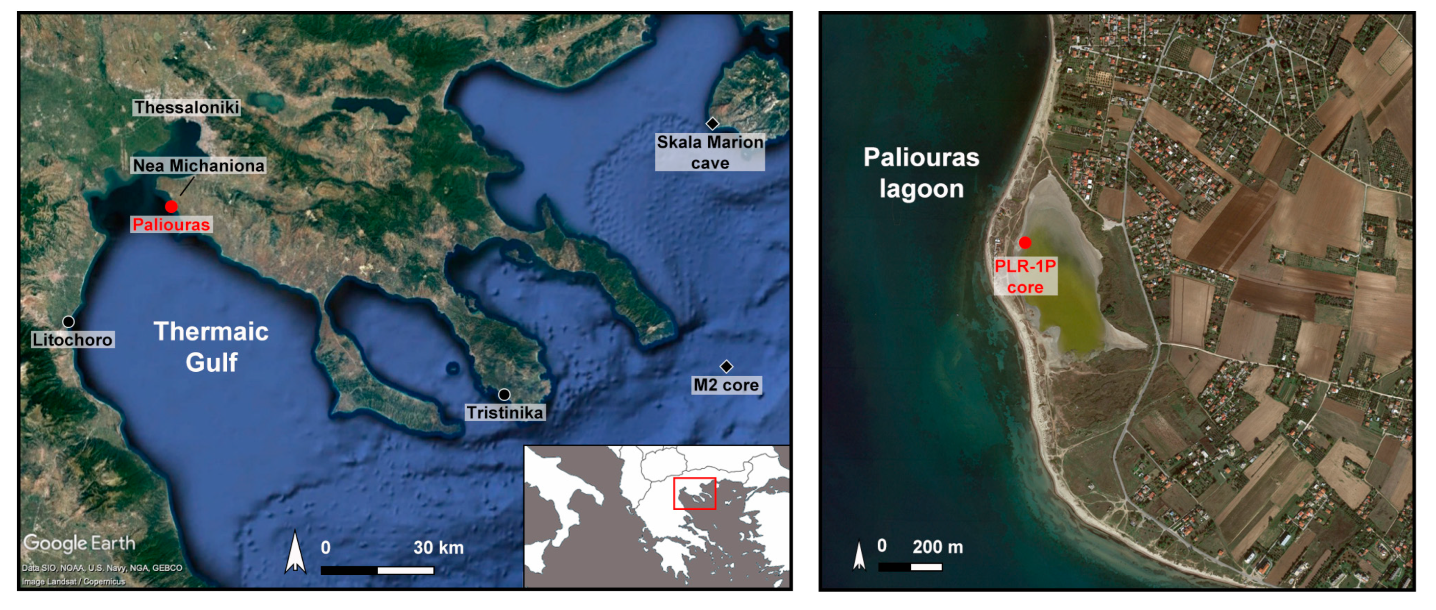
1.1.1. Site

Paliouras is a seasonal coastal lagoon located ~20 km south of the city of Thessaloniki (Figure 1), in a transition zone between the inner and outer Thermaic Gulf. The entire area is subjected to massive fluvial sedimentary inflows by the rivers Gallikos, Axios, Loudias, and Aliakmonas. Along the south-east coast of the Thermaic Gulf, sandy spit bars and lagoons developed after the Late Glacial Maximum when the sea level rose and intense erosion affected the east side of the gulf with a retreat of the coastline [24,25]. As described below, during winter and summer, seasonal winds affect sediment transport and modify the coastline. Paliouras lagoon was formed by a marine inundation of the coastal plain around 8000 cal. yr BP and filled with sediment throughout the Holocene [23]. The substrate consists mainly of fluvio-lacustrine Pliocene deposits of the Gonia Formation and terrestrial (red beds) Pleistocene sediments [23,26].
Paliouras lagoon was continually evolving until the Late Holocene, when an open lagoonal environment with frequent connections to the sea was established. Since 5900 cal. yr BP the lagoon has turned back to its initial enclosed conditions, with limited seawater exchanges and a consequent reduction in salinity. Nowadays, the lagoon extends along the coast for a length of 550 m and displays an elongated shape with a width that stretches from 50 to 260 m (Figure 1). The relief in the area is low, with flat beaches separated from the lagoon by sand dunes that reach almost 2 m; in the southern part, the sea occasionally overflows, creating a sandy promontory in the lagoon. The lagoon is fed by precipitation, runoffs, and seawater, but it is subjected to desiccation: during the winter-spring period springs, it is filled with water; instead, in the summer until the autumn, most of the water evaporates, revealing a whitish salt deposition [23].

1.1.2. Vegetation

The Halkidiki Peninsula is characterized by vegetation diversity due to differences in climate, altitude, and soil as well as a millennial human impact [27]. Altitude forest is represented by woodlands of Fagus sylvatica L. (Cholomontas, Stratoniko, and Athos mountains, e.g., [28]) and Abies borisii-Regis Mattf. (Mount Athos, [29]). The mid-altitudes are occupied by a thermophilous oak forest dominated by Quercus frainetto Ten. and Quercus pubescens Willd. [29,30]. Woodlands of Pinus halepensis Mill. only occur in the Halkidiki Peninsula and are distributed from 800 m a.s.l. to the coast [31]. In the coastlands, maquis of evergreen and broadleaved shrubs belongs to the Oleo-Ceratonion and Quercion ilicis formations. The dominant species, Olea europaea L., Quercus ilex L., and Ceratonia siliqua L., are associated with other Mediterranean plants such as Pistacia lentiscus L., Quercus coccifera L., Phyllirea latifolia L., Arbutus unedo L., and Myrtus communis L. [31].
In the study area, halophytic vegetation (mainly Amaranthaceae) covers the sand barrier on the west of the Paliouras lagoon, whereas sedges (Cyperaceae) and nitrophilous plants grow in the grazed wet and dry meadows on the east. The complex lagoon system is now included in protected natural reserve areas. Towards the inland, where the broader area is mainly occupied by annual crop fields (animal food), some well-known vineyards are found.

1.1.3. Climate

The climate on the western coast of the Halkidiki Peninsula is of a semi-arid Mediterranean type, ranging from cold semi-arid (steppe) in the lowlands and along the coast to a hot-warm Mediterranean in the uplands [32]. The annual precipitation average is 353 mm, and the mean monthly temperature ranges from 7 °C in January to 26 °C in July (data from Mikra for the period 1971–2000, [33]). In addition, wind regimes affect climatic conditions in the Thermaic Gulf. Cold air masses originating from the Balkans blow during the winter, whereas the presence of “Etesians” winds from the Northeast dominates the summertime [25].

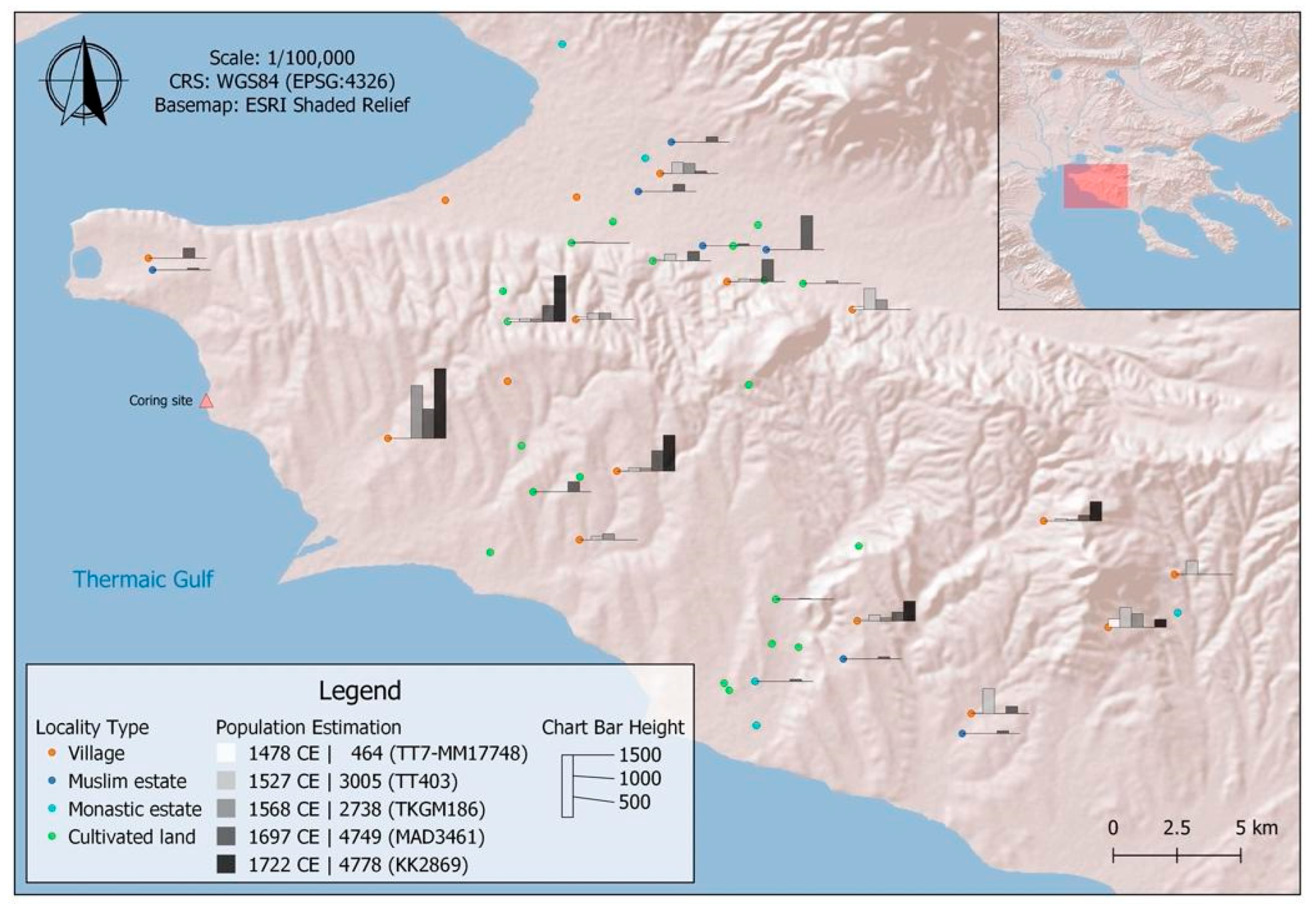
1.1.4. Archaeological and Historical Setting

With respect to the scattered evidence of human occupation in the Neolithic period, the number of sites in the Halkidiki Peninsula increased during the Bronze Age (3000-1100 BCE) [22]. Settlements moved from fertile areas of the inland to the coastland since the sea represented an important source of trade with the Mycenaean city-states of southern Greece. After the collapse of Mycenaean society, at the end of the Late Bronze Age and the Early Iron Age (12th–10th century BCE), the coastal settlements of Halkidiki probably received colonists from the south. From the Archaic to the Classical periods (8th–4th century BCE), a new intense phase of Greek colonization occurred, and the Halkidiki Peninsula was especially preferred for its abundant natural resources, such as forests, minerals, and arable lands [34]. The conquest of many Halkidiki cities by King Philip II in the mid-4th century BCE marked the beginning of the Hellenistic period, which was characterized by invasions, land confiscations, and general insecurity in the Macedonian kingdom [22]. The Romans conquered Macedonia in 168 BCE: an initial depopulation process of the countryside was testified by archaeological data, whereas economic prosperity based on food production and trade was testified from the 1st century CE onwards. The migration of colonists from Italy since the 1st century CE revived the economy and trade of the Halkidiki and led to the development of large estates and new roads. Thessaloniki and Macedonia more broadly became central to the framework of Roman power in the Balkans in the 4th century CE, serving as an important hub between the Mediterranean core of the Empire and the northern and central Balkan provinces, where warfare was endemic due to repeated invasions from outside the Danube, which with time led to the collapse of the Roman economy in these regions in the later 4th century [35]. In the following century, Macedonia effectively became the deep frontier zone, exposed to repeated enemy attacks, which intensified in the 7th century CE and continued into the early Middle Ages, leading to the Roman Empire’s loss of political control over most of Macedonia, probably including inland Halkidiki, in this period [36,37]. Nonetheless, archaeological remains suggest thriving settlement during Late Antiquity, at least in its earlier part, including numerous Christian basilicas [38,39] one of which has been excavated in the village of Epanomi, located ca. 5 km SW of the coring site [39]. A major change in the administration of the Halkidiki region came about with the creation of large estates and the foundation of numerous settlements that were fundamental for the Byzantine recovery starting in the 11th century CE [37]. At the same time, the emergence of monastic centers on Mt. Athos accelerated the population growth. The medieval economic and demographic growth collapsed as a result of the second plague pandemic in the middle of the 14th century CE [5,40], combined with increasing warfare in the following decades. The Ottoman conquest of Halkidiki, which began with the second siege of Thessaloniki in 1420 CE, led to a change in the demography profile with the settlement of Muslim populations and pastoralist tribes, which transformed the land use pattern of the Halkidiki [41] (pp. 123–161). In the following centuries, a noteworthy demographic growth, and a revitalization of agriculture and livestock farming were attested as new commercial trading was established. The Greek War of Independence that broke out in the first half of the 19th century CE did not severely damage the flourishing economy of the Halkidiki. The Balkan Wars changed the demography and ethnicity profile of the region, but the population quickly recovered after the Halkidiki was incorporated in the Kingdom of Greece [42], ([43], pp. 167–179).

2. Materials and Methods

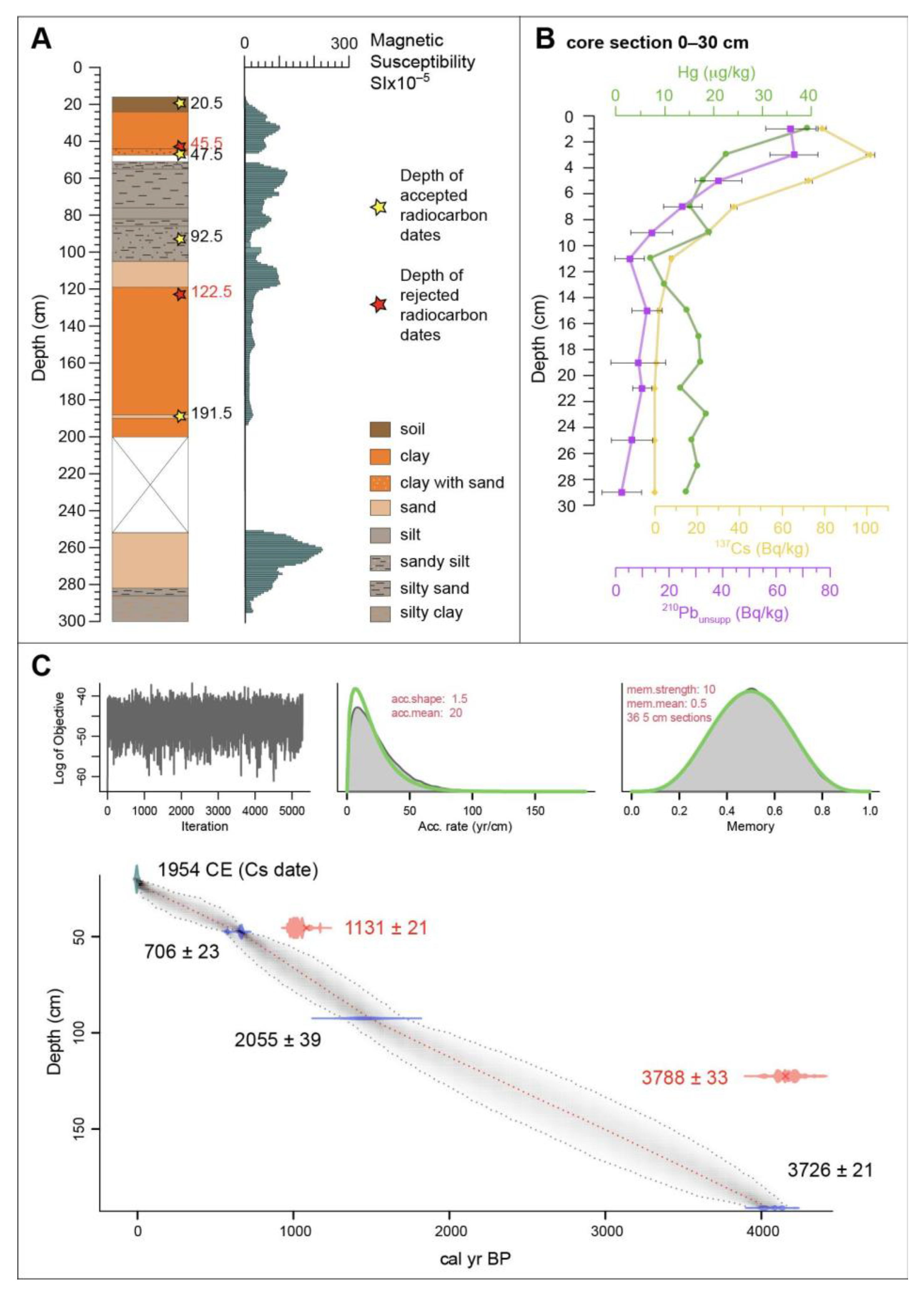
2.1. Lithology, Magnetic Susceptibility, and Mollusc Analysis

The PLR–1P core (40°26′21.4″ N 22°51′52.4″ E) was recovered in the Paliouras coastal lagoon at 0.25 m a.s.l. with a vibracore-drilling machine in 2020 (Figure 1). The 3 m sediment core has been described based on its lithology according to the sediment color and texture, the grain size, and the changes in the depositional structures. The low-field magnetic susceptibility profile was measured on the core using the MS2 Bartington Susceptibility meter and a MB2C sensor (ring sensor) at a step of 1 cm (Figure 2A). Molluscan analysis was carried out throughout the sequence except for the gap between 200 and 250 cm. Molluscs and their fragments were identified in a qualitative way. Environmental interpretations were based on the more thorough study in [23].

2.2. Age Depth Model

Five sediment samples and one molluscan shell (Table 1) have been measured for 14C dating with an accelerator mass spectrometry (AMS) at the CIRCE (Center for Isotopic Research on the Cultural and Environmental Heritage) laboratory of the University of Campania (“Luigi Vanvitelli”). The uppermost part of the core (16–100 cm) has been additionally sampled for Hg and 210Pb analyses. The Hg isotope measurements were conducted in parallel with the radionuclide analysis as an independent dating tool and to evaluate the water pollution and sediment disturbance [44,45]. Mercury isotopes were measured with a DMA-80 analyzer, and the data were calibrated against CRM (BCR) 142R certified reference material and the SRM 2709 soil standard. To validate the 210Pb analysis, the anthropogenic radionuclide 137Cs has been measured as an independent marker by gamma spectrometry with a Ge-detector (Figure 2B). Isotope and radionuclide analyses were performed at the Leibniz Institute for Baltic Sea Research (IOW). The 137Cs presence at 19 cm associated with the nuclear events of 1954 CE well correlates with the 14C date at 20.5 cm (1955.5 ± 1, Table 1) and contributes to the building of the age-depth model. The model refers to the palynologically investigated portion of the core (20–191.5 cm). It is based on a total of four 14C AMS dates in addition to the 137Cs-dated event (for the excluded dates, see Table 1) and has been carried out using the RBacon program [46] with the IntCal20 calibration curve [47] for the sediment samples and Marine20 for the molluscan shell [48] (Figure 2C).
Figure 2. Lithological and chronological sequence of the PLR–1P core from Paliouras lagoon (Central Macedonia, Greece). (A) Sediment succession with results of magnetic susceptibility. Stars show 14C samples (dates excluded from the age-depth model are in red); (B) radionuclide and Hg curves; (C) Age-depth model provided through the RBacon program [46] for the portion of the core from which dates are available (20–191.5 cm) (calibrated with IntCal20 and Marine20).
Quaternary 05 00054 g002

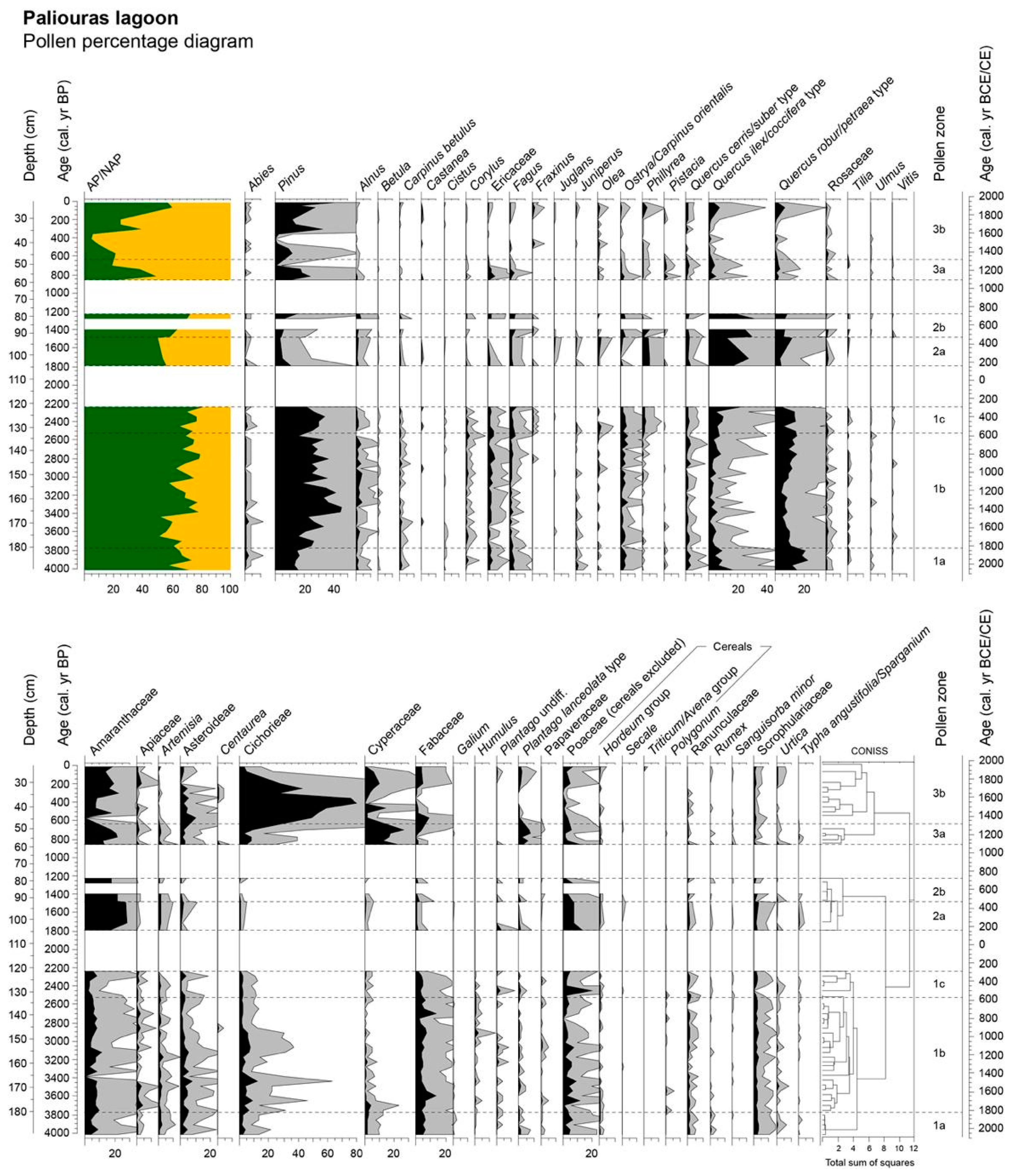
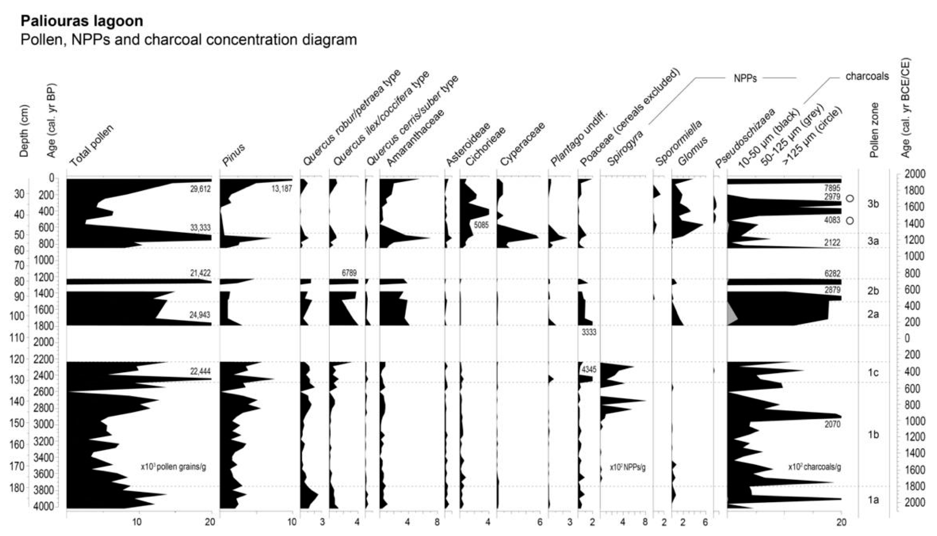
2.3. Pollen Analysis
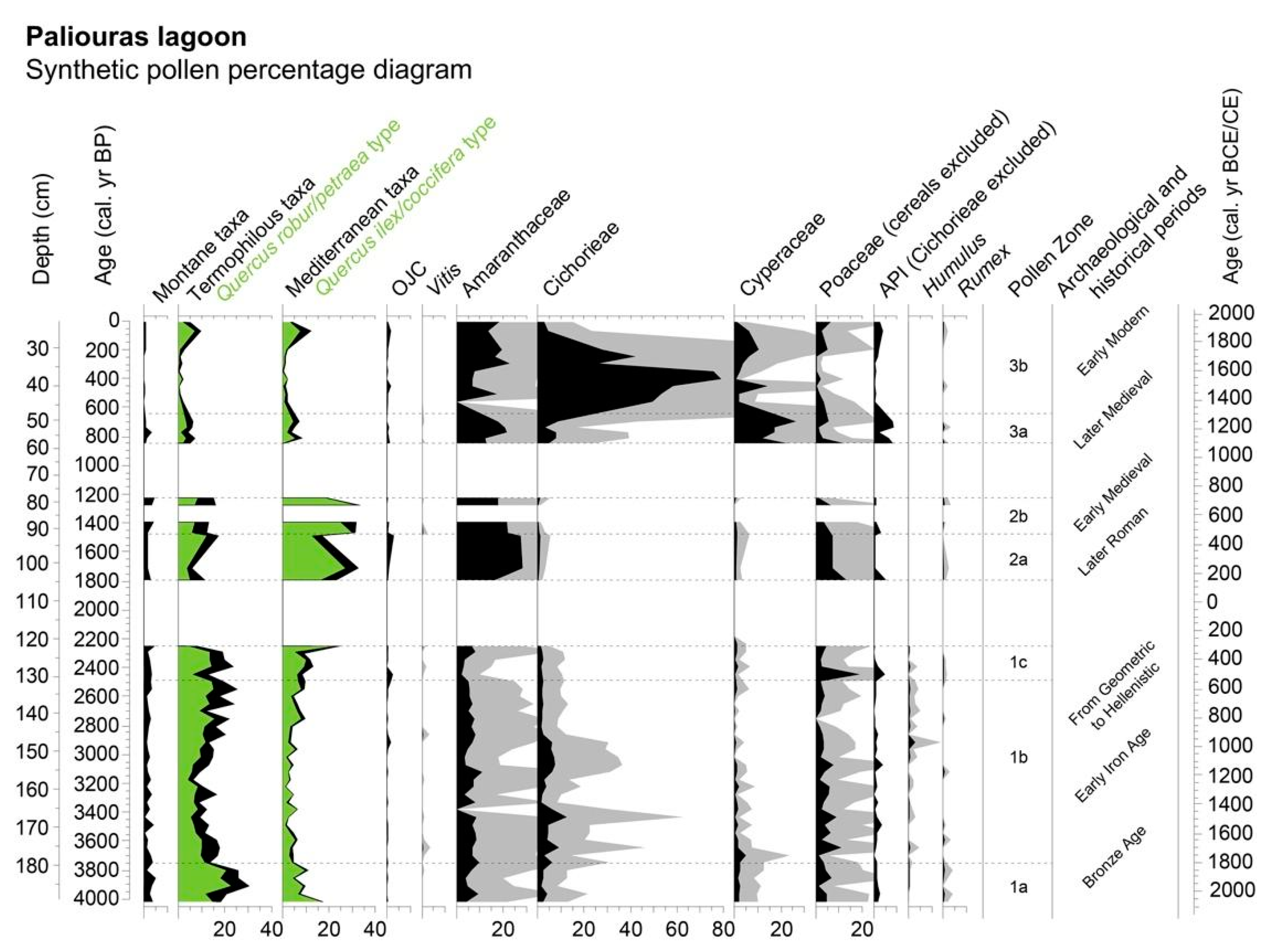
The pollen analysis was conducted on the first 2 m of the sequence due to the presence of an important gap and covers the last ca. 4000 years. The lower core portion, between 254 and 300 cm, has not been investigated because the majority of the sediment is too coarse to preserve pollen. The investigated portion of the sequence presents three gaps between 60.5 and 76.5 cm, 82.5 and 85.5 cm, and 105.5 and 119.5 cm. The gaps correspond to sandy horizons that do not allow preservation of the pollen grains; therefore, they have not been included in palynological analysis [49] (Figure 2A). The chemical treatment for pollen, non-pollen palynomorphs (NPP) and microcharcoal analyses were carried out in 57 samples. The samples were water-sieved with a 250 µm mesh in order to remove the coarse sand fraction and later chemically processed following ([49] modified) at the Laboratory of Archaeobotany and Palynology at Sapienza University of Rome. A known number of exotic Lycopodium spore tablets were added to each sample to estimate pollen, NPPs, and charcoal concentrations [50]. The supernatants were then sieved with a 10 µm nylon sieve in an ultrasonic bath for 10–15 min. Pollen grains have been identified using a transmitted light microscope at 400× and 630× magnification with the help of atlases [51,52] and reference pollen collections. Percentages were calculated on the basis of the sum of terrestrial spermatophytes. For other taxa, different pollen sums have been calculated as reported by [53] (pp. 455–496). Diagrams of pollen percentages and concentrations were drawn using the TILIA program [54]. CONISS cluster analysis [54] was performed in order to establish the pollen zones. Arboreal and non-arboreal pollen taxa have been included in the statistical analysis if higher than 2% of the total pollen sum. Cereal pollen has been distinguished into three groups (the Avena/Triticum group, the Hordeum group, and the Secale group) following [55] with the correction factor for glycerol jelly as the mounting medium [48]. The Hordeum group includes some species of wild Poaceae. In particular, the majority of grasses growing today near the Paliouras lagoon belong to Phragmites australis (Cav.) Trin. ex Steud., Hordeum marinum Huds., Scirpus holoschoenus (L.) Soják, and Phacelurus digitatus (Sibth. & Sm.) Griseb. Cichorieae, a native tribe of Europe, has fenestrate pollen grains and has been distinguished from Asteroideae in the Asteraceae family [56]. Pollen of Carpinus orientalis and Ostrya carpinifolia cannot be distinguished, and it is identified as a single pollen type: Ostrya/Carpinus orientalis type. Pollen grains of the genus Quercus have been sorted according to their morphology [57]: Quercus robur/petraea type includes all the deciduous oaks; the evergreen species except Q. suber are grouped in the Quercus ilex/coccifera type; and Quercus suber/cerris type encompasses the Q. suber, Q. cerris, and Q. crenata species. The OJC (Castanea, Juglans, Olea) group is based on [58], while the API (Anthropogenic Pollen Index) is adapted from [59]. Charcoal particles add information on past fire activity and, according to their sizes, indicate the geographical extent of the fires. The charred remains have been classified in three size classes (10–50 μm; 50–125 μm; >125 μm) measuring the length of the shorter axis, according to [60].

3. Results

3.1. Lithology, Magnetic Susceptibility, and Molluscs

The sedimentary record of PLR-1P from the bottom to 250 cm consists of greenish-gray silty clay and silty sand, overlaid by sand with molluscs and mollusc fragments. A gap follows due to the non-recovery of sediment during the core drilling. Higher in the sedimentary record, from 200 to 120 cm, the sediment is composed of very dark gray clay with organic material and abundant mollusc Cerastoderma glaucum accompanied by Hydrobia spp., followed by slightly lighter coloured clay. From 120 to 44 cm, alterations of greenish gray sand with pebbles and silty sands occur, containing gastropods, bivalves, and mollusc fragments. The gastropods are mainly represented by Hydrobia spp., Pirenella conica, and, to a lesser degree, by Cerithium vulgatum and Columbella rustica, while bivalves are represented by Cerastoderma glaucum and Abra segmentum. Finally, from 44 cm up to the top of the sequence, the sediment consists of dark yellowish-brown clay with organic material, which is covered by a thin soil layer. Magnetic susceptibility measurements are illustrated in Figure 2A. From the bottom of the sequence up to 250 cm, the values gradually increased, reaching the maximum at 261 cm. This enhanced layer is correlated with the greenish-gray silty clay. The lower values of magnetic susceptibility along the whole core were observed in the interval between 200 and 120 cm. This observation is in good agreement with the presence of a high content of organic material in the corresponding layer. Finally, in the upper part of the section, moderate values of magnetic susceptibility were observed with several fluctuations, indicating possible marine overflows as already described by Koukousioura et al. [23]

Pollen

A total of 47 different pollen types were identified. Pollen preservation was variable along the core, and the total pollen concentration showed significant oscillations spanning from 73 to 33,332 pollen grains/g (respectively at 135.5 and 52.5 cm). A total of at least 370 pollen grains were counted for each sample, excluding aquatic plants, spores, and NPPs. Three main pollen zones, divided into seven subzones, have been identified and described from the bottom to the top of the sequence (Figure 3 and Figure 4).
ZONE 1a (191.5–180.5 cm; ca. 4020–3800 cal. yr BP). The subzone showed a prevalence of AP. Total pollen concentrations were low, spanning from 7623 to 13,899 pollen grains/g. Arboreal vegetation dominates, as for all of Zones 1 and 2, and is largely represented by Quercus robur/petraea type (12–23%), which reached the highest percentage (23%) and concentration (2518 pollen grains/g) values of the core, followed by Quercus ilex/coccifera type (5–17%) and Ostrya/Carpinus orientalis type (2–4%). Pinus was abundant, with a mean of 24% and a maximum concentration value of 3089 pollen grains/g at 179.5 cm. The montane vegetation was mostly composed of Fagus (1–3%) and the Mediterranean shrubs Ericaceae (1–3%), Juniperus (0–3%), and Cistus (0–1%). Among the herbs, Amaranthaceae (4–9%), Fabaceae (5–6%), Poaceae (2–7%), and Asteraceae, with the subfamilies Asteroideae (2–5%), and Cichorieae (2–4%), were the most represented. Anthropogenic indicators (Rumex, Plantago lanceolata type, and Urtica) were well represented with low but constant occurrences (0–1%). Charcoals showed a peak in concentration (2340 charcoals/g) around 3910 cal. yr BP.
ZONE 1b (179.5–131.5 cm; ca. 3770–2500 cal. yr BP). The subzone was characterized by the lowest total pollen concentration (73 pollen grains/g) at 135.5 cm (ca. 2600 cal. yr BP). Apart from this isolated event, the pollen concentrations vary from 2893 to 13,716 pollen grains/g.
In this subzone, AP showed a constant increase (51–78%). Pinus is the main taxon, with values ranging from 22 to 55% and from 1429 to 5640 pollen grains/g. It reached the maximum percentage value of the entire sequence at 163.5 cm (ca. 3330 cal. yr BP). Quercus types remained the most abundant trees, Pinus apart. Quercus robur/petraea type decreased at the bottom of the subzone (min. 4%) and increased (max. 16%) in the upper part slightly but constantly, as evidenced by concentration values (from 9 to 2063 pollen grains/g). The Quercus ilex/coccifera type showed a similar trend spanning from 1 to 9%. Among the Mediterranean trees and shrubs, Phillyrea increased at the end of the zone (max. 5%), when Ericaceae reached the highest value of the entire sequence (5%). Olea showed a first peak (1%) at 147.5 cm (ca. 2920 cal. yr BP) and an increasing trend towards the end of the subzone. Alnus, Fagus, and Ostrya/Carpinus orientalis types fluctuated throughout the subzone, not exceeding 3%.
Herbs were dominated by Amaranthaceae and Fabaceae, followed by Asteroideae and Cichorieae. Poaceae numbers slightly decreased at the end of the subzone but were still abundant (min. 0–1%). Cyperaceae abruptly decreased, reaching the lowest value in the upper part of the subzone. The presence of Humulus (max. 3%) is notable. The concentration peak of Spirogyra in the interval 147.5–139.5 cm (max. 802 NPPs/g) is noteworthy, whereas charcoals reached the maximum value of 2070 charcoals/s at 147.5 cm.
ZONE 1c (129.5–121.5 cm; ca. 2450–2240 cal. yr BP). This subzone showed the highest AP value of the entire sequence (81%) at 121.5 cm. The total pollen concentration varied from 5591 to 13,979 pollen grains/g. Arboreal vegetation continued to be dominated by Pinus, which displayed the second highest peak of pollen concentration of the entire sequence (7527 pollen grains/g at 129.5 cm). The values of Quercus types were still high, with an increasing trend for the Quercus ilex/coccifera type that reached 23% and 3178 pollen grains/g in the last sample of the subzone. Mediterranean trees showed a slight increase due to the steady presence of Phillyrea (2–4%). Among shrubs, Juniperus almost disappeared, and Ericaceae decreased. Following the previous trend, Olea reached 2% in the first sample of the subzone and then reduced to zero.
Poaceae showed a peak both in percentage and concentration (respectively 19% and 957 pollen grains/g) at the bottom of the subzone, followed by an abrupt decline. Other important herbaceous taxa are Amaranthaceae and Cichorieae. The curve of Cyperaceae shows a small decline, whereas Humulus drops and then definitively disappears at the end of this subzone. As attested in the previous subzone, a high abundance of Spirogyra is registered (max. 595 NPPs/g).
ZONE 2a (104.5–92.5 cm; ca. 1790–1470 cal. yr BP). This subzone showed an equal contribution from AP and NAP. The total pollen concentration spanned from 11,831 to 24,943 pollen grains/g. A significant drop of Pinus was observed from the beginning of the subzone (8–12%) in comparison with the previous zones. Among AP, the most abundant taxon is Quercus ilex/coccifera-type (12–27% and 1723–4073 pollen grains/g), followed by Quercus robur/petraea-type (4–12%) and Ostrya/Carpinus orientalis-type (max. 4%). At 101.5 cm (ca. 1710 cal. yr BP), Juglans appeared (max. 1%), and Olea slightly increased (max. 2%). At the same time, the presence of cereal pollen was recorded not only due to the presence of the Hordeum group but also for the only important peak of Secale in the whole sequence (max. 1%).
Herbaceous taxa were overwhelmingly represented by Amaranthaceae, showing an abrupt increase both in percentage (max. 28% at 101.5 cm) and concentration (max. 4179 pollen grains/g at 104.5 cm). Poaceae (1–13%), which reached a second peak in concentration at 92.5 cm (993 pollen grains/g), were still present, along with a few other herbs not exceeding 3%. Among NPPs, spores of Glomus have been identified at 104.5 cm (212 NPPs/g). Concentration of the smallest charcoal fragments constantly increased with a significant presence of medium-sized charcoals around 1710 cal. yr BP (1959 charcoals/g).
ZONE 2b (91.5–78.5cm; ca. 1490–1225 cal. yr BP). Unfortunately, the zone was interrupted by one of the gaps; nevertheless, a single peak of Pinus, both in percentage (26%) and in concentration (4817 pollen grains/g) is attested at the end of this subzone, at 78.5 cm. The Quercus ilex/coccifera type still dominates among AP (19–32%) and reaches the highest concentration value of the entire sequence at 81.5 cm (6779 pollen grains/g). Both Alnus and Fagus showed an increase (1–4% and 2–4%, respectively). Within shrub vegetation, Ericaceae showed a slight increase (max. 2%). Amaranthaceae is still the dominant herbaceous taxon (22% and 3842 pollen grains/g), whereas Poaceae (1–6%) and Cichorieae (0–1%) revealed a decreasing trend. Glomus is present but in lower amounts (max. 90 NPPs/g), and charcoals reach two peaks at 91.5 and 81.5 cm (respectively 2079 and 6282 charcoals/g).
ZONE 3a (58.5–50.5 cm; ca. 850–700 cal. yr BP). The dominance of NAP mostly characterized the subzone (50–81%). Total pollen concentration significantly increased, displaying the maximum value of the whole sequence (33,332 pollen grains/g). The most abundant tree was, as in Zone 1, Pinus, with percentage and concentration values of respectively 12–30% and 638–7150 pollen grains/g. Nonetheless, the significant drop in Quercus ilex/coccifera types (max. 5%) and the continuous decreasing trend of Quercus robur/petraea types (max. 3%) marked the AP contraction. Mediterranean taxa with Ericaceae (max. 5%) and Phillyrea (max. 1%) showed a slight increase, whereas Carpinus betulus and Alnus declined, reaching the value of 0%.
Among NAP, Cyperaceae exhibited a substantial increase with a peak in percentages (27%) and concentrations (5424 pollen grains/g) at the top sample of the subzone. Amaranthaceae continued to prevail (13–21%) and reached the highest concentration value of the sequence (6989 pollen grains/g at 52.5 cm), while Poaceae decreased (1–12%) and Cichorieae slightly increased (1–9%), together with Plantago lanceolata (7–8%). The presence of cereal pollen (Secale and Hordeum groups) was significant among anthropogenic indicators. Charcoals showed a peak in concentration (753 charcoals/g) around 850 cal. yr BP.
ZONE 3b (44.5–21.5 cm; ca. 570–10 cal. yr BP). In the last subzone, NAP still prevails, reaching the highest value of the sequence (95%), at ca. 406 cal. yr BP. From this level upward, a progressive recovery of AP was recorded (max. 60%). Total pollen concentration increased constantly along the zone, from 2543 to 29,612 pollen grains/g of the top sample.
The AP trend was influenced by a progressive increase in Cichorieae, whose high values (28–79% and 3095–5085 pollen grains/g) have a peak at 38.5 cm (ca. 406 cal. yr BP). Such an overrepresentation of Cichorieae definitely affects the pollen spectrum. After this event, Pinus increases again, reaching 44% and 13,187 pollen grains/g in the uppermost sample. Quercus types displayed very low percentage values with a rapid recovery after ca. 201 cal. yr BP (Q. robur/petraea type: max. 7% and 1015 pollen grains/g, Q. ilex/coccifera type: max. 8% and 1128 pollen grains/g). Alnus, Fagus, and Ostrya/Carpinus orientalis type decreased through the subzone, almost disappearing. Olea pollen was present in low but constant amounts, displaying a small peak (2%) in conjunction with the apex of Cichorieae. Among herbs, other significant taxa are Amaranthaceae (7–23%), Cyperaceae (1–14%), Asteroideae (0–10%), and Poaceae (1–6%), whose concentration values rose in the top sample. Glomus, which reached its highest concentration value (553 NPPs/g at 44.5 cm), was well documented throughout the subzone together with Sporormiella (129 NNPs/g at 30.5 cm) and Pseudoschizaea (56 NPPs/g at 34.5 cm). An increase in charcoal concentration (4033 charcoals/g) was recorded in conjunction with the apex of Cichorieae, although the highest value of the sequence was attested in the uppermost sample (78,950 charcoals/g). Charcoals of the largest size peaked at 44.5 cm (591 charcoals/g).

4. Discussion

4.1. From the Bronze Age to the Hellenistic Period

The Paliouras pollen sequence started at ca. 4020 cal. yr BP (2070 BCE) during the Bronze Age, when the Halkidiki peninsula was inhabited by communities that settled by the sea, with easy access to maritime trade [22]. In Macedonia, human occupation during this period was characterized by permanent settlements with increasing village densities [61]. Until ca. 3800 cal. yr BP (1850 BCE) the pollen assemblage revealed a quite forested environment and pictured with a variety of vegetation types (Figure 5). Evergreen trees and shrubs (Quercus ilex/coccifera-type-evergreen oaks, Juniperus-juniper, and Ericaceae-heathers) represent the Mediterranean open forest alternated with grasslands (e.g., Poaceae, Asteroideae), which probably occupied the lowland. Pinus (pine), whose pollen groups are both Mediterranean and montane species, refers to the Halkidiki pinewoods, which are still found at the coasts in the Sithonia and Kassandra peninsulas and are nowadays formed by Pinus halepensis (Aleppo pine, [62,63]). Quercus robur/petraea-type (deciduous oaks), Ostrya/Carpinus orientalis-type (European/Oriental hornbeams), Carpinus betulus-type (common hornbeam), and Fraxinus-type (ash) composed the thermophilous mixed forest covering the hilly profiles of the inland. Montane taxa, mainly Fagus (beech) together with Abies (fir), occurred in the nearby mountains of Cholomontas to the north-east of Paliouras. The main herbaceous taxa represent the typical plant assemblage of the coastal dunes, which are constituted by dry and wet meadows (Amaranthaceae, Cyperaceae, as well as Poaceae, whose pollen refers to both grasses and reeds). The anthropic impact was added to the complexity of environments. A series of pollen indicators can be attributed to human presence, but all of them are rare and sparse. The land was used for agricultural and pastoral activities as indicated by API (mainly Plantago-plantains and Urtica-nettle), Cichorieae, and Rumex (docks), as well as other anthropogenic taxa, including Olea (olive) and Vitis (grapevine). However, the fields were probably located far from the lagoon, towards the north and south proximal areas of the settlements (see contemporary archaeobotanical evidence from Toumba Thessaloniki and Mesimeriani Toumba [64] (pp. 269–290), [65]. Among the anthropogenic indicators, the low and continuous percentage values of Olea at Paliouras could also refer to its natural presence in the Mediterranean coastal environment. On the other side, hints of incipient olive cultivation have been found later during the Late Bronze Age in the pollen record of Tristinika in Halkidiki [10], as well as in sequences from southern and northern Greece (e.g., Lake Lerna [16,66], Gialova lagoon [67], Vravron [20], Tenaghi Philippon [68]). A similar reasoning can be made for cereals, in particular for the scarce evidence of the Hordeum group that is present all along the sequence but with low values. This low cereal finding could be attributed to the soil salinity and local climatic factors, mainly the winds coming from the north-northeast, that made the local population set the fields far from the lagoon. The wide abundance of Cerastoderma glaucum, a typical euryhaline bivalve of transitional ecosystems that inhabits the Mediterranean lagoons, pointed to partial temporary sea-water exchanges that produced a partial increase in the lagoon’s salinity [69,70], which was confirmed by the low magnetic susceptibility measurements (Figure 2A).
At the same time, it should be noted that this pollen type also groups wild grasses of the genus Hordeum still present in the study area (see Materials and Methods). Since 3000 BCE, the number of Bronze Age settlements has mainly increased along the Aegean Sea and replaced the Neolithic villages [22], but the social structure made up of isolated and economically individual sites did not lead to large-scale food production [71]. From ca. 3750 cal. yr BP (1800 BCE), the oak-dominated woodland abruptly declined to the advantage of pinewood (Figure 3). In terms of biomass, there was a forest reduction clearly recorded by the decreasing concentration of AP that was not accompanied by an increase in Pinus values (Figure 4). It means that the environment became less forested than before and probably more oriented to dry climatic conditions. In the absence of paleoclimatic reconstructions for the study area, we generally referred to climatic data from the region. Since paleoclimatic proxies from the North Aegean Sea [72] and the Balkans in general [73] recorded fluctuating conditions during this period (with a wetter phase from 3800 cal. yr BP followed by reduced precipitation until 3400 cal. yr BP). It is likely that the forest exploitation for economic activities during the Late Bronze Age, as shown in the Paliouras record and also displayed by peaks of charcoal concentration related to the burning practices of ancient populations (Figure 4), favored the spread of Pinus. Among pines, Aleppo pine, adapted to coastal Mediterranean zones, is drought-tolerant and very resilient to fire, which seems to well describe the area at that time. Archaeological data confirmed the development of new settlements throughout the Halkidiki Peninsula in this period [74] (pp. 643–659), and palaeoenvironmental data evidenced the increased human pressure in southern Greece [16,75] and in the Struma River valley in southwestern Bulgaria [76]. In accordance with that, it is also interesting to note that the abundance of Pinus in pollen assemblages of southern Greece has been mainly interpreted as the expansion of coastal pinewoods during the Late Holocene [19,66,77]. Concentration values showed a continuous decrease of evergreen and deciduous oaks, accompanied by the expansion of Pinus (Figure 4), until the Early Iron Age. This trend can be attributed to intense human activity and, in particular, to the high demand for fuel for metallurgical production. Historical sources demonstrate that from the 10th century BCE southern Greek populations arrived in Halkidiki, probably attracted by the mineral (gold and copper) and timber resources of the region [78]. A similar reduction of broadleaved and evergreen vegetation is also observed in the pollen diagram of the Tristinika marsh [11]. The evidence that mainly oaks were affected by systematic fires in the Paliouras region is in agreement with the evidence of intentional fires of oak forests through the Mediterranean, which favored the expansion of pyrophytic taxa such as Pinus and Ericaceae [75,79,80,81]. In this respect, paleoclimatic data from Skala Marion Cave (North Aegean Sea [71]), Sofular Cave (South Black Sea [82]) and Jeita Cave (northern Levant [83]) revealed wet conditions due to the North Sea-Caspian precipitation pattern from ca. 3400 cal. yr BP (1450 BCE), which is not consistent with a natural contraction of oak forests, confirming a human-induced environmental change. On the other hand, the OJC and API curves (including scattered cereal grains) testify to low human impact as inferred for the previous period (Figure 5). The area could have been mainly designated to timber, fish, salt, and metal production, as witnessed by the rise of emporia along the coast of the Thermaic Gulf [34]. The very low values of anthropogenic pollen indicators at Paliouras compared to other regions [75] can be explained by the preference of the local communities for metallurgical activity over agriculture and herding [34,84].
After ca. 2850 cal. yr BP (900 BCE), the percentage and concentration pollen diagrams show a recovery of thermophilous trees together with Mediterranean vegetation (Figure 3, Figure 4 and Figure 5). Such an expansion of oak-dominated forests is generally recorded by AP concentration values and combines with a climatic trend towards wetter conditions recorded in the eastern Mediterranean [71,72,85,86]. Since the most intense phase of colonization from southern Greece is well attested in Halkidiki from the Geometric period (10th–9th century BCE) onward [22], we argue that human activities were mainly located along the coasts due to trading routes with the rest of Greece. Fagus also increased in this period (max. 4%, Figure 3), as recorded in palynological sequences from southeastern Bulgaria. Marinova and colleagues [76] linked the beech increase directly to the human activity that favored the tree. This may have involved a large area, thus also being visible at Paliouras. In fact, even if the site lies in the thermo-Mediterranean climate zone, benefiting from the sea influence, it is affected by the meso-supra-Mediterranean climate of the northern zones at higher elevation and has captured their environmental signal.
In the Paliouras lagoon, pollen record spores of Spirogyra, a freshwater alga, seem to indicate a higher contribution of freshwater and, consequently, a possible reduction of the salinity (these spores could also testify to a phase of shallow and stagnant water; see [19,87]. As a matter of fact, Koukousioura and colleagues [23] have highlighted the progressive establishment of meso-oligohaline conditions in the lagoon after ca. 3500 cal. yr BP onwards. The association of Hydrobia spp., Pirenella conica, Abra segmentum, and Cerastoderma glaucum confirms shallow oligohaline lagoonal conditions [21], ([88], pp. 411–493), [89], supported by the elevated magnetic susceptibility values (Figure 2), while the presence of the marine species Columbella rustica and Cerithium vulgatum testifies to a slight influence of marine overflows in the oligohaline lagoon [21].
There are no clear signals of pastoral and agricultural activities in the surrounding area from the Paliouras pollen record due to the scarce amount of cereal pollen and the slight decrease of API and Cichorieae (Figure 5). At Tristinika, a contemporary drop of cereal and olive curves suggest the abandonment of the fields in the vicinity of the marsh [11]. From ca. 2600 cal. yr BP (650 BCE), corresponding with the Archaic period, the OJC curve started to increase due to the spread of Olea and, in a later phase, Vitis. This evidence confirmed the expansion of tree cultivation in the inland, where more sedentary settlements were established. As a matter of fact, the Paliouras pollen record may reflect changes in the land management of the study area connected with the site of Aenea (near the modern Nea Michaniona, Figure 1), which flourished during the Archaic period [32]. Systematic cultivation of Olea in Halkidiki seems to have started in the Archaic period [10], whereas in southern Greece it was attested even during the Geometric period [9,16,66,90,91]. Charred olive stones from the 6th century BCE have been found in Thessaloniki Toumba, a settlement near the city of Thessaloniki [64]; they confirmed the presence of olive groves along the eastern coastline of the Thermaic Gulf. The local production of wine for consumption and trading was also evidenced by archaeobotanical remains from the contemporary site of Karabournaki, located in the same area [92].
The continuous presence of Humulus (hops) pollen starting from the end of the previous period is noteworthy (Figure 3). There is no clear evidence of the cultivation of hops in Europe before Roman times, although its presence in archaeological contexts dates back to the Neolithic period [93,94]. This herb was probably collected in the wild and used as medicine, food, or for textile production [95,96]. It is likely that the presence of Humulus pollen in the Paliouras record is related to its use around the lagoon as an edible plant or for therapeutic purposes.
A peak of Mediterranean vegetation, mainly evergreen oaks, was recorded during the Hellenistic period (ca. 2240 cal. yr BP, 290 BCE). In southern Greece and the Levant, a contemporary dry phase was recorded by stable isotope data, suggesting a possible climatic constraint for the Paliouras pollen signal [85], ([97], pp. 363–391), and [98]. Nonetheless, the Hellenistic period was a period of political instability when the Kingdom of Macedonia was the centerstage of severe, often destructive, military activities first between the Hellenistic kings and then between the Romans and Macedonia rulers [22]. Unfortunately, we cannot say more about the following period due to the presence of sandy levels that do not contain pollen (from 120 to 105 cm).

4.2. The Later Roman and the Early Medieval Times

The pollen record resumes at ca. 1790 cal. yr BP (160 CE), corresponding to the Roman period. Following the previous vegetation trend, the expansion of Mediterranean oaks continued, as recorded by both percentage and concentration values. However, Pinus reduced significantly, and the medium-sized charcoals displayed a concentration peak at ca. 1710 cal. yr BP (240 CE, Figure 3 and Figure 4). This could be related to an increase in the biomass; in fact, it has been proved that an increase in wildfires in the Mediterranean area is related to a major biomass availability [99]. As already mentioned, in the southern Balkans the climatic trends are ambiguous. In the North Aegean Sea, the marine core south of Halkidiki peninsula records an arid trend until 1700 yr BP [100], well corresponding with the spread of evergreen trees and regional fires, although the speleothem of Skala Marion cave records a general phase of enhanced precipitation [71]. The reduction of the pine forest could be linked to climatic factors and, to a certain extent, influenced by human activities, resulting in the spread of Mediterranean oaks. Such an exploitation of pinewoods made by Roman populations can be likely addressed to timber production, as attested by palynological data from the Balkans and southwestern Bulgaria [75,101,102]. Nonetheless the effect of increased precipitation in the Paliouras area during this timeframe seems to be recorded by herb taxa: the increase of Poaceae concentrations could reflect the spread of reed vegetation rather than of grasslands and would suggest the expansion of the wetland around the lagoon (Figure 4). On the contrary, the abrupt increase of Amaranthaceae (reaching 28%, Figure 3), whose concentration values tripled with respect to the pre-Roman period (Figure 4), seems to suggest the colonization of halophytic vegetation due to increasing salinity. As already mentioned, previous palaeoenvironmental data from the Paliouras lagoon has recorded a decrease in salinity during the Late Holocene [23]. The Amaranthaceae family, moreover, includes several cultivated plants, such as chard and spinach, and its increasing values can also be interpreted as the anthropogenic signal of the expansion of cultivated fields close to the lagoon.
The appearance of Juglans (walnut) and the contemporaneous increase of Olea testify to the highly developed land use of the area during Roman times. Likewise, Castanea (chestnut) is significantly attested in this period (Figure 5). Since the Early Holocene, both walnut and chestnut have been a part of the natural landscape of Greece [103,104]. In northern Greece, peaks of Juglans pollen during Roman times attest to walnut cultivation in the region, as well as its reduction in the Late Antiquity [90,100]. The attempt to reconstruct the history of the spread of chestnut is more complex. The presence of a Glacial refugia of Castanea in the southern Balkans was recorded at Ohrid Lake [105], but it is still uncertain in Greece [106,107]. However, its diffusion for cultivation was clearly favored by the Romans as in the entire Mediterranean basin [57,108,109,110]. Among the other anthropogenic indicators, cereals (the Hordeum group and Secale-rye) attest to the intensification of agricultural activities around Paliouras and confirm the economic landscape modeled by the Romans. In particular, rye has been present as a weed since the Iron Age in southeastern Europe, but it was cultivated in Roman times [75]. Although Pliny describes it as a “very poor food, useful only to prevent famine” [111], it has been argued that the spread of rye cultivation by the Romans was linked with the introduction of a new harvesting technology [112]. Considering this, it is likely that this cereal was cultivated close to the lagoon for its tolerance to extreme climatic conditions and poor soils [113] (747–764), [114] (pp. 342–354). The intensification of Secale cultivation during the Roman period was also recorded at Tristinika marsh, where it mainly replaced olive groves [11].
From ca. 1390 to 1230 cal. yr BP (560–720 CE), corresponding to the Early Medieval period, evergreen oaks expanded even more, reaching the highest percentage value of the sequence (32% at ca. 1280 cal. yr BP-670 CE, Figure 3). Pinus slightly increased as well as thermophilous and montane taxa, confirming a clear spread of woodlands (Figure 5). In the lagoon, Amaranthaceae continued to dominate, confirming the establishment of a salt environment colonized by halophytes (Figure 3). Interestingly, a drop in OJC was recorded from ca. 1390 cal. Yr BP (560 CE) and testified, together with a reduction of cereals and API, to the contraction of cultivated lands (Figure 5). Such palynological evidence of the diminishing human pressure in the study area is in agreement with historical and archaeological data, which indicate that from the later 4th century CE, numerous small and large-scale military activities concentrated in the Central Balkans, leading to the collapse of the Roman socio-economic system [35]. The significant reduction of the human pressure around Paliouras and the rewilding of the landscape provide another example of the sensitivity of the local landscape to political instability, suggesting mostly anthropogenic control of the landscape in the Late Holocene.

4.3. The Later Medieval and Early Modern Times

The sediment core includes sands from 78 to 59 cm, which do not allow pollen preservation; as a result, vegetation reconstructions from the 8th and the first half of the 11th centuries CE were not recorded. From ca. 850 cal. yr BP (1100 CE), Pinus continued to increase at the expense of both Mediterranean oaks and thermophilous vegetation, which abruptly reduced (Figure 5). The expansion of pinewoods, together with shrubland of Ericaceae and Pistacia types (Figure 3), describes a degraded environment and could have been favored by human activities in the area, whose impact is mainly recorded by the anthropogenic indicators. Forest disturbance related to a new settlement wave and clearing of lands for agriculture may also be related to the peak of charcoal around ca. 850 cal. yr BP (Figure 4). The dominance of Plantago lanceolata type among API suggests the spread of pasturelands, whereas low values of OJC and cereal pollen point out the reduced presence of cultivated fields, even though the cultivation of the Hordeum group and Secale is still attested in the pollen record (Figure 5). It should be noted that changes in the agricultural system could have been partially affected by colder conditions during the early medieval climatic change, even if in the Aegean Sea paleoclimate models show relatively stable conditions [115,116]. Therefore, it is more likely that the socio-economic transformation related to the demographic growth and agrarian expansion of the Middle Byzantine period, lasting in Macedonia from the 10th/11th centuries until the mid-14th century CE [37,117,118,119], played a major role in the transformation of the landscape. At the same time, the vegetation of the lagoon is still mainly represented by halophytes, accompanied by a rapid expansion of Cyperaceae, which colonized parts of the wetland where salinity was reduced (Figure 3 and Figure 4).
Starting from ca. 570 cal. yr BP (1380 CE), a general opening of the landscape is highlighted both in percentage and concentration values, involving broadleaved and evergreen vegetation as well as montane taxa (Figure 5). Around ca. 400 cal. yr BP (1550 CE), the arboreal vegetation reached only 5%. Such a clearance of woodland correlates with the drastic expansion of Cichorieae, and to a lesser extent, Asteroideae, from pasturelands (both in percentage and concentration, Figure 3 and Figure 4). Indeed, Cichorieae is the main pastoral indicator in Mediterranean environments [56]. The overgrazing probably caused the depletion of the Ericaceae shrubland, whose percentage values reduced from the previous periods (Figure 3). A similar trend in vegetation dynamics due to herding practices was well attested by pollen sequences in southern Greece. At Lake Lerna in the Peloponnese, the establishment of an economic landscape made of pastures was recorded during the Ottoman period [16], whereas at Vravron marsh in Attica, the introduction of Arvanitic communities due to the repopulation of abandoned lands was postulated for the high Cichorieae abundances [9]. In northern Greece, a preference for animal husbandry over cultivation has been evidenced in the region of the Rhodopi Mountains and associated with the Vlachs pastoral economy (ca. 1200 CE, [120]). After the first conquest of Thessaloniki by the Ottomans, palynological evidence confirmed the expansion of animal husbandry connected with the migration of Turkish nomads into the region after 1500 CE [40,119,120].
In Halkidiki, this is most probably related to the arrival and establishment of Muslim nomadic groups (yürük or yörük) in the late 14th century CE, with a second wave around the middle of the 16th century CE [121,122]. In the Paliouras record, the intensification of pastoral activities during Ottoman times was also revealed by the presence of Sporormiella, a coprophilous fungus, as well as by indicators of erosion in open environments like Glomus and Pseudoschizaea (Figure 4). It should be mentioned that the high amount of Cichorieae pollen (max. 79% at ca. 410 cal. yr BP) could be partially influenced by taphonomic processes due to the better preservation and corrosion resistance of the Asteraceae pollen exine [123,124]. It is remarkable, in this context, that the expansion of pastoral economies started probably relatively soon after the onset of the second plague pandemic (its initial wave, the Black Death, dating in the area to 1347/1348 CE, [125]) without a clear rewilding phase otherwise visible in Macedonia [5], ([113], pp. 747–764). If this observation is not an artifact due to age estimation uncertainties, it would mean that the areas of western Halkidiki might have been the first areas to be taken over by incoming Turkish nomads, who took advantage of the cultivated lands and Christian villages abandoned after the pandemic. On the other hand, it is plausible that the remaining local population intensified the already present pastoral land use mode, as suggested by the API curve since the Later Medieval period, already prior to the nomad immigration. The landscape dynamics in the Paliouras area might have also been linked to the strong demographic growth of the nearby major city of Thessaloniki, which grew from ~10,000 inhabitants around 1400 CE to ~30,000 inhabitants in the 1520s CE (with another phase of pre-industrial urban growth occurring in the first half of the 18th century CE, from ~30,000 to ~70,000) [42,126,127], ([128], pp. 225–251). In this respect, it is generally accepted by historians that the decreasing forest cover in the Ottoman lands should be attributed more to the denser population of established peasants, who were in need of firewood, than to nomadic activity [129] (pp. 18–43). Particularly in Halkidiki, wood was needed as fuel for the furnaces of the mines (see evidence from Mt. Kalavros [130]). Thus, the deforestation process recorded at Paliouras in association with the highest Cichorieae abundances cannot be assigned solely to nomadic activity. In the case of western Halkdiki, we were able to compare landscape change in the early modern period with the local historical demographic data derived from Ottoman Turkish cadasters (Table 2 and Figure 6).
The intensive pastoral economy, reflected by the increasing curve of Cichorieae, might attest to the local population’s response to the demand for meat in the large, expanding urban center of Thessaloniki. The lack of further growth in the 18th century CE, even the decline in pastoral indicators, and the partial regrowth of forests, in turn, might be related to the decoupling of Thessaloniki’s supply network from its direct hinterlands: the size of the city now required larger-scale supply networks reaching beyond Macedonia. Severe climatic anomaly conditions during the 18th century CE were described for Northern and Southern Greece; however, incomplete climatic data for the Macedonia region do not allow consideration for farming and grazing deficits [91,131]. Mediterranean coastal sites are more vulnerable to hydrogeological changes than climatic oscillation [132]. Moreover, anthropogenic influence rendered the ecosystem more sensitive to moderate climatic changes, as witnessed in other Mediterranean sites [133,134]. Thus, from ca. 350 cal. yr BP (1600 CE) towards the Modern Era, the exponential growth of Pinus testified to the establishment of Mediterranean pinewoods along the coast of the Thermaic Gulf. Patches of evergreen shrubland were recorded by low percentage values of Mediterranean taxa (Quercus ilex/coccifera type, Phillyrea, and Ericaceae, Figure 3), whereas relatively recent samples showing cereal and OJC pollen point to the modern cultural landscape in the surroundings of the Paliouras lagoon (Figure 5).

5. Conclusions

The high-resolution pollen sequence from Paliouras (Central Macedonia, Greece) has revealed the changes in the vegetational assemblage in the Halkidiki peninsula from the Bronze Age until early modern times. The environment around the lagoon was characterized by Mediterranean vegetation, mixed deciduous forest, and pine stands from the Late Bronze Age until the 11th century CE. Anthropogenic pollen indicators suggest that hints of human impact started already in the Classical period, although the strongest effect of human activities on vegetation dynamics was attested from the Roman times onwards. These palaeoenvironmental changes of anthropogenic origin were punctuated by phases of warfare-related crisis leading to the collapse of local agrarian landscapes, both in the Hellenistic period and in Late Antique-Early Medieval times, which resulted in forest expansion and a general landscape rewilding. By comparing palynological data with detailed historical data, we have been able to find out that during the later Middle Ages, a similar collapse of the medieval cultivated landscape did not lead to a reforestation process. The increase in human impact in the 14th century CE was the result of the Ottoman economy, as documented in the historical archives. Pollen data revealed that both cultivation and pastoral activities were practiced near the area. A preference for livestock farming was associated with a demographic growth in the nearby large city of Thessaloniki and a possible high food demand during the 16th century. A further intensification of agricultural practices was attested in the Modern era. Climate changes only partially drive the vegetation variations. The human impact recorded in the pollen diagram and supported by historical sources was rather strong and, in some cases, masked the climatic signals. A more complete understanding of the complexity of the relations between climate and human activities surely demands local proxies.

Author Contributions

Conceptualization, L.M. and A.M., formal analysis, L.M., O.K. and M.M.; investigation, L.M., G.C.L. and E.A., visualization, L.M., C.V., G.C.L., writing–original draft preparation, L.M., C.V., G.C.L., K.K. and A.I. for Section 1, Section 2 and Section 5; and L.M., E.A., O.K., M.M., and K.V. for Section 3, Section 4 and Section 5; writing–review and editing, C.V., G.C.L., K.K., O.K., M.M., K.V., A.I. and A.M. All authors have read and agreed to the published version of the manuscript.

Funding

This research receive fundings from the Palaeo-Science and History (PS&H) Independent Research Group, Max Planck Institute for Geoanthropology.

Data Availability Statement

The data that support the findings of this study are available from the corresponding author upon request.

Acknowledgments

We would like to thank Elias Kolovos, Phokion Kotzageorgis, Georgios Vidras, and Christos Kyriakopoulos for acquiring and inputting the data from the Ottoman archival sources, and Theodoros Vakkas from the Geospatial Enabling Technologies (GET) in Athens for his help in the Ottoman database elaboration and mapping.

Conflicts of Interest

The authors declare no conflict of interest.

References

  1. Roberts, N.; Eastwood, W.J.; Kuzucuoglu, C.; Fiorentino, G.; Caracuta, V. Climatic, vegetation and cultural change in the eastern Mediterranean during the mid-Holocene environmental transition. Holocene 2011, 21, 147–162. [Google Scholar] [CrossRef]
  2. Kouli, K.; Masi, A.; Mercuri, A.; Florenzano, A.; Sadori, L. Regional Vegetation Histories: An Overview of the Pollen Evidence from the Central Mediterranean. In Environment and Society in the Long Late Antiquity; Izdebski, A., Mulryan, M., Eds.; Brill: Leiden, The Netherlands, 2019; pp. 69–82. [Google Scholar]
  3. Mercuri, A.M.; Florenzano, A.; Burjachs, F.; Giardini, M.; Kouli, K.; Masi, A.; Picornell-Gelabert, L.; Revelles, J.; Sadori, L.; Servera-Vives, G.; et al. From influence to impact: The multifunctional land-use in Mediterranean prehistory emerging from palynology of archaeological sites (8.0–2.8 ka BP). Holocene 2019, 29, 830–846. [Google Scholar] [CrossRef] [Green Version]
  4. Clarke, C.L.; Greve Alsos, I.; Edwards, M.E.; Paus, A.; Gielly, L.; Haflidason, H.; Mangerud, J.; Regnell, C.; Hughes, P.D.M.; Svendsen, J.I.; et al. A 24,000-year ancient DNA and pollen record from the Polar Urals reveals temporal dynamics of arctic and boreal plant communities. Quat. Sci. Rev. 2020, 247, 106564. [Google Scholar] [CrossRef]
  5. Izdebski, A.; Guzowski, P.; Poniat, R.; Masci, L.; Palli, J.; Vignola, C.; Bauch, M.; Cocozza, C.; Fernandes, R.; Ljungqvist, F.C.; et al. Palaeoecological data indicates land-use changes across Europe linked to spatial heterogeneity in mortality during the Black Death pandemic. Nat. Ecol. Evol. 2022, 6, 297–306. [Google Scholar] [CrossRef]
  6. Seim, A.; Marquer, L.; Bisson, U.; Hofmann, J.; Herzig, F.; Kontic, R.; Lechterbeck, J.; Muigg, B.; Neyses-Eiden, M.; Rzepecki, A.; et al. Historical spruce abundance in Central Europe: A combined dendrochronological and palynological approach. Front. Ecol. Evol. 2022, 10, 909453. [Google Scholar] [CrossRef]
  7. Pérez-Obiol, R.; Sadori, L. Similarities and dissimilarities, synchronisms and diachronisms in the Holocene vegetation history of the Balearic Islands and Sicily. Veget. Hist. Archaeobot. 2007, 16, 259–265. [Google Scholar] [CrossRef]
  8. Heurtley, W.A. An archaeological reconnaissance of Greek Macedonia (west of the Struma) in the Neolithic, Bronze, and Early Iron Ages. In Prehistoric Macedonia; 1 map, 112 figures, 24 plates; University Press: Cambridge, UK, 1940. [Google Scholar]
  9. Kouli, K. Vegetation development and human activities in Attiki (SE Greece) during the last 5000 years. Veg. Hist. Archaeobot. 2012, 21, 267–278. [Google Scholar] [CrossRef]
  10. Morellón, M.; Anselmetti, F.S.; Ariztegui, D.; Brushulli, B.; Sinopoli, G.; Wagner, B.; Sadori, L.; Gilli, A.; Pambuku, A. Human–climate interactions in the central Mediterranean region during the last millennia: The laminated record of Lake Butrint (Albania). Quat. Sci. Rev. 2016, 136, 134–152. [Google Scholar] [CrossRef] [Green Version]
  11. Panajiotidis, S.; Papadopoulou, M.L. Human-landscape interactions in Halkidiki (NC Greece) over the last 3.5 millennia, revealed through palynological, and archaeological-historical archives. J. Archaeol. Sci. 2016, 7, 138–145. [Google Scholar] [CrossRef]
  12. Emmanouilidis, A.; Panagiotopoulos, K.; Kouli, K.; Avramidis, P. Late-Holocene paleoenvironmental and land-use changes in Western Greece based on a sediment record from Klisova lagoon. Holocene 2022, 32, 485–500. [Google Scholar] [CrossRef]
  13. Susini, D.; Vignola, C.; Goffredo, R.; Totten, D.M.; Masi, A.; Smedile, A.; De Martini, P.M.; Cinti, F.R.; Sadori, L.; Forti, L.; et al. Holocene palaeoenvironmental evolution of the southern margin of the Salpi lagoon (Apulia, southern Italy). Quat. Intern. 2022. [Google Scholar] [CrossRef]
  14. Pavlopoulos, K.; Triantaphyllou, M.; Karkanas, P.; Kouli, K.; Syrides, G.; Vouvalidis, K.; Palyvos, N.; Tsourou, T. Paleoenvironmental evolution and prehistoric human–environment, in the embayment of Palamari (Skyros Island, Greece) during Middle-Late Holocene. Quat. Int. 2010, 216, 41–53. [Google Scholar] [CrossRef]
  15. Triantaphyllou, M.V.; Kouli, K.; Tsourou, T.; Koukousioura, O.; Pavlopoulos, K.; Dermitzakis, M.D. Paleoenvironmental changes since 3000 BC in the coastal marsh of Vravron (Attica, SE Greece). Quat. Int. 2010, 216, 14–22. [Google Scholar] [CrossRef]
  16. Vignola, C.; Hättestrand, M.; Bonnier, A.; Finné, M.; Izdebski, A.; Katrantsiotis, C.; Kouli, K.; Liakopoulos, G.C.; Norström, E.; Papadaki, M.; et al. Mid-late Holocene vegetation history of the Argive Plain (Peloponnese, Greece) as inferred from a pollen record from ancient Lake Lerna. PLoS ONE 2022, 17, 0271548. [Google Scholar] [CrossRef] [PubMed]
  17. Koukousioura, O.; Triantafyllou, M.V.; Dimiza, M.D.; Pavlopoulos, K.; Syrides, G.; Vouvalidis, K. Benthic foraminiferal evidence for and Paleoenvironmental evolution of Holocene coastal plains in the Aegean Sea (Greece). Quat Int 2012, 261, 105–117. [Google Scholar] [CrossRef]
  18. Triantaphyllou, M.V.; Pavlopoulos, K.P.; Kouli, K.; Koukousioura, O.; Dimiza, M.D.; Aidona, E.; Syrides, G.; Pallikarakis, A.; Goiran, J.P.; Fouache, E. Multiproxy paleoenvironmental reconstruction: The Piraeus coastal plain case study. Bull. Geol. Soc. Greece 2016, 50, 478–487. [Google Scholar] [CrossRef]
  19. Kouli, K.; Triantaphyllou, M.; Pavlopoulos, K.; Tsourou, T.; Karkanas, P.; Dermitzakis, M.D. Palynological investigation of Holocene palaeoenvironmental changes in the coastal plain of Marathon (Attica, Greece). Geobios. 2009, 42, 43–51. [Google Scholar] [CrossRef]
  20. Kouli, K.; Triantaphyllou, M.V.; Koukousioura, O.; Dimiza, M.D.; Parinos, C.; Panagiotopoulos, I.P.; Tsourou, T.; Gogou, A.; Mavrommatis, N.; Syrides, G.; et al. Late Glacial Marine Transgression and Ecosystem Response in the Landlocked Elefsis Bay (Northern Saronikos Gulf, Greece). Water 2021, 13, 1505. [Google Scholar] [CrossRef]
  21. Koukousioura, O.; Kouli, K.; Vouvalidis, K.; Aidona, E.; Karadimou, G.; Syrides, G. A multi-proxy approach for reconstructing environmental dynamics since the mid Holocene in Lake Ismarida (Thrace, N. Greece). Rev. Micropal. 2020, 68, 100443. [Google Scholar] [CrossRef]
  22. Tsigarida, E.B.; Xydopoulos, I. Halkidiki Landscape, Archaeology, and Ethnicity. In Mines, Olives and Monasteries: Aspects of Halkidiki’s Environment History; Gounaris, B.C., Ed.; Epikentro Publishers and PHAROS Books: Thessaloniki, Greece, 2015. [Google Scholar]
  23. Koukousioura, O.; Dimiza, M.D.; Kyriazidou, E.; Triantaphyllou, M.V.; Syrides, G.; Aidona, E.; Vouvalidis, K.; Panagiotopoulos, I.P.; Papadopoulou, L. Environmental evolution of the Paliouras coastal lagoon in the eastern Thermaikos gulf (Greece) during Holocene. Environ. Earth Sci. 2019, 78, 313. [Google Scholar] [CrossRef]
  24. Psimoulis, P.; Ghilardi, M.; Fouache, E.; Stiros, S. Subsidence and evolution of the Thessaloniki plain, Greece, based on historical levelling and GPS data. Eng. Geol. 2006, 90, 55–70. [Google Scholar] [CrossRef]
  25. Poulos, S.E.; Chronis, G.T.; Collins, M.B.; Lykousis, V. Thermaikos Gulf Coastal System, NW Aegean Sea: An overview of water sediment fluxes in relation to air–land–ocean interactions and human activities. J. Mar. Syst. 2000, 25, 47–76. [Google Scholar] [CrossRef]
  26. Syrides, G. Lithostratigraphical, Biostratigraphical and Paleogeographical Study of the Neogene-Quaternary Sedimentary Sequence of Chalkidiki Peninsula. Ph.D. Thesis, School of Geology, Aristotle University of Thessaloniki, Thessaloniki, Greece, 1990. [Google Scholar]
  27. Athanasiadis, N. Dasiki Fytokoinoniologia (Forest Phytosociology); Giahoudis: Thessaloniki, Greece, 1985. [Google Scholar]
  28. Theodoropoulos, K.O. determination of the phytosociological units of the university forest Taxiarchi Halkidikis O kathorismos ton fytokoinoniologikon monadon tou panepistimiakou dasous Taxiarchi Halkidikis (Definition and Classification of the Plant Sociological Units of the University Forest of Taxiarchis Halkidiki). Unpublished. Ph.D. Thesis, Aristotle University of Thessaloniki, Thessaloniki, Greece, 1991. [Google Scholar]
  29. Athanasiadis, N.; Theodoropoulos, K.; Gerasimidis, A.; Eleftheriadou, E.; Tsiripidis, I.; Korakis, G. Monades vlastisis, tis zonis, ton aeifyllon platyfyllon tou Agiou Orous (Vegetation Units of the Evergreen Broadleaved Zone of the Holly Mountain); Eidiki Ekdosi Thessaloniki Politistiki Protevousa tis Evropis: Thessaloniki, Greece, 1998; p. 87. [Google Scholar]
  30. Pavlidis, G. I chloris kai i vlastisis tis chersonisou Sithonias Halkidikis (Flora and Vegetation of the Sithonia Peninsula in Halkidiki). Ph.D. Thesis, Aristotle University of Thessaloniki, Thessaloniki, Greece, 1976. [Google Scholar]
  31. Tsitsoni, T.; Karagiannakidou, V. Site quality and stand structure in Pinus halepensis forests of North Greece. Forestry 2000, 73, 51–64. [Google Scholar] [CrossRef]
  32. Katirtzidou, M.; Latinopoulos, P. Allocation of surface and subsurface water resources to competing uses under climate changing conditions: A case study in Halkidiki, Greece. Water Supply 2018, 18, 1151–1161. [Google Scholar] [CrossRef]
  33. Mamara, A.; Anadranistakis, M.; Argiriou, A.A.; Szentimrey, T.; Kovacs, T.; Bezes, A.; Bihari, Z. High resolution air temperature climatology for Greece for the period 1971–2000. Meteorol. Appl. 2017, 24, 191–205. [Google Scholar] [CrossRef] [Green Version]
  34. Tiverios, M. Greek colonisation of the Northern Aegean. In Greek Colonisation: An Account of Greek Colonies and Other Settlements Overseas; Tsetskhladze, G., Ed.; Brill: Leiden, The Netherlands, 2008. [Google Scholar]
  35. Poulter, A.G. The Transition to Late Antiquity: On the Danube and Beyond; Oxford University Press: Oxford, UK, 2007. [Google Scholar]
  36. Snively, C.S. Macedonia in Late Antiquity. In A Companion to Ancient Macedonia; Roisman, J., Worthington, I., Eds.; Blackwell Publishing: West Sussex, UK, 2010. [Google Scholar]
  37. Smyrlis, K. Settlement and Environment in Halkidiki, Ninth to Fifteenth Century AD. In Mines, Olives and Monasteries. Aspects of Halkidiki’s Environmetal History; Gounaris, B.C., Ed.; Epikentro Publishers and Pharos Books: Thessaloniki, Greece, 2015; pp. 109–121. [Google Scholar]
  38. Karagiannē, P. Hoi Vyzantinoi Oikismoi Stē Makedonia mesa apo ta Archaiologika Dedomena (4os-5os Diōnas); University Studio Press: Thessalonikē, Greece, 2010. [Google Scholar]
  39. Soustal, P. Makedonien, Südlicher Teil; 2 Bände; Austrian Academy of Science Press: Vienna, Austria, 2022. [Google Scholar]
  40. Gogoue, A.; Triantaphyllou, M.V.; Xoplaki, E.; Izdebski, A.; Parinos, C.; Dimiza, M.D.; Bouloubassi, I.; Luterbacher, J.; Kouli, K.; Martrat, B.; et al. Climate variability and socio-environmental changes in the northern Aegean (NE Mediterranean) during the last 1500 years. Quat Sci Rev. 2016, 136, 209–228. [Google Scholar] [CrossRef]
  41. Kolovos, E.; Kotzageorgis, P. Halkidiki in the Early Modern Period: Towards an Environmental History. In Mines, Olives and Monasteries. Aspects of Halkidiki’s Environmetal History; Gounaris, B.C., Ed.; Epikentro Publishers and Pharos Books: Thessaloniki, Greece, 2015; pp. 123–161. [Google Scholar]
  42. Gounaris, V.K. Thessaloniki, 1830–1912: History, Economy and Society. In The Good Kingdom of Thessaloniki. History and Culture; Chasiotis, I.K., Ed.; Observer: Thessaloniki, Greece, 1997; pp. 117–133. [Google Scholar]
  43. Koliopoulos, I. The shaping of the new Macedonia (1798–1870). In The History of Macedonia; Koliopoulos, I., Ed.; Musesum of the Macedonian Struggle: Thessaloniki, Greece, 2007; pp. 167–179. [Google Scholar]
  44. Leipe, T.; Moros, M.; Kotilainen, A.; Vallius, H.; Kabel, K.; Endler, M.; Kowalski, N. Mercury in Baltic Sea sediments-natural background and anthropogenic impact. Chem. Erde-Geo-Chem. 2013, 73, 249–259. [Google Scholar] [CrossRef]
  45. Moros, M.; Andersen, T.J.; Schulz-Bull, D.; Häusler, K.; Bunke, D.; Snowball, I.; Kotilainen, A.; Zillén, L.; Jensen, J.B.; Kabel, K.; et al. Towards an event stratigraphy for Baltic Sea sediments deposited since AD 1900: Approaches and challenges. Boreas 2017, 46, 129–142. [Google Scholar] [CrossRef]
  46. Blaauw, M.; Christen, J.A. Flexible paleoclimate age-depth models using an autoregressive gamma process. Bayesian Anal. 2011, 6, 457–474. [Google Scholar] [CrossRef]
  47. Reimer, P.; Austin, W.E.N.; Bard, E.; Bayliss, A.; Blackwell, P.G.; Bronk Ramsey, C. The IntCal20 Northern Hemisphere radiocarbon age calibration curve (0–55 cal kBP). Radiocarbon 2020, 62, 725. [Google Scholar] [CrossRef]
  48. Heaton, T.J.; Köhler, P.; Butzin, M.; Bard, E.; Reimer, R.W.; Austin, W.E.N.; Ramsey, C.B.; Grootes, P.M.; Hughen, K.A.; Kromer, B.; et al. Marine20—The marine radiocarbon age calibration curve (0–55, 000 cal BP). Radiocarbon 2020, 62, 779–820. [Google Scholar] [CrossRef]
  49. Faegri, K.; Iversen, J. Textbook of Pollen Analysis; John Wiley: Chichester, UK, 1989. [Google Scholar]
  50. Stockmarr, J. Tablets with spores used in absolute pollen analysis. Pollen Spores 1971, 13, 615–621. [Google Scholar]
  51. Reille, M. Pollen et Spores d’Europe et d’Afrique du Nord; Laboratoire de Botanique Historique et Palynologie; Universite’ d’Aix Marseille III: Marseille, France, 1992–1995–1998. [Google Scholar]
  52. Beug, H.J. Leitfaden der Pollenbestimmung für Mitteleuropa und Angrenzende Gebiete; Verlag Dr. Friedrich Pfeil: Munich, Germany, 2004. [Google Scholar]
  53. Berglund, B.E.; Ralska-Jasiewiczowa, M. Pollen Analysis and Pollen Diagrams. In Handbook of Holocene Palaeoecology and Palaeohydrology; Berglund, B.E., Ed.; John Wiley & Sons: Chichester, UK, 1986; pp. 455–496. [Google Scholar]
  54. Grimm, E.C. Tilia and Tilia-graph: Pollen spreadsheet and graphics programs. In Proceedings of the 8th International Palynological Congress, Aixen-Provence, France, 6–12 September 1992; p. 56. [Google Scholar]
  55. Andersen, S.T. Identification of Wild Grasses and Cereal Pollen; Danmarks Geologiske Undersøgelse Årbog: Copenhagen, Danemark, 1979; pp. 69–92. [Google Scholar]
  56. Florenzano, A.; Marignani, M.; Rosati, L.; Fascetti, S.; Mercuri, A.M. Are Cichorieae an indicator of open habitats and pastoralism in current and past vegetation studies? Plant Biosyst. 2015, 149, 154–165. [Google Scholar] [CrossRef]
  57. Smit, A. A scanning electron microscopical study of the pollen morphology in the genus Quercus. Acta Bot. Neerl 1973, 22, 655–665. [Google Scholar] [CrossRef]
  58. Mercuri, A.M.; Bandini Mazzanti, M.; Florenzano, A.; Montecchi, M.C.; Rattighieri, E. Olea, Juglans and Castanea: The OJC group as pollen evidence of the development of human-induced environments in the Italian peninsula. Quat. Int. 2013, 303, 24–42. [Google Scholar] [CrossRef]
  59. Mercuri, A.M.; Bandini Mazzanti, M.; Florenzano, A.; Montecchi, M.C.; Rattighieri, E.; Torri, P. Anthropogenic Pollen Indicators (API) from archaeological sites as local evidence of human-induced environments in the Italian Peninsula. Ann. Bot. 2013, 3, 143–153. [Google Scholar]
  60. Sadori, L.; Giardini, M. Charcoal analysis, a method to study vegetation and climate of the Holocene: The case of Lago di Pergusa, Sicily (Italy). Geobios 2007, 40, 173–180. [Google Scholar] [CrossRef]
  61. Kokkinidou, D.; Trantalidou, K. Neolithic and Bronze Age Settlement in Western Macedonia. Annu. Br. Sch. Athens 1991, 86, 93–106. [Google Scholar] [CrossRef]
  62. Tsitsoni, T. Conditions determining natural regeneration after wildfires in the Pinus halepensis (Miller, 1768) forests of Kassandra Peninsula (North Greece). For. Ecol. Manag. 1997, 92, 199–208. [Google Scholar] [CrossRef]
  63. Palandjian, D.; Gitas, I.Z.; Wright, R. Burned area mapping and post-fire impact assessment in the Kassandra peninsula (Greece) using Landsat TM and Quickbird data. Geocart. Int. 2009, 24, 193–205. [Google Scholar] [CrossRef]
  64. Valamoti, S.M.; Gkatzogia, E.; Hristova, I.; Marinova, E. Iron Age Cultural Interactions, Plant Subsistence and Land Use in Southeastern Europe Inferred from Archaeobotanical Evidence of Greece and Bulgaria. In Archaeology across Frontiers and Borderlands. Fragmentation and Connectivity in the North Aegean and the Central Balkans from the Bronze Age to the Iron Age; Gimatzidis, S., Pieniążek, M., Mangaloğlu-Votruba, S., Eds.; Austrian Academy of Sciences: Vienna, Austria, 2018; pp. 269–290. [Google Scholar]
  65. Valamoti, S.M.; Gkatzogia, E.; Ntinou, M. Did Greek colonization bring olive growing to the north? An integrated archaeobotanical investigation of the spread of Olea europaea in Greece from the7th to the 1st millennium BC. Veget. Hist. Archaeobot. 2018, 27, 177–195. [Google Scholar] [CrossRef]
  66. Jahns, S. On the Holocene vegetation history of the Argive Plain (Peloponnese, southern Greece). Veget. Hist. Archaeobot. 1993, 2, 187–203. [Google Scholar] [CrossRef]
  67. Zangger, E.; Timpson, M.E.; Yazvenko, S.B.; Kuhnke, F.; Knauss, J. The Pylos Regional Archaeological Project, II: Landscape evolution and site preservation. Hesperia 1997, 66, 549–641. [Google Scholar] [CrossRef]
  68. Greig, J.R.A.; Turner, J. Some pollen diagrams from Greece and their archaeological significance. J. Archaeol. Sci. 1974, 1, 177–194. [Google Scholar] [CrossRef]
  69. Leontarakis, P.K.; Xatzianastasiou, L.I.; Theodorou, J.A. Biological Aspects of the Lagoon Cockle, Cerastoderma glaucum (Poiret 1879), in a Coastal Lagoon in Keramoti, Greece in the Northeastern Mediterranean. J. Shellfish Res. 2008, 27, 1171–1175. [Google Scholar] [CrossRef]
  70. Mirzoeva, A.T.; Demchenko, N.A. Morphological response of lagoon cockle Cerastoderma glaucum (Poiret, 1789) to eutrophication in the Sea of Azov. In Proceedings of the Conference Series: Earth and Environmental Science, Kryvyi Rih, Ukraine, 24–27 May 2022; Volume 1049, p. 012059. [Google Scholar] [CrossRef]
  71. Cline, E.H. The Oxford Handbook of the Bronze Age Aegean (ca. 3000–1000 BC); Oxford UniversityPress: Oxford, UK, 2010. [Google Scholar]
  72. Psomiadis, D.; Dotsika, E.; Albanakis, K.; Ghaleb, B.; Hillaire-Marcel, C. Speleothem record of climatic changes in the northern Aegean region (Greece) from the Bronze Age to the collapse of the Roman Empire. Palaeogeogr. Palaeoclimatol. Palaeoecol. 2018, 489, 272–283. [Google Scholar] [CrossRef]
  73. Finné, M.; Woodbridge, J.; Labuhn, I.; Roberts, C.N. Holocene hydro-climatic variability in the Mediterranean: A synthetic multi-proxy reconstruction. Holocene 2019, 29, 847–863. [Google Scholar] [CrossRef]
  74. Andreou, S. Northern Aegean. In The Oxford Handbook of the Bronze Age Aegean; Cline, E., Ed.; Oxford University Press: Oxford, UK, 2010; pp. 643–659. [Google Scholar]
  75. Kyrikou, S.; Kouli, K.; Triantaphyllou, M.V.; Dimiza, M.D.; Gogou, A.; Panagiotopoulos, I.P.; Anagnostou, C.; Karageorgis, A.P. Late Glacial and Holocene vegetation patterns of Attica: A high-resolution record from Elefsis Bay, southern Greece. Quat. Int. 2020, 545, 28–37. [Google Scholar] [CrossRef]
  76. Marinova, E.; Tonkov, S.; Bozilova, E.; Vajsov, I. Holocene anthropo-genic landscapes in the Balkans: The palaeobotanical evidence from southwestern Bulgaria. Veget. Hist. Archaeobot. 2012, 21, 413–427. [Google Scholar] [CrossRef]
  77. Lazarova, M.; Koutsios, A.; Kontopoulos, N. Holocene vegetation history of the Kotihi Lagoon (north-western Peloponnesus, Greece). Quat Int. 2012, 261, 138–145. [Google Scholar] [CrossRef]
  78. Tiverios, M.A.; Paspalas, S.A. Andros and its Colonies. J. Mediterr. Archaeol. 2012, 25, 273–281. [Google Scholar]
  79. Trabaud, L.; Galtié, J.F. Effects of fire frequency on plant communities and landscape pattern in the Massif des Aspres (southern France). Landsc. Ecol. 1996, 11, 215–224. [Google Scholar] [CrossRef]
  80. Atherden, M. Human impact on the vegetation of southern Greece and problems of palynological interpretation: A case study from Crete. In Landscape and Land Use in Postglacial Greece; Halstead, P., Frederick, C., Eds.; Sheffield Academic Press: Sheffield, UK, 2000; pp. 62–78. [Google Scholar]
  81. Carrión, Y.; Kaal, J.; López-Sáez, J.A.; López-Merino, L.; Martínez Cortizas, A. Holocene vegetation changes in NW Iberia revealed by anthracological and palynological records from a colluvial soil. Holocene 2010, 20, 53–66. [Google Scholar] [CrossRef] [Green Version]
  82. Göktürk, O.M.; Fleitmann, D.; Badertscher, S.; Cheng, H.; Edwards, R.L.; Leuenberger, M.; Fankhauser, A.; Tüysüz, O.; Kramers, J. Climate on the southern Black Sea coast during the Holocene: Implications from the Sofular Cave record. Quat. Sci. Rev. 2011, 30, 2433–2445. [Google Scholar] [CrossRef]
  83. Cheng, H.; Sinha, A.; Verheyden, S.; Nader, F.H.; Li, X.L.; Zhang, P.Z.; Yin, J.J.; Yi, L.; Peng, Y.B.; Rao, Z.G.; et al. The climate variability in northern Levant over the past 20,000 years. Geophys. Res. Lett. 2015, 42, 8641–8650. [Google Scholar] [CrossRef] [Green Version]
  84. Papadopoulos, J.K. Euboians in Macedonia? Acloser look. Oxf. J. Archaeol. 1996, 15, 151–181. [Google Scholar] [CrossRef]
  85. Norström, E.; Katrantsiotis, C.; Finné, M.; Risberg, J.; Smittenberg, R.; Bjursäter, S. Biomarker hydrogen isotope composition (δD) as proxy for Holocene hydro-climatic change and seismic activity in SW Peloponnese, Greece. J Quat Sci. 2018, 33, 563–574. [Google Scholar] [CrossRef]
  86. Katrantsiotis, C.; Norström, E.; Smittenberg, R.H.; Finné, M.; Weiberg, E.; Hättestrand, M. Climate changes in the Eastern Mediterranean over the last 5000 years and their links to the high-latitude atmospheric patterns and Asian monsoons. Glob. Planet Chang. 2019, 175, 36–51. [Google Scholar] [CrossRef]
  87. van Geel, B.; Coope, G.R.; van der Hammen, T. Palaeoecology and stratigraphy of the Late Glacial type section at Usselo (The Netherlands). Rev. Palaeobot. Palynol. 1989, 60, 25–129. [Google Scholar] [CrossRef]
  88. Paperna, J.; Overstreet, R.M. Parasites and diseases of mullets (Mugilidae). In Aquaculture of Grey Mullets; Oren, O.H., Ed.; Cambridge University Press: Cambridge, UK, 1981; pp. 411–493. [Google Scholar]
  89. Fabbrocini, A.; Di Matteo, O.; D’Adamo, R. Abra segmentum (Mollusca:Pelecypoda) of the Lesina Lagoon (Southern Adriatic coast, Italy): Observationson variations in the population in relation to the main environmental parameters. Transit. Waters Bull. 2008, 1, 39–44. [Google Scholar]
  90. Atherden, M.; Hall, J.; Wright, J. A pollen diagram from the north-east Peloponnese, Greece: Implications for vegetation history and archaeology. Holocene 1993, 3, 351–356. [Google Scholar] [CrossRef]
  91. Weiberg, E.; Bevan, A.; Kouli, K.; Katsianis, M.; Woodbridge, J.; Bonnier, A.; Engel, M.; Finné, M.; Fyfe, R.; Maniatis, Y.; et al. Long-term trends of land use and demography in Greece: A comparative study. Holocene 2019, 29, 742–760. [Google Scholar] [CrossRef] [Green Version]
  92. Pagnoux, C.; Bouby, L.; Valamoti, S.M.; Bonhomme, V.; Ivorra, S.; Gkatzogia, E.; Karathanou, A.; Kotsachristou, D.; Kroll, H.; Terral, J.F. Local domestication or diffusion? Insights into viticulture in Greece from Neolithic to Archaic times, using geometric morphometric analyses of archaeological grape seeds. J. Archaeol. Sci. 2021, 125, 105263. [Google Scholar] [CrossRef]
  93. Mercuri, A.; Accorsi, C.; Bandini Mazzanti, M. The long history of Cannabis and its cultivation by the Romans in central Italy, shown by pollen records from Lago Albano and Lago di Nemi. Veget. Hist. Archaeobot. 2002, 11, 263–276. [Google Scholar] [CrossRef]
  94. Wilson, D.G. Plant remains from the Graveney boat and the early history of Humulus lupulus L. in W. Europe. New Phytol. 1975, 75, 627–664. [Google Scholar] [CrossRef]
  95. Behre, K.E. The history of beer additives in Europe—A review. Veget. Hist. Archaeobot. 1999, 8, 35–48. [Google Scholar] [CrossRef]
  96. Edwardson, J.R. Hops—Their botany, history, production and utilization. Econ. Bot. 1952, 6, 160–175. [Google Scholar] [CrossRef]
  97. Bar-Matthews, M.; Ayalon, A. Speleothems as paleoclimate indicators, a case study from Soreq Cave located in the Eastern Mediterranean region, Israel. In Past Climate Variability through Europe and Africa; Battarbee, R.W., Gasse, F., Stickley, C.E., Eds.; Kluwer Academic Publishers: Dordrecht, The Netherlands, 2004; pp. 363–391. [Google Scholar]
  98. Finné, M.; Holmgrena, K.; Sundqvista, H.S.; Weiberg, E.; Lindblom, M. Climate in the eastern Mediterranean, and adjacent regions, during the past 6000 years—A review. J. Arch. Sci. 2011, 38, 3153–3173. [Google Scholar] [CrossRef]
  99. Sadori, L.; Masi, A.; Ricotta, C. Climate-driven past fires in central Sicily. Plant Biosyst. 2015, 149, 166–173. [Google Scholar] [CrossRef]
  100. Kuhnt, T.; Schmiedl, G.; Ehrmann, W.; Andersen, H.Y. Stable isotopic composition of Holocene benthic foraminifers from the Eastern Mediterranean Sea: Past changes in productivity and deep water oxygenation. Palaeogeogr. Palaeoclimatol. Palaeoecol. 2008, 268, 106–115. [Google Scholar] [CrossRef]
  101. Panagiotopoulos, K.; Aufgebauer, A.; Schäbitz, F.; Wagner, B. Vegetation and climate history of the Lake Prespa region since the Late Glacial. Quatern. Int. 2013, 293, 157–169. [Google Scholar] [CrossRef]
  102. Masi, A.; Francke, A.; Pepe, C.; Thienemann, M.; Wagner, B.; Sadori, L. Vegetation history and paleoclimate at Lake Dojran (FYROM/Greece) during the Late Glacial and Holocene. Clim Past. 2018, 14, 351–367. [Google Scholar] [CrossRef] [Green Version]
  103. Kouli, K.; Dermitzakis, M.D. Contributions to European Pollen Database: Lake Orestiás (Kastoria, northern Greece). Grana 2010, 49, 154–156. [Google Scholar] [CrossRef]
  104. Kouli, K. Plant landscape and land use at the Neolithic lake settlement of Dispilió (Macedonia, Northern Greece). Plant Biosyst. 2015, 149, 145–204. [Google Scholar] [CrossRef]
  105. Donders, T.; Panagiotopoulos, K.; Koutsodendris, A.; Bertini, A.; Mercuri, A.M.; Masi, A.; Combourieu-Nebout, N.; Joannin, S.; Kouli, K.; Kousis, I.; et al. 1.36 million years of Mediterranean forest refugium dynamics in response to glacial–interglacial cycle strength. Proc. Natl. Acad. Sci. USA 2021, 118, e2026111118. [Google Scholar] [CrossRef]
  106. Bottema, S. Late Quaternary History of Northwestern Greece. Ph.D. Thesis, University of Gronigen, Groningen, The Netherlands, 1974. [Google Scholar]
  107. Bottema, S. The Holocene history of walnut, sweet-chestnut, manna-ash and plane tree in the Eastern Mediterranean. Pallas 2000, 52, 35–59. [Google Scholar]
  108. Bottema, S. On the history of the walnut (Juglans regia L.) in southeastern Europe. Acta Bot. Neerl. 1980, 29, 343–349. [Google Scholar] [CrossRef]
  109. Conedera, M.; Krebs, P.; Tinner, W.; Pradella, M.; Torriani, D. The cultivation of Castanea sativa (Mill.) in Europe, from its origin to its diffusion on a continental scale. Veget. Hist. Archaeobot. 2004, 13, 161–179. [Google Scholar] [CrossRef] [Green Version]
  110. Pollegioni, P.; Woeste, K.; Chiocchini, F.; Del Lungo, S.; Ciolfi, M.; Olimpieri, I.; Tortolano, V.; Clark, J.; Hemery, G.E.; Mapelli, S.; et al. Rethinking the history of common walnut (Juglans regia L.) in Europe: Its origins and human interactions. PLoS ONE 2017, 12, e0172541. [Google Scholar] [CrossRef] [Green Version]
  111. Alcock, J.P. Food in the Ancient World; Greenwood Press: Westport, CT, USA, 2006. [Google Scholar]
  112. Behre, K.E. The history of rye cultivation in Europe. Veget. Hist. Archaeobot. 1992, 1, 141–156. [Google Scholar] [CrossRef]
  113. Jasny, N. Competition among Grains in Classical Antiquity. Am Hist Rev. 1942, 47, 747–764. [Google Scholar] [CrossRef]
  114. Squatriti, P. Rye’s rise and Rome’s fall: Agriculture and climate in Europe during Late Antiquity. In Environment and Society during the Long Late Antiquity; Izdebski, A., Mulryan, M., Eds.; Brill: Leiden, The Netherlands, 2018; pp. 342–354. [Google Scholar]
  115. Lüning, S.; Schulte, L.; Garcés-Pastor, S.; Danladi, I.B.; Gałka, M. The Medieval Climate Anomaly in the Mediterranean region. Paleoceanogr. Paleoclimatol. 2019, 34, 1625–1649. [Google Scholar] [CrossRef]
  116. Xoplaki, E.; Fleitmann, D.; Luterbacher, J.; Wagner, S.; Zorita, E.; Telelis, I.; Toreti, A.; Izdebski, A. The Medieval Climate Anomaly and Byzantium: A review of the evidence on climatic fluctuations, economic performance and societal change. Quat. Sci. Rev. 2016, 136, 229–252. [Google Scholar] [CrossRef] [Green Version]
  117. Lefort, J. Villages de Macédoine 1. La Chalcidique occidentale. Revue des études byzantines 42. 1984, p. 325. Available online: https://www.persee.fr/doc/rebyz_0766-5598_1984_num_42_1_2162_t1_0325_0000_1 (accessed on 12 November 2022).
  118. Lefort, J.; Bellier, P. Paysages de Macédoine: Leurs Caractères Leur Évolution À Travers Les Documents et les Récits des Voyageurs; De Boccard: Paris, France, 1986. [Google Scholar]
  119. Izdebski, A.; Pickett, J.; Roberts, N.; Waliszewski, T. The environmental, archaeological and historical evidence for climatic changes and their societal impacts in the Eastern Mediterranean in Late Antiquity. Quat. Sci. Rev. 2016, 136, 189–208. [Google Scholar] [CrossRef]
  120. Kouli, K. Tracing human impact on a mountainous plant landscape in Rhodopi Mt (N. Greece) during the last 1100 years. Rev. Micropaleontol. 2020, 68, 100442. [Google Scholar] [CrossRef]
  121. Kotzageorgis, P.P. Nomads (Yürüks) and Environment in Early Modern Halkidiki. Balk. Stud. 2015, 50, 95–118. [Google Scholar]
  122. Liakopoulos, G.C. The Integration of Settlers into Existing Socio-Environmental Settings: Reclaiming the Greek Lands After the Late Medieval Crisis. In Perspectives on Public Policy in Societal-Environmental Crises. Risk, Systems and Decisions; Izdebski, A., Haldon, J., Filipkowski, P., Eds.; Springer: Cham, Switzerland, 2022. [Google Scholar]
  123. Bottema, S. Palynological investigations in Greece with special reference to pollen as an indicator of human activity. Palaeohistoria 1982, 24, 257–288. [Google Scholar]
  124. Lebreton, V.E.; Messager, L.; Marquer, J.; Renault-Miskovsky, A. neotaphonomic experiment in pollen oxidation and its implications for archaeopalynology. Rev. Palaeobot. Palynol. 2010, 162, 29–38. [Google Scholar] [CrossRef]
  125. Tsiamis, C. Plague in Byzantine Times: A Medico-Historical Study; De Gruyter: Berlin, Germany; Boston, MA, USA, 2022. [Google Scholar]
  126. Vacalopoulos, A.E. History of Thessaloniki 316 BC–1983; Ant. Stamoulis: Thessaloniki, Greece, 1983. [Google Scholar]
  127. Chasiotis, I.K. Turkish-occupied Thessaloniki: The first period (15th century–1830). In To the good kingdoms of Thessaloniki. History and culture; Chasiotis, I.K., Ed.; Observer: Thessaloniki, Greece, 1997; pp. 103–116. [Google Scholar]
  128. Moustakas, K. Methodological issues in the approximation of population sizes of the Late Byzantine City. In Byzantine cities (8th–15th Century). Research Perspectives and New Interpretive Approaches; Kiousopoulou, T., Ed.; Publications of the Faculty of Philosophy of the University of Crete: Rethymno, Greece, 2012; pp. 225–251. [Google Scholar]
  129. Hütteroth, W.-D. Ecology in the Ottoman Lands. In The Cambridge History of Turkey; The Later Ottoman Empire, 1603–1839; Faroqhi, S.N., Ed.; Cambridge University Press: Cambridge, UK, 2008; Volume 3, pp. 18–43. [Google Scholar]
  130. Bellier, P.; Bondoux, R.C.; Cheynet, J.C.; Geyer, B.; Grélois, J.P.; Kravari, V. Paysages de Macédoine: Leurs Caractères, Leur évolution à Travers Les Documents et Les Récits Des Voyageurs, Présenté Par Jacques Lefort; Travaux et Mémoires du Centre de Recherche d’Histoire et Civilisation de Byzance; Collège de France, De Boccard: Paris, France, 1986; Title of Unpublished Work. [Google Scholar]
  131. Xoplaki, E.; Maheras, P.; Luterbacher, J. Variability of Climate in Meridional Balkans during the Periods 1675–1715 and 1780–1830 and its Impact on Human Life. Clim. Change 2001, 48, 581–615. [Google Scholar] [CrossRef]
  132. Lespez, L. Geomorphic responses to long-term land use changes in Eastern Macedonia (Greece). Catena 2003, 51, 181–208. [Google Scholar] [CrossRef]
  133. Roberts, N.; Moreno, A.; Valero-Garcés, B.L.; Corella, J.P.; Jones, M.; Allcock, S.; Woodbridge, J.; Morellón, M.; Luterbacher, J.; Xoplaki, E.; et al. Palaeolimnological evidence for an east- west climate see-saw in the Mediterranean since AD 900. Glob. Planet Change 2012, 84, 23–34. [Google Scholar] [CrossRef]
  134. Morellón, M.; Sinopoli, G.; Izdebski, A.; Sadori, L.; Anselmetti, F.; Hodges, R.; Regattieri, E.; Wagner, B.; Brushulli, B.; Ariztegui, D. Environment, Climate and Society in Roman and Byzantine Butrint. In Environment and Society in the Long Late Antiquity; Izdebski, A., Mulryan, M., Eds.; Brill: Leiden, The Netherlands, 2018. [Google Scholar]
Figure 1. Study area in Central Macedonia (Greece), highlighting the Paliouras lagoon and other sites in the North Aegean Sea. The Halkidiki Peninsula with palaeoenvironmental (dots) and a paleoclimatic (diamonds) records on the left, and detail of the Paliouras lagoon with coring site on the right. For references, see the text.
Quaternary 05 00054 g001
Figure 3. Results of pollen analysis of the study core from Paliouras lagoon (Central Macedonia, Greece). Pollen percentage diagram of terrestrial and aquatic taxa. Curves magnification 5×.
Quaternary 05 00054 g003
Figure 4. Results of pollen analysis of the study core from Paliouras lagoon (Central Macedonia, Greece). Pollen, NPP, and microscopic charcoal concentration diagrams of selected taxa.
Quaternary 05 00054 g004
Figure 5. Vegetation changes and cultural developments in western Halkidiki. Ecological groups and selected pollen taxa from Paliouras lagoon, compared with archaeological and historical periods.
Quaternary 05 00054 g005
Figure 6. Geographical map of western Halkidiki showing data from historical sources. Different colors represent different types of localities, the grayscale shows the date of the texts, total population estimation, and the Ottoman cadaster reference.
Quaternary 05 00054 g006
Table 1. Results of radiocarbon dating of the study core from Paliouras lagoon (Central Macedonia, Greece). 14C AMS dates on sediment and shell samples, in addition to the 137Cs date of the top level. Calibration is based on the IntCal20 curve [47] for sediment and the Marine20 curve for molluscan shell [48]. * indicates dates that were excluded from the age-depth model.
Depth (cm)Lab IDDated MaterialRadiocarbon AgeProbabilityCal. Age 2σ BPCal. Age 2σ BCE/CE
19 137Cs 1954 CE
20.5DSH10237_SOOrganic matter-100%−5.5 ± 11955.5 ± 1 CE
45.5 *DSH9902_SOOrganic matter1131 ± 2195%1014 ± 110936 ± 110 CE
47.5DSH10238_SOOrganic matter706 ± 2390%663 ± 341287 ± 34 CE
92.5DSH9849_SHCerithium vulgatum shell2055 ± 3993%2020.5 ± 20370.5 ± 203 BCE
122.5 *DSH9900_SOOrganic matter3788 ± 3390%4171.5 ± 1772221.5 ± 177 BCE
191.5DSH10652_SOBulk3726 ± 21100%4068 ± 1642118 ± 164 BCE
Table 2. Population estimation in western Halkidiki during Ottoman times. Historical data from Ottoman registers of the 15th–18th centuries CE in the Paliouras area.
Year CETotal Population (Estimation)Ottoman Register Signature
1478464TT7–MM17748
15273005TT403
15682738TKGM186
16974749MAD3461
17224778KK2869
Publisher’s Note: MDPI stays neutral with regard to jurisdictional claims in published maps and institutional affiliations.

