Communication

Using Minidrones to Teach Geospatial Technology Fundamentals

1
College of Science and Engineering, James Cook University, PO Box 6811, Cairns, QLD 4870, Australia
2
She Maps, Trinity Beach, QLD 4879, Australia
*
Author to whom correspondence should be addressed.
Drones 2020, 4(3), 57; https://doi.org/10.3390/drones4030057
Submission received: 19 August 2020 / Revised: 9 September 2020 / Accepted: 14 September 2020 / Published: 15 September 2020
(This article belongs to the Special Issue She Maps)

Abstract

:
With an increased level of interest in promoting science, technology, engineering, and maths (STEM) careers, there are many ways in which drone and geospatial technology can be brought into the education system to train the future workforce. Indeed, state-level government policies are even stipulating that they should be integrated into curriculum. However, in some cases, drones may be seen as the latest toy advertised to achieve an education outcome. Some educators find it difficult to incorporate the technology in a meaningful way into their classrooms. Further, educators can often struggle to maintain currency on rapidly developing technology, particularly when it is outside of their primary area of expertise as is frequently the case in schools. Here, we present a structured approach to using drones to teach fundamental geospatial technology concepts within a STEM framework across primary/elementary, middle, secondary, and tertiary education. After successfully working with more than 6000 participants around the world, we encourage other scientists and those in industry using drones as part of their research or operations to similarly reach out to their local community to help build a diverse and strong STEM workforce of the future.

1. Introduction

Over the past decade, drones have become useful tools for collecting scientific data, in particular aerial photography. These aerial images have been used across a variety of mapping applications including (but not limited to) assessing agricultural crop health [1,2,3], biodiversity [4], coral reef benthic habitats [5,6,7,8], estuarine habitats [9], forest structure [10,11], topography and geomorphology [12], fires and disaster management [13,14,15,16], and rangelands [17]. As a commercially available and relatively cost-effective platform, drones have democratized remote sensing data capture by allowing individuals to capture their own data rather than rely on expensive and highly specialized aerial survey companies. Opening the market for individuals to capture their own data has therefore provided considerable benefits across many scientific disciplines.
With drone-based aerial data capture so easily accessible, the skills of mission planning and photogrammetry are also no longer locked-up with specialist aerial surveyors. A variety of software applications are available to assist users with planning data capture missions, though some fundamental skills are still required to ensure the data are useful [18]. This foundation knowledge can make the difference between capturing ‘pretty pictures’ and data from which robust and reliable information can be extracted.
As drone platforms and their associated software become more advanced, the entry level for capturing robust data is lowered. Many off-the-shelf platforms operate in similar ways, are stable and safe in flight, and are capable of semi-autonomous missions [19]. This means that the physical flight component is less challenging to master, and the user can focus on the data capture specifications. The skills are also transferable across different platforms. It is this simplicity and similarity between platforms that allows us to use the most basic minidrones to teach geospatial technology fundamentals that are still applicable with more advanced platforms, including traditional aerial survey aircraft and satellite imaging systems. This same simplicity means that we can educate students of all ages and backgrounds.
With the applications of drone-captured data becoming more valuable to the scientific community and remote-sensing industry, it is within the interest of these groups to encourage early exposure and education for students to the foundations of this technology. Therefore, the aim of this paper is to describe a structured learning program that can be used by teachers and drone industry professionals to engage with students. The goal of the program is to use drones to promote confidence in geospatial foundations and provide meaningful insight into the possibilities of drone-based technology in the future workforce. We further hope that by providing a simple framework to educate and engage, we can encourage those who use drones as part of their research and operations to similarly engage with their local schools to share their experiences, act as role models, and help increase diverse and inclusive representation in the industry.

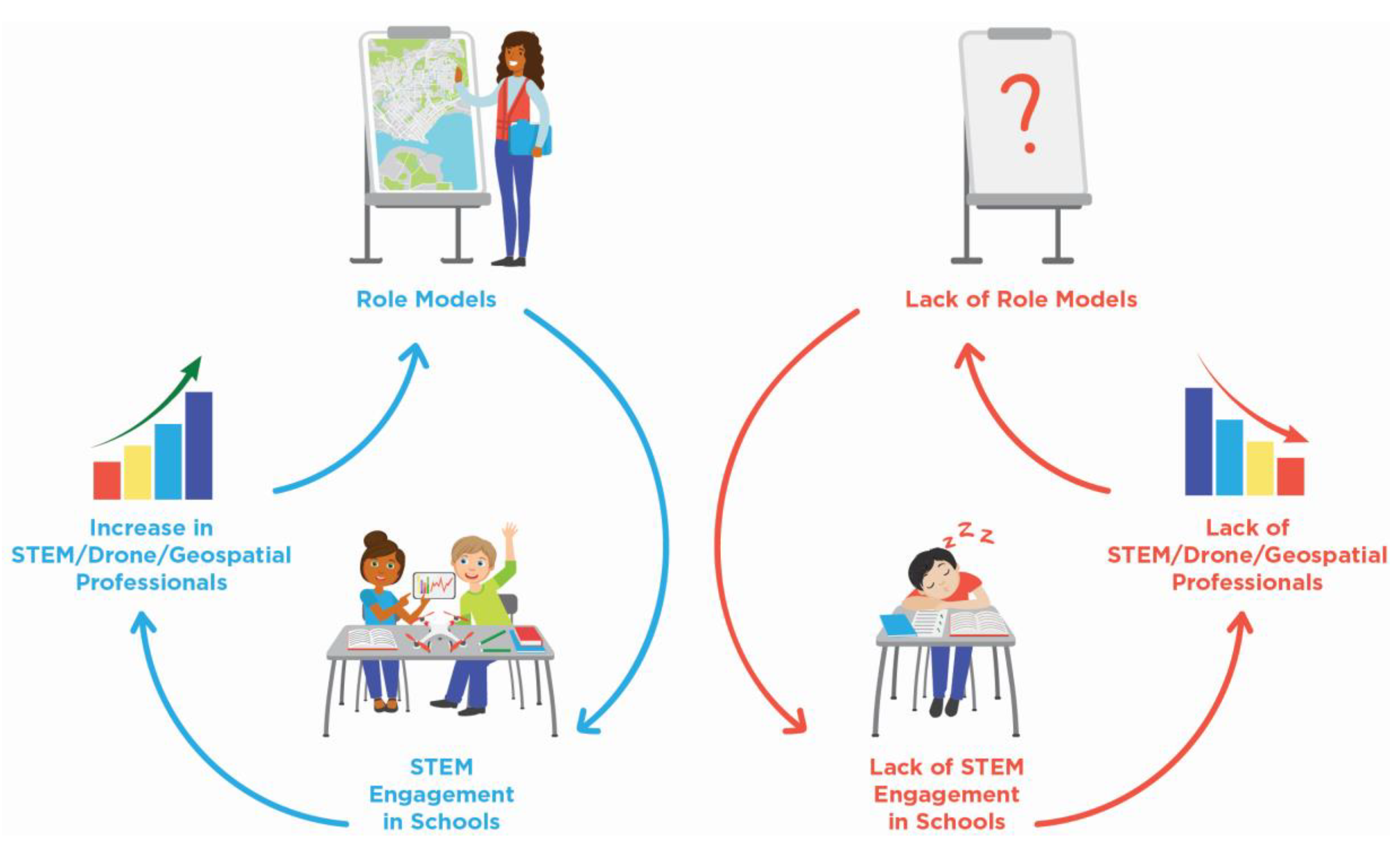
2. Contextual Background

The State Government of Queensland, Australia, is at the forefront of supporting the emerging drone industry. In 2017, they released their Drone Strategy, which calls for drones to be considered within the school curriculum and included within the Department of Education’s science, technology, engineering, and maths (STEM) programs [19]. The rationale for this is to prepare students for future workforce opportunities where this emerging technology is being used.
However, introducing drones into education programs needs to go beyond learning basic flight skills. While the drone itself may represent exciting technology and bring with it a thrill of flying, drones bring an opportunity to think more broadly about using technology to solve sophisticated challenges. Indeed, as automation technology develops over the coming years, we will see less need for manual drone pilot skills [20,21]. Instead, there will be an increasing requirement for analytical and data skills [22,23] around using drones as a tool to solve problems.
Using drone technology to solve problems also links with other state-based strategic interests. The Queensland Government’s Space Industry Strategy, released in 2020, positions drones as part of the earth observation sector, and a key component of growing Queensland’s aerospace industry [24]. The strategy further references the Department of Education’s STEM programs, and the need to build teacher capabilities, and engage more students in STEM learning. Fortunately, drone technology is one such area that inspires interest across a broad range of students [25,26].
With drones being positioned by government and industry in the earth observation sector, integrating geography skills into drone-based learning is crucial to ensuring that students develop relevant skills for the future. Geosciences has been identified as one of the three most important emerging and evolving disciplines, alongside nanotechnology and biotechnology [27]. However, the demand for a geo-enabled workforce is starkly contrasted with student enrolment [25]. Geography in the Australian Curriculum is classified under Humanities and Social Sciences, and runs the risk of being overlooked in the Queensland Governments call to include drone education under the STEM the curriculum. Through the Geography curriculum, students gain knowledge and understanding of the interconnectedness of people and environments, as well as consumer needs and economic drivers. This is overlaid with skills related to questioning, research, data analysis, evaluation, reflection, and communication. These are critical skills for the future workforce, and where drone-specific elements can be woven into the Australian Curriculum to provide engaging, real-world applications for students in the classroom.
Spatial thinking is a crucial skill for the future workforce, and the current curriculum’s dissociation of geography from the more heavily supported STEM subjects may be contributing to the lack of geospatial professionals. This may be addressed by better positioning STEM as a cross-curriculum learning opportunity, rather than in a siloed approach to subjects. A report by the Australian Council for Educational Research has voiced similar concerns that teaching school subjects in isolation from each other is not preparing students for work in the 21st century, where interdisciplinary skills will become increasingly required to address societal challenges [23].
Interdisciplinary teaching approaches often require students to identify a problem and generate a solution, and drones are one option for supporting these opportunities in an enjoyable way [28]. Such opportunities will hopefully support developing a future workforce with an emphasis on creating rather than just consuming technology [29]. With this in mind, we describe below the challenges faced when using drones as a learning support tool in schools to encourage geospatial and STEM thinking, as well as an approach we are currently using to overcome the challenges and provide exciting learning opportunities. We consider this from the perspective of a classroom teacher who is aiming to implement authentic drone education themselves, but also from the perspective of a drone professional who may wish to consider offering their industry experience as a role model to a local school.

3. The Challenges of Drones in Schools

There are two key areas of challenge to consider when bringing drones and other emerging technology into the classroom:
  • Skills and expertise of the classroom teacher; and
  • Understanding and implementing the regulatory framework, including developing appropriate risk management procedures.
Further, it is often difficult to address the regulatory framework in the absence of the appropriate skills and expertise of the teaching staff.

3.1. Teaching Expertise

A report by the Australian Council for Educational Research found that 26% of Grade 7–10 teachers and 15% of Grade 11–12 teachers were teaching out-of-field [30]. Teaching out-of-field is where qualified teachers are assigned subjects for which they have not studied above a first year at university, and have not studied the appropriate teaching methodology [31]. Without this experience, out-of-field teachers lack content knowledge as well as the correct pedagogical approach required to effectively engage the students in meaningful learning.
A key attribute of highly effective teachers is a thorough understanding of the subjects they teach [32]. Teaching subjects outside of their discipline knowledge reduces teacher competence, which has been directly linked to teacher burnout rates [33]. The impacts of out-of-field teaching are also directly related to low-quality student learning, and decreases in effective classroom management, impacting student engagement [34]. Geography and Information Technology (IT) have some of the highest rates of out-of-field teaching (40% and 34%, respectively) and maths and physics have out-of-field teaching rates of around 20% [30]. For teachers already struggling with the implications of out-of-field teaching and preparing lessons for subjects outside of their expertise, bringing drones and technology into the classroom can be a daunting task [35]. To help overcome these barriers, in this paper, we propose a framework for a standardised program to provide a step-by-step process of introducing drones into student learning, building industry standard skills, and creating future role models in the process (Figure 1).
From 1994–2012, there was a decrease in the number of students enrolling in intermediate to advanced mathematics (−12% and −6%, respectively), and decreases of 6–8% in participation in all science subjects except for earth science (+0.3%) [36]. In the absence of more recent data, it is unclear if this trend has further declined; however, Australia has seen a marked deterioration in student scores based on reading, mathematical and scientific literacy across all schooling levels according to the Programme for International Schools Assessment (PISA) [37]. These reports highlight the need for further support to be provided to teachers, if we are going to increase the number of students, with the right skills, and the right content knowledge, to join a STEM workforce.

3.2. Risk Management

In Australia, drones are governed by the Civil Aviation Safety Authority (CASA), and there are clear regulations around how they can be used, both indoors and outdoors. In other countries, using drones indoors is often not covered by the Federal aviation authorities. Teachers should therefore always research the specific government regulations around flying drones or minidrones in their school before planning to incorporate them into classroom activities.
In addition to federal regulations, teachers are required to undertake a risk identification process and mitigate risks in a similar way to other learning activities and programs. Flying minidrones within the confines of a school gymnasium or classroom is not without risk, but some basic mitigation strategies are simple to implement (Table 1).

4. Success with Drones in Schools—Our Approach

There are many different ways in which drone technology can be introduced to students. Here we describe the approach that we have used over the past three years to provide an immersive learning experience that is flexible enough to engage students of all ages. We introduce the interdisciplinary and real world tenets that are fundamental to STEM education and encourage students to conceptualise problems and design solutions with geospatial thinking, rather than button clicking [25,38].
Over the course of 2.5 h, we encourage students to imagine themselves as geospatial scientists and professional drone pilots first on the scene of an area impacted locally relevant natural disaster. They then use a minidrone (e.g., Parrot Mambo [39] or DJI Tello [40]) to capture data (photos) to document the extent of the damage to share with a hypothetical local authority. In ‘crew’ of three, they are given rotating roles of the pilot in charge, co-pilot, and chief reporter. These roles are designed to mimic job requirements on a mapping mission, and are deliberately incorporated so that students can imagine themselves as a scientist rather than concede to the common ‘white lab coat’ stereotype of the profession [41]. Together, the students work in their crews to conceptualise the problem and apply their knowledge to design a mapping solution, using experiential learning [42]. Importantly, all students are actively involved in flying and programming their drones, rather than passively observing (Figure 2).

4.1. Learning Framework around School Drone Program

The following components are ubiquitous to geospatial drone data capture missions, regardless of the specific scenario or equipment:
  • Safety check to consider the location (in conjunction with local regulations), personal protective equipment, and the drone with its accessories;
  • Create a flight plan (manual or autonomous) to ensure areas of interest are adequately captured in the detail required; and
  • Evaluate flight plan and data captured for quality and coverage.
Using the above components, we created activities that can be used across K-12 and tertiary education to introduce students to fundamental concepts of geospatial technology. Specific learning objectives and activities covered are age appropriate in three case study groups—elementary/primary; middle/secondary; and tertiary. The program is also mapped to the national curriculum standards in Australia.
We used Bloom’s Taxonomy [43] in our pedagogical approach to encourage learning that goes far deeper than the simple pleasure of flying. As any scientist who uses drones for data capture will attest to, the manual flight component of a project is miniscule when compared to the essential tasks of planning the mission and evaluating the data. With a problem-based learning approach, the program allows students to progress through the Taxonomy from remember to understand, apply, analyse, evaluate, and finally to the highest order to create new ideas, thoughts, and processes.
We designed the ‘real-world’ problem-based scenario specifically to exploit the benefits of collaborative community and create an authentic learning environment [29]. We scaffold the task with the drone mission components mentioned above:
  • Safety—All students regardless of age or education level are required to undertake a pre-flight safety check. Our safety checklist is freely available within the Epicollect5 mobile application by searching ‘minidrone’. We use this to guide students through a discussion about where and how to operate their drone safely and legally.
  • Flight Planning—We set up a large cloth floor mat of a satellite image in a local area. It is also possible to use Lego or similar to create the impacted township. Students review the area and sketch a conceptual design of their flight plan. They then use the mobile applications Tynker [44] (for Parrot Mambo), Tello EDU [45] or DroneBlocks [46] (for DJI Tello) to program their drone to conduct an autonomous mission and capture the data. It is also possible to use Scratch, Python, or JavaScript to program the drone.
  • Evaluate—Students evaluate how effective their code was in making the drone fly according to their mission, make adjustments to their plan, and re-fly if required.
In order for the program to be successful and challenging to students of varying ages and experiences, we have tailored aspects of the general framework accordingly. It is important to recognize that these activities can be undertaken by a confident classroom teacher, but we are also advocating for other scientists and industry professionals to use our framework to get involved with their local schools.

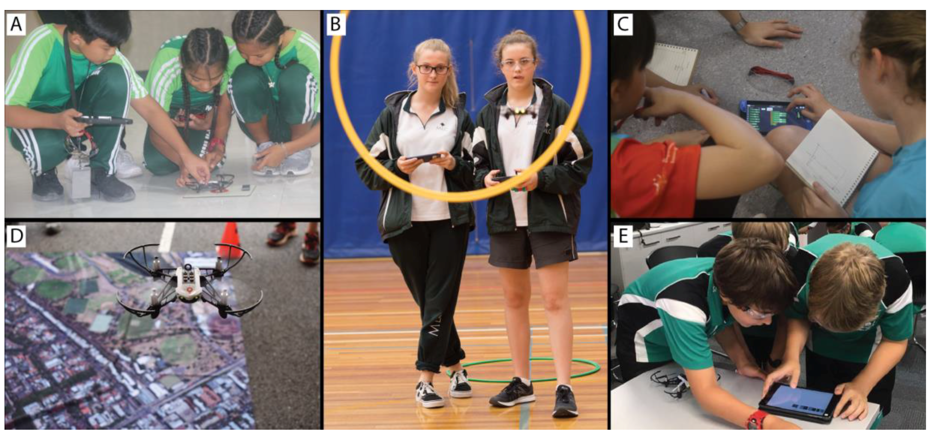
4.1.1. Elementary/Primary Education

Youngest students focus on personal safety and responsibility rather than federal aviation regulations. High adult to student ratios for supervision are also critical. We introduce block coding with upper primary/elementary students, and practice manual flight with the younger grades. Manual flight is used to improve fine motor skills and spatial visualization [28], as well as to ensure students begin to understand basic flight operations.

4.1.2. Middle/Secondary Education

Students in this age group are ready to see the link between using minidrones and drones that are better suited to capturing data under real-life scenarios. They can start to use more advanced text-based software programming for their mission planning (e.g., Python and Swift) as well as incorporating looping or repeat functions within their code. Programming skills are important within the digital technologies curriculum, and are also of great benefit to scientists more broadly for processing large datasets [47], so this is a good introduction. Students explore their mission planning solutions and the tradeoffs between area covered and spatial detail achieved when altering flight altitude.
In some cases, students may have access to a larger drone (or data captured from one) and we introduce basic GIS mapping analysis and show the link between the minidrone activities and ‘real world’ applications. One popular activity is to create an orthomosaic and digital surface model (DSM) of school grounds, and assess the amount of tree shade available (Figure 3). This allows students to explore their school campus from a new perspective, and also make recommendations to the school for ways to increase shady recreation space.

4.1.3. Tertiary Education

Tertiary students also explore the foundation learnings similar to younger students as per Section 4.1.1 and Section 4.1.2. However, we extend the focus to remote sensing and the capabilities of the sensor or payload on the drone. Students use the minidrone to calculate camera field of view, image swath width, and pixel resolution at any given flying height. This provides them with practical skills related to determining the spatial characteristics of data sets they may acquire. They are then required to synthesise this with their theoretical knowledge of spectral and temporal requirements of data capture, as well as necessary overlap and sidelap of photos within mission planning. This allows them to design an optimal data collection mission under a given scenario to resolve an environmental challenge.

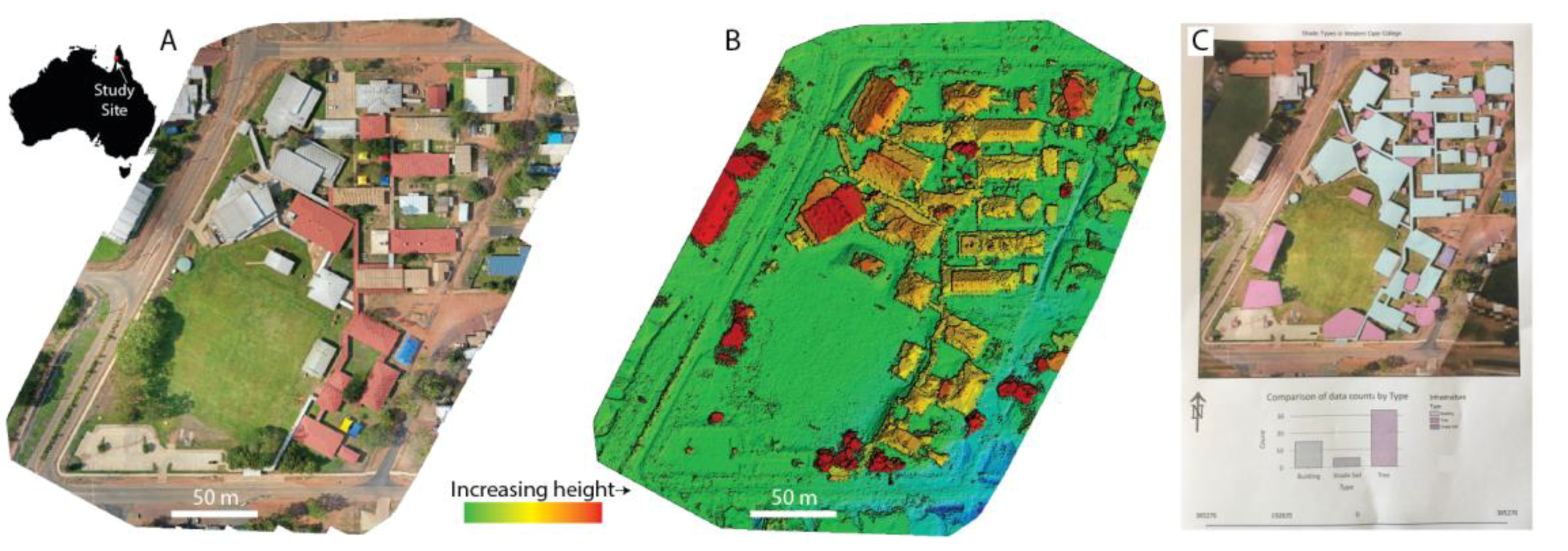
4.2. Evaluating School Drone Programs

To date, we have used the above approach to run in excess of 250 programs with more than 6000 participants in schools and community groups around Australia, the United Kingdom, the United States, and Indonesia. We have further trained local volunteers with drone or geospatial backgrounds based in Nepal, India, Tanzania, Panama, Fiji, Jamaica, Papua New Guinea, Senegal, United States, the Philippines, Mongolia, and Uganda who are able to apply the learning framework in their own context, in the local language. It is incredibly important to partner with volunteers from local communities to run this type of training for it to become a sustainable learning model [48]. Local scientists and industry representatives are familiar with the inherent challenges of their locations that they need to overcome [49], and also provide more authentic role models and learning experiences for local students.
We are, therefore, confident that the concepts and structure have a robust formula that can be replicated around the world to help build an interest and skills in drone and geospatial technology. Independent research conducted prior to, and following a subset of our programs indicated that more girls would consider STEM subjects in the future after participating in the program [50]. However, the authors also caution against labelling activities as ‘STEM’, as often this may only attract those students who are already predisposed to having an interest in that area. Therefore, it is important to show the range of exciting applications of drone technology to capture the attention of students with diverse interests and perspectives to offer the future workforce. More work is required to conduct a longitudinal study to determine the long-term impact of interventions and programs like this on students and their future career paths.

5. Conclusions

The rise of drones captured the attention and imagination of scientists around the world. It has also allowed us to put geospatial technology in the hands of students of all ages with a fun ‘toy’ as a learning support tool. We have used these minidrones to create a real-world, hands on STEM program to teach geospatial technology fundamentals with a problem-based learning approach. The framework of the program supports students to progress from basic knowledge and understanding through to synthesising ideas and creating new solutions. This program can be tailored to students across all age levels, from primary/elementary through to tertiary, and also for professional development training. As drones have the ability to be used for a variety of scientific, monitoring, and humanitarian purposes, we further encourage the program as a way to build local capacity in developing countries through training local community volunteers. The local connection is particularly important to provide authentic and sustainable learning opportunities in the local language, with local role models and relevant context. Through helping students to experience geospatial and drone technology in such a fun and interactive program, we hope to encourage a new wave of innovative geospatial scientists in the future workforce. We encourage other scientists who use drones as part of their research and operations to similarly reach out to their local schools to share their experiences, act as role models, and help increase diverse and inclusive representation in STEM.

Author Contributions

Conceptualization and development of the program detailed within: K.E.J.; Research and review: K.E.J., N.M., P.C.H.M., Writing: K.E.J., N.M., P.C.H.M. All authors have read and agreed to the published version of the manuscript.

Funding

This program was developed in part through support from an Australian Government Department of Industry, Innovation, and Science Women in STEM and Entrepreneurship grant to James Cook University (K.E.J) and a Queensland Government Advance Queensland Engaging Science grant to K.E.J.

Acknowledgments

We gratefully acknowledge the many students and educators around the world who have provided feedback to continue to strengthen the program and resources. Thank you to Nadia Joubert for assistance with graphics and to three anonymous reviewers for providing constructive feedback on an earlier version of the manuscript

Conflicts of Interest

The authors declare no conflict of interest.

References

  1. Murugan, D.; Garg, A.; Tasneem, A.; Singh, D. Fusion of Drone and Satellite Data for Precision Agriculture Monitoring. In Proceedings of the 11th International Conference on Industrial and Information Systems, Roorkee, India, 3–4 December 2016. [Google Scholar]
  2. Zarco-Tejada, P.J.; González-Dugo, V.; Berni, J.J.A. Fluorescence, temperature and narrow-band indices acquired from a UAV platform for water stress detection using a micro-hyperspectral imager and a thermal camera. Remote Sens. Environ. 2012, 117, 322–337. [Google Scholar] [CrossRef]
  3. Zarco-Tejada, P.J.; Guillén-Climent, M.L.; Hernández-Clemente, R.; Catalina, A.; González, M.R.; Martín, P. Estimating leaf carotenoid content in vineyards using high resolution hyperspectral imagery acquired from an unmanned aerial vehicle (UAV). Agric. For. Meteorol. 2013, 171, 281–294. [Google Scholar] [CrossRef] [Green Version]
  4. Lisein, J.; Linchant, J.; Lejeune, P.; Bouché, P.; Vermeulen, C. Aerial surveys using an unmanned aerial system (UAS): Comparison of different methods for estimating the surface area of sampling strips. Trop. Conserv. Sci. 2013, 6, 506–520. [Google Scholar] [CrossRef] [Green Version]
  5. Collin, A.; Ramambason, C.; Pastol, Y.; Casella, E.; Rovere, A.; Thiault LEspiau, B.; Siu GLerouvreur, F.; Nakamura, N.; Hench, J.L.; Schmitt, R.J.; et al. Very high resolution mapping of coral reef state using airborne bathymetric LiDAR surface-intensity and drone imagery. Int. J. Remote Sens. 2018, 39, 5676–5688. [Google Scholar] [CrossRef] [Green Version]
  6. Chirayath, V.; Earle, S.A. Drones that see through waves—Preliminary results from airborne fluid lensing for centimetre-scale aquatic conservation. Aquat. Conserv. Mar. Freshwater Ecosyst. 2016, 26, 237–250. [Google Scholar] [CrossRef] [Green Version]
  7. Casella, E.; Collin, A.; Harris, D.; Ferse, S.; Bejarano, S.; Parravicini, V.; Hench, J.L.; Rovere, A. Mapping coral reefs using consumer-grade drones and structure from motion photogrammetry techniques. Coral Reefs 2017, 36, 269–275. [Google Scholar] [CrossRef]
  8. Bennett, M.K.; Younes, N.; Joyce, K.E. Automating Drone Image Processing to Map Coral Reef Substrates Using Google Earth Engine. Drones 2020, 4, 50. [Google Scholar] [CrossRef]
  9. Gray, P.; Ridge, J.; Poulin, S.; Seymour, A.; Schwantes, A.; Swenson, J.; Johnston, D. Integrating Drone Imagery into High. Resolution Satellite Remote Sensing Assessments of Estuarine Environments. Remote Sens. 2018, 10, 1257. [Google Scholar]
  10. Mlambo, R.; Woodhouse, I.; Gerard, F.; Anderson, K. Structure from Motion (SfM) Photogrammetry with Drone Data: A Low Cost Method for Monitoring Greenhouse Gas. Emissions from Forests in Developing Countries. Forests 2017, 8, 68. [Google Scholar] [CrossRef] [Green Version]
  11. Wallace, L.; Lucieer, A.; Watson, C.; Turner, D. Development of a UAV-LiDAR System with Application to Forest Inventory. Remote Sens. 2012, 4, 1519–1543. [Google Scholar] [CrossRef] [Green Version]
  12. Clapuyt, F.; Vanacker, V.; Van Oost, K. Reproducibility of UAV-based earth topography reconstructions based on Structure-from-Motion algorithms. Geomorphology 2016, 260, 4–15. [Google Scholar] [CrossRef]
  13. Ambrosia, V.G.; Wegener, S.S.; Brass, J.A.; Hinkley, E. Use of Unmanned Aerial Vehicles for Fire Detection. In Proceedings of the 5th International Workshop on Remote Sensing and GIS Applications to Forest Fire Management: Fire Effects Assessment, Zaragoza, Spain, 16–18 June 2005; De la Riva, J., Pérez-Cabello, F., Chuvieco, E., Eds.; Universidad de Zaragoza: Zaragoza, Spain, 2005; pp. 9–17. [Google Scholar]
  14. Ambrosia, V.G.; Wegener, S.S.; Sullivan, D.V.; Buechel, S.W.; Dunagan, S.E.; Brass, J.A.; Stoneburner, J.; Schoenung, S.M. Demonstrating UAV-acquired real-time thermal data over fires. Photogramm. Eng. Remote Sens. 2003, 69, 391–402. [Google Scholar] [CrossRef]
  15. Maza, I.; Caballero, F.; Capitán, J.; Martínez-de-Dios, J.R.; Ollero, A. Experimental Results in Multi-UAV Coordination for Disaster Management and Civil. Security Applications. J. Intell. Robot. Syst. 2010, 61, 563–585. [Google Scholar] [CrossRef]
  16. Pla, M.; Duane, A.; Brotons, L. Potential of UAV images as ground-truth data for burn severity classification of Landsat imagery: Approaches to an useful product for post-fire management. Rev. Teledetec. 2017, 49, 91–102. [Google Scholar] [CrossRef] [Green Version]
  17. Laliberte, A.S.; Herrick, J.E.; Rango, A. Acquisition, orthorectification; object-based classification of unmanned aerial vehicle (UAV) imagery for rangeland monitoring. Photogramm. Eng. Remote Sens. 2010, 76, 661–772. [Google Scholar] [CrossRef]
  18. Joyce, K.E.; Duce, S.; Leahy, S.M.; Leon, J.; Maier, S.W. Principles and practice of acquiring drone-based image data in marine environments. Mar. Freshwater Res. 2019, 70, 952. [Google Scholar] [CrossRef]
  19. Queensland Government. Queensland Drones Strategy; Department of the Premier and Cabinet, Queensland Government: City East, QLD, Australia, 2018; p. 44. [Google Scholar]
  20. Frost & Sullivan. Drones: R&D Portfolio and Opportunity Analysis; Frost & Sullivan: Santa Clara, CA, USA, 2019. [Google Scholar]
  21. Interact Analysis. Commercial UAV Report 2017; Interact Analysis: Austin, TX, USA, 2017. [Google Scholar]
  22. Samuel, D. Big data: Teaching must evolve to keep up with advances. Nature 2008, 455, 461. [Google Scholar]
  23. Masters, G.N. Five Challenges in Australian School Education. In Policy Insights; Australian Council for Educational Research: Camberwell, Australia, 2015. [Google Scholar]
  24. Queensland Government. Queensland Space Industry Strategy 2020–2025; The Department of State Development, Infrastructure and Planning, Queensland Government: City East, QLD, Australia, 2020; p. 32. [Google Scholar]
  25. Fombuena, A. Unmanned Aerial Vehicles and Spatial Thinking: Boarding Education with Geotechnology And Drones. IEEE Geosci. Remote Sens. Mag. 2017, 5, 8–18. [Google Scholar] [CrossRef]
  26. Carnahan, C.; Crowley, K.; Hummel, L.; Sheehy, L. New Perspectives on Education: Drones in the Classroom. In Proceedings of the Society for Information Technology & Teacher Education International Conference 2016, Savannah, GA, USA, 21 March 2016; Chamblee, G., Langub, L., Eds.; Association for the Advancement of Computing in Education (AACE): Savannah, GA, USA, 2016; pp. 1920–1924. [Google Scholar]
  27. Gewin, V. Mapping opportunities. Nature 2004, 427, 376–377. [Google Scholar] [CrossRef]
  28. Chou, P.-N. Smart Technology for Sustainable Curriculum: Using Drone to Support. Young Students’ Learning. Sustainability 2018, 10, 3819. [Google Scholar] [CrossRef] [Green Version]
  29. Pulimood, S.M.; Wolz, U. Problem Solving in Community: A Necessary Shift in Cs Pedagogy; Association for Computing Machinery: New York, NY, USA, 2008; Volume 40, pp. 210–214. [Google Scholar]
  30. Weldon, P.R. Out-of-field Teaching in Australian Secondary Schools. In Policy Insights; Australian Council for Educational Research: Camberwell, Australia, 2016. [Google Scholar]
  31. McKenzie, P.; Weldon, P.; Rowley, G.; Murphy, M.; McMillan, J. Staff in Australia’s Schools 2013: Main Report on the Survey; Australian Government Department of Education: Canberra, Australia, 2014. [Google Scholar]
  32. Darling-Hammond, L.; Bransford, J.D. Preparing Teachers for a Changing world: What Teachers Should Learn and Be Able to Do; Jossey-Bass: San Francisco, CA, USA, 2005. [Google Scholar]
  33. Pillay, H.; Goddard, R.; Wilss, L. Well-being, Burnout and Competence: Implications for Teachers. Aust. J. Teach. Educ. 2005, 30, 22–33. [Google Scholar] [CrossRef] [Green Version]
  34. Du Plessis, A.E. Barriers to effective management of diversity in classroom contexts: The out-of-field teaching phenomenon. Int. J. Educ. Res. 2019, 93, 136–152. [Google Scholar] [CrossRef]
  35. Kelly, D.P. Overcoming Barriers to Classroom Technology Integration. Educ. Technol. 2015, 55, 40–43. [Google Scholar]
  36. Kennedy, J.; Lyons, T.; Quinn, F. The continuing decline of science and mathematics enrolments in Australian high schools. Teach. Sci. 2014, 60, 34–46. [Google Scholar]
  37. Thomson, S.; De Bortoli, L.; Underwood, C.; Schmid, M. PISA 2018: Reporting Australia’s Results. Volume I Student Performance; Australian Council for Education Research, Australian Government Department of Education: Canberra, Australia, 2018. [Google Scholar]
  38. Gomez, A.; Albrecht, B. True Stem Education. Technol. Eng. Teach. 2014, 73, 8–16. [Google Scholar]
  39. Parrot Drones SAS. Parrot Mambo Quick Start Guide. 2019. Available online: https://www.manualslib.com/manual/1296161/Parrot-Mambo.html (accessed on 15 September 2020).
  40. Ryze Tech. Tello User Manual v1.2. 2018. Available online: https://www.ryzerobotics.com/ (accessed on 19 August 2020).
  41. Howes, E.V.; Cruz, B.C. Role-Playing in Science Education: An. Effective Strategy for Developing Multiple Perspectives. J. Elem. Sci. Educ. 2009, 21, 33–46. [Google Scholar] [CrossRef]
  42. Kolb, D.A. Experiential Learning: Experience as the Source of Learning and Development; Prentice-Hall: Englewood Cliffs, NJ, USA, 1984; p. 256. [Google Scholar]
  43. Bloom, B.S. Taxonomy of Educational Objectives, Handbook I: The Cognitive Domain; Addison-Wesley Longman Ltd.: New York, NY, USA, 1956. [Google Scholar]
  44. Neuron Fuel Inc. Tynker (Version 3.12.25) [Mobile Application Software]. 2018. Available online: https://www.tynker.com/mobile/ (accessed on 19 August 2020).
  45. Winstron Infocomm Corporation. Tello EDU (Version 1.5.4) [Mobile Application Software]. 2018. Available online: https://www.ryzerobotics.com/tello/downloads (accessed on 19 August 2020).
  46. Baldwin, D. DroneBlocks (Version 2.6) [Mobile Application Software]. 2019. Available online: https://www.droneblocks.io/app/ (accessed on 19 August 2020).
  47. Younes Cárdenas, N.; Joyce, K.E.; Maier, S.W. Monitoring mangrove forests: Are we taking full advantage of technology? Int. J. Appl. Earth Obs. Geoinf. 2017, 63, 1–14. [Google Scholar] [CrossRef] [Green Version]
  48. Ika, L.A.; Donnelly, J. Success conditions for international development capacity building projects. Int. J. Proj. Manag. 2017, 35, 44–63. [Google Scholar] [CrossRef]
  49. Harris, E. Building scientific capacity in developing countries. EMBO Rep. 2004, 5, 7–11. [Google Scholar] [CrossRef]
  50. Petray, T.; Doyle, T.; Howard, E.; Morgan, R.; Harrison, R. Re-Engineering the “Leaky Pipeline” Metaphor: Diversifying the Pool by Teaching STEM “by Stealth”. Int. J. Gend. Sci. Technol. 2019, 11, 20. [Google Scholar]
Figure 1. Introducing drone technology into the classroom via structured programs may increase STEM participation in schools, leading to an increase in these skills in the future workforce, and creating role models to inspire the next generation of students. This positive spiral has the potential to rapidly grow the industry. Without an intervention or appropriate upskilling for teachers, the downward spiral may be realised.
Drones 04 00057 g001
Figure 2. Students work in ‘crew’ to (A) conduct safety checks on their drone with an predefined checklist on their tablet; (B) practice manual flight skills; (C) design a mapping solution with corresponding block coding to survey a hypothetical natural disaster site; (D) test their code over the survey site, represented by a satellite image printed on a 2 × 2 m cloth mat; and (E) evaluate their results.
Drones 04 00057 g002
Figure 3. Students capture drone data to create and analyse (A) an orthomosaic; (B) digital surface model (DSM); and (C) map of their school campus for the purpose of calculating the amount of tree shade.
Drones 04 00057 g003
Table 1. Risk Assessment for using drones in schools.
HazardLikelihoodConsequenceMitigation Strategies
Damage to eyes from propeller bladesLowPersonal injury including loss of vision Flying in an appropriate spacious location
Wearing safety or prescription glasses
Having a designated ‘flight zone’ and ‘safe zone’
Ensuring students are aware of signal to land
Ensuring students do not enter ‘flight zone’ whilst any drones are airborne
Outlining importance of safety checks following a crash to ensure propellers are properly attached
Classroom management procedures
Damage to skin from propeller bladesLowPersonal injury including cuts, abrasions, blood loss.Flying in an appropriate spacious location
Having a designated ‘flight zone’ and ‘safe zone’
Ensuring students are aware of signals requiring them to land
Ensuring students do not enter ‘flight zone’ whilst any drones are airborne
Removing batteries from drones when not in use
Classroom management procedures
Damage to overhead property (e.g., fans, projectors, etc)LowFinancial loss from replacing equipment
Drone falls from height onto student who may suffer personal injury
Flying in an appropriate spacious location
Limiting flying height to shoulder level
Retracting overhead obstructions where possible (nets, hoops, etc)
Classroom management procedures
Fire or explosions from lithium batteriesLowPersonal injury
Damage to property
Removing batteries from drones when not in use
Storing batteries in a cool, dry location inside a lithium storage bag when not in use
Only charging batteries when persons are present to observe
Damage to drones or tabletsModerateFinancial loss from replacing equipment or partsFlying in an appropriate spacious location
Classroom management procedures

