Article

Hemeroby Mapping of the Belém Landscape in Eastern Amazon and Impact Study of Urbanization on the Local Climate

by
Leonardo Seabra Furtado
1,
Raimundo Vitor Santos Pereira
2 and
Everaldo Barreiros de Souza
1,2,*
1
Instituto de Geociências, PPG-Ciências Ambientais, Universidade Federal do Pará, Belém 66075-110, Pará, Brazil
2
Faculdade de Meteorologia, Instituto de Geociências, Universidade Federal do Pará, Belém 66075-110, Pará, Brazil
*
Author to whom correspondence should be addressed.
Urban Sci. 2024, 8(1), 15; https://doi.org/10.3390/urbansci8010015
Submission received: 9 October 2023 / Revised: 4 January 2024 / Accepted: 9 January 2024 / Published: 9 February 2024
(This article belongs to the Topic Urban Land Use and Spatial Analysis)

Abstract

:
This work contributes to the studies on landscape mapping induced by human pressure directly related to the urbanization process, whose approach is based on the concept of hemeroby adapted to the metropolitan area of Belém in the eastern Amazon. The mapping results using 1985 and 2021 Landsat satellite data indicated that the artificial coverage characterized as medium to the high urban system (polyhemerobic and metahemerobic degrees) has increased by almost 17% toward northern districts and Outeiro/Mosqueiro islands, while the natural vegetation cover suppression (ahemerobic degree) was around 11%. In addition, we investigated the impacts of urban expansion on seasonal (WET from January to April and DRY from July to November) surface air temperature (minimum TN and maximum TX) patterns. From statistical comparisons between 18-year samples (2004/2021 to 1985/2002), we find evidence of a current significantly warmer climate, with a notable indication of higher surface temperature over densely urbanized areas compared to lower values over natural areas. In the TX climatology, particularly for the DRY regime, we identified a pattern similar to the classic heat island model with concentric isotherms reaching a maximum center over the more urbanized continental region of Belém and a thermal decrease at the edges. Therefore, the findings of this work are convincing that Belém already faces the direct impacts of urbanization on the local climate, so it is crucial to develop government strategies aimed at taking action to mitigate socioenvironmental risks and threats to the well-being of urban populations.

1. Introduction

Human actions on the environment, intrinsically linked to economic, social, and cultural factors, cause disturbances capable of altering the pre-existing ecosystem. The multiple human activities exerting pressure on natural landscapes, especially within metropolitan areas, can be considered the most serious form of environmental anthropization due to the intense and systematic changes in land use and land cover (LULC) [1,2]. Among the most relevant anthropogenic effects during the urbanization process we can mention the suppression of natural vegetation with loss of biodiversity, soil sealing, air and water pollution, and the direct impact on local climate [3].
The spatiotemporal modifications or transformations induced in the soil and surface cover in a given region or ecosystem, mainly through collective processes of anthropogenic origin and/or even through natural succession processes, can be investigated objectively through remote sensing techniques, which determine LULC classes ranging from the most preserved (natural) to the most modified (artificial) areas [4]. Here we will use an approach to studying LULC changes based on the hemeroby concept, whose term originates from landscape ecology and means “distance from nature”, being used to estimate human action on the environment [5]. The Finnish botanist Jalas was a pioneer in inserting this term into ecological components, dividing landscapes into four hemerobic degrees [6]; however, the original approach required constraints linked to vegetation regulation capacity, which in a certain way limited the application of the technique in urban areas. Thus, several authors expanded the study of hemeroby within the scope of LULC, considering a broader classification of seven to ten categories to evaluate the intensity of human interference in nature [7,8,9,10]. The distance between an eminently natural landscape (without human impact) and an artificial one (resulting from intense and systematic human impact) is indicated by the land use class containing the lowest and highest hemerobic degree, respectively. So, in regions presenting higher degrees of hemeroby, adverse effects on the natural flora and fauna components and physical conditions are expected, such that hemeroby is an important landscape mapping tool in studies of environmental changes [8].
In Brazil, the hemeroby technique was used as an environmental monitoring tool to evaluate landscape units in a district of Fortaleza in the state of Ceará located in the Northeast region [11], in a study to better understand the dynamics of the urban landscape of the Pinhais municipality in the state of Paraná in the South region [12], and in a multitemporal analysis of the naturalness loss of a watershed in the Cerrado biome near São Carlos region in the state of São Paulo in the Southeast region [13]. For the North region, which covers the Amazonian states, Gusmao [14] reported a landscape hemeroby study in the Immediate Geographic Region encompassing fifteen municipalities in the state of Pará. Based on the geoprocessing of images provided by the MapBiomas platform [4,15], these authors showed a moderate degree of human intervention in the landscapes of the studied municipalities, such that pasture cover was the class that contributed most strongly to soil changes in the comparison between 1985 and 2018 [14]. Also based on the analysis of MapBiomas thematic maps, Gutierrez [16] investigated LULC changes in the domain of the seven main cities belonging to the metropolitan region of Belém, whose specific results for the Belém municipality indicated that, from 1985 to 2020, the greatest environmental transformations were processed in the forest (decrease of 4.6%) and urban (increase of 4.4%) classes.
Here, we will conduct an application of hemeroby as a remote sensing mapping technique to analyze the intensity of changes in the structure of the landscape resulting from human activities over the municipality of Belém. This city is located at the mouth of the Amazonian basin, where the first frontier of human occupation occurred in the eastern Amazon. Belém is the second most populous city in the North region (after Manaus in the central Amazon) and occupies the twelfth position out of 27 Brazilian capitals [17]. This study aims to refine the LULC mapping studies with a focus on the continental area of the municipality of Belém, seeking to answer the following research questions: (1) In terms of landscape units, is it possible to extend the artificial classes of urban coverage induced by human action? What is the direction and intensity of the spatial expansion of these artificial classes? (2) What is the magnitude of the direct impact of urban expansion on seasonal air temperature patterns (maximum and minimum) in recent decades? Considering the interaction between climate and surface environment, do more urbanized areas have linearly higher air temperature values compared to preserved natural areas? To answer these relevant questions in the context of integrated scientific knowledge of climate and environment within Amazonian territory, we use the hemeroby method, which has two LULC classes (MapBiomas has only one) representing areas with urban artificiality structure. Considering that the Amazon climate’s intrinsic and fundamental characteristic is its pronounced seasonality [18], the climate impact study addresses the two seasonal regimes that correspond to the rainy/milder air temperature and the dry/warmer period throughout the year.
The literature is replete with studies of the effects or impacts of urbanization on the local climate in cities of different sizes around the world [19,20], and usually, the works were concerned with descriptions and findings based on empirical evidence and common sense [21]. Despite the low density of meteorological station networks in Brazil that limits the use of in situ historical data, the increasing availability of data estimated by various environmental satellites has allowed notable progress in quantitative scientific research on urban climatology [22]. Since Lombardo’s [23] pioneering work for the megacity of São Paulo, numerous studies have proven the systematic increase in surface air temperature associated with the urbanization process triggered in most state capitals spread from north to south of the Brazilian territory [24]. Likewise, here we report a contribution to the studies on the spatiotemporal characterization of the urbanization process and its impacts on seasonal thermal patterns along the metropolitan surface of Belém in the eastern Amazon.
A list of acronyms and abbreviations is provided in Appendix A to help in reading this work.

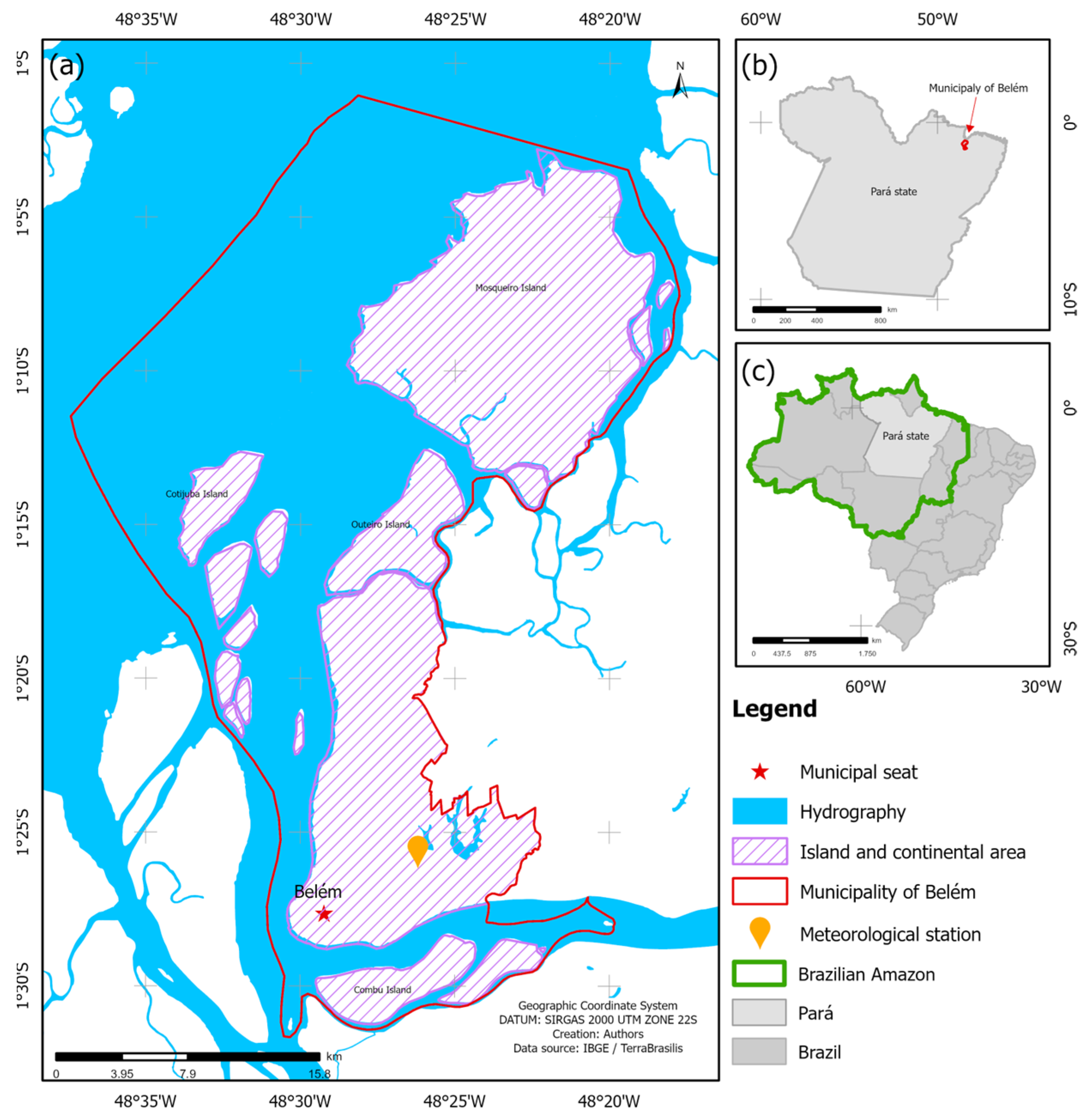
2. Materials and Methods

Figure 1 exhibits the study area encompassing the municipality of Belém, the capital of the state of Pará in the Brazilian eastern Amazon (see reference maps on the right in Figure 1). The geographic domain of the municipality is indicated by the red line in Figure 1a, with a total area of 1059 km2 for a population of about 1.3 million inhabitants and a demographic density of 1230 inhabitants per km2 [17]. Disregarding the extensive hydrographic portion (the Guajará Bay and Guamá river bordering the municipality from north to south), the continental area (hatched area in Figure 1a), including smaller islands to the south and the larger islands to the north, Cotijuba, Outeiro, and Mosqueiro, has a dimension of approximately 509 km2. As already mentioned, the focus of this work will be on Belém continental.
We used the surface air temperature (minimum TN and maximum TX) data collected in situ by the conventional meteorological station that was obtained from the Instituto Nacional de Meteorologia (INMET) of Brazil through the data portal https://bdmep.inmet.gov.br (accessed on 1 November 2022). This is the only station in the study area with the availability of complete meteorological data (all surface variables) and a consistent historical series for climatological studies. The station location (latitude −1.436, longitude −48.437, and altitude 7.13 m) is given by the orange symbol in Figure 1a, and the monthly data series are available from January/1985 to December/2021. In addition, we used observational TN and TX data derived from CRU-TS 4.06 (Climatic Research Unit gridded Time Series, compiled by [25]) that were downscaled with WorldClim 2.1 [26] into a horizontal grid with 0.041° or 4.5 km spatial resolution that is suitable for spatial analyzes at the municipal scale. CRU-TS was generated by the interpolation of monthly variables from extensive networks of weather station observations over all land domains of the world. Monthly time series from 1985 to 2021 (Geotiff data are available at www.worldclim.org/data/monthlywth.html, accessed on 1 December 2022) were extracted for the study area.
The hemeroby analysis used in this work is based on adaptations of the evaluation proposal formulated by [8] for regions with European landscapes (Germany), which were adapted to the landscape of a metropolitan area located in the eastern Amazon. Thus, the degree of anthropic impact on the continental landscape of the municipality of Belém was assessed by using an ordinal scale ranging from the lowest degree (ahemerobic class, indicating an area with zero or no human interference, i.e., a region considered natural) to the highest degree (metahemerobic class, representing an intensely anthropized area with maximum human interference, i.e., an artificial region), as described in Table 1. For a better understanding and realistic visualization of the landscape associated with the seven hemeroby degrees, Figure 2 illustrates the main surface environmental characteristics present in the region, in which the LULC classes representing the human interference were properly adapted to the study area (Table 1, last column on the right).
The processing and georeferencing were executed in the software QGIS 3.30.1 [27], adopting the Universal Transverse Mercator (UTM) projection system, the SIRGAS2000 Datum, and zone 22S. Land use dynamics were based on Landsat-5 (TM) and Landsat-8 (OLI) images with 30 m resolution, provided by the United States Geological Service (USGS) for the years 1985 and 2021, respectively. Then, a GeoTiff 1 km mesh was created over the Belém domain, and we carried out a multispectral composite of three RGB bands to classify the land use typologies based on criteria of texture, tone, and context of the satellite images collected in those two years. After computational training and supervised classification of the images, each polygon of surface cover was related to a previously hierarchical level of LULC class, according to the seven hemeroby degrees described in detail in Table 1 and Figure 2. To improve our LULC classification, some random validation points were made through fieldwork, expert judgment, and computational tools with Google Earth. In the end, the Kappa coefficient was calculated, which allowed us to evaluate the accuracy of mapping results on a scale of 0 (no agreement) to 1 (perfect agreement). The choice of 1985 as the initial year and 2021 as the final year is justified by the intention to compare our results with a similar study by [16]], who used the Mapbiomas platform. We reproduced these LULC-themed maps of this platform, which has only four main coverage classes: forest, non-forest natural formation, agriculture, and non-vegetated area [15].
Since seasonality in the Amazon is a relevant factor, to study the impact of urbanization on climate, we calculated TN and TX temporal series for WET (consecutive months from January to April) and DRY (successive months from July to November) seasonal means, whose periods were defined in the climatological studies documented by [16,18]. TN and TX data for in situ Belém station were statistically (calculation of Pearson correlations and scatterplot with the coefficient of determination R2) compared to CRU data (nearest gridpoint), with the purpose of validation and demonstrating that this gridded base is consistent and suitable for the air temperature spatial patterns analysis throughout the municipality of Belém.
The climatological maps (1985 to 2021 historical mean) of TN and TX were generated for the WET and DRY seasons. We also consider separately the two 18-year averages (1985/2002 and 2004/2021) to calculate the difference between samples and to a subsequent evaluation of spatial changes (in °C) in each seasonal regime. The gridded CRU data were georeferenced to the 2021 hemeroby map, and thus, two distinct sets containing the TN and TX time series representative of the gridpoints containing the urbanized artificial class and the natural forest class were obtained. We established a set of twelve points representative of the artificial areas and another set of seven points in natural areas (the map illustrating these grid points is shown in the results item). Descriptive statistics and Boxplot plotting have been used in these specific data sets, aiming to conduct quantitative analysis and ascertain whether most artificial districts and areas have significantly higher air temperatures compared to natural areas in the continental Belém. In these comparative analyses, the Student’s t-test with a level of 5% (p-value < 0.05) was considered to confirm whether the difference between the artificial and natural areas is statistically significant.

3. Results

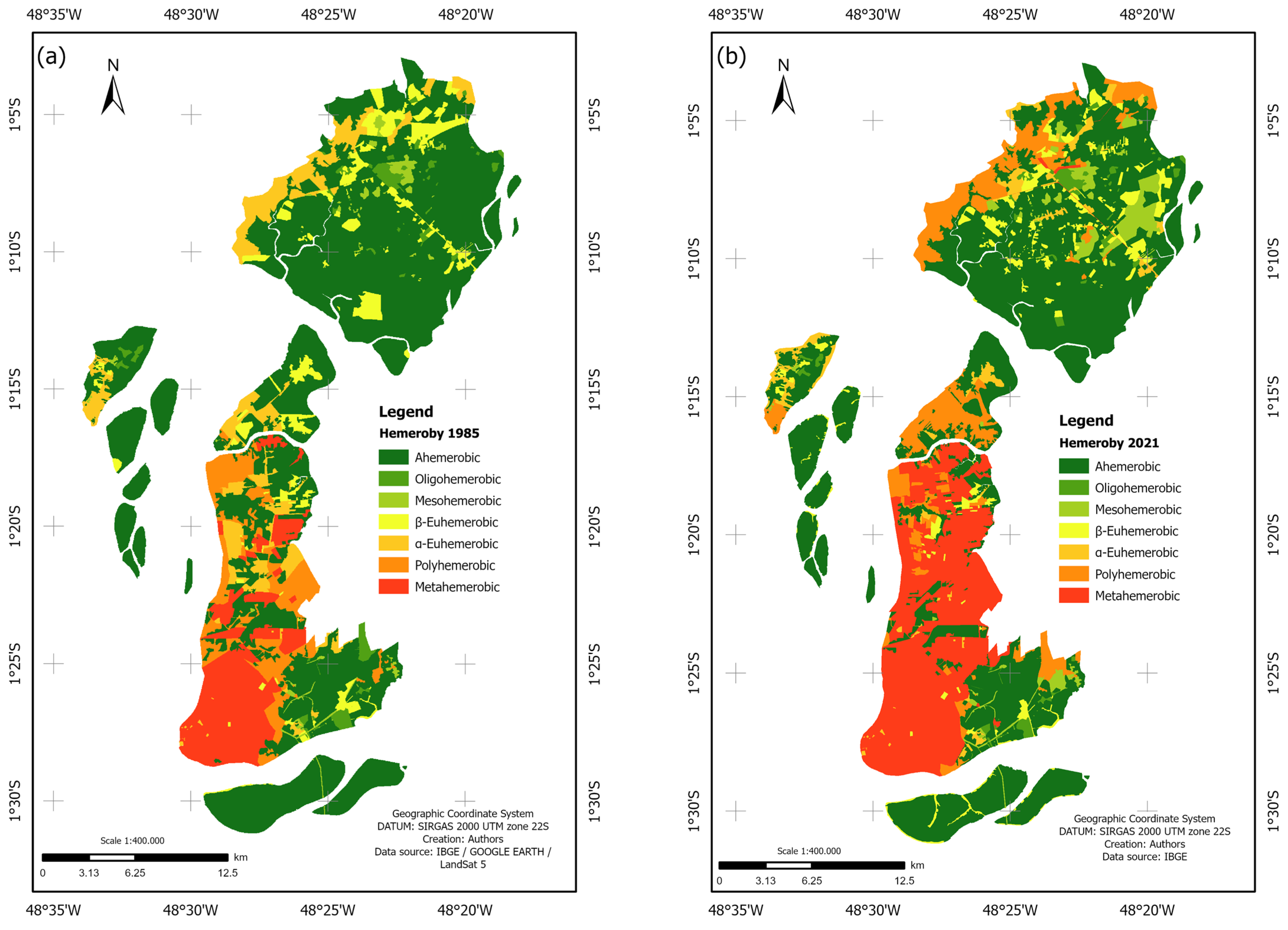
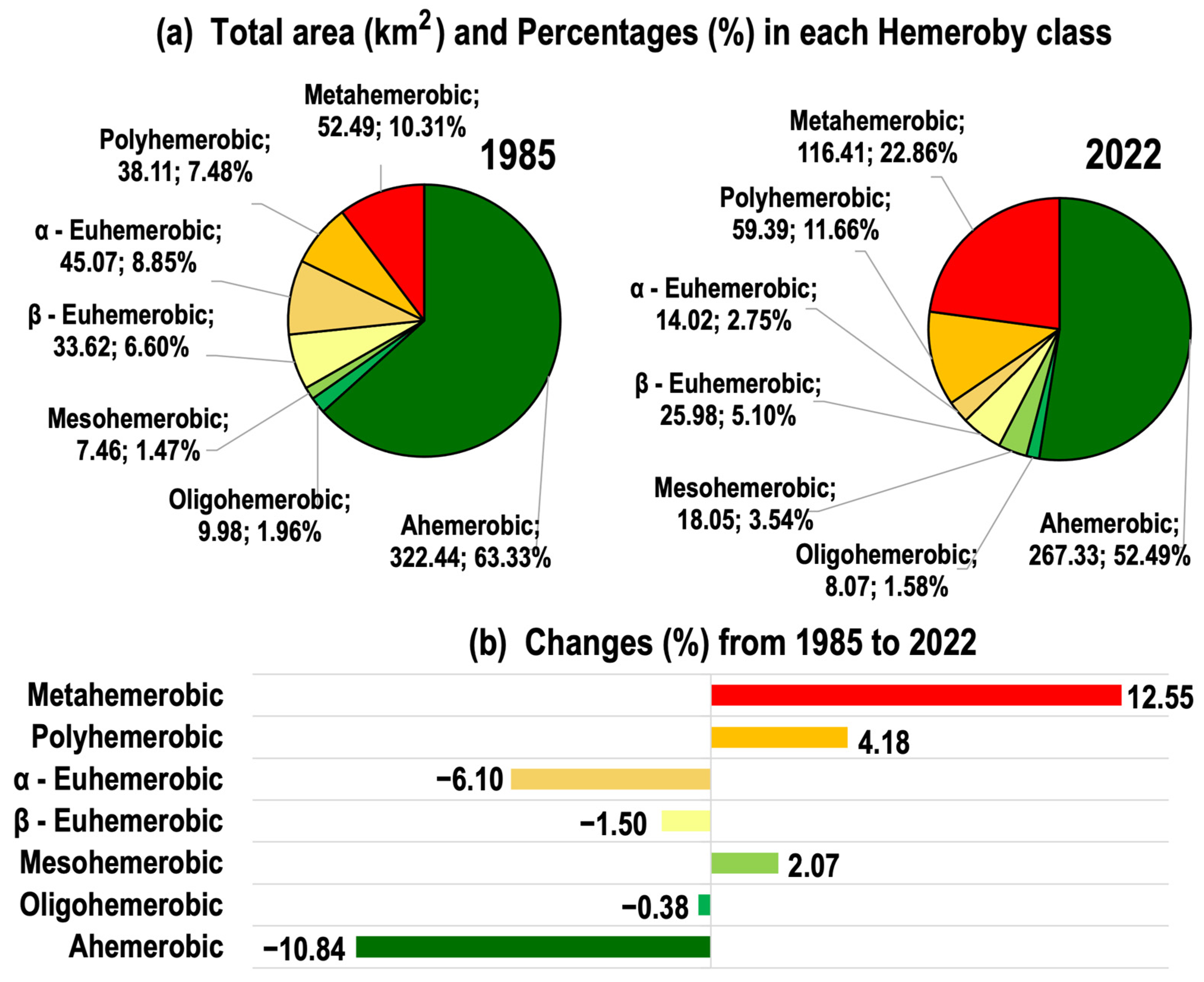
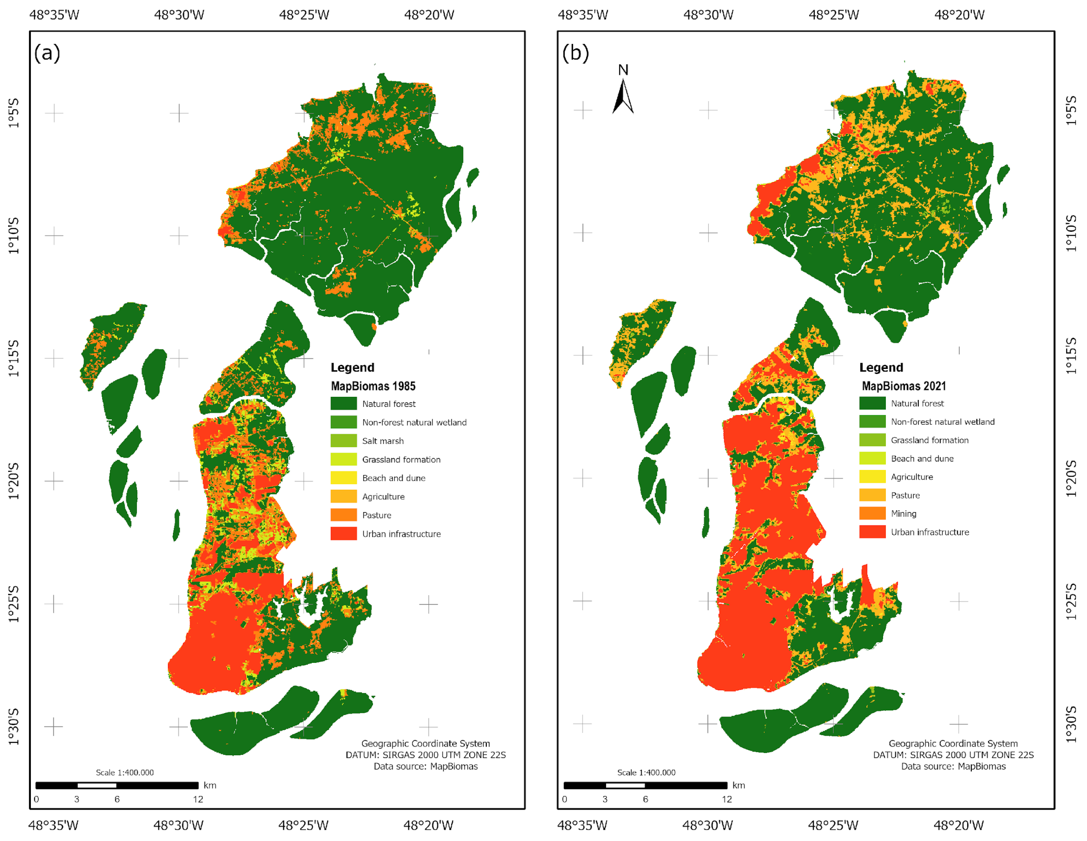
3.1. LULC Mapping Using Hemeroby Degree

In analyzing the accuracy of digital mapping through the kappa value, we obtained 0.928399 for the year 1985 and 0.950106 for 2021, indicating that the results presented significant agreement and high quality in the hemeroby maps generated for the municipality of Belém.
Figure 3 shows the hemeroby maps over the continental portion of Belém. In 1985, the initial year of analysis, the southernmost continental area of Belém (first patrimonial league) already had densely urbanized coverage, as indicated by the metahemerobic class. In this period, the polyhemerobic and α-euhemerobic classes, which correspond to medium and low urban density, respectively, are dominant in the central and northern portions of the municipality and throughout the western coastal strip of the island of Mosqueiro in the extreme north of the region. Concerning the areas of natural vegetation represented by the oligohemerobic and ahemerobic classes, they stand out on the small islands to the south and west, as well as in the southeastern continental portion of Belém and most of the island of Mosqueiro (Figure 3a). Examining the hemeroby map for the year 2021 and making a visual comparison with the 1985 map, we can notice a certain preservation of natural coverage (primary forests, secondary vegetation, and wetlands) restricted to the continental sector southeast of Belém in the small islands to the south and west, as well as a large part of the island of Mosqueiro, where the ahemerobic and oligohemerobic classes prevail. Particularly in the most preserved green area in southeast Belém, there were no major long-term transformations due to the Pará State government having created in 1993 the Utinga State Park Conservation Unit (USPCU) and the Environmental Protection Area of the Metropolitan Region of Belém (EPAMRB). These protected areas are essential for the public water supply to all municipalities in the metropolitan area [28]. Conversely, the expansion of the metahemerobic class over the central and northern sectors of the municipal seat is notable, indicating that the intense and disorderly process of urbanization (completely artificial landscape) now occupies the entire continental area of Belém and the adjacent island of Outeiro (Figure 3b).
The hemeroby mapping in the Belém region is consistent with the results of the LULC dynamics conducted by [16] that used the MapBiomes database, reproduced in Figure A1 in Appendix A of the present work. Both the 1985 and 2021 maps show that the spatial configuration of the areas with the artificial metahemerobic class indicating a dense urban system (Figure 3) coincides with the areas of the MapBiomes urban infrastructure class in Figure A1. Similarly, the areas highlighting the ahemerobic natural class in Figure 3 are consistent with areas in the MapBiomes natural forest class in Figure A1.
The quantitative results of the environmental transformations denoted by the hemeroby mapping by comparing the years 1985 and 2021, over three and a half decades, are shown in Figure 4, with pie charts showing the area in km2 and respective percentage in each class (Figure 4a), as well as the percentage changes observed in the period (Figure 4b). The most significant changes were observed in the extreme classes representing natural (ahemerobic) and totally artificial (meta-hemerobic) areas, i.e., the area with primary forest cover varied from 322.44 km2 (63.33%) in 1985 to 267.33 km2 (52.49%) in 2022, while the densely urbanized area expanded from 52.49 km2 (10.31%) in 1985 to 116.41 km2 (22.86%) in 2021 (Figure 4a). Thus, a suppression of the ahemerobic class of 10.84% and an expansion of the metahemerobic class of 12.55% was evidenced (Figure 4b). The polyhemerobic class representing urban coverage with medium intensity also increased from 38.11 km2 (7.48%) in 1985 to 59.39 km2 (11.66%) in 2022, signaling an enlargement in the period of 4.18%. The α-euhemerobic class (urban coverage with low intensity) fluctuated negatively from 45.07 km2 (8.85%) in 1985 to 14.02 km2 (2.75%) in 2022, with a variation in the period of −6.10%. The areas with the remaining classes β–euhemerobic, mesohemerobic, and oligohemerobic indices showed smaller variations, with changes in the period of −1.50%, 2.07%, and −0.38%, respectively.

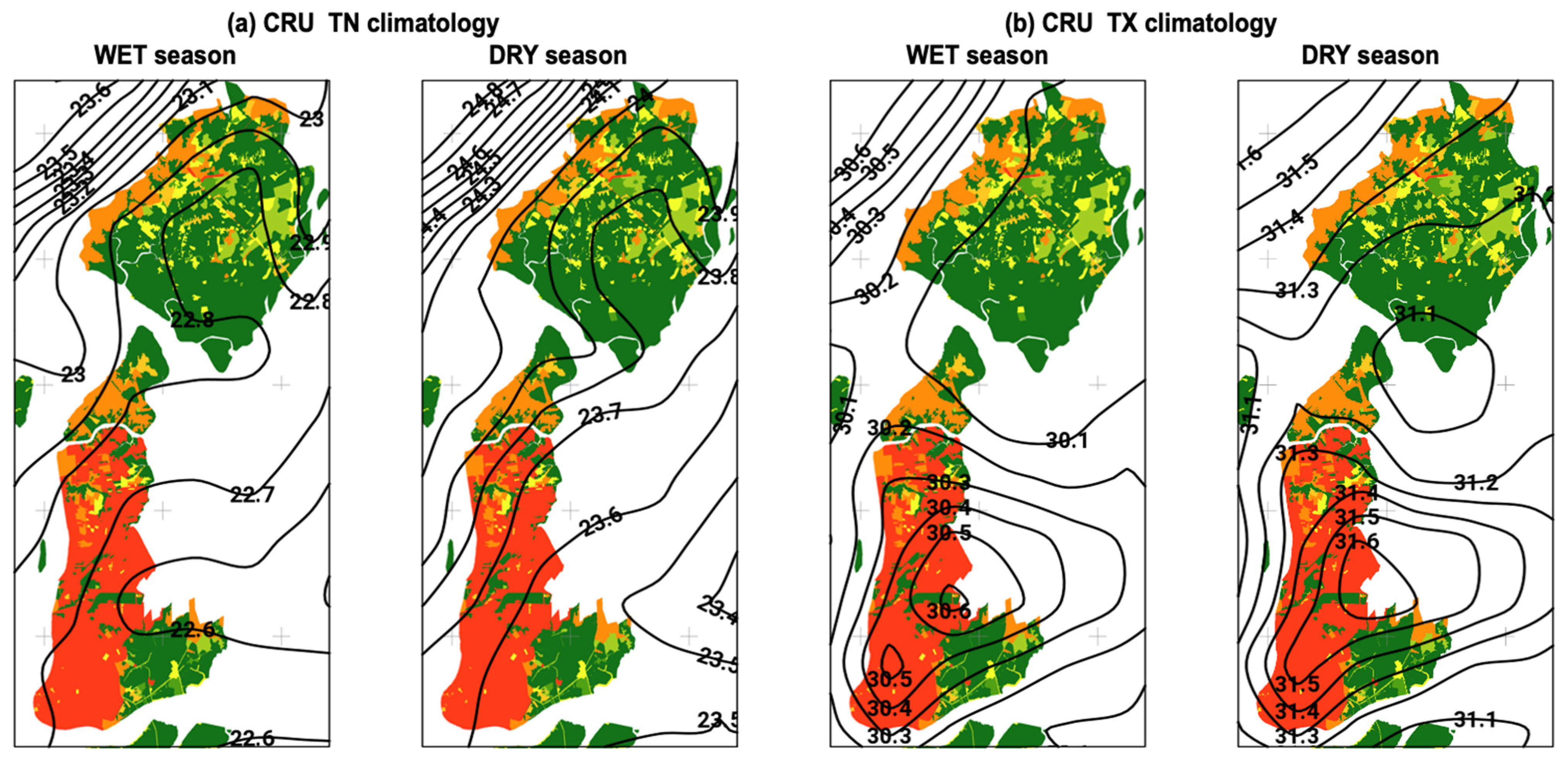
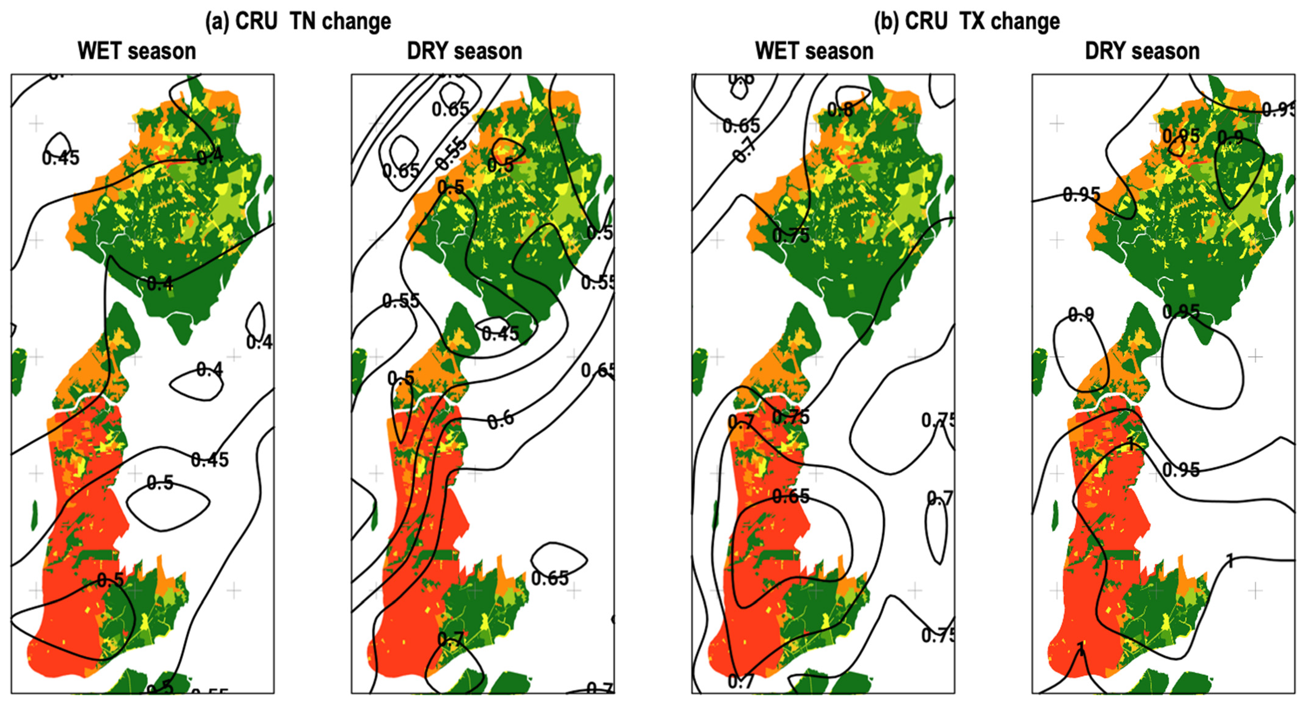
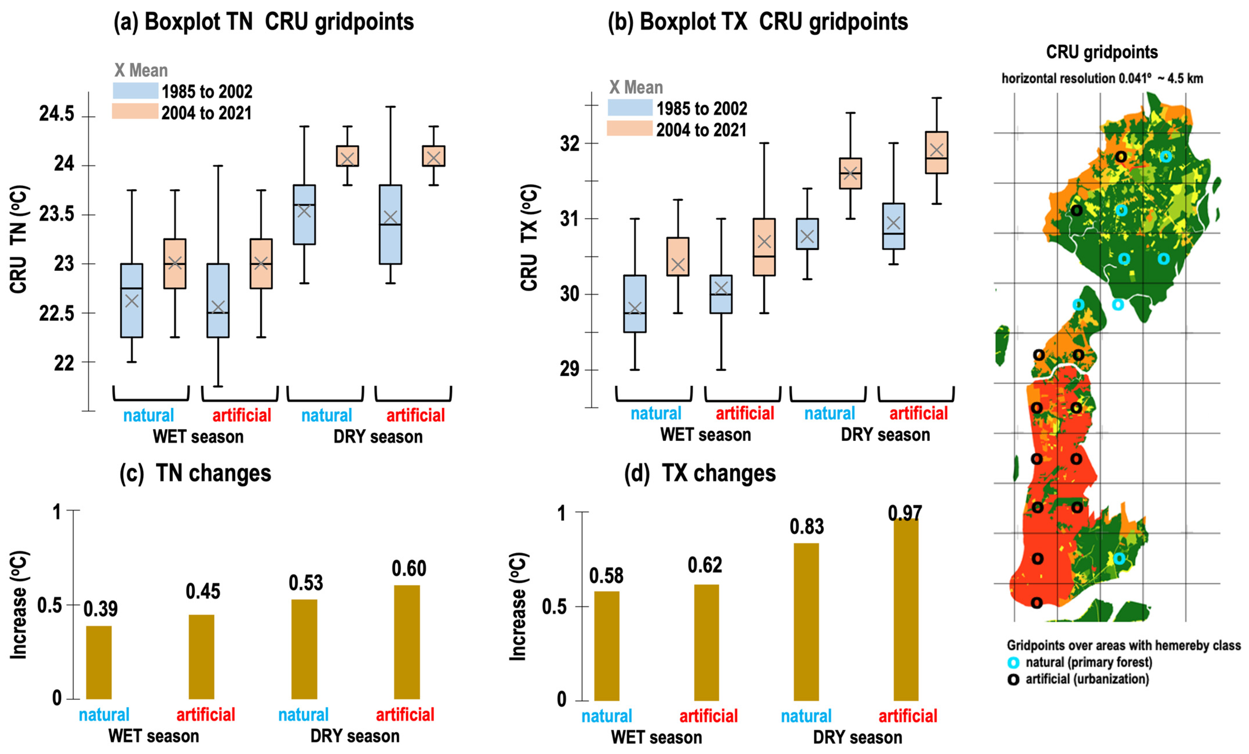
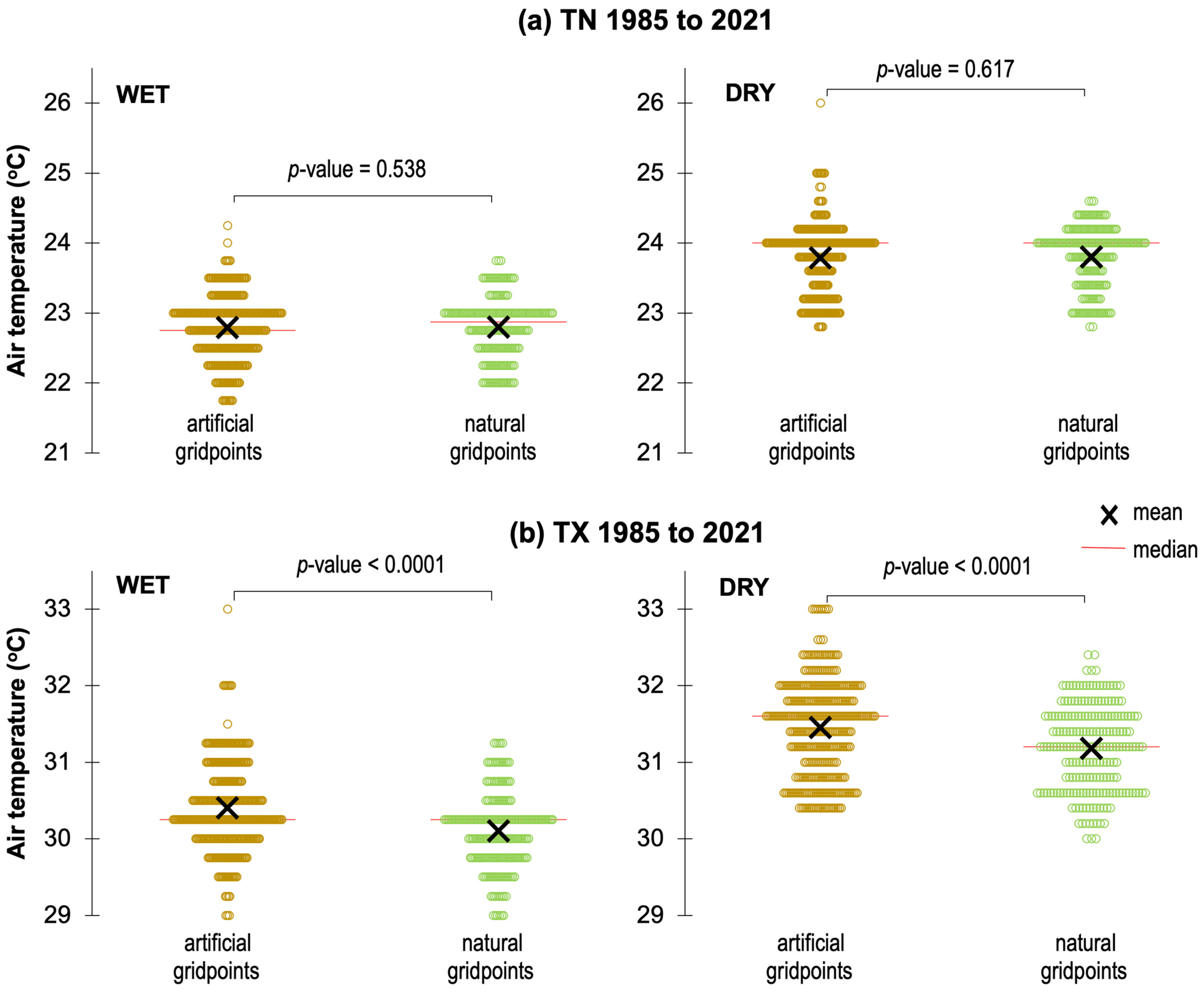
3.2. Spatial Patterns and Changes in Seasonal Air Temperature

Firstly, we analyzed the TN and TX seasonal data for the Belém in situ station and the CRU (nearest grid point) in the period from 1985 to 2021. In Figure 5a, the scatterplot for the TX variable reveals a positive linear relationship with high correspondence between the data with R2 0.818 and a correlation of 0.91 in the DRY season and R2 0.820 and a correlation of 0.90 in the WET season. For the TN variable, the high values of R2 0.669 and correlation of 0.82 in the DRY season and R2 0.622 and correlation of 0.79 in the WET season are also verified. Figure 5b and Figure 6c show the time series from 1985 to 2021 of seasonal TX and TN variables, in which the trend of systematic increase in both variables and seasonal regimes is noticeable, and the CRU captures well the temporal variability of the seasonal regimes throughout the period analyzed. Therefore, we have demonstrated that the CRU data are consistent with in situ observations, and then we can coherently use this high spatial resolution gridded data to analyze the spatial patterns over the whole metropolitan area of Belém.
The CRU climatological patterns (1985 to 2021 historical mean) of TN and TX variables in the WET and DRY seasons over the continental portion of the municipality of Belém and neighboring areas are shown in Figure 6. In these results, the hemeroby map was placed in the background to emphasize that the air temperature is generally relatively higher in artificial areas and lower in natural areas. The climatological conditions of TN are similar in both seasonal periods, with relatively lower values (22.6 to 22.8 °C in WET; 23.6 to 23.8 °C in DRY) in the easternmost portion of the region (southeast of the municipal seat and western Mosqueiro island) and higher (22.8 to 23 °C in WET; 23.7 to 24 °C in DRY) in the westernmost part that covers the most densely urbanized area of Belém and in the coastal zone with medium intensity urbanization over the island of Mosqueiro (Figure 6a). On the other hand, the climatology of TX displays an interesting configuration in both seasonal regimes, with a circular-shaped area presenting a warmer center (reaching a maximum value of 30.6 °C in WET and 31.6 °C in DRY) over the continental urban area of Belém, and a gradual decrease in the northern and eastern edges, with values reaching around 30.1 °C in WET and 31.2 °C in DRY season (Figure 6b).
In the point data for the Belém station, we already show evidence of a systematic increase in air temperature (Figure 5) during the last decades. This warming trend is confirmed spatially in the entire region, as shown in Figure 7, which contains the positive changes in TN and TX given by the difference between the 2004/2021 and 1985/2002 samples. In the TN map (Figure 7a) for the WET season, values of 0.45 to 0.5 °C are seen in the portion with a predominance of artificial urbanization coverage in the center and south and 0.4 °C in the northern area with a more natural surface, while the DRY season presents values from 0.55 to 0.65 °C in the central-south sector (artificial cover) and values 0.5 and 0.55 °C in the northernmost sector (natural cover). In the TX map (Figure 7b), looking particularly at the island of Mosqueiro to the north, a greater positive trend (0.75 °C in WET and 0.95 °C in DRY station) is noticeable in the coastal strip with medium urbanization and a smaller trend in the interior area where there is the presence of natural forest. In the more urban southern continental area, the warming trend varies between 0.65 and 0.7 °C in WET and reaches a maximum value of 1 °C in the DRY season.
The evidence of a warmer climate associated with urbanization in the metropolis of Belém is confirmed quantitatively through the descriptive statistics presented in Table A2 (see Appendix A) and the boxplots in Figure 8. Except for variance and standard deviation (with lower values), the statistical parameters of TN and TX in the period 2004/2021 are all higher when compared to the values in the period 1985/2002 (Table A1), as shown in the boxplots in orange with the position above the boxplots in blue (Figure 8a,b). The analysis considering the set of gridpoints with natural and artificial hemeroby class (see the location of gridpoints indicated in the map on the right in Figure 8) allowed us to verify that the changes, i.e., the systematic increase in air temperature is relatively higher in areas with urbanization when compared to areas with vegetation. The TN increment was 0.39 and 0.45 in the WET and 0.53 and 0.60 in the DRY season for the natural and artificial areas, respectively (Figure 8c). The most expressive values were observed for TX, with an increase of 0.58 and 0.62 in WET and 0.83 and 0.97 in the DRY season for natural and artificial areas, respectively (Figure 8d).
Finally, we report the results obtained in the statistical calculations of the difference between the historical time series (1985 to 2021) of the CRU gridpoint sets selected for the artificial and natural areas over continental Belém. Table 2 shows the values obtained in the T-test, and Figure 9 illustrates the scattergrams in which it is possible to visualize the distribution of sets of gridpoints for seasonal TN and TX. The TN variable did not pass the test (difference close to zero); however, TX showed a statistically significant positive difference with 0.27 °C in WET and 0.31 °C in the DRY season; thus we have proven that urbanized districts and areas are significantly warmer than other regions of Belém. In other words, the expansion of the urban area in Belém directly contributes to the increase in maximum temperature (afternoon period), especially in the July to November months.

4. Discussion

The hemeroby methodology in studies of anthropogenic changes in the landscape was initially used in Europe [8,10]. In South America, Gutiérrez [29] investigated long-term LULC changes by using hemeroby metrics in the Mucujún watershed of the Venezuelan Andes and documented not only forest recovery but also urban area growth, intensified land use and invasions by non-native species. Nino [30] used this technique to generate thematic cartography and spatial analysis to support land use planning in the Colombian Orinoquía at the foothills of the Andean Cordillera. Particularly for Brazil, there are examples of applications in different landscapes over South, Southeast and Northeast regions [11,12,13,14]. The applicability of this remote sensing technique to a metropolitan region within the Brazilian Amazon was conducted in the present work. Our findings concerning the degree of artificiality induced by anthropogenic pressures on the municipality of Belem (Figure 3), in addition to the mapping results being consistent with the MapBiomes product [16], are in line with the LULC classification study using the Sentinel family products [31]. The multi-temporal dynamic mapping in this municipality from 1985 to 2020 was investigated by [16], with indications of significant population growth of around 34% (1,120,777 in 1985 to 1,499,641 inhabitants in 2020), such that the vegetation suppression of almost 5% of the forest cover was converted primarily in urban areas (4.4% increase) and to a lesser extent in pasture/agricultural areas. These authors reported a systematic and disorderly urban sprawl occurred in the northern portion of the region, which results following our hemeroby mapping (Figure 3) that indicated a present higher urbanization process now occupying the whole central and northern portion of continental Belém, including Outeiro island and the coastal zone of Mosqueiro island in the extreme north of the region.
According to previous regional modeling studies, the direct effect of LULC changes resulting in the modification of the energy budget with a partition of the sensible heat flux relatively higher than the latent heat flux is the plausible explanation for the surface atmosphere to warm, thus yielding a warmer climate [32]. Such environmental impacts on the local climate were addressed for the Belém region through integrated analyses of heterogeneous landscape patterns (hemeroby mapping) and the corresponding spatial configuration and intensity of air temperature. Our observational findings showed that the regions where the conservation of primary forest vegetation prevailed (natural ahemerobic degree) coincide with a relatively smaller increase in air temperature when compared to the areas where the urbanization process predominates (artificial metahemerobic degree), according to quantitative results in Table 2 and Figure 8. Silva [33] found a significant positive correlation between surface temperature maps and the NDBI and NDBal indices (spectral indicators of land cover in built-up areas and primary and secondary bare land) generated by Landsat satellite images in the region metropolitan area of Belém.
The high spatial resolution gridded TN and TX air temperature data from the CRU database, which were properly validated with in situ measurements from the Belém station, presented seasonal patterns consistent with previous studies. A relevant result was the approximately circular configuration of the climatological TX in both seasonal regimes (Figure 6b), with a predominantly warmer center over the urbanized area and a gradual thermal decrease in the more peripheral areas, whose pattern resembles the classic urban heat island model [23,34]. Lola [35] carried out a field experiment with hourly air temperature measurements during October 1995 in twenty different districts in the city of Belém, producing geospatial maps in which the highest values were observed in the area with the highest vertical density of constructions. These authors found the most intense circular configuration of the heat island in the period between 01 and 03 PM local time, with values exceeding 32 °C in the central town. Silva [36] expanded these data collection campaigns and combined them with a historical series to calculate the heat index, with results indicating a broad area of thermal discomfort centered on the metropolis of Belém. On the other hand, [37] reported observational evidence of the heat island in the Manaus region over the central Amazon, indicating that the urban environment creates a local increase in air temperature and a decrease in relative humidity, mainly in the afternoon (between 3 and 5 PM local time). Similarly, the heat island phenomenon in the city of Manaus was detected from the analysis of meteorological stations and surface temperature patterns from the MODIS sensor of the Aqua environmental satellite, considering the September 2009/2012 mean, with indications of strong warming reaching 40 °C in the center urban [38].

5. Conclusions

The systematic and disorderly urbanization process is the most radical form of transformation of the natural landscape, resulting in an eminently anthropized environment. In this work, we reported a contribution to the studies of landscape dynamics induced by human pressure directly related to the urbanization process, whose approach is based on the concept of hemeroby applied to metropolitan areas in the Brazilian eastern Amazon. Our first conclusion is that this remote sensing technique was successful in representing LULC changes in the municipality of Belém, with robust observational evidence, and consistent with previous studies, that the artificial urban coverage (polyhemerobic and metahemerobic degrees that indicate an urban system with medium to high intensity) has increased by almost 17% during the last three and a half decades, while vegetation suppression of primary forest cover (ahemerobic degree) was around 11% (comparison between 1985 and 2021 patterns). Thus, of 100% of the present municipal geographic domain, the area with natural coverage of conserved forests is approximately 52% (restricted in an environmental protection area located in the southeast continental portion, over the small islands to the south and, in the interior of the largest island to the north sector), while the artificially urbanized coverage occupies an area of around 35%, with a clear indication of intense and disorderly expansion towards the central and northern continental portion and along the coastal zone of the Mosqueiro island.
Based on statistical analyses (comparisons between 18-year samples, 1985/2002 and 2004/2021) integrating the climatological patterns and seasonal trends of CRU high spatial resolution meteorological data with natural and artificial hemeroby maps over the study area, we have our second conclusion: the urban expansion had a direct impact on the current significantly warmer climate, with a notable indication of higher surface air temperatures in the most densely urbanized areas, compared to values in other areas of Belém. The increase in TN and TX was more expressive in the DRY season (July to November), when large-scale external meteorological systems are absent, providing the preponderance of local and regional physiographic effects, i.e., the effect of the city is more relevant at this time of year. Particularly for the TX variable, we evidenced a climatological pattern similar to the classic heat island model with concentric isotherms that reach a maximum center over the more urbanized continental region of Belém and thermal decrease at the edges of the region. As this pattern was not verified in the TN variable, therefore the phenomenon of the urban heat island in Belém is manifested in the afternoon (the time at which the TX is measured at the station), with higher intensity during the DRY season when the central maximum reaches 31.6 °C and the periphery 31.1 °C, with a spatial variation of around 0.5 °C that is relevant for Amazonian humid tropical regions. This interesting finding requires further studies, particularly using the regional modeling tool, as there is a lack of meteorological data measured in situ.
Therefore, the findings of this work are convincing that Belém already faces the impacts of urbanization on the local climate and, given the future climate change scenarios that project worsening of atmospheric warming in cities, it is crucial to develop government strategies aimed at taking action to mitigate and minimize the socioenvironmental risks and threats to the well-being and health of the urban population.

Author Contributions

Conceptualization, L.S.F. and E.B.d.S.; methodology, software, formal analysis, L.S.F., R.V.S.P. and E.B.d.S.; writing—original draft preparation, L.S.F., R.V.S.P. and E.B.d.S.; writing—review and editing, L.S.F. and E.B.d.S.; supervision, project administration, funding acquisition, E.B.d.S. All authors have read and agreed to the published version of the manuscript.

Funding

The APC was funded by the Pró-Reitoria de Pesquisa e Pós-Graduação/Universidade Federal do Pará (PROPESP/UFPA)—PAPQ (Programa de Apoio à Publicação Qualificada).

Data Availability Statement

Databases with respective sources and references were described in the Materials and Methods section.

Acknowledgments

L.S.F. thanks CAPES for the M.Sc. scholarship. E.B.d.S. thanks CNPQ (PQ2 process 313148/2020-1 and project process 442261/2020-9).

Conflicts of Interest

The authors declare no conflicts of interest.

Appendix A

Table A1. List of acronyms and abbreviations.
CRU-TSClimatic Research Unit gridded Time Series
DRYDry season from July to November
EPAMRBEnvironmental Protection Area of the Metropolitan Region of Belém
INMETInstituto Nacional de Meteorologia
LULCLand Use and Land Cover
MODISModerate-Resolution Imaging Spectroradiometer
NDBaINormalized Difference Bareness Index
NDBINormalized Difference Built-Up Index
OLIOperational Land Imager
QGISQuantum Geographic Information System
R2Coefficient of determination
RGBRed, green, and blue
TMThematic Mapper
TNMinimum temperature
TXMaximum temperature
USGSUnited States Geological Survey
USPCUUtinga State Park Conservation Unit
UTMUniversal Transverse de Mercator
WETWet or Rainy season from January to April
Figure A1. LULC maps based on MapBiomas over the continental portion of Belém for the years (a) 1985 and (b) 2021. The classes are indicated in the legend.
Urbansci 08 00015 g0a1
Table A2. Descriptive statistics of TN and TX for WET and DRY seasons considering the set of CRU gridpoints over natural and artificial areas (points indicated in the map on the right in Figure 8) in the periods 1985/2002 and 2004/2021. The unit is °C.
MinimumMaximum1st QuartileMedian3rd QuartileMeanVarianceStandard Deviation
TNWETnatural1985 to 200222.023.822.322.823.022.60.190.44
artificial2004 to 202122.323.822.823.023.323.00.100.32
natural1985 to 200221.824.022.322.523.022.60.200.45
artificial2004 to 202122.324.322.823.023.323.00.120.34
DRYnatural1985 to 200222.824.423.223.623.823.50.170.42
artificial2004 to 202123.024.624.024.024.224.10.070.26
natural1985 to 200222.824.623.023.423.823.50.180.42
artificial2004 to 202123.226.024.024.024.224.10.120.35
TXWETnatural1985 to 200229.031.029.529.830.329.80.170.41
artificial2004 to 202129.831.330.330.330.830.40.150.39
natural1985 to 200229.031.329.830.030.330.10.170.41
artificial2004 to 202129.833.030.330.531.030.70.270.52
DRYnatural1985 to 200230.031.630.630.631.030.80.150.38
artificial2004 to 202131.032.431.431.631.831.60.110.33
natural1985 to 200230.432.030.630.831.230.90.160.41
artificial2004 to 202131.233.031.631.832.231.90.160.40

References

  1. Kennedy, C.; Pincetl, S.; Bunje, P. The Study of Urban Metabolism and Its Applications to Urban Planning and Design. Environ. Pollut. 2011, 159, 1965–1973. [Google Scholar] [CrossRef]
  2. Glaeser, E.L. A World of Cities: The Causes and Consequences of Urbanization in Poorer Countries. J. Eur. Econ. Assoc. 2014, 12, 1154–1199. [Google Scholar] [CrossRef]
  3. Haase, D.; Larondelle, N.; Andersson, E.; Artmann, M.; Borgström, S.; Breuste, J.; Gomez-Baggethun, E.; Gren, Å.; Hamstead, Z.; Hansen, R.; et al. A Quantitative Review of Urban Ecosystem Service Assessments: Concepts, Models, and Implementation. Ambio 2014, 43, 413–433. [Google Scholar] [CrossRef] [PubMed]
  4. Souza, C.M., Jr.; Shimbo, J.Z.; Rosa, M.R.; Parente, L.L.; Alencar, A.A.; Rudorff, B.F.T.; Hasenack, H.; Matsumoto, M.; Ferreira, L.G.; Souza-Filho, P.W.M.; et al. Reconstructing Three Decades of Land Use and Land Cover Changes in Brazilian Biomes with Landsat Archive and Earth Engine. Remote Sens. 2020, 12, 2735. [Google Scholar] [CrossRef]
  5. Fehrenbach, H.; Grahl, B.; Giegrich, J.; Busch, M. Hemeroby as an Impact Category Indicator for the Integration of Land Use into Life Cycle (Impact) Assessment. Int. J. Life Cycle Assess. 2015, 20, 1511–1527. [Google Scholar] [CrossRef]
  6. Jalas, J. Hemerobe und Hemerochore Pflanzenarten: Ein Terminologischer Reformversuch. Acta Soc. Fauna Flora Fenn. 1955, 72, 1–15. [Google Scholar]
  7. Steinhardt, U.; Herzog, F.; Lausch, A.; Müller, E.; Lehmann, S. Hemeroby Index for Landscape Monitoring and Evaluation. In Environmental Indices—System Analysis Approach; Pykh, Y.A., Hyatt, D.E., Lenz, R.J., Eds.; EOLSS Publ.: Oxford, UK, 1999; pp. 237–254. [Google Scholar]
  8. Walz, U.; Stein, C. Indicators of Hemeroby for the Monitoring of Landscapes in Germany. J. Nat. Conserv. 2014, 22, 279–289. [Google Scholar] [CrossRef]
  9. Tian, Y.; Liu, B.; Hu, Y.; Xu, Q.; Qu, M.; Xu, D. Spatio-Temporal Land-Use Changes and the Response in Landscape Pattern to Hemeroby in a Resource-Based City. ISPRS Int. J. Geo-Inf. 2020, 9, 20. [Google Scholar] [CrossRef]
  10. Hill, M.O.; Roy, D.B.; Thompson, K. Hemeroby, urbanity and ruderality: Bioindicators of disturbance and human impact. J. Appl. Ecol. 2002, 39, 708–720. [Google Scholar] [CrossRef]
  11. Belem, G.; Nucci, J.C. Hemerobia das paisagens: Conceito, classificação e aplicação no bairro Pici-Fortaleza/CE. Raega-O Espaço Geogr. Anál. 2011, 21, 204–233. [Google Scholar] [CrossRef]
  12. Liberti, E.; Leite, H.R.; Silva, M.C.D.; Nucci, J.C. As paisagens do município de Pinhais (Paraná/Brasil): Uma abordagem segundo o conceito de hemerobia. Caminhos Geogr. 2019, 20, 189–201. [Google Scholar] [CrossRef]
  13. Silva, F.L.; Aguiar López, F.M.; Machado, R.; Oliveira-Andreoli, E.Z.; Fushita, Â.T.; Cunha-Santino, M.B.; Bianchini Júnior, I. An Approach to Verify Naturalness Loss and Its Relation with Ecosystems Services in Brazilian Cerrado: Implications to Management. J. Geosci. Environ. Prot. 2022, 10, 55–74. [Google Scholar] [CrossRef]
  14. Gusmão, L.H.A.; Lobo, M.A.A.; Tourinho, H.L.Z. Mudança do Uso e da Cobertura da Terra e Hemerobia das Paisagens: O caso da Região Geográfica Imediata de Belém—Pará (1985–2018). Geografia 2021, 30, 169–189. [Google Scholar] [CrossRef]
  15. Mapbiomas. MapBiomas General ‘Handbook’—Algorithm Theoretical Basis Document (ATBD). Collection 8, Version 1. August 2023. Available online: https://brasil.mapbiomas.org/wp-content/uploads/sites/4/2023/09/ATBD-Collection-8-v1.1.docx.pdf (accessed on 10 July 2023).
  16. Gutierrez, C.B.B.; de Souza, E.B.; Gutierrez, D.M.G. Global/Regional Impacts on Present and Near-Future Climate Regimes in the Metropolitan Region of Belém, Eastern Amazon. Atmosphere 2022, 13, 1077. [Google Scholar] [CrossRef]
  17. IBGE. Instituto Brasileiro de Geografia E Estatística. Panorama das Cidades Brasileira; IBGE: Rio de Janeiro, Brazil, 2022. Available online: https://cidades.ibge.gov.br (accessed on 10 July 2023).
  18. De Souza, E.B.; Ferreira, D.B.S.; Guimarães, J.T.F.; Franco, V.S.; Azevedo, F.T.M.D.; Moraes, B.C.D.; De Souza, P.J.O.P. Padrões Climatológicos e Tendências da Precipitação nos Regimes Chuvoso e Seco da Amazônia Oriental. Rev. Bras. Climatol. 2017, 21, 81–93. [Google Scholar] [CrossRef]
  19. Arnfield, A.J. Two decades of urban climate research: A review of turbulence, exchanges of energy and water, and the urban heat island. Int. J. Climatol. 2003, 23, 1–26. [Google Scholar] [CrossRef]
  20. Voogt, J.A.; Oke, T.R. Thermal remote sensing of urban climates. Remote Sens. Environ. 2003, 86, 370–384. [Google Scholar] [CrossRef]
  21. Oke, T.R. The energetic basis of the urban heat island. Q. J. R. Meteorol. Soc. 1982, 108, 1–24. [Google Scholar] [CrossRef]
  22. Romero, M.A.B.; Baptista, G.M.M.; Lima, E.A.; Werneck, D.R.; Vianna, E.O.; Sales, G.L. Mudanças Climáticas e Ilhas de Calor Urbanas, 1st ed.; Universidade de Brasília, Faculdade de Arquitetura e Urbanismo: Brasilia, Brazil, 2019; Available online: https://livros.unb.br/index.php/portal/catalog/book/180 (accessed on 7 March 2023).
  23. Lombardo, M.A. A Ilha de Calor de São Paulo. Rev. Ambiente 1988, 2, 14–18. Available online: https://revista.cetesb.sp.gov.br/revista/article/view/49 (accessed on 7 March 2023).
  24. Monteiro, F.F.; Gonçalves, W.A.; Andrade, L.M.B.; Villavicencio, L.M.M.; Silva, C.M.S. Assessment of Urban Heat Islands in Brazil based on MODIS remote sensing data. Urban Clim. 2021, 35, 100726. [Google Scholar] [CrossRef]
  25. Harris, I.; Osborn, T.J.; Jones, P.D.; Lister, D.H. Version 4 of the CRU TS Monthly High-Resolution Gridded Multivariate Climate Dataset. Sci. Data 2020, 7, 109. [Google Scholar] [CrossRef] [PubMed]
  26. Fick, S.E.; Hijmans, R.J. WorldClim 2: New 1km Spatial Resolution Climate Surfaces for Global Land Areas. Int. J. Climatol. 2017, 37, 4302–4315. [Google Scholar] [CrossRef]
  27. QGIS Development Team. QGIS Geographic Information System. Open Source Geospatial Foundation Project. 2023. Available online: https://qgis.org/en/site/ (accessed on 6 March 2023).
  28. Dutra, V.A.B.; Tavares, P.A.; de Lima, A.M.M. Anthropogenic Environmental Pressures in Urban Conservation Units: A Case Study in Belém, Brazilian Eastern Amazon. Int. J. Hydrol. 2022, 6, 131–139. [Google Scholar] [CrossRef]
  29. Gutiérrez, B.N.; Gärtner, S.; López, H.J.Y.; Pacheco, C.E.; Reif, A. The Recovery of the Lower Montane Cloud Forest in the Mucujún Watershed, Mérida, Venezuela. Reg. Environ. Chang. 2013, 13, 1069–1085. [Google Scholar] [CrossRef]
  30. Niño, L.; Jaramillo, A.; Villamizar, V.; Rangel, O. Geomorphology, Land-Use, and Hemeroby of Foothills in Colombian Orinoquia: Classification and Correlation at a Regional Scale. Pap. Appl. Geogr. 2023, 9, 295–314. [Google Scholar] [CrossRef]
  31. Tavares, P.A.; Beltrão, N.E.S.; Guimarães, U.S.; Teodoro, A.C. Integration of Sentinel-1 and Sentinel-2 for Classification and LULC Mapping in the Urban Area of Belém, Eastern Brazilian Amazon. Sensors 2019, 19, 1140. [Google Scholar] [CrossRef]
  32. Llopart, M.; Reboita, M.S.; Coppola, E.; Giorgi, F.; Da Rocha, R.P.; De Souza, D.O. Land Use Change over the Amazon Forest and Its Impact on the Local Climate. Water 2018, 10, 149. [Google Scholar] [CrossRef]
  33. Silva, M.T.; Margalho, E.S.; Serrão, E.A.O.; Souza, A.C.; Soares, C.S.; Santos, C.A.C.; Silva, B.B. Application of Spatial Modeling of Biophysical Variables in an Urbanized Area in the Amazon: The Case of the Metropolitan Area of Belém-Pará. Rev. Bras. Meteorol. 2021, 36, 271–283. [Google Scholar] [CrossRef]
  34. Freitas, E.D.; Dias, P.L.S. Alguns Efeitos de Áreas Urbanas na Geração de uma Ilha de Calor. Rev. Bras. Meteorol. 2005, 20, 355–366. [Google Scholar]
  35. Lola, A.C.; Silva Junior, J.A.; Cunha, A.C.; Galbraith, D.G.; Feitosa, J.R. Distribuição Geoespacial e Horária da Temperatura do Ar na Cidade de Belém-PA: Estudo de Caso em 1995. Braz. Geogr. J. 2013, 4, 3. Available online: https://seer.ufu.br/index.php/braziliangeojournal/article/view/22691 (accessed on 6 March 2023).
  36. Silva Júnior, J.A.; Costa, A.C.L.; Pezzuti, J.C.B.; Costa, R.F.; Galbraith, D. Análise da Distribuição Espacial do Conforto Térmico na Cidade de Belém, PA no Período Menos Chuvoso. Rev. Bras. Geogr. Fís. 2012, 2, 218–232. [Google Scholar]
  37. Souza, D.O.; Alvalá, R.C.S. Observational Evidence of the Urban Heat of Manaus City, Brazil. Meteorol. Appl. 2014, 21, 186–193. [Google Scholar] [CrossRef]
  38. Corrêa, P.B.; Candido, L.A.; Souza, R.A.F.; Andreoli, R.V.; Kayano, M.T. Estudo do Fenômeno da Ilha de Calor na Cidade de Manaus/AM: Um Estudo a Partir de Dados de Sensoriamento Remoto, Modelagem e Estações Meteorológicas. Rev. Bras. Meteorol. 2016, 31, 167–176. [Google Scholar] [CrossRef]
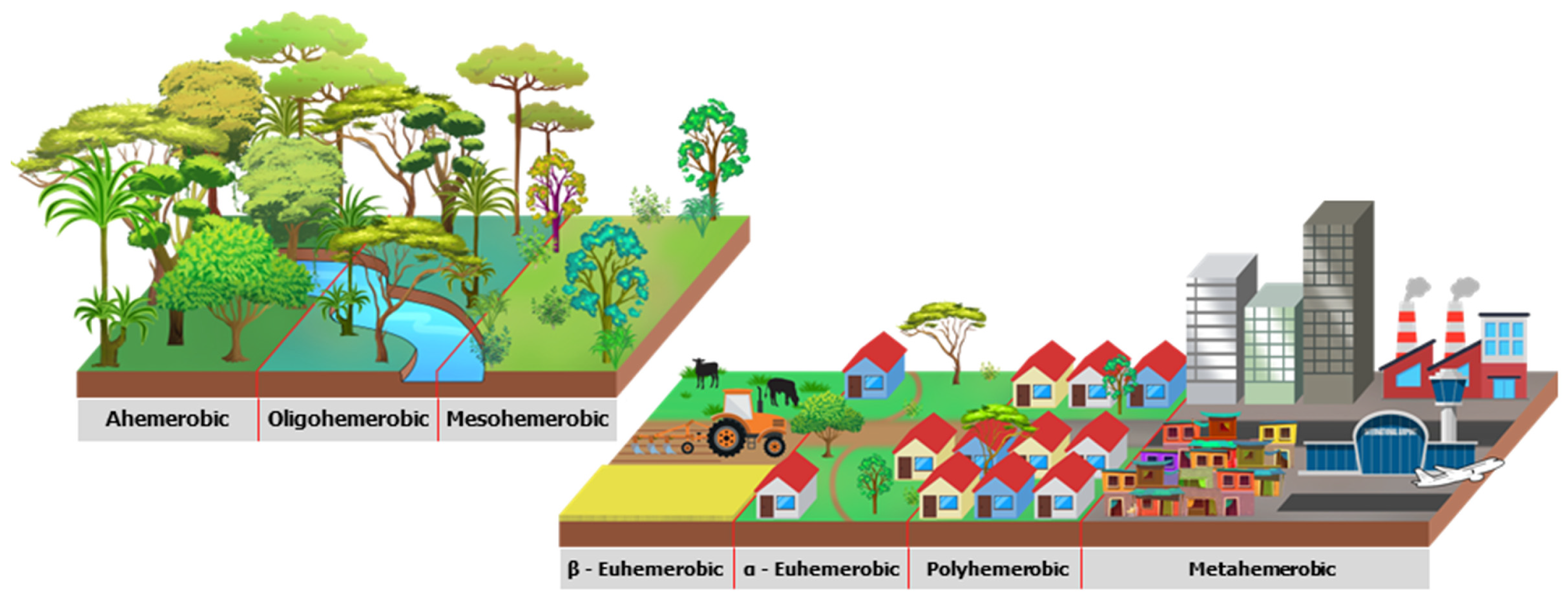
Figure 1. (a) Study area in the municipality of Belém, (b) the state of Pará, and (c) in the Brazilian eastern Amazon. The red hatched area indicates the continental portion and islands where the analysis will be emphasized.
Urbansci 08 00015 g001
Figure 2. Diagram with a realistic visualization of the main features of the landscape associated with the seven hemeroby degrees for a metropolitan area in eastern Amazon.
Urbansci 08 00015 g002
Figure 3. Hemeroby degree maps over the continental portion of Belém for the years (a) 1985 and (b) 2021. The classes are indicated in the legend.
Urbansci 08 00015 g003
Figure 4. (a) Total area (km2) and percentages (%) in each hemeroby class for 1985 and 2022; (b) changes (%) from 1985 to 2022.
Urbansci 08 00015 g004
Figure 5. (a) Scatter plot of 1985 to 2021 TX and TN for STATION and CRU data during WET and DRY seasons, including respective R2 and correlation values; Time-series from 1985 to 2021 of (b) TX and (c) TN for STATION and CRU during WET and DRY seasons. The unit is °C.
Urbansci 08 00015 g005
Figure 6. CRU climatology (1985 to 2021 historical mean) of (a) TN and (b) TX in WET and DRY seasons over the continental portion of Belém and neighboring areas. The air temperature isoline interval is 0.1 °C. The background is the hemeroby map in the year 2021.
Urbansci 08 00015 g006
Figure 7. Change (difference between 2004/2021 and 1985/2002) of (a) CRU TN and (b) TX in WET and DRY seasons over the continental portion of Belém and neighboring municipalities. The air temperature isoline interval is 0.05 °C. The background is the hemeroby map in the year 2021.
Urbansci 08 00015 g007
Figure 8. Boxplots for (a) TN and (b) TX for WET and DRY seasons considering the set of CRU gridpoints over natural and artificial areas (points indicated in the hemerobic map on the right) in the periods 1985/2002 and 2004/2021; Changes for (c) TN and (d) TX given by the difference between 2004/2021 and 1985/2002 means over natural and artificial areas. The unit is °C.
Urbansci 08 00015 g008
Figure 9. Scattergrams of the sets of CRU gridpoints for artificial (urbanization) and natural (forest) areas over Belém for (a) TN and (b) TX in WET and DRY seasons. The time series are 1985 to 2021, and the unit is °C.
Urbansci 08 00015 g009
Table 1. Hemeroby degree and corresponding intensity of human interference, including environmental descriptions of the European landscape that was adapted to the study area.
Hemeroby DegreeIntensity of Human InterferenceEuropean Landscape from [8]Adaptations to the Amazon Metropolitan Landscape
AhemerobicNatural: no or minimal human impactRocks, glaciers, and perpetual snowPrimary forest
OligohemerobicNear natural: weak anthropic alteration and recovering vegetationForests, beaches, dunes, sands, lagoons, wetlands, sea and oceanSecondary forest and wetlands
MesohemerobicSemi-natural: moderate human impactNatural pastures, forest shrubs, transitional forest, burned areas, and sparse vegetationEcological pioneer succession and small clearings
β-EuhemerobicAgricultural: disturbed area by human action on a regular basisUrban green areas, pastures, agriculture, watercoursesPastures, plantations, farms, urban green areas, and riverside dwellings
α-EuhemerobicCultural: high impacts on the natural systemSports and leisure facilities, non-irrigated land, vineyards, fruit trees, and cultivation patternsLow-density urban areas and public squares
PolyhemerobicArtificial: little natural presence and irreversible changesDiscontinuous urban networks, construction sites, public places, and waste disposal and mining industriesMedium-density urban, mineral extraction, and garbage disposal sites
MetahemerobicTotally artificial: completely modified environmentContinuous urban network, railways, ports, and airportsDense urban system, verticalization, industries, highways
Table 2. The Student’s T-test for the difference between the sets of TN and TX CRU gridpoints for artificial and natural areas over Belém municipality in the WET and DRY seasons.
TNTX
WETDRYWETDRY
Difference (°C)0.0040.0120.27 10.31 1
Degrees of freedom415491498496
p-value0.5380.617<0.0001<0.0001
1 Statistically significant.
Disclaimer/Publisher’s Note: The statements, opinions and data contained in all publications are solely those of the individual author(s) and contributor(s) and not of MDPI and/or the editor(s). MDPI and/or the editor(s) disclaim responsibility for any injury to people or property resulting from any ideas, methods, instructions or products referred to in the content.

