1. Introduction
During the last few decades, China has experienced rapid urbanisation. This is characterised by large-scale urban expansion and considerable urban rural migration [
1]. As a result, China’s informal settlements known as urban villages—villages inside urbanised areas—emerged and have become a common phenomenon, especially in the major cities such as Guangzhou, Shenzhen, Shanghai, and Beijing [
2,
3,
4]. Urban villages are considered supplementary to the formal planning system [
5] and everyday neighbourhoods that provide urban life for migrants without legal urban status [
6]. Scholars reveal this contribution from socio-economic perspectives, arguing that urban villages help integrate the migrants into urban society [
3,
4] by providing affordable housing and amenities [
2,
7,
8,
9]. However, the living conditions of urban villages do not often meet the standards of official planning [
10,
11]. Moreover, the production and exchange of goods that occur in urban villages tend to transgress regulations and laws [
12].
Research has revealed that the morphology of urban villages affects urban life at a micro scale. For example, literature has shown that the diversity of land use [
5] and the dynamic of activities in the public realm [
6,
13,
14] are affected by the morphology of urban villages. However, more research is needed to examine the relationship between the morphology and urban life in these villages. In order to address this gap, this paper investigates how spatial characteristics of urban villages from the perspective of urban morphology contribute to our understanding of the complex informality of these settlements. To this end, we use a framework that is in line with previous morphological studies in the context of formal and informal settlements [
11,
12,
13,
14]. According to this framework, the four key spatial elements that need to be taken into account in any morphological studies include density, accessibility, functional mix, and urban interface.
Using the case study of Dayuan Village in Guangzhou, this paper aims to understand the key features of these four morphological elements and the underlying relationship between them. The results of this study demonstrate that this framework can be used to examine the urban morphology of informal settlement of urban villages in China. The framework can enable built environment professionals, such as architects, urban planners, and designers, to have a better understanding of how the incremental, self-organised space operates within urban villages. In this paper, we first discuss the typology, image, and informality of urban villages in China, as well as the literature on urban morphology in informal settlements. The paper goes on to present the utilised methodology, consisting of a case study approach and data collection and analysis methods. We then present the results of our analyses in terms of the four morphological elements of density, accessibility, functional mix, and urban interface, as well as their relations, in Dayuan Village in Guangzhou.
2. Literature Review
2.1. Urban Village: Typology, Image, Informality
‘Urban village’ is a translation from the Chinese term ‘chengzhongcun’, which literally means ‘the village embraced by the city’. After gaining attention among researchers in the 2000s [
15], two terms (English translations) have been used in academic papers for referring to ‘chengzhongcun’: urban village [
5,
16,
17,
18] and village-in-the-city [
19,
20]. The former translation is more popular among scholars [
15], while the latter refers to one particular type of urban village, those that are located in built-up urban areas and tend to have a higher degree of urbanisation. Considering the location of urban villages and whether they have farmland, Li [
21] proposed a classification of urban villages as such: (a) centrally located villages with no farmland left; (b) suburban villages that have a small amount of farmland; and (c) peri-urban villages which still consist of large areas of farmland. Based on the location of urban villages, Wang, Wang and Wu [
16] proposed a similar classification, dividing urban villages into three categories: (a) Chengzhongcun; villages located inside a city; (b) Chengbiancun; villages located at the edge of built-up areas; and (c) Chengwaicun; villages in suburban areas or industrial towns.
The image of urban villages among scholars has experienced a change from negative and subjective to positive and objective [
22]. In the 1990s and early 2000s, urban villages were considered as the dark side of urban development, and used to be referred to as ‘urban cancer’ in reference to their rapid and unregulated physical expansion. The ambiguous and ineffective regulations of rural land, which are rooted in the dual rural-urban system in China, have led to complex land rights, disordered construction, and a lack of infrastructure in urban villages. Considering their physical environment, which used to be characterised as ”dirty”, ”chaotic”, and ”deteriorated”, urban villages were perceived as a fertile ground for crime and fake products [
23]. This image has been changing in recent years. Jingxiang and Wei [
24] argued that the development of urban villages plays an irreplaceable role in alleviating the imbalance of China’s social structure and deprivation. In Futian district for example, 15 urban villages, occupying 390 hectares of land, house 572,100 migrants and 19,300 indigenous villagers (1515 persons per hectare) [
25]. The existence of such highly dense areas reveals not only the high demand for affordable housing, especially for migrants, but also the villagers’ pursuit for the maximisation of rental income [
26]. With the success in assimilating migrant workers and indigenous villagers into urban life [
5], urban villages can be considered as the third type of settlement following the urban and rural settlements in China. Urban villages also help to fill the gap of the dichotomy rural-urban system and diversified the social, economic, and spatial composition in China [
16].
Urban villages have often been characterised as informal settlements. Compared with slums and squatter settlements, the informality of urban villages is somewhat more complicated. According to the dual rural-urban land system, the land of urban villages is formally owned by villagers either individually or collectively, but the land use, construction, and trading operate informally [
23]. Village committees are the lowest level, yet an official part of the Chinese government structure. However, local governments have no jurisdiction in urban villages [
27]. Indigenous family clans still play an important role in the governance of villages [
28]. This complex nature of informality in urban villages enables villagers to construct their land and accommodate large numbers of migrants. This is because such informality provides space for villagers and migrants to transgress the state’s regulation in terms of formal urban planning, tenure, and construction [
29].
2.2. Morphological Thinking in Informal Settlements
Urban morphology is a critical issue to deal with the environment we inhabit. Helm and Robinson [
30] simply defined urban morphology as the pattern of land use within a town. Urban morphology is the study of human settlements in terms of their structure and the process of both formation and transformation [
31]. Density, access, functional mix, and urban interface are considered as the four key elements of urban analysis in general and urban morphology in particular [
32,
33,
34,
35]. Understanding their relation is a critical condition for exploring the morphology of an informal settlement. This section reviews the definition and measurement of these morphological elements to inform the research methods of the present study.
2.2.1. Density
The density of buildings is of central importance to urban morphology studies. Density of buildings is associated with different variables including building height, floor area ratio (FAR), and land coverage ratio. The number of floors of buildings is often used as a proxy for estimating building heights. FAR is the ratio of total floor areas to site areas, while land coverage is the ratio of footprints to site areas. FARs are often explicitly defined in urban planning and design guidelines [
36]. Ahmadpoor and Shahab [
37] explained urban density as one of the urban elements that form people’s spatial knowledge.
Building density is measured either as gross density or net density [
32,
38]. Berghauser Pont and Haupt [
39] proposed four levels in urban areas to illustrate the application of net and gross density: lot, island, fabric, and district levels. The lot level is the basic unit for market transactions [
32]. Hence, it should be measured in net density. The island level is the combination of multiple adjacent lots and the public space around them. It can be measured with either net density or gross density [
38]; net density is applied when only measuring the cluster of plots, while gross density is used when at least half of the adjacent streets are included. The fabric level is the combination of several adjacent islands. Since public space such as streets are included, this level uses a gross density. Finally, the district level is a broader urban area including various functions such as education, transport, parks, commercial, and residential. Planners often use gross density for the district level [
32]. Given some important aspects of urban planning and design such as walkability and viability of public transport are not considered using net density [
40], gross density is considered more appropriate when analysing urban morphology at large scales [
40].
2.2.2. Accessibility
Accessibility concerns movement, connectivity, and permeability [
34,
41,
42]. Movement flows are physically structured by street networks [
43] and include walking, cycling, public transports and vehicles. Zacharias, et al. [
18] pointed out that movements consist of the flows of people, goods, and vehicles. Connectivity can be considered as the extent to which two locations are easily connected. Southworth and Ben-Joseph [
44] measured connectivity with the number of access points in a given area. This approach is a measure of connectivity between a study area and its environs rather than the inter-connectivity within an urban area [
32]. Permeability is the result of small blocks which is argued by Jacobs [
45] as one of the conditions for urban diversity. Marshall [
46] described permeability as the extent to which an urban area is permeated by publicly accessible space. Permeability can be considered as the foundation for connectivity and ease of movement. Thus, measuring permeability is important in assessing accessibility. Berghauser Pont and Haupt [
39] used network density to measure permeability. Network density is the ratio of the total length of streets to the area of an urban area. Knight and Marshall [
47] used intersection density to analyse street network connectivity, referring to the number of intersections in a given urban area.
2.2.3. Functional Mix
Functional mix is an essential condition for the intensity of urban life and social and economic vitality [
45]. There is no consensus on the definition of functional mix. Taking the priority of activities into account, Jacobs [
45] divided land uses into primary and secondary uses. The primary uses provide the possibility for the presence of secondary uses. Working or living are considered as primary uses, and secondary uses, such as shops in apartment blocks or cafes in business districts, take place to service them [
48]. The functional mix can be considered as the mix of primary and secondary uses. Hoek [
49] considered mixed-use as a combination of three urban uses: housing, working, and amenities. Dovey et al. [
32] proposed a classification according to the purpose in which people go to a place. People live, work, or visit some kinds of facilities or amenities. Hence, the urban functions can be categorised into three primary groups: live, work, and visit. They argue that this framework includes overlapping classifications such as recreation, retail, entertainment, and community. There are different approaches to measure functional mix: entropy [
50], destinations [
51], mixed-use index [
48,
49], and the live/work/visit triangle [
32].
- (a)
Entropy: entropy is a borrowed concept from physics which measures the degree to which different functions occur equally within a certain territory. The entropy-based measurements were developed by Cervero [
52] and Frank et al. [
50,
53]. In their measurement of the functional mix, a score from 0 to 1 is calculated to describe the degree to which floor areas devoted to primary uses are equal within the 1-kilometer territory. The advantage of this measurement is that it not only reveals the proportion of different functions within a particular neighbourhood but also compares different neighbourhoods at the same scale [
32].
- (b)
Destination: in the destination-based measurements, functions are treated differently since they have different levels of attraction [
32]. For example, retail floorspaces attract more visitors than offices or apartments. Giles-Corti et al. [
54] and Rundle et al. [
55] used the degree of attractiveness of recreation and public transport. However, quantifying different levels of attractiveness is a complex task, since the attractiveness of the floor areas of different functions varies greatly. For example, within the same floor area, the shopping mall will attract much more visitors than apartment blocks. The key contribution of the destination-based approach is in recognising that different functions have various levels of attractiveness [
32].
- (c)
Mixed-use index (MXI): Hoek developed MXI, which measures the ratio of different functions by calculating the floor areas. Based on this index, urban functions are categorised into housing, working, and amenities. The three primary uses are placed into a triangular model, which is a framework to measure the extent of mix within the three categories. The framework provides a foundation for multi-scale analysis, ranging from individual buildings to neighbourhoods and districts in a city.
- (d)
Live/work/visit triangle: drawing on the MXI, Dovey et al. [
32] developed the live/work/visit triangle to analyse functional mix. Based on the purpose of people’s presence at a given place and given time, urban functions are divided into live, work, and visit. According to Dovey et al. [
32], ‘visit’ is a better label compared to ‘amenities’ since the latter is a generic term and could overlap with housing and working. In the measurement of MXI, functional mix is calculated by the floor areas, and all the functions are treated equally. Since the category of live/work/visit is based on people’s behaviour, the live/work/visit triangle takes attractiveness into consideration in assessing the difference between the three primary uses. As places for work and visit are more attractive than residential districts, Dovey et al. [
32] set a 1:2:5 ratio of live/work/visit as multiplier to ensure the evidence of calculation.
2.2.4. Urban Interface
Urban interface is the threshold between private and public territories [
34]. Dovey and Wood [
56] defined urban interface as a transitional space, where private spaces plug into public realms. Carmona [
57] considered urban interface as the area between public and private spaces that is physically demarked, but publicly accessible, such as street cafes and private pavement space. The importance of urban interface can be traced back to Jacobs’s argument [
45] about the uses of street sidewalks in terms of safety and contact. The degree of liveliness of urban area is related to the ways how the edges of buildings in an area work [
58]. Bobić [
59] pointed out that the quality of the urban interface deeply affects urbanity and the character of spaces that people perceive.
Gehl [
60] classified urban interfaces into two categories of soft and hard edges. Hard edges are deficient in details and indoor/outdoor connections dramatically limit the activities in public spaces. Soft edges, which provide space for sitting or standing, facilitate social activities. Dovey and Wood [
56] proposed a typology of urban interfaces, which considers four variables in terms of the physical characteristics of the edge of buildings: accessible/inaccessible, direct/setback, opaque/transparent, car/pedestrian. The typology consists of five types: impermeable/blank, direct opaque, direct transparent, pedestrian setback and car setback.
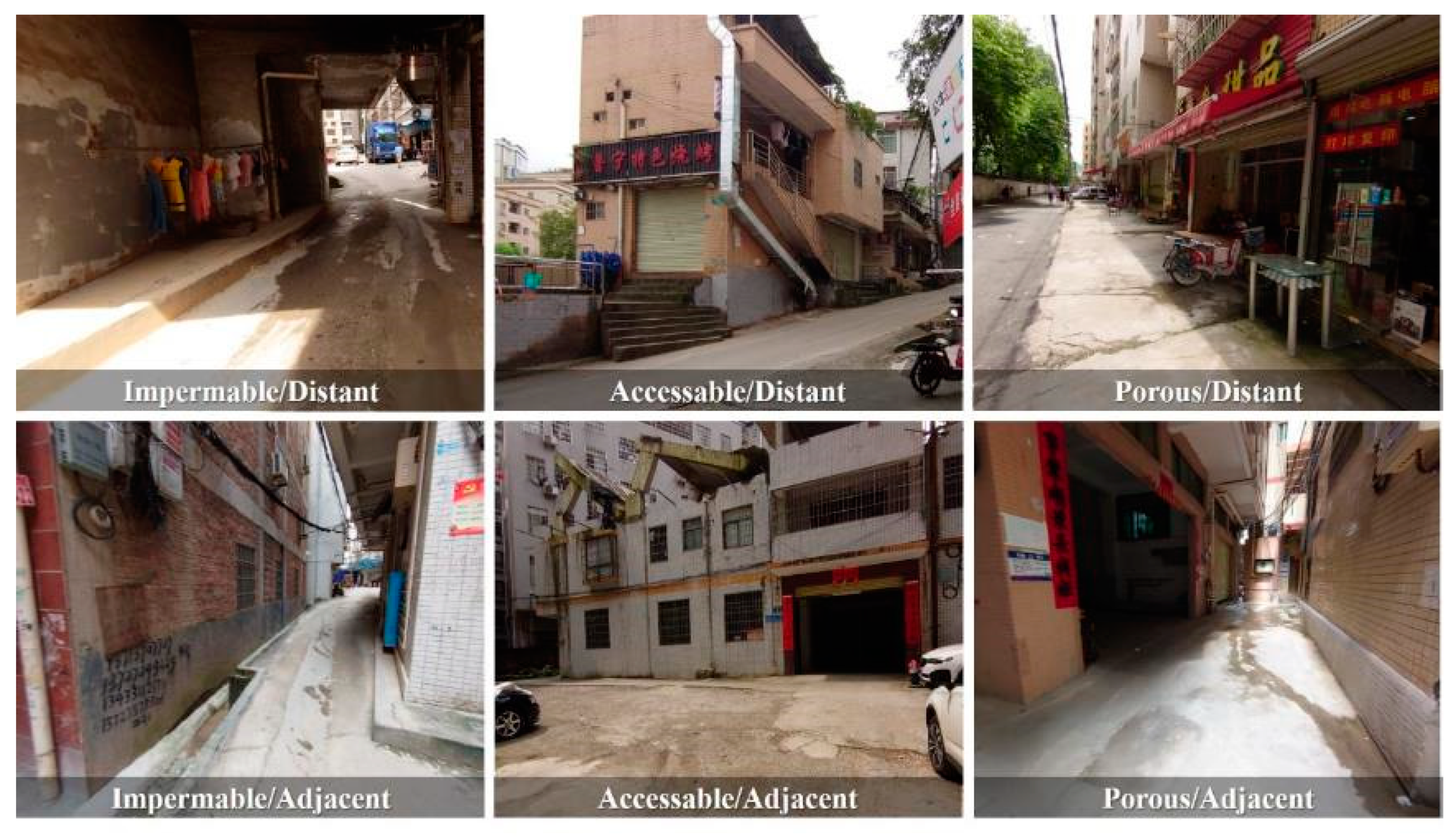
Considering connectivity and proximity, Kamalipour [
35] developed a typology of urban interfaces in informal settlements. Connectivity describes the extent to which the private space is connected to public realm. It is divided into three levels: impermeable, accessible, and porous. Although the extent of connectivity is a continuum, for the purpose of mapping, 50% of total length of interface is set as threshold [
35]. An interface is defined as porous if more than half of the length is open to public space. Accessible interfaces are those interfaces that up to 50% of their total length are open. Proximity refers to the degree to which private spaces are close to public spaces. It includes two levels: adjacent and distant and 50 cm is set as the threshold. If the edge of buildings is more than half a meter away from public space, it is considered a distant interface. Based on the two variables, six types of interface are proposed: impermeable/adjacent, accessible/adjacent, porous/adjacent, impermeable/distant, accessible/distant, and porous/distant. Although the thresholds of the two variables (i.e., 50% and 50 cm) seem somewhat arbitrary, the typology provides a clear framework for a systematic analysis.
3. Methodology
3.1. Case Study of Dayuan, Guangzhou
This research explores Dayuan Village, located in the Baiyun District of Guangzhou, China, as a case study. Case-study methodology is considered as a preferred approach when the focus of the research is on contemporary phenomena [
61]. The use of a single case study method, which is common in the field of urban planning and design [
62,
63], enables the researchers to develop a comprehensive and in-depth understanding of the case through studying it in detail. Exploring Dayuan Village is interesting for various reasons. It is located in Guangzhou, that is one of the major cities in China, and is the manufacturing, commercial, and logistics hub of the Pearl River Delta. The rapid process of urban expansion in Guangzhou has created 138 urban villages, and Dayuan Village is the largest one at 25 square kilometres, accommodating 9500 original inhabitants and a further 138,000 people who moved to the village [
64].
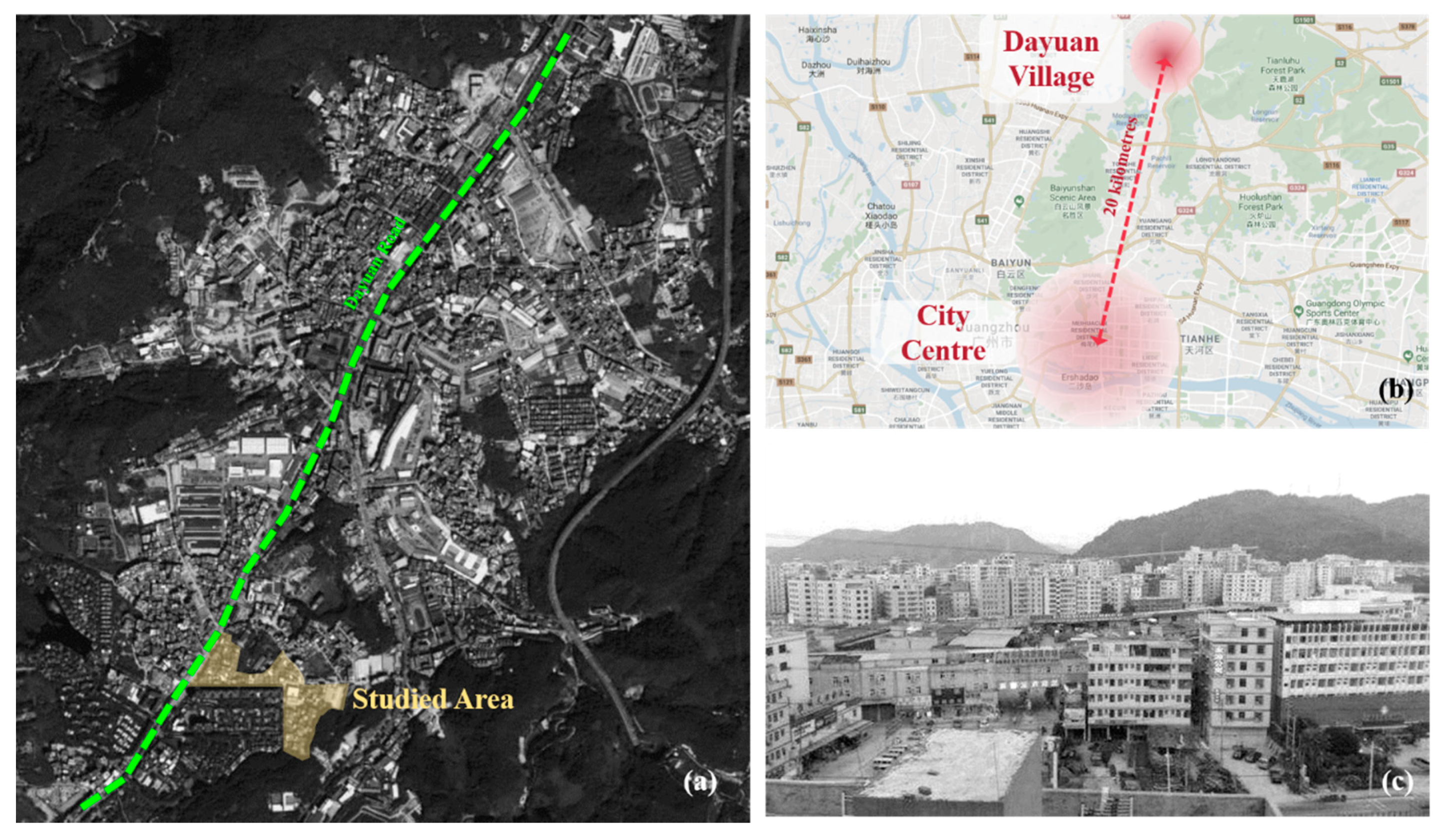
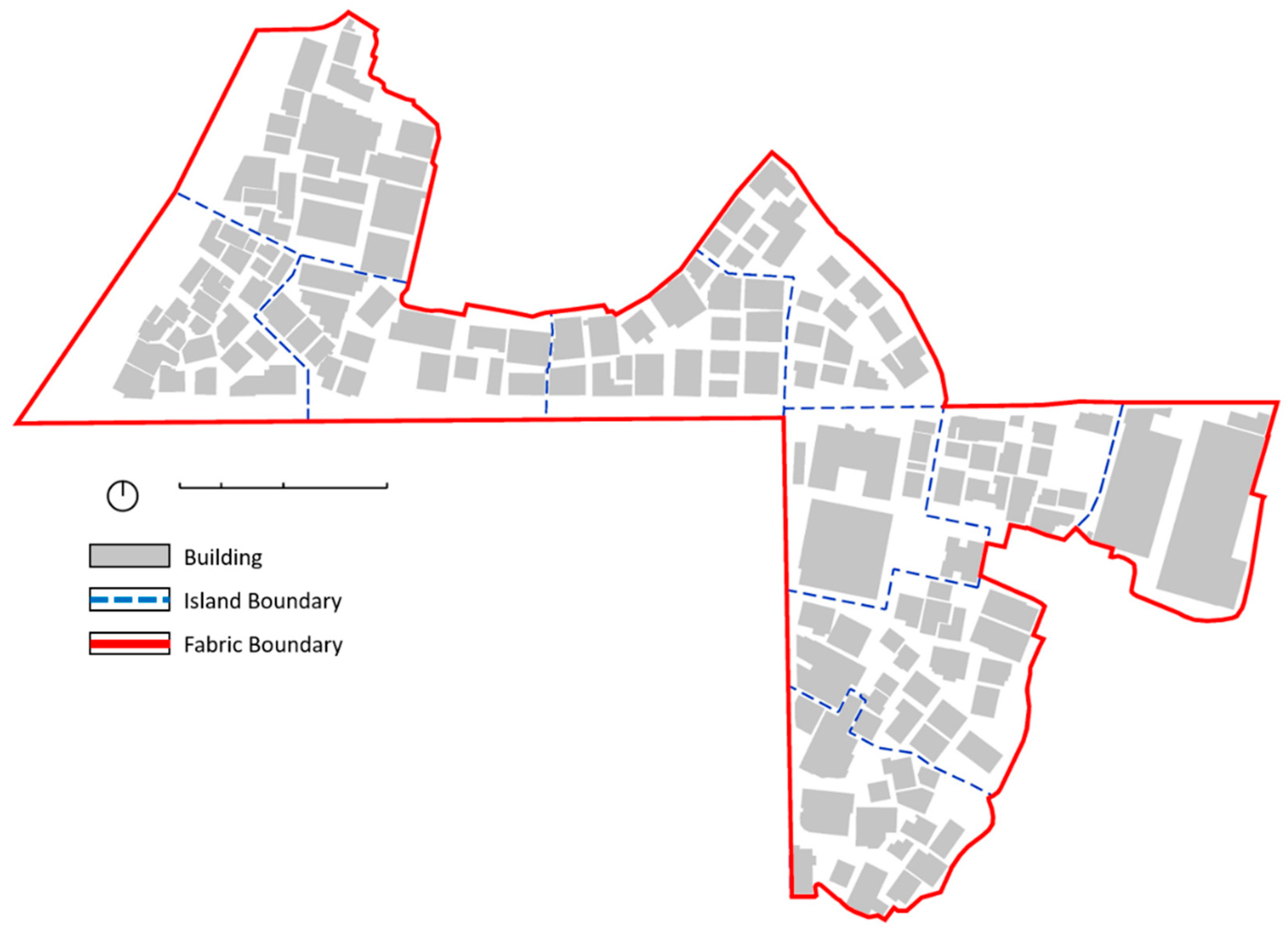
Dayuan Village is a suburban village and located in the north of the city centre. It is about 20 km away from the central business district of Guangzhou (
Figure 1). Traveling by public transport between Dayuan Village and the city centre takes one hour. For the micro-scale analysis of urban morphologies, the present research selects one of the areas with the highest building and population densities in Dayuan village. The location of the selected area is typical in relation to major transport corridors (i.e., Dayuan Road), through which Dayuan Village is connected to the metropolitan region of Guangzhou.
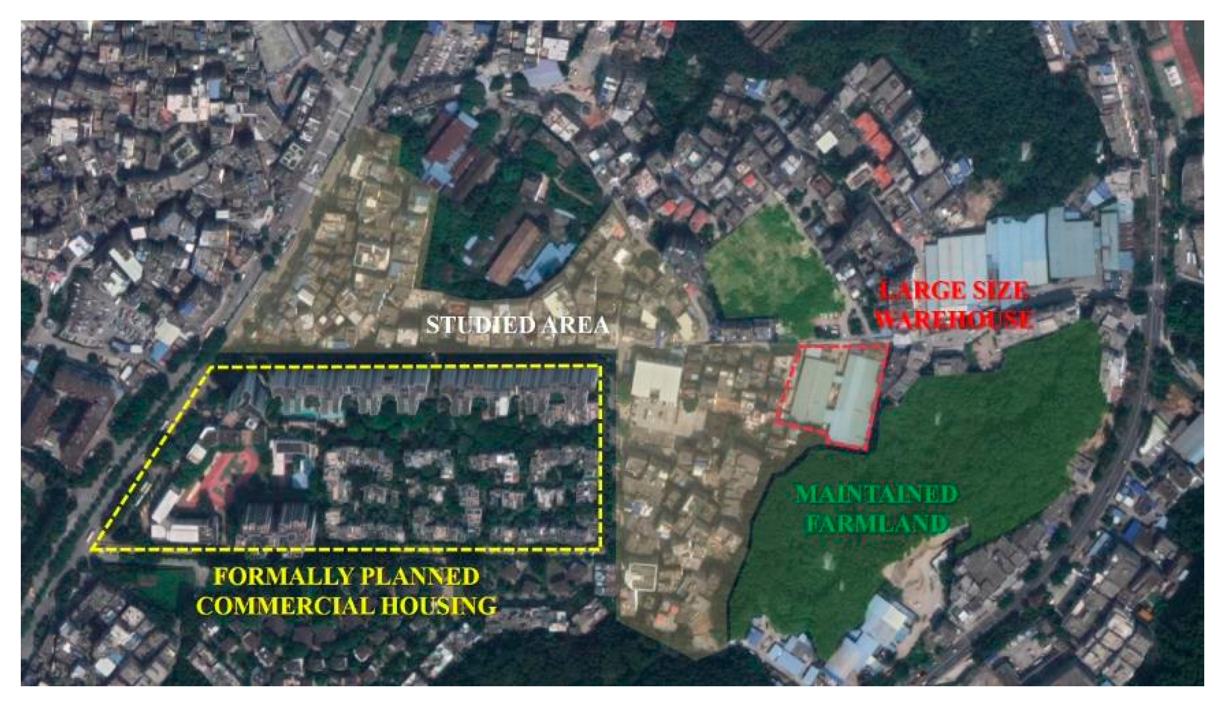
The land use of Dayuan Village reflects the characteristics of an urbanising village. Firstly, the village still maintains a small amount of farmland.
Figure 2 illustrates the distribution of maintained farmland in Dayuan Village. Secondly, the land of the village is being encroached by urban expansion. As shown in
Figure 2, a formal residential development has taken place in the south of Dayuan Village. The transformation of buildings to large size and low-end warehouses embodies the development of labour-intense industries. Hence, Dayuan Village is a typical suburban village of which the urbanisation process is affected by urban expansion and low-end industry.
Dayuan Village is a typical Taobao village in Guangzhou [
64]. ‘Taobao village’ is a concept describing the villages in which the development is driven by online shopping (Taobao is a large online shopping website in China). A village can be considered as a Taobao village when it reaches 10 million RMB in terms of the annual volume of e-business transactions or when it has over 100 active online stores [
65]. According to Guangzhou Urban Planning & Design Survey Research Institute (GZPI), the number of active Taobao stores in Dayuan Village exceeds 3000, which makes Dayuan Village the largest Taobao village in Guangzhou [
64]. Convenient transportation and adequate and well-equipped building space also provide a good foundation for Dayuan Village to develop into the largest and most representative Taobao village in Guangzhou. While Dayuan Village is an interesting case as discussed above, we do not claim that this village is representative of all urban villages in China. Urban villages are diverse, and each has its own unique characteristics. This study, we hope, is an endeavour to spark a debate on the morphology of urban villages.
3.2. Data Collection Methods
The data collection methods utilised in this paper consisted of archival records and visual recording. Archival records included planning reports and vector base maps. The planning reports were issued by the local planning authority and Ali Research Institute, which focus on the studies of Taobao villages. The quantitative data such as building storeys, the area of footprint of individual buildings, the length of building façades, and the distance of building setbacks were extracted from the vector base map. Visual recording was used to record the character of the site. Photographs were taken to illustrate the physical characteristics of buildings and the location and number of entrances. The building signboards captured in the photographs illustrate the function of each floor.
Table 1 summarises the collected data and data sources for each of the morphological elements. The photos were taken by the first author between the 2nd and 7th of July 2019 at Dayuan Village, Guangzhou. The satellite images were extracted from Tencent Map. The vector base map was prepared by the Guangzhou Urban Planning & Design Survey Research Institute in 2019.
3.3. Data Analysis Methods
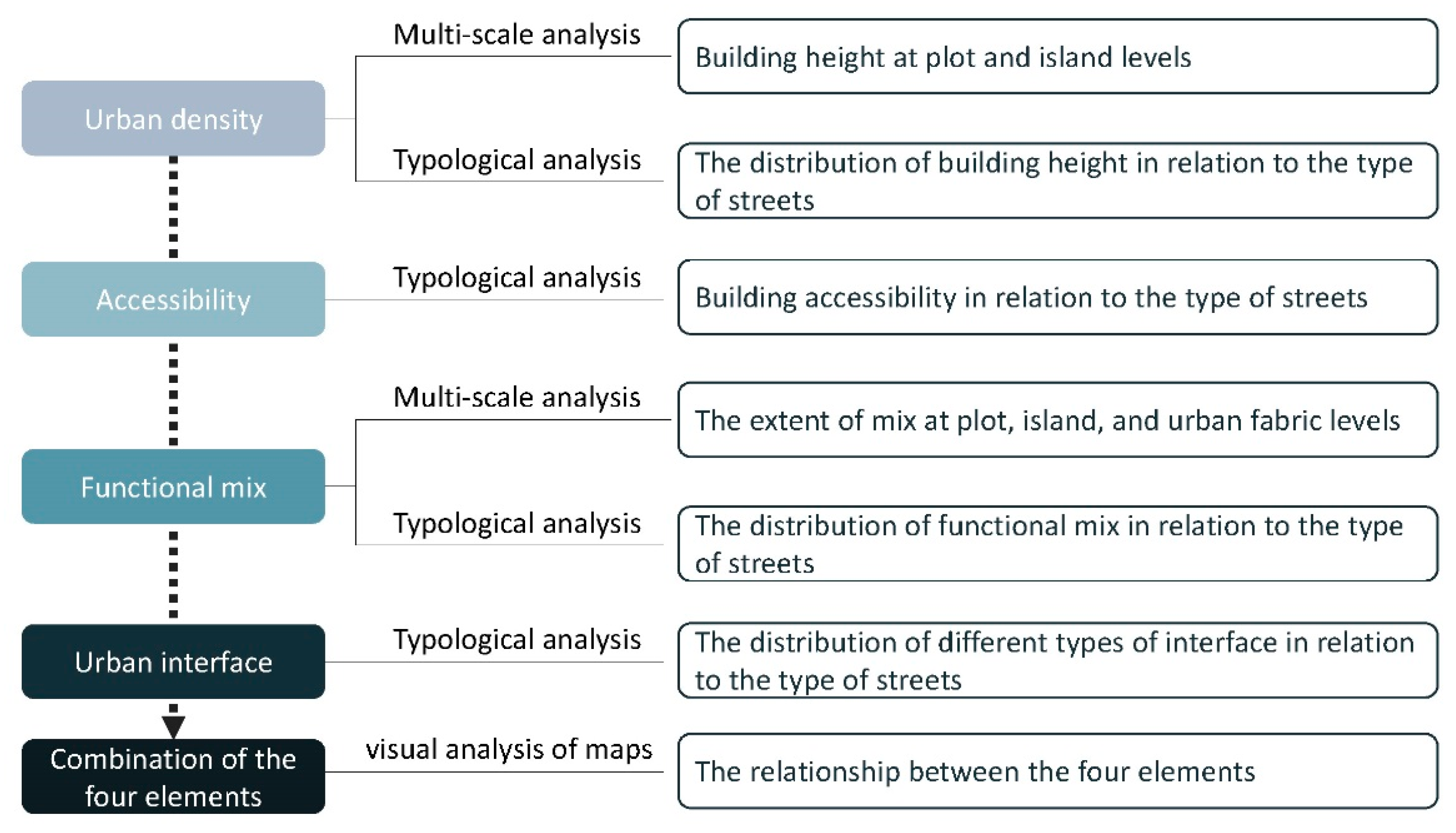
The data analysis methods consist of typological analysis, multi-scale analysis, and visual analysis of maps of density, accessibility, functional mix, and urban interface.
3.3.1. Typological Analysis
Typological analysis is one of the main analysis approaches in the present research. Kelbaugh [
66] argued that the typological analysis is a departure to discover spatial-related problems since types serve as abstractions rather than actual buildings. In the context of urban villages, where the physical form of buildings varies due to self-organised constructions, the typological analysis will help to reduce the disturbance of the greatly varied exterior of buildings. Proposed by Deleuze and Guattari [
67] and Dovey [
68], types can be considered as a diagram, which illustrates the relationships between different objects. In the context of informal settlements, the typology can be considered as a diagrammatic way to study how the urban morphology works [
69]. For the present study, typological analysis was applied to street, functional mix, and urban interface.
- (a)
Typology of street
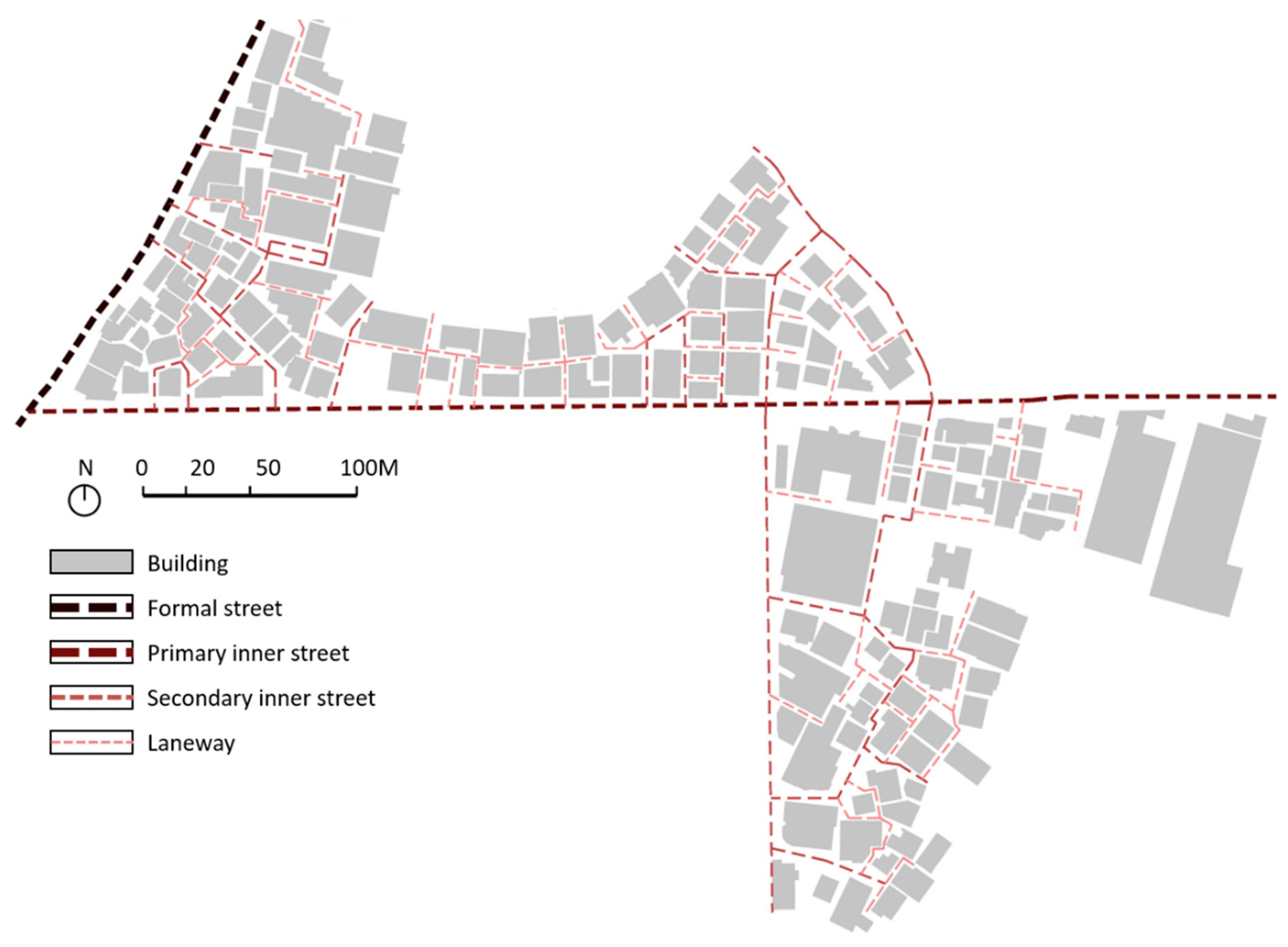
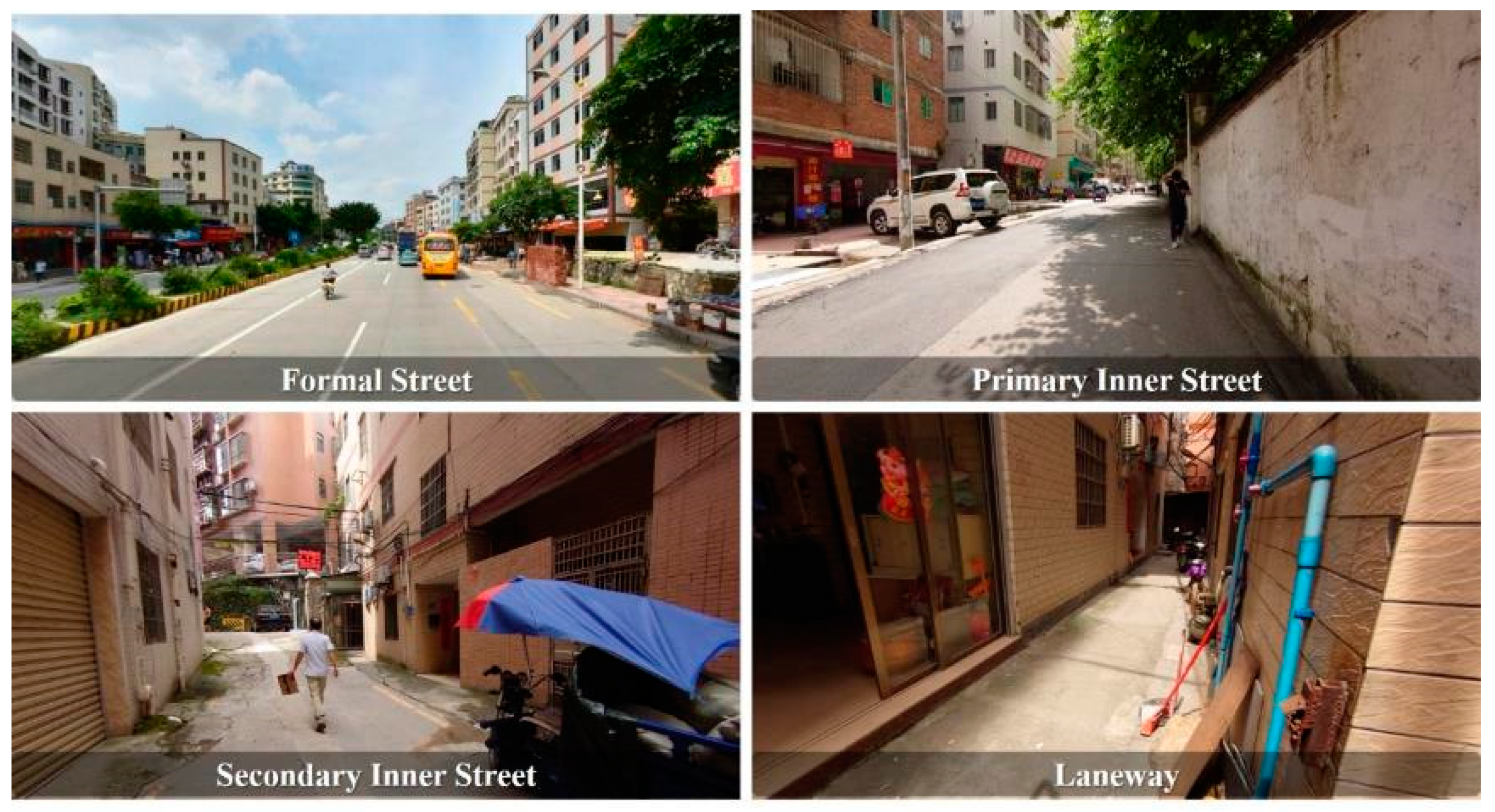
According to the formality, width, and connectivity, the streets within and surrounding the investigated area of Dayuan Village were categorised into the formal street, primary inner street, secondary inner street, and laneway (
Figure 3 and
Figure 4). The formal street represents the street that is planned and financed by the government. The formal street has higher traffic capacities. The primary and secondary inner streets and laneways are informally constructed by the village. Their capacities of vehicular traffic are lower, compared to the formal street. Primary inner streets are directly connected with the formal street and are wider than 6 m. The secondary inner streets are under 5.5 m. The laneways are the narrowest pathways, accounting for 2–4 m width. The laneways are linked to secondary inner streets and they have the lowest degree of connectivity.
- (b)
Typology of urban interface
Drawing on the typology of urban interface in informal settlement proposed by Kamalipour [
35], the urban interfaces were grouped into six categories: ‘impermeable/adjacent’, ‘accessible/adjacent’, ‘porous/adjacent’, ‘impermeable/distant’, ‘accessible/distant’, and ‘porous/distant’ (
Figure 5). Impermeable interfaces are those without any entrance. When up to half of the length of the interface is open to public space, it was defined as accessible. Porous interface required more than 50% of the total length to be opened. The threshold to distinguish adjacent/distant interface was set as 50 cm, since such distance provides a possibility to accommodate home appliances and activities such as sitting and socialising [
34]. If the edge of a building is more than 50 cm away from public realm, it was considered a distant interface. The distance between public space and adjacent interfaces were under half a metre.
- (c)
Typology of functional mix
The typological analysis of functional mix was based on the typology proposed by Hoek [
49] and Dovey et al. [
32]. The uses were categorised into seven groups: ‘live’, ‘work’, ‘visit’, ‘live/work mix’, ‘live/visit mix’, ‘work/visit mix’ and ‘mix’. Live, work and visit are three types of mono-functional uses. Live is the use for housing. Work describes the space in which the number of employees outweighs that of visitors and visit is on the opposite. Live/work mix, live-/visit mix and visit/work mix are three types of bi-functional mix. According to Dovey et al. [
32], live/work mix is about commute, live/visit mix is often related with lifestyles such as living and shopping in a given place and visit/work mix describes the way we shop, eat, and play in conjunction with work. Lastly, mix represents the space that mixes the three uses of live/work/visit.
3.3.2. Multi-Scale Analysis
Drawing on the framework of multi-scale analysis proposed by Berghauser Pont and Haupt [
39], the investigated area of Dayuan Village was analysed at the three levels of plot, island, and fabric. At the plot level, the unit of analysis is individual buildings. The island level constitutes adjacent plots and the public space around them. The shapes of islands are irregular due to the irregularity and high permeability of the layout of the investigated area. The size of an island is equal to the 80-to-90-m-wide block in the formal city, since the block width of 80–90 m enables accessibility, adaptability, and functional mix [
70]. Several primary and secondary inner streets were chosen as the boundary of island. In the fabric level, the unit of analysis was the investigated area as a whole. As shown in
Figure 6, the case study included 166 buildings and 10 islands.
3.3.3. Combination of Research Methods
The analysis was undertaken in a sequential manner (
Figure 7). First, in the analysis of density, building heights were measured in different scales. The relation between the distribution of building heights and the types of streets was analysed. Second, the density of building entrances and their relationship with the types of streets was analysed to illustrate the accessibility to buildings. Third, the extent of functional mix was measured at multiple scales. Then the impact of the types of streets on the building functions was analysed. The combination of typological analysis of street and urban interface illustrate the impact of the formality of streets on the form of urban interface. Finally, the visual analysis was carried out to analyse the interrelation between the four spatial elements.
4. Analysis
4.1. Urban Density
4.1.1. Plot Level
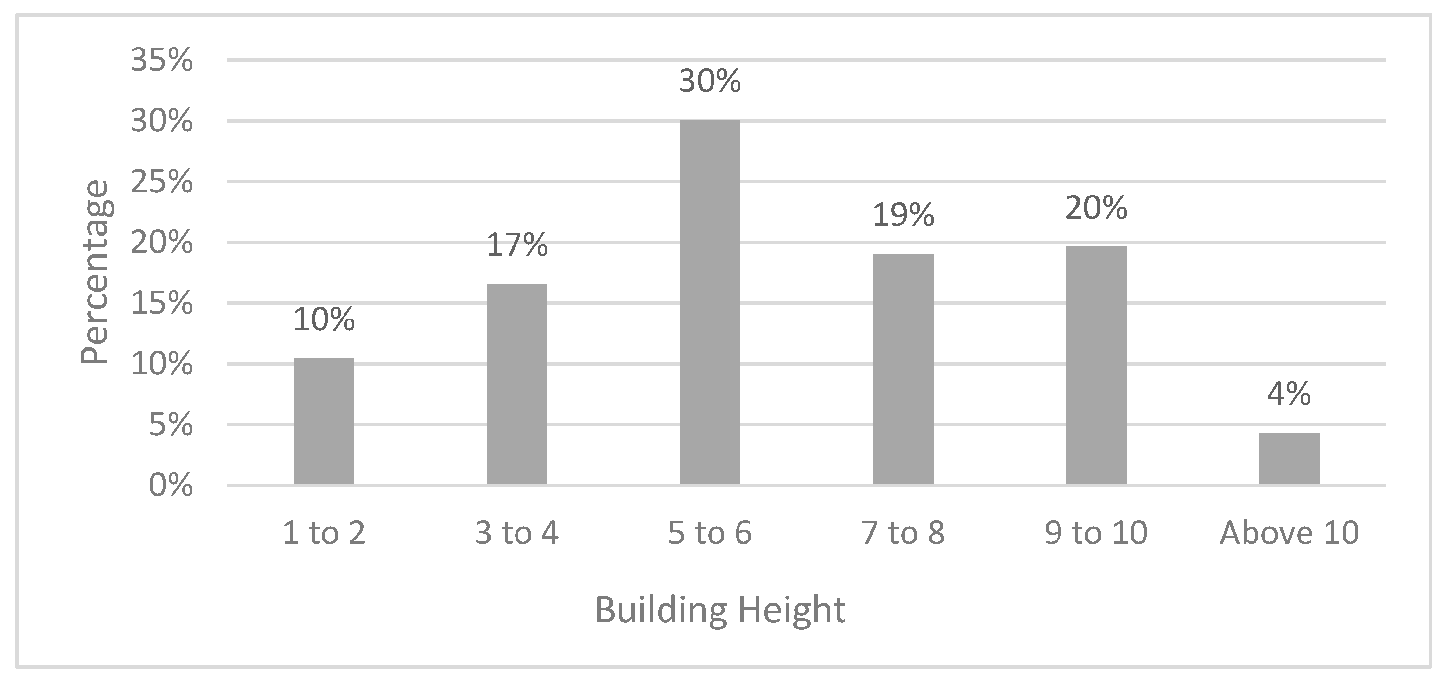
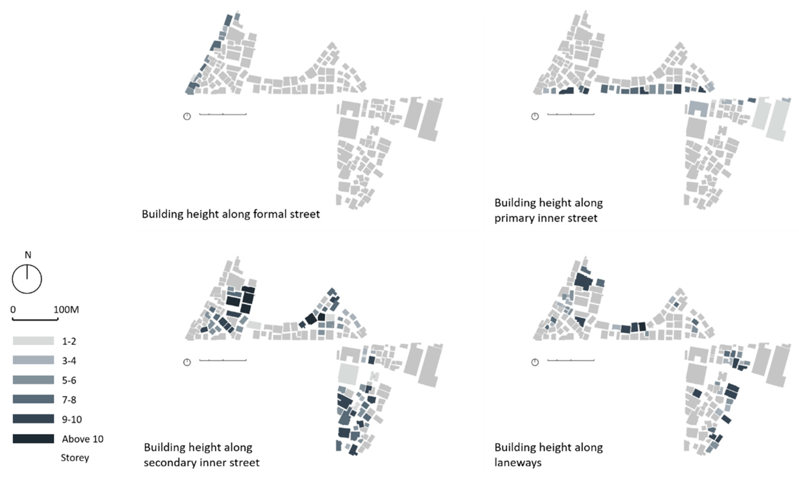
The building height in the study area (166 buildings) ranges from one storey to 13 storeys, with an average building height of 6.2 storeys (
Figure 8). According to Zacharias et al. (2013), the average building height of Shipai Village (a centrally located urban village in Guangzhou) is 5.06 storeys. Dayuan Village is located in the suburban area while Shipai Village is close to the central business district of Guangzhou. The difference between the average building height of the two villages is only one storey. It can be concluded that the centrality of the location has a limited effect on the average building height of urban villages.
Figure 9 compares the height of buildings with different types of street network, while
Table 2 exhibits the average storey number of the buildings along each type of street. The buildings located in the proximity of secondary inner streets and laneways have the highest average height (6.6 and 6.5 storeys, respectively). However, they are just one storey higher than those that are located along formal streets and primary inner streets. We can consider that the type of street has a limited effect on the height of the buildings. It is often expected that the centrality of streets affects land value, and consequently, increases the height of buildings in central areas. However, in the studied urban village, the height of buildings does not show any correlation with land values.
This might be because: (a) the central areas of the village were developed when the land values were lower; (b) although the land values of the central areas increased over time, the construction expenses and the informal nature of these settlements were hindering factors in rebuilding or adding more storeys to the existing central buildings; or (c) the building heights are the result of continuous coordination between villagers’ constructions and local planning regulations [
20].
Table 2 exhibits the average storey number of the investigated buildings and the proportion of different building heights. Moreover, the analysis also illustrates that the centrality of the urban village, formality, and traffic capacity of the streets have limited impact on building height.
4.1.2. Island Level
The investigated area was divided into 10 irregular sections at island level, of which the land coverage and gross floor area ratio (gFAR) are analysed. From the perspective of land coverage, most of the islands have a land coverage higher than 40. According to Guangzhou’s urban planning regulation of formal cities, the maximum coverage of residential, commercial, and industrial land stays at 30%, 50%, and 45% respectively. Although it is difficult to compare the investigated area with the regulation of formal cities due to the function’s dynamic in the urban village, the incremental construction drives the land coverage to go far beyond the norms of the local planning authority of Guangzhou.
In China’s land management system, the village’s land for housing is divided into plots and allocated to individual household according to population regardless of the consideration of public space [
8]. Kochan [
6] argued that there is no shortage of public space in urban villages since the definition of public space is extended to the places which facilitate chatting, sitting and other social and economic interactions, such as food markets, chess rooms, and other indoor spaces. However, the high land coverage, which is common in suburban and centrally located urban villages in the southern Chinese cities, proves the encroachment of publicly accessible outdoor space.
Four islands have gFAR higher than 2.0, two islands go beyond 3.0, and the other two islands exceed 4.0. These figures generally reach the same level as the gFAR in the central business district of Guangzhou, which is 2.7 [
71]. Although Dayuan Village is a suburban village, the gFAR of the ten islands shows that the construction density is equal to the city centre of Guangzhou. In a sense, the centrality of village has a limited influence on the density of space. Our analysis on land coverage and building height illustrates that the studied case reaches high construction density, which results in the encroachment of outdoor public space. However, this high density is merely linked to the geographic centrality or the formality of the external and internal street network.
4.2. Accessibility to Individual Buildings
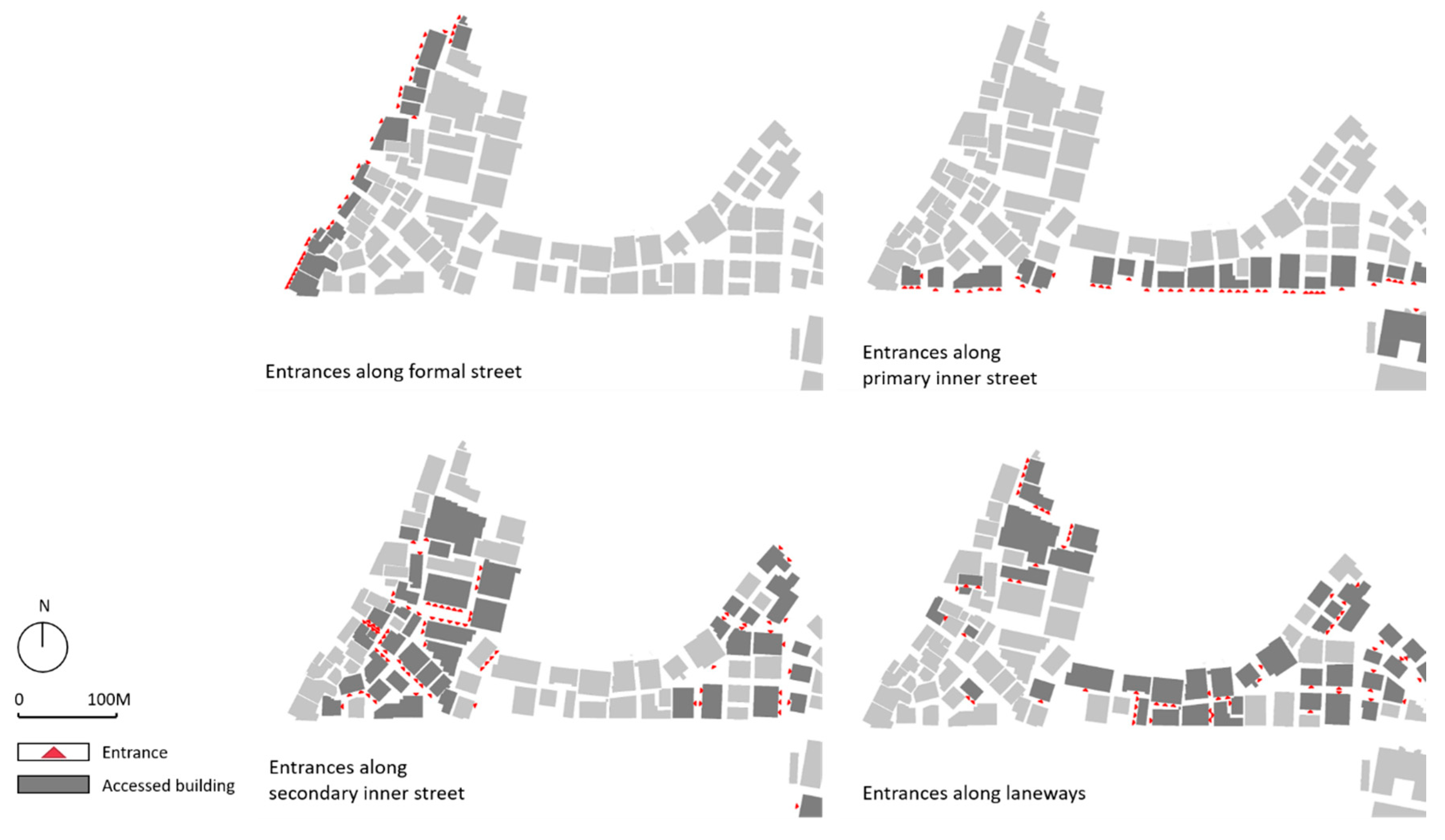
In the analysis of accessibility, the density of entrances is analysed according to different types of street network (
Figure 10). Among the four types of streets, the formal street has the highest density of entrances, accounting for 12.7 entrances per 100 m, and there is a big gap between the figure of the formal street with those of the other three informal street types (
Table 3). The density of entrances of primary and secondary inner streets and laneways decreases respectively with the decline of the connectivity compared to formal streets. It illustrates that the density of entrances is closely linked to the formality of the routes and the connectivity with the formally planned street.
The formal street is financed, constructed, and managed by the local government of Baiyun District. It has better traffic capacity and public transport facilities, such as bus stops and metro stations. Therefore, the formal street has a better connectivity with the city centre. This connectivity makes the formal streets the catchment of pedestrian flows, which facilitates the emergence of shops along the streets. In the buildings adjacent to the formal streets, the ground floor is generally divided into several independent shops. The high density of entrances of the formal streets is rooted in the connectivity with the formal city area.
In conclusion, although the spatial layout of the street network seems random and lacks a sense of hierarchy, the above analysis proves that accessibility is not evenly distributed. The density of entrances decreases with the decline of the streets’ width, formality, and connectivity. It proves that the formality and connectivity to formal streets have an impact on accessibility. The density of entrances can be considered as a variable measuring the street hierarchy within the urban village, in addition to street widths and connectivity to the formal streets.
4.3. Functional Mix
4.3.1. Plot-Level Analysis
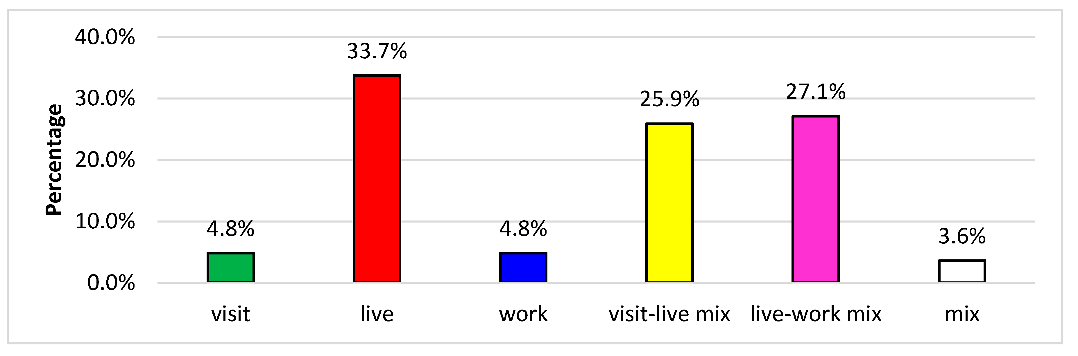
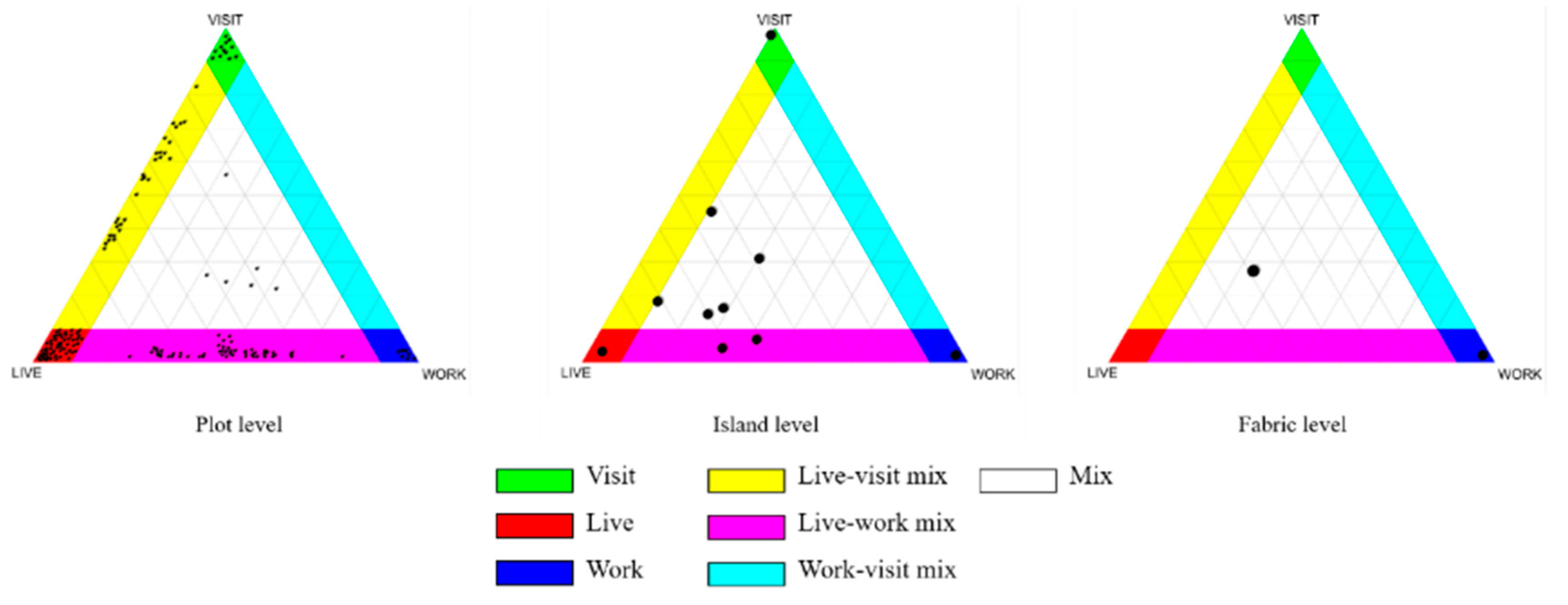
Figure 11 illustrates the proportion of the buildings in each type of mix. Among the three mono-functional uses, the buildings used for housing constitute the highest proportion at 33.7%, while the proportions of the buildings categorised as visit or work uses are both below 5%. The buildings with visit/live mix and live/work mix account for 25.9% and 27.1% respectively. The proportion of the buildings mixing the three primary uses of visit, live and work is the lowest at 3.6%.
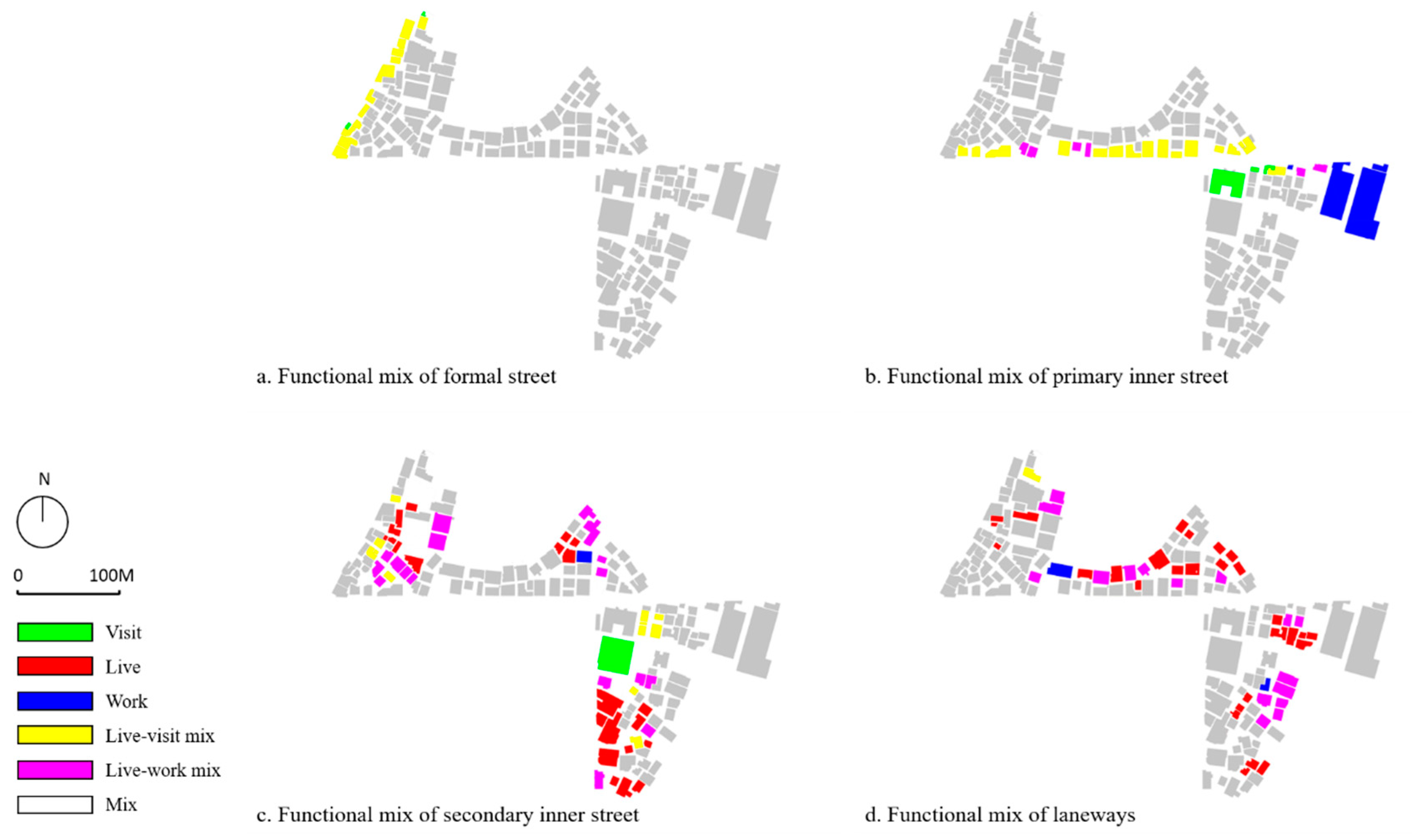
Figure 12 compares the functional mix of the buildings connected by different types of street network. Among the buildings located in the formal street, only two types of uses are found: the mono-functional use of visit and the bi-functional mix of live and visit. The latter has the highest share at 86.7%. In the buildings adjacent to the primary inner street, the blocks with a mix of live/visit still make up the highest proportion of 48.4% while the type of live/work mix accounts for 19.4%. Besides, the buildings used for work account for 16.1%. Within the buildings connected by secondary inner streets and laneways, the mono-functional use of housing accounts for the largest proportion of 40.8% and 55.1%, respectively. The second highest is the live/work mix, accounting for 33.8% of the buildings located in the secondary inner streets and 30.6% of those located in the laneways.
According to the above analysis, the proportion of the buildings with a live/visit mix declines with the shift from the formal street to the laneways. The shift of the street types suggests a decline of formality and connectivity. The decrease in the proportion of the live/visit mix is connected to the reduction of the formality and connectivity of the street. The proportional decline of the buildings with a live/visit mix can be explained from the vertical arrangement of functions. The ground floor is used for retail (e.g., supermarkets, restaurants, and shops), while the upper floors are generally used for residential units. These buildings are faced to the formal street and the primary inner streets due to the requirement for proximity to pedestrian flows.
Figure 13 illustrates that within the buildings reached by the secondary inner streets and laneways, the mono-functional use of live and bi-functional mix of live/work both occupy a share of over one-third. These buildings are located in the area where is distant to the formal streets and primary inner streets. This implies that the distribution of housing and live/work mix depends on the formality and the connectivity of streets.
In the formal city, however, the places for work are often concentrated in the areas with a strong accessibility to transport facilities. The main difference between the distribution of spaces for work in formal and informal settlements stems from the specific content of ‘work’. For the present research, the spaces for work consists of industrial development of logistics and warehousing, which require large spaces, low rents, and vehicular accessibility. Due to the higher rents of the buildings in the proximity of the formal streets, the live/work mix use is pushed to the areas which are away from the formal and primary inner streets but provide vehicular accessibility.
4.3.2. Multi-Scale Analysis
The multi-scale analysis compares the extent of the mix at the three levels of plot, island and fabric. As shown in
Figure 14, five islands reach a mix of three primary uses, and two islands provide a mix of live and work. At the fabric level, the investigated area has a balanced ternary mix, which implies that the three primary uses share a similar proportion. The investigated village provides diverse uses within a walkable scale. It also supports the argument of Hao, et al. [
5] that the urbanising villages tend to have a high diversity of land uses.
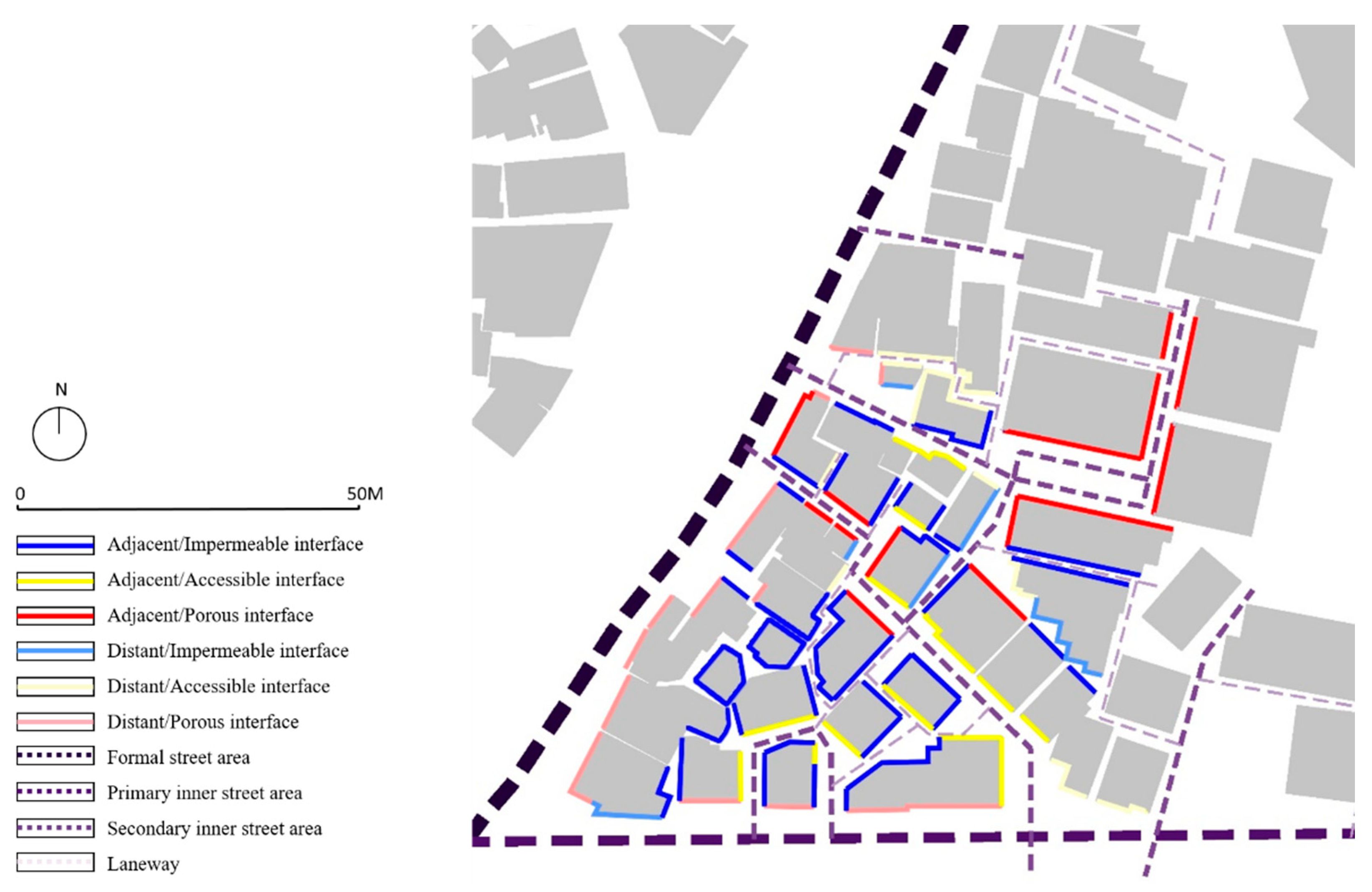
4.4. Urban Interface
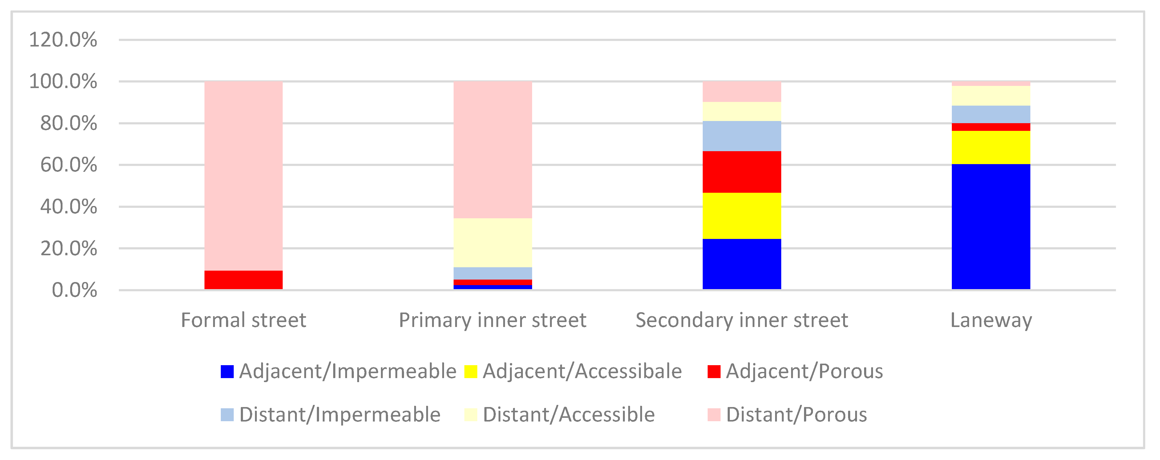
Figure 15 shows the proportion of the length of different urban interfaces. In the four types of streets, the proportion of each type of interface varies significantly. First, in the formal street there are only two types of urban interfaces: adjacent/porous and distant/porous. The latter accounts for a large proportion of 90.6%. Second, in the primary inner streets, although the diverse types of interfaces emerge, the distant/porous interface still constitutes 65.5% of the total length, which is much higher than the other four types. Third, in the laneways, the adjacent/impermeable interface makes up 60.4% of the total length. The second-highest proportion of adjacent/accessible interface is much lower, accounting for 16%. By contrast, the gap between the six types of interfaces in the secondary inner streets is not as significant as those in the formal streets, primary inner streets and laneways. The adjacent/impermeable interface constitutes 24.6% of the total length while the adjacent/accessible and adjacent/porous interfaces account for 22.2% and 19.9% respectively.
Figure 15 exhibits the trend of how these two variables change. In terms of the connectivity, with the shift from formal streets to laneways, the proportion of porous interface decreases whilst the proportion of impermeable interface raises, and the proportion of accessible interfaces is relatively stable (about 20%). In terms of proximity, the proportion of distant interfaces decreases from formal street to laneway, while the proportion of adjacent interface rises. This trend is also revealed by spatial distribution. As shown in
Figure 16, the distant and porous interface is mainly located along the formal and primary inner street, while the secondary inner streets and laneways are embraced by the adjacent and impermeable interfaces.
As discussed above, the four types of streets are formulated based on the formality and connectivity to the formal street. The shift from the formal street to the laneway suggests the reduction of formality and connectivity with the formal street. Therefore, the proportion of different types of interface illustrates the way in which the street’s formality and connectivity affect the physical form of the interface in the urban village. The porous of interfaces occur in the street with intense formality and connectivity.
It has been argued that porous forms of interface facilitate the interaction between public and private space [
56], and the distant interface provides more semi-public or semi-private space, which benefits the social activity in outdoor spaces [
60]. This is the point where the formality of street, the form of interface, and street-life intensity can be connected. Through affecting the physical form of the interface, the formality of streets has the capacity to facilitate street-life intensity in urban villages.
4.5. The Relationship between Density, Accessibility, Functional Mix, and Urban Interface
The relations between density, accessibility, functional mix, and interface at island level are analysed using the maps. Two islands that are located next to the formal street are chosen as samples (
Figure 17).
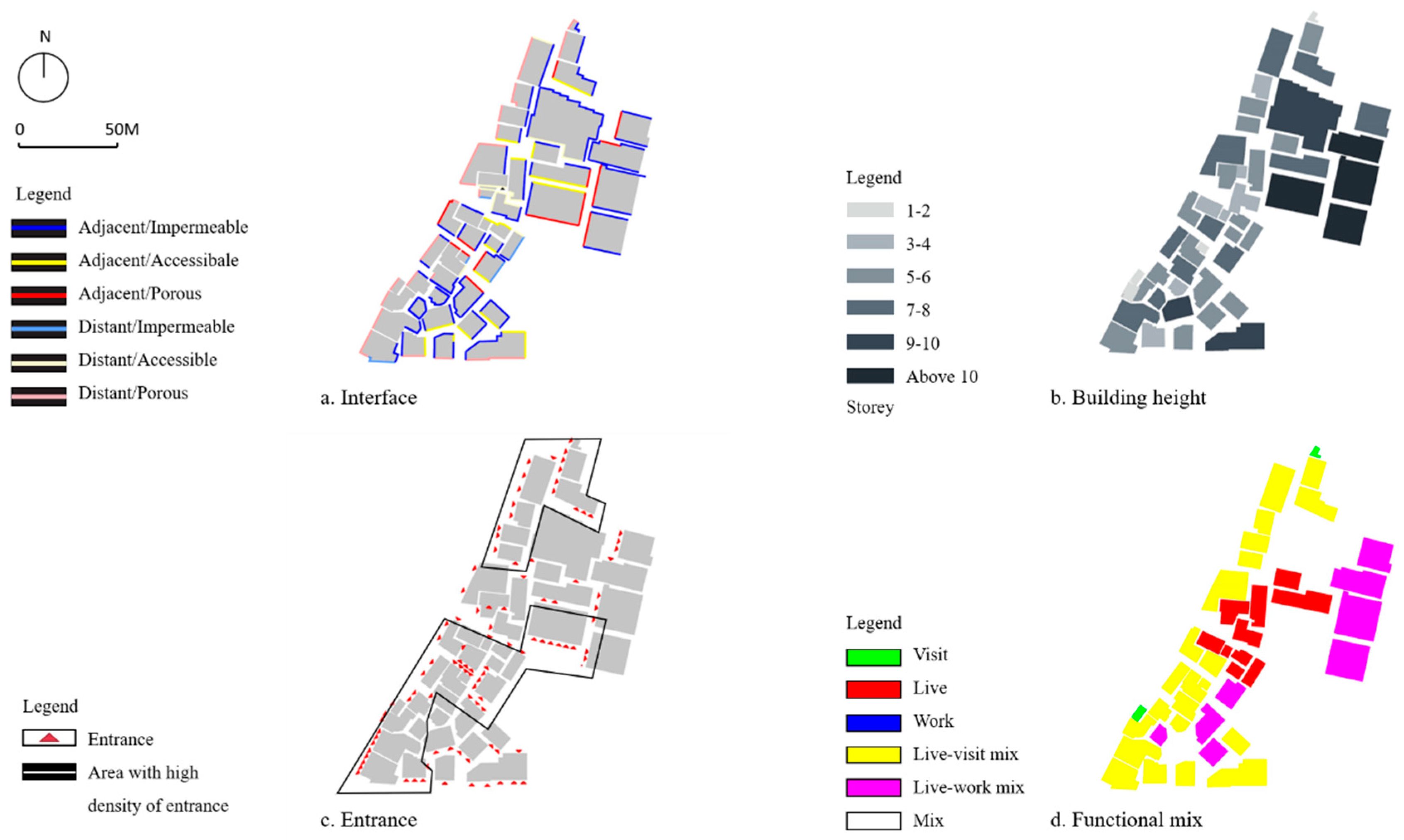
Figure 18 highlights the high density of entrances in the two islands. There is an average of 20.5 entrances in every 100 m. The reason why these buildings have a higher density of entrances is linked to the functional mix of architectural infill. The buildings in these areas generally have a vertical mix of live/work, live/visit, or live/work/visit. The ground floor is divided to provide separate entrances for different functions. For example, in the buildings with a live/work mix, one entrance is for the apartments on upper floors and the other entrance is for stores on ground floors.
The density of entrances also increases the porosity of urban interfaces, whilst improving the exchange between the public and private spaces. The form of these interfaces is either porous/distant or porous/adjacent. The porous/distant interface is often found on the ground floor of the buildings with a live/visit mix. The transitional space in front of these buildings is semi-public equipped with movable chairs, in which people can sit, rest, and talk. The building with a live/work mix tends to have a porous/adjacent interface. As the logistic industry is a key driver in the development of the village, the building function of ‘work’ is mainly referred to the use by the warehouses or the offices of logistic companies. Since moving goods requires reducing the distance between indoor and outdoor spaces, the buildings with a live/work mix are rarely confronted with a transitional space. The spaces in front of these buildings are often used as car parking to facilitate loading and unloading goods. In conclusion, in the studied area, the functional mix of buildings increases the density of entrances and thus improves the porosity of the urban interfaces.
5. Summary and Conclusions
This research aimed to develop a better understanding of the ways in which the informal settlements of urban villages operate in terms of urban morphology. Our analysis showed that three elements of urban morphology (i.e., accessibility, functional mix, and the urban interface) are moderated by centrality of the streets or street types (i.e., formal street, primary inner-street, secondary inner-street, and laneway), but the only element that has not been affected by these types is urban density.
Regarding urban density, the average building height of the investigated area is higher than those located in the central villages-in-the-city in Guangzhou. This demonstrates that centrality has potentially limited influence on building density of the urban village. Moreover, the heights of buildings are not directly influenced by land value. However, they can be associated with landowners’ economic power and depend on the agreement between the village committee and local government. The land coverage ratio in this village also exceeds the planning regulation on residential districts. The gFAR of the investigated area reaches the same level as the central business district (CBD) of Guangzhou. The great land coverage ratio and gFAR leads to the encroachment of public spaces in an urban village. The density of entrances was found to be aligned with the type of streets (i.e., formal street, primary inner-street, secondary inner-street, and laneway). By transitioning street types from laneway to formal streets, the number of streets was increasing.
Regarding functional mix, within the investigated area, the mono-functional use of ‘live’ and bi-functional mix of ‘live/visit’ and ‘live/work’ constitute a large proportion of the total number of buildings. The distribution of different types of functional mix is moderated by typology of streets. The buildings with a mix of ‘live/visit’ are concentrated along formal streets and primary inner streets which have the highest connectivity to the formal streets. The mono-functional use of ‘live’ and the bi-functional mix of ‘live/work’ are found to be accommodated in secondary inner street and laneways. At the scale of 80–90-m-wide blocks, five blocks mix the three primary uses of ‘live’, ‘visit’, and ‘work’. Two blocks are bi-functional of ‘live/work’ mix and ‘live/visit’ mix, and only three blocks are mono-functional. Regarding urban interface, the proportion of different types of interface varies between the four types of streets. Only two types of interface are found in the buildings along formal streets: adjacent/porous and distant/porous with the latter constituting a large proportion, whereas five types of interface are found in primary inner streets (adjacent/porous, adjacent/impermeable, distant/porous, distant/accessible, distant/impermeable), distant/porous still accounts for the highest proportion. There are six types of interface in secondary streets, and the proportional gap between them is narrow. Three interfaces of adjacent/porous, adjacent/impermeable, and adjacent/accessible have a small proportion, about 20%, while the other three types of distant interfaces are all below 15%. At last, the laneway is mostly constituted of adjacent/impermeable interfaces. Therefore, formal streets often have an interface with considerable porosity and weak proximity. This can contribute to the livelihood of streets. Our analyses also show that the porosity of interface and the density of building entrance are linked to the functional mix. The buildings with a mix of live/work or live/visit often have several separate entrances for different functions, which increases the density of entrances and the porosity of the interface, and thus provides opportunities for the interaction between public and private spaces.
This paper suggests that the framework, which has been tested in this paper to evaluate the urban morphology of the Dayuan urban village, can be used to inform how to apply this framework to the morphological study of other urban villages. The proposed framework consists of urban density, accessibility, functional mix, and the urban interface. Despite its fair level of analytical generalisability, this research is limited to the study of a single case study of a suburban village. Similarly, there are several approaches to analysing urban morphology, and each approach has its own limitations including the approach that has been utilized in this study. We suggest that the study of urban morphology in different types of urban villages, using different approaches, would be a fruitful and helpful area for further research. Such studies can reveal the differences between the morphology of different urban villages, whilst developing a better understanding of the effects of formal cities on the development of these settlements.


