Article

Assessment of Water Quality as a Key Component in the Water–Energy–Food Nexus

1
Hydrology and Water Management Research Center, National Institute of Geophysics, Geodesy and Geography, Bulgarian Academy of Sciences (NIGGG-BAS), Acad. G. Bonchev Str., bl. 3, 1113 Sofia, Bulgaria
2
Department of Geography, National Institute of Geophysics, Geodesy and Geography, Bulgarian Academy of Sciences (NIGGG-BAS), Acad. G. Bonchev Str., bl. 3, 1113 Sofia, Bulgaria
*
Author to whom correspondence should be addressed.
Hydrology 2024, 11(3), 36; https://doi.org/10.3390/hydrology11030036
Submission received: 22 January 2024 / Revised: 21 February 2024 / Accepted: 27 February 2024 / Published: 29 February 2024

Abstract

:
The intensive economic activity along the Bulgarian Black Sea coast is causing serious changes in the quality of the river water. In view of the topicality of the problem, the main goal of this article is to emphasize the water quality as a necessary key component in the water–energy–food nexus by determining the status of the surface waters of selected Bulgarian Black Sea tributaries from the point of view of their physicochemical characteristics. The research is based on the Water Framework Directive (WFD)—2000/60/EU and the relevant national legislation. In the present study, the Canadian Complex Water Quality Index (CCME, WQI) was applied to determine the quality of river waters. The novelty in the present study is a definite and necessary emphasis on the opinion that the analysis and assessment of water quality should become an integral part of all studies of the water–energy–food nexus.

1. Introduction

The role of water as a component of the global ecosystem is becoming increasingly important. It is a resource that sustains life on earth, provides the basic needs of the population, and is a major factor in the development of the economy—agriculture, energy production, industry, transport and tourism, fish trade, etc. A wide range of factors (natural and anthropogenic) influence the quality of water bodies. Deterioration of the quality characteristics of water (including river water) has a negative impact on its economic, social, and ecological role [1]. For this, it is necessary to prepare and utilize a comprehensive multi-level policy between the responsible institutions, identifying the common factors that allow integrated management of the water–energy–food components.
When preparing the nexus assessments, the two main components of the sustainable development of society must be taken into account—human well-being and environmental protection. A nexus concept, which combines management and governance across sectors and scales, can lead to improved water, energy, and food security. A nexus approach can additionally help with the shift to a green economy, which aspires for resource efficiency and increased coordination of policies [2]. However, synergies between the achievement of economic, water, energy, and food security goals and the related role of water quality are still less prominent in national policies and laws. Nowadays, protecting the quality of water sources in Europe is a key priority for the European Union (EU). A fundamental document in the field of water policies is the Water Framework Directive, which establishes the legal framework for protecting and restoring the purity of water bodies in Europe and ensuring their long-term and sustainable use. The Directive creates an innovative approach to water sector management based on river basins.
Rivers are the most important water resource for domestic, industrial, and irrigation purposes, which are fundamental to human development. However, rivers are polluted due to the discharge of sewage and industrial waste and the implementation of various human activities that affect their physicochemical quality. The protection of the natural ecological environment, including the quality of flowing surface water and the creation of favorable conditions for meeting water needs, are determined by the goals of water consumption and the requirements of water users. This applies to the waters of all rivers in the Republic of Bulgaria, including the Bulgarian Black Sea tributaries. With connection to that mentioned above and the lack of many analyses about the physicochemical status for the Black Sea tributaries and the novelty of the nexus approach for our country, the present analysis is needed.
The main goal of this article is to emphasize water quality as a key component in the water–energy–food nexus by determining the status of the surface waters of selected Bulgarian Black Sea tributaries (Batova, Dvoinitsa, Aheloy, Dyavolska, and Rezovska rivers) from the point of view of their physicochemical characteristics for the period from 2015 to 2021.
The quality of water in river basins reflects to a significant extent the origin, intensity, and extent of anthropogenic impact on the environment. The rivers subject to the present research fall within the scope of the Black Sea Basin Management Region in the country. It is characterized by the developed economic activity, the diverse characteristics of land use, the different methods of discharge of untreated or insufficiently treated wastewater from the settlements, etc. In this sense, in order to have the maximum benefit from water as a natural resource, it is necessary to use and manage it in a sustainable way.

2. Materials, Data and Methods

2.1. Study Area

The Black Sea is a natural inland water basin located between Europe and Asia. The catchment area of the Black Sea is about 2.5 million km2, and about 160 million people, almost half of them from offshore countries, indirectly and even unconsciously influence the Black Sea ecosystem [3].
Along the Bulgarian Black Sea coast, a well-defined economic zone has been formed, in which agriculture, industry, energy, tourism, etc., are developed. Intensive human activity adversely affects the natural environment, and river discharges are a critical factor influencing the functioning of the marine ecosystem.
The coastal marine environment is rapidly changing in space and time. The rivers selected for analysis in the present study—Batova, Dvoinitsa, Aheloy, Dyavolska, and Rezovska—in a territorial aspect are part of the Black Sea Basin Management Region, which covers about 15% of the land territory of the Republic of Bulgaria and 100% of its water area (Figure 1).
The Batova River is located in northeastern Bulgaria, within the borders of the Varna and Dobrich regions. It has a length of 38.7 km. The valley at its mouth is occupied by the “Baltata” forest and the Batovsko Blato estuary. The Batova River is the only Dobrudja river with a permanent outflow. The catchment area of the river is 338.8 km2. There are five villages located along the river—Dolishte, Batovo, Tsarkva, Obrochishte, and Kranevo. The waters of the river in the lower reaches are mainly used for irrigation.
The Dvoinitsa River is a river in eastern Bulgaria and flows through the Varna and Burgas regions. Its length is 52 km. The catchment area of the river is 479 km2. Along the course of the river are located one town, Obzor, and two villages, Koznitsa and Popovich. In the middle and lower reaches, the waters of the river are used for irrigation.
The Aheloy River is a river in southeast Bulgaria in the Burgas region. It is 39.9 km long. It flows into the Black Sea at the Aheloy campsite, 1.2 km south of the town of Aheloy. The catchment area of the river is 141 km2. Along the course of the river are located one town, Aheloy, and three villages, Draganovo, Medovo, and Aleksandrovo. The river waters are mainly used for irrigation, with the Aheloy Dam built along the river.
Dyavolska is a river in southeast Bulgaria in the Burgas region, flowing into the Devil’s Bay on the Black Sea. Its length is 37 km. The catchment area is 133 km2. One village, Yasna Polyana, and one town, Primorsko, are located along the course of the river. A dam called “Yasna Polyana” was built along the course of the river, the waters of which are used for drinking water supply and for irrigation of agricultural lands.
The Rezovska River flows through Turkey and Bulgaria, its length is 112 km, and almost along its entire length, it serves as a border between the two countries. Its catchment area is 738 km2, of which 183 km2 is on Bulgarian territory. In general, the river flows through uninhabited territories, and the Bulgarian village of Rezovo is located at its mouth [4].

2.2. Materials

In the present article, in the relevant sections, literary sources are used for the theoretical part, and in the analytical section, several administrative-legal documents are used. Literature sources are scientific articles and publications with an emphasis on the water–energy–food concept. Regarding the determination of water quality, the analysis and assessment are based on the requirements for achieving “good” river water status as defined in the Water Framework Directive (WFD)—2000/60/EU, and at the national level, the current topic of discussion is aligned with the Water Act. Announcement, SG No. 67 of 27 July 1999, in force since 28 January 2000.

2.3. Data and Legislation

For determining the water quality of the selected study area, the present study was based on the analysis of the values of 10 parameters: pH, electrical conductivity (EC), dissolved oxygen (DO), ammonium nitrogen (N-NH4), nitrate nitrogen (N-NO3), nitrite nitrogen (N-NO2), total nitrogen (N-Total), total phosphorus (P-Total), orthophosphates (P-PO4), and BOD5.
The study used verified data from the National Monitoring Network provided by the Executive Environmental Agency (ExEA) to the Ministry of Environment and Water (MOEW) for fourteen monitoring points of five Bulgarian Black Sea tributaries. According to national legislation requirements, all analyses were performed in accredited laboratories every month. The sampling stations presented in Table 1 and Figure 1 were initially selected to achieve the purpose of the present study. After that, due to the review of specificity and the completeness of the primary source data, the sampling station RZV was not taken into account during the analysis process.
In the studied area are developed agricultural activity and animal husbandry, tourism, and industrial production. The types of the relevant water bodies are presented on Table 2 [5]. The period of the study was 2015–2021. The complex and differentiated evaluation of the physicochemical status of studied river basins was based on Ordinance No. N-4/14.09.2012 (concerning the characterization of surface waters) in accordance with Directive 2000/60/EU (Water Framework Directive) [6,7]. The obtained results for water quality are considered key components in the water–energy–food nexus.

2.4. Methods

In this scientific article, the analysis and synthesis of literary sources and cartographic and mathematical-statistical methods are applied. The collection, accumulation, and preliminary processing of the information received from scientific publications, manual documents, official sources of information, as well as the familiarization and application of the necessary administrative documents, i.e., directives, laws, and regulations from the legislation in force in the EU and Bulgaria, represent the initial methodical stage in the development of the problem set. To visualize the study area, the cartographic method was applied, which provided up-to-date and qualitative information about the formed natural-anthropogenic systems [8].
The Canadian Complex Water Quality Index was used to determine the quality status of the selected Black Sea tributary rivers. The CCME WQI is a science-based communication tool that tests multivariate water quality data against certain user-defined criteria. The CCME WQI model does not specify exactly which parameters should be applied. The CCME WQI mathematically combines three variables characterizing the impact on water quality (range, frequency, and amplitude). The impact range (F1) expresses the range of quality indicators whose values do not correspond to the normatively determined equation below:
F 1 = m M × 100
Here, m is the number of quality indicators with cases of deviation from the norms, and M is the total number of quality indicators used in the calculation of the index.
The frequency (F2) shows the ratio between the number of so-called “bad samples” (samples in which the content of a potential pollutant with a content above the reference values was detected) and the total number of samples:
F 2 = n N × 100
where n is the number of all samples deviating from the reference values, and N is the total number of samples used in the calculation of the index.
The amplitude (F3) represents the degree or multiplicity of deviation of the values of the “bad sample” from the corresponding normative values and is calculated by a three-step algorithm as follows: at the beginning, the magnitude of the deviations Ei of the so-called “bad samples” from relevant regulated meanings:
( a )   E i = v i V P L i 1
or
( b )   E i = V PL i v i -   1
vi denotes the value of the “bad” sample, and VPLi is the reference value of the maximum permissible concentration (norm) for the corresponding quality indicator. The second formula (b) is applied to calculate the amplitude of indicators whose reference values decrease when moving to a worse category (for example, dissolved oxygen content). The normalized sum of deviations NSE is then calculated:
N S E = i = 1 n E i N ,
where the corresponding symbols match those of the above formulas. The final formula for determining the amplitude F3 is calculated as follows:
F 3 = NSE 0.01 × NSE   +   0.01
After obtaining the values of the individual components of the integrated formula, the calculation of the water quality index (WQI) itself is performed by means of the following:
W Q I =   100   - F 1 2 + F 2 2 + F 3 2 1.732
Here, the divisor 1.732 normalizes the obtained value in the interval from 0 to 100, where 0 means the “worst quality” and 100 the “best quality” of water.
According to the water quality, its status was differentiated into the following groups: excellent (WQI = 95–100, the waters are in a natural state); good (WQI = 80–94, single cases of contamination are registered); fair (WQI = 65–79, waters are defined as lightly polluted); marginal (WQI = 45–64, water quality is often recorded as deteriorating); and poor (WQI = 0–44, the water quality is not suitable for use for any purpose) [9].
According to Bulgarian legislation, harmonized with the European legislation through the WFD, the characterization of the state of river waters based on physicochemical parameters was carried out in three categories—moderate, good, and very good. In the subsequent calculations, the standard approach of the CCME-WQI was comparable to the adopted reference values set out in the Bulgarian regulatory documents for “good” condition of river waters.
The Canadian Water Quality Index (CCME, WQI) has a number of application advantages, including the relative simplicity of application, the flexibility provided in both the selection of water quality parameters, and the ability of the index to represent measurements of different variables in one number, the possibility to combine different measurements with different measurement units, tolerance in cases of missing data, the establishment of a general status of water bodies, the easily comparable results for separate periods and sections and entire river basins, information on the leading polluting substances, and the extent and intensity of pollution and how it spreads in time and space as derived from intermediate results. Essentially, the index is not designed to replace detailed analysis of variables but rather serves as an aid to management decision making and representation of overall water quality.

3. Results and Discussion

3.1. Water–Food–Energy Concept—A Brief Overview

The water–energy–food nexus is a framework increasingly used by researchers to promote policy making to address global, national, and regional challenges that require a multidisciplinary and cross-sectoral approach [10,11]. The water–energy–food relationship is not static and must take into account the needs of the ever-changing global world, which reflect on the demand for the three components. The achievement of Sustainable Development Goals (SDGs)—specifically SDG 2 in the achievement of zero hunger, SDG 6 in the provision of clean water and sanitation, and SDG 7 in affordable and clean energy—represent in practice the degree of the development and realization of nexus thinking [12]. The water–energy–food concept describes interactions among domains that yield gains or trade-offs when analyzed together rather than independently [13]. In the modern world, economic benefits drive the design and implementation of policies for the management and use of resources in the water–energy–food nexus. Although the current thinking of society supports the notion that money is the basis of its development, having a balanced, functioning water–energy–food nexus is the indispensable and necessary condition for its existence, not the other way around [14]. The case studies of the water–energy–food nexus reviewed in the scientific literature show that it has different scales (household, catchment area, and region) and impacts from different point and diffuse sources. This defines it as markedly transdisciplinary and dynamic, developing in time and space. The main objective of the nexus concept is to increase the net benefits of using water resources for food production, water supply, and energy provision while minimizing trade-offs in the relationships between the three components of the nexus. The main goal of the nexus concept is to maximize the net benefits of using water resources for water production, water supply and energy generation, while minimizing compromise is in the relationships between the three components [15].

3.2. Consideration of Water Quality as a Key Point within Water–Energy–Food Nexus Analyses

The importance of water quality to human health, the state of the environment, and societal well-being are rarely addressed specifically in discussions of the water–energy–food nexus. In recent years, there has been a worldwide increase in the number of the studies regarding the adverse effects of degraded water quality [16,17]. Hydrological and transdisciplinary sciences offer enough tools, models, platforms, etc., to address challenges in the water–energy–food nexus, but they do not explicitly cover “water quality” [10,18,19,20,21].
One of the leading reasons for insufficient research on water quality in the water–energy–food nexus is the existence of many different conceptualizations, including different number of sectors falling into the framework, also the scale and time of manifestation and analysis of interactions, etc. [22]. Another difficulty for the perception of water quality as an essential component in the described relationship is the lack of a suitable and generally available set of data on the state of surface and underground waters, mainly in terms of their quality. Without such a set, adequate assessments can hardly be conducted [23].
Incorporating water quality assessments into the water–energy–food nexus is important for addressing transboundary issues where ecosystems are added to the nexus, suggesting that efforts to collect water quality data and analyze interactions in the water–energy–food tri-sector framework should initially be focused on the so-called “hot spots” where the fastest tensions are expected to rise [24,25,26]. In addition to the data mentioned above, it is useful to provide data describing ambient water quality, domestic and industrial wastewater quality, agricultural runoff, drinking water sources, wet atmospheric deposition, urban rainwater, etc. Water quality and its impact on the environment can be harmful and cumulative in both underground and surface water bodies, namely rivers, lakes, artificial ponds, and coastal areas. That, in turn, affects the livelihood of the population concentrated in the scope of these areas. Studies of the interactions in the three-sector relationship are numerous, but in summary, they always follow the impact vectors as follows: water–energy, water–food, energy–water, energy–food, food–water, and food–energy.

3.3. Assessment of the Water Quality in Selected Bulgarian Black Sea Tributaries

The qualitative status of the Bulgarian Black Sea coast is determined by anthropogenic impacts that are different by nature and diverse by effect and scale. Despite the long-term load with various pollutants both on the water area itself and also on the tributary river systems, current research activities on the problem are limited. Regional scientific studies on the hydrochemical status of some of the Bulgarian Black Sea tributaries (Batova, Provadiiska, Kamchiya, Dvoinitsa, Hadjiska, Aheloy, Ropotamo, Diavolska, Veleka, and Rezovska rivers) at different periods were undertaken by [27,28,29,30]. The influence of river tributaries on the quality of the sea waters from the adjacent coastal area as well as the general load with various pollutants, including heavy metals, are the subject of research in the works of [31,32]. The Bulgarian Black Sea tributaries and the coastal zone are a subject of scientific analyses and assessments in the works of [33,34], etc.
The monitoring points presented in Table 1 and Figure 1 were selected to determine the quality of the waters of the Batova River. The values obtained for the WQI at the BAT point placed the river in the “good” category for the years 2017 and 2019, and for 2018, the water quality is defined as “poor”. According to the norms for a “fair” physicochemical condition set out in Ordinance No. N-4 for characterization of the surface waters, the norms exceeded the registered values by up to 10 times, mainly referring to the following indicators: nitrates (N-NO3) and total P. During the period 2015–2021, Batova River at the BAD point generally achieved a “fair” state of its waters (Figure 2). The differentiated assessment shows that the usual indicators the values exceeded the regulated ones by up to 10 times, again due to nitrates (N-NO3) and total P. The results obtained for the surface water quality of the Batova River at the BAU point during the studied seven-year period indicate a markedly deteriorated physicochemical condition Figure 2. From the analysis by components, it is clear that the results of the investigated quality status are due to the “bad” values of the following indicators: electrical conductivity, nitrate nitrogen (N-NO3), total N, and total P. The discrepancies exceed the norms by up to 10 times.
The comprehensive quality assessment of Dvoinitsa River was carried out in the points presented in the Table 1 and Figure 1. According to the obtained WQI results calculated for the DVP point, the river flow fell into “fair”, “poor”, and “marginal” categories (Figure 3). As a result of the differentiated assessment, deviations (up to 10 times above the norms) from the reference values were determined for all the investigated parameters (pH, electrical conductivity (EC), dissolved oxygen (DO), ammonium nitrogen (N-NH4), nitrate nitrogen (N-NO3), nitrite nitrogen (N-NO2), total nitrogen (N-Total), total phosphorus (P-Total), and orthophosphates (P-PO4)) with the exception of BOD5, for which source data were too scarce. For the P-Total indicator from 2019 until the end of the study period, one-time exceedances of more than 25 times the limit concentrations were registered. According to the WQI, Dvoinitsa River in terms of its water quality at the DVD point was in “excellent”, “good”, “fair”, and “marginal” categories. Since 2018 up and to 2021, the river gradually improved in the quality of its water (Figure 3). All values of the studied indicators for the physicochemical state of the river were out of the limit, except for pH. The waters of the Dvoinitsa River at the DVU point in the period from 2015 to 2021 did not meet the criteria to achieve “good” status as set out in Ordinance No. N-4 for characterization of surface waters. The WQI values measured in this section of the river marked the water body as polluted and highly polluted, falling into the “marginal” and “poor” categories, respectively (Figure 3). The worst was the water quality in 2021, when the largest exceedances of the norms (between 10 and 25 times and more than 25 times) were registered. These were one-time exceedances for the following indicators: nitrites (N-NO2), total P, and ammonium nitrogen (N-NH4).
During the research period, the waters of Aheloy River at the AHD point were in the “marginal” and “poor” categories in terms of quality, (Figure 4) although they did not fulfill the regulatory requirements for “fair” physicochemical condition as determined in Ordinance No. N-4 for the characterization of surface waters. Instances of exceeding (by up to 10 times) the regulated values were registered for all the investigated indicators, the most frequent being for nitrate nitrogen (N-NO3), nitrite nitrogen (N-NO2), total nitrogen (N-Total), total phosphorus (P-Total), and orthophosphates (P-PO4). The obtained results indicate that the waters of the Aheloy River at the AHA point were polluted and highly polluted, placing the river course in this section in the “fair” and “marginal” categories (Figure 4). Instances of exceeding (by up to 10 times) the regulated values were registered for all the studied indicators, the most frequent being for nitrate nitrogen (N-NO3), nitrite nitrogen (N-NO2), total nitrogen (N-Total), total phosphorus (P-Total), and orthophosphates (P-PO4). The obtained results indicate that the waters of the Aheloy River at the AHA point were polluted and highly polluted, placing the river course in this section in the “fair” and “marginal” categories (Figure 4).
During the research period, the quality of the river waters of the Dyavolska River at the DYD point fully met the criteria for “fair” physicochemical status. The measured WQI values are presented in Figure 5. The differentiated assessment shows episodic and minor discrepancies from the norms only in some indicators. The analysis carried out for the quality of the waters of the Dyavolska River at the DYP point determined them as unpolluted and slightly polluted, with WQI values as shown in Figure 5. During the studied period, the determined physicochemical condition met the requirements for “fair” conditions of surface waters. The permanent indicator for which excesses (by up to 10 times) of the permissible concentrations were registered was total phosphorus (P-Total); for the other physicochemical indicators, episodic deviations from the norms were noticed. The waters of the Dyavolska River at the point at the mouth of the DYU fell into different categories of quality status, which varied from “excellent” to “marginal”. The differentiated assessment proved non-constant over time, with one-time excesses of the permissible concentrations of the following indicators: pH, electrical conductivity (EC), dissolved oxygen (DO), ammonium nitrogen (N-NH4), total nitrogen (N-Total), total phosphorus (P-Total), orthophosphates (P-PO4), and BOD5.
The water quality of the Rezovska River at the RZS point at the beginning of the period was defined as “fair”, after which it improved, reaching “good” and in 2020 “excellent”; thus, the river fulfilled the criteria determined by Ordinance No. N-4 for characterization of the surface waters in Bulgaria (Figure 6). The detected inconsistencies were one-time and insignificant, except for nitrate nitrogen (N-NO3) and nitrite nitrogen (N-NO2) values, which still remained within the limit values. In the estuary section of the Rezovska River at the RZU point, according to the calculated WQI values during the research period, the river waters were classified as “excellent”, “good”, and “fair” (Figure 6). The analysis shows episodic excesses (by up to 10 times) of the limit concentrations of some quality parameters: dissolved oxygen (DO), nitrite nitrogen (N-NO2), total phosphorus (P-Total), and orthophosphates (P-PO4). The only recorded deviation between 10 and 25 times above the norm was for the nitrite nitrogen (N-NO2) indicator measured on 28 July 2020.
Based on the results obtained from the applied CCME-WQI, the following conclusions can be made:
-
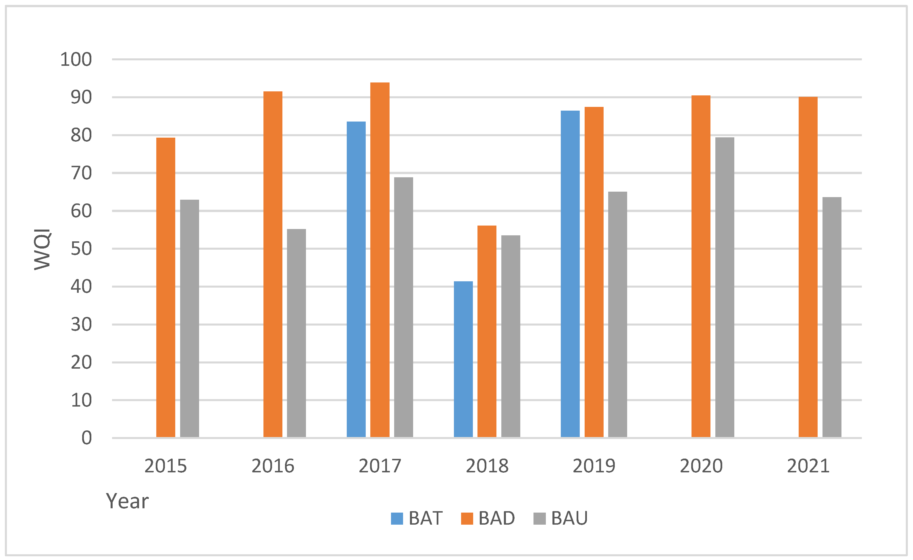
For the Batova River, the waters in the BAD point have the most favorable quality characteristics, and the waters in the estuary section BAU have the worst;
-
For the Dvoinitsa River, the river waters at the point DVD are defined as the cleanest, and the most polluted are those immediately before entering the Black Sea-the point DVD;
-
The quality condition in the river of Aheloy is most favorable at the AHA point, and the river waters at the AHD and AHU points have markedly deteriorated physicochemical characteristics that do not meet the criteria for “fair” quality condition laid down in Ordinance No. H-4 for the characterization of surface waters;
-
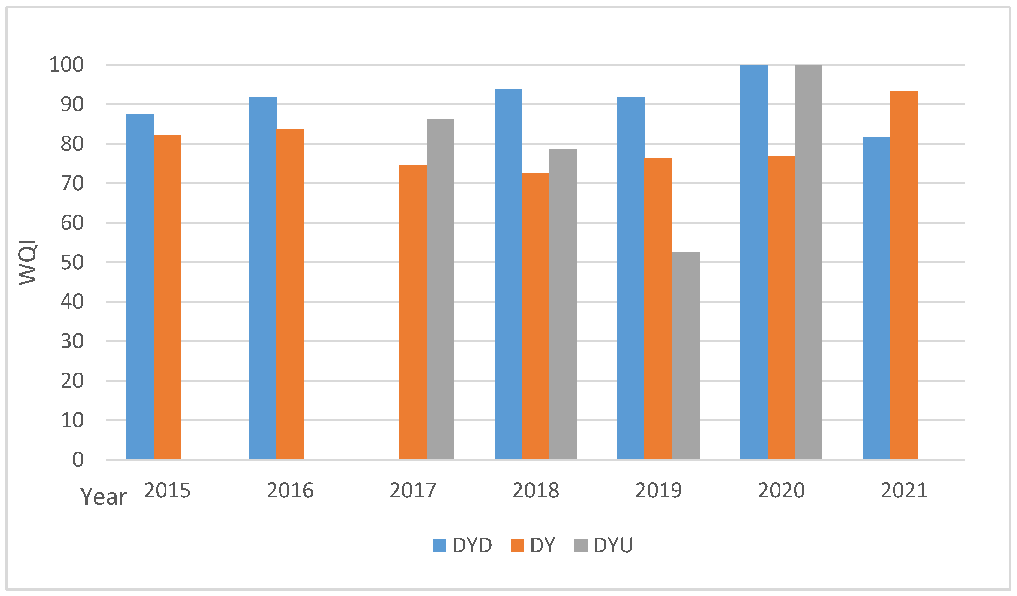
The best-quality waters in the Dyavolska River are the waters at the point DYD, and the most polluted is the river section at the point DYU;
-
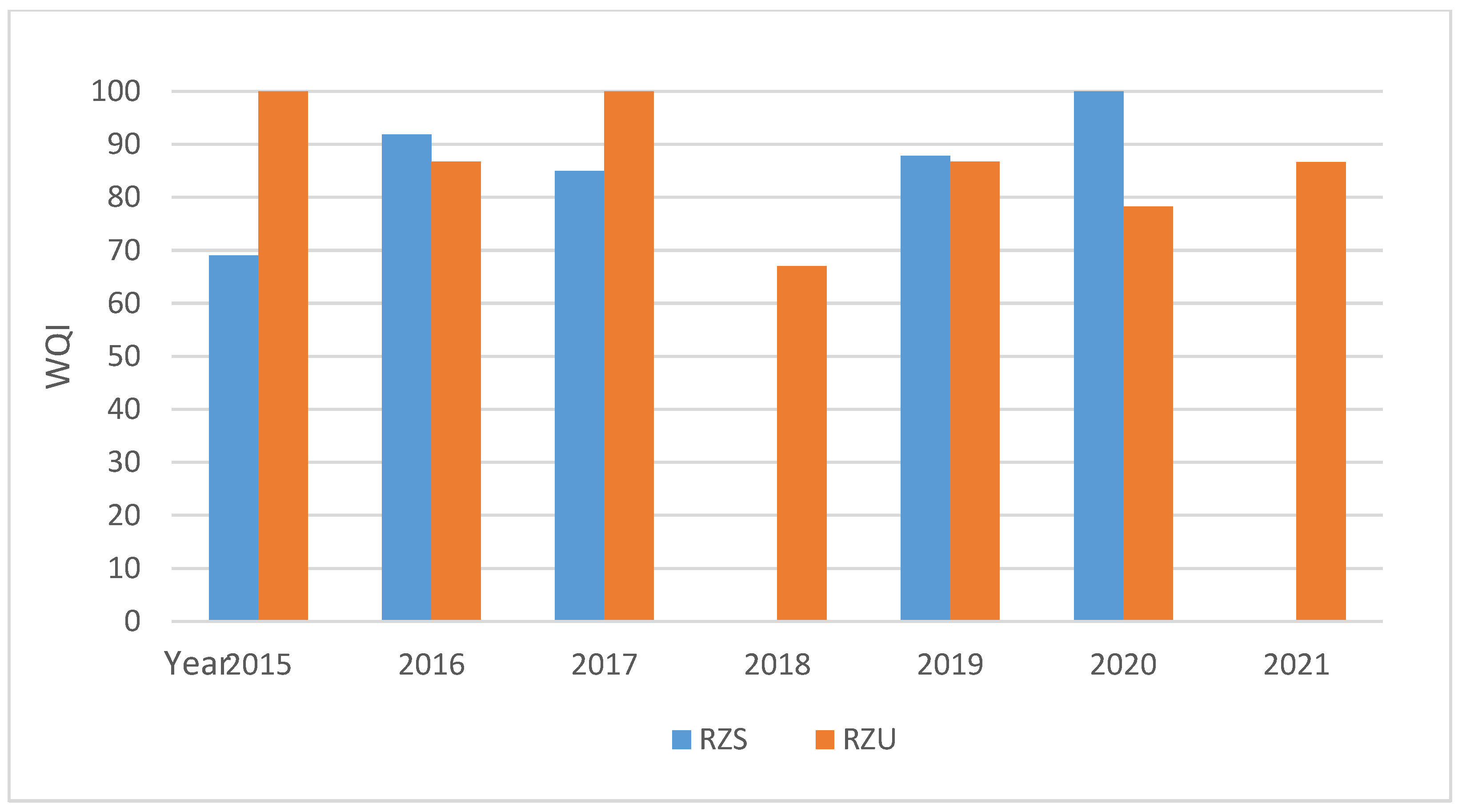
The surface waters of the Rezovska River in both research points-RZS and RZU—hold a satisfactory quality status according to the norms;
-
The quality of the river waters in the studied watersheds varies both in the individual years of the analysis period and also in the different points of the river systems, with no deterioration or improvement in their quality status;
-
Most often, in almost all studied points, the leading and constant exceedances are usually 10 times the norm for the indicators total phosphorus (P-Total), orthophosphates (P-PO4), nitrite nitrogen (N-NO2), and nitrogen (N-Total). The deviations from the norms for the other physicochemical indicators are not defined as so frequent.
The deviations from the normative requirements for these indicators leads to a conclusion that the main potential sources of pollution are the following:
  • Agricultural activities carried out in the watersheds of the studied river basins through the excessive or incorrect use and storage of organic and mineral fertilizers as well as waste water from the operation of, albeit small, livestock complexes and farms, mainly poultry farms and pig farms, located in the study area;
  • Discharge of untreated waste water from the sewers of populated areas and insufficiently treated domestic waste water from urban, resort, and industrial WWTPs;
  • Regulated and unregulated landfills, the seepage of wastewater from the septic tanks of the settlements into the aquifers of the river basins, as well as the lack of treatment plants and sewerage networks.
An important tool for achieving the main objectives of the Water Framework Directive on maintaining or improving the quality of water bodies is the development and implementation of a program of certain measures.
Taking into account the specificity of the anthropogenic load on the waters of the Batova, Dvoinitsa, Aheloy, Dyavolska, and Rezovska rivers as well as the nature of the polluting substances and the possible sources of pollution, some basic and effective measures are as follows:
  • Construction of new and reconstruction of existing WWTPs and the provision of biological wastewater treatment;
  • Control over the fulfillment of the conditions in the complex permits and, if necessary, revision of the conditions;
  • Implementation of good farming and agricultural practices;
  • Planting intermediate crops in cultivated areas and increasing diversity in crop rotations;
  • Closure and reclamation of municipal landfills;
  • Reducing the phosphorus load by introducing additional measures such as switching to phosphate-free detergents and optimizing the use of sewage sludge, as a result of which the application of artificial fertilizers in agriculture will be reduced.

4. Conclusions

The overview of the nexus concept in the tripartite relationship water–energy–food reveals the key role played by the water sector. It highlights the need to apply a multi-sector approach in the process of achieving synergies and mitigating trade-offs involving multiple interested parties—government agencies, the private sector, academia, and civil society.
As a result of the application of the CCME-WQI, the advantages of the used index were revealed, allowing us to obtain complex and differentiated assessments for different temporal and spatial summaries. The performed analysis and the obtained assessment of the quality of the river waters along the Bulgarian Black Sea coast serve as a basis for future studies in the same model area for the remaining two components in the energy and food relationship.
This research provides new knowledge about this concept in the country and provides regional water quality assessments. The authors of the present study strongly express the opinion that research on the quality of water should become an integral part of research on the water–energy–food relationship.

Author Contributions

Conceptualization, K.G., S.G. and A.K.; methodology, K.G.; software, and validation, S.G.; resources, K.G. and A.K.; data curation, A.K. and K.G.; writing—review and editing, K.G., S.G. and A.K.; visualization, K.G. and A.K.; funding acquisition, K.G. All authors have read and agreed to the published version of the manuscript.

Funding

This research was funded by Bulgarian National Scientific Fund Administrative contract № KП-06-KOCT-1/17.05.2022 (for the provision of national co-financing for the participation of Bulgarian collectives in approved actions under the European program for cooperation in the field of scientific research and technology COST—COST Action CA20138—NEXUSNET “NETWORK ON WATER-ENERGY-FOOD NEXUS FOR A LOW-CARBON ECONOMY IN EUROPE AND BEYOND”, with a theme Integrated NEXUS Approach and Connection Water Energy Food—Transfer of Knowledge, Practical Applications and Challenges”) of the Ministry of Education and Science, Bulgaria.

Data Availability Statement

The data presented in this study are available on request from the corresponding author.

Conflicts of Interest

The authors declare no conflicts of interest. The funders had no role in the design of the study; in the collection, analyses, or interpretation of data; in the writing of the manuscript; or in the decision to publish the results.

References

  1. Gartsiyanova, K. Surface Water Quality Conservation in Bulgaria, 1st ed.; Avangard Prima: Sofia, Bulgaria, 2022; p. 172. (In Bulgarian) [Google Scholar]
  2. Ioannou, A.; Laspidou, C. Cross-Mapping Important Interactions between Water-Energy-Food Nexus Indices and the SDGs. Sustainability 2023, 15, 8045. [Google Scholar] [CrossRef]
  3. Interim Overview of Significant Water Management Issues in the Black Sea River Basin Management District 2016–2021. Available online: https://www.bsbd.org/uk/RBM_mplans.html (accessed on 27 February 2024).
  4. Hristova, N. Hydrology of Bulgaria, 1st ed.; Tip Top Press: Sofia, Bulgaria, 2012; p. 830. (In Bulgarian) [Google Scholar]
  5. River Basin Management Plan of the Black Sea Basin Directorate for the Period 2016–2021. Available online: https://www.bsbd.org/bg/index_bg_5493788.html (accessed on 9 January 2024). (In Bulgarian).
  6. Ordinance N-4/2012 for Characterisation of Surface Waters. D V 2013, 22, 9–46. Available online: http://eea.government.bg/bg/legislation/water/Naredba13.pdf (accessed on 9 January 2024). (In Bulgarian)
  7. European Parliament, Council of the European Union. Directive 2000/60/EC of the European Parliament and of the Council establishing a framework for Community action in the field of water policy. Off. J. Eur. Union 2000, 327, 1–73. [Google Scholar]
  8. Vatseva, R. Mapping urban land use and land cover change in the Black Sea coastal zone in Bulgaria for the period 1977–2011 using Remote Sensing and GIS. Comptes Rendus De L’Academie Bulg. Des Sci. 2015, 68, 903–908. [Google Scholar]
  9. Canadian Council of Ministers of the Environment (CCME). Canadian Water Quality Guidelines for the Protection of Aquatic Life. Canadian Water Quality Index 1.0 Technical Report, Canadian Council of Ministers of the Environment, Excerpt from Publication No 1299. 2001. Available online: https://unstats.un.org/unsd/envaccounting/ceea/archive/Water/CCME_Canada.PDF (accessed on 9 January 2024).
  10. Liu, J.; Yangb, H.; Cudennec, C.; Gain, A.; Hoff, H.; Lawford, R.; Qi, J.; Strasser, L.D.; Yilliak, P.; Zheng, C. Challenges in operationalizing the water-energy-food nexus. Hydrol. Sci. J. 2017, 62, 1714–1720. [Google Scholar] [CrossRef]
  11. Mc Grane, S.; Acuto, M.; Artioli, F.; Chen, P.; Comber, R.; Cottee, G.; Farr-Wharton, G.; Green, N.; Helfgott, A.; Larcom, S.; et al. Scaling the nexus: Towards integrated frameworks for analysing water, energy and food. Geogr. J. 2019, 185, 419–431. [Google Scholar] [CrossRef]
  12. United Nations. Transforming Our World: The 2030 Agenda for Sustainable Development; A/RES/70/1; United Nations: New York, NY, USA, 2015; Available online: https://sdgs.un.org/2030agenda (accessed on 9 January 2024).
  13. Huntington, H.; Schmidt, J.; Loring, P.; Whitney, E.; Aggarwal, S.; Byrd, A.; Dev, S.; Dotson, A.; Huang, D.; Johnson, B.; et al. Applying the food-energy-water nexus concept at the local scale. Nat. Sustain. 2021, 4, 672–679. [Google Scholar] [CrossRef]
  14. Sargentis, G.-F.; Lagaros, N.; Cascella, G.; Koutsoyiannis, D. Threats in Water-Energy-Food-Land Nexus by the 2022 Military and Economic Conflict. Land 2022, 11, 1569. [Google Scholar] [CrossRef]
  15. Liu, D.; Guo, S.; Chen, X.; Shao, Q.; Ran, Q.; Song, X.; Wang, Z. A macro-evolutionary multi-objective immune algorithm with application to optimal allocation of water resources in Dongjiang River basins, South China. Stoch. Environ. Res. Risk Assess. 2012, 26, 491–507. [Google Scholar] [CrossRef]
  16. Varis, O.; Keskinen, M. Discussion of “Challenges in operationalizing the water-energy-food nexus”. Hydrol. Sci. J. 2018, 63, 1863–1865. [Google Scholar] [CrossRef]
  17. Prüss-Ustün, A.; Wolf, J.; Bartram, J.; Clasen, T.; Cumming, O.; Freeman, M.; Gordon, B.; Hunter, P.; Medlicott, K.; Johnston, R. Burden of disease from inadequate water, sanitation and hygiene for selected adverse health outcomes: An updated analysis with a focus on low- and middle-income countries. Int. J. Hyg. Environ. Health 2019, 222, 765–777. [Google Scholar] [CrossRef]
  18. Laspidou, K.; Mellios, N.; Spyropoulou, A.; Kofinas, D.; Papadopoulou, M. Systems thinking on the resource nexus: Modeling and visualisation tools to identify critical interlinkages for resilient and sustainable societies and institutions. Sci. Total Environ. 2020, 717, 137264. [Google Scholar] [CrossRef] [PubMed]
  19. Van Emmerik, H.; Li, Z.; Sivapalan, M.; Pande, S.; Kandasamy, J.; Savenije, H.; Chanan, A.; Vigneswaran, S. Socio-hydrologic modeling to understand and mediate the competition for water between agriculture development and environmental health: Murrumbidgee River basin, Australia. Hydrol. Earth Syst. Sci. 2014, 18, 4239–4259. [Google Scholar] [CrossRef]
  20. Scanlon, B.; Ruddell, B.; Reed, P.; Hook, R.; Zheng, C.; Tidwell, V.; Siebert, S. The food-energy-water nexus: Transforming science for society. Water Resour. Res. 2017, 53, 3550–3556. [Google Scholar] [CrossRef]
  21. Cudenneca, C.; Liub, J.; Qid, J.; Yange, H.; Zhengb, C.; Gaing, A.; Lawfordh, R.; de Strasseri, L.; Yillia, P. Epistemological dimensions of the water-energy-food nexus approach: Reply to discussions of “Challenges in operationalizing the water-energy-food nexus”. Hydrol. Sci. J. 2018, 63, 1868–1871. [Google Scholar] [CrossRef]
  22. Keskinen, M.; Joseph, H.; Guillaume, A.; Kattelus, M.; Porkka, M.; Timo, A.; Varis, R. The water-energy-food nexus and the transboundary context: Insights from large Asian rivers. Water 2016, 8, 193. [Google Scholar] [CrossRef]
  23. UNEP. A Snapshot of the World’s Water Quality: Towards a Global Assessment; United Nations Environment Programme: Nairobi, Kenya, 2016; Available online: https://wedocs.unep.org/handle/20.500.11822/19524 (accessed on 9 January 2024).
  24. de Strasser, L.; Lipponen, A.; Howells, M.; Stec, S.; Bréthaut, C. A methodology to assess the water energy food ecosystems nexus in transboundary river basins. Water 2016, 8, 59. [Google Scholar] [CrossRef]
  25. United Nations Economic Commission for Europe (UNECE). Methodology for Assessing the Water-Food-Energy-Ecosystems Nexus in Transboundary Basins and Experiences from Its Application: Synthesis; United Nations Publication: New York, NY, USA; Geneva, Switzerland, 2018; pp. 1–76. Available online: https://unece.org/sites/default/files/2022-10/ECE_MP.WAT_55_ENG.pdf (accessed on 9 January 2024).
  26. Gartsiyanova, K.; Genchev, S.; Kitev, A. Transboundary River water quality as a core indicator for sustainable environmental development in Europe: A case study between republics of Bulgaria and Serbia. Casp. J. Environ. Sci. 2023, 21, 291–300. [Google Scholar]
  27. Gartsiyanova, K.; Varbanov, M.; Kitev, A.; Genchev, S.; Tcherkezova, E. Water Conservation and River Water Quality of the Bulgarian Black Sea Tributaries. Int. J. Conserv. Sci. 2022, 13, 981–990. [Google Scholar]
  28. Damyanova, S.; Varadinova, E. Ecological Status Assessment of Batova River (Bulgaria). Ecol. Balk. 2018, 10, 149–154. [Google Scholar]
  29. Simeonova, A.; Bekyarova, J.; Chuturkova, R. Investigations of the river Kamchiya impact over the Varna Black Sea coast status. Ecol. Eng. Environ. Prot. 2011, 1, 25–30. [Google Scholar]
  30. Gartsiyanova, K. Nitrate pollution of the river water in the Black Sea drainage area. Probl. Geogr. 2016, 1–2, 47–57. [Google Scholar]
  31. Trukhchev, D.; Shtereva, G.; Krastev, A.; Slabakova, V. Oceanographic research on the quality of the coastal waters affected by runoff from the river Dvoynitsa. Izvestia Union Sci.–Varna “Mar. Sci.” Ser. 2016, 42–49. [Google Scholar]
  32. Dineva, S. Water Discharges into the Bulgarian Black Sea. In Proceedings of the International Symposium on Outfall Systems, Mar del Plata, Argentina, 15–18 May 2011. [Google Scholar]
  33. Doychev, D. Longitudinal recovery gradient of macroinvertebrates during different hydrological scenarios in a downstream river reach. J. Limnol. 2023, 82, 71–83. [Google Scholar] [CrossRef]
  34. Manev, I.; Kirov, V.; Neshovska, H. Heavy metals accumulation in Black Sea ecosystems: Seawater, sediment, algae, benthic organisms. Tradit. Mod. Vet. Med. 2020, 5, 88–99. [Google Scholar]
Figure 1. Map of the study area.
Hydrology 11 00036 g001
Figure 2. Change in WQI values calculated for Batova River in the period 2015–2021.
Hydrology 11 00036 g002
Figure 3. Change in WQI values calculated for Dvoinitsa River in the period 2015–2021.
Hydrology 11 00036 g003
Figure 4. Change in WQI values calculated for Aheloy River in the period 2015–2021.
Hydrology 11 00036 g004
Figure 5. Change in WQI values calculated for Dyavolska River in the period 2015–2021.
Hydrology 11 00036 g005
Figure 6. Change in WQI values calculated for Rezovska River in the period 2015–2021.
Hydrology 11 00036 g006
Table 1. Information for the selected monitoring points.
Monitoring PointsCode of the Sampling StationsCoordinatesType of Water BodyCode on the Map
Batova River—before Batovo villageBG2DO01835MS26927.9466
43.4038
R11BAT
Batova River—Dolishte villageBG2DO08399MS20127.8975
43.3401
R11BAD
Batova River—mouthBG2DO00831MS00128.0564
43.3578
R11BAU
Dvoinitsa River—before Popovich villageBG2SE400R006RP0827.7763
42.8397
R11DVP
Dvoinitsa River—after Dulino villageBG2SE04519MS23027.7406
42.8486
R4DVD
Dvoinitsa River—before flowing into the Black SeaBG2SE00041MS00327.8768
42.8264
R16DVU
Aheloy River—before the Aheloy DamBG2SE00859MS23627.4428
42.7189
R4AHD
Aheloy River—before Aheloy villageBG2SE00081MS23727.6376
42.6547
R11AHA
Aheloy River—Aheloy camp BG2SE81MS00827.6405
42.6341
R16AHU
Dyavolska River—before the Yasna Polyana DamBG2IU49159MS25227.5524
42.2419
R4DYD
Dyavolska River—5 km before PrimorskoBG2IU411MS00127.6649
42.2689
R11DY
Dyavolska River—before its mouth, Primorsko townBG2IU07411MS40827.75058
42.26008
R16DYU
Rezovska River—Slivarovo villageBG2RE855MS00127.6595
41.9606
R4RZS
Rezovska River—mouthBG2RE855MS00228.0246
41.805
R16RZU
Table 2. Physicochemical elements for “good” quality (category “River”) according to Ordinance N-4 on surface water characterization (2012).
Types of RiversDissolved Oxygen, mg/LpHElectrical Conductivity
μS/cm
N-NH4,
mg/L
N-NO3,
mg/L
N-NO2,
mg/L
Total Nitrogen mg/LP-Ortho-
Po4, Mg/L
P-Total Phosphorus
mg/L
Bod5,
Mg/L
R48.00–6.006.5–8.5650–7500.04–0.20.4–1.40.01–0.030.5–1.50.02–0.040.025–0.0751.2–3
R11
R16
6.00–5.006.5–8.5650–7500.2–0.30.9–2.00.03–0.061.0–2.50.07–0.150.15–0.32–5
Disclaimer/Publisher’s Note: The statements, opinions and data contained in all publications are solely those of the individual author(s) and contributor(s) and not of MDPI and/or the editor(s). MDPI and/or the editor(s) disclaim responsibility for any injury to people or property resulting from any ideas, methods, instructions or products referred to in the content.

