
A Water Surface Contaminants Monitoring Method Based on Airborne Depth Reasoning

 ,
,
Abstract
:1. Introduction
2. Materials and Methods
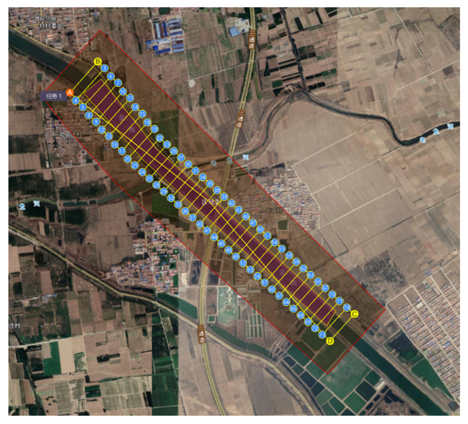
2.1. Study Area and UAV Trajectory Planning
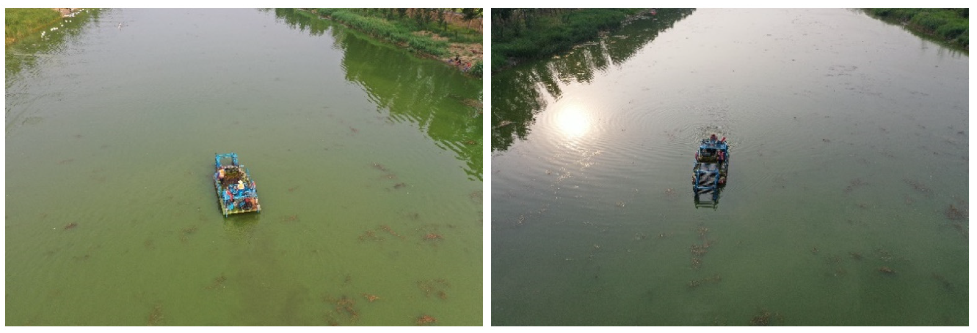
2.2. Data Acquisition
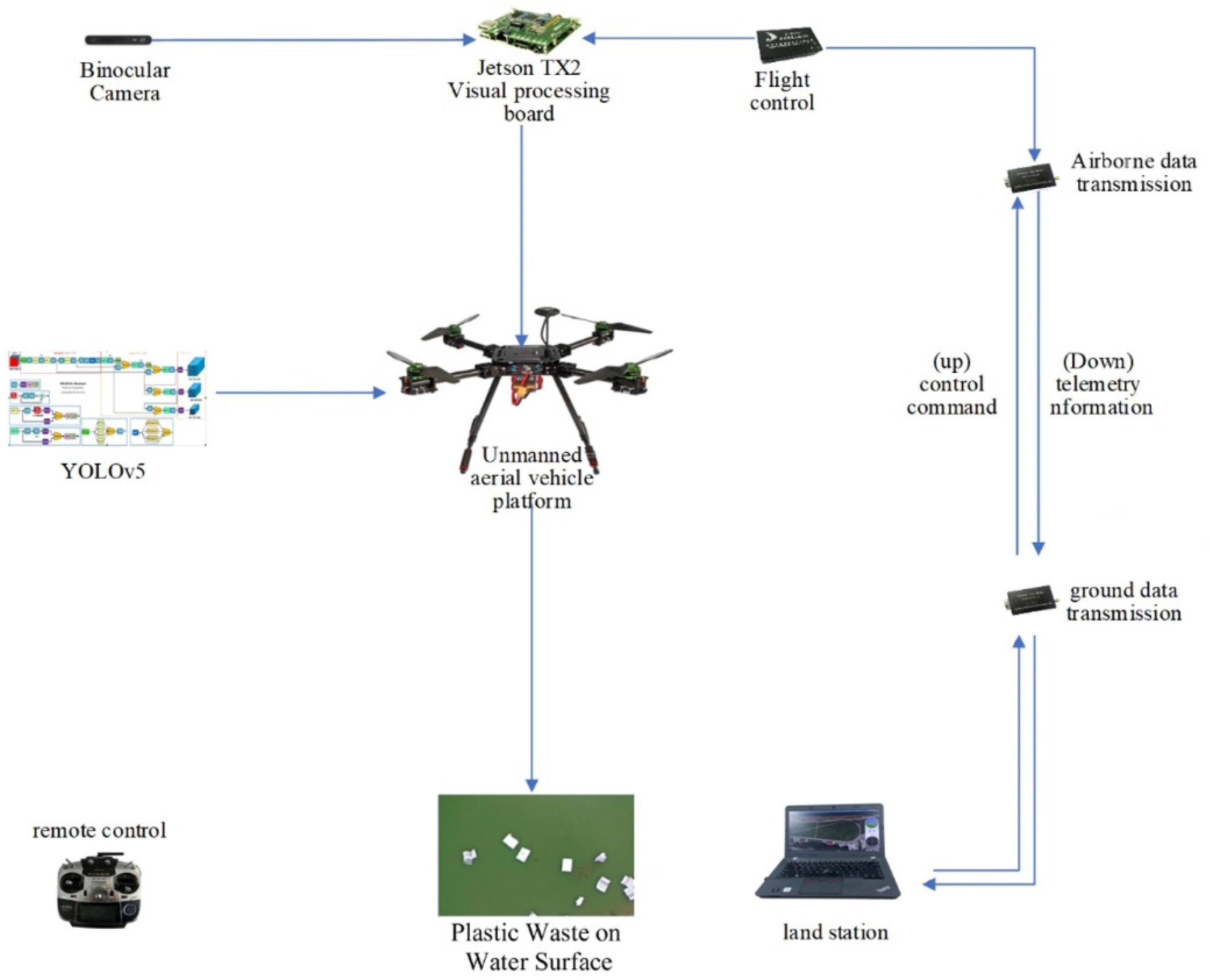
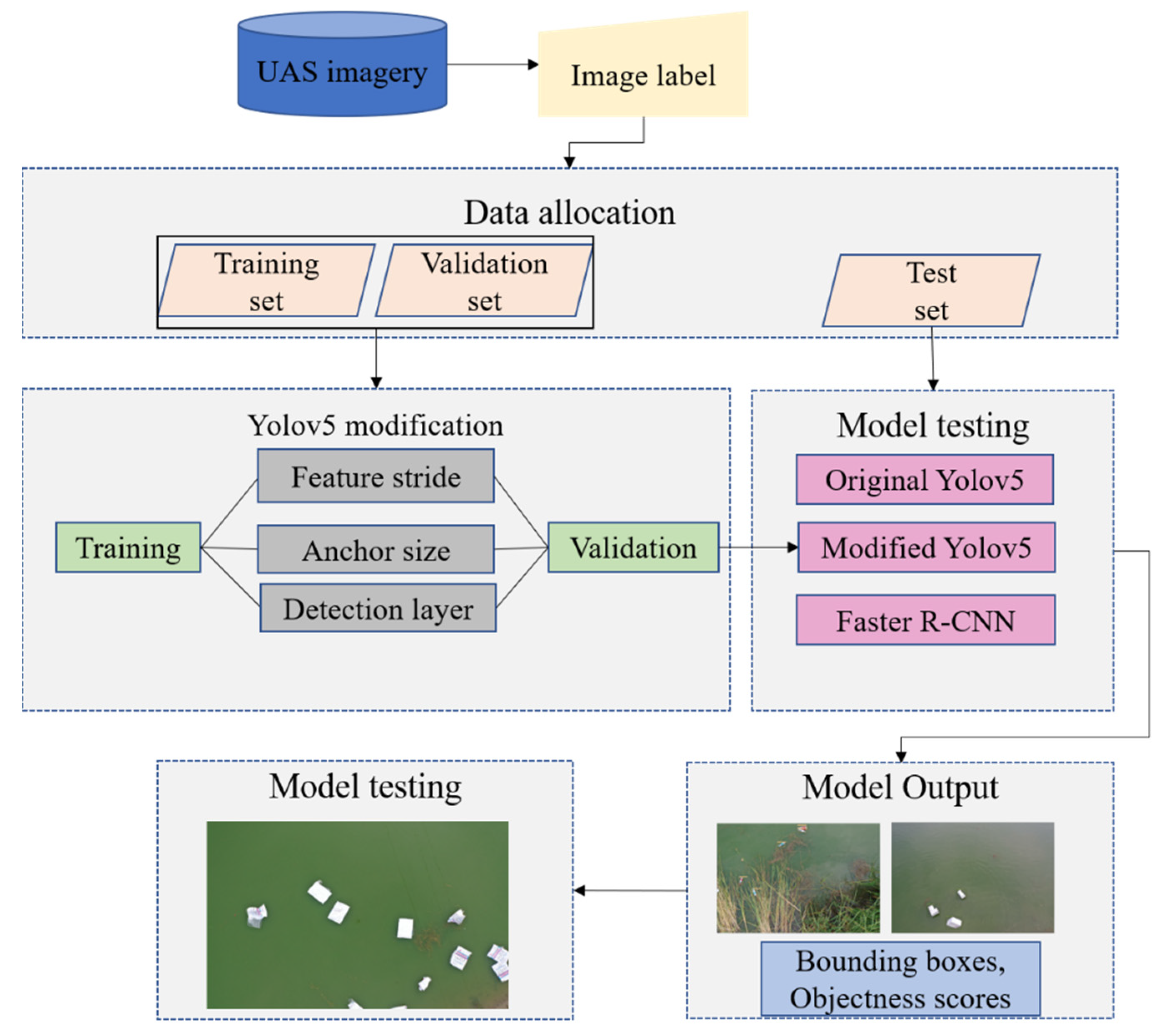
2.3. Overall Research Framework
2.4. Deep Network
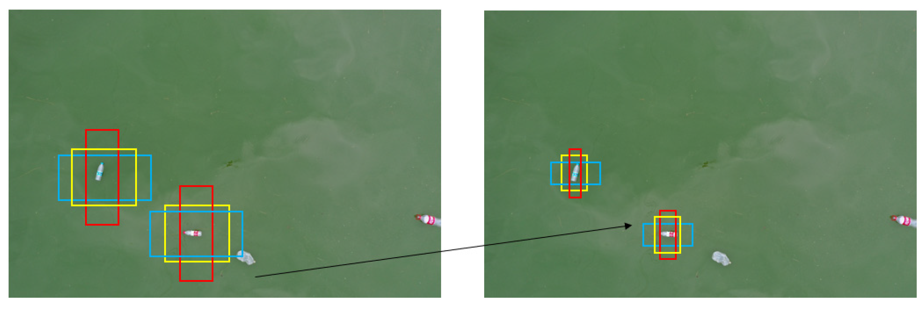
- Modifying anchor structure
- 2.
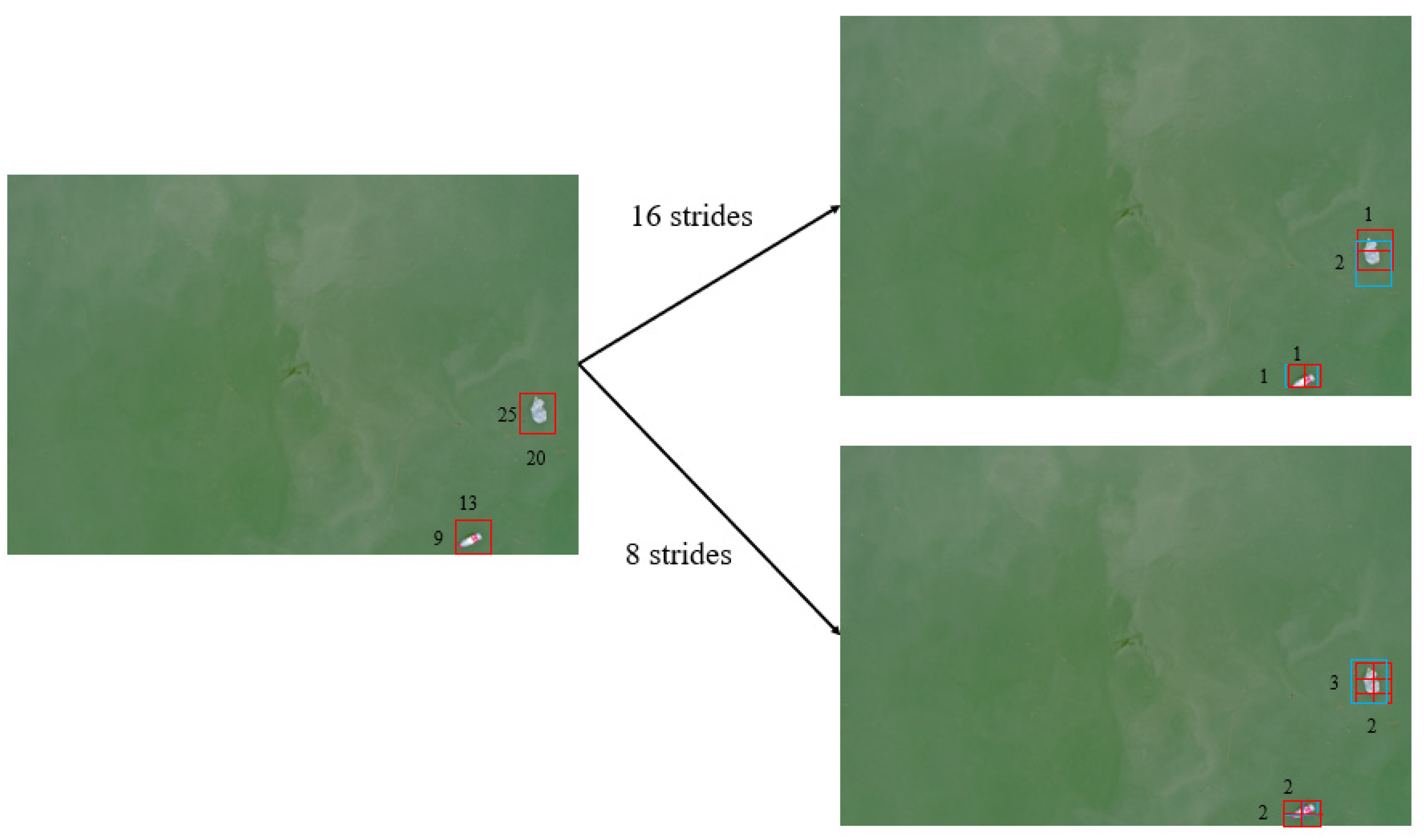
- Modify step size
- 3.
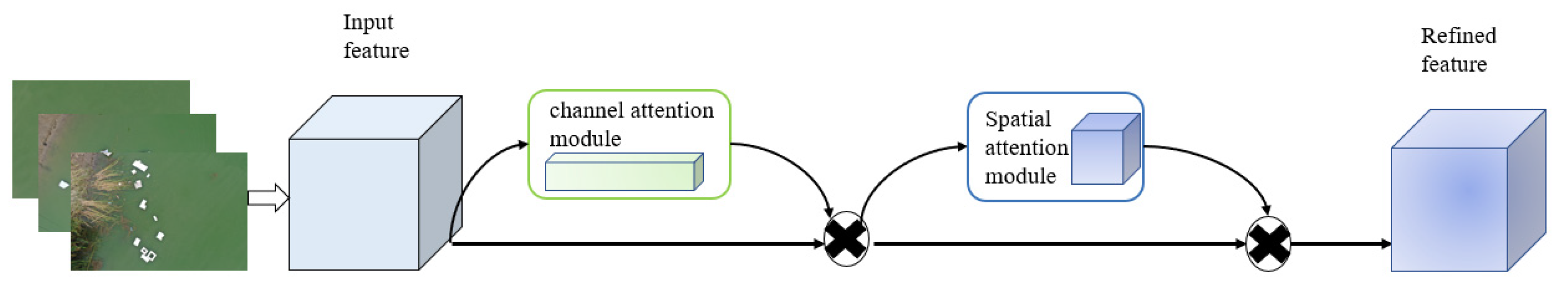
- Mechanism of increasing attention
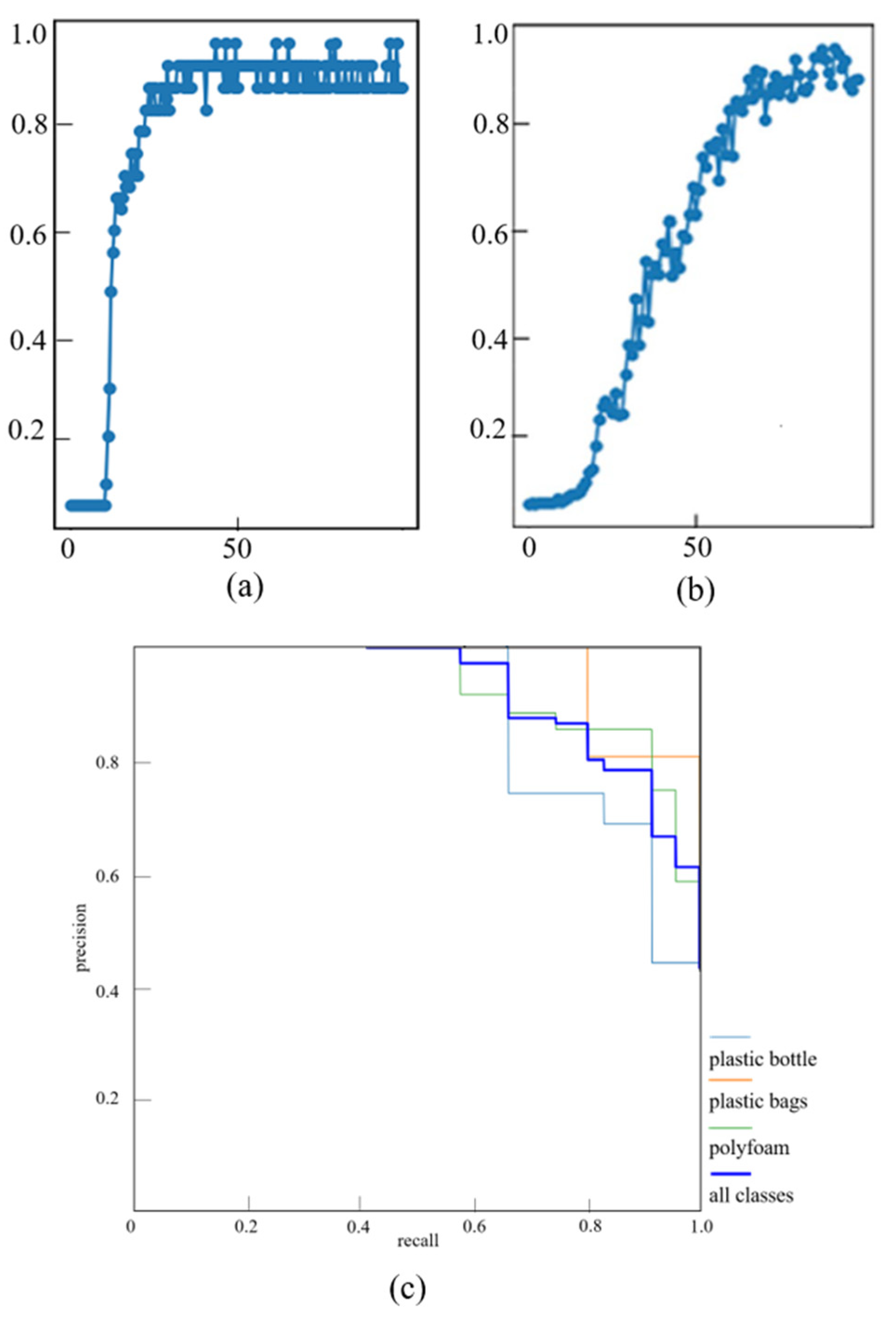
3. Results
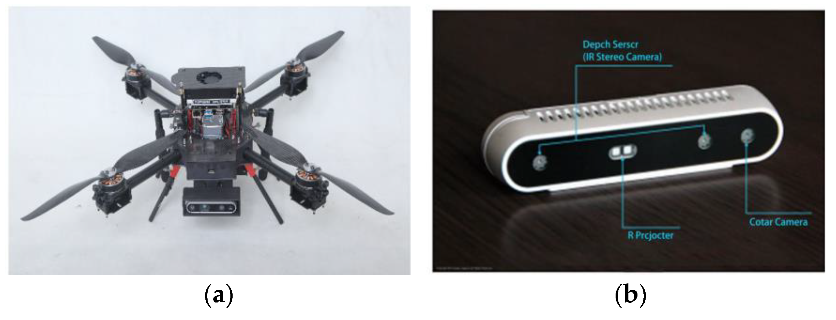
3.1. Experimental Platform
3.2. Model Training Results
- a.
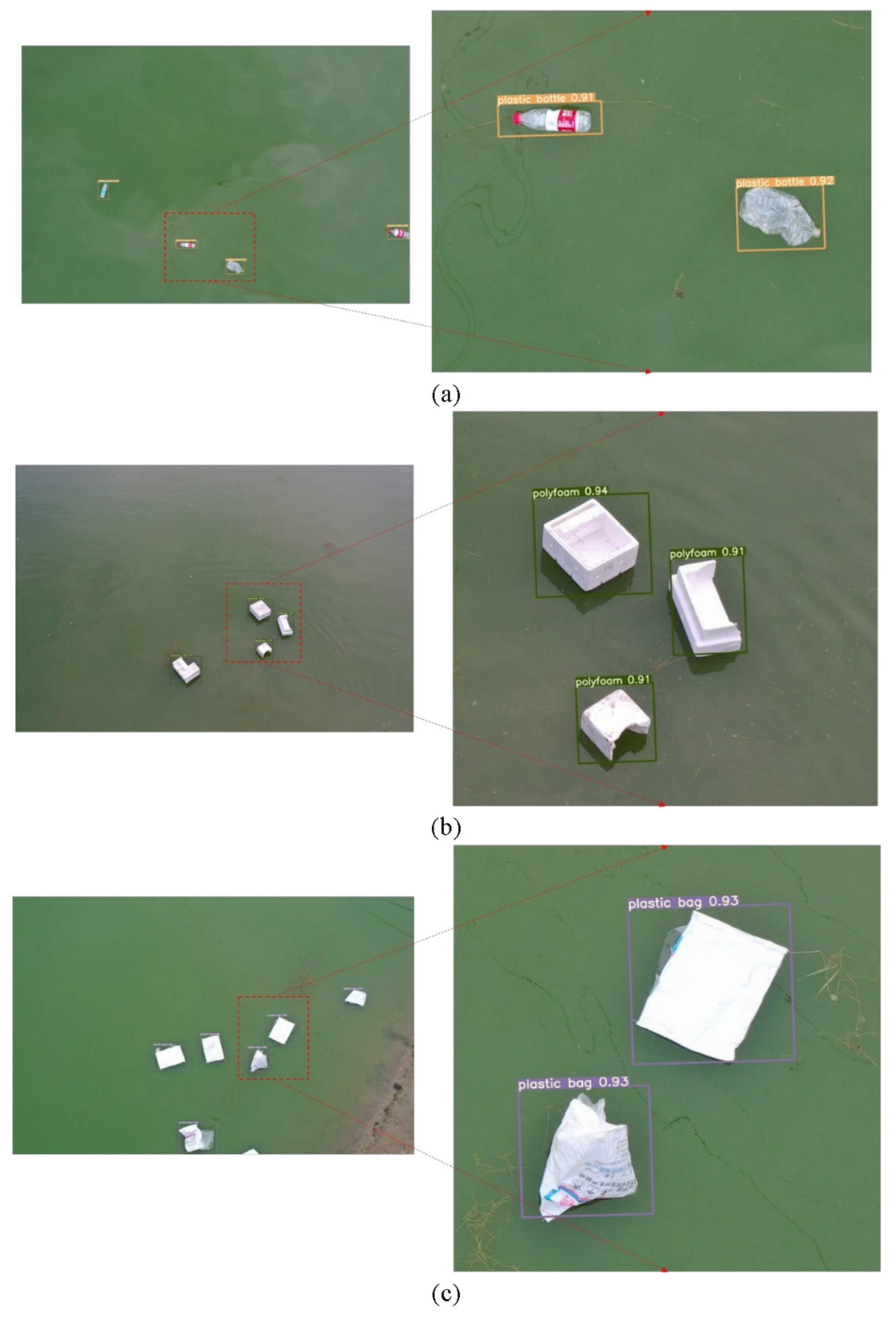
- Performance Evaluation
- Recognition results
- 2.
- Accuracy comparison
4. Discussion
5. Conclusions
Author Contributions
Funding
Institutional Review Board Statement
Informed Consent Statement
Data Availability Statement
Acknowledgments
Conflicts of Interest
References
- Lebreton, L.; van der Zwet, J.; Damsteeg, J.W.; Slat, B.; Andrady, A.; Reisser, J. River plastic emissions to the world’s oceans. Nat. Commun. 2017, 8, 1–10. [Google Scholar] [CrossRef]
- Gordana, J.; Govedarica, M.; Alvarez-Taboada, F. A Deep Learning Model for Automatic Plastic Mapping Using Unmanned Aerial Vehicle (UAV) Data. Remote Sens. 2020, 12, 1515. [Google Scholar]
- Haward, M. Plastic pollution of the world’s seas and oceans as a contemporary challenge in ocean governance. Nat. Commun. 2018, 9, 667. [Google Scholar] [CrossRef] [PubMed] [Green Version]
- Da Costa, J.P.; Mouneyrac, C.; Costa, M.; Duarte, A.C.; Rocha-Santos, T. The Role of Legislation, Regulatory Initiatives and Guidelines on the Control of Plastic Pollution. Front. Environ. Sci. 2020, 8, 104. [Google Scholar] [CrossRef]
- Hardesty, B.D.; Lawson, T.J.; van der Velde, T.; Lansdell, M.; Wilcox, C. Estimating quantities and sources of water surface debris at a continental scale. Front. Ecol. Environ. 2016, 15, 18–25. [Google Scholar] [CrossRef]
- Burgess, H.K.; Herring, C.E.; Lippiatt, S.; Lowe, S.; Uhrin, A.V. NOAA Marine Debris Monitoring and Assessment Project Shoreline Survey Guide; NOAA Technical Memorandum NOS OR&R 56; NOAA: Washington, DC, USA, 2021; 20p. [Google Scholar] [CrossRef]
- Cheshire, A.C.; Adler, E.; Barbière, J.; Cohen, Y.; Evans, S.; Jarayabhand, S.; Jeftic, L.; Jung, R.T.; Kinsey, S.; Kusui, E.T.; et al. UNEP/IOC Guidelines on Survey and Monitoring of Water Surface Litter. UNEP Regional Seas Reports and Studies. No. 186; UNEP: Nairobi, Kenya, 2009; p. 120. [Google Scholar]
- Mecozzi, M.; Pietroletti, M.; Monakhova, Y.B. FTIR spectroscopy supported by statistical techniques for the structural characterization of plastic debris in the marine environment: Application to monitoring studies. Mar. Pollut. Bull. 2016, 106, 155–161. [Google Scholar] [CrossRef]
- Topouzelis, K.; Papakonstantinou, A.; Garaba, S.P. Detection of floating plastics from satellite and unmanned aerial systems (Plastic Litter Project 2018). Int. J. Appl. Earth Obs. Geoinf. 2019, 79, 175–183. [Google Scholar] [CrossRef]
- Kyriacos, T.; Papoutsa, C.; Michaelides, S.; Hadjimitsis, D. Investigating Detection of Floating Plastic Litter from Space Using Sentinel-2 Imagery. Remote Sens. 2020, 12, 2648. [Google Scholar]
- Garaba, S.P.; Aitken, J.; Slat, B.; Dierssen, H.M.; Lebreton, L.; Zielinski, O.; Reisser, J. Sensing Ocean Plastics with an Airborne Hyperspectral Shortwave Infrared Imager. Environ. Sci. Technol. 2018, 52, 11699–11707. [Google Scholar] [CrossRef]
- Gray, P.C.; Fleishman, A.B.; Klein, D.J.; McKown, M.W.; Bezy, V.S.; Lohmann, K.J.; Johnston, D.W. A Convolutional Neural Network for Detecting Sea Turtles in Drone Imagery. Methods Ecol. Evol. 2019, 10, 345–355. [Google Scholar] [CrossRef]
- Hong, S.-J.; Han, Y.; Kim, S.-Y.; Lee, A.-Y.; Kim, G. Application of Deep-Learning Methods to Bird Detection Using Unmanned Aerial Vehicle Imagery. Sensors 2019, 19, 1651. [Google Scholar] [CrossRef] [Green Version]
- Gonçalves, G.; Andriolo, U.; Pinto, L.; Bessa, F. Mapping marine litter using UAS on a beach-dune system: A multidisciplinary approach. Sci. Total Environ. 2020, 706, 135742. [Google Scholar] [CrossRef] [PubMed]
- Deidun, A.; Gauci, A.; Lagorio, S.; Galgani, F. Optimising beached litter monitoring protocols through aerial imagery. Mar. Pollut. Bull. 2018, 131, 212–217. [Google Scholar] [CrossRef]
- Merlino, S.; Paterni, M.; Berton, A.; Massetti, L. Unmanned aerial vehicles for debris survey in coastal areas: Long-term monitoring programme to study spatial and temporal accumulation of the dynamics of beached marine litter. Remote Sens. 2020, 12, 1260. [Google Scholar] [CrossRef] [Green Version]
- Simonyan, K.; Zisserman, A. Very deep convolutional networks for large-scale image recognition. arXiv 2014, arXiv:1409.1556. [Google Scholar]
- Long, J.; Shelhamer, E.; Darrell, T. Fully convolutional networks for semantic segmentation. In Proceedings of the IEEE Conference on Computer Vision and Pattern Recognition, Boston, MA, USA, 8–10 June 2015; pp. 3431–3440. [Google Scholar]
- Ren, S.; He, K.; Girshick, R.; Sun, J. Faster R-CNN: Towards Real-Time Object Detection with Region Proposal Networks. IEEE Trans. Pattern Anal. Mach. Intell. 2017, 39, 1137–1149. [Google Scholar] [CrossRef] [PubMed] [Green Version]
- Redmon, J.; Divvala, S.; Girshick, R.; Farhadi, A. You only look once: Unified, real-time object detection. In Proceedings of the IEEE Conference on Computer Vision and Pattern Recognition, Las Vegas, NV, USA, 27 June–1 July 2016; pp. 779–788. [Google Scholar]
- Ronneberger, O.; Fischer, P.; Brox, T. U-net: Convolutional networks for biomedical image segmentation. In International Conference on Medical Image Computing and Computer-Assisted Intervention; Springer: Cham, Switzerland, 2015; pp. 234–241. [Google Scholar]
- Kyriaki, K.; Ioannis, K.A.; Constantinos, H. Identifying floating plastic water surface debris using a deep learning approach. Environ. Sci. Pollut. Res. 2019, 26, 17091–17099. [Google Scholar]
- Junichiro, W.; Yang, S.; Naoto, M. Underwater and airborne monitoring of water surface ecosystems and debris. J. Appl. Remote Sens. 2019, 13, 044509. [Google Scholar]
- Kang, Z.; Ling, H.; Zhu, T.; Luo, H. Coverage Flight Path Planning for Multi-rotor UAV in Convex Polygon Area. In Proceedings of the 2019 Chinese Control And Decision Conference (CCDC), Nanchang, China, 3–5 June 2019. [Google Scholar]
- Zhang, Z.; Njilla, L.L.; Yu, S.; Yuan, J. Edge-Assisted Learning for Real-Time UAV Imagery via Predictive Offloading. In Proceedings of the 2019 IEEE Global Communications Conference (GLOBECOM), Waikoloa, HI, USA, 9–13 December 2019. [Google Scholar]
- Redmon, J.; Farhadi, A. YOLOv3: An Incremental Improvement. arXiv 2018, arXiv:1804.02767. [Google Scholar]
- Bochkovskiy, A.; Wang, C.Y.; Liao, H.Y.M. YOLOv4: Optimal Speed and Accuracy of Object Detection. arXiv 2020, arXiv:2004.10934. [Google Scholar]
- Castro-Jiménez, J.; González-Fernández, D.; Fornier, M.; Schmidt, N.; Sempéré, R. Macro-litter in surface waters from the Rhone River: Plastic pollution and loading to the NW Mediterranean Sea. Mar. Pollut. Bull. 2019, 146, 60–66. [Google Scholar] [CrossRef] [PubMed]
- Everingham, M.; Van Gool, L.; Williams, C.K.I.; Winn, J.; Zisserman, A. The Pascal Visual Object Classes (VOC) Challenge. Int. J. Comput. Vis. 2010, 88, 303–338. [Google Scholar] [CrossRef] [Green Version]


| Network | FPS | P | R | mAP | Size of Model | |||
|---|---|---|---|---|---|---|---|---|
| Faster-CNN | 10.24 | 0.88 | 0.87 | 0.82 | 0.88 | 0.86 | 0.85 | 345 MB |
| SSD | 26.24 | 0.69 | 0.65 | 0.62 | 0.68 | 0.65 | 0.65 | 35.6 MB |
| Yolov3 | 35.62 | 0.73 | 0.76 | 0.71 | 0.73 | 0.75 | 0.73 | 236 MB |
| Yolov5 | 46.37 | 0.80 | 0.82 | 0.81 | 0.82 | 0.80 | 0.81 | 14.5 MB |
| Modified Yolov5 | 43.63 | 0.86 | 0.89 | 0.80 | 0.89 | 0.87 | 0.86 | 15.2 MB |
Publisher’s Note: MDPI stays neutral with regard to jurisdictional claims in published maps and institutional affiliations. |
© 2022 by the authors. Licensee MDPI, Basel, Switzerland. This article is an open access article distributed under the terms and conditions of the Creative Commons Attribution (CC BY) license (https://creativecommons.org/licenses/by/4.0/).
Share and Cite
Luo, W.; Han, W.; Fu, P.; Wang, H.; Zhao, Y.; Liu, K.; Liu, Y.; Zhao, Z.; Zhu, M.; Xu, R.; et al. A Water Surface Contaminants Monitoring Method Based on Airborne Depth Reasoning. Processes 2022, 10, 131. https://doi.org/10.3390/pr10010131
Luo W, Han W, Fu P, Wang H, Zhao Y, Liu K, Liu Y, Zhao Z, Zhu M, Xu R, et al. A Water Surface Contaminants Monitoring Method Based on Airborne Depth Reasoning. Processes. 2022; 10(1):131. https://doi.org/10.3390/pr10010131
Chicago/Turabian StyleLuo, Wei, Wenlong Han, Ping Fu, Huijuan Wang, Yunfeng Zhao, Ke Liu, Yuyan Liu, Zihui Zhao, Mengxu Zhu, Ruopeng Xu, and et al. 2022. "A Water Surface Contaminants Monitoring Method Based on Airborne Depth Reasoning" Processes 10, no. 1: 131. https://doi.org/10.3390/pr10010131