1. Introduction
Throughout the Earth’s history, the various processes that have shaped its surface have left behind numerous geological formations that many have admired and tried to understand. The differentiation between processes and their subsequent abiotic evidence on the Earth’s surface is what encompasses geodiversity, the natural range of geological (rocks, minerals, fossils), geomorphological (landform, processes) and soil features [
1]. Geodiversity is closely intertwined with cultural heritage. The relationship between the two stems from the fact that human societies have developed and interacted with their natural environments throughout history. Additionally, geomorphosites, one of the principal components of geodiversity, play a crucial role in enhancing our comprehension of the Earth’s past [
2] as they qualify as a component of a territory’s cultural heritage [
3]. A geomorphosite is defined as a landform that possesses historical, cultural, aesthetic and socioeconomic significance [
4]. The correlation between the cultural aspects of a region and its geomorphological context promotes the acknowledgment of geoheritage [
5,
6], mainly because the natural variation of geology, landscapes and landforms provides the physical backdrop required for cultural activities, therefore shaping the landscapes where communities have settled, built their infrastructure and created their culture throughout human history.
A comprehensive understanding of the geological framework of the area and its significance is important not only for scientists but also for the public. Often, scientific information related to geology, such as biodiversity, cultural and archaeological studies, is conducted and disseminated in a disjointed manner. This can lead to a lack of holistic understanding of the area, and important information and links between different types of studies can be overlooked. For example, studies on the geology of an area may not consider the impact of geological activity on its biodiversity, or cultural and archaeological studies may not consider the geological history of the area. Collaboration and integration of results between researchers and stakeholders is necessary to create a comprehensive understanding of the study area that will lead to better conservation and management strategies. This can also increase public awareness of the values and importance of the area. Therefore, the development of novel and efficient methods to communicate scientific research results to the public and to disseminate information about geological heritage, geological hazards and geotourism is crucial [
7,
8]. Recent studies have focused on developing methods to promote the geological aspects of natural and cultural heritage by emphasizing the importance of integrating geoheritage into conservation, education and tourism practices [
9]. The development of geosites with unique geological features that provide opportunities for educational and recreational activities as well as geotourism has been explored as a method to promote geoheritage [
10,
11]. By highlighting the geological value of a site, geotourism can enhance visitor experiences and foster a deeper understanding and appreciation of the Earth’s history. In recent decades, geotourism has emerged as a dynamic concept that has experienced significant growth [
12] and promoted economic growth in parallel with promoting natural and cultural heritage [
13]. Geotourism is characterized as a type of tourism that emphasizes the natural environment and geological aspects of an area. According to [
14,
15], geotourism is defined as the promotion of tourism centred on the unique landscapes and geological features of a destination. This approach not only encourages the exploration and preservation of geological diversity but also fosters a deeper understanding of earth sciences through education and appreciation [
12]. Furthermore, [
11] emphasized the significance of geoparks in safeguarding and promoting geoheritage through their role as platforms for sustainable development, conservation and education. Geoparks can foster partnerships between local communities, scientists and authorities. Communication strategies, including signage, information boards and interactive exhibits, are essential tools to promote geoheritage [
16,
17]. In addition, [
18] discussed the application of geodiversity assessment frameworks to identify and prioritize sites with high geoheritage value. These frameworks utilize a variety of criteria, such as scientific significance, rarity, and aesthetic value, to support decision-making processes for geoconservation and heritage promotion.
The ability to communicate scientific knowledge to many people is considered one of the most important areas of research and science. Communicating scientific findings to a wide audience, including not only experts but also people with nonscientific backgrounds, can be an incredibly effective way to bridge the gap between science and the public. This includes explaining basic topics that may have been known for decades or explaining new scientific findings. In the field of geosciences, maps are also one of the most important means of communicating scientific information to the public in a simple way, in addition to scientific papers, conferences and general literature.
With the introduction of new technologies and the expansion of the availability of geographic data in recent decades, Geographic Information Systems (GIS) have undergone extensive development. One of the most significant advances has been the shift towards making GIS available through web platforms, which has improved the accessibility and usability of geographic information.
Thanks to GIS’s web-based systems, users can now create and share interactive maps and stories. These platforms, such as ArcGIS Online, Mapbox and Carto, provide a variety of tools and templates for creating web maps and visualisations, and they often have teamwork and data sharing features. The web-based platforms of GIS have a proven track record in improving data availability and dissemination. Their visualisation features facilitate the exploration of geographic data, and they provide users with more options for processing, analysing and modelling the datasets already available [
19]. As a result, WebGIS is becoming increasingly popular in a variety of disciplines. Several initiatives have already used WebGIS functionalities to promote and enhance the attractiveness of tourist destinations. Just a few of the many applicable uses include the creation of narrative-oriented web maps to highlight a geolocation [
20], the use of participatory WebGIS platforms to promote historic town centres [
21] and the use of dynamic and interactive web-based maps to promote tourism resources [
22]. In addition, [
23] assessed the spatial arrangements and national strategies of nations on climate change and emphasized the possibilities of geovisualisation with free WebGIS tools. While recent advances in the technology and features of VR enable an interactive application through which the user is immersed in a place of interest [
24], another study [
25] focused on the presentation of geovisualisation of spatial environmental databases using the open-source WebGIS system and Google Application Programming Interfaces (APIs).
Storytelling has also become an increasingly important aspect of web-based GIS platforms. According to [
26], ‘Storytelling using digital maps is an important approach to communicating and conceptualizing the endless accumulation of data’. It complements interactive maps by helping users understand convoluted spatial relationships while providing an exciting experience [
27]. Furthermore, previous studies suggest that storytelling can increase learning and retention of material [
28], while narrative storytelling is an effective tool that can be used to complement traditional forms of communication. In this sense, StoryMaps were introduced to provide an effective way to create, explain and present a story about a place or any topic, including different aspects. They are not just thematic maps but a necessary means of communication.
More specifically, story maps are web applications that combine multimedia data, 2D or 3D web maps and narrative text to share the final product and encourage audience interaction and participation [
29]. Like web applications, they are a communication tool that allows any user to include features and data for a sophisticated story. Being a dynamic open-source tool, knowledge on any topic can be shared and exchanged using a variety of apps that offer different ways to interact with maps. In other words, a story map is a tool of “data storytelling” or “data-driven storytelling” that is used to reveal hidden information from data and present it to any user.
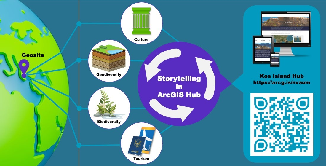
This paper presents the implementation of story mapping technology in the development of an interactive, user-friendly web-GIS collaboration platform known as a “hub” for the island of Kos, Greece, found at
https://arcg.is/nvaum (accessed on 12 June 2023). More specifically, a general presentation of the area’s history, geology, natural and cultural heritage is provided, followed by the methodology for the creation of the hub. A complete description of the individual themes of interest (the StoryMaps of the hub) is also given, along with relative screenshots. The aim is to enable users from all backgrounds and levels of expertise to explore both the natural and anthropogenic environment of Kos and discover its unique geological history, which is inextricably linked to the island’s biodiversity and cultural development. In addition, the platform engages a variety of activities such as hiking, cycling and water sports, which are presented here in 2D and 3D representations. In this way, an entertaining and leisure-oriented virtual tour of the island is made possible, and a basic plan is created for future geologists, tourists, nature lovers and the public to explore upon their visit, including the possibility for locals to rediscover their island from a different, modern perspective. Finally, the authors discuss the applicability of the method for similar environments and important areas with rich heritage, the advantages, and the possible limitations of the approach, and then they give their final remarks and conclusions.
2. Study Area
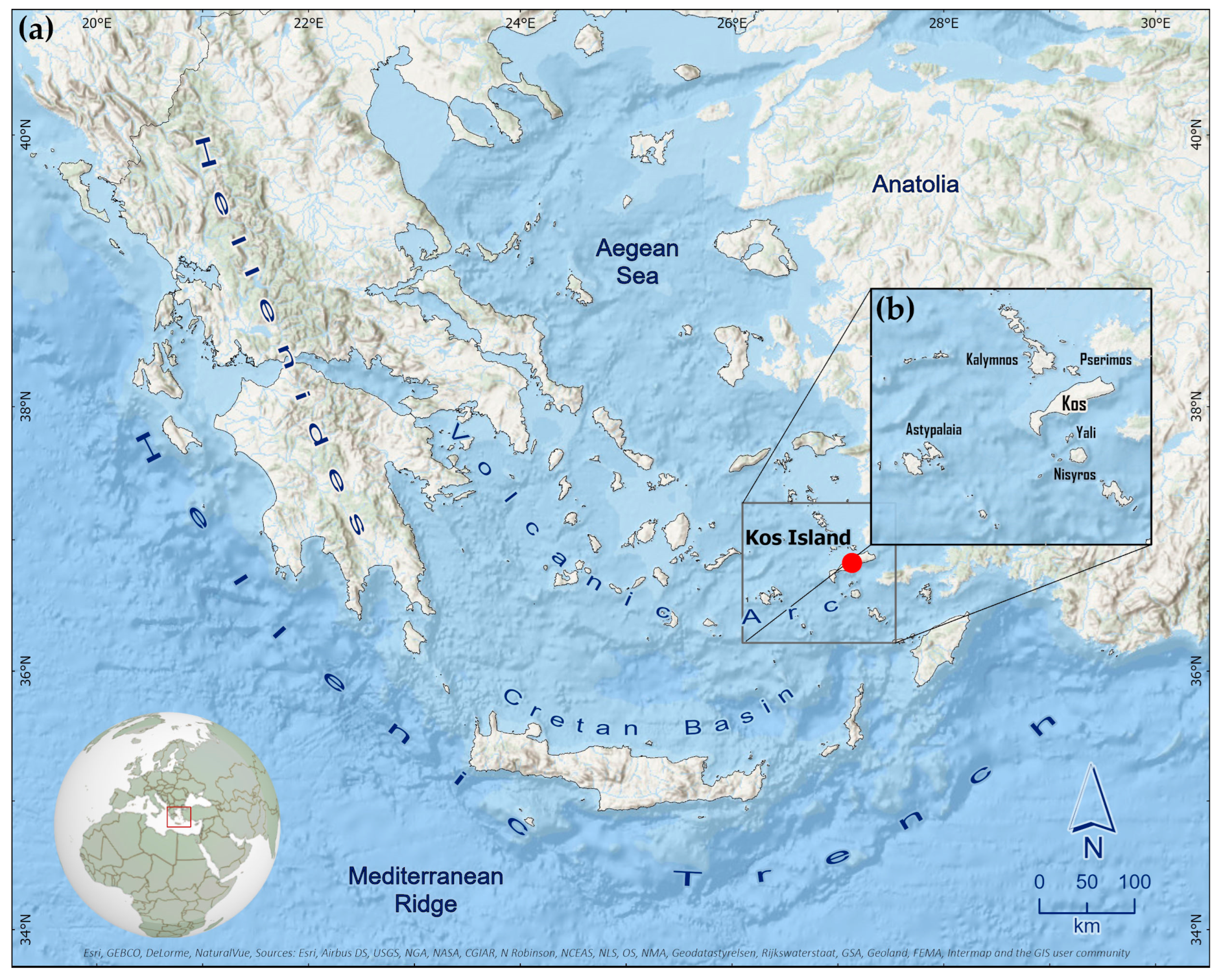
The island of Kos is in the SE part of the Aegean Sea and belongs to the Dodecanese Island complex of Greece. It is the third largest island of the Dodecanese (287.2 km
2) and is surrounded by Kalymnos and Pserimos to the north, Astypalaia to the west, Asia Minor to the east and Nisyros together with Yali to the south (
Figure 1). The shape of the island is elongated, oriented NE-NW. It has a 112.2 km long, predominantly sandy coastline with large bays.
A rich hydrographic network traverses the surface of the island and contributes to the formation of the present topography, which is characterized by the graben–horst pattern created and controlled by active marginal faults (see
Section 4 ‘Information Sharing (WebGIS Platform)’ for more). The catchments of this network extend over a limited area, as the tributaries of the main rivers are short and denser in the northern part of the island. Most of the island’s hydrographic systems develop on both sides of the main watershed in parallel directions, mainly NW-SE [
30].
As for the climatic conditions in the wider area, they have been mild since ancient times and have the characteristics of the Mediterranean climate. The average annual temperature is 18.7 °C, solar radiation is abundant and average rainfall is relatively high at about 750 mm/year, which contributes to the formation of abundant water resources [
31].
Geologically, Kos, together with Nisyros, Yali and the surrounding islands, forms the southeastern part of the active South Aegean Volcanic Arc (or Hellenic Volcanic Arc), a chain of volcanoes formed by the ongoing subduction of the African plate beneath the Eurasian plate to the north. The two plates converge at a rate of about 35 mm/year, as measurements from GPS show [
32]. The most active section starts in the southwest of the island of Kefalonia in the Ionian Sea, continues towards the southeast by passing south of Crete and ends in the southeast of Rhodes.
As a result of subduction, active volcanism manifests itself about 250 km north of the southern plate convergence boundary along the Hellenic Volcanic Arc, resulting in a chain of volcanoes about 600 km long and 20–40 km wide (
Figure 1). It extends from the Saronic Gulf near Corinth to the islands of Kos and Nisyros on the west coast of Asia Minor. It consists of the volcanic centres of Sousaki, Aigina, Methana and Poros in the west, Milos and Christiana–Santorini in the south and the Kos-Yali-Nisyros volcanic field in the southeast, together with other coastal volcanic structures discovered after an extensive and systematic exploration of the Aegean seabed [
33].
Due to its advantageous location on the southeastern Aegean Sea and the eastern Mediterranean Sea, as well as its Mediterranean climate, Kos is characterized by diverse natural beauty. Its unique biodiversity includes rare endemic species of flora and fauna as well as immigrant species, as it lies at the crossroads traversed by birds from Asia and the Middle East on their way to Greece, southern Europe and vice versa [
34,
35,
36]. Important biodiversity thriving locations are the wetlands of Alyki and Psalidi, the rich forests covering Mount Dikaios and the mountains of Kefalos, the drier areas of the Antimachia plateau and the coastal and marine environments of the island. The combination of sea, mountains, and its large size account for the island’s rapid development and provide a basis for alternative, sustainable forms of environmental tourism.
As for its rich cultural heritage, Kos is the only island in the Dodecanese that has been inhabited since prehistoric times, due to its long history that began in the third millennium BC. Many preserved archaeological monuments, settlements and ruins testify to the passage of all civilizations that have shaped the island’s historical path and mythology. Nowadays, the long historical past and deep spirituality of the people of Kos are also evidenced by numerous religious sites such as churches, monasteries, and mosques, which make the island a major centre of religious tourism.
The island’s coastline today features several organized sand and gravel beaches offering a wide variety of maritime activities including surfing and scuba diving. Its unique geological, cultural, and spiritual heritage as well as its thriving environmental land and marine ecosystems are accessible by a sufficient and functional road network and an extensive network of well-preserved hiking trails and cycling routes, for which Kos is particularly famous.
3. Materials and Methods
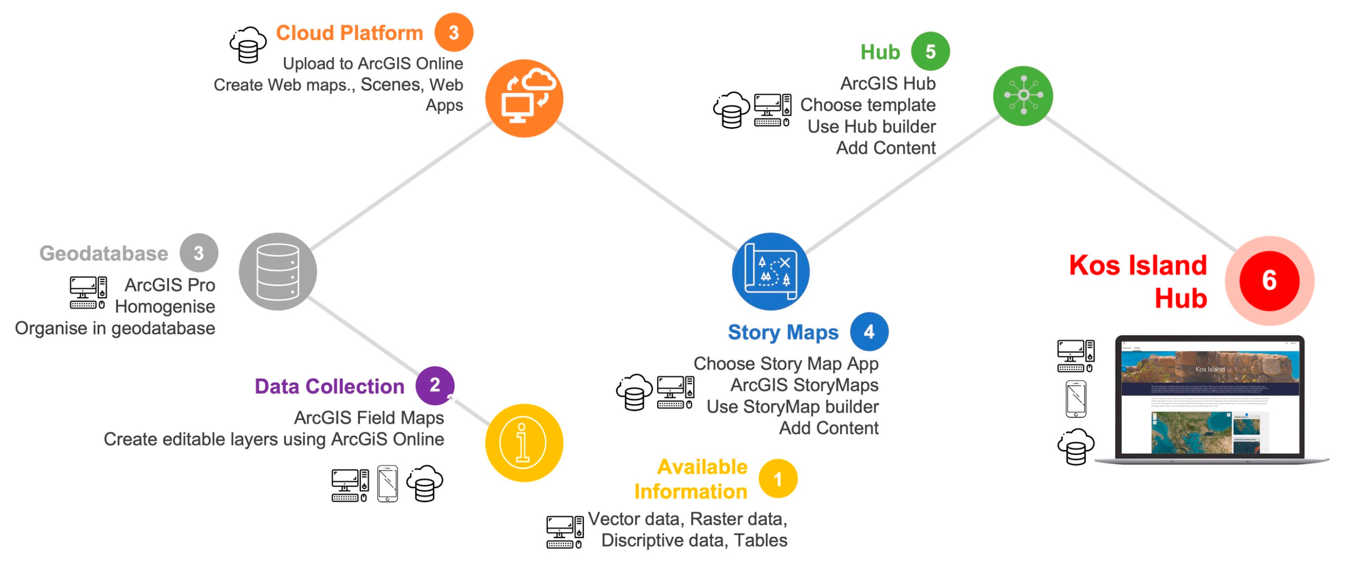
Creating a hub that promotes the cultural and geological heritage of Kos for education, training and conservation purposes is a valuable initiative. To achieve this, the study focused on a holistic approach by gathering datasets that concern not only the island’s geological features but also the cultural elements and the various maritime and other activities that define Kos, thus presenting both the natural and anthropogenic environment of the island. To create the hub, different types of datasets were compiled, new or existing, either from private or open-source portals. In addition, several data collection field trips were undertaken to record the exact location of each site, together with representative photos and videos, to enhance the existing geocultural knowledge.
All available information (analogue or digital) for the area (bibliography, topographic map, geological structure, etc.) was collected, homogenised, organised and finally converted into the WGS 1984 Web Mercator (auxiliary sphere) projected coordinate system and stored in an ArcGIS Pro software geodatabase (
Figure 2). ArcGIS Field Maps (
https://www.esri.com/en-us/arcgis/products/arcgis-field-maps/overview, accessed on 12 June 2023), available for both Android and iOS devices, was used to ensure the accuracy of the geographical location of the collected data during fieldwork. To this end, a second geodatabase was first created that contained the two vector feature classes intended for data collection: a point database to store spatial and descriptive data for each location of interest along with multimedia content, and a polyline database to track the location of the existing trail network using the GPS signal. The next step was to release a web map created via ArcGIS Pro with imagery as the base map and the two feature classes mentioned above on the ArcGIS Online platform, while setting individual parameters for each of the information layers, e.g., their symbol and the appearance or nonappearance of tags and pop-up menus, etc., as well as their update interval.
To bring all the available information about Kos Volcano Island to the public more efficiently, a specific medium had to be found through which the information could be collected in one place, grouped, and disseminated worldwide via the Internet. After reviewing the available options, a WebGIS platform using ArcGIS Hub (
https://hub.arcgis.com/, accessed on 12 June 2023) was deemed the best choice because of: (a) the authors’ previous extensive experience with ESRI products, (b) the extensive use of the ArcGIS platform throughout the project, and (c) the ability to add external media and other applications developed within the ESRI platform. ArcGIS Hub, developed by ESRI in 2020, is a platform that enables the creation of interactive sites through which its spatial content can be shared. All team members can customise and enhance the developed site with 2D and 3D maps, smart layouts, templates, and multimedia content that can be configured to better present the available information. A personal account was used to create Kos Hub, which is accessible in two languages, English and Greek, at the following address:
https://arcg.is/nvaum (accessed on 12 June 2023).
Nowadays, there are many web platforms that allow the development of a storytelling app, each of them offering different methods of data processing and visualisation (e.g., TimeMapper (
http://timemapper.okfnlabs.org, accessed on 12 June 2023), thinglink (
https://www.thinglink.com/, accessed on 12 June 2023), Odyssey by CARTODB (
https://github.com/CartoDB/cartodb, accessed on 12 June 2023), Google Earth Outreach (
https://www.google.com/earth/outreach/, accessed on 12 June 2023), StoryMapJ (
https://storymap.knightlab.com, accessed on 12 June 2023)). Some of the available options may require third-party applications to incorporate different presentation styles, while others may also require coding. However, some platforms, such as ESRI’s online platform used for this geological site promotion, provide all the tools needed to efficiently process all the data without the need for additional software to achieve the desired result. In addition, the fact that all the previously mentioned data was created and stored on Esri’s platform (desktop and online) led us to use an Esri product. Esri offers several configured apps based on open source, as well as a new story map template that combines popular features from those previously mentioned. These can either be used as they are (or with minor CSS code changes in ArcGIS Assistant) via ArcGIS Online or downloaded via GitHub, modified, and then deployed via a private server [
37]. In deploying this story map, the first approach was taken, not only because of the large number of users expected to visit the application, but also due to the lack of a private server to manage it.
In terms of visual output, the new story map approach called ArcGIS StoryMaps has been implemented to present the available information as it offers a user-friendly interface with a responsive design and advanced features. In addition, the ArcGIS StoryMaps template has many important accessibility features to support readers with limited vision or mobility. Furthermore, due to the wide variety of information that needs to be presented, eight categories were defined, one for each knowledge topic, and a guided linear narrative through immersive scrolling [
38] was used as this is more effective for users than jumping from one tab to the next without a sequence [
39].
Finally, narrative texts with images, accompanied by 2D and 3D web maps created in ArcGIS Pro according to the appropriate cartographic rules [
40,
41], and embedded content from other web apps were combined into an engaging experience via the app’s interactive builder, as described in the following section (
Figure 2).
4. Information Sharing (WebGIS Platform)
Due to the large amount of information available about the island of Kos, it was considered useful to create a simple structure on the hub so that users can easily access the thematic knowledge that interests them most, as described below.
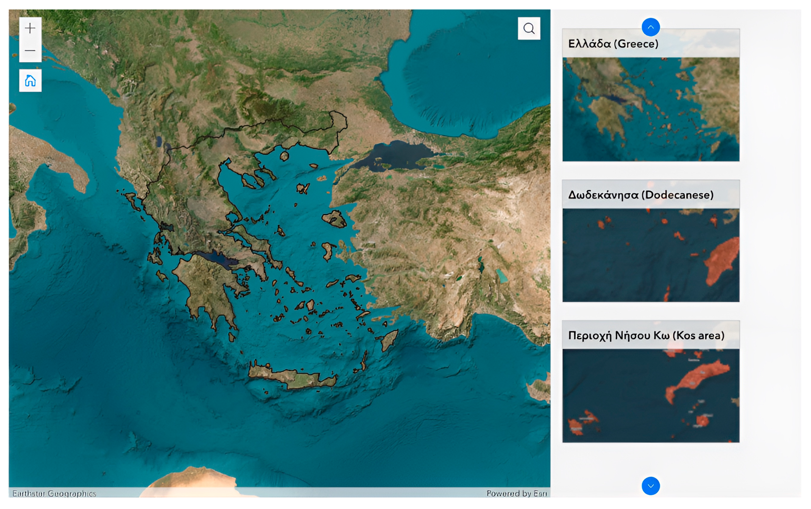
The narrative begins with a photograph of the remains of an early Christian basilica on Kos, followed by a brief introduction about the purpose of the Hub. Scrolling down, the user can read information about the location of Kos Island and walk through an ArcGIS web experience app (
https://www.esri.com/en-us/arcgis/products/arcgis-experience-builder/overview, accessed on 12 June 2023) with an interactive two-dimensional web map outlining the boundaries of the Greek territory and containing imagery as a base map to explore the area spatially. The user not only can navigate through the web map, but also can select the bookmarks on the right to zoom directly into specific areas (
Figure 3).
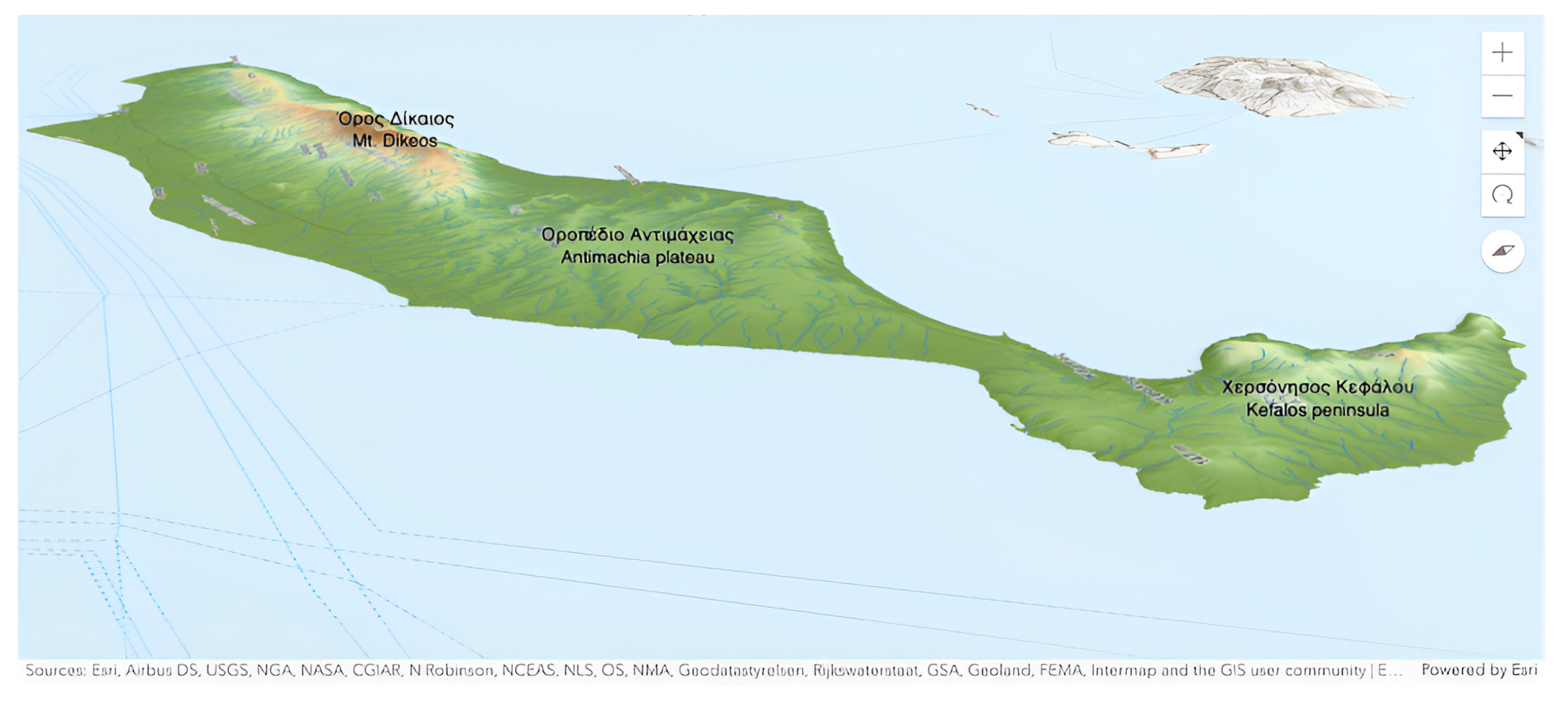
Following the narrative, the morphological features, the geological and tectonic structure, and the mineral wealth of the island are briefly presented. The relief of the island can be divided into four separate sections (
Figure 4): (i) The Kefalos peninsula (west of Kos) has an irregular relief with abrupt morphological slopes due to the presence of high rhyolitic domes, (ii) the flat surface of the Antimachia plateau from the Volcania area to the western flanks of Mount Dikeos (or Dikaios) with an average height of about 120 m, (iii) the imposing mountain range of Dikeos, which covers the SE part of Kos and reaches a height of 843 m, with rough morphological slopes and (iv) the smooth relief of the NE coastal zone of the island [
30].
To underpin the narrative, an interactive three-dimensional web map (scene) is rendered by elevation, based on a 5 m resolution digital elevation model from the National Cadaster and Mapping Agency S.A. of Greece, and a multidirectional shaded relief map (
Figure 4). The representation of the morphology is completed by the hydrographic network that crosses the surface of the island and the main topographic features. The viewer can zoom in and out using the tools on the map, or right-click anywhere on the map to tilt and rotate the scene and view it from different angles. Both the two-dimensional and three-dimensional (scene) web maps were created using the ArcGIS Online platform (
www.arcgis.com, accessed on 12 June 2023).
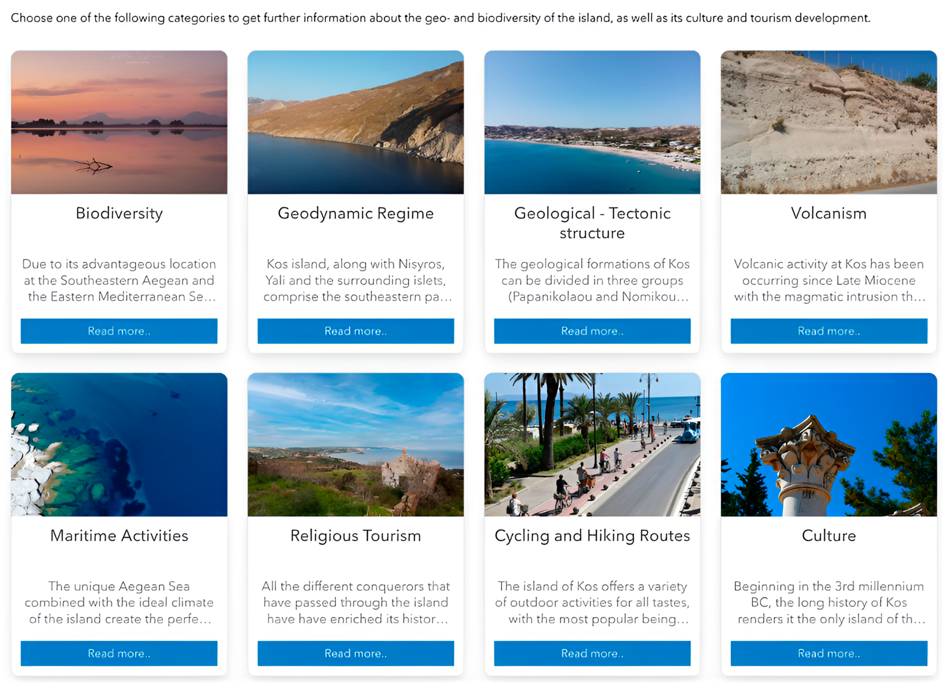
The last part is devoted to a gallery that includes all eight fields of knowledge (
Figure 5). Buttons allow the user to access an individual ESRI Story Maps application dedicated to each of these fields. The value of using such applications to illustrate and promote available information for an area is based on previous related applications of this type and those used by some of the authors of the present work as mentioned before.
The structure and content of the individual StoryMaps are described in more detail below.
4.1. Biodiversity
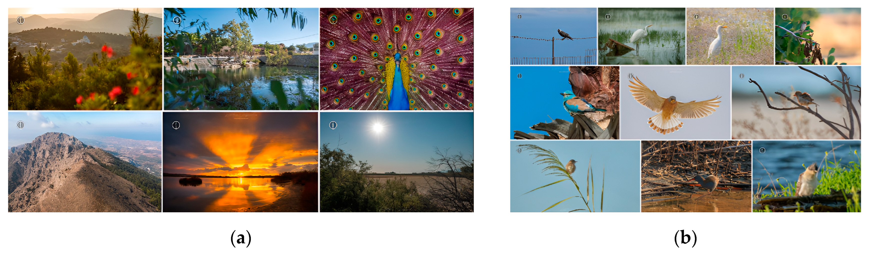
The Kos Island Hub’s first individual story map showcases the island’s rich biodiversity, featuring more than 950 volunteer species of flora including rare orchid and herb species as well as forests, and a significant number of fauna and avifauna [
34]. The information is divided into three main sections: Protected Areas, Flora, and Fauna. In each section, the officially designated protected areas of Kos are described in detail at the international and national levels. This is followed by a description of the main animal and plant species found on the island, complemented by representative high-resolution photos and videos of the species mentioned and their habitats (
Figure 6). The island’s rich biodiversity is mutually linked to its topography and its geographic location. During the Pleistocene ice age cycles, the sea level was lower than today, and Kos was part of the Asia Minor mainland, the proximity thus leading to some species of flora and fauna having their westernmost spreading at Kos [
34].
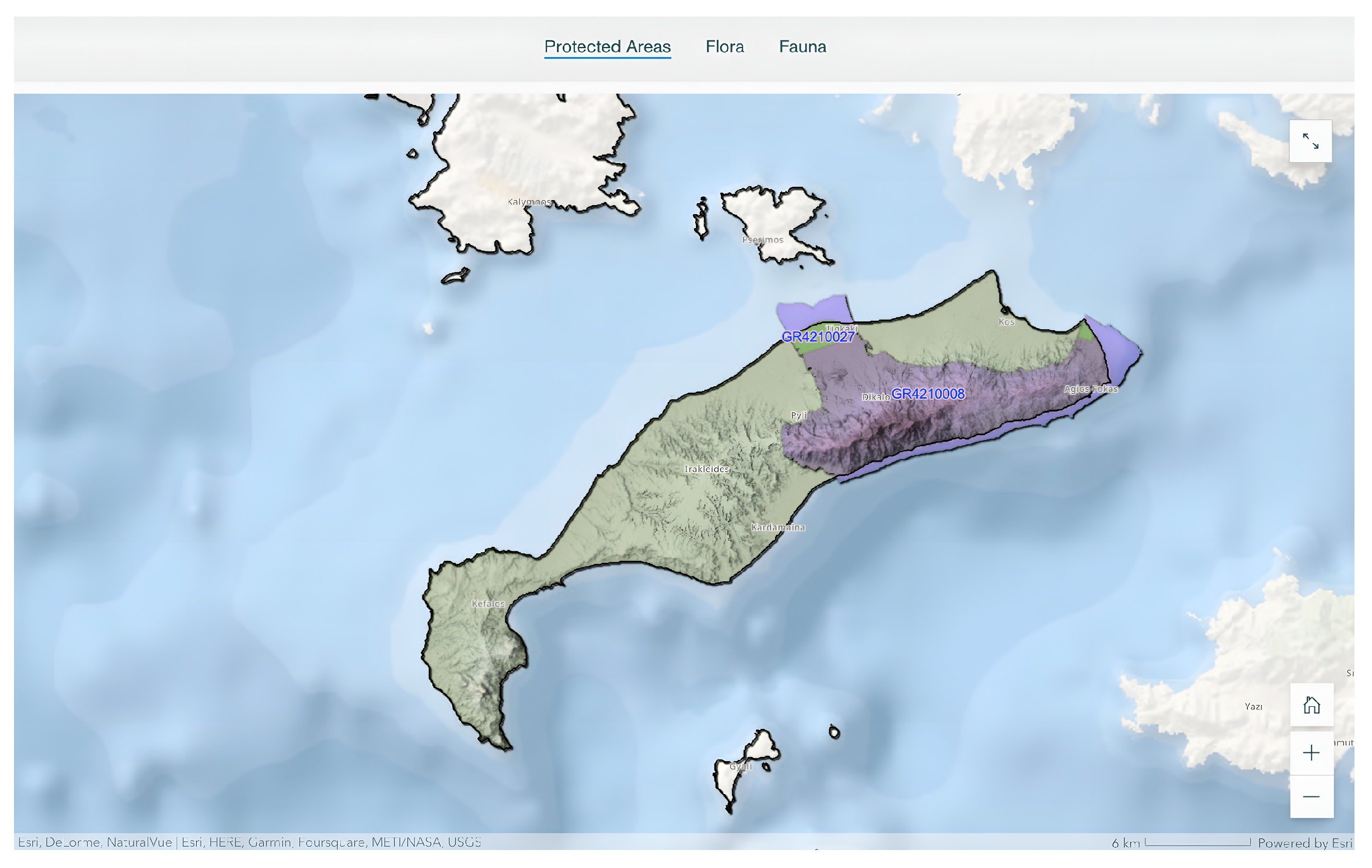
Two two-dimensional web maps were also used to represent aspects of Kos’s biodiversity: the first showing regions that are part of the European ecological network Natura 2000 (
Figure 7) and the second Wildlife Refuges and Places of Significant Natural Good, overlaying a multidirectional hillshade of the island with a resolution of 5 m and using an Ocean or World hillshade as a base map. Users can interact by selecting an area to view available information or by using the tools on the right side of the map to focus (lower right) or zoom (upper right). The legend, if available, can be activated using the tool on the left side of the map.
4.2. Geodynamic Regime
The following three individual Story Maps of the hub are dedicated to the complex yet interesting geology of Kos, starting with the general geodynamic regime of its broader region. This is necessary because to accomplish a balanced, successful dissemination of geoscientific results for all types of audiences, the narrative needs to first guide users through the main geodynamic factors that formed the island before diving into its more specific geological features. As a result, the Geodynamic Regime Story Map sets off with an aerial image of Dikaios Mountain, shot from the south looking northward. Narrative text then describes the geodynamic characteristics of the subduction of the African plate beneath the Eurasian one, resulting in the formation of the South Aegean Volcanic Arc (or Hellenic Volcanic Arc), part of which is Kos. Users learn about the most famous volcanic centres of the arc and understand its southward migration within the geodynamic space of the Aegean over the past 55 million years. The text is enhanced by the presentation of three illustrative figures showing a geodynamic map of Greece with the main faults and relative movements, a schematic cross-section of the subduction zone and the volcanic arc as well as an easy-to-understand figure, presenting the migration of the arc and indicating past locations of volcanoes in Greece.
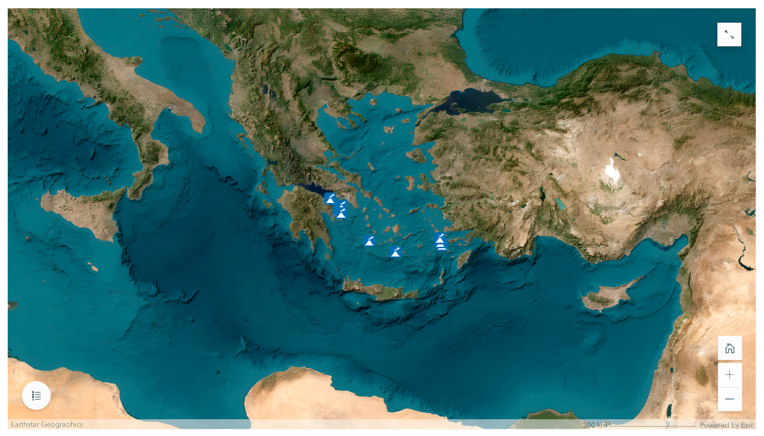
The StoryMap is complemented by a two-dimensional web map presenting the geometry and distribution of the volcanic centres along the arc, using high-resolution satellite imagery as a base map (
Figure 8). Users can select a volcano on the map to view more information or use the tools at the right side to focus (lower right) or zoom (upper right), thus allowing for an easy interactive exploration. The map’s legend can be activated by the tool located at the left side of the map.
4.3. Geological–Tectonic Structure
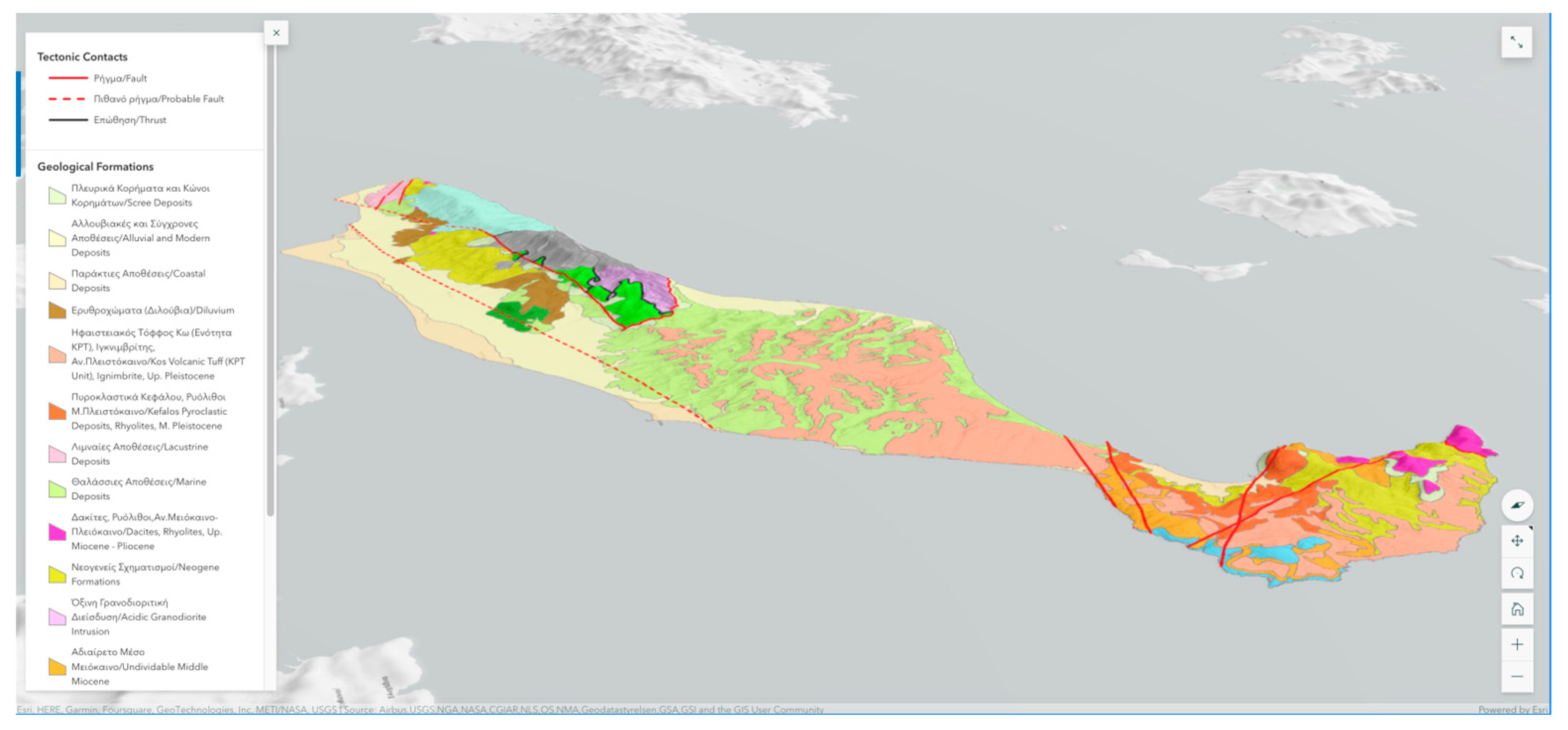
The next Story Map relates to the specific geological and tectonic characteristics of the island, because of complex events that have been taking place for more than 400 million years. Kos is part of the Hellenic Volcanic Arc and, hence, has hosted volcanic erupted events whose products cover most of its surface. However, the goal of this StoryMap is to introduce users, for the first time in such a manner, to the nonvolcanic geological heritage of the island. As a result, the Story Map focuses on the different types of rocks found at Kos (Alpine, post-Alpine and volcanic rocks) as well as its tectonic structure, with information grouped in two main sections: Geologic Structure and Tectonic Structure. In the beginning, a three-dimensional web map (scene) is used to present the spatial distribution of geological formations along with the tectonic structure, overlying a 5 m resolution shaded relief, using a 3D terrain as base map (
Figure 9). Users can select a geological formation on the map to view more information or use the tools at the right side of the map to focus (lower right) or zoom (upper right). The legend is activated by the tool located at the left side of the map.
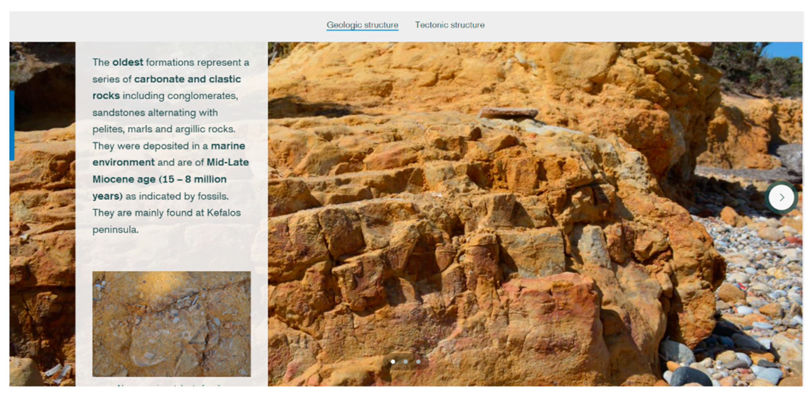
In the first section, an in-depth presentation of the Alpine and post-Alpine geological units of Kos is given, each time highlighting the name of the unit, the individual types of rocks it contains, their absolute or relative age as well as other interesting highlights that make Kos stand out geologically. The text is accompanied by high-resolution field photos and videos showcasing representative examples from rock outcrops, individual rocks as well as fossils found across the island, thus dominating the narrative. Users can explore the different geological units in the form of two slideshows, one for Alpine and one for post-Alpine rocks, each slide of which contains information regarding an individual unit (
Figure 10).
The second section describes the geotectonic setting as well as the main fault zones that dominate the island, resulting in a complex graben–horst system of individual tectonic blocks. Each block is specifically presented, including its relative location and main kinematic features. The text is accompanied by a geotectonic map of the broader marine area of Kos as well as a schematic illustration of the main tectonic blocks of the island. As a result, users learn that all the different mountains and plains that characterize the complex geomorphology of Kos resulted not only from volcanic activity, but also from the constant movement of the crust along faults. The narrative ends with a photo and an aerial video presenting the most typical example of a horst at Kos, Dikaios Mountain.
4.4. Volcanism
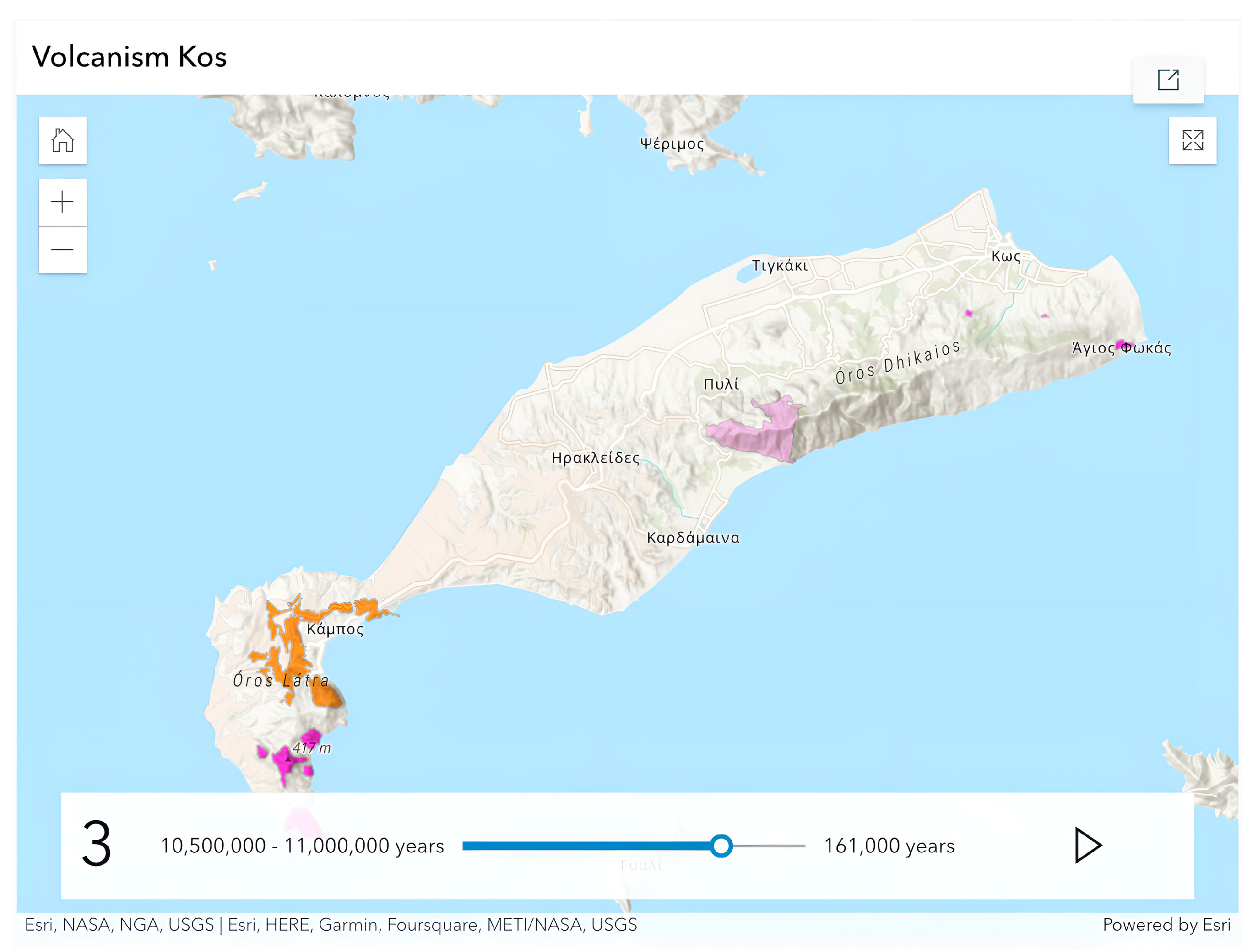
The final geology-related StoryMap within the hub is dedicated to the magmatic activity on the island. As early as 10.5 million years ago [
42,
43], a series of plutonic intrusions and volcanic eruptions contributed significantly to the present-day morphology of Kos, gradually culminating in the ‘Kos Plateau Tuff’ eruptive events 161,000 years ago, the most voluminous eruptive event in the records of Eastern Mediterranean volcanic activity [
44]. The narrative text presents in an easy-to-understand manner the series of magmatic events in chronological order, starting from the Late Miocene plutonic granodioritic intrusion at Dikaios, and then proceeding to the Pliocene and Pleistocene volcanic events of Kefalos Peninsula and, finally, to the KPT eruptive events, the products of which dominate the Antimachia Plateau. Modern-day hydrothermal activity and the island’s thermal springs are also presented. High-resolution photos and videos accompany the text, with representative examples of volcanic rocks as well as underwater ROV footage at the Empros Thermes thermal springs.
The StoryMap is enhanced by a Slider Instant App, part of the ArcGIS Online portfolio, that was used to showcase the evolution of volcanic activity at Kos through time (
Figure 11). Users can interact by selecting the Play button or manually moving the slider to explore the spatial distribution of volcanic formations in a certain timeframe.
4.5. Maritime Activities
The Aegean Sea combined with the Mediterranean climate of the island provides for all kinds of maritime activities, making Kos ideal for travellers, as the island attracts thousands of visitors every year. The available information on maritime activities has been divided into three main categories, beach water sports, fishing shelters and scuba diving tourism, while drone footage shows representative views of the coastline.
As the third largest island in the Dodecanese, Kos has a rich coastline with countless beaches. The best organized beaches are located mainly in the northern part of the island, but also near the residential areas. For almost everyone, there are water sports for all preferences and ages, such as kitesurfing, windsurfing, jet skiing, parasailing, pedal boating, stand-up paddling (SUP) and kayaking. The southern coastline also features several thermal springs, the most important of which are emitted at the Empros Thermes beach, a direct heritage of the island’s volcanic past. A two-dimensional web map shows the location of beaches and water sports facilities on a digital elevation model with a resolution of 5 m and a multidirectional hillshade of the island, using the World Hillshade as a base map. Users can interact with the web map by selecting a location on the map to get more information, or by using the tools on the right to zoom in (top) or change its focus (bottom) and on the left to access the legend.
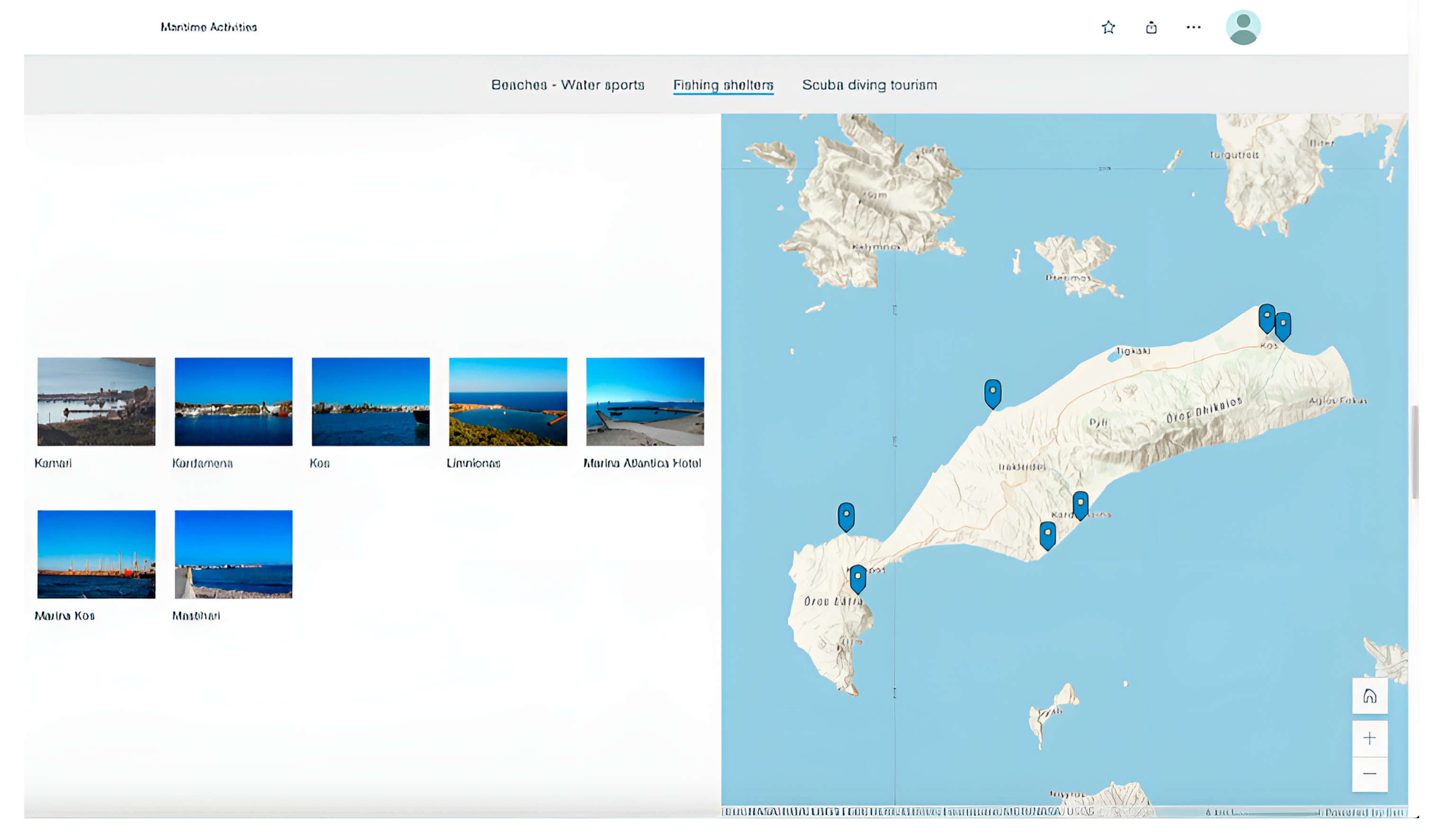
In addition, the sea and the coast of Kos offer the opportunity to sail among the beaches, anchor in natural bays or swim safely. A Map Tour, Experience Layout immersive tool is used to showcase the fishing shelters around the island (
Figure 12). Users can explore the shelters in any order by either selecting a highlighted location on the web map to see a representative photo of the shelter or selecting one of the available photos to see the shelter’s location on the map.
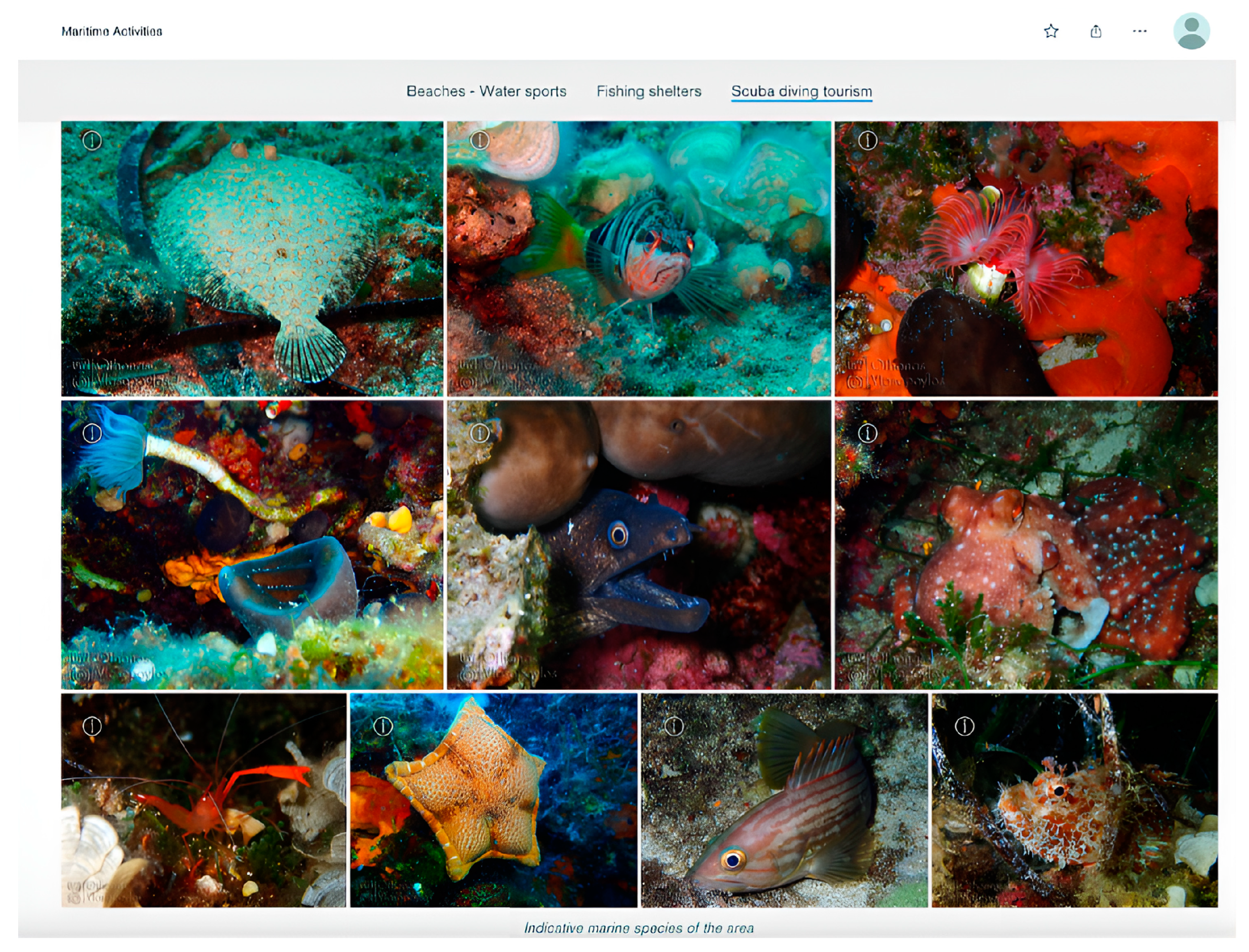
The geomorphological, marine, and environmental conditions prevailing in this area provide an unusually high biodiversity and productivity of marine habitats, making the bottom of Kos a popular diving destination. In addition to representative photos in a Jigsaw Gallery showing the characteristic marine species of the area (
Figure 13), a two-dimensional web map shows the location of the five internationally certified diving centres that have the necessary expertise, equipment, and properly trained personnel to satisfy divers of all levels. Again, the 5 m resolution digital elevation model with a resolution of 5 m and the multidirectional hillshade map of the island were used, along with the World Hillshade as a base map. Users can interact with the web map by selecting a location on the map to get more information or use the tools on the right to zoom in (top) or change its focus (bottom).
4.6. Religious Tourism
Various conquerors have enriched the history of the island, creating a varied religious environment with Christian churches and Ottoman mosques. During the Byzantine era, the old temples were razed to the ground and Christian churches took their place, while with the Ottoman invasion mosques became a widespread place of worship. Today, all over the island of Kos, countless churches, chapels, important monasteries, and impressive Muslim mosques bear witness to the island’s historical past.
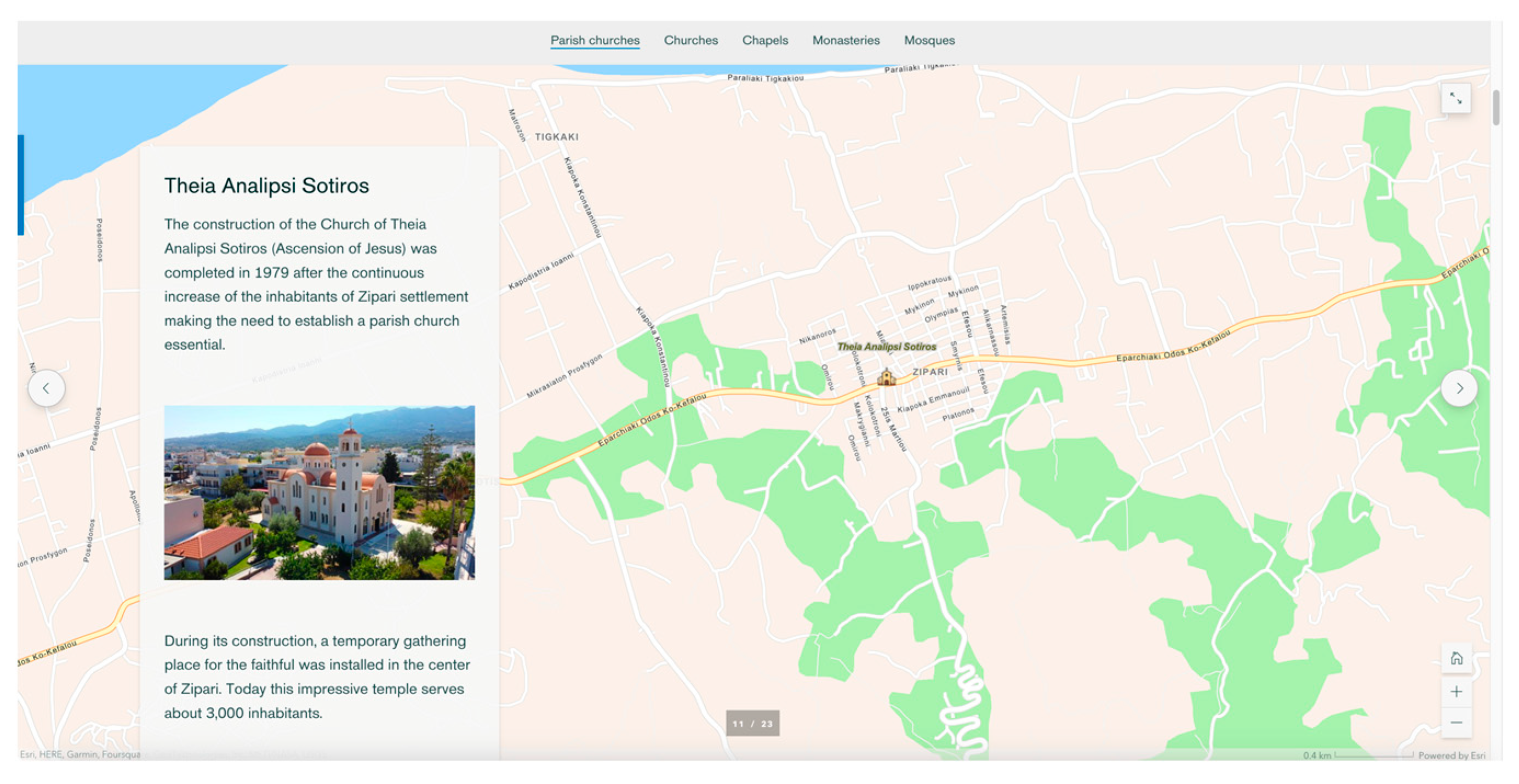
Christianity spread on Kos quite early, as evidenced by the preserved monuments of early Christian basilicas on the island. This is due to the geographical position of the island, which was an important stop on the sea route between Alexandria and Constantinople. Nowadays, the dozens of Christian churches on the island testify to the deep faith and spirituality of the inhabitants of Kos. The extensive network of Christian churches on the island serves hundreds of worshippers every day. The parish churches, the countless chapels, and the important holy monasteries of Kos, such as the little church of Christos Dikeos built on the top of Mt. Dikeos, are an integral part of the religious life of the Koans and attract numerous believers. Muslim mosques can also be found at Kos, also remnants of the island’s rich history and diachronic cultural diversity.
The immersive tool Sidecar was used to present parish churches, monasteries, and mosques. In each Sidecar, a two-dimensional web map, which included a World Navigation map for the first two and an Open Street Map base map for the last, were used to overlay the location of these religious testimonies. For each site, a representative photo or video was included along with explanatory text to supplement the available information. For parish churches and mosques, users experience the Slideshow layout in which text and additional media are static over the main media, while clicking on the available arrows allows them to move the slides horizontally (
Figure 14). For monasteries, on the other hand, the Floating layout was used, in which text and additional media scroll over the main media filling the background, i.e., the web map.
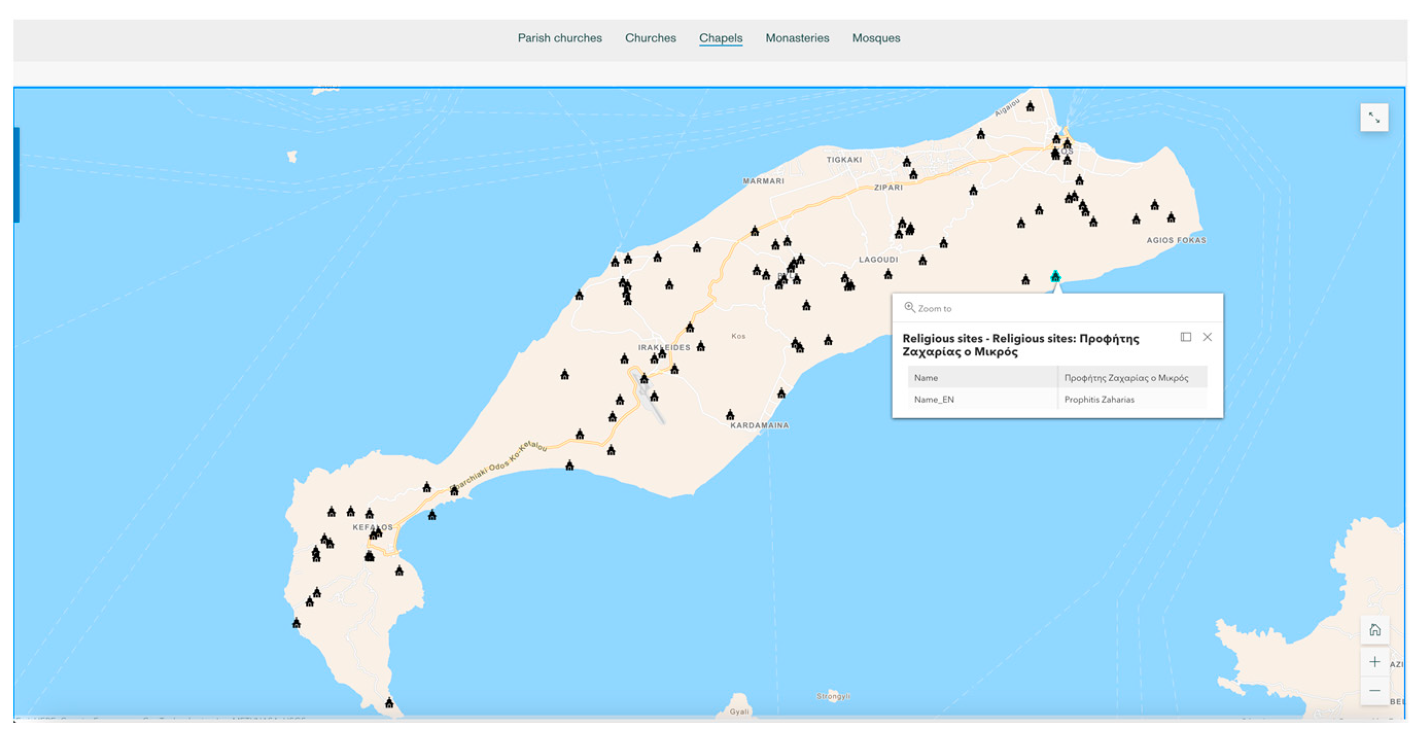
The World Navigation Map was also used as a base map to overlay the location of chapels and churches (non-parish) on a two-dimensional web map showing their spatial distribution across the island (
Figure 15). Users can also select a location to open a pop-up window with more information, such as the name of the location in both languages, or/and use the tools on the right to adjust the zoom level of the maps.
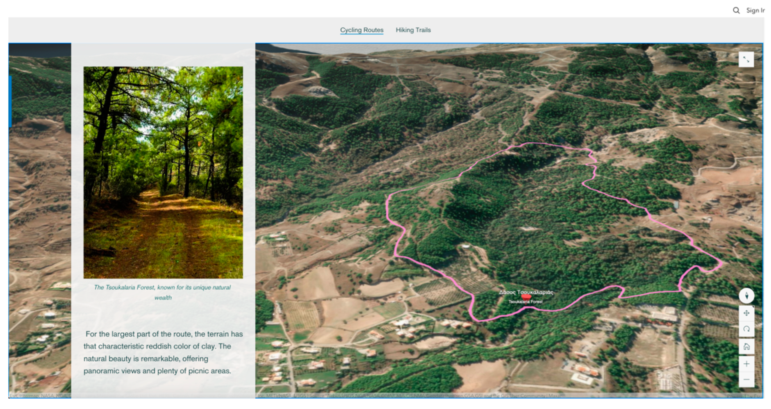
4.7. Cycling and Hiking Routes
The geomorphology of an area greatly determines whether it is suitable for the creation of cycling and hiking routes. A region characterized by diverse landforms and varied topography can provide ideal conditions for both activities. A mix of flat stretches, gentle slopes and challenging ascents can offer a range of difficulty levels to accommodate cyclists of different abilities, while scenic landscapes can enhance the overall experience for cyclists, providing visually appealing surroundings. Similarly, an area with diverse geomorphology can offer a range of trail options, including easy walks through flat terrain, moderate hikes through undulating landscapes or more challenging treks through mountains. On that account, the varied topography of Kos played a major role in the creation of its extensive network of cycling and hiking trails.
The gentle and smooth relief of the island’s NE coastal zone and the relatively flat terrain of the Antimachia plateau host an abundant number of hiking trails and cycling routes that are relatively easy to follow, while the rough terrain of Mount Dikeos and Kefalos Peninsula offer trails that have a higher level of difficulty and are better suited for more experienced cyclists and hikers. That is why, for decades, Kos has been known as “the island of bicycles”, while in the town of Kos, having a vast cycling road network since the beginning of the 20th century, the commuting by bicycle became a popular means of transportation, as the local authorities state at the official website of the municipality of Kos (
kos.gr).
Today, Kos has well-maintained routes and paths where visitors can explore the forests, mountains, wetlands, and famous thermal springs and learn about the history of the island through the archaeological sites, castles and churches that can be found along these paths. Kos has routes for cyclists of all levels, and the hiking trails are easily accessible to anyone with a relatively good physical condition. The rich flora and fauna, the mountain villages, the diverse architecture, and the views of the Aegean Sea are just some of the experiences offered by the hiking trails in Kos.
The immersive tool Floating Sidecar was used to present the cycling and hiking routes on the island (
Figure 16). A three-dimensional scene was created for each category using Imagery and 3D terrain as base map underneath the spatial representation of routes and noted toponyms. Representative photos and descriptive text complete the available information. Users must follow the scrollable narration to access all routes, while having the ability to rotate and tilt the scene or define the zoom level using the available tools on the right.
4.8. Cultural Values
In Kos, monuments from the mythological era of Hercules and King Harmylos are exhibited, as well as monuments from the Hellenistic period, such as the ancient agora, the ancient stadium, the altar of Dionysos and the famous Asclepieion. The Roman conservatory and the Roman house from the period of the Roman Empire, the early Christian basilicas of the Byzantine period that have been identified on the island, as well as the imposing castles of Neratzia, Antimachia, Kefalos and Palaio Pyli as remains of the Crusader period and of the Venetian conquerors, have determined the historical identity of the island. Additionally, the visitable cultural heritage monuments of the island, such as the folkloric museums and the traditional windmill of Antimachia, highlight the centuries-old history and traditional lifestyle of the inhabitants of Kos.
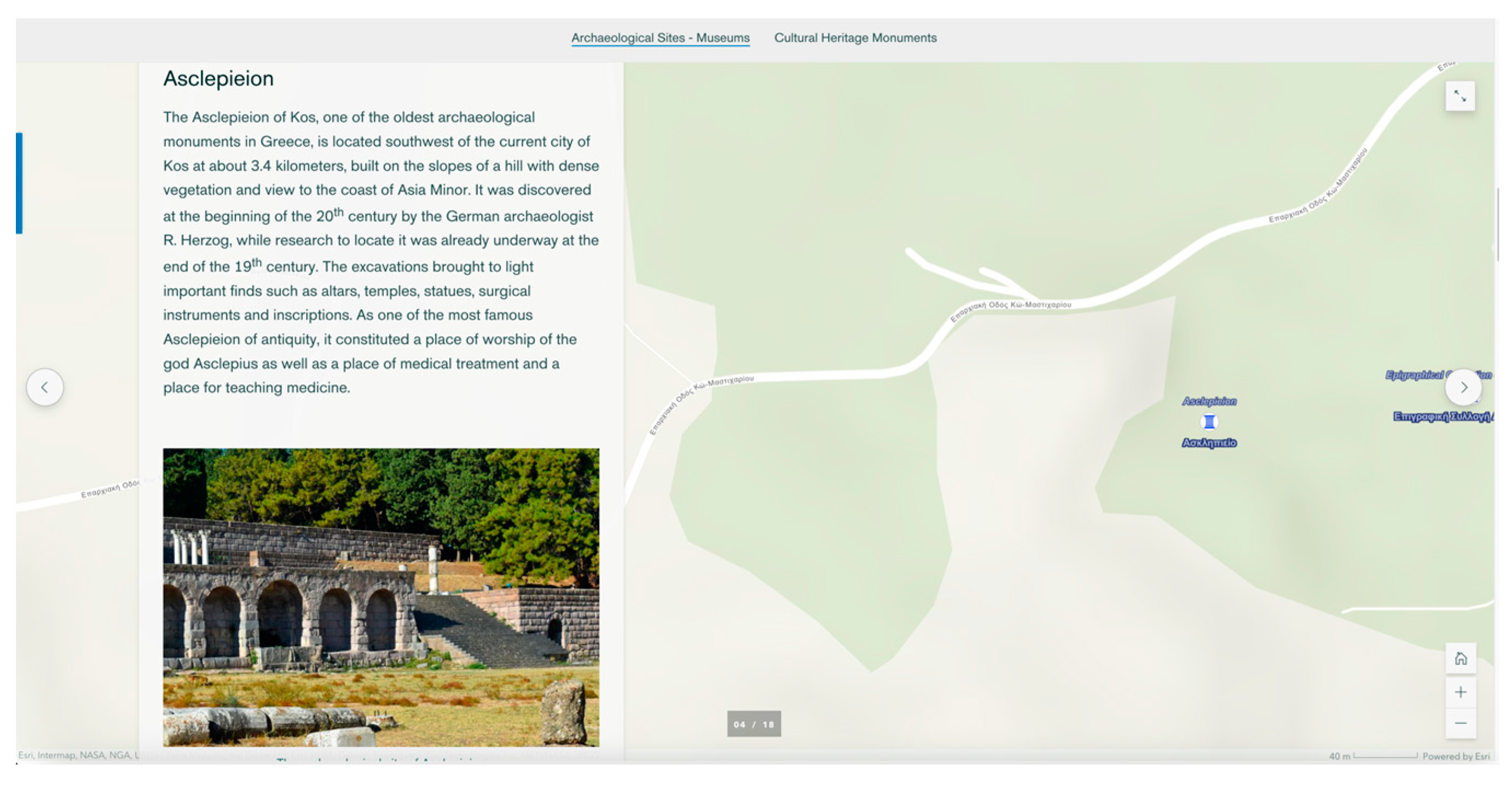
Worth mentioning is the Asclepieion of Kos, one of the oldest archaeological monuments in Greece and the most famous on the island ([
31,
45]), built on the slopes of a hill with dense vegetation and a view to the coast of Asia Minor. It was discovered at the beginning of the 20th century by the German archaeologist R. Herzog, and the excavations brought to light important finds such as altars, temples, statues, and inscriptions made of local Koan marble coming from the island’s large marble deposits. As one of the most famous Asclepieia of antiquity, it constituted a place of worship of the god Asclepius as well as a place of medical treatment and a place for teaching medicine.
Numerous medieval fortresses are in particularly strategic positions, such as the Castle of Antimachia. The Castle of Antimachia was built by the Knights Hospitaller of St. John at the beginning of the 14th century AD on the plateau southeast of the settlement of Antimachia ([
31]). At an altitude of 166 m, the fortress offered a panoramic view of the Aegean Sea, thus reinforcing the island’s defences, while also serving as a prison for condemned knights. Although the geomorphology of the area does not have natural features of fortification, it is a strategically important position that can visually control the strait between Kos and Nisyros, a busy maritime road of that period, as well as the plain of Kardamena, thus completing the island’s fortification.
The Slideshow Sidecar immersive tool was used to present a set of important Archaeological Sites—Museums as well as numerous finds that have come to light after excavation activities and highlight the ancient wealth of Kos (
Figure 17). The same tool was also used to display the cultural heritage monuments that have been preserved on the island, since Kos has always been a crossroads of cultures, where ancient, Ottoman and Venetian aesthetics coexist harmoniously. For each Sidecar, World Topographic Map and Hillshade serve as base map, to host the exact location of each site, while the available information was added using descriptive text and representative photos and videos. Users interact with the Sidecar either to continue the narration or to define a different zoom level.
5. Discussion and Concluding Remarks
In today’s world, it is crucial to provide adequate scientific knowledge on geological topics so that people begin to perceive their different, ever-changing landscapes, among other things. Geological processes have been continuously forming the environment where human activity takes place and are directly connected to many natural disasters that have a negative impact on human societies. It is the widespread, public-friendly scientific information on geoscientific issues that will ensure a stable foundation for the proper education of present and future generations on related topics, especially as the effects of climate change gradually become more apparent. It also plays a vital role in the further sustainable development of geologically important places, such as Kos which is presented in this paper, by raising awareness on topics related both directly and indirectly to the geology of an area.
The use of a WebGIS platform that allows the viewer to observe the overall distribution and arrangement of the available information in different scientific domains related to the study area is an added value compared to an unconnected dissemination. In addition, storytelling with maps, text and multimedia content has helped to disseminate data and information to all stakeholders in a visually engaging way, as shown by examples used to promote archaeology (e.g., [
46,
47]) or to enhance educational process (e.g., [
48,
49]). Story maps offer more interactivity compared to classic maps, allowing users to interact with and use the map to visualize the content of interest from different perspectives, while the narrative facilitates the transformation of data into information and eventually knowledge [
14,
50].
In this paper, a GIS application of the discussed virtual and interactive methods is presented, highlighting the complete geological, biological, cultural, and touristic potential of the island of Kos, Greece. Its aim was to highlight the importance of a geological area through its natural and anthropogenic environment. Grouping the available information into categories according to the knowledge area they belong to and presenting them using the StoryMaps app, a relatively new geographic visualization approach, offers many possibilities, both from the developer’s and the end-user’s point of view, due to the simplicity of the application. The authors have been able to integrate new features that connect many scientific domains and create an interactive, responsive web application in such a way that scientific knowledge can be absorbed and understood by a broader professional or nonspecialist audience of any age [
33,
51].
In particular, the Hub, but also the embedded individual apps, are responsive to screen size and allow for easy navigation, giving users the ability to interact with the maps and embedded media to an extent determined by the developers. In this way, they can easily explore the content using the available features built into the platform based on the chosen narrative method, such as tabs that group data by type, navigation buttons that control the available map views and popups that present specific information, usually describing points of interest. The information within each individual Story Map can also be further enhanced and/or restructured by the developers, without hindering users’ experience, thus allowing for complete maintenance of the platform whenever needed. However, certain limitations include restricted data analysis capabilities compared to dedicated GIS software and the reliance on Internet connectivity for viewing and accessing, which may limit the user’s accessibility in remote or low-bandwidth areas. Furthermore, being a relatively new tool, it gets constant updates that may detune the developer or even require debugging in an already running application.
The developed WebGIS platform can be an ideal way to present all the available information for any region, even for places that can be considered very touristy and want to introduce a new, more sustainable means of tourism, such as national and regional parks, geoparks or cities. By visiting a well-known island virtually, potential visitors will receive a strong motivation to explore the place up close in the future, thus contributing to its sustainable development, a crucial goal at both a national and an international level. WebGIS mapping applications for the general public’s awareness and education on topics such as geoheritage, culture, history and biodiversity are necessary, especially when it concerns a region with high extroversion and the associated risks for mass and unsustainable tourism. A scientifically informed public on a region’s heritage, their understanding of the mutual links between the separate areas of heritage and the combination of informative text, multimedia and interactive 2D and 3D thematic maps within a virtual, online environment easily accessible by computers, smartphones and other related devices that provides this knowledge can be a determining factor in future generations’ environmental way of thinking. It is impossible to shift the public and especially younger generations towards a more sustainable way of thinking and at the same time provide them with high-quality, easy-to-understand information on a topic without taking advantage of the outreach possibilities and the motivation WebGIS applications nowadays offer. They contribute to the goal of creating a new society of informed and aware people that will be able to support a complete and sustainable form of recreation by recognizing the complete value of an area and adding to it.
Proper scientific information communication tools and applications are the vital means through which otherwise inaccessible scientific data turn into information and eventually knowledge, providing a chance for a level of education that societies will recognize and incorporate to ultimately tackle current worldwide issues, such as climate change and environmental deterioration. Finally, a web app that can be shared on social media or embedded in other websites can quickly spread to the public, offering the possibility of visual guidance, especially in times such as the recent global situation created by the COVID-19 pandemic.


 ,
, 


