
Comparison of Expert Assessment of Geosites with Tourist Preferences, Case Study: Sub-Tatra Region (Southern Poland, Northern Slovakia)


Abstract
:1. Introduction
2. Materials and Methods
2.1. Assessment of the Geosites
2.2. Quantitative Research on Tourist Preferences
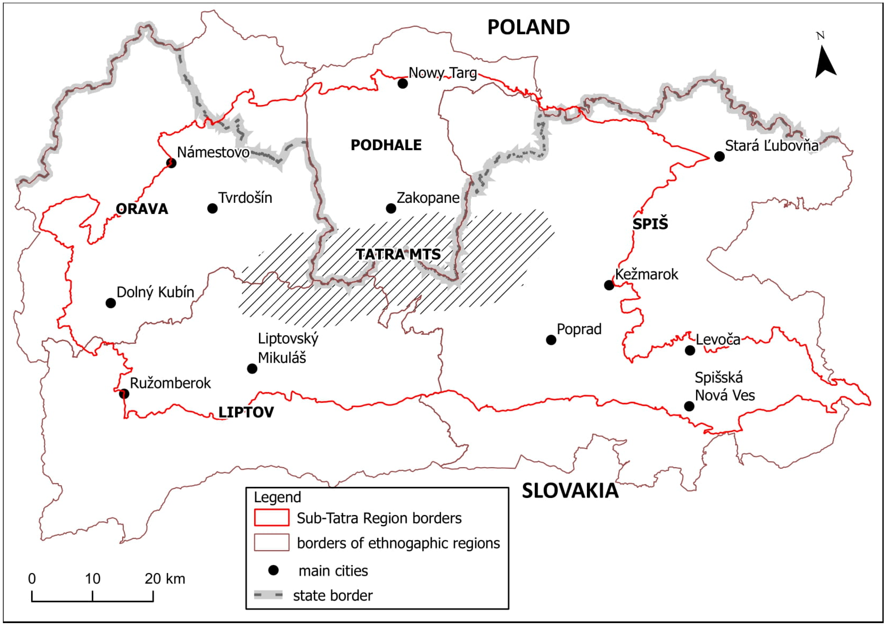
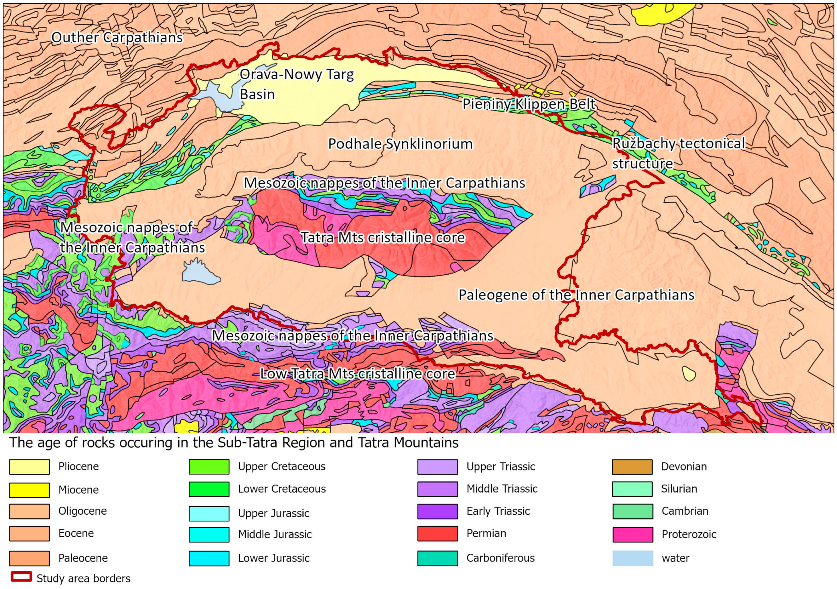
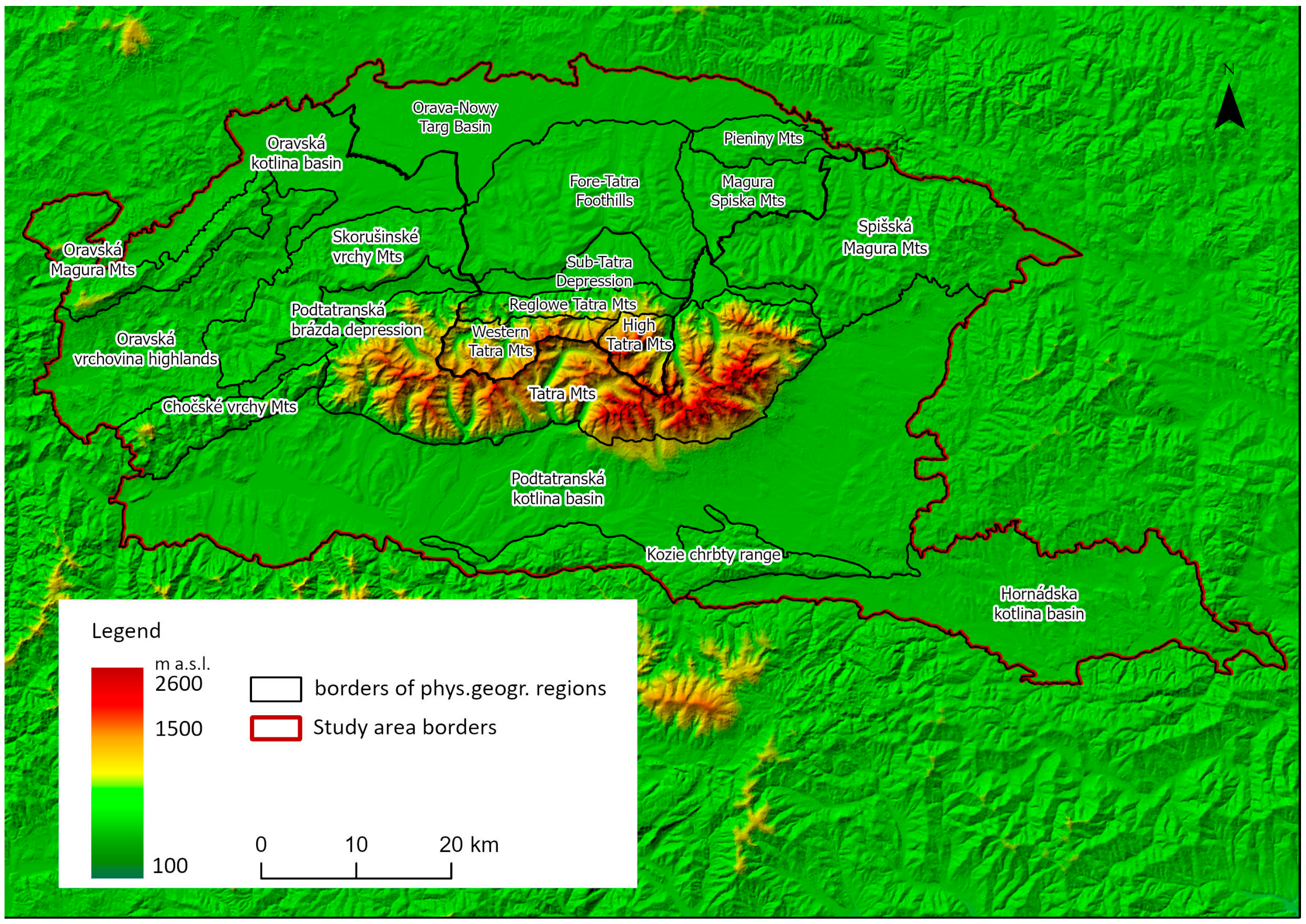
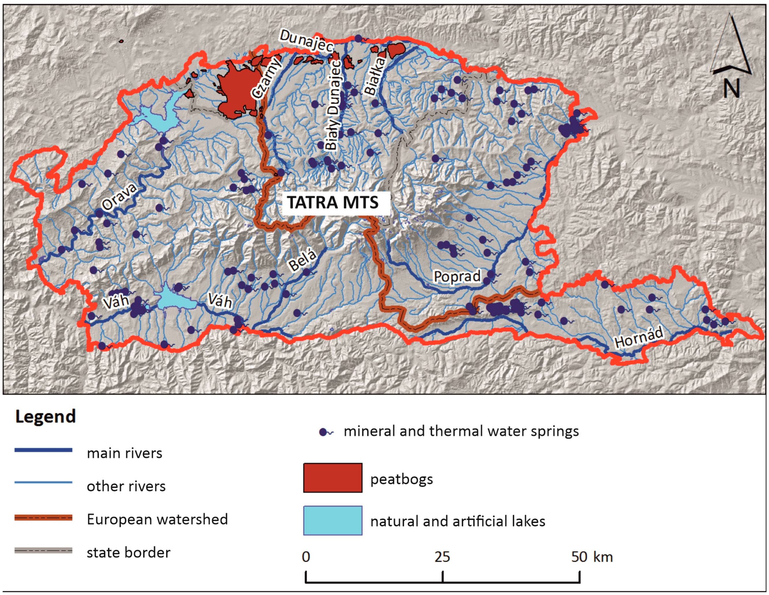
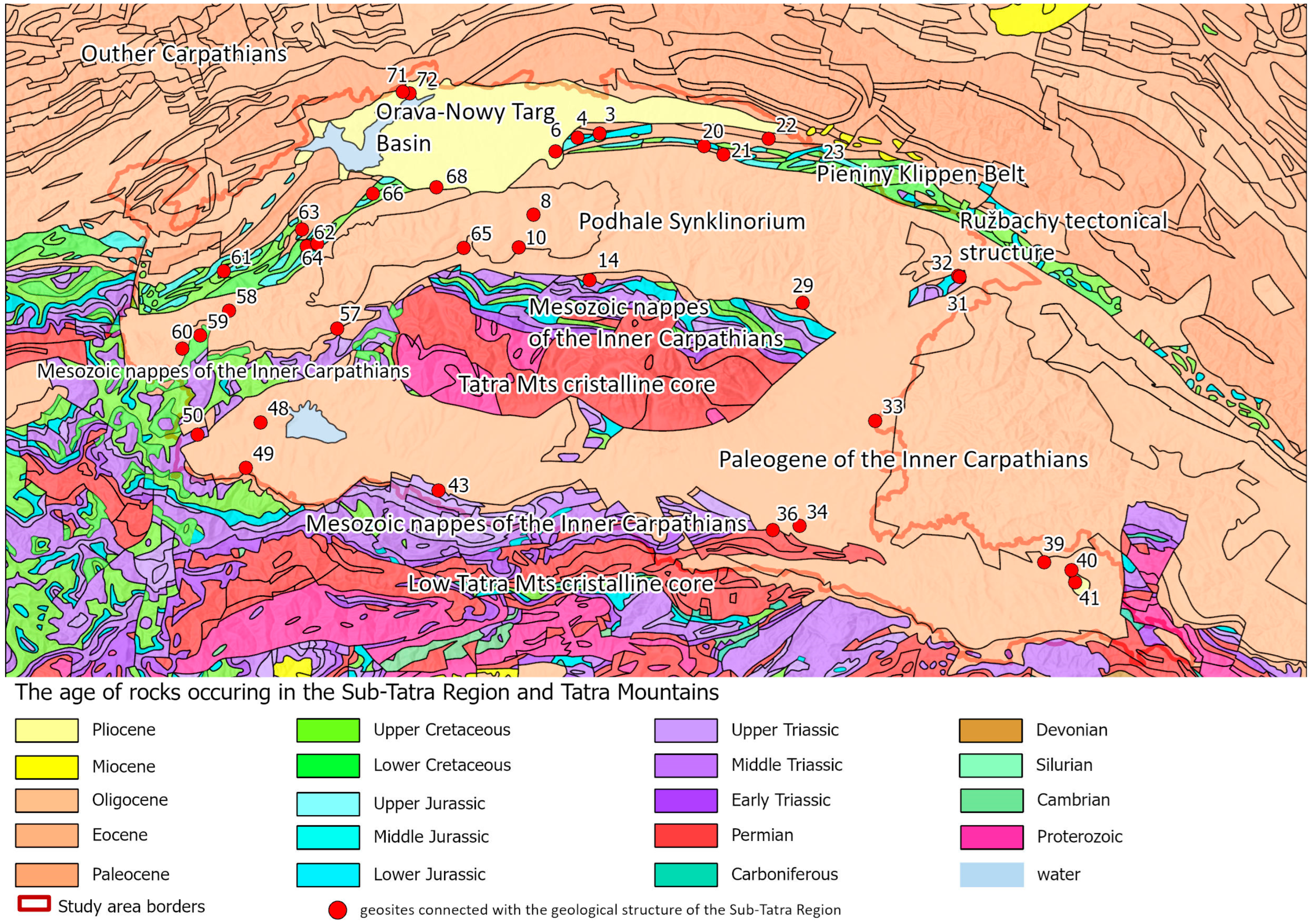
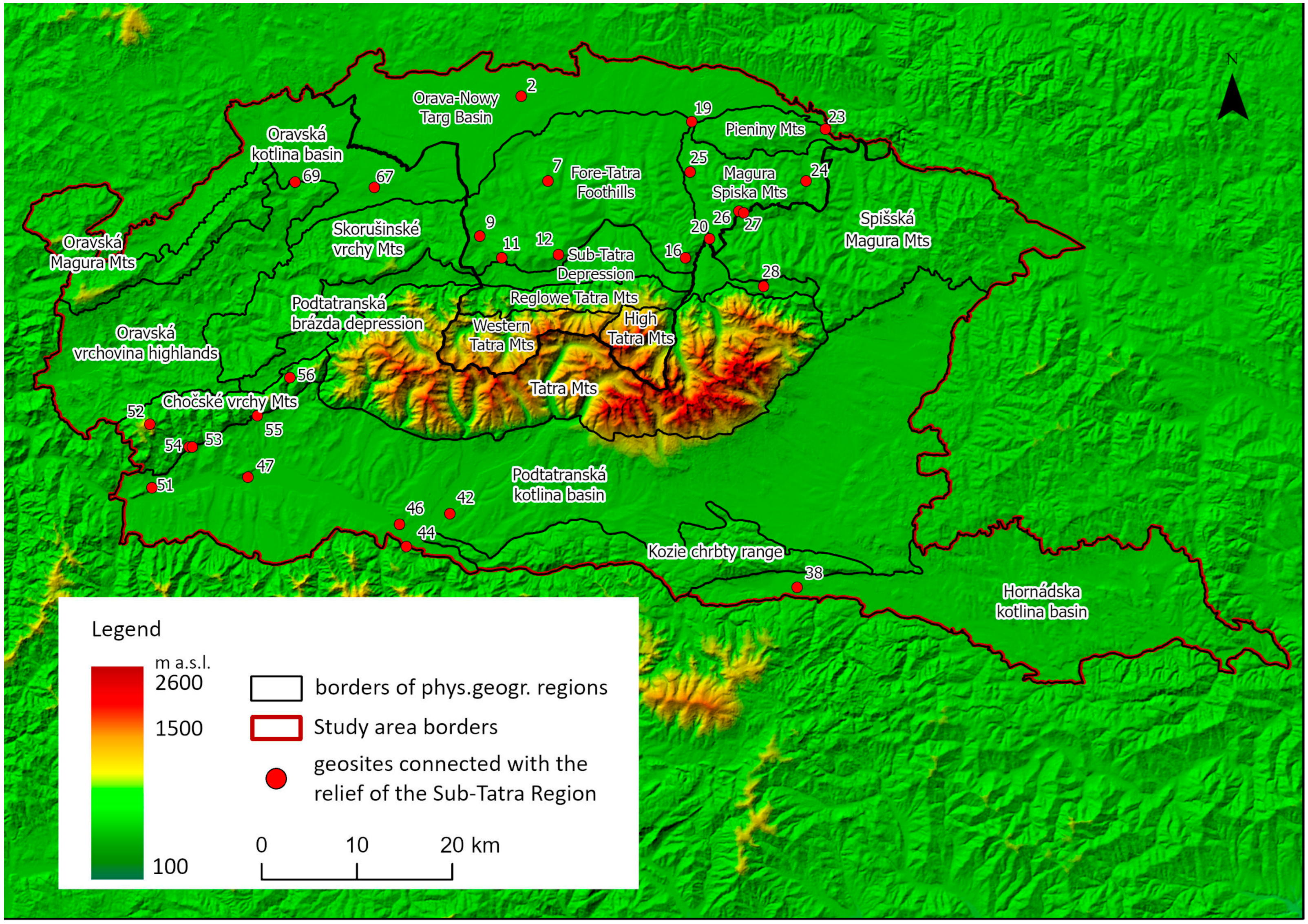
3. Study Area
4. Results
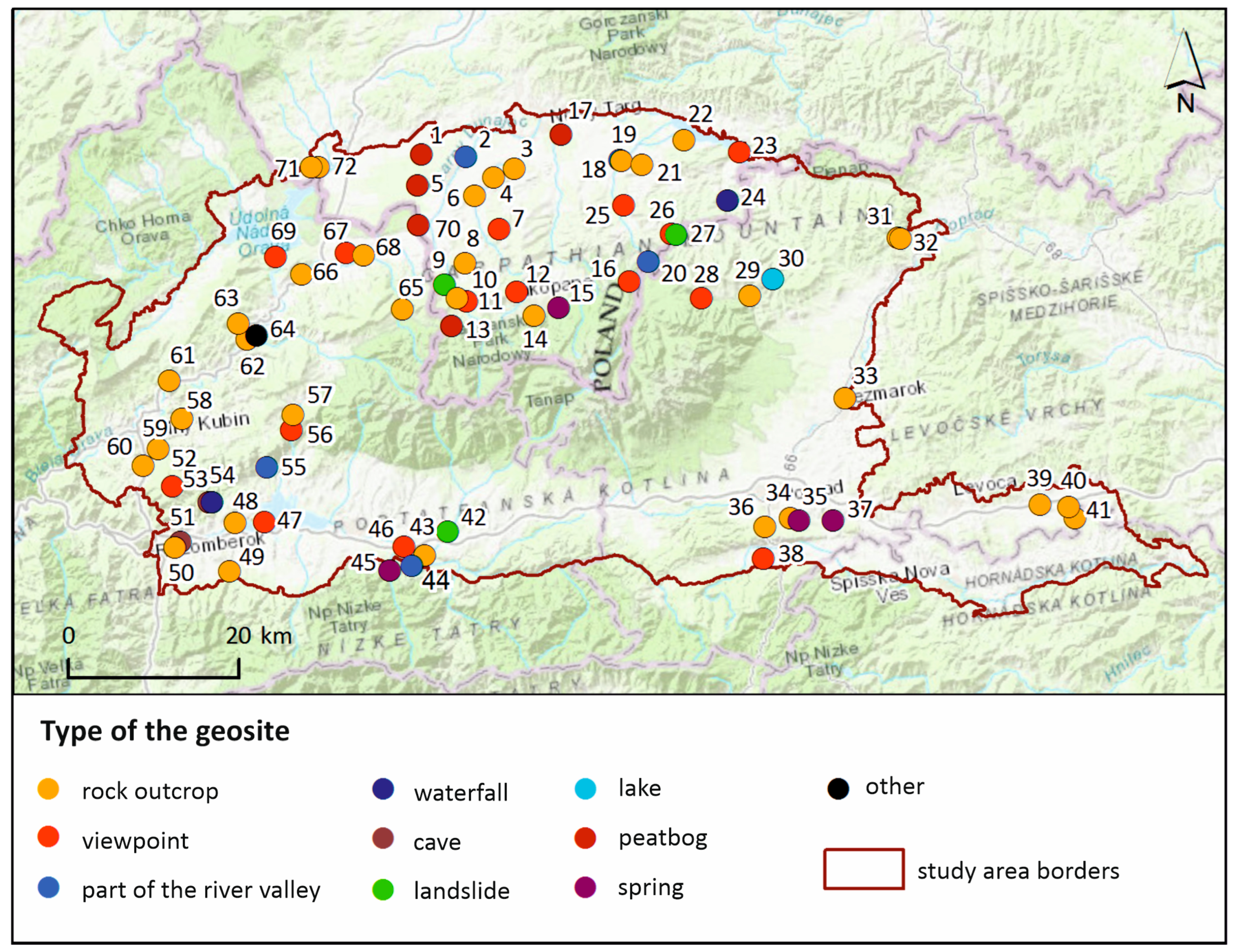
4.1. Inventory and Assessment of Geosites
4.2. Tourist Preferences
4.2.1. Age, Gender and Education Structure of Respondents
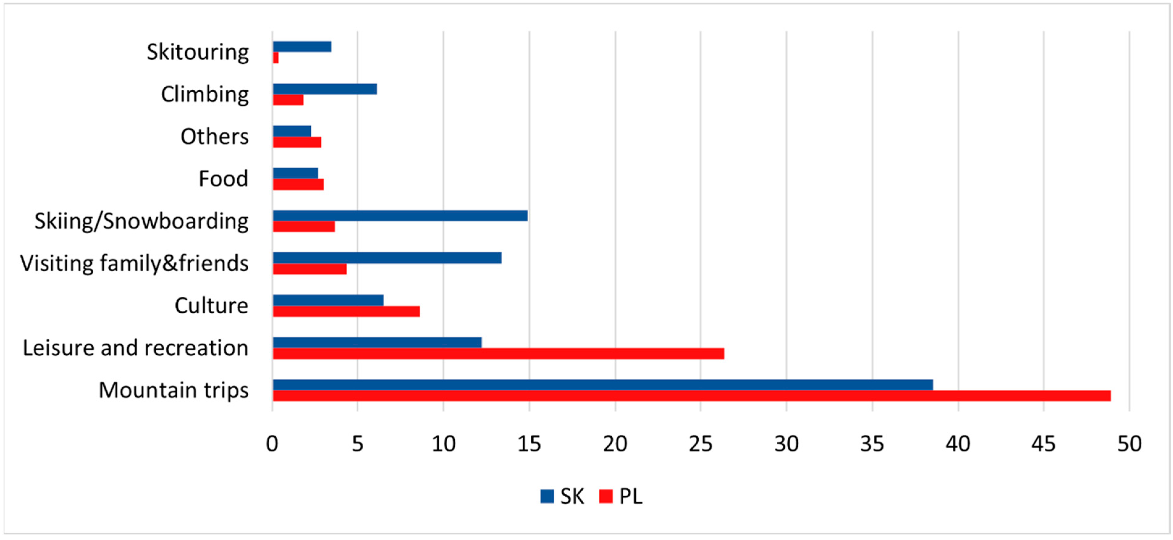
4.2.2. Frequency of Arrivals, Length of Stays and Destinations
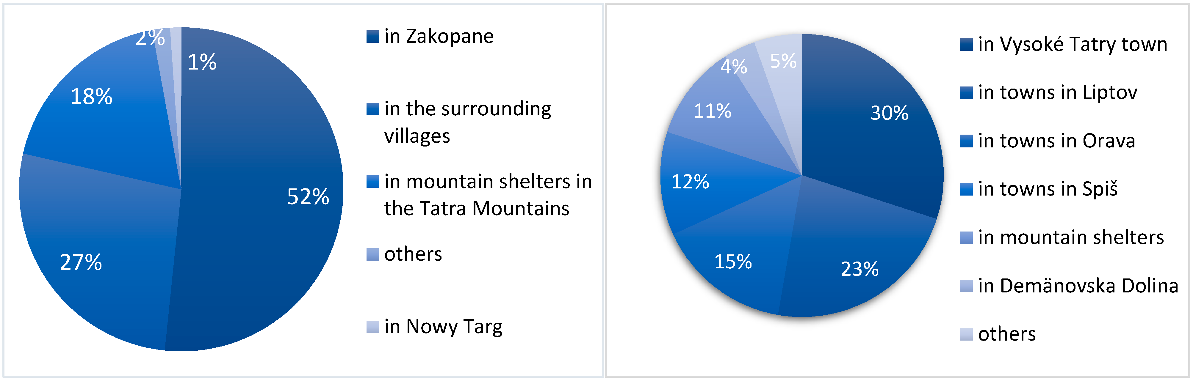
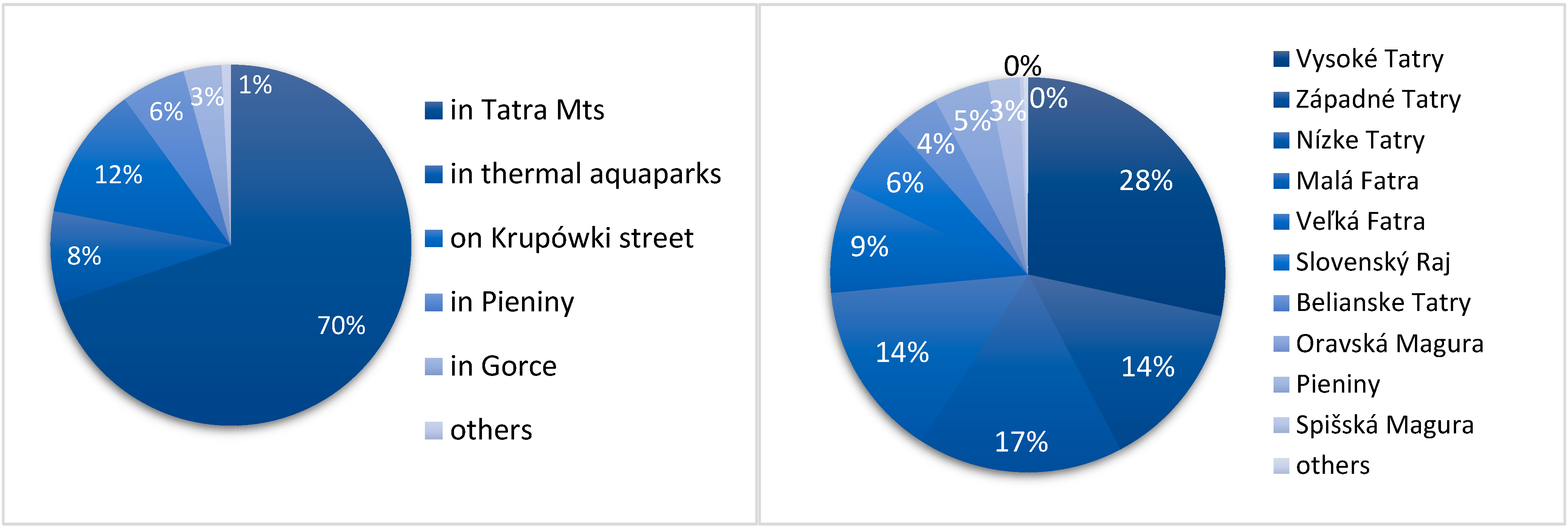
4.2.3. Destinations and Places of Stay in Sub-Tatra Region
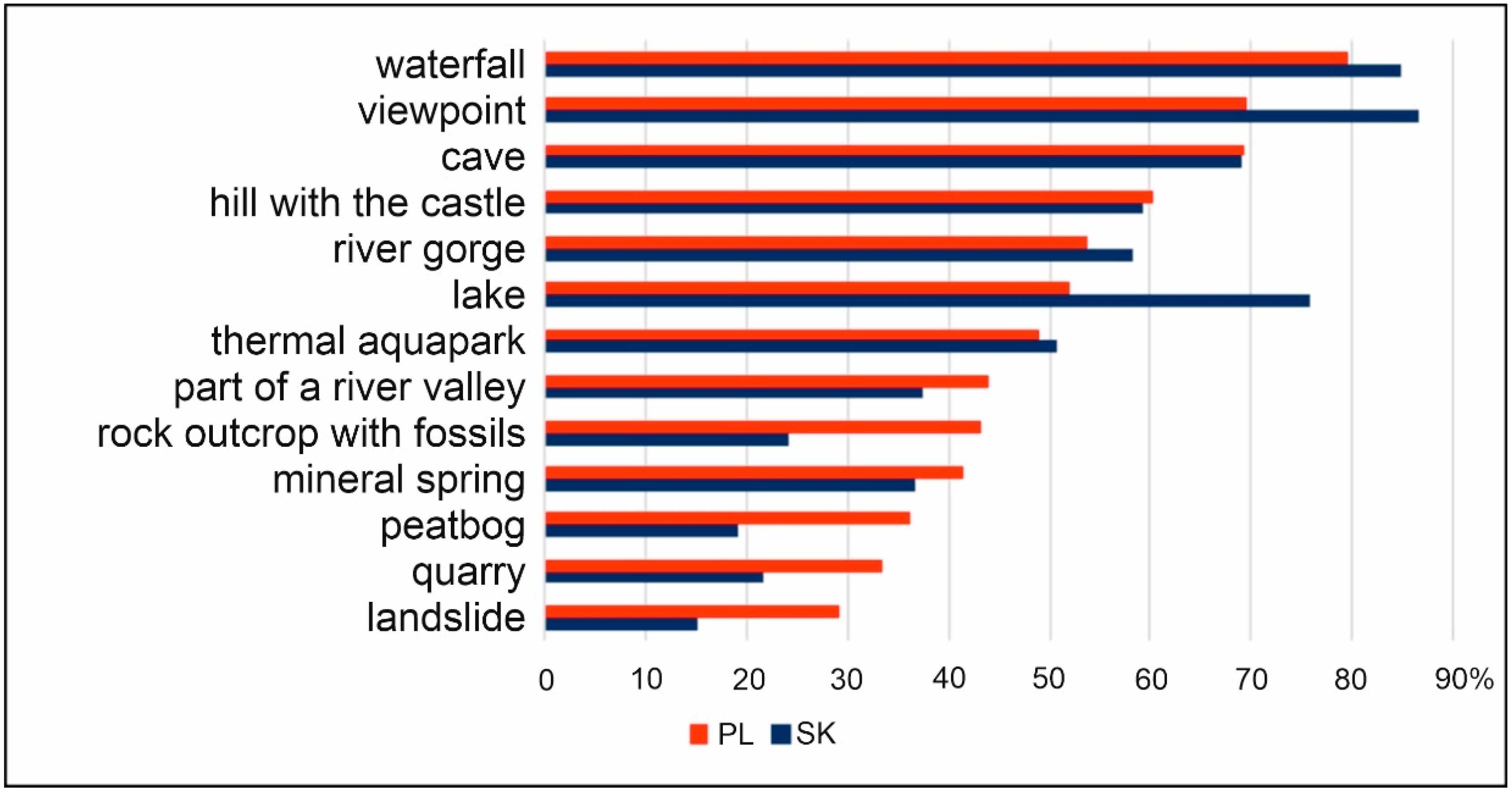
4.2.4. Tourist Preferences Regarding Particular Abiotic Natural Attractions
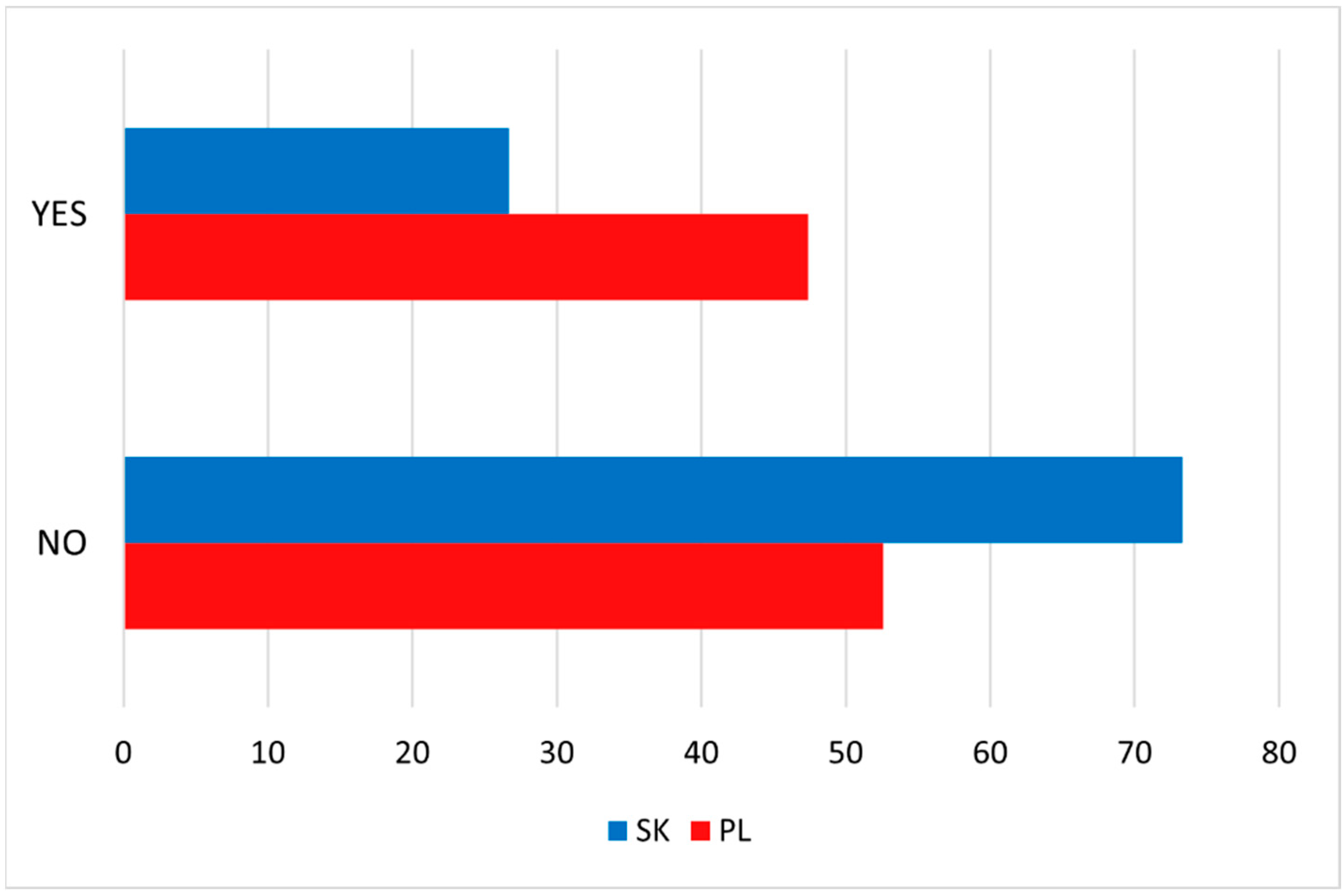
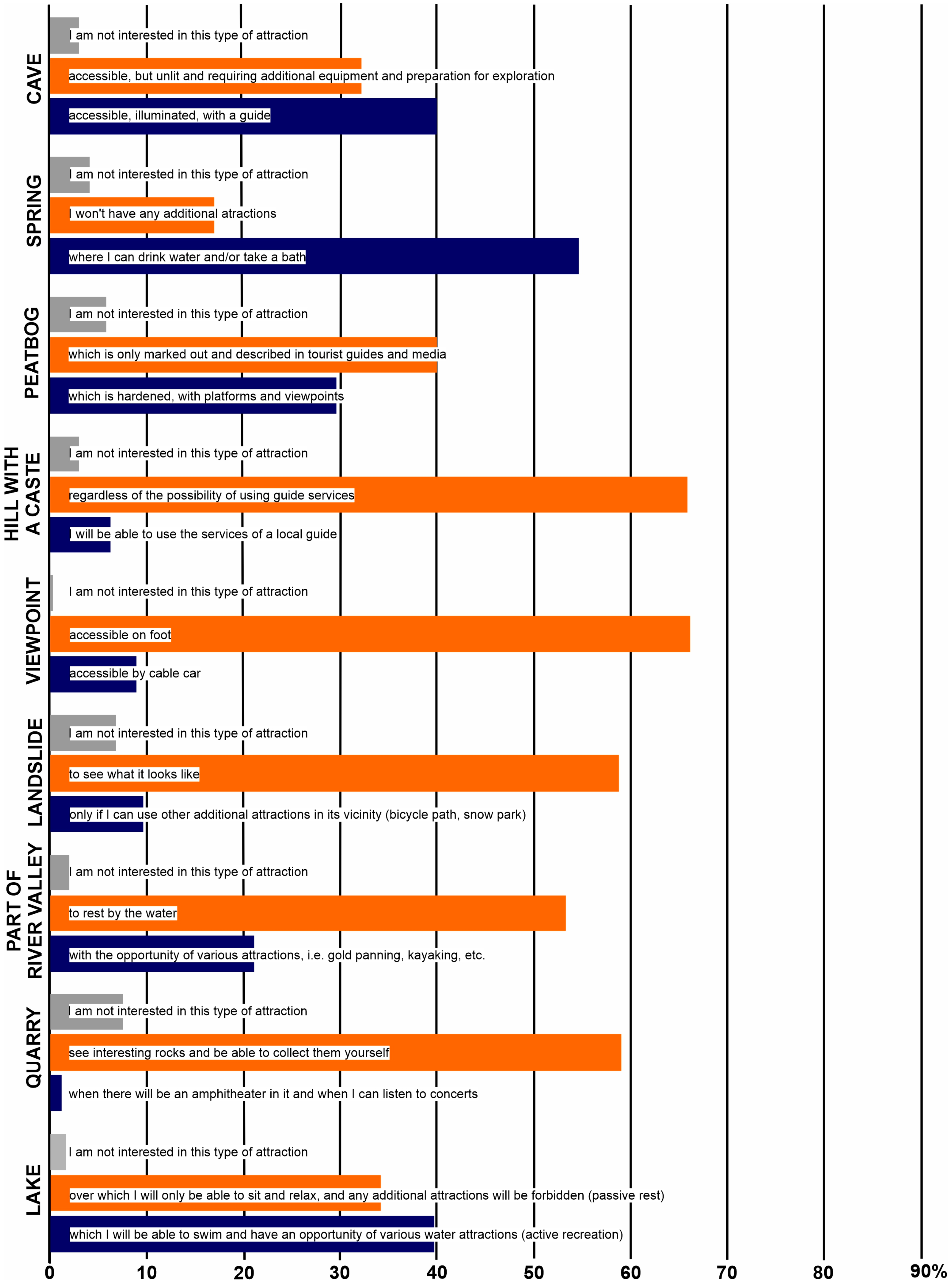
4.2.5. Respondent Expectations Regarding the Form of Geosite Development
5. Discussion
5.1. Assessment Results: General Comments
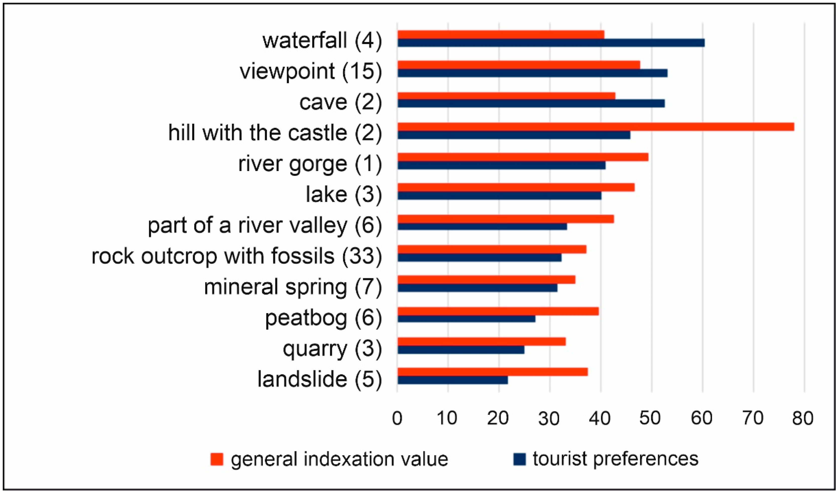
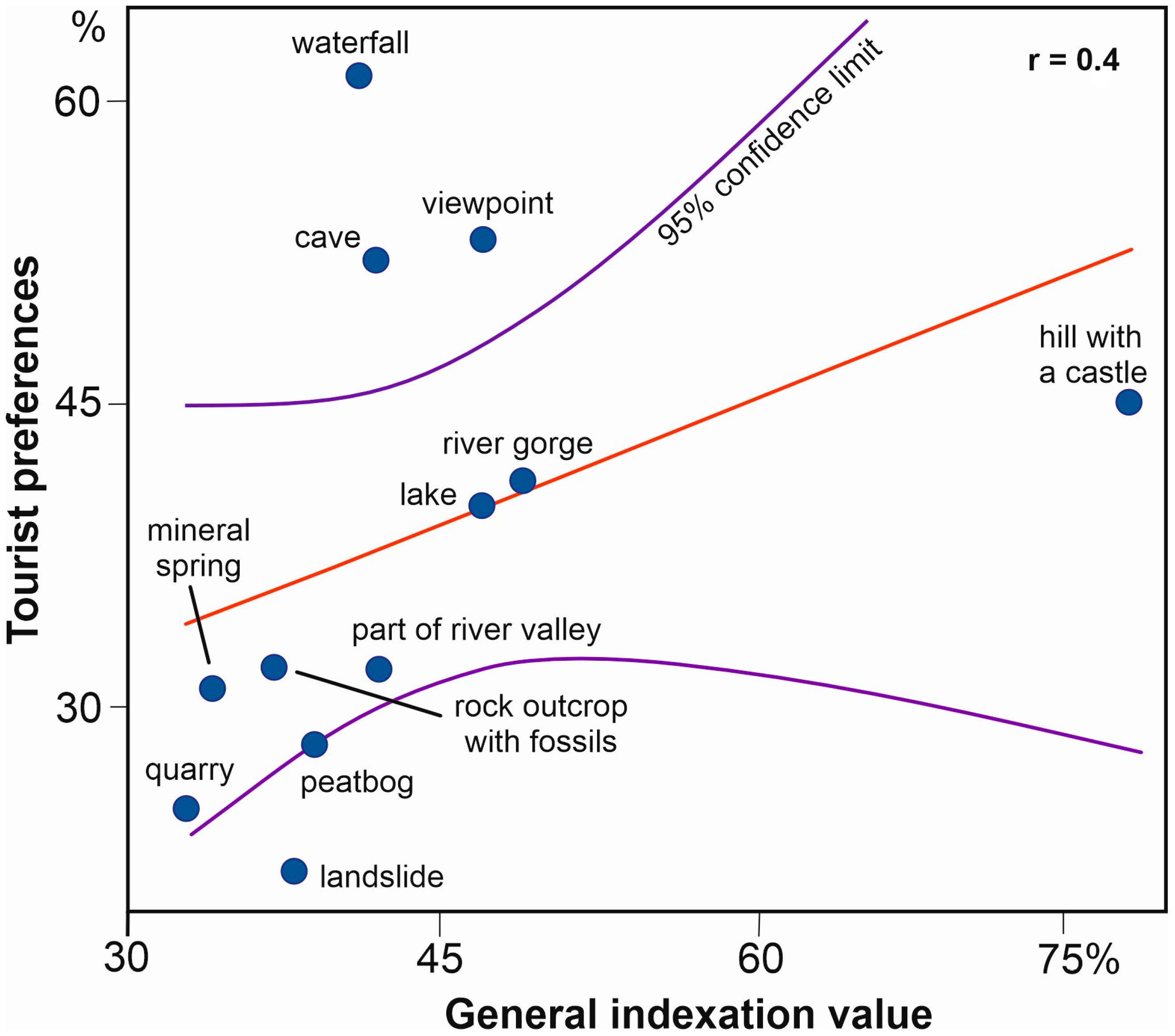
5.2. Expert and Final Assessment Results vs. Tourist Preferences
6. Conclusions
Supplementary Materials
Funding
Data Availability Statement
Acknowledgments
Conflicts of Interest
References
- Hose, T.A. Selling the story of Britain’s stone. Env. Interpret. 1995, 10, 16–17. [Google Scholar]
- De Waele, J.; Di Gregorio, F.; Pala, A. Karst Geomorphosites of Monte Albo (north-east Sardinia). Alp. Mediterr. Quat. 2005, 18, 145–153. [Google Scholar]
- Migoń, P. Development of karst phenomena for geotourism in the Moravian Karst (Czech Republic). Geotourism 2011, 36–37, 3–24. [Google Scholar]
- De Waele, J.; Di Gregorio, F.; Gasmi, N.; Melis, M.T.; Talbi, M. Geomorphosites of Tozeur region (south-west Tunisia). Alp. Mediterr. Quat. 2005, 18, 221–230. [Google Scholar]
- Zgłobicki, W.; Baran-Zgłobicka, B. Geomorphological Heritage as a Tourist Attraction. A Case Study in Lubelskie Province, SE Poland. Geoheritage 2013, 5, 137–149. [Google Scholar] [CrossRef]
- Tongkul, F. Waterfalls of Maliau Basin—Geoheritage of Sabah, Malaysian Borneo. Geoheritage 2016, 8, 235–245. [Google Scholar] [CrossRef]
- Garavaglia, V.; Pelfini, M.; Bollati, I. The influence of climate change on glacier geomorphosites: The case of two Italian glaciers (Miage Glacier, Forni Glacier) investigated through dendrochronology. Geomorphol. Reli. Process. Environ. 2010, 16, 153–164. [Google Scholar] [CrossRef]
- Bollati, I.; Leonelli, G.; Vezzola, L.; Pelfini, M. The role of Ecological Value in Geomorphosite assessment for the Debris-Covered Miage Glacier (Western Italian Alps) based on a review of 2.5 centuries of scientific study. Geoheritage 2015, 7, 119–135. [Google Scholar] [CrossRef]
- Reynard, E.; Buckingham, T.; Martin, S.; Regolini, G. Geoheritage, Geoconservation and Geotourism in Switzerland. In Landscapes and Landforms of Switzerland. World Geomorphological Landscapes; Reynard, E., Ed.; Springer: Cham, Switzerland, 2021. [Google Scholar] [CrossRef]
- Margielewski, W.; Alexandrowicz, Z. Diversity of landslide morphology as a part of geoconservation pattern in the Polish Carpathians. Polish Geol. Inst. Spec. Pap. 2004, 13, 65–72. [Google Scholar]
- Borgatti, L.; Tosatti, G. Slope Instability Processes Affecting the Pietra Di Bismantova Geosite (Northern Apennines, Italy). Geoheritage 2010, 2, 155–168. [Google Scholar] [CrossRef]
- Chrobak, A.; Cebulski, J. Landslides in the Polish Carpathians as the Potential Educational Geosites. Curr. Issues Tour. Res. 2014, 4, 38–49. [Google Scholar]
- Anifowose, A.Y.B.; Kolawole, F. Appraisal of the Geotourism Potentials of the Idanre Hills, Nigeria. Geoheritage 2014, 6, 193–203. [Google Scholar] [CrossRef]
- Waśkowska, A.; Golonka, J.; Witkowska, E. Klimkówka Lake in Beskid Niski—Geotouristic aspects. Geotourism 2014, 36, 3–14. [Google Scholar] [CrossRef]
- Hossain, I.; Nahar, M. Endangered geoheritage in Bangladesh: A case study of eocene sylhet limestone and adjoining areas, Jaflong, Sylhet. In Engineering Geology for Society and Territory-Volume 8; Springer: Cham, Switzerland, 2015; pp. 219–222. [Google Scholar] [CrossRef]
- Margiotta, S.; Sansò, P. Abandoned Quarries and Geotourism: An Opportunity for the Salento Quarry District (Apulia, Southern Italy). Geoheritage 2017, 9, 463–477. [Google Scholar] [CrossRef]
- Mikhailenko, A.V.; Nazarenko, O.V.; Ruban, D.A.; Zayats, P.P. Aesthetics-based classification of geological structures in outcrops for geotourism purposes: A tentative proposal. Geologos 2017, 23, 45–52. [Google Scholar] [CrossRef]
- Pérez-Umaña, D.; Quesada-Román, A.; De Jesús Rojas, J.C.; Zamorano-Orozco, J.J.; Dóniz-Páez, J.; Becerra-Ramírez, R. Comparative analysis of geomorphosites in volcanoes of Costa Rica, Mexico, and Spain. Geoheritage 2019, 11, 545–559. [Google Scholar] [CrossRef]
- Butorac, V.; Buzjak, N. Geodiversity and Landscape Services in the Region of Ogulinsko-Plašćanska Zavala, Croatia. Ekol. Bratislava 2020, 39, 130–144. [Google Scholar] [CrossRef]
- Ferreira, B.M.; de Lima, C.V.; Candeiro, C.R. dos A. Geodiversity geological and geomorphological of the municipality of Paraúna, central-southern Goiás state, Brazil. Soc. Nat. 2020, 32, 586–600. [Google Scholar] [CrossRef]
- Mucivuna, V.C.; Reynard, E.; Garcia, M.D.G.M. Geomorphosites assessment methods: Comparative analysis and typology. Geoheritage 2019, 11, 1799–1815. [Google Scholar] [CrossRef]
- Chrobak, A. Przegląd metod waloryzacji obiektów przyrody nieożywionej wykorzystywanych w geoturystyce. Pr. Kom. Geogr. Przem. Pol. Tow. Geogr. 2021, 35, 116–145. [Google Scholar] [CrossRef]
- Gray, M. Geodiversity: The origin and evolution of a paradigm. Geol. Soc. Spec. Publ. 2008, 300, 31–36. [Google Scholar] [CrossRef]
- Gray, M.; Gordon, J.E.; Brown, E.J. Geodiversity and the ecosystem approach: The contribution of geoscience in delivering integrated environmental management. Proc. Geol. Assoc. 2013, 124, 659–673. [Google Scholar] [CrossRef]
- Coratza, P.; Reynard, E.; Zwoliński, Z. Geodiversity and Geoheritage: Crossing Disciplines and Approaches. Geoheritage 2018, 10, 525–526. [Google Scholar] [CrossRef]
- Reynard, E.; Brilha, J. Geoheritage: Assessment, Protection, and Management; Elselvier: Amsterdam, The Netherlands, 2018; ISBN 9780128095423. [Google Scholar]
- Dixon, G. Geoconservation: An intrenational review and strategy for Tasmania. In Parks and Wildlife Service, Tasmania; Dixon, G., Ed.; Ocasional Paper 1996, No. 35; Department of Envirionment and Land Management: Hobart, Tasmania, 1996. [Google Scholar]
- Gray, M. GSSPs: The case for a third, internationally recognised, geoconservation network. Geoheritage 2011, 3, 83–88. [Google Scholar] [CrossRef]
- Perotti, L.; Bollati, I.M.; Viani, C.; Zanoletti, E.; Caironi, V.; Pelfini, M.; Giardino, M. Fieldtrips and virtual tours as geotourism resources: Examples from the Sesia Val Grande UNESCO Global Geopark (NW Italy). Resources 2020, 9, 63. [Google Scholar] [CrossRef]
- Kozak, M.; Decrop, A. Handbook of Tourist Behavior: Theory & Practice; Routledge: Business & Economics: New York, NY, USA, 2009; ISBN 978-0-415-99360-9. [Google Scholar]
- Yousaf, A.; Amin, I.; Santos, C.; Antonio, J. Tourist’s Motivations to Travel: A Theoretical Perspective on the Existing Literature. Tour. Hosp. Manag. 2018, 24, 197–211. [Google Scholar] [CrossRef]
- Maslow, A.H. A Theory of Human Motivation. Psychol. Rev. 1943, 50, 370–396. [Google Scholar] [CrossRef]
- Dann, G.M. Anomie, Ego-Enhancement and Tourism. Ann. Tour. Res. 1977, 4, 184–194. [Google Scholar] [CrossRef]
- Crompton, J.L. Motivations for Pleasure Vacation. Ann. Tour. Res. 1979, 6, 408–424. [Google Scholar] [CrossRef]
- Bashar, A.M.; Al-Haj, M.; Ahmad, P.M.S. An Analysis of Push and Pull Travel Motivations of Foreign Tourists to Jordan. Int. J. Bus. Manag. 2010, 5, 41–50. [Google Scholar] [CrossRef]
- Delekta, A.; Fidelus-Orzechowska, J.; Chrobak, A. Expert’s perceptions towards management of tourist traffic in protected areas based on the Tatra Mountains. J. Environ. Manag. Tour. 2020, 11, 443–459. [Google Scholar] [CrossRef]
- Gartner, W.C. Image Formation Process. J. Travel Tour. Mark. 1993, 2, 191–215. [Google Scholar] [CrossRef]
- Dann, G.M. Greenspeak: An Analysis of the Language of Eco-Tourism. Prog. Tour. Hosp. Res. 1996, 2, 247–259. [Google Scholar] [CrossRef]
- Baloglu, S.; Brinberg, D. Affective Images of Tourism Destinations. J. Travel Res. 1997, 35, 11–15. [Google Scholar] [CrossRef]
- Yoon, Y.; Uysal, M. An Examination of the Effects of Motivation and Satisfaction on Destination Loyalty: A Structural Model. Tour. Manag. 2005, 26, 45–56. [Google Scholar] [CrossRef]
- Kreps, D.M. A Course in Microeconomic Theory; Princeton University Press: New York, NY, USA, 1990. [Google Scholar]
- Niemczyk, A. Zachowania Konsumentów Na Rynku Turystycznym; Uniwersytet Ekonomiczny: Kraków, Poland, 2010; ISBN 978-83-7252-472-0. [Google Scholar]
- Rudnicki, L. Zachowania Konsumentów Na Rynku Turystycznym; Proksenia: Kraków, Poland, 2012; ISBN 978-83-60789-22-3. [Google Scholar]
- Dziedzic, E. Regionalne Badania Konsumentów Usług Turystycznych; Polska Organizacja Turystyczna: Warszawa, Poland, 2010. [Google Scholar]
- Rogowski, M. Preferencje Turystów w Polskich Karkonoszach Jako Podstawa Tworzenia Produktu Turystycznego Obszaru. Rozpr. Nauk. Akad. Wych. Fiz. we Wrocławiu 2015, 50, 152–163. [Google Scholar]
- Boley, B.B.; Nickerson, N.P.; Bosak, K. Measuring Geotourism Developing and Testing the Geotraveler Tendency Scale (GTS). J. Travel Res. 2011, 50, 567–578. [Google Scholar] [CrossRef]
- Migoń, P. Geoturystyka; Wydawnictwo Naukowe PWN: Warszawa, Poland, 2012. [Google Scholar]
- Štrba, Ľ. Analysis of Criteria Affecting Geosite Visits by General Public: A Case of Slovak (Geo)Tourists. Geoheritage 2018, 11, 291–300. [Google Scholar] [CrossRef]
- Cengiz, C.; Şahin, Ş.; Cengiz, B.; Bahar, M.B.; Keçecioğlu Dağlı, P. Evaluation of the Visitor Understanding of Coastal Geotourism and Geoheritage Potential Based on Sustainable Regional Development in Western Black Sea Region, Turkey. Sustainability 2021, 12, 11812. [Google Scholar] [CrossRef]
- Du Preez, E.A. The contribution of geological features to visitor experiences: Comparison between two geotourism attractions in South Africa. Geoj. Tour. Geosites 2019, 26, 1006–1020. [Google Scholar] [CrossRef]
- Štrba, L.; Kršák, B.; Sidor, C. Some comments to geosite assessment, visitors, and geotourism sustainability. Sustainability 2018, 10, 2589. [Google Scholar] [CrossRef]
- Pereira, P.; Pereira, D. Methodological guidelines for geomorphosite assessment. Géomorphologie Reli. Process. Environ. 2010, 2, 215–222. [Google Scholar] [CrossRef]
- Fassoulas, C.; Mouriki, D.; Dimitriou-Nikolakis, P.; Iliopoulos, G. Quantitative Assessment of Geotopes as an Effective Tool for Geoheritage Management. Geoheritage 2012, 4, 177–193. [Google Scholar] [CrossRef]
- Warszyńska, J. Waloryzacja miejscowości z punktu widzenia atrakcyjności turystycznej (zarys metody). Zesz. Nauk. Uniw. Jagiellońskiego. Pr. Geogr. 1970, 249, 103–114. [Google Scholar]
- Denzin, N.K. The Research Act; Aldine: Chicago, IL, USA, 1970. [Google Scholar]
- Flick, U. Jakość w Badaniach Jakościowych; Wydawnictwo Naukowe PWN: Warszawa, Poland, 2011. [Google Scholar]
- Solon, J.; Borzyszkowski, J.; Bidłasik, M.; Richling, A.; Badora, K.; Balon, J.; Brzezińska-Wójcik, T.; Chabudziński, Ł.; Dobrowolski, R.; Grzegorczyk, I.; et al. Physico-geographical mesoregions of Poland: Verification and adjustment of boundaries on the basis of contemporary spatial data. Geogr. Pol. 2018, 91, 143–170. [Google Scholar] [CrossRef]
- Urbánek, J.; Beták, J.; Jakál, J.; Lacika, J.; Novotný, J. Regional geomorphological division of Slovakia: Old problem in new perspectives in Slovak Geography at the Beginning of the 21st Century. Geogr. Slovaca 2009, 26, 237–259. [Google Scholar]
- Gołąb, J. Flisz Podhala Na Zachód Od Białego Dunajca; Archiwum Państwowego Instytutu Geologicznego; Oddział Karpacki: Kraków, Poland, 1954. [Google Scholar]
- Watycha, L. Uwagi o Geologii Fliszu Podhalańskiego We Wschodniej Części Podhala. Przegląd Geol. 1959, 7, 350–356. [Google Scholar]
- Janočko, J.; Jacko, S. Marginal and deep sea deposits of Central Carpathian Paleogene Basin, Spisska Magura Region, Slovakia: Implication for basin history. Slovak Gelogical Mag. 1999, 4, 281–292. [Google Scholar]
- Biely, A.; Bezák, V.; Elečko, M.; Gross, P.; Kaličiak, M.; Konečný, V.; Lexa, J.; Mello, J.; Nemčok, J.; Potfaj, M.; et al. Geologicka mapa Slovenska, 1:500,000; Vydavateľstvo Dionýza Štúra: Bratislava, Slovakia, 1996. [Google Scholar]
- Jurewicz, E. Geodynamic evolution of the Tatra Mts. and the Pieniny Klippen Belt (Western Carpathians): Problems and comments. Acta Geol. Pol. 2005, 55, 295–338. [Google Scholar]
- Plašienka, D. Development of basement-involved fold and thrust structures exemplified by the Tatric-Fatric-Veporic nappe system of the Western Carpathians (Slovakia). Geodin. Acta 2003, 16, 21–38. [Google Scholar] [CrossRef]
- Żelaźniewicz, A.; Aleksandrowski, P.; Buła, Z.; Karnkowski, P.H.; Konon, A.; Oszczypko, N.; Ślączka, A.; Żaba, J.; Żytko, K. Regionalizacja Tektoniczna Polski; Komitet Nauk Geologicznych PAN: Wrocław, Poland, 2011. [Google Scholar]
- Birkenmajer, K. Przewodnik Geologiczny po Pienińskim Pasie Skałkowym; Wydawnictwa Geologiczne: Warszawa, Poland, 1979. [Google Scholar]
- Birkenmajer, K. Jurassic and Cretaceous lithostratigraphic units of the Pieniny Klippen Belt, Carpathinas. Stud. Geol. Pol. 1977, 45, 1–159. [Google Scholar]
- Plašienka, D.; Mikuš, V. Geologická stavba pieninského a šarišského úseku bradlového pásma medzi Litmanovou a Drienicou na východnom Slovensku. Miner. Slovaca 2010, 42, 155–178. [Google Scholar]
- Krobicki, M.; Golonka, J. Geological history of the Pieniny Klippen Belt and Middle Jurassic black shales as one of the oldest deposits of this region—Stratigraphical position and palaeoenvironmental significance. Geoturystyka 2008, 13, 3–18. [Google Scholar] [CrossRef]
- Łoziński, M.; Wysocka, A.; Ludwiniak, M. Neogene terrestrial sedimentary environments of the Orava-Nowy Targ Basin: A case study of the Oravica River section near Čimhová, Slovakia. Geol. Q. 2015, 59, 21–34. [Google Scholar] [CrossRef]
- Watycha, L. Badania czwartorzędu i neogenu w kotlinie orawsko-nowotarskiej. Cz. III-Neogen w kotlinie orawsko-nowotarskiej. Arch. Inst. Geol. Warszawa 1971, 20, 575–588. [Google Scholar]
- Watycha, L. Neogen niecki orawsko-nowotarskiej. Geol. Q. 1976, 20, 575–587. [Google Scholar]
- Birkenmajer, K. Forma geologiczna andezytów Wżaru. Acta Geol. Pol. 1962, XII, 201–213. [Google Scholar]
- Birkenmajer, K.; Pécskay, Z. K-Ar dating of the Miocene andesite intrusions, Pieniny Mts, West Carpathians, Poland: A supplement. Stud. Geol. Pol. 2000, 117, 7–25. [Google Scholar]
- Bac-Moszaszwili, M.; Jurewicz, E. Wycieczki Geologiczne W Tatry; TPN: Zakopane, Poland, 2010. [Google Scholar]
- Lexa, J.; Bezák, M.; Elečko, M.; Mello, J.; Polák, M.; Potfaj, M.; Vozár, J. Geological Map of Western Carpathians and Adjacent Areas, 1:500,000; Geological Survey of Slovak Republic: Bratislava, Slovakia, 2000. [Google Scholar]
- Zasadni, J.; Kłapyta, P. The Tatra Mountains during the Last Glacial Maximum. J. Maps 2014, 10, 440–456. [Google Scholar] [CrossRef]
- Zasadni, J.; Kłapyta, P.; Świąder, A. Lodowce maksimum ostatniego zlodowacenia i osady starszych zlodowaceń. In Atlas Tatr: Przyroda Nieożywiona; Dąbrowska, K., Guzik, M., Eds.; TPN: Zakopane, Poland, 2015. [Google Scholar]
- Gorczyca, E.; Krzemień, K.; Łyp, M. Contemprorary trends in the Białka river channel development in the Western Carpathians. Geogr. Pol. 2011, 84, 39–53. [Google Scholar] [CrossRef]
- Wyżga, B.; Zawiejska, J. Large wood storage in channelized and unmanaged sections of the Czarny Dunajec River, Polish Carpathians: Implications for the restoration of mountain rivers. Folia Geogr. Ser. Geogr. 2010, 41, 5–34. [Google Scholar]
- Kukulak, J. Weathering of gravels in the Czarny Dunajec alluvial cone in Podhale, Polish Carpathians. Quaest. Geogr. 2001, 21, 69–78. [Google Scholar]
- Poprawa, D.; Rączkowski, W. Osuwiska Karpat. Przegląd Geol. 2003, 51, 685–692. [Google Scholar]
- Kukulak, J.; Augustowski, K. Landslides on river banks in the western part of podhale (Central Carpathians, Poland). Geol. Q. 2016, 60, 561–571. [Google Scholar] [CrossRef]
- Hochmuth, Z. Krasové územia a jaskyne Slovenska. Geogr. Cassoviensis 2008, 2, 5–210. [Google Scholar]
- Lehotský, M. Kotlinový kras—Geomorfologické pomery a aspekt exhumácie (príklad Hybského Krasu). Geogr. Časopis 2001, 53, 111–126. [Google Scholar]
- Krzemień, K. The Czarny Dunajec River, Poland, as an example of human-induced development tendencies in a mountain river channel. Landf. Anal. 2003, 4, 57–64. [Google Scholar]
- Malgot, J.; Baliak, F. The influence of human activity on the development of landslides in Slovakia. Geogr. Časopis 2002, 54, 21–38. [Google Scholar]
- Balon, J.; Jodłowski, M. Regionalizacja fizycznogeograficzna Karpat Zachodnich—Studium metodologiczne. In Struktura środowiska Przyrodniczego a Fizjonomia Krajobrazu; Ziaja, W., Jodłowski, M., Eds.; Instytut Geografii i Gospodarki Przestrzennej Uniwersytetu Jagiellońskiego: Kraków, Poland, 2014; pp. 85–106. [Google Scholar]
- Balon, J.; Jodłowski, M.; Krąż, P. Regiony fizycznogeograficzne Karpat Zachodnich. In Atlas Tatr—Przyroda Nieożywiona; Dąbrowska, K., Guzik, M., Eds.; TPN: Zakopane, Poland, 2015. [Google Scholar]
- Kondracki, J. Karpaty; Państwowe Wydawnictwo Naukowe: Warszawa, Poland, 1978. [Google Scholar]
- Kondracki, J. Geografia Regionalna Polski; Wydawnictwo Naukowe PWN: Warszawa, Poland, 2011. [Google Scholar]
- Mazúr, E.; Lukniš, M. Geomorfologické jednotky. In Atlas Slovenskej Socjalistickej Republiky; Mazúr, E., Ed.; Slovenská Akademia vied, Slovenský Úrad Geodézie a Kartografie: Bratislava, Slovakia, 1980. [Google Scholar]
- Kidová, A.; Lehotský, M. Časovo-priestorová variabilita morfológie divočiaceho a migrujúceho vodného toku Belá. Geogr. Časopis 2012, 64, 311–333. [Google Scholar]
- Kidová, A.; Lehotský, M.; Rusnák, M. Morfologické zmeny a manažment divočiacomigrujúceho vodného toku Belá. Geomorphol. Slovaca Bohem. 2016, 16, 7–59. [Google Scholar]
- Małecka, D. Hydrogeologia Podhala. Pr. Hydrogeol. Ser. Spec. 1981, 14, 3–187. [Google Scholar]
- Alexandrowicz, W.P. Molluscan assemblages of recent calcareous tufas in the Podhale Basin and Pieniny Mts (S. Poland). Folia Malacol. 2010, 18, 99–112. [Google Scholar] [CrossRef]
- Ložek, V. Travertines. Pr. Inst. Geol. 1961, 34, 81–86. [Google Scholar]
- Gradziński, M.; Wróblewski, W.; Bella, P. Cenozoic freshwater carbonates of the Central Carpathians (Slovakia): Facies, environments, hydrological control and depositional history. In Guide to Field Trip B7, 31st IAS Meeting of Sedimentology; Gradziński, M., Wróblewski, W., Bella, P., Eds.; AGH: Kraków, Poland, 2015; pp. 217–245. ISBN 9788394230401. [Google Scholar]
- Gradziński, M. Origin of a unique tree-mould type cave in travertine based on examples from the village of Lúčky (Liptov, Slovakia). Slov. Kras 2008, 46, 69–75. [Google Scholar]
- Gradziński, M.; Duliński, M.; Hercman, H.; Stworzewicz, E.; Holubek, P.; Rajnoga, P.; Wróblewski, W.; Kováčová, M. Facies and age of travertines From Spiš and Liptov Regions (Slovakia)—Preliminary results. Slov. Kras 2008, 46, 31–40. [Google Scholar]
- Chowaniec, J.; Witek, K. Mapa Hydrogeologiczna Polski w Skali 1:50 000; Czarny Dunajec, Poland, 1997; Arkusz 1048; Państwowy Instytut Geologiczny: Warszawa, Poland.
- Chowaniec, J.; Witek, K. Mapa Hydrogeologiczna Polski w Skali 1:50 000; Rabka, Poland, 1997; Arkusz 1032; Państwowy Instytut Geologiczny: Warszawa, Poland.
- Skąpski, K.; Garbacz, K. Mapa Hydrogeologiczna Polski w Skali 1:50 000; Zawoja, Poland, 1997; Arkusz 1031; Państwowy Instytut Geologiczny: Warszawa, Poland.
- Małecka, D.; Humnicki, W.; Barczyk, G. Mapa Hydrogeologiczna Polski w Skali 1:50 000; Tatry Zachodnie, Slovakia, 2002; Arkusz 1060; Państwowy Instytut Geologiczny: Warszawa, Poland.
- Małecka, D.; Humnicki, W.; Małecki, J. Mapa Hydrogeologiczna Polski w Skali 1:50 000; Tatry Wysokie, Slovakia, 2002; Arkusz 1061; Państwowy Instytut Geologiczny: Warszawa, Poland.
- Turbek, J. Hydrologicka mapa Slovenska. In Atlas SSR; Mazúr, E., Ed.; Slovenská Akademia Vied, Slovenský Úrad Geodézie a Kartografie: Bratislava, Slovakia, 1980. [Google Scholar]
- Łajczak, A. Warunki rozwoju i rozmieszczenie torfowisk w kotlinie orawsko-nowotarskiej. Prz. Geol. 2009, 57, 694–702. [Google Scholar]
- Łajczak, A. Torfowiska Kotliny Orawsko-Nowotarskiej. Rozwój, Antropogeniczna Degradacja, Renaturyzacja i Wybrane Problemy Ochrony; Instytut Botaniki im. W. Szafera, Polska Akademia Nauk: Kraków, Poland, 2006. [Google Scholar]
- Lipka, K. Ocena Aktualnego Stanu Wartości Przyrodniczych Torfowisk oraz Terenów Przyległych z Określeniem Możliwości Ograniczonego, Kontrolowanego Pozyskania Mchów Torfowców na Obszarze Gmin: Lipnica Wielka, Jabłonka, Czarny Dunajec, Nowy Targ-Miasto i Gmina; Firma Specjalistyczna PEAT-POL: Kraków, Poland, 1999. [Google Scholar]
- Lipka, K.; Zając, E. Peatbogs in the Orawa-Nowy Targ Basin. Acta Hortic. Regiotect. Mimoriadne Cislo 2003, 6, 119–122. [Google Scholar]
- Chrobak, A.; Bąk, K. Poznawczo-Edukacyjne Aspekty Atrakcji Geoturystycznych Podtatrza; Wydawnictwo Naukowe UP: Kraków, Poland, 2019. [Google Scholar]
- Chrobak, A. Analiza i Ocena Potencjału Geoturystycznego Podtatrza. Ph.D. Thesis, Uniwersytet Pedagogiczny w Krakowie, Instytut Geografii, Kraków, Poland, 2018. [Google Scholar]
- Chrobak, A. Valorisation and categorisation of the geosites in the Podtatrze area (Southern Poland). Geotourism 2016, 46–47, 3–26. [Google Scholar] [CrossRef]
- Cochran, W.G. Sampling Techniques; Wiley: New York, NY, USA, 1977. [Google Scholar]
- Zwoliński, Z. The routine of landform geodiversity map design for the Polish Carpathian Mts. Landf. Anal. 2009, 11, 77–85. [Google Scholar]
- Zwoliński, Z.; Stachowiak, J. Geodiversity map of the Tatra National Park for geotourism. Quaest. Geogr. 2012, 31, 99–107. [Google Scholar] [CrossRef]
- Mizgajski, A. Odniesienie georóżnorodności do wybranych pojęć w naukach o środowisku. In Funkcjonowanie Geoekosystemów w Zróżnicowanych Warunkach Morfoklimatycznych. Monitoring, Ochrona, Edukacja; Karczewski, A., Zwoliński, Z., Eds.; Bogucki Wydawnictwo Naukowe: Poznań, Poland, 2001; pp. 369–375. [Google Scholar]
- Chrobak, A.; Novotný, J.; Struś, P. Geodiversity assessment as a first step in designating areas of geotourism potential. Case study: Western Carpathians. Front. Earth Sci. 2021, 9, 752669. [Google Scholar] [CrossRef]
- Najwer, A.; Zwoliński, Z. Semantyka i metodyka oceny georóżnorodności—Przegląd i propozycja badawcza. Landf. Anal. 2014, 26, 115–127. [Google Scholar] [CrossRef]
- Jankowski, P.; Najwer, A.; Zwoliński, Z.; Niesterowicz, J. Geodiversity Assessment with Crowdsourced Data and Spatial Multicriteria Analysis. Int. J. Geo-Inf. 2020, 9, 716. [Google Scholar] [CrossRef]
- Štrba, L.; Rybár, P.; Baláž, B.; Molokáč, M.; Hvizdák, L.; Kršák, B.; Lukáč, M.; Muchová, L.; Tometzová, D.; Ferenčíková, J. Geosite assessments: Comparison of methods and results. Curr. Issues Tour. 2014, 18, 496–510. [Google Scholar] [CrossRef]
- Santos, D.S.; Mansur, K.L.; Seoane, J.C.S.; Mucivuna, V.C.; Reynard, E. Methodological proposal for the inventory and assessment of geomorphosites: An integrated approach focused on territorial management and geoconservation. Environ. Manag. 2020, 66, 476–497. [Google Scholar] [CrossRef] [PubMed]
- Alexandrowicz, Z.; Kućmierz, A.; Urban, J.; Otęska-Budzyn, J. Waloryzacja Przyrody Nieożywionej Obszarów i Obiektów Chronionych w Polsce; Wydawnictwo Państwowego Instytutu Geologicznego: Warszawa, Poland, 1992. [Google Scholar]
- Serrano, E.; González-Trueba, J.J. Assessment of geomorphosites in natural protected areas: The Picos de Europa National Park (Spain). Géomorphologie Reli. Process. Environ. 2005, 11, 197–208. [Google Scholar] [CrossRef]
- Reynard, E.; Fontana, G.; Kozlik, L.; Scapozza, C. A method for assessing “scientific” and “additional values” of geomorphosites. Geogr. Helv. 2007, 62, 148–158. [Google Scholar] [CrossRef]
- Panizza, V.; Mennella, M. Assessing geomorphosites used for rock climbing. The example of Monteleone Rocca Doria (Sardinia, Italy). Geogr. Helv. 2007, 62, 181–191. [Google Scholar] [CrossRef]
- Koźma, J. Opracowanie Zasad Identyfikacji i Waloryzacji Geotopów Dla Potrzeb Sporz Dzania Dokumentacji Projektowych Geoparków w Polsce z Zastosowaniem Systemów GPS i GIS; Archiwum Państwowego Instytutu Geologiczneg: Warszawa, Poland; Wrocław, Poland, 2008. [Google Scholar]
- Rybár, P. Assessment of attractiveness (value) of geotouristic objects. Acta Geoturistica 2010, 1, 13–21. [Google Scholar]
- Dmytrowski, P.; Kicińska, A. Waloryzacja geoturystyczna obiektów przyrody nieożywionej i jej znaczenie w perspektywie rozwoju geoparków. Probl. Ekol. Kraj. 2011, 29, 11–20. [Google Scholar]
- Čuka, P. Základy Teórie, Metodológie a Regionalizácie Cestovného Ruchu; Vydavateľstvo Prešovskej Univerzity: Prešov, Slovakia, 2011. [Google Scholar]
- Chrobak, A.; Ugolini, F.; Pearlmutter, D. Examining the geotourist value of landscape features. Case study: The Vyšné Ružbachy in the Spiš Region, NE Slovakia. In Proceedings of the GEOTOUR 2016, Florence, Italy, 18–20 October 2016; Ugoli, F., Marchi, V., Trampetti, S., Pearlmutter, D., Raschi, A., Eds.; IBIMET-CNR: Firenze, Italy, 2016; pp. 178–187. [Google Scholar]
- Štrba, Ľ. Idntification and evaluation of geosites along existing tourist trial as a primary step of geotourism developement: Case study from the Spiš Region (Slovakia). Geoj. Tour. Geosites 2015, 16, 127–141. [Google Scholar]
- Lacika, J. Spiš; Dajama: Bratislava, Slovakia, 1999. [Google Scholar]
- Menclová, D. Spišský Hrad; Slovenské Vydavateľstvo Krásnej Literatúry: Bratislava, Slovakia, 1957. [Google Scholar]
- Chrobak, A. Geodiversity in the Spiš Region (Northern Slovakia/Southern Poland). In Dobrá Praxe v Udržitelnosti Cestovního Ruchu, Recenzovany Sbornik 5. ROCNIKU Conference; Zelenka, J., Ed.; Gaudeamus: Hradec Kralove, Czech Republic, 2015; pp. 6–16. [Google Scholar]
- Sabol, M.; Slyšková, D.; Bodoriková, S.; Čejka, T.; Čerňanský, A.; Ivanov, M.; Joniak, P.; Kováčová, M.; Tóth, C. Revised floral and faunal assemblages from late pleistocene deposits of the Gánovce-Hrádok neanderthal site-biostratigraphic and palaeoecological implications. Foss. Impr. 2017, 73, 182–196. [Google Scholar] [CrossRef]
- Kollár, D. Orava; Dajama: Bratislava, Slovakia, 1999. [Google Scholar]
- Ptaszek, A. Wodospady w potoku Kacwinianka jako obiekty geoturystyczne. Geoturystyka 2005, 2, 25–31. [Google Scholar]
- Alexandrowicz, Z. Ochrona wodospadów w Karpatach Polskich. Chrońmy Przyr. Ojczystą 1997, 53, 39–57. [Google Scholar]
- Migoń, P.; Pijet-Migoń, E. Viewpoint geosites—Values, conservation and management issues. Proc. Geol. Assoc. 2017, 128, 511–522. [Google Scholar] [CrossRef]
- von Rohrscheidt, A.M. Raport z Badań Turystów w Obiektach Szlaku Piastowskiego Przeprowadzonych w Okresie od 15 Kwietnia Do 15 Sierpnia 2012 Na Zlecenie Urzędu Marszałkowskiego Województwa Kujawsko-Pomorskiego. 2012. Available online: https://kujawsko-pomorskie.pl/pliki/turystyka/szlak/Audyt_II_czesc.pdf (accessed on 29 November 2022).
- Mandziuk, A. Preferencje turystów odwiedzających Leśny Kompleks Promocyjny Lasy Janowskie—Aspekty ekonomiczne. Stud. i Mater. Cent. Edukac. Przyr. 2015, 17, 148–154. [Google Scholar]
- Górna, J.; Sala, J. Preferencje turystyów na rynku usług uzdrowiskowych w Polsce. Popyt Tur. Konsumpcja-Segm. Rynk. 2012, 137–153. [Google Scholar]
- Pyzik, M.; Rodziewicz-Gruhn, J.; Pilis, K.; Michalski, C. Preferenje turystyczne studentów Akademii im. Jana Długosza w Częstochowie. Zesz. Nauk. Wyższej Szk. Pedagog. Adm. Pozn. 2007, 3, 99–103. [Google Scholar]
- Lubowiecki-Vikuk, A.P.; Podgórski, Z. Zachowania i preferencje turystyczne młodzieży akademickiej. In Instytut Geografii i Gospodarki Przestrzennej; Współczesne Uwarunk. i Probl. Rozw. Tur.; Pawlusiński, R., Ed.; Uniwersytetu Jagiellońskiego: Kraków, Poland, 2013; pp. 149–158. [Google Scholar]
- Szpilko, D.; Gierałtowska, M.; Golubiewska, P. Preferencje turystyczne mieszkańców Białegostoku. Ekon. i Zarządzanie 2013, 5, 101–114. [Google Scholar]
- Chrobak, A.; Ugolini, F.; Pearlmutter, D.; Raschi, A. Thermal Tourism and Geoheritage: Examining Visitor Motivations and Perceptions. Resources 2020, 9, 58. [Google Scholar] [CrossRef]


| E | Scientific and Educational Values |
| r | Representativeness of geological, hydrogeological, hydrological, and relief-forming processes and their educational value |
| 0 | Low representativeness and no educational value |
| 3.3 | Average representativeness and low educational value |
| 6.7 | Site is a good example of natural processes, but difficult to recognize and interpret for non-scientists |
| 10 | Site is a good example of natural processes and has a high educational value |
| Wg | Other features related to abiotic nature in this site or in its immediate vicinity |
| 0 | No other features |
| 3.3 | Other features (elements) of abiotic nature but not related to the site |
| 6.7 | Other features (elements) of abiotic nature related to the site |
| 10 | Occurrence of other sites within 2 km |
| w | Uniqueness of the site in relation to the Sub-Tatra Region |
| 0 | More than 5 examples of similar sites in the region |
| 2.5 | 3–5 examples of similar sites in the region |
| 5 | 2–3 examples of similar sites in the region |
| 7.5 | Site is absolutely unique |
| 10 | The only site of its type in the region |
| PL/SK | Uniqueness of the site compared to other similar sites in Poland and Slovakia |
| 0 | More than 5 examples of the same type of site |
| 3.3 | 3–5 examples of the same type of site |
| 6.7 | 2 examples of the same type of site |
| 10 | No similar sites |
| l | Scientific value of site expressed in scientific publications |
| 0 | Site not described in the scientific literature |
| 5 | Site described in the national scientific literature |
| 10 | Site described in the international scientific literature |
| zk | Degree of landscape diversity |
| 0 | Lack of differentiation (1 type of relief process forming the landscape) |
| 2.5 | Low diversity (2 types of relief processes forming the landscape) |
| 5 | Medium diversity (3 types of relief processes forming the landscape) |
| 7.5 | High diversity (4 types of relief processes forming the landscape) |
| 10 | Very high diversity (5 or more types of relief processes forming the landscape) |
| T | TOURIST VALUES |
| w | Visibility of site |
| 0 | Difficult to observe, or not visible at all |
| 2 | Can only be observed using special equipment |
| 4 | Visibility restricted by trees or lower vegetation |
| 6 | Good visibility, but can only be seen fully by moving around |
| 8 | Good visibility for all elements (object partially covered with grass) |
| 10 | Perfect visibility for all elements |
| pw | Width of viewing angle from viewpoint |
| 0 | No viewpoints |
| 2.5 | One viewpoint with a radius of 90° in the direction of S, N, E or W |
| 5 | Viewpoint 180° SE, NE, NW or SW |
| 7.5 | Viewpoint with a radius of 270° |
| 10 | 360° viewpoint |
| z | Degree of degradation (destruction) of site |
| 0 | Site destroyed by human activity |
| 2.5 | Site destroyed by natural processes |
| 5 | Site damaged, but retains significant geological and geomorphological features |
| 7.5 | Site slightly damaged, but retains significant geological and geomorphological features |
| 10 | Site undamaged |
| d | Accessibility of site |
| 0 | Site difficult to access; only with special equipment |
| 2 | Site accessible on foot; parking >2000 m away |
| 4 | Site accessible by car and/or bicycle; parking >1000 m away |
| 6 | Site accessible by car and/or bicycle; parking 500–1000 m away |
| 8 | Site accessible by car; parking <500 m away |
| 10 | Site accessible by car and local transport; bus stop <500 m away, parking <100 m away |
| g | Present use as a geosite |
| 0 | Site is not a geosite and is not endorsed |
| 3.3 | Site described in geotouristic literature; not promoted as a geosite |
| 6.7 | Site described in geotouristic literature; promoted, but not used, as a geosite |
| 10 | Site described in geotouristic literature; promoted and used as a geosite |
| ot | Present use as a tourist attraction |
| 0 | Site not known in tourist literature; not promoted or used as a tourist attraction |
| 3.3 | Site known in tourist literature; not promoted or used as a tourist attraction |
| 6.7 | Site known in tourist literature; promoted, but not used, as a tourist attraction |
| 10 | Site known in tourist literature; promoted and used as a tourist attraction |
| o | Legal status of site protection |
| 0 | Strict security; no access to site |
| 3.3 | Partial protection; precise guidelines for access to site |
| 6.7 | No security; full access to site |
| 10 | Partial protection; no additional restrictions on access to site |
| ud | Equipment and additional services (restaurants, souvenir shops) |
| 0 | Accommodation and additional services >5 km away |
| 2.5 | Accommodation and additional services 2–5 km away |
| 5 | Accommodation and additional services 500–2000 m away |
| 7.5 | Accommodation and additional services 100–500 m away |
| 10 | Accommodation and additional services <100 m away |
| it | Presence of other tourist attractions |
| 0 | Nearest tourist attraction >5 km away |
| 2.5 | Nearest tourist attraction 2–5 km away |
| 5 | Nearest tourist attraction 500–2000 m away |
| 7.5 | Nearest tourist attraction 100–500 m away |
| 10 | Nearest tourist attraction <100 m away |
| Group | Point Value | Definition |
|---|---|---|
| I | >0.7 | Site of special scientific and educational/tourist values |
| II | 0.4–07 | Site of high scientific and educational/tourist values |
| III | 0.2–0.4 | Site of moderate scientific and educational/tourist values |
| IV | <0.2 | Site of low scientific and educational/tourist values |
| Lp. | Geosite Name | Cathegory | VE | VT | VK | Index | Group |
|---|---|---|---|---|---|---|---|
| 1 | Baligówka peatbog | peatbog | 25.87 | 61.50 | 36.56 | 0.53 | II |
| 2 | The braided channel of Czarny Dunajec riberbed in Wróblówka village | riverbed | 25.82 | 47.70 | 32.39 | 0.47 | II |
| 3 | Crinoidal and coquina limestones at Rogoża Klippe | quary | 36.7 | 35.80 | 36.43 | 0.53 | II |
| 4 | “Piaskowcowe kule” sandstones balls outcrop in the Rogoźnik stram | rock outcrop | 19.37 | 42.70 | 26.37 | 0.38 | III |
| 5 | Puścizna Wielka Peatbog | peatbog | 27.53 | 42.50 | 32.02 | 0.46 | II |
| 6 | Rock outcrop with egravelstnes at Domanski hill | rock outcrop | 36.9 | 43.50 | 38.88 | 0.56 | II |
| 7 | Viewpoint (180°) at the Bachledówka hill | viewpoint | 19.57 | 56.50 | 30.65 | 0.44 | II |
| 8 | Tufa limestone at the Ostrysz hill | rock outcrop | 18.3 | 38.00 | 24.21 | 0.35 | III |
| 9 | “Nad kościołem” landslide | landslide | 27.8 | 52.70 | 35.27 | 0.51 | II |
| 10 | Chochołów beds at a teracce edge along the Czarny Dunajec river | rock outcrop | 17.23 | 45.20 | 25.62 | 0.37 | III |
| 11 | Viewpoint (100°) at the Płazówka hill | viewpoint | 22.32 | 70.20 | 36.69 | 0.53 | II |
| 12 | Viewpoint (180°) at the Gubałówka hill | viewpoint | 27.72 | 65.70 | 39.12 | 0.57 | II |
| 13 | Molkówka peatbog | peatbog | 18.75 | 40.30 | 25.21 | 0.37 | III |
| 14 | Biały creek | riverbed | 17.12 | 42.50 | 24.74 | 0.36 | III |
| 15 | Jaszczurówka thermal spring | spring | 23.33 | 55.50 | 32.98 | 0.48 | II |
| 16 | Viewpoint (270°) at the Głodówka hill | viewpoint | 24.77 | 59.20 | 35.10 | 0.51 | II |
| 17 | Mouth of Jurgów creek into Białka river | riverbed | 37.07 | 45.20 | 39.51 | 0.57 | II |
| 18 | Bór na Czerwonem peatbog | peatbog | 39.47 | 64.80 | 47.07 | 0.68 | II |
| 19 | Białka gorge at the Krempachy village | riverbed | 39.4 | 47.30 | 41.77 | 0.61 | II |
| 20 | Crinoidal limestones at the Kramnica klippe | rock outcrop | 30.2 | 36.80 | 32.18 | 0.47 | II |
| 21 | Lorencowe klippes | rock outcrop | 29.6 | 45.00 | 34.22 | 0.50 | II |
| 22 | Turbidite sediments of Frydman formation along Dunajec river | rock outcrop | 17.77 | 48.50 | 26.99 | 0.39 | III |
| 23 | Viewpoint (360°) from the Niedzica dam | viewpoint | 29.77 | 52.00 | 36.44 | 0.53 | II |
| 24 | “Pod Mynaszką” waterfall in Kacwin village | waterfall | 18.95 | 50.00 | 28.26 | 0.41 | II |
| 25 | Viewpoint (360°) at the Litwinka hill | viewpoint | 27.27 | 69.70 | 39.99 | 0.58 | II |
| 26 | Viewpoint (180°) in the Łapszanka village | viewpoint | 25.45 | 54.70 | 34.22 | 0.50 | II |
| 27 | Osturňa landslide (no. 27) | landslide | 27.5 | 30.30 | 28.34 | 0.41 | II |
| 28 | Viewpoint (360°) in the Ždiar Strednica village | viewpoint | 33.75 | 64.20 | 42.89 | 0.62 | II |
| 29 | Rock outcrop of the flysh layers in the Bachledova valley | rock outcrop | 25 | 48.50 | 32.05 | 0.46 | II |
| 30 | Jezersko landslide lake | lake | 26.4 | 48.00 | 32.88 | 0.48 | II |
| 31 | Pleistocene travertines with dry craters in the Vyšné Ružbachy village | rock outcrop | 42.23 | 40.30 | 41.65 | 0.60 | II |
| 32 | Contemporary forms of relief related to travertines in the Vyšné Ružbachy village | lake | 40 | 58.80 | 45.64 | 0.66 | II |
| 33 | The Paleogene Kežmarok Beds in a stratotype outcrop | rock outcrop | 30 | 46.00 | 34.80 | 0.50 | II |
| 34 | Travertine dome in Gánovce village | rock outcrop | 46.47 | 53.30 | 48.52 | 0.70 | I |
| 35 | Thermal spring at a travertine dome in Gánovce village | spring | 33.35 | 35.70 | 34.05 | 0.49 | II |
| 36 | Permian volcanic rocks outcrop with veins crushed with copper compounds in Poprad | quary | 28.75 | 40.20 | 32.18 | 0.47 | II |
| 37 | Sulfur spring and travertine dome near Hôrka village | spring | 26,7 | 36.80 | 29.73 | 0.43 | II |
| 38 | Viewpoint (180°) in the Hornad basin | viewpoint | 18.75 | 32.20 | 22.78 | 0.33 | III |
| 39 | Sivá brada travertine dome | spring | 42.27 | 53.80 | 45.73 | 0.66 | II |
| 40 | Travertine dome with the Spiš castle | castle | 49.17 | 64.30 | 53.71 | 0.78 | I |
| 41 | Dreveník travertine dome | rock outcrop | 40.62 | 54.80 | 44.88 | 0.65 | II |
| 42 | Sequential slope landslide in the Biała river valley near Vavrišovo village | landslide | 30.62 | 38.20 | 32.90 | 0.48 | II |
| 43 | Castle hill in Liptovský Hrádok as a “Mesozoic island” in Paleogene rocks | castle | 20.83 | 60.20 | 32.64 | 0.47 | II |
| 44 | The mouth of the Belá river into the Váh river at the foot of the Low Tatra Mountains | riverbed | 32.10 | 41.20 | 34.83 | 0.50 | II |
| 45 | Travertine thermal spring in Liptovský Ján village | spring | 20.42 | 64.60 | 33.68 | 0.49 | II |
| 46 | Viewpoint (180°) on the outlier hills in Podtureň | viewpoint | 17.10 | 50.50 | 27.12 | 0.39 | III |
| 47 | Viewpoint (360°) from the Liptovská Mara dam | viewpoint | 21.22 | 55.70 | 31.57 | 0.46 | II |
| 48 | Travertine cascade, rock formations and mineral springs in Bešeňová village | rock outcrop | 36.67 | 44.50 | 39.02 | 0.57 | II |
| 49 | Travertine domes and craters in the Liptovské Sliače village | rock outcrop | 24.57 | 42.60 | 29.98 | 0.43 | II |
| 50 | Slope dolomite single rock “Skalná Päsť” in the Lisková village | rock outcrop | 17.80 | 39.30 | 24.25 | 0.35 | III |
| 51 | Liskovská jaskyňa cave | cave | 34.42 | 31.50 | 33.55 | 0.49 | II |
| 52 | Viewpoint (360°) at the Veľký Choč peak | viewpoint | 28.1 | 50.30 | 34.76 | 0.50 | II |
| 53 | Holocene travertines in Lučky village | cave | 31.47 | 47.70 | 36.34 | 0.53 | II |
| 54 | Travertine waterfall in the Lučky village | waterfall | 37.53 | 65.00 | 45.77 | 0.66 | II |
| 55 | The estuary section of the Prosiecka Valley in the Choč Mountains | rock outcrop | 32.07 | 52.80 | 38.29 | 0.55 | II |
| 56 | Viewpoint (180°) at the Kvačany valley from the Maľy Rohač hill | viewpoint | 28.55 | 49.80 | 34.92 | 0.51 | II |
| 57 | Eocene shale-sandstone flysch in a stratotypical outcrop in Huty | rock outcrop | 20.20 | 48.50 | 28.69 | 0.42 | II |
| 58 | Eocene Pucov conglomerates in the Orava Foothills as a result of undersea debris flows | rock outcrop | 34.60 | 42.60 | 37.00 | 0.54 | II |
| 59 | Ostrá and Tupá single rocks in the Vyšný Kubín village | rock outcrop | 27.07 | 42.50 | 31.70 | 0.46 | II |
| 60 | Cretaceous carbonate rocks of an undersea landslide in Jasenová | rock outcrop | 6.10 | 44.70 | 17.68 | 0.26 | III |
| 61 | The limestone rock with the Orava Castle on the Orava River within the Pieniny Klippen Belt | castle | 45.20 | 73.50 | 53.69 | 0.78 | I |
| 62 | Biela Skala (White rock) near the village of Podbiel within the Pieniny Klippen Belt | rock outcrop | 26.05 | 51.00 | 33.53 | 0.49 | II |
| 63 | Jurassic red limestones with fossils near the village of Podbiel in the Pieniny Klippen Belt | rock outcrop | 38.57 | 58.20 | 44.46 | 0.64 | II |
| 64 | Historic ironworks near Podbiel village | other | 21.05 | 42.70 | 27.54 | 0.40 | II |
| 65 | Chochołowskie layers of Podhale flysch in the Oravice village | rock outcrop | 15.22 | 45.20 | 24.22 | 0.35 | III |
| 66 | Halečková quary in the Trstená town | quary | 13.97 | 40.70 | 22.00 | 0.32 | III |
| 67 | Viewpoint (270°) in the Liesek village | viewpoint | 21.67 | 48.70 | 29.78 | 0.43 | II |
| 68 | Neogene brown coals in Čimhová village | rock outcrop | 25.22 | 37.00 | 28.76 | 0.42 | II |
| 69 | Viewpoint (180°) at the Oravská priehrada dam | viewpoint | 39.35 | 52.20 | 43.20 | 0.63 | II |
| 70 | Przybojec peatbog | peatbog | 40.33 | 29.60 | 37.11 | 0.54 | II |
| 71 | Outcrop of Pleistocene/Pliocene sands in the Lipnica Wielka village | rock outcrop | 16.90 | 39.70 | 23.74 | 0.34 | III |
| 72 | Petrified wood outcrop in the Lipnica stream | rock outcrop | 21.50 | 44.70 | 28.46 | 0.41 | II |
| [%] | Numbers | ||||
|---|---|---|---|---|---|
| PL | SK | PL | SK | ||
| Gender | Female | 69 | 57 | 509 | 69 |
| Male | 31 | 43 | 225 | 51 | |
| Age | 15–20 | 10 | 2 | 76 | 3 |
| 21–26 | 38 | 39 | 278 | 47 | |
| 27–35 | 28 | 30 | 203 | 36 | |
| 36–50 | 18 | 16 | 131 | 19 | |
| >50 | 6 | 13 | 46 | 15 | |
| Education | Primary | 3 | 1 | 19 | 1 |
| Secondary | 40 | 37 | 293 | 44 | |
| Higher | 57 | 62 | 422 | 75 | |
| Interest in natural sciences | YES | 51 | 75 | 371 | 90 |
| NO | 49 | 25 | 363 | 30 | |
| Travelling | alone | 11 | 12 | 88 | 19 |
| with family | 34 | 39 | 258 | 64 | |
| with best friend | 24 | 27 | 183 | 45 | |
| with colleagues | 31 | 22 | 234 | 36 | |
| [%] | |||
|---|---|---|---|
| PL | SK | ||
| Frequency of arrival | several times a year | 52 | 59 |
| twice a year | 12 | 20 | |
| once a year (in winter) | 1 | 1 | |
| once a year (in summer) | 20 | 10 | |
| less than once a year | 14 | 10 | |
| others | 1 | 0 | |
| Length of stay | more than a week | 30 | 9 |
| 3–5 days | 33 | 30 | |
| 1–3 days | 28 | 37 | |
| 1 day | 9 | 24 | |
Disclaimer/Publisher’s Note: The statements, opinions and data contained in all publications are solely those of the individual author(s) and contributor(s) and not of MDPI and/or the editor(s). MDPI and/or the editor(s) disclaim responsibility for any injury to people or property resulting from any ideas, methods, instructions or products referred to in the content. |
© 2023 by the author. Licensee MDPI, Basel, Switzerland. This article is an open access article distributed under the terms and conditions of the Creative Commons Attribution (CC BY) license (https://creativecommons.org/licenses/by/4.0/).
Share and Cite
Chrobak-Žuffová, A. Comparison of Expert Assessment of Geosites with Tourist Preferences, Case Study: Sub-Tatra Region (Southern Poland, Northern Slovakia). Resources 2023, 12, 25. https://doi.org/10.3390/resources12020025
Chrobak-Žuffová A. Comparison of Expert Assessment of Geosites with Tourist Preferences, Case Study: Sub-Tatra Region (Southern Poland, Northern Slovakia). Resources. 2023; 12(2):25. https://doi.org/10.3390/resources12020025
Chicago/Turabian StyleChrobak-Žuffová, Anna. 2023. "Comparison of Expert Assessment of Geosites with Tourist Preferences, Case Study: Sub-Tatra Region (Southern Poland, Northern Slovakia)" Resources 12, no. 2: 25. https://doi.org/10.3390/resources12020025