
Geodiversity of Las Loras UNESCO Global Geopark: Hydrogeological Significance of Groundwater and Landscape Interaction and Conceptual Model of Functioning

 , ,
, ,
Abstract
:1. Introduction and Objectives
2. Materials and Methods
2.1. Description of the Study Area and the Available Information
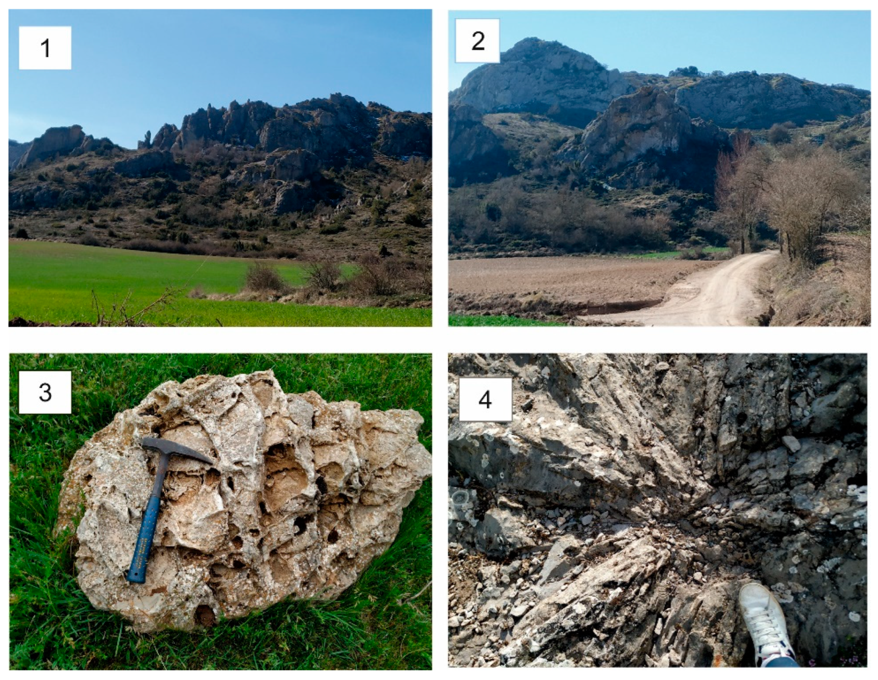
2.1.1. Regional Geological Context
2.1.2. Lithology and Geology
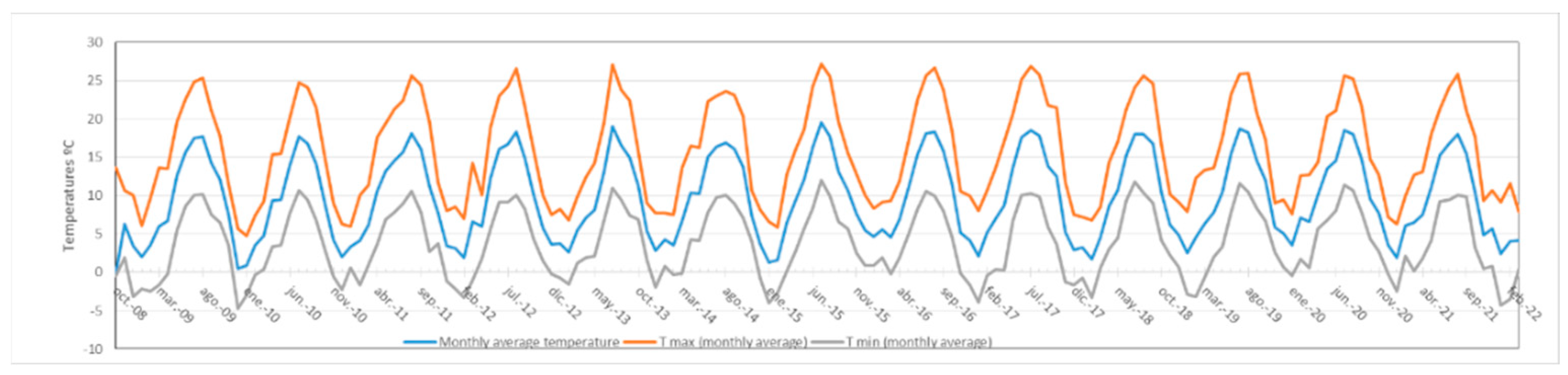
2.1.3. Climatology
2.1.4. Hydrology
2.1.5. Aquifers and Groundwater Bodies
2.2. Methodology
2.2.1. Literature Review
2.2.2. Field Campaigns
Water Samples
Physical–Chemical Analysis of Water
Construction of Hydrogeological Profiles
Analysis of Springs and Comparison Criteria
Integration of Results and Representation in Arc Gis
3. Results and discussion
3.1. Geodiversity of Las Loras UGGp
3.1.1. The Ubierna Fault
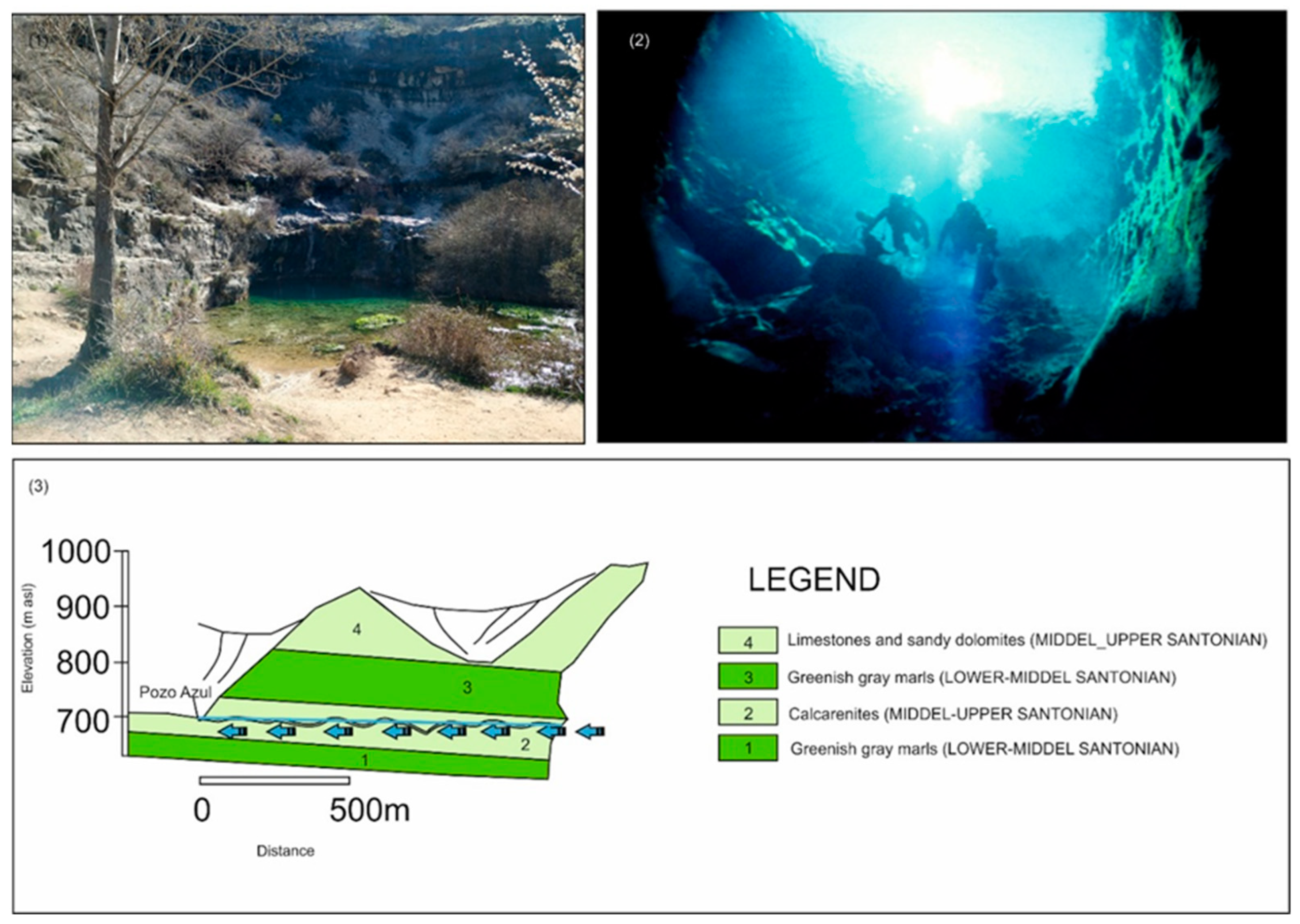
3.1.2. Caves
3.1.3. Springs
3.1.4. Travertine Buildings
3.1.5. Peat Bogs
3.1.6. Canyons and Sickles
3.1.7. Sinkholes
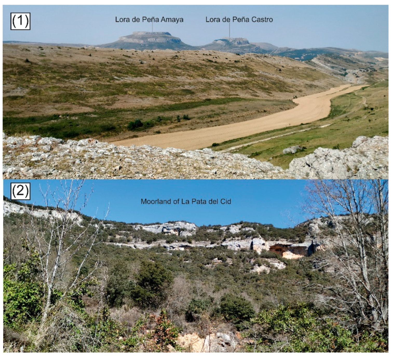
3.1.8. The Moorlands
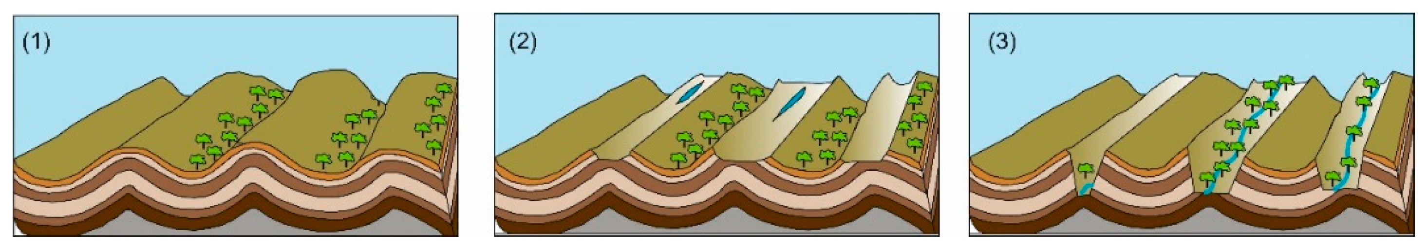
3.1.9. The Loras
3.2. Interpretation and Hydrogeological Significance
3.2.1. Analytical Results
3.2.2. Hydrogeological Context
3.2.3. Hydrogeological Characterization of Springs
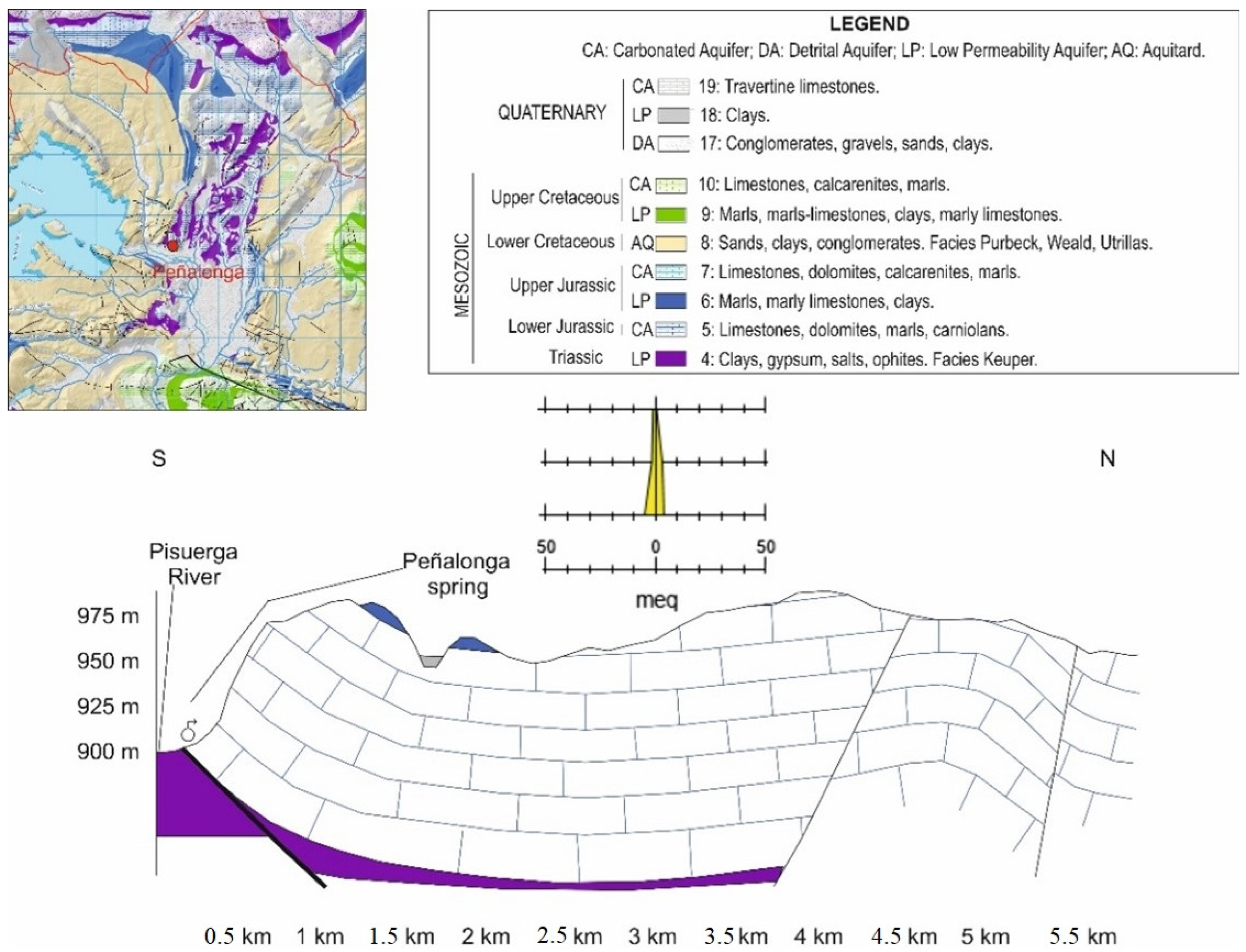
Peñalonga Spring
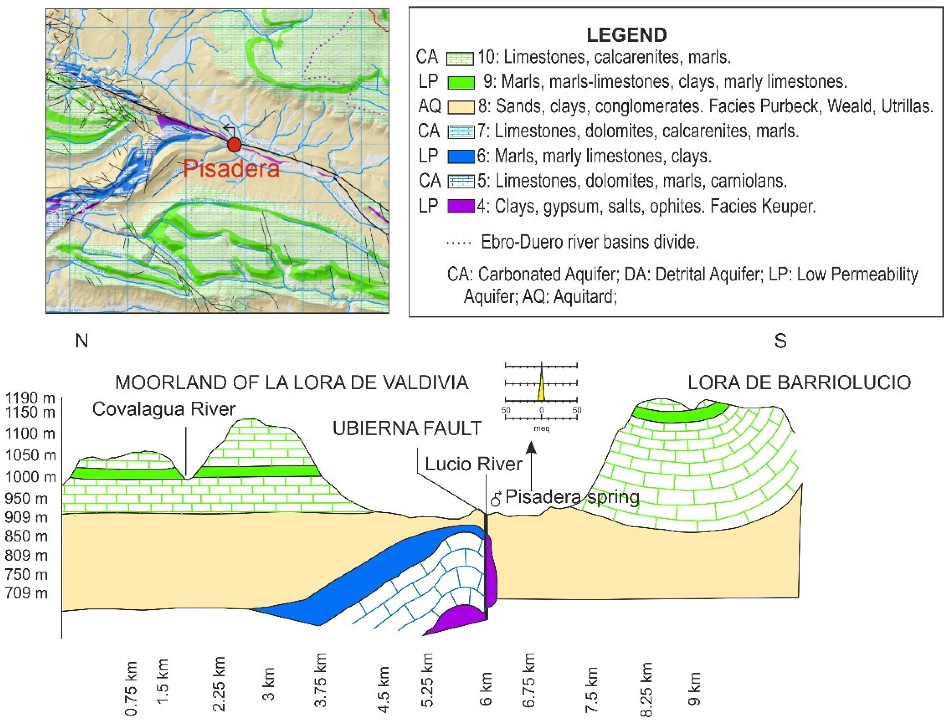
Spring of La Pisadera
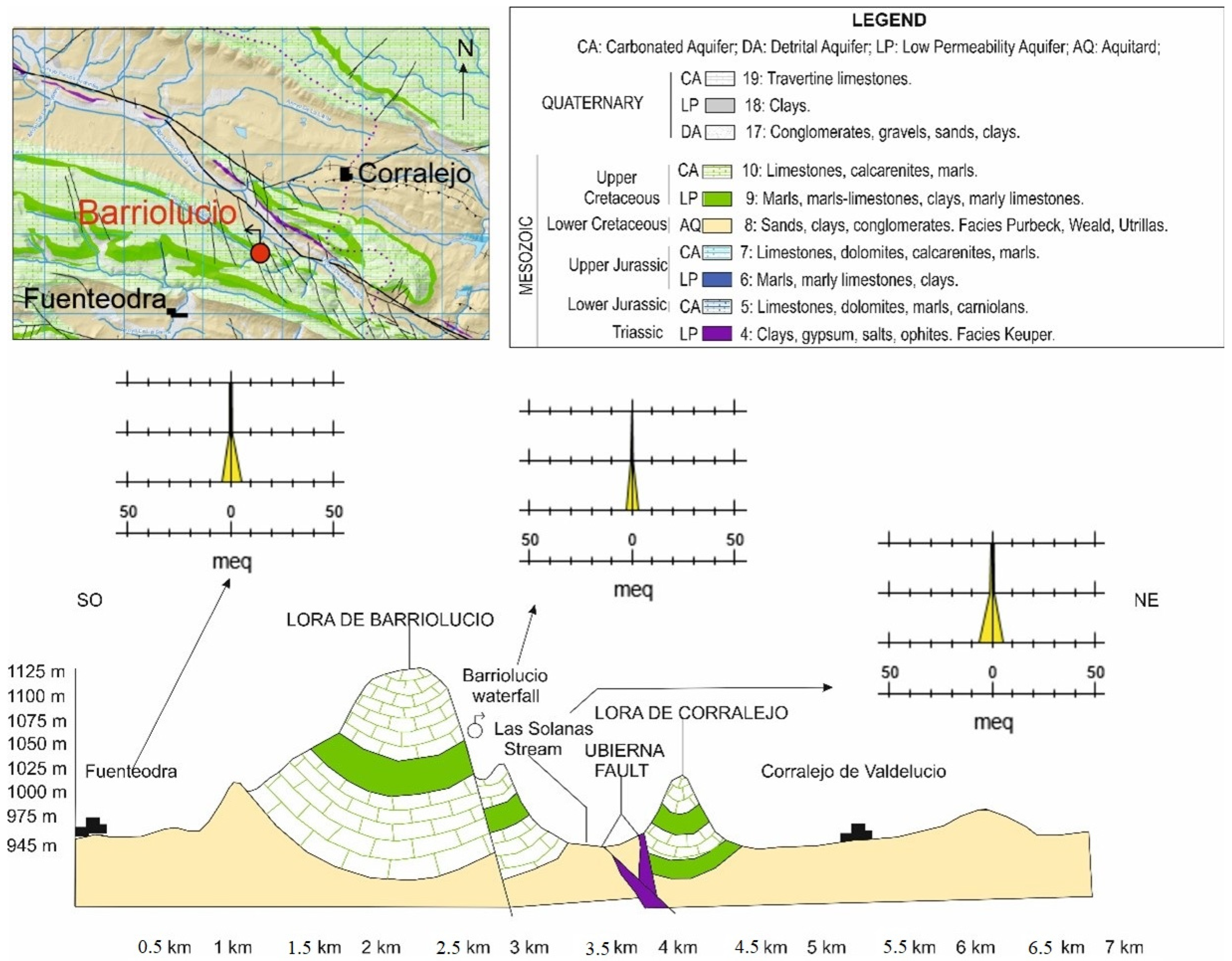
Fuentehoz Spring in Barriolucio
San Bol Spring
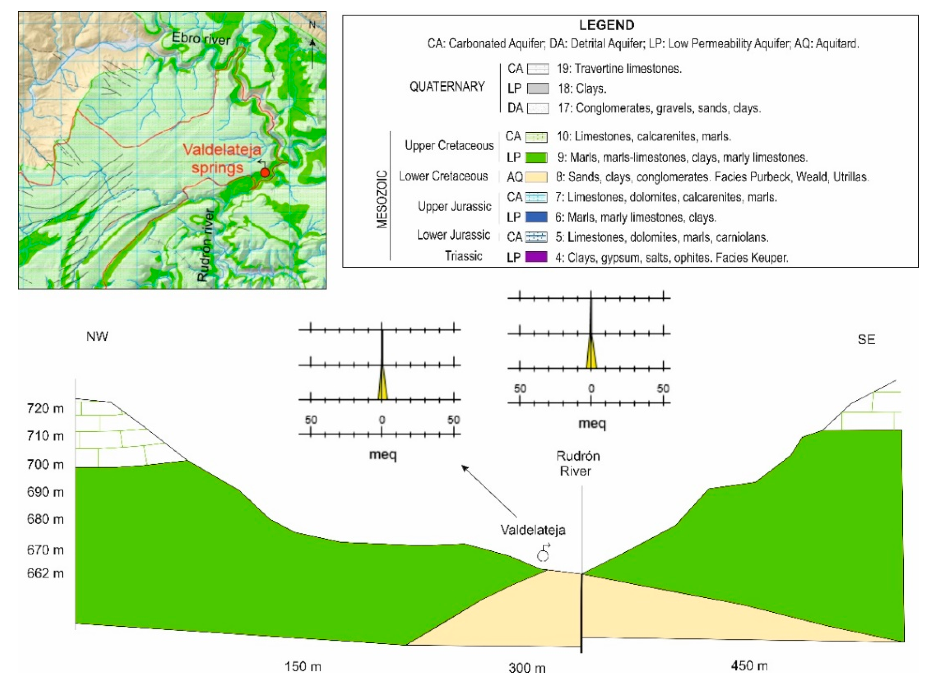
Valdelateja Springs
Springs of Orbaneja, Pozo Azul and Tubilla del Agua
Summary of Spring Characterization
3.3. Rivers
3.4. Hydrogeological Conceptual Model
4. Conclusions
Supplementary Materials
Author Contributions
Funding
Data Availability Statement
Acknowledgments
Conflicts of Interest
References
- Ruban, D.A.; Yashalova, N.N. Geodiversity meanings in global geoparks: An empirical study. Environ. Earth Sci. 2018, 77, 771. [Google Scholar] [CrossRef]
- Gray, M. Geodiversity. Valuing and Conserving Abiotic Nature; John Wiley & Sons: West Sussex, UK, 2004; p. 434. [Google Scholar]
- Carcavilla Urquí, L.; López Martínez, J.; Durán Valsero, J.J. (Eds.) Patrimonio Geológico y Geodiversidad: Investigación, Conservación, Gestión y Relación Con Los Espacios Naturales Protegidos; Publicaciones del IGME, Serie Cuadernos del Museo Geominero 7; Instituto Geológico y Minero de España: Madrid, Spain, 2007; p. 360. [Google Scholar]
- Pereira, P.; Brilha, J.; Gray, M.; Pereira, D.I. Rephrasing the geodiversity concept under the Ecosystem Services approach and the UN Sustainable Development Goals. In Proceedings of the Conference: EGU General Assembly 2019, Vienna, Austria, 7–12 April 2019; Volume 21. [Google Scholar]
- Sisto, M.; Di Lisio, A.; Russo, F. Geosite Assessment as a Tool for the Promotion and Conservation of Irpinia Landscape Geoheritage (Southern Italy). Resources 2022, 11, 97. [Google Scholar] [CrossRef]
- Testa, B.; Aldighieri, B.; D’Alberto, L.; Lucianeiit, G.; Mazza, R. Hydrogeology and hydromorphology: A proposal for a dual-key approach to assess the geo-hydrological heritage site of the San Lucano Valley (Belluno Dolomites, Italy). Geoheritage 2019, 11, 309–328. [Google Scholar] [CrossRef]
- Miljković, D.; Božić, S.; Miljković, L.; Marković, S.B.; Lukić, T.; Jovanović, M.; Bjelajac, D.; Vasiljević, A.; Vujičić, M.D.; Ristanović, B. Geosite Assessment Using Three Different Methods; a Comparative Study of the Krupaja and the Žagubica Springs-Hydrological Heritage of Serbia. Open Geosci. 2018, 10, 192–208. [Google Scholar] [CrossRef]
- Ley 42/2007, de 13 de diciembre, del Patrimonio Natural y de la Biodiversidad. BOE Núm. 299, de 14/12/2007. BOE-A-2007-21490. Available online: https://www.boe.es/buscar/act.php?id=BOE-A-2007-21490 (accessed on 1 October 2022).
- Guillén-Mondéjar, F.; Díaz Martínez, E.; de Santisteban, C.; Herrero, N.; Mata, J.M.; Meléndez, G. Protección, uso y gestión de la diversidad geológica (geodiversidad) y su patrimonio geológico de España. Propuestas de la Sociedad Geológica de España para los partidos políticos, legislatura 2011-2015. Geotemas 2012, 13, 1276–1279. [Google Scholar]
- Martínez Arnáiz, M. Loras y paramera de la Lora en Burgos. El incierto horizonte del desarrollo rural en un espacio de montaña media en recesión demográfica. Ph.D. Thesis, Universidad de Valladolid, Valladolid, Spain, 2013; p. 762. Available online: https://uvadoc.uva.es/handle/10324/4223 (accessed on 1 October 2022).
- Salman Monte, K.; Sánchez Fabián, J.A.; García García, F.; Basconcillos Arce, J.; Rodríguez García, A.; Gallego Rojas, N. (Eds.) Application Dossier to be a UNESCO Global Geopark. Proyecto Geoparque Las Loras; Diputación de Palencia, Diputación de Burgos y Junta de Castilla y León; Geoparque de Las Loras: Palencia, Spain, 2015; p. 50. [Google Scholar]
- Ramos, A.; Mediato, J.F.; Pérez-López, R.; Rodríguez-Pascua, M.A. Miocene to present-day tectonic control on the relief of the Duero and Ebro basins confluence (North Iberia). J. Maps. 2021, 17, 289–299. [Google Scholar] [CrossRef]
- DPB-IGME. Atlas del medio hídrico de la provincia de Burgos; Diputación Provincial de Burgos; Instituto Tecnológico Geominero de España: Madrid, Spain, 1998; Available online: https://aguas.igme.es/igme/publica/libro74/lib74.htm (accessed on 3 September 2022).
- IGME. Mapa Geológico de España 1/50.000 Polientes, Núm. 134 (18-8); Instituto Geológico y Minero de España (IGME): Madrid, Spain, 1994. [Google Scholar]
- IGME 1997a. Hoja Geológica MAGNA50 Núm. 133 (17-8). Prádanos de Ojeda; Instituto Tecnológico Geominero de España: Madrid, Spain, 1997. [Google Scholar]
- IGME 1997b. Hoja Geológica MAGNA50 Núm. 165 Herrera de Pisuerga; Instituto Geológico y Minero de España: Madrid, Spain, 1997. [Google Scholar]
- IGME 1997c. Hoja Geológica MAGNA50 Núm. 166 Villadiego; Instituto Geológico y Minero de España: Madrid, Spain, 1997. [Google Scholar]
- IGME 1997d. Hoja Geológica MAGNA50 Núm. 167 Montorio; Instituto Geológico y Minero de España: Madrid, Spain, 1997. [Google Scholar]
- CHD. Propuesta de Plan Hidrológico 2022-2027. Confederación Hidrográfica del Ebro. 2021. Available online: https://www.chebro.es/web/guest/revision-plan-hidrologico-tercer-ciclo (accessed on 22 August 2022).
- CHD Information System. Duero River Basin Web Page. Available online: https://mirame.chduero.es (accessed on 29 September 2022).
- De la Hera-Portillo, A.; Llorente-Isidro, M.; Moreno, L.; Sánchez, J.A.; Salman, K.; Corral, M.M.; Galindo, E.; López, J.; Ghanem, M.; Hind Mohammed, A.; et al. Geoheritage and geoconservation in the Las Loras UNESCO Global Geopark. In ProGEO SE Europe Regional Working Group. Virtual Conference on Geoconservation, 30–31 March 2022; Pereira, P., Monge-Ganuzas, M., Bollati, I.M., Rouget, I., Eds.; University of Minho: Braga, Portugal, 2022; pp. 14–16. [Google Scholar]
- De la Hera-Portillo, A.; Llorente, M.; López-Gutiérrez, J.; Salman, K.; Sánchez, J.A.; Gallego Rojas, N.; Ballesteros, D.; Moreno, L.; Corral Lledó, M.M.; Galindo Rodríguez, E.; et al. Hydrogeological Setting of Las Loras UNESCO Global Geopark (Palencia-Burgos, Spain): State of Knowledge and Needs for Water Resources Sustainability Research. In Eurokarst 2022, Málaga. Advances in karst Science; Andreo, B., Barberá, J.A., Durán-VAlsero, J.J., Gil-Márquez, J.M., Mudarra, M., Eds.; Springer: Cham, Switzerland, 2022; pp. 249–254. [Google Scholar] [CrossRef]
- Base de datos Puntos de Agua [Water Points database]. CN IGME. Base de Datos Puntos de Agua ©CN. Instituto Geológico y Minero de España (IGME). Available online: https://info.igme.es/BDAguas/ (accessed on 27 December 2021).
- Servicio WMA GEODE. Mapa geológico Continuo de España a escala 1:50.000 © CN Instituto Geológico y Minero de España (IGME). Available online: https://info.igme.es/cartografiadigital/geologica/Geode.aspx (accessed on 28 December 2021).
- ADIF-AECOM. Estudio Informativo de la línea de alta velocidad Nogales de Pisuerga-Reinosa. Apéndice 5. Geología y Geotecnia; Ministerio de Transporte, Movilidad y Agenda Urbana: Madrid, Spain, 2019; p. 172. [Google Scholar]
- ADIF-AECOM. Estudio Informativo de la línea de alta velocidad Nogales de Pisuerga-Reinosa. Apéndice 12. Estudio hidrogeológico; Ministerio de Transporte, Movilidad y Agenda Urbana: Madrid, Spain, 2019; p. 1287. [Google Scholar]
- Stiff, H.A. The interpretation of chemical water analysis by means of patterns. J. Pet. Technol. 1951, 3, 15–16. [Google Scholar] [CrossRef]
- De Moreno Merino, L.; De la Losa Román, A.; Romero Prados, A.; Carro Martín, S. Interpretación de análisis químicos de aguas subterráneas mediante la hoja INAQUAS. 2016. Luis Moreno Merino, Almudena de la Losa Román, Amalia Romero Prados, Sergio Carro Martín. Available online: https://www.igme.es/Publicaciones/Consulta/Libro/36830 (accessed on 11 March 2022).
- National Geographic Institute (IGN). Available online: https://www.ign.es/web/ign/portal (accessed on 17 September 2021).
- Arc GIS Pro 2.6.2. Copyright © 2020 Esri Inc. All Rights Reserved. Available online: https://support.esri.com/en/Products/Desktop/arcgis-desktop/arcgis-pro/2-6 (accessed on 15 July 2022).
- IGME; ENRESA. Neotectonic Map of Spain, Scale 1:1.000.000, and Memory of the Neotectonic and Seismotectonic Map of Spain, scale 1:1.000.000; IGME: Madrid, Spain, 1998; Volume 1. [Google Scholar]
- Base de Datos de Fallas Activas del Cuaternario v4. 2012. IGME. Available online: https://info.igme.es/qafi/ (accessed on 15 August 2021).
- IGME-IRMCDACM; Arenillas González, A.; Suárez Díaz, I. Atlas de Estructuras Del Subsuelo Susceptibles de Almacenamiento Geológico de CO2 En ESPAÑA; Suárez Díaz, I., Ed.; Instituto Geológico y Minero de España: Madrid, Spain; Instituto para la Reestructuración de la Minería del Carbón y Desarrollo Alternativo de las Comarcas Mineras: Madrid, Spain, 2014. [Google Scholar]
- Pulgar, J.A.; Alonso, J.L.; Espina, R.G.; Marín, J.A. La deformación alpina en el basamento varisco de la Zona Cantábrica. Trabajos de Geología 1999, 21, 283–294. Available online: https://reunido.uniovi.es/index.php/TDG/article/view/2902 (accessed on 1 September 2022).
- Hernáiz, P.P. La falla de Ubierna (margen SO de la cuenca Cantábrica). The Ubierna falut (S.W. margin of the Cantabrian basin). Geogaceta 1994, 16, 39–41. [Google Scholar]
- Rubio, F.M.; Ayala, C.; García Senz, J.; Rey Moral, C.; García Lobón, J.L.; Ortiz, G.; de Dios, J.C. Caracterización mediante gravimetría de la estructura geológica de Hontomín (Burgos). In 8ª Asamblea Hispano Portuguesa de Geodesia y Geofísica; Instituto Geológico y Minero de España (IGME): Madrid, Spain, 2014. [Google Scholar]
- Rioseras, M.; Acha Alarcía, J.; Grupo Espeleológico Edelweiss. Cavidades de Orbaneja del Castillo I. El Conejal-Entrecaminos-Pico Resanquillo; Valle de Sedano: Burgos, Spain, 2016; pp. 12–33. Available online: http://grupoedelweiss.com/pdf/Cubia20.Orbaneja_I.pdf (accessed on 1 October 2022).
- Ruíz García, F.; Ortega Martínez, A.I.; Martín Merino, M.A. (Eds.) El Karst de Burgos; Grupo Espeleológico Edelweiss (GEE): Burgos, Spain, 2022; pp. 34–63. Available online: https://xdoc.mx/documents/descarga-completa-grupo-espeleologico-edelweiss-5eb5c9e4ade01 (accessed on 30 September 2021).
- Grupo Espeleológico Edelweiss (GEE). Cuevas de Orbaneja del Castillo. 2012. Available online: https://www.grupoedelweiss.com/web/index.php/principales-karst-mainmenu-49/rutas-espeleologicas/101-cuevas-de-orbaneja-del-castillo (accessed on 29 September 2022).
- Sanz Pérez, E.; Medina Ferrer, J. La morphologie karstique souterraine du Pozo Azul (“Puits Bleu”) de Burgos (Espagne). Karstologia 1986, 8, 27–50. [Google Scholar] [CrossRef]
- Edelweiss Public Web Page. Available online: https://www.grupoedelweiss.es/web/index.php/el-grupo-mainmenu-76 (accessed on 26 October 2022).
- González Amuchástegui, M.J.; Serrano Cañadas, E. Acumulaciones tobáceas y evolución del paisaje: Cronología y fases morfogenéticas en el Alto Ebro (Burgos). Cuatern. Y Geomorfología. 2013, 27, 9–32. [Google Scholar]
- Hera-Portillo, D. Informe Sobre el Posible Hidrotermalismo Asociado a la Falla de Ubierna [Report on the Potential Hydrotermalism Associated to Ubierna Fault]; Argeol Association: Palencia, Spain; Instituto Geológico y Minero de España-Consejo Superior de Investigaciones Científicas (IGME-CSIC): Madrid, Spain, 2023; Unpublished report. [Google Scholar]
- Serrano Cañadas, E.; González, M.J. Las Tobas y la Villa de Orbaneja del castillo. Un entendimiento obligado. In Patrimonio geológico y geoparques, avances de un camino para todos/Miren Sorkunde Mendia Aranguren (ed. lit.), Asier Hilario Orús (ed. lit.), Manuel Monge Ganuzas (ed. lit.), Esperanza Fernández Martínez (ed. lit.), J. Vegas (ed. lit.), Ángel Belmonte (ed. lit.); Instituto Geológico y Minero de España (IGME): Madrid, Spain, 2015; pp. 197–202. [Google Scholar]
- Iberpix. Instituto Geográfico Nacional. Available online: https://www.ign.es/iberpix2/visor (accessed on 15 August 2021).
- Piper, A.M. A graphic procedure in the geochemical interpretation of water-analyses. Eos. Trans. Am. Geophys. Union 1944, 25, 914–928. [Google Scholar] [CrossRef]
- Durov, S.A. Natural Waters and Graphic Representation of Their Composition. Dokl. Akad. Nauk. SSSR 1948, 59, 87–90. [Google Scholar]
- Chadha, D.K. A proposed new diagram for geochemical classification of natural waters and interpretation of chemical data. Hydrogeol. J. 1999, 7, 431–439. [Google Scholar] [CrossRef]
- Cidad Pérez, J. Valle de Valdelucio (Apuntes Historia). Editorial Monte Carmelo. p. 228. 1986. Available online: https://www.todostuslibros.com/libros/valle-de-valdelucio-apuntes-historia_978-84-7239-173-4 (accessed on 21 September 2021).
- IGME-SIEMCALSA. Estudio y Evaluación del Potencial Hidromineral de Castilla y León. Ficha Resumen Explotaciones Activas; Instituto Geológico y Minero de España, Sociedad de Investigación y Explotación Minera de Castilla y León: Burgos, Spain, 2008; Available online: https://www.igme.es/aguas_minerales/inventarios/castillayleon/PDFs/Fase%203/67.pdf (accessed on 17 September 2021).


| River | Name | Geomorphological Context | Altitude (m asl) | Site | Reference |
|---|---|---|---|---|---|
| Rudrón | El Tobazo | Hillside | ≈850 | Tubilla del Agua | [42] |
| Rudrón | La Toba | Hillside | ≈850 | Tubilla del Agua | [42] |
| Rudrón | Tubilla-La Fuentona | Valley bed | 810–710 | Tubilla del Agua | [42] |
| Rudrón | La Tobaza | Hillside | ≈850 | Tubilla-Covanera | [42] |
| Rudrón | Spa | Valley bed | 670 | Valdelateja | [42] |
| Rudrón | Valdelateja | Valley bed | 660 | Valdelateja | [42] |
| Rudrón | Ebro-Rudrón | Valley bed | Valdelateja | [42] | |
| Ebro | Agua Cave-Orbaneja | Hillside * | 800–720 | Orbaneja | [42] |
| Ebro | La Tobaza | Hillside | ≈730 | Orbaneja | [42] |
| Lucio | Barriolucio | Waterfall/Hillside | ≈990 | Barriolucio | [43] |
| Covalagua | Covalagua | Waterfall/Hillside | ≈1030 | Revilla de Pomar | [43] |
| Rudrón | Moradillo del Castillo | Waterfall/Hillside | ≈810 | Moradillo del Castillo | [43] |
| Mundilla stream | Villaescobedo | Waterfall/Hillside | ≈1100 | Villaescobedo | [43] |
| No | Name | Maximum Altitude (m asl) | Length (km) | Width (km) | Nearest Villages | Springs |
|---|---|---|---|---|---|---|
| A | Moorland of la Lora de Valdivia | 1222 | 6.85 | 4.92 | Revilla de Pomar-Villescobedo | Covalagua, Villaescobedo |
| B | Moorland of la Lora de la Pata del Cid | 1063 | 22.20 | 14.14 | Villaescobedo, Orbaneja, Valdelateja | Upwelling of Rudrón river, Ceniceros, Valdelateja |
| 1 | Lora de Peña Amaya | 1370 | 5.3 | 2.7 | Amaya-Villamartín de Villadiego | Fuente Prabal, Manantial de las Quintanas, Fuente de Oncejuelo |
| 2 | Lora de Albacastro | 1349 | 6.78 | 2.7 | Albacastro, Puentes de Amaya | Manantial de la Ceña, Manantial de Hoya Redonda, Fuente de la Legaña, Fuente de la Turquilla |
| 3 | Lora de Rebolledo de la Torre | 1243 | 7.96 | 2.55 | Rebolledo-Castrecias | Manantial de la Raposa, Fuente de San Roque |
| 4 | Lora de Ulaña o de Humada | 1206 | 7.09 | 1.4 | Humada-Ordejón de Abajo | Fuente de San Pedro, Manantiales de Vallejo, Fuente del Carril |
| 5 | Lora de Barriolucio | 1193 | 25.5 | 2.99 | Barriolucio-Fuenteodra | Barriolucio, Manantial de la Magdalena |
| 6 | Lora de Pinza | 1107 | 7.38 | 6.6 | Urbel del Castillo | Manantial de la Recova, Manantial del Pradal, Manantial de Tarancón, Manantiales del Olmo, Manantial de las Matas, Manantial de los Pradillos, Manantial de la Pedrosa, Manantial de los Milagros |
| 7 | Lora de Corralejo | 1161 | 6.7 | 1.65 | Corralejo-Solanas de Valdelucio | Fuente Cuevas, Fuente de Ostra |
| 8 | Lora de Fuente Urbel | 1085 | 5.15 | 3.05 | S de Fuente Urbel | Fuente Urbel, Manantial de Valledrías, Manantial de Trescuevas, Manantial de Valdehayas |
| 9 | Lora de Cuevas de Amaya | 1150 | 3.65 | 1.57 | Rebolledillo-Cuevas de Amaya | Fuente del Obispo, Fuente Ritoba, Fuente Junquera |
| 10 | Lora de Villela | 1077 | 2.38 | 3.16 | Villela-Rebolledillo de la Orden | Fuente Gatón, Fuente Mijo |
| 11 | Lora de Monte Carrascal | 1035 | 4.26 | 1.61 | San Pantaleón del Páramo-Montorio | Manantial de Valdemudo |
| 12 | Lora de Las Tuerces | 1087 | 6.85 | 2.63 | Villaescusa de las Torres | - |
| Formation | Aquifer | Aquitard | Aquifuge |
|---|---|---|---|
| Quaternary | X | ||
| Maastrichtiense | X | ||
| Campaniense | X | ||
| Campaniense | X | ||
| Upper Santoniense | X | ||
| Lower Santoniense | X | ||
| Coniaciense/Turoniense | X | ||
| Cenomaniense–Albiense (Utrillas) | X | ||
| Apt-Albiense | X | ||
| Valong. Barremiense | X | ||
| Portlandiense–Upper Kimmeridgiense (Purbeck) | X | ||
| Dogger | X | ||
| Dogger Batho. | X | ||
| Dogger Bajo. | X | ||
| Upper Lias-Alb. | X | ||
| Lower Lias-Alb. | X | ||
| Trias | X |
| Code | Geological Age | Description |
|---|---|---|
| C-7 | Upper Santoniense–Lower Campaniense | Calcareous sandstones, dolomites and limestones with rudists and foraminifera |
| C-6 | Upper Santoniense | Glauconitic marls and limestones |
| C-5 | Medium Santoniense | Calcarenites with “Lacazina Elongata” |
| C-4 | Lower Santoniense | Calcareous marls and marly limestones |
| C-3 | Medium Turoniense–Upper Coniaciense | Sandy limestones, oolitic limestones and limestones with rudists |
| C-2 | Medium Turoniense | Sandy loams |
| C-1 | Cenomamiense | Sands, microconglomeratic sandstones |
| C-0 | Utrillas Facies | Sands, microconglomeratic sandstones and clays |
| Parameter | 6 June 2022 | 19 August 2022 |
|---|---|---|
| EC (µS/cm) | - | 612 |
| pH | 7.15 | 6.47 |
| T (°C) | 10.76 | 14.8 |
| Redox Potential (mV) | - | 25.5 |
| Cl | SO4 | CO3H | CO3 | NO3 | Na | Mg | Ca | K | pH | CE | NO2 | NH4 | PO4 | SiO2 |
|---|---|---|---|---|---|---|---|---|---|---|---|---|---|---|
| 1 | 10 | 197 | 0 | 0 | 0 | 7 | 62 | 0 | 7.63 | 330 | 0 | 0 | 0 | 2.8 |
| Discharge Level (m asl) | Geological Formation | Hydrochemical Facies | EC (μS/cm) | Examples |
|---|---|---|---|---|
| 970–1200 | Upper Cretaceous | CaCO3H− | 400–500 | Covalagua, Barriolucio |
| 940–960 | Paleogene | CaCO3H− | 350 | Fuente Urbel |
| 900–920 | Jurassic | CaCO3H− | 595–695 | Peñalonga, Pisadera |
Disclaimer/Publisher’s Note: The statements, opinions and data contained in all publications are solely those of the individual author(s) and contributor(s) and not of MDPI and/or the editor(s). MDPI and/or the editor(s) disclaim responsibility for any injury to people or property resulting from any ideas, methods, instructions or products referred to in the content. |
© 2023 by the authors. Licensee MDPI, Basel, Switzerland. This article is an open access article distributed under the terms and conditions of the Creative Commons Attribution (CC BY) license (https://creativecommons.org/licenses/by/4.0/).
Share and Cite
de la Hera-Portillo, Á.; López-Gutiérrez, J.; Moreno-Merino, L.; Llorente-Isidro, M.; Fensham, R.; Fernández, M.; Ghanem, M.; Salman, K.; Sánchez-Fabián, J.Á.; Gallego-Rojas, N.; et al. Geodiversity of Las Loras UNESCO Global Geopark: Hydrogeological Significance of Groundwater and Landscape Interaction and Conceptual Model of Functioning. Resources 2023, 12, 14. https://doi.org/10.3390/resources12010014
de la Hera-Portillo Á, López-Gutiérrez J, Moreno-Merino L, Llorente-Isidro M, Fensham R, Fernández M, Ghanem M, Salman K, Sánchez-Fabián JÁ, Gallego-Rojas N, et al. Geodiversity of Las Loras UNESCO Global Geopark: Hydrogeological Significance of Groundwater and Landscape Interaction and Conceptual Model of Functioning. Resources. 2023; 12(1):14. https://doi.org/10.3390/resources12010014
Chicago/Turabian Stylede la Hera-Portillo, África, Julio López-Gutiérrez, Luis Moreno-Merino, Miguel Llorente-Isidro, Rod Fensham, Mario Fernández, Marwan Ghanem, Karmah Salman, Jose Ángel Sánchez-Fabián, Nicolás Gallego-Rojas, and et al. 2023. "Geodiversity of Las Loras UNESCO Global Geopark: Hydrogeological Significance of Groundwater and Landscape Interaction and Conceptual Model of Functioning" Resources 12, no. 1: 14. https://doi.org/10.3390/resources12010014