1. Introduction
Springs are unique ecosystems and considered as a vital water cycle component to support the integrity of biodiversity and geodiversity in the Nature. However, in many cases, they are severely threatened and thus require an urgent need for better management and conservation [
1]. Identifying the physical, chemical, and microbiological characteristics of spring water is a critical step in managing the Geopark springs. Geoparks are areas of the landscape with the goal of achieving a sustainable physical development between the uses of land and economic development [
2].
Among these characteristics, it is essential in environmental planning to efficiently manage the water quality of these natural resources. They are essential parameters in directing the efforts to remove potential sources of contamination from the spring’s drainage area and select water purification units [
3].
The hydrochemical parameters are the leading indicators of water quality for the springs. The hydrochemistry of the springs will indicate to which extent the spring water is suitable for drinking or agricultural purposes. Spring water has been the primary drinking source in rural Palestinian communities throughout the previous decades [
4]. This fact explains why the springs have a high value as geological heritage for citizens. Spring water typically has good quality compared to other water resources due to filtration in soil and rock-forming reservoirs [
5]. However, locative differences in groundwater quality depend on the geological structure through which it flows and human activities near the groundwater basin [
6]. The quality of spring water is controlled by geological and hydrogeological conditions, water–rock interaction, and water residence time in the aquifer. It is also influenced by anthropogenic activities such as urbanization, industrial expansion, and agricultural activities around Jericho Geopark [
7]. Water deterioration of springs can be attributed to the recharge processes to the groundwater aquifer [
8] related to human activities, mainly irrigation which provides fertilizers such as As and NO
3, which become part of the groundwater when they reach the saturated zone of the aquifer. Physical, chemical, and microbiological pollutants, related to different causes and health-associated issues and results, can contaminate spring water. There are notable concerns about the quality of accessible water gained momentum with an ever-increasing demand for limited water resources and the need for water treatment [
9].
Springs played a significant role in localizing the potential Jericho Geopark [
10]. Over time, excessive groundwater usage in urban areas can affect groundwater conditions including springs both in quantity and quality [
11]. The outcropping in the Eastern side of the Jordan Valley, the so-called West Bank, is sedimentary rocks composed of limestone, dolomite and marly limestone rock, while the others are composed of evaporates of Lisan formations. There are few studies about the hydrochemistry of the springs in the West bank. Hydrochemistry of Faria drainage basin/West bank was studied [
12] and revealed that the Faria springs were found to be of the Calcium Bicarbonate type and not polluted. The hydrogeology and hydrochemistry of springs and groundwater dug wells of the Hebron District were studied [
13]. The wide distribution of cesspools and septic tanks in the West bank cause rapid contamination of aquifer systems through karstic conduits in the area. The springs of the entire West bank was studied [
14] and revealed that the majority of them are of karstic origin. The assessment of the microbiological and physiochemical quality parameters of drinking water from the licensed springs by the Palestinian Water Authority in the West Bank was studied [
15] and revealed that the majority of them are within the WHO acceptable standard limits.
The project research results are part of a project research focusing on the hydrogeological settings of the Geoparks water in the southern Mediterranean countries of Palestine, Jordan, Tunisia, Morocco, Egypt and Spain (Northwestern). Those Mediterranean countries consist of a rich geodiversity, and there are limited research studies undertaken in geoheritage and their related hydrogeology. The project of hydrogeological significance will be impacted in relation to increasing the awareness of the local population and decision makers regarding the need for sustainable use and management of geoheritage sites, in particular for the benefit of local socio-economic sustainable development targets through the promotion of both geotourism and the creation of unique geoparks. The study results will add value into the water resources’ management integration from quantitative and qualitative point of views. The determined hydrogeological complex settings around these water sources will strengthen the Geopark potentiality for initiating geological touristic bases for societies. The qualitative resulting innovative project results will support achieving global water sustainability. The human activities around these water resources cause negative qualitative changes. The natural and human effects will be determined in order to create a protection base policy that will help the decision makers in the management planning of increasing the geotouristic volubility of these sites. This will increase the social cohesion to these sites. The results will make a major contribution to informal and formal geo-education by sharing scientific and geo-cultural knowledge. Inventory of geoparks will benefit for the local sustainable development of geo and hydrogelogical heritage in all values to strong international networking.
The inventory and assessment of a geopark in a territory provide a sound basis for the protection and use of its geological heritage. Geoheritage represents an important part of natural and cultural Geoparks, and provides society with a broad range of services that are fundamental for its socioeconomic development. In order to achieve the protection and conservation of Geoparks, one strategy is the identification and estimation of the probable impacts produced by human activity and assessing the environmental impact of the Geoparks [
16]. The Geopark studies contribute to the geomorphological heritage and geo-tourism, which brings added values to the sustainable social development [
17]. When the constituent elements of geodiversity have a high scientific value, they are known as geological heritage or geoheritage [
18]. Geoheritage is inherent to natural heritage. It includes forms, elements, and structures originated by the geological process and has a crucial role in understanding Earth’s history [
18,
19].
This study analyzed the hydrochemical characteristics and water quality of nine springs distributed along the Central part of the Jordan Rift Valley (Jericho-Auja area). The study addressed characterizing the springs as a tool to support the information required to achieve the Geopark recognition and to show its geodiversity from the hydrogeological point of view. This will be enhanced by determining the pollution level of these springs for their physical and chemical parameters. The purpose of the study will be to consolidate the hydrochemical imprints on the water system lives and emphasize the geological settings in the area. The study highlights in how this geo-cultural heritage of the area in the future planning will be preserved.
1.1. Study Area
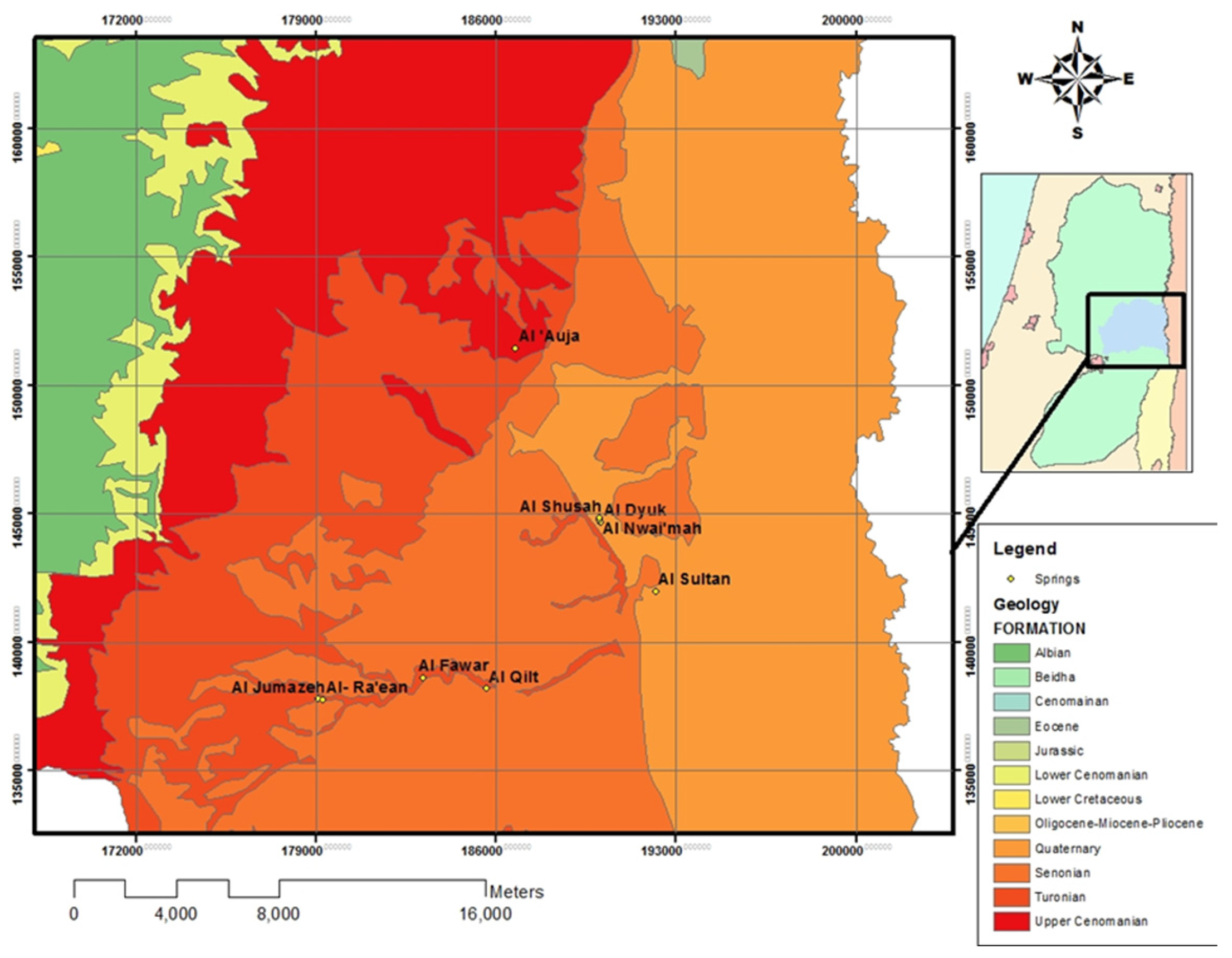
The southern part of the Jordan Valley (Jericho-Auja area) is considered to be an essential outlet of the underground water and comprises the springs of Auja, Nwai’mah, Dyuk, Ein Sultan, and Qilt (
Figure 1). These springs differ significantly in their hydrological, physical, and chemical characteristics/indicators [
20,
21], which mean that each should be considered separately as a unique water system with unique socio-economic varying widely feasures. The groundwater of the study area generally flows towards the Jordan Valley. These springs constitute around 40% of the total annual spring discharge in the West bank. The springs are used for domestic and agricultural purposes.
The water resources in the Al Auja spring area in terms of rainfall–runoff relation, base flow, and recession for the major springs, and the sustainable yield of the lower aquifer of Ein Samia well field was assessed [
22]. Hydrogeological and hydrochemical studies were conducted for the North Western Auja Tamaseeh basin (Tulkarm area) [
23] and represented a highly sensitive area for pollution, and the study was used as an assessment tool for the evaluation of the human activities on groundwater quality. Springs in Natuf drainage basin are of good water quality, except those near populated areas such as Ein Musbah, Al Alaq, and Ein Ayoub springs, which have low water quality for agricultural and domestic uses based on SAR, SSP, and EC values and are considered as microbially contaminated [
24]. The anthropogenic nitrate as well as the dissolved organic carbon in the Sarida springs water have spatial and temporal variations [
4]. A water quality study of Al Qilt springs showed moderate levels of major ions and higher concentrations of lead and cadmium than allowable concentrations for drinking water in three spring samples, whereas some springs were microbially contaminated, which indicates the infiltration of pollutants in the recharge area of the springs [
3,
25].
There are four main spring systems in the Jericho district emerging from the eastern groundwater basin underlying the Jericho area as follows:
Wadi Al-Qilt Spring System: —It is composed of three main springs—Ein Fara, Ein Fawwar, and Ein Al-Qilt—with an average monthly discharge of 146,775 m³. It is discharging through Turonian outcropping;
Ein Al-Sultan Spring System:—It is located at the eastern side of Wadi Al-Qilt and related to the Upper Cenomanian-Turonian Aquifer. The total monthly discharge of this system is 877,765 m³ with significant monthly and annual fluctuations;
Al Dyuk Spring System:—It is composed of three springs: Dyuk, Nwai’mah, and Shusah. The average monthly discharge of the springs in this system is 191,402 m³. They drain from the Pleistocene Lisan Formation and are fed from the Cenomanian Ajlun aquifers;
Al-Auja Spring System:—It drains from the Upper Cenomanian-Turonian aquifer.
The four spring systems are discharging from Turonian to Upper Cenomanian aquifers and relating to complex geological structural faults and folds due to the formation of Jordan Rift Valley.
1.2. Potential Jericho Geopark
Springs played the major role for localizing the majority of the Palestinian villages according to their water needs. The unique system plays an interesting role in the past and present for changing the environmental and human situations in all kinds of life. The Palestinian springs act as a nucleus of ancient civilizations and are considered one major component of the Palestinian heritage, reflecting the Palestinian identity in all its plurality and complexity.
Ancient Jericho is considered to be the first civilized site for the last 12,000 years. The Geology of the area played a good role in having groundwater reservoirs and in restoring the water above the surface in pools. This will be illustrated in how this system will be affected in increasing the internal and international touristic activities. Palestine has famous in the existing of numerous cultural heritage sites spreading all over the country. The existence of these sites represents special hydrological processes, which affect the nearest water source that was feeding them during their civilized appearance. Many of these sites are UNESCO listing sites like the Ein es Sultan site (
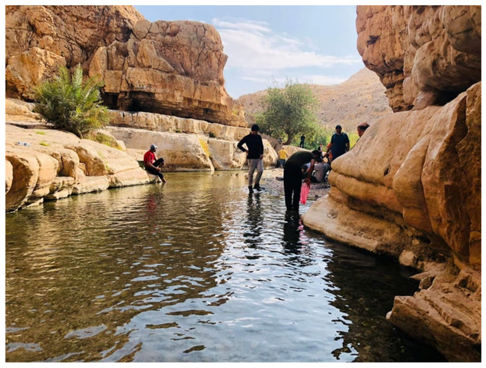
Figure 2) and Qilt spring (
Figure 3). One of the most touristic historical sites is Tel es Sultan, the ancient city of Jericho (UNESCO heritage site). It consists of many geological complex clusters: Ein Sultan, Qilt, Dyuk, and al Auja (
Figure 1). These cultural sites are investigated from civilized history and their influenced water related source. The ancient civilizations were connected to their drinking and agricultural water sources. The geohydrological complex around these spring clusters was determined in order to understand its potentiality for initiating Geological touristic roles as well as Geoparks in the area.
The spring water suitability is influenced by different geological, climatic change, and hydrogeological factors. The water cycle qualitative evolution that affected the interactions of the Geopark sites with their related hydrogeological aquifers was determined in order to address the related Geopark water availability and affordability. The geological outcropping as well as hydrogeological processes reflect the emerging of the spring’s image in the Jericho area.
The springs are playing fundamental roles in the settlement of ancient civilizations.
1.3. Hydrogeological System
The main aquifer systems in the Jericho region where the springs are located are Lower Albian, Upper Cenomanian-Turonian, Tertiary, and Quaternary (
Figure 4).
The Lower Albian Aquifer System is composed of the Lower Beit Kahil, Upper Beit Kahil, and the Yatta geological formations (
Table 1). The Lower Beit Kahil Formation and Upper Beit Kahil Formation and the lower part of the Yatta Formation comprise the lower aquifer, which is deeply confined across most of the West Bank. It is an excellent regional source of drinking water, and the high water bearing capacity and productivity reflect the thickness of dolomitic limestone and limestone.
The Upper Aquifer consists of the Turonian (Jerusalem Formation) and Cenomanian (Bethlehem and Hebron formations) in addition to karstic aquifers with good water quality with slight salinity on its eastern borders.
Turonian aquifer formation (Jerusalem) consists of massive limestone and dolomitic limestone with well-developed karst features. It consists of the upper aquifer, and it becomes thin on the eastern sides of the West Bank. It is considered as a good aquifer of tens of meters of saturation thickness. Its water quality is generally good, but, in some areas, its deteriorated water is because of sewage and agro-chemical pollution. Other geological formations of the lower and upper aquifer systems existed in Tertiary and Quaternary outcroppings (
Table 1).
1.4. Geological Settings
The geological outcropping in the potential Jericho Geopark area consists of sedimentary rocks dating Quaternary and Lower and Upper Cretaceous Formations (
Table 1). Upper Cenomanian formations are composed of Hebron and Bethlehem Formation. The Hebron formation is composed of brittle karstified gray dolomite, dolomitic limestone, and gray limestone. Bethlehem formation is composed of hard dolomite and dolomitic limestone with some silicification. Upper Cenomanian formations consist of Lower and Upper Beit Kahil and Yatta formations [
28]. The upper part of Lower Beit Kahil is made of dolomite that is massively bedded with hard fine crystals of dark gray color. The Lower Beit Kahil formation consists of alternating limestone layers with marl. The distinctive difference between the Lower and Upper Beit Kahil formations is the increase of marl in the Upper Beit Kahil. The Yatta formation that outcrops at the Jericho area is made of light marly stones with few limestones. Turonian formation (Jerusalem) covers the western and northwestern parts of the Jericho area. Its lithology is characterized by karstified limestone and dolomite with marl and clay mainly near the bottom. Senonian rock formation (Abu Dis) is composed of chalks and marls. The chalk is usually white and fractured, but, in some areas, it is dark colored due to the presence of bituminous materials. In the Quaternary formations, Pleistocene to Eocene rock formations are outcropped and composed mainly of limestone, chalks, marls, and siltstone. The Neogene succession formations are built mainly of marine and continental clastic formations, marine and limnic chalk, evaporates, and magmatic rocks [
26]. The thickness varies between a few hundreds of meters on the rift shoulders to a few thousands in the deep centers. Structural features of normal faults are dominant and a 9 km long fault with prominent E–W striking with an 80 m throw to the southeastern direction. Alluvial deposits are present along the western sides of Jericho and consist of unconsolidated lenticular beds of gravels, sands, clay, and laminated marls. The thickness of these deposits is highly variable and becomes relatively big near the foothills in the west and small in the east. They are bordered structurally by the Jordan rift regional fault in the east and another major fault of 12 km length in the west [
25]. The Lisan formation covers a large part of the Jordan Valley, and consists mainly of laminated marl, gypsum, and clay with some sand beds and pebbles. The best exposures are found along the Jordan River flood plain sides.
The regional structure of major importance to the potential Jericho Geopark area is the formation of the Jordan Rift Valley as part of the Dead Sea transform fault, which has an overall left lateral transform motion of 105 km from the Miocene age [
29]. Due to the stronger compressional character of the Dead Sea transform fault, the Jordan Rift valley became a structural system composed of step faults resulting in transpression and pressure releasing features by strain releasing bands and rhomb-shaped grabens. The Jericho area is bounded in the west by a major Jericho fault which separates the Cretaceous from the Quaternary outcroppings, where the major springs of Qilt, Fara, and Fawar are emerging (
Figure 5).
3. Results and Discussion
The water spring samples were analyzed for their hydrochemical parameters of Ca
2+, Mg
2+, Na
+, K
+, Cl
−, SO
42−, NO
3− and HCO
3−, as major ions, and pH, DO and EC, in order to understand the hydrochemical characteristics of the water springs as well as to understand their variability trends in the east-west directions. The hydrochemical parameters of major ions as well physical parameters of EC, TDS, DO, pH and T with their statistical data of their average, minimum and maximum values of the analyzed spring’s data are illustrated in
Table 3 and
Table 4. The physical parameters of EC and TDS values are ranging between 679 to 508 and 321 to 249 mg/L respectively (
Figure 6). Their values prove their suitability for drinking purposes. The pH concentration values are ranging between 6.9 to 7.8 and their temperature values are ranging within 21 and 23.3 degrees centigrade (
Figure 7). There is a variability in DO from 2.6 in Fawwar spring to 9.1 mg/L in Al Dyuk cluster springs (
Figure 7). The low DO concentration in Fawwar spring reveals the deep aquifer recharge of the spring sources and improves the cascade flow movement of the groundwater flow during the recharge feeding discharges of the spring. The high DO concentration of the other spring water agrees with the shallow recharge feeding sources of the spring discharges.
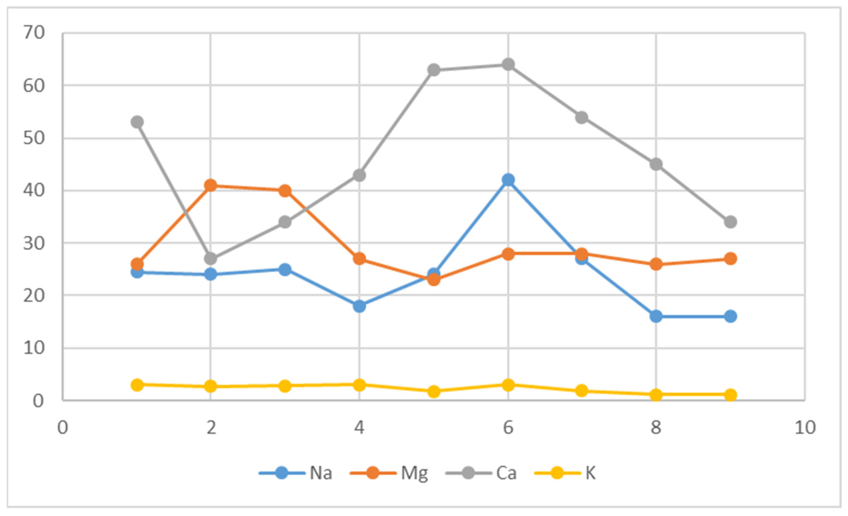
The major cations and anions concentration of the analyzed springs are illustrated in
Figure 8 and
Figure 9. The average concentration of Ca
2+ and Mg
2+ are 46.3 and 29.6 mg/L, respectively, which reflects the carbonate nature of these springs. The average concentration of Na
+ is 24 mg/L, and the lowest values are found in the Qilt spring system. The average value of K
+ is 3 mg/L, and the spring values slightly vary, which reflects the same source of origin of these springs. The average values of Cl
− is 65 mg/L and the values are ranging between 30 to 111 mg/L, while the average value of HCO
3− is 219 and ranging between 183–278 mg/L. This will reflect the calcic origin of these springs. The SO
42− values are ranging between 13 and 76.2 mg/L with an average of 24.5 mg/L. The low contents of NO
3− reflect the no pollution processes with human activities with an average of 21.5 mg/L. All spring analyzed concentrations are lying within the WHO standards for drinking purposes [
31].
Piper diagrams were plotted for all the water samples analyzed in terms of major ions using INAQUAS software. It is clear from the graph that most of the samples fall into the normal earth alkaline water group with prevailing bicarbonate and sulfate or chloride (
Figure 10). The sample taken from Al Sultan spring was normal earth alkaline water with prevailing sulfate. This type of water originates through natural processes by the dissolution of carbon dioxide (CO
2) from the atmosphere and from the soil horizon which causes the dissolution of the carbonate minerals, calcite CaCO
3, and dolomite (Ca, Mg) (CO
3)
2 of the aquifer [
32].
Most samples correspond to hydrochemical facies of calcium bicarbonate waters (Ca-Mg-HCO
3) (
Figure 10). The Al-Jummaizah sample is different of all of the samples, showing slightly more Ca-SO
4 water.
The microbiological parameters of Total and Fecal coliforms were analyzed for the spring samples (
Table 5). The analyses show that no spring’s water is polluted from human activities and they are fit for drinking purposes.
The water of the spring samples has the following ionic strengths for major ions:
The spring’s water type is found to be Ca-HCO
3 in all springs, reflecting its limestone origin with the exception of the Al Nwai’mah spring system, which is found to be Mg-HCO
3 reflecting its dolomitic origin. The total hardness is calculated according to Todd [
33] as follows:
The total hardnesses were calculated to be 358.9, 336.6, 349, and 340 mg/L for Al Dyuk, Sultan, Al Nwai’mah, and Auja spring systems. All of them are classified as very hard from the Hardness scale of classifications [
34].
3.1. Water Quality Index
The Water Quality Index (WQI) of spring water samples was assessed by applying the weighted arithmetic index method employed by Brown et al. [
35]. The WQI is used to determine the composite effect of individual parameters on the overall quality of water and to describe the effectiveness of water quality and its suitability for human use. International standards were used to assess the quality of different water samples. The calculation of WQI involves the following steps:
The first step is to assess the water quality index, by describing the initial water quality of the parameters of (pH, TDS, Cl
−, SO
42−, HCO
3−, NO
3−, Ca
2+, K
+, Na
+, and Mg
2+). The weight (wi) of each parameter on the basis of potential impacts bases of primary health was determined. The maximum weight of 5 is assigned to the hydrochemical parameter that is important in determining the quality of water. Weight is determined between 1 and 5 according to importance of hydrochemical parameter standards for water quality (
Table 6).
In the second step, the relative weight (Wi) of each parameter is computed using Equation (1):
where wi is the weight of each parameter,
n is the number of parameters, and Wi is the relative weight. The WHO standard for each parameter is given in
Table 6.
In the third step, the quality evaluation scale (qi) was calculated. For each parameter, use Equation (2):
where qi is the quality rating; Ci is the concentration of each chemical parameter in each water sample in milligrams per liter; and Si is the WHO standard for each chemical parameter in mg/L.
In the final stage, water quality index is calculated. To calculate the WQI, the Si for each chemical parameter is first determined using Equation (3), which is then used for the determination of WQI as per Equation (4):
where Sli is the sub-index of ith parameter; qi is the rating based on concentration of the ith parameter; and i is the number of parameters.
The calculated WQI values are classified into five categories describing the water situation through (
Table 7): excellent, good, poor, very poor, and unfit for human consumption.
The calculation of QWI of the spring water samples is illustrated in
Table 8. The spring water samples are lying within the excellent water in reference to
Table 8. The high value of water quality index in Al qilt is due to wastewater recharge of the nearby wadies. The relatively high WQI in the Al Dyuk, Al Nwai’mah, and Al Shusah will be a result of agricultural activities in the nearby areas.
The main reason behind the excellent water springs was revealed to be due to the spring’s recharge areas being far from the spring discharge sources. The research results could be used in education as well as in water management and protection. The main targets in water education are informing people about changes in spring water quality and increasing the understanding in the water cycle; variation of spring water quality; the role of human activities and water quality as well as the spring water protection awareness. Many solution-based problems could be educated about factors controlling spring water flow and water quality; reasons controlling the spring water quality variations; and how the water cycle elements control the spring groundwater sources and structural factors controlling their spring water discharge such as faults.
3.2. Water Quality Evaluation
Accordingly, all samples collected from different springs are considered to be of the fresh water type. Calcium concentrations in most of the springs are in the range that reflects limestone aquifer origin [
36]. It is noticeable that high concentrations of Mg
2+ usually accompany high concentrations of Ca
2+, which may indicate dolomitization, especially for the Al Nwai’mah springs. The low Mg
2+ concentrations reflect the carbonate origin. All sampled springs are within the WHO range standards. The results show that the sulfate concentrations are larger than the range of the WHO limits. The chloride concentrations of the sampled springs are within the WHO range standards. The HCO
3− concentration results in the sampled springs reflect the Ca-HCO
3 water type. The nitrate results of the water samples are within the range of the WHO limits. The highest nitrate concentration is observed in Al-Fawwar, which may be due to human activities in the surrounding recharge areas as well as to the distributed cesspits of domestic wastewater used in the recharge area. The concentration of Cl
− is being of high concentration (36 mg/L) lead to long ground water transits into the aquifer. This implies long groundwater flow distances from the recharge area into the aquifer to the discharge sources of these springs.
Better understanding of the spring water origin and hydrochemical processes is an important step for the Geopark protection and its sustainable use of the rare and precious resources [
37]. Based upon the field investigations, the hydrochemical evolution was comprehensively characterized using physical and chemical data of spring water analysis. The water–rock reactions and their possible chemical reactions during the water formation were studied to explain the spring water type. The results showed that the potential Jericho Geopark is abundant in bicarbonate-type mineral water. The special physical and chemical characteristics of the spring water make the area unique for potable anthropogenic activity.
4. Conclusions
The spring water of the potential Jericho Geopark was studied to investigate the aquifer system’s hydrogeological characteristics in the study area and determine their qualitative characteristics. The karstic springs are famous in relation to their emerging geological and structural formations. Hydrogeological and hydrochemical imprints of the spring water will play a strong role in identifying the water spring sources in the Jericho area. Qualitative spring water provide added values to the geological setting complex for the consideration of the potential Jericho Geopark with regard to its importance in communal springs reservation and protection manners. The water spring samples were analyzed for their hydrochemical parameters of Ca2+, Mg2+, Na+, K+, Cl−, SO42−, NO3−, and HCO3− in order to understand the hydrochemical characteristics of the water springs. The physical parameters of EC and TDS values are ranging between 508 to 679 and 249 to 321 mg/L, respectively. Their values prove their precedence from aquifers with some period of residence in the aquifer and show their suitability for drinking purposes. The pH concentration values are ranging between 6.9 to 7.8, and their temperature values are ranging between 21 and 23.3 degrees centigrade. There is a variability in DO from 2.6 in Fawwar spring to 9.1 mg/L in Al Dyuk cluster springs. This is due to the deep source of discharging of the low DO concentrations, while the others are from shallow discharging sources. The average concentration of Ca2+ and Mg 2+ are 46.3 and 29.6 mg/L, respectively, which reflect the carbonate nature of these springs. Calcium concentrations in the majority of the springs are in the range that reflect the limestone origin. It is noticeable that high concentrations of Mg2+ usually accompany high concentrations of Ca2+, which may be an indication of dolomitization, especially for the Al Nwai’mah springs. The low Mg2+ concentrations reflect the carbonate origin. From the drinking water classification, the average value of Cl− is 65 mg/L, and the values are ranging between 30 and 111 mg/L, while the average value of HCO3− is 219 and ranging between 183 and 278 mg/L. This will reflect the calcic origin of these springs. The SO42− values are ranging between 13 and 76.2 mg/L with an average of 24.5 mg/L. The low contents of NO3− reflect the no pollution processes with human activities with an average of 21.5 mg/L. All springs’ concentrations analyzed are within the WHO standards for drinking purposes. The HCO3 concentration results in the sampled springs reflect the Ca-HCO3 water type. The microbiological parameters of Total and Fecal coliforms were analyzed and revealed pollution from human activities, and they are fit for drinking purposes. The spring’s water type is found to be Ca-HCO3− in all springs reflecting its limestone origin with the exception of the Al Nwai’mah spring system, which is found to be Mg-HCO3 reflecting its dolomitic origin. The springs are classified as very hard from the Hardness scale of classifications.
Spring water evaluation in the Jericho area will contribute to the geoparks’ potentiality as a research line within the field of geodiversity, geotourism, and geological heritage. Implementing water protection zones is needed in order protect spring water resources, which is of high importance to the community. Further investigations are needed with regard to the impacts of safe drinking water supply on the future economic development of communities. Community participation is needed for conserving the springs from pollution through traditional techniques. Plant native trees near the spring to protect it, as trees will prevent erosion and make the spring a more pleasant place to collect water. Protect the catchment area above the spring from animals and humans to prevent contamination and construct a cut off drain above the spring to prevent contaminated water from entering or mixing with the spring water. The area around the spring should be fenced to prevent access by animals, but overflow water should be directed to an area outside the protection zone where the animals can take water, particularly in pastoral areas. The local community and users of the spring should be trained in the correct maintenance of the spring inlet and system and in the rationale for the protection of the catchment areas. Further isotopic studies are recommended for the springs and groundwater of the upland wells in order to draw an integrated picture of the groundwater recharge processes.


 ,
, 


