Article

A COLREGs-Based Dynamic Navigation Safety Domain for Unmanned Surface Vehicles: A Case Study of Dolphin-I

1
School of Marine Science and Technology, Tianjin University, Tianjin 300072, China
2
Tianjin Port Environmental Monitoring Engineering Center, Tianjin 300072, China
*
Authors to whom correspondence should be addressed.
J. Mar. Sci. Eng. 2020, 8(4), 264; https://doi.org/10.3390/jmse8040264
Submission received: 11 March 2020 / Revised: 1 April 2020 / Accepted: 2 April 2020 / Published: 8 April 2020

Abstract

:
Unmanned Surface Vehicles (USVs) are intelligent machines that have been widely studied in recent years. The safety of USVs’ activities is a priority issue in their applications; one effective method is to delimit an exclusive safety domain around the USV. Besides considering collision avoidance, the safety domain should satisfy the requirements of encounter situations in the COLREGs (International Regulations for Preventing Collisions at Sea) as well. Whereas the model providing the safety domain for the USVs is defined through the experience of the manned ships, a specific model for USVs has been rarely studied. A dynamic navigation safety domain (DNSD) for USVs was proposed in this paper. To construct the model, the essential factors that could affect the navigation safety of the USVs were extracted via a rough set, and the extension functions of these factors were carried out. The DNSD was employed in various situations and compared with the ship domain models of common ships. It was found that the domain boundary can be automatically corrected according to the change in the working conditions when the DNSD is in use. Compared with the Fujii and Coldwell models, the DNSD can provide a larger safety area for a USV’s action of collision avoidance.

1. Introduction

As a platform that can autonomously run in the ocean, lakes and rivers, USVs (Unmanned Surface Vehicles) can perform various civilian and military works, such as marine surveying and mapping, environmental monitoring, maritime search/rescue and military strikes [1,2,3]. Indeed, USVs have become popular in recent years, with researchers focusing on many related research areas, including collision avoidance [4,5,6], path planning [7,8] and navigation motion control [9,10], etc.
Since the “floatability” and “availability as a means of transport on water” of the vessels, to which Rule 3 of the International Regulations for Preventing Collisions at Sea (COLREGs) applies, are satisfied, USVs should comply with this regulation in any maritime activities like the manned ships do; "unmanned" shall not affect the applicability of the COLREGs to USVs [11,12]. During the voyage, especially in the situations of group navigation or encounters with other ships, it is necessary to maintain an exclusive area around the USVs so as to not allow to be invaded by other ships or obstacles; this area is defined as navigation safety domain (NSD) [13]. The function of the navigation safety domain is to delimit enough sea-room for USVs to choose collision avoidance action in advance, as specified in Rule 8. When the collision cannot be avoided by the action of the give-way vessel alone, the safety domain can give enough sea-room to its own USV to take actions. This would be the best aid to avoid collision, as specified in Rule 17. The size of the navigation safety domain is not only affected by the properties of the USVs and the external environment, but also regulated by the COLREGs. In the COLREGs, the encounter situations between ships are specified, including head-on, crossing and overtaking [11]. Considering that the USVs are frequently overtaken by the rear ships when they are navigating in a group, the situation of “overtaken” was added. In different encounter situations, the actions taken by ships include keeping out of the way or maintaining course and speed; the size of the sea-room required also changes. When the navigation safety domain is violated by other ships or obstacles, the vessel will take collision avoidance actions according to the current situation [14]. In the application of NSD, the encounter situations are briefly defined with violation of the own USV’s domain boundary as the standard [15].
(1) Head-on: According to the Rule 14, head-on refers to when two USVs are meeting on reciprocal or nearly reciprocal courses (within 5° from bow direction to port and starboard) [5]. If the target USVs violate the NSD boundary of own USV, each shall alter course to starboard to avoid collision, as shown in Figure 1a.
(2) Crossing: According to Rules 15–17, crossing refers to when two USVs are encountering each other between the included angle from 5° to 112.5° (port and starboard) [5]. If the target USVsviolate the NSD boundary of own USV, the USV which has other ships on it starboard side is the give-way vessel and shall keep out of the way and avoid crossing ahead of the other USV; the other USV is thus the stand-on vessel and shall keep its course and speed. The small-angle crossing situations are shown in Figure 1b,c, and the large-angle crossing and vertical crossing are similar to that.
(3) Overtaking: According to the Rule 13, a USV shall be deemed to be overtaking when coming up with another vehicle from a bearing of more than 22.5° abaft the beam. When the NSD of the overtaking vehicle is being violated, the overtaking USV shall keep out of the way for the vehicle being overtaken, as shown in Figure 1d.
(4) Overtaken: A USV shall be deemed to be overtaken when coming up by another vehicle from a bearing of more than 22.5° abaft the beam. When the NSD of the overtaken vehicle is being violated, the overtaking USV shall keep out of the way of the vehicle being overtaken, the overtaken USV shall keep its course and speed, as shown in Figure 1e.
Since the ship domain was firstly created by Fujii and Tanaka [13], plentiful ship domains with the consideration of COLREGs have been developed, including the sector model [16], off-centering model [17], arena model [18], restricted water model [19], blocking area model [20], quaternion domain model [21,22], polygon model [23], ice area fleet navigation model [24], dynamic fuzzy model [25] and probabilistic domain model [26]. Most of these models are built by statistical methods, analytical methods and artificial intelligence methods [23]. Collision avoidance [27,28], marine traffic simulation [29,30], navigation risk assessment [26,31,32,33] and optimal path planning [34,35] have been studied by applying these models.
However, although the ship domain of the manned ships has been widely studied and made great progress, how to accurately shape the safety domain for USVs is an issue still concerned about in many researches but has not been well solved. Liu et al. [36] stated that USVs need sufficient space to make collision avoidance reactions; they give static outlines for movable obstacles based on the Fujii model. Sun et al. [37] demonstrated that the USVs can be regarded as particles; the radius of the safety area is half of the ship’s length. The collision avoidance problem of USVs was converted to the expanded obstacle avoidance of the particles. However, this model does not take the impact of environments and encounter situations into account. Song et al. [14] indicated that USVs should have an exclusive "movement zone" in collision avoidance and used circular simplicity as the navigation safety domain for USVs. Lyu et al. [38] illustrated that the safe boundary between one’s own USV and the other ships is expanded according to the sum of the radius of their respective navigation safety domain and the allowable safe distance, albeit the calculating methods of the radius of safety domain should be studied in a further step. It can be seen that the current safety domain models adopted for USVs are mostly that of manned ships, or just oversimplified models. If the USVs apply a failed or unsuitable safety domain for navigation risk assessment or path planning, the accuracy of the results obviously cannot be verified for the inaccuracy of the NSD, which is likely to seriously endanger the navigation safety of the USVs. Therefore, a model of navigation safety domain with better applicability for USVs is essential and will be studied in this paper.
The rest of this article is organized as follows. Section 2 introduces the proposed basic navigation safety domain (BNSD) and validates the application of it. The BNSD is the basis of the dynamic safety domain, which is determined by the dimension parameters and encounter situations of the USVs. Section 3 then describes the process of adopting the rough set theory to extract the essential factors affecting the navigation safety of the USVs, including navigation factors, traffic factors and environmental factors. By using the results obtained in Section 3, Section 4 puts forward the extension function of each factor on the basis of the BNSD and obtains the dynamic navigation safety domain (DNSD). Section 5 contains case studies of the application of DNSD in various environments and encounter situations, as well as a comparative study with the Fujii and Coldwell ship domain models.

2. Models

2.1. Basic Navigation Safety Domain

The basic navigation safety domain (BNSD) proposed in this section is a static model whose boundary is determined by the dimension parameters and encounter situations of the USVs. With adopting the quaternion ship domain (QSD) put forward by Wang et al. [21,22,39] and improving the influence of encounter situations on domain size carried out by Kijima et al. [20], the BNSD for USVs was constructed. The BNSD is an elliptical model with four semi-axes in different directions, as seen in Figure 2. The coefficients of encounter situations were put into the model of the QSD and the calculation methods of the coefficients were given. The mathematical analytic formula of BNSD can be written as follows:
B N S D K = { ( x , y ) |   f ( x , y ; Q ) 1 , Q = { R f o r e , R a f t , R s t a r b , R p o r t } }
f ( x , y ; Q ) = ( 2 x ( 1 + sgn   x ) R f o r e ( 1 sgn   x ) R a f t ) 2 + ( 2 y ( 1 + sgn   y ) R s t a r b ( 1 sgn   y ) R p o r t ) 2
sgn   x = { 1 , x 0 1 , x < 0
{ R f o r e = L + 0.67 ( 1 + s ( i ) ) A D 2 + ( D T / 2 ) 2 R a f t = L + 0.67 A D 2 + ( D T / 2 ) 2 R s t a r b = B + D T ( 1 + t ( i ) ) R p o r t = B + 0.75 D T ( 1 + t ( i ) )
E S = { s ( i ) , t ( i ) ; i = { H e a d - o n ;   C r o s s i n g ;   O v e r t a k i n g ;   O v e r t a k e n } }
E S = { s ( i ) = | 2 Δ U U o | ,   t ( i ) = 0.2 ; i = H e a d - o n s ( i ) = 2 α π ,   t ( i ) = α / π ; i = C r o s s i n g s ( i ) = 1 ,   t ( i ) = 0.2 ; i = O v e r t a k i n g s ( i ) = | 1 + Δ U U o | ,   t ( i ) = | 0.5 + Δ U U o | ; i = O v e r t a k e n
The basic navigation safety domain takes the USV as the origin of the coordinates and delimits the exclusive sea-room around it. In the above equations, Rfore, Raft, Rstarb and Rport are the radii of the navigation safety domain; L and B represent the length and breadth of the vessel; AD is the advance distance, the longitudinal forward distance of the gravity center in the case of the vessel turning 90 ° from the start of steering; DT is the tactical diameter, the transverse distance of the gravity center in the case of the vessel turning 180 ° from the start of steering; s(i) and t(i) are the coefficients of encounter situations, including head-on, crossing, overtaking and overtaken; ∆U is the relative speed represented by U0-U1; U0 and U1 are speeds of own USV and that of the target ship, and α is the relative angle between the courses of own USV and the target ship in a crossing situation.

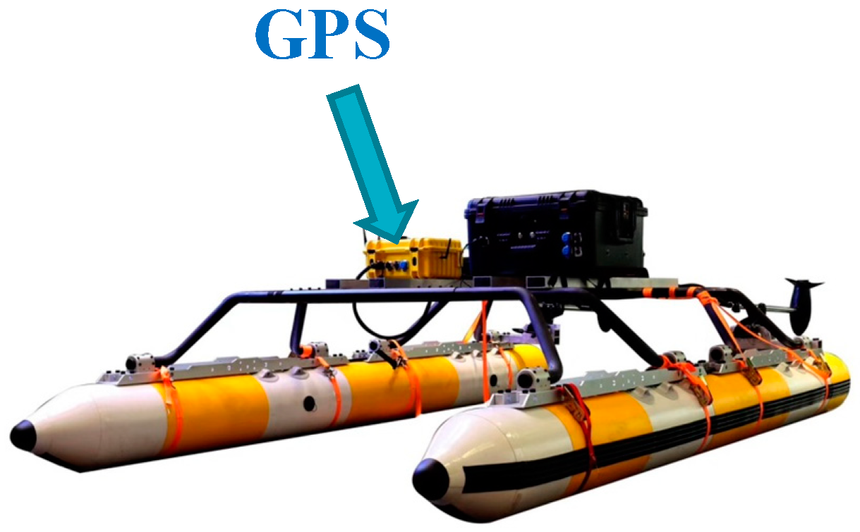
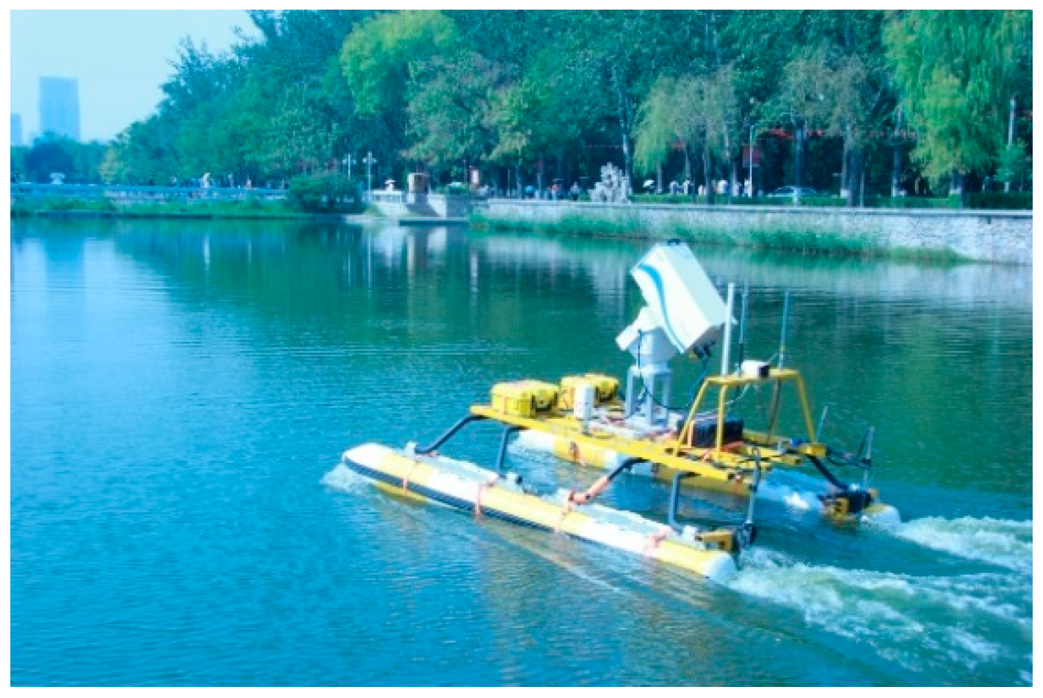
2.2. Model Validation

The application of the BNSD was verified by using a study object named Dolphin-I. The advance distance and tactical diameter of the USV were measured by field tests. Before the test, the GPS equipment was installed on the vehicle for real-time positioning and for obtaining the turning test data. The positioning accuracy error of the GPS was less than 1.0 m; the installation of the GPS antenna is shown in Figure 3. In the test, the USV was kept on a fixed course until reaching a constant velocity, and then steered with the maximum rudder angles to the port or starboard, respectively, and kept to them. The average values of AD and DT in the multiple tests were taken as the turning data of the USV. The experiment was conducted in Jingye Lake, Tianjin University (see Figure 4). This lake is a calm water lake, without influence of strong waves and currents. The obtained AD and DT were substituted into Equations (2)–(6) to complete the calculation of the domain size. The parameters of Dolphin-I and the turning test data are shown in Table 1.
In order to calculate the domain size, some parameters were assigned. The value of ∆U/U0 in head-on was 0.5, the value of the relative angle α in crossing was 60° and the value of ∆U/U0 in overtaken was −0.5. Then the domain size of each encounter situation was calculated, as seen in Figure 5.
The reasonable spatial space according to various encounter situations can be given by the BNSD. In each situation, Rfore and Rstarb are the longer ones of the four radii and the Raft is usually the shortest, because ships should comply with the COLREGs to steer to starboard to avoid collision [11] in the majority of the cases, thus the sufficient space in fore and starboard should be maintained for collision avoidance and emergency actions. After transiting, the potential jeopardy of the ships and the obstacles to own USV is decreased; the Raft is relatively shorter. In addition, the safety domain that is needed for crossing is the largest. This is because the encounters involved in crossing are the most complicated in the four encounter situations, including small-angle crossing, vertical crossing and large-angle crossing. In the situation of being overtaken, own ship should maintain the course and speed. If necessary, own ship shall slow down the speed and narrow the NSD to make room for the overtaking ship. Therefore, the size of the safety domain in the overtaken situation is small.

3. Extraction of the Essential Factors of Navigation Safety

During the voyage, the lengths of Rfore, Raft, Rstarb and Rport in the navigation safety domain are regulated by various factors and are time-varying. It is obvious that the influence weight of each factor is different, which needs to be determined by further study. The rough set proposed by the Polish mathematician Z. Pawlak [40] is employed to analyze the factors that could affect the size of the navigation safety domain and extract the crucial factors with greater importance for the construction of a DNSD. Rough set theory is a mathematical method for studying incomplete and uncertain knowledge [40,41]; the importance of the influencing factors can be evaluated without a large amount of experimental data. By using the concepts of lower and upper approximation, knowledge hidden in information systems can be unraveled and expressed in the form of decision rules [42].

3.1. Factors Affecting the Size of the Navigation Safety Domain

In order to avoid repetition, factors that were involved in the BNSD were not considered in the construction of the DNSD. Other factors that affected the domain size were divided into navigation factors (NF), traffic factors (TF) and environmental factors (EF); their subsets are defined, respectively, in Table 2.

3.2. Factor Importance

Let S = ( U , A , V , f ) be a complete information system where U is a non-empty set, which is called the universe. A is a non-empty finite set of attributes, A = C D , C D . C is the condition attribute set with the factors affect the size of NSD. D is the decision attribute set with the size level of NSD. V is the value range of attribute. f is the functional relation set between U and A. R is the equivalent relation on U, defined as
I N D ( R ) = { ( x , y ) ( U , U ) | a A , f ( x , a ) = f ( y , a ) }
U / I N D ( R ) is the division of U; elements in it are called the equivalent class.
The relation between the factors in Table 2 and the size of the NSD is hard to directly demonstrate and quantitatively express in the decision attribute set, and the essence of the safety domain is the real-time safety evaluation during the navigation, which is reflected in the form of an “inviolable area”. It is stipulated that the safety levels are “safe”, “relatively safe”, “medium”, “relatively dangerous” and “dangerous”. Correspondingly, the higher the degree of safety, the smaller the inviolable area; the higher the degree of danger, the larger the inviolable area. Therefore, the analogy of “size of the navigation safety domain” can be transferred to the “degree of navigation safety”; the mapping between the level of navigation safety and the size of an NSD can be constructed. Let D be the decision attribute set of a rough set; that is, the size of the navigation safety domain. H, is the navigation safety level set. The navigation safety level is defined as the bijection of the safety domain size, where each safety level corresponds to the unique safety domain size or the expansion degree in the BNSD; the mapping relation is shown in Figure 6.
The principles of the importance of the analysis of the factors are as follows:
(1) The discretization of influencing factors and the determination of navigation safety level. The discretization process of the data was carried out on the basis of its properties and objective attributes. For example, the "wind" can be discretized according to the speed level. Because of the mapping relation, the navigation safety level was used instead of the size of the NSD. The principle is that with the rise of the navigation safety level, the NSD narrows.
(2) Attribute value reduction. If I N D ( R ) = I N D ( R { r } ) , then r is an attribute that can be deducted in R. If it is independent, then P is said to be an attribute reduction of R. Taking the subset factors in Table 2 as condition attributes and the safety level of the USV as decision attributes, a decision table can be constructed and its attributes should be reduced for further steps.
(3) Calculation of the dependence of the navigation safety on the influencing factors. Let P and Q be subsets of condition attribute C and decision attribute D, respectively, and a be an arbitrary influencing factor, then the dependence of the navigation safety level on each influencing factor can be written as follows:
γ P ( Q ) = | P O S P ( Q ) | | U |
γ ( P { a } ) ( Q ) = | P O S ( P { a } ) ( Q ) | | U |
where POSP(Q) is the P positive region of Q and POS (P-{a})(Q) is the P-a positive region of Q. |U| denotes the basis width; that is, the number of factors contained in the theory domain.
(4) Calculation of attribute importance. The importance of an arbitrary impact factor is as follows:
S i g P Q ( a ) = γ P ( Q ) γ ( P { a } ) ( Q )
Because of the number of factors in the condition attributes and the degree of data dispersion are large, the factor importance in the subset of NF, TF and EF were evaluated separately, and then normalized according to the weight of each subset.
(5) Calculation of factor weights and selection of main factors. The importance of each factor was normalized, and the weight was obtained. The weight threshold was set to extract the main factors that have the greatest impact on the navigation safety of the USVs.
The influence factors were discretized and divided into five levels. Among them, the level with the smaller value tends to be more suitable for navigation of ships and needs a smaller safety domain, while the level with a larger value tends to be more unsuitable for navigation of ships or needs to increase the size of the safety domain.
K1 Taking the standard speed VS of USVs as the index, the velocity parameter can be discretized as 1 = (0,VS/4), 2 = (VS/4, VS/2), 3 = (VS/2,3 VS/4), 4 = (3VS/4, VS) and 5 = (VS,+∞).
K2 USVs shall be equipped with various equipment during operation and the maximum load capacity of the USV is T. The dispersion is 1 = (0,T/4), 2 = (T/4, T/2), 3 = (T/2,3T/4), 4 = (3T/4,T) and 5 = (T,+∞).
K3 Refers to the number of obstacles around the NSD, including static and moving obstacles. Take two obstacles as the interval, dispersed as 1 = (0,2), 2 = (2,4), 3 = (4,6), 4 = (6,8) and 5 = (8, +∞).
K4 DCPA refers to the distance to the closest point of approach between own ship and obstacles or other ships. In the COLREGs, it is necessary to give way when there is an overtaking situation, or when another ship is on the starboard side of own ship in a crossing situation. Therefore, in order to maximize the security, the Rport in the BNSD is taken as the dividing index and discretized as 1 = (Rport,+∞), 2 = (3Rport/4, Rport), 3 = (Rport/2, 3Rport/4), 4 = (Rport/4, Rport/2) and 5 = (0, Rport/4).
K5 With the interval of wind scale 1, it is divided into 1 = (1,2), 2 = (2,3), 3 = (3,4), 4 = (4,5) and 5 = (5, +∞).
K6 It is divided by wave height interval of 0.3 m and dispersed into 1 = (0.3,0.6), 2 = (0.6,0.9), 3 = (0.9,1.2), 4 = (1.2,1.5) and 5 = (1.5, +∞).
K7 The velocity interval of surface current is 0.3m/s, which is divided into 1 = (0.3,0.6), 2 = (0.6,0.9), 3 = (0.9,1.2), 4 = (1.2,1.5) and 5 = (1.5, +∞).
K8 The mean sea level to seabed at low tide is adopted and divided by an interval 0.5 m: 1 = (3.0, +∞), 2 = (2.5,3.0), 3= (2.0,2.5), 4 = (1.5,2.0) and 5 = (1.0, 1.5).
K9 Here, Rfore in the BNSD is adopted as the division index and the visibility range is divided into 1 = (5Rfore, +∞), 2 = (4Rfore, 5Rfore), 3 = (3Rfore, 4Rfore), 4 = (2Rfore, 3Rfore) and 5 = (Rfore, 2Rfore).
Similarly, the decision attributes that were discretized and grades 1–5 represented “safe", “relatively safe”, “medium”, “relatively dangerous” and “dangerous”. In the process of establishing the decision table, by changing the assignment of K1-K9 to represent different working conditions, the navigation safety level was based on the results obtained by the preliminary evaluation of the Delphi method [41,42]. In the process of data collection, the expert questionnaire method was adopted. The interviewees included engineers engaged in the research and development of USVs, captains and chief officers with practical collision avoidance experience and doctoral students with relevant research interests. After we made sure that they understand the purpose of this study, we asked them to fill in the questionnaire according to their own knowledge. The interviewees judged the navigation safety level of the USV according to the different working conditions composed of K1K9. These data were used to extract the essential factors which affect the size of navigation safety domain. After the equivalence attribute reduced, the decision table was obtained, see Table 3.
The importance of the factors in each subset is calculated by Equations (8)–(10), the results are shown in Figure 7 and the computation process is detailed in Supplementary Materials. It is indicated that the importance of the factors is not completely consistent before normalization, in which the instantaneous speed, the numbers of obstacles and the wave are the most significant factors in each subset with an importance of 0.625, 0.70 and 0.35, respectively. It reveals that the navigation safety of the USVs is dramatically affected by these three factors. According to the number of elements in each subset, the importance value of each factor was normalized with a weight of ω = (0.2, 0.3, 0.5). The results are given in Figure 8.
It can be seen that, after normalization, the number of obstacles, with an importance value of 0.21, strongly influences the navigation safety of ships. When the traffic conditions around the route are complicated, the USV should expand its own safety domain to ensure safety. In addition, the impact of waves, instantaneous speed, currents and winds on the safety domain is relatively big; the normalized importance value is 0.175, 0.125, 0.125 and 0.10, respectively. In turn, depth, visibility, DCPA and navigation load are less significant to the navigation safety of the USVs. The USV is a small-scale vessel with a shallow draft and hardly restricted by water depth. If the NSD is not applied, ships need to use the value of the DCPA to judge the possibility of a collision and need to change their course or speed to obtain a larger DCPA. If the judging of the collision avoidance time is based on whether the NSD is violated, the role of DCPA can be replaced. In other words, the critical value of the DCPA is the distance from the USV to the boundary of the NSD.

3.3. Condition Attribute Set Reduction

In the construction of the DNSD, in order to highlight the influence of the essential factors on the domain size, the condition attribute set is reduced by setting an importance threshold of 0.10. The factors below the threshold in Figure 8 are reduced, and the factor set after the reduction is Ω = {K3, K6, K1, K7, K5}. The factors vary within the range narrowed in K1K9. When any of the factors is extremely severe, the USV has a higher risk of navigation. When the working condition value of all the factors is "5", it is impossible for the USVs to navigate. The importance of the factors in Ω was normalized again to obtain the results shown in Figure 9. After re-normalization, the factor weight vector τ = (0.28, 0.24, 0.17, 0.17, 0.14) and the size relation among the factors have not changed. It should be noticed that the conditional attribute factors were reduced to simplify the model and eliminate the excess in the domain size that was caused by the superposition of factors.

4. Construction of the Dynamic Navigation Safety Domain

Based on the above research, this section will construct a model for USVs that can dynamically adjust the boundary of the safety domain according to the change in the navigation scene. The DNSD was formed by fully considering the expansion effect of various factors on the BNSD. In the relative researches, scholars generally use the method of fuzzy mathematics and membership function [22,33,43,44,45] to study the influence of various factors on navigation safety. In this paper, the influence of each factor on the NSD was given by an extension function. The constructed DNSD shall meet the following requirements:
(1) The DNSD should include the extension function of various factors on the navigation safety domain and quantitatively expand the safety domain boundary by analyzing the actual impact of different factors on the USV.
(2) The DNSD should have good space utilization while ensuring safety and should not blindly expand the domain scope and cause unnecessary collision avoidance actions of the USV. For example, the change of a certain factor should cause the change of a corresponding semi-axial scale in the DNSD, rather than simply changing as a whole.
(3) The size of the DNSD is time-varying or changing elastically with different working conditions.
The DNSD was built by using the main factors extracted in Section 3, which includes the BNSD and the extension function of the factors in Ω. The specific form is as follows:
D N S D ( t ) = f { B N S D [ ( x , y ) , Q ] ξ ( Ω ) τ }
ξ ( Ω ) = { ζ ( Ω N o B ) , ζ ( Ω w a v e ) , ζ ( Ω s p e e d ) , ζ ( Ω c u r r e n t ) , ζ ( Ω w i n d ) }
τ = [ 0.28 , 0.24 , 0.17 , 0.17 , 0.14 ]
where the ξ(Ω) is the extension function of main factors to the BNSD, which contains the sub-extension functions ζ(·) of each factor; τ is the weight vector.

4.1. Numbers of Obstacles

The obstacle is the most significant factor affecting the safety of USVs in Ω, but it does not mean that the collision will inevitably occur if the traffic flow is dense. For example, in channels with traffic separation schemes, even a relatively large number of ships create quite an insignificant deterioration of the safety level if all the ships proceed along a fairway, one following the other. Therefore, this extension function is more suitable for chaotic traffic flow or the water area without an obvious channel. Unlike manned ships, the majority of unmanned surface vehicles are not equipped with AIS systems. USVs usually work with radars, sonars and machine vision to obtain the azimuth, the distance as well as the quantity of ships and obstacles nearby [46]. In order to build a universal model of the obstacle extension function, we took the length and breadth of the USV and the number of obstacles in multiple bearings as parameters, and established the sub-extension function ζNoB).
ζ ( Ω N o B ) : { Δ R f o r e = n θ L 0 < θ 90 /   270 < θ 360 Δ R a f t = n θ L 90 < θ 270 Δ R s t a r b = n θ B 0 < θ 180 Δ R p o r t = n θ B 180 < θ 360
in which ∆Rfore, ∆Raft, ∆Rstarb and ∆Rport are the expansion values of the BNSD in each semi-axis direction, respectively; and nθ is the number of obstacles in the direction of θ, including moving obstacles and static obstacles. With the increase in the number of obstacles, the navigation safety domain expands linearly on the basis of the original model. At the same time, the sub-model can expand the corresponding semi-axis according to the bearing of the obstacles, which ensures the space utilization in other directions.

4.2. Wave

The waves have impact on the motion state of the USVs, which will weaken the navigation stability and produce deviations from the intended course. For USVs and other surface equipment with small dimensions and a low center of gravity, they can be approximately regarded as a particle moving in the waves and the displacements in the vertical and horizontal directions are as follows [47,48]:
{ Δ z ( t ) = m = 1 M A m cos [ 2 π ω m t + ϕ m ] Δ h ( t ) = m = 1 M A m sin [ 2 π ω m t + ϕ m ]
where the ∆z and ∆h are the displacements in the vertical and horizontal directions, respectively; and Am, ωm and ϕm are the amplitude, frequency and phase of the mth vibration wave, respectively. Here, only the influence of horizontal displacement on the size of the NSD is considered, and the sub-extension function ζwave) of the waves on the NSD is defined as follows:
ζ ( Ω w a v e ) : { Δ R f o r e = Δ h ( t ) cos φ 90 < φ 270 Δ R a f t = Δ h ( t ) cos φ 0 < φ 90 /   270 < φ 360   Δ R s t a r b = Δ h ( t ) sin φ 180 < φ 360 Δ R p o r t = Δ h ( t ) sin φ 0 < φ 180
in which φ is the direction of the waves relative to the USVs. Similarly, the sub-model can expand the corresponding semi-axis according to the relative direction between the waves and the USV.

4.3. Instantaneous Speed

It is generally believed that with an increase in speed, the size of the safety domain should be appropriately expanded. According to the model proposed by Jia [49], the major and minor semi-axis dimensions of the safety domain are proportional to the speed when the mass and maneuverability of the ship are invariant. We adopted the abovementioned model and the approximate relation of each semi-axis length in the Goodwin [16] model to give the sub-extension function ζspeed).
ζ ( Ω s p e e d ) : { Δ R f o r e = 1 2 L K s V I Δ R a f t = 2 5 L K s V I Δ R s t a r b = 1 2 B K s V I Δ R p o r t = 1 4 B K s V I
where Ks is the speed proportional factor; here Ks = 1. VI is the instantaneous speed or the average velocity in a shorter time of the USV.

4.4. Current

Since the application of ARPA (Automatic Radar Plotting Aids) radar, the impact of currents on ships’ navigation has been greatly weakened. However, due to the fact that the radars carried by USVs are mostly used for obstacle detection and without the ARPA function, this correction still should be considered. The current in the sea is usually non-uniform, but due to the small dimension of the USV, it can be considered that the flow field does not change in the range of ship length. Under the condition that the ship navigates in the uniform flow field, the impact of the current only changes the translational speed of the ship [50]. Therefore, only the drift of the USV in the horizontal plane is considered in this study. When the current velocity is vc, the yaw distance of the USV can be written as follows:
s c = v c t c
The sub-extension function ζcurrent) is given as follows:
ζ ( Ω c u r r e n t ) : { Δ R f o r e = s c cos δ 0 < δ 90 /   270 < δ 360 Δ R a f t = s c cos δ 90 < δ 270 Δ R s t a r b = s c sin δ 0 < δ 180 Δ R p o r t = s c sin δ 180 < δ 270
where vc is the current velocity; tc is the time required for the USV to overcome the current velocity and return to the original route; and δ is the direction of the current relative to the USV.

4.5. Wind

The influence of the wind on the USVs is the drift to the downwind, which brings great hazard to the navigation or collision avoidance. With the increase in wind speed and the change of wind angle, the values of Rfore, Raft, Rstarb and Rport in the NSD should expand accordingly. In this study, we only considered the drift in the horizontal plane of the USV in wind and ignored the interaction between the wind and the hull. The drifting speed of the USV in the crosswind is as follows [50]:
v w = ρ a ρ C a Y C H Y A L L d V a exp ( 0.14 V s )
The drift distance to the downwind is
s w = v w t w
where ρa is the air density and ρ is the seawater density; AL is the projected area of the USV above the water surface; d is the draft; CaY is the crosswind pressure coefficient; CHY is the longitudinal hydrodynamic coefficient; Va is the relative wind speed, which is approximately equal to the actual wind speed; and tw is the time required for the USV to overcome the impact of the wind and return to its original route. Then the sub-extension function ζwind) of each semi-axis under the effect of wind force can be obtained.
ζ ( Ω w i n d ) : { Δ R f o r e = s w cos α 90 < α 270 Δ R a f t = s w cos α 0 < α 90 /   270 < α 360   Δ R s t a r b = s w sin α 180 < α 360 Δ R p o r t = s w sin α 0 < α 180

5. Case Studies and Discussion

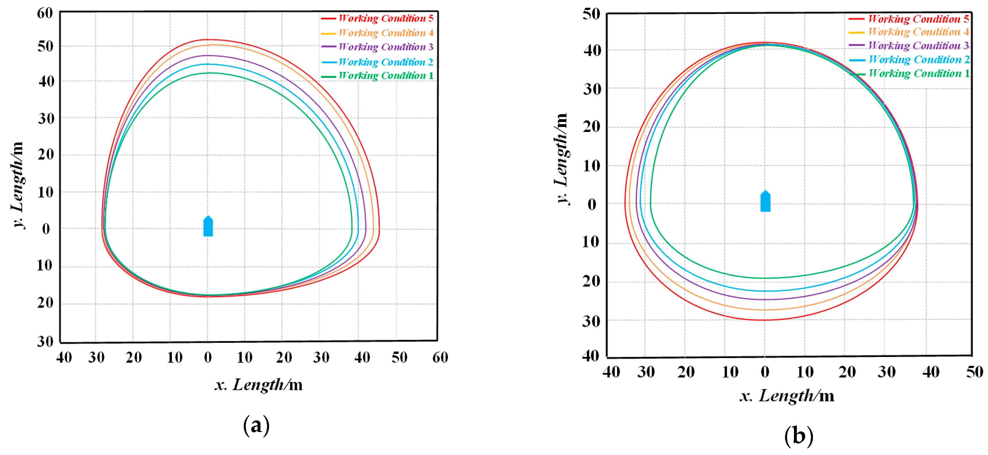
5.1. Simulation of DNSD in Various Working Conditions

Taking Dolphin-I as an example, the validity of the DNSD in various working conditions is discussed. In the numerical simulations, the elements in Ω vary from low to high levels; the changing trends of Rfore, Raft, Rstarb and Rport in the DNSD were calculated. In order to study the influence of the environmental changes on the NSD, two groups of angles and five working conditions were employed, and are given in Table 4.
One of the angle groups is collide/drift in the starboard and fore directions induced by obstacles, waves, winds and currents; the other is the port and aft directions. The five working conditions are the gradual increase of the number of obstacles and the speed and the drift distance of the USVs caused by the waves/winds/currents. The variation in domain radius in head-on, crossing, overtaking and overtaken under the two groups of angles and working conditions were plotted as curves, respectively, as shown in Figure 10, Figure 11, Figure 12 and Figure 13. When USVs are in the head-on situation with other vessels during the voyage, under the first angle groups and with the increase in the working condition level, the DNSD will expand the starboard and fore domain boundary, as shown in Figure 10a. Among them, the maximum values of Rfore and Rstarb are 50.3 m and 43.2 m; the rates are 0.24. The length of Raft and Rport remained basically unchanged. Under the second angle groups, the DNSD expands Raft and Rport to 30.1 m and 33.9 m at a rate of 0.53 and 0.26 on the basis of BNSD; the lengths of Rfore and Rstarb remain basically the same, as shown in Figure 10b.
In the case of crossing, the change in the DNSD is similar to that of the head-on, and the radius length in the corresponding directions can be adjusted according to the working conditions. Under the first angle groups, the maximum values of Rfore and Rstarb are 52.7 m and 46.6 m, as shown in Figure 11a. In the other angle groups, the maximum values of Raft and Rport are 30.1 m and 36.4 m, as shown in Figure 11b.
When overtaking other vessels, own USV is the give-way ship and needs to pay close attention to the movements of the stand-on vessels. Under the first angle groups, the Rfore and Rstarb in the DNSD increases to 43.3 m at the rate of 0.29 and 0.24, respectively, as shown in Figure 12a. In the second angle groups, the Raft and Rport increase to 30.1 m and 33.9 m at rate of 0.53 and 0.26, as shown in Figure 12b, in which the length of Rport is larger than Rfore. This is because when ships fulfill the requirements of the COLREGs, the majority of overtaking vessels usually overtake from the starboard of the overtaken ships. When drifting to the stand-on ships under the influence of various factors, the DNSD can expand the port and aft boundaries to make own USV avoid a collision earlier.
With the rise in the working condition level, the rate of the NSD in the overtaken situation increases faster than that of other encounter situations. Under the first angle groups, the Rfore and Rstarb in the DNSD increase to 36.3 m and 38.1 m at the rate of 0.37 and 0.29, respectively, as shown in Figure 13a. Under the second angle groups, the Raft and Rport increased to about 30.0 m at rate of 0.53 and 0.31, as shown in Figure 13b. As mentioned before, the size of the BNSD in the case of being overtaken is relatively small; when the collision risk due to out of control ships occur in the process of being overtaken, the DNSD will rapidly expand to the extent that there is enough space for the USVs to take collision avoidance measures.
It can be seen that the size of the DNSD enlarges with an escalation in the working condition level. Considering the demand of “early”, “large”, “wide” and “clear” in the COLREGs [11], it is necessary to set enough space around the USVs to avoid collision. When there are obstacles in the fore/starboard of the USVs, or drift into fore/starboard by the influence of waves, winds and currents, the length of Rfore and Rstarb of the DNSD increase faster, while the length of Raft and Rport change less. On the contrary, the length of the Raft and Rport increase faster and that of the Rfore and Rstarb vary less; this shows that the DNSD can adjust the domain boundaries according to the actual situation.

5.2. Comparison Between the DNSD and Other Ship Domains

The safety of the DNSD was verified through comparing it with the Fujii and Coldwell ship domains.
Remark 1: Fujii obtained the approximate relation between the size of the NSD and the ship length by statistical methods. Here, 10 groups’ data that were close to the size of USVs in the Fujii observation samples were selected, and the domain size of Dolphin-I was calculated by linear interpolation. The results were divided into the minimum model, average model and maximum model, and are shown in Table 5.
Remark 2: Coldwell put forward the ship domain in restricted water and gave the relation between the radius of the ship domain and ship length in case of head-on and overtaking scenarios. It was applied in Dolphin-I and the results are shown in Table 6.
The DNSD was involved in different encounter situations. Compared with the Fujii model, in head-on, crossing and overtaking situations, the target ship will firstly violate the boundary of the DNSD, and then infringe upon the Fujii ship domain, as shown in Figure 14a–c. When the target ship is overtaking own USV, the domain of the Max and Ave models of the Fujii domain will be firstly violated, as shown in Figure 14d. This proves that during the voyage of a manned ship, the navigators may pay more attention to the threat of ships from aft directions.
In the comparison with the Coldwell model, the target ships will infringe upon the boundary of the DNSD earlier than that of the Coldwell model, as shown in Figure 15a,b. The size of the Fujii model and Coldwell model is smaller than the DNSD in the majority of bearings; this is consistent with the conclusion of Wang et al. [39] that the Fujii model and the Coldwell model are relatively small and hazardous for a ship’s collision avoidance actions. The reason is that the navigators in manned ships can judge whether there is a collision risk and take timely measures according to their own experience and real-time watch keeping. It is possible that even if the NSD has been violated, they can still rely on the navigator’s "good seamanship" to avoid collision. In addition, the aspect ratio of the Fujii model and Coldwell model are larger than that of the DNSD, which is consistent with the fact that the aspect ratio of large ships is larger than that of USVs. This will cause an insufficient length of Rstarb and Rport in the safety domain of manned ships, so it is necessary to increase the scope of the safety domain horizontally. The DNSD can make up for the existing shortage and dynamically adjust the boundary with a change in the working conditions and encounter situations, which has a good space utilization effect.

6. Conclusions

This paper carried out a dynamic navigation safety domain for USVs, and the extension functions of the domain boundary factors were studied. A catamaran USV named Dolphin-I was taken as the study object to verify the model in different working conditions and encounter situations. The following conclusions are drawn:
(1)
The DNSD can delimit the safety space to be maintained in voyage according to the geometric properties, advance distance and tactical diameter of the USVs, and it can effectively distinguish different encounter situations.
(2)
Under various working conditions, the DNSD can adjust the spatial scale in the corresponding bearing in allusion to the change of factors, rather than expanding the scale range in all directions.
(3)
Compared with the Fujii model and the Coldwell model, it is found that the ship domains of the manned ship pays more attention to the rear ship; the safety space left in the port and starboard side is obviously insufficient for USVs. The DNSD can provide a larger safety area for the USVs’ action of collision avoidance.
The dynamic navigation safety domain is the foundation of collision avoidance and path planning in USVs. In further research, the DNSD can be used to study the navigation decision-making and local collision avoidance of USVs.

Supplementary Materials

The following are available online at https://www.mdpi.com/2077-1312/8/4/264/s1.

Author Contributions

The manuscript was written by J.Z. and C.W.; all authors discussed the original idea; conceptualization, J.Z. and C.W.; methodology, J.Z. and C.W.; software, Z.J.; validation, Z.J., C.W. and A.Z.; formal analysis, C.W. and A.Z.; investigation, J.Z.; resources, A.Z.; data curation, A.Z.; writing—original draft preparation, J.Z. and C.W.; writing—review and editing, C.W. and A.Z.; visualization, J.Z. and C.W.; supervision, A.Z.; project administration, A.Z.; funding acquisition, A.Z. All authors have read and agreed to the published version of the manuscript.

Funding

This research was funded by National Key Research and Development Program of China, grant number 2018YFC1407400.

Conflicts of Interest

The authors declare no conflict of interest.

Abbreviations

AISAutomatic Identification System
ADAdvance Distance
ARPAAutomatic Radar Plotting Aids
BNSDBasic Navigation Safety Domain
COLREGsInternational Regulations for Preventing Collisions at Sea
DCPADistance to Closest Point of Approach
DNSDDynamic Navigation Safety Domain
DTTactical Diameter
GPSGlobal Satellite Positioning System
NSDNavigation Safety Domain
QSD Quaternion Ship Domain
USVsUnmanned Surface Vehicles

References

  1. Liu, Z.; Zhang, Y.; Yu, X.; Yuan, C. Unmanned surface vehicles: An overview of developments and challenges. Annu. Rev. Control. 2016, 41, 71–93. [Google Scholar] [CrossRef]
  2. Thompson, F.; Guihen, D. Review of mission planning for autonomous marine vehicle fleets. J. Field Robot. 2018, 36, 333–354. [Google Scholar] [CrossRef]
  3. Zereik, E.; Bibuli, M.; Mišković, N.; Ridao, P.; Pascoal, A.M. Challenges and future trends in marine robotics. Annu. Rev. Control. 2018, 46, 350–368. [Google Scholar] [CrossRef]
  4. Wang, H.; Guo, F.; Yao, H.; He, S.; Xu, X.; Wang, F.H.; Guo, S.F.; Yao, T.H.; He, F.S.; Xu, F.X. Collision Avoidance Planning Method of USV Based on Improved Ant Colony Optimization Algorithm. IEEE Access 2019, 7, 52964–52975. [Google Scholar] [CrossRef]
  5. Zhang, J.; Zhang, D.; Yan, X.; Haugen, S.; Soares, C.G. A distributed anti-collision decision support formulation in multi-ship encounter situations under COLREGs. Ocean Eng. 2015, 105, 336–348. [Google Scholar] [CrossRef]
  6. Wang, Y.; Yu, X.; Liang, X.; Li, B. A COLREGs-based obstacle avoidance approach for unmanned surface vehicles. Ocean Eng. 2018, 169, 110–124. [Google Scholar] [CrossRef]
  7. Zhang, L.; Liu, Z.; Papavassiliou, C.; Liu, S. Formation path control method for group coordination based on fuzzy logic control method. Clust. Comput. 2017, 21, 855–868. [Google Scholar] [CrossRef]
  8. Singh, Y.; Sharma, S.; Sutton, R.; Hatton, D.; Khan, A. A constrained A* approach towards optimal path planning for an unmanned surface vehicle in a maritime environment containing dynamic obstacles and ocean currents. Ocean Eng. 2018, 169, 187–201. [Google Scholar] [CrossRef] [Green Version]
  9. Deng, Y.; Zhang, X.; Im, N.; Zhang, G.; Zhang, Q. Model-Based Event-Triggered Tracking Control of Underactuated Surface Vessels With Minimum Learning Parameters. IEEE Trans. Neural Netw. Learn. Syst. 2019, 1–14. [Google Scholar] [CrossRef]
  10. Zhao, H.; Zhang, X.; Han, X. Nonlinear control algorithms for efficiency-improved course keeping of large tankers under heavy sea state conditions. Ocean Eng. 2019, 189, 1–7. [Google Scholar] [CrossRef]
  11. IMO. Convention on the International Regulations for Preventing Collisions at Sea. 1972. Available online: http://www.imo.org/en/About/Conventions/ListOfConventions/Pages/COLREG.aspx (accessed on 7 January 2020).
  12. Kuwata, Y.; Wolf, M.T.; Zarzhitsky, D.; Huntsberger, T.L. Safe Maritime Autonomous Navigation With COLREGS, Using Velocity Obstacles. IEEE J. Ocean. Eng. 2013, 39, 110–119. [Google Scholar] [CrossRef]
  13. Fujii, Y.; Tanaka, K. Traffic Capacity. J. Navig. 1971, 24, 543–552. [Google Scholar] [CrossRef]
  14. Song, L.; Su, B.Y.; Dong, C.Z.; Shen, D.W.; Xiang, E.Z.; Mao, F.P. A two-level dynamic obstacle avoidance algorithm for unmanned surface vehicles. Ocean Eng. 2018, 170, 351–360. [Google Scholar] [CrossRef]
  15. Szlapczynski, R.; Szłapczyńska, J. Review of ship safety domains: Models and applications. Ocean Eng. 2017, 145, 277–289. [Google Scholar] [CrossRef]
  16. Goodwin, E.M. A Statistical Study of Ship Domains. J. Navig. 1975, 28, 328–344. [Google Scholar] [CrossRef] [Green Version]
  17. Davis, P.V.; Dove, M.J.; Stockel, C.T. A Computer Simulation of Marine Traffic Using Domains and Arenas. J. Navig. 1980, 33, 215–222. [Google Scholar] [CrossRef]
  18. Davis, P.V.; Dove, M.J.; Stockel, C.T. A Computer Simulation of Multi-Ship Encounters. J. Navig. 1982, 35, 347–352. [Google Scholar] [CrossRef]
  19. Coldwell, T.G. Marine Traffic Behaviour in Restricted Waters. J. Navig. 1983, 36, 430–444. [Google Scholar] [CrossRef]
  20. Kijima, K.; Furukawa, Y. Automatic collision avoidance system using the concept of blocking area. IFAC Proc. Vol. 2003, 36, 223–228. [Google Scholar] [CrossRef]
  21. Wang, N. An Intelligent Spatial Collision Risk Based on the Quaternion Ship Domain. J. Navig. 2010, 63, 733–749. [Google Scholar] [CrossRef]
  22. Wang, N. A Novel Analytical Framework for Dynamic Quaternion Ship Domains. J. Navig. 2012, 66, 265–281. [Google Scholar] [CrossRef] [Green Version]
  23. Dinh, G.H.; Im, N. The combination of analytical and statistical method to define polygonal ship domain and reflect human experiences in estimating dangerous area. Int. J. E-Navig. Marit. Econ. 2016, 4, 97–108. [Google Scholar] [CrossRef] [Green Version]
  24. Goerlandt, F.; Montewka, J.; Zhang, W.; Kujala, P. An analysis of ship escort and convoy operations in ice conditions. Saf. Sci. 2017, 95, 198–209. [Google Scholar] [CrossRef]
  25. Zhou, D.; Zheng, Z. Dynamic Fuzzy Ship Domain Considering the Factors of Own Ship and Other Ships. J. Navig. 2018, 72, 467–482. [Google Scholar] [CrossRef]
  26. Zhang, L.; Meng, Q. Probabilistic ship domain with applications to ship collision risk assessment. Ocean Eng. 2019, 186, 106130. [Google Scholar] [CrossRef]
  27. Szlapczynski, R.; Szłapczyńska, J. A Target Information Display for Visualising Collision Avoidance Manoeuvres in Various Visibility Conditions. J. Navig. 2015, 68, 1041–1055. [Google Scholar] [CrossRef]
  28. Szlapczynski, R.; Krata, P.; Szłapczyńska, J. Ship domain applied to determining distances for collision avoidance manoeuvres in give-way situations. Ocean Eng. 2018, 165, 43–54. [Google Scholar] [CrossRef]
  29. Rawson, A.; Rogers, E.; Foster, D.; Phillips, D. Practical Application of Domain Analysis: Port of London Case Study. J. Navig. 2013, 67, 193–209. [Google Scholar] [CrossRef]
  30. Liu, J.; Zhou, F.; Li, Z.; Wang, M.; Liu, R.W. Dynamic Ship Domain Models for Capacity Analysis of Restricted Water Channels. J. Navig. 2015, 69, 481–503. [Google Scholar] [CrossRef] [Green Version]
  31. Bakdi, A.; Glad, I.K.; Vanem, E.; Engelhardtsen, Ø. AIS-Based Multiple Vessel Collision and Grounding Risk Identification based on Adaptive Safety Domain. J. Mar. Sci. Eng. 2019, 8, 5. [Google Scholar] [CrossRef] [Green Version]
  32. Szlapczynski, R.; Szłapczyńska, J. An analysis of domain-based ship collision risk parameters. Ocean Eng. 2016, 126, 47–56. [Google Scholar] [CrossRef]
  33. Szlapczynski, R.; Niksa-Rynkiewicz, T. A Framework of A Ship Domain-Based Near-Miss Detection Method Using Mamdani Neuro-Fuzzy Classification. Pol. Marit. Res. 2018, 25, 14–21. [Google Scholar] [CrossRef] [Green Version]
  34. Tam, C.; Bucknall, R.; Greig, A. Review of Collision Avoidance and Path Planning Methods for Ships in Close Range Encounters. J. Navig. 2009, 62, 455–476. [Google Scholar] [CrossRef]
  35. Li, J.; Wang, H.; Zhao, W.; Xue, Y. Ship’s Trajectory Planning Based on Improved Multiobjective Algorithm for Collision Avoidance. J. Adv. Transp. 2019, 2019, 1–12. [Google Scholar] [CrossRef]
  36. Liu, X.; Li, Y.; Zhang, J.; Zheng, J.; Yang, C. Self-Adaptive Dynamic Obstacle Avoidance and Path Planning for USV Under Complex Maritime Environment. IEEE Access 2019, 7, 114945–114954. [Google Scholar] [CrossRef]
  37. Sun, X.; Wang, G.; Fan, Y.; Mu, D.; Qiu, B. Collision Avoidance of Podded Propulsion Unmanned Surface Vehicle With COLREGs Compliance and Its Modeling and Identification. IEEE Access 2018, 6, 55473–55491. [Google Scholar] [CrossRef]
  38. Lyu, H.; Yin, Y. COLREGS-Constrained Real-time Path Planning for Autonomous Ships Using Modified Artificial Potential Fields. J. Navig. 2018, 72, 588–608. [Google Scholar] [CrossRef]
  39. Wang, N.; Meng, X.; Xu, Q.; Wang, Z. A Unified Analytical Framework for Ship Domains. J. Navig. 2009, 62, 643–655. [Google Scholar] [CrossRef]
  40. Pawlak, Z. Rough sets. Int. J. Parallel Program. 1982, 11, 341–356. [Google Scholar] [CrossRef]
  41. Yang, L.; Zhang, X.; Xu, W.; Sang, B. Multi-granulation Rough Sets and Uncertainty Measurement for Multi-source Fuzzy Information System. Int. J. Fuzzy Syst. 2019, 21, 1919–1937. [Google Scholar] [CrossRef]
  42. Yeung, D.; Chen, D.; Tsang, E.; Lee, J.; Xizhao, W. On the generalization of fuzzy rough sets. IEEE Trans. Fuzzy Syst. 2005, 13, 343–361. [Google Scholar] [CrossRef]
  43. Zhao, Y.; Li, W.; Shi, P. A real-time collision avoidance learning system for Unmanned Surface Vessels. Neurocomputing 2016, 182, 255–266. [Google Scholar] [CrossRef]
  44. Zhou, X.; Huang, J.-J.; Wang, F.-W.; Wu, Z.-L.; Liu, Z.-J. A Study of the Application Barriers to the Use of Autonomous Ships Posed by the Good Seamanship Requirement of COLREGs. J. Navig. 2019, 72, 1–16. [Google Scholar] [CrossRef]
  45. Li, B.; Pang, F.-W. An approach of vessel collision risk assessment based on the D–S evidence theory. Ocean Eng. 2013, 74, 16–21. [Google Scholar] [CrossRef]
  46. Mousazadeh, H.; Jafarbiglu, H.; Abdolmaleki, H.; Omrani, E.; Monhaseri, F.; Abdollahzadeh, M.-R.; Mohammadi-Aghdam, A.; Kiapei, A.; Salmani-Zakaria, Y.; Makhsoos, A. Developing a navigation, guidance and obstacle avoidance algorithm for an Unmanned Surface Vehicle (USV) by algorithms fusion. Ocean Eng. 2018, 159, 56–65. [Google Scholar] [CrossRef]
  47. Mitsuyasu, H.; Tasai, F.; Suhara, T.; Mizuno, S.; Ohkusu, M.; Honda, T.; Rikiishi, K. Observation of the Power Spectrum of Ocean Waves Using a Cloverleaf Buoy. J. Phys. Oceanogr. 1980, 10, 286–296. [Google Scholar] [CrossRef]
  48. Gorman, R. Estimation of directional spectra from wave buoys for model validation. Procedia IUTAM 2018, 26, 81–91. [Google Scholar] [CrossRef]
  49. Jia, C.Y. Ship domain in congested water area. J. Dalian Marit Univ. 1989, 15, 15–19. [Google Scholar] [CrossRef]
  50. Hong, B.G. Ship Maneuvering, 1st ed.; Dalian Maritime University Press: Dalian, China, 2008; pp. 84–99. [Google Scholar]
Figure 1. Typical encounter situations as described in the International Regulations for Preventing Collisions at Sea (COLREGs): (a) Head-on; (b) Crossing (own USV is the stand-on vessel); (c) Crossing (own USV is the give-way vessel); (d) Overtaking; (e) Overtaken.
Jmse 08 00264 g001
Figure 2. Basic navigation safety domain.
Jmse 08 00264 g002
Figure 3. Installation of the GPS antenna.
Jmse 08 00264 g003
Figure 4. Turning test of Dolphin-I.
Jmse 08 00264 g004
Figure 5. Size of the basic navigation safety domain (BNSD) in various encounter situations.
Jmse 08 00264 g005
Figure 6. Mapping relation between the navigation safety level and the NSD.
Jmse 08 00264 g006
Figure 7. Factor importance in the different subsets.
Jmse 08 00264 g007
Figure 8. Factor importance after normalization.
Jmse 08 00264 g008
Figure 9. Factor importance after conditional attribute reduction.
Jmse 08 00264 g009
Figure 10. Radius changes of the dynamic navigation safety domain (DNSD) in the head-on situation: (a) Under the first angle groups; (b) Under the second angle groups.
Jmse 08 00264 g010
Figure 11. Radius changes of the DNSD in the crossing situation: (a) Under the first angle groups; (b) Under the second angle groups.
Jmse 08 00264 g011
Figure 12. Radius changes of the DNSD in the overtaking situation: (a) Under the first angle groups; (b) Under the second angle groups.
Jmse 08 00264 g012
Figure 13. Radius changes of the DNSD in the overtaken situation: (a) Under the first angle groups; (b) Under the second angle groups.
Jmse 08 00264 g013
Figure 14. The DNSD compared with the Fujii model in various encounter situations: (a) Head-on; (b) Crossing; (c) Overtaking; (d) Overtaken.
Jmse 08 00264 g014aJmse 08 00264 g014b
Figure 15. The DNSD model compared with the Coldwell model in head-on and overtaking encounter situations: (a) Head-on; (b) Overtaking.
Jmse 08 00264 g015
Table 1. Unmanned surface vehicle (USV) parameters and turning test data.
IndexParameters
Name Dolphin-I
TypeSurface Catamaran
Length (m)3.2
Breadth (m)2.2
Weight (kg)75.0
Draft (m)0.3–0.5
Driving ModeElectric Drive
Velocity (kn)5.0
Advance (m)16.5
Diameter Tactical (m)25.5
Table 2. Factors influencing the size of the NSD.
FactorsSubsetSymbol
NFInstantaneous SpeedK1
Navigation LoadK2
TFNumbers of ObstaclesK3
DCPAK4
EFWind K5
WaveK6
CurrentK7
DepthK8
VisibilityK9
Table 3. Table of navigation safety decision-making after the reduction of attribute values.
Serial NumberK1K2K3K4K5K6K7K8K9Navigation Safety Level
12312212232
23233241234
32142121314
42312322122
52212321121
61231342234
73252121115
82313211322
93231421514
103121312233
112321422353
124121232233
132113223222
141231214134
153142113314
163113322122
174431221323
183314113343
192335242235
202413313323
Table 4. Angle groups and working conditions.
Working
Conditions
K3K6/mK1/m·s−1K7/mK5/m
θ = 30°
θ = 240°
φ = 210°
φ = 60°
---
---
δ = 60°
δ = 210°
α = 240°
α = 30°
1nθ = 2h(t) = 0.3Vs = 1Sc = 1Sw = 2
2nθ = 4h(t) = 0.6Vs = 2Sc = 2Sw = 4
3nθ = 6h(t) = 0.9Vs = 3Sc = 4Sw = 6
4nθ = 8h(t) = 1.2Vs = 4Sc = 8Sw = 8
5nθ = 10h(t) = 1.5Vs = 5Sc = 10Sw = 10
Table 5. Dimensions of the Fujii model.
SizeRfore/mRaft/mRstarb/mRport/m
Min17.817.85.65.6
Ave21.321.39.89.8
Max24.924.913.913.9
Table 6. Dimensions of the Coldwell model.
Encounter
Situations
Rfore/mRaft/mRstarb/mRport/m
Head-on19.519.510.45.6
Overtaking19.219.29.79.7

