Article

Nature and Distribution of Beach Ridges on the Islands of the Greater Caribbean

by
Anna Lisa Cescon
1,
James Andrew Graham Cooper
1,2,* and
Derek W. T. Jackson
1,2
1
School of Geography and Environmental Sciences, University of Ulster, Coleraine BT52 1SA, Northern Ireland, UK
2
Geological Sciences, University of KwaZulu-Natal, Durban 3629, South Africa
*
Author to whom correspondence should be addressed.
J. Mar. Sci. Eng. 2024, 12(4), 565; https://doi.org/10.3390/jmse12040565
Submission received: 14 February 2024 / Revised: 21 March 2024 / Accepted: 21 March 2024 / Published: 27 March 2024
(This article belongs to the Special Issue Natural and Human Impacts in Coastal Areas)

Abstract

:
Beach ridges originate from various depositional processes and occur in a variety of settings. This paper assesses their nature and distribution on the islands of the Greater Caribbean based on a literature review and the identification of sites using Google Earth© 7.3 imagery. The morphological and orientation parameters were measured for each site, and a measure of storm density was developed. These were statistically analysed to develop a classification of beach ridge types. The results show a diversity of beach ridge systems, in terms of setting, morphology, composition and preservation. The presence or absence of an adjacent coral reef is a major differentiating element at the regional level. A regional beach ridge plain classification is proposed, including two main classes, marine beach ridges and river-associated beach ridges, with further sub-divisions based on exposure to hurricanes or hurricanes plus swell waves.

1. Introduction

Beach ridges are progradational coastal landforms composed of sand, gravel or boulders [1,2,3,4,5,6,7,8,9,10]. They reflect the spatio-temporal juxtaposition of sediment abundance, accommodation space and appropriate hydrodynamic conditions. Beach ridges are often developed under falling sea-level conditions (forced regression) or adjacent to large sediment sources (normal regression) [11]. A growing body of literature, however, also links beach ridge genesis to storm activity, of which they are sometimes thought to represent a sedimentary archive [1,4,5,12,13,14,15]. Where there is a fluvial sediment source, they may also preserve an archive of the past discharge conditions [16].
This article presents a regional overview of the nature and distribution of beach ridge landforms around the islands of the Greater Caribbean (Caribbean Sea, The Bahamas and Gulf of Mexico). Beach ridge plains are identified, and the essential characteristics of each example are documented in order to classify them and gain general insights into their nature, origin and spatial variability.
The work is based on a literature review, which is complemented and extended upon with a database of beach ridge landforms identified within Google Earth. It expands the global scale work of Scheffers et al. [7] that identified ten beach ridge plains in the Caribbean, each of which contained at least ten ridges. In the present study, all the beach ridge sites that contained two or more ridges were identified. The characteristics (morphology, setting, exposure and orientation) of the beach ridges are then explored. The proximity of a reef or a river is recorded to assess the potential sediment origin for the beach ridge sites, and the modes of the construction and preservation of beach ridges are also discussed. Finally, a regional classification of beach ridge landforms is presented.

2. Study Area

The Greater Caribbean area covers the Caribbean Sea islands plus an extension to the island bodies of the Bahamas Archipelago and the Gulf of Mexico basin (Table 1, adapted from Keegan et al. [17]). The study area extends from 10°02′ N to 27°24′ N and 59°26′ W to 89°47′ W. The Little Bahama Bank represents the northern limit of this study. The study area includes the islands in the region, but excludes the islands related to the American mainland (the Florida Keys and barrier island systems). The islands of Trinidad and Tobago represent the southeastern limit of the study [17].
The diversity of islands around the Caribbean Sea is due to a complex tectonic setting at the origin of the Greater and Lesser Antilles chains [18]. The area has a microtidal regime; the tidal range is ±0.5 m in Jamaica [19]. All the islands have a tropical or subtropical climate with dominant easterly winds, and the Caribbean Sea water temperature ranges from 15° to 30° [20]. Most of the islands are located between 10° N and 26° N and are therefore almost entirely contained within the tropics. The islands are affected by trade winds from the East, bringing regular rainfall, and distinct microclimates are developed according to the geographical setting of each island. The northernmost Bahamas islands have a distinctive rainfall regime compared to the southern Bahamas, with more precipitation (subtropical) found in the north where persistent easterly trade winds dominate [21].
The study area is annually crossed by multiple storm and hurricane tracks [22,23], and large Atlantic swell events have also been reported [24]. The area has been subject to several local and far-field tsunamis [25,26,27,28]. The Late Holocene sea level rise in the region decelerated ca. 7000 yrs BP, and a gradual rise is occurring at present [19,20,29]. No Holocene highstand of sea level has been reported, nor is any predicted by the GIA models [19] and consequently, the area is not subject to forced regression. From the beginning of the Holocene, the climatic conditions have varied due to the dependency of Caribbean Sea weather on the North Atlantic climatic system [20,22].
The shorelines of the islands around the Greater Caribbean provide an ideal location in which to investigate beach ridge variability in relation to controlling factors. They face in multiple different directions and are subject to different dynamic forcing [18,30]. There are also marked contrasts between high-altitude islands that have appreciable terrestrial sediment input [31] and low-altitude islands, where the fronting reef platforms constitute the only sediment source [18]. This creates the opportunity to study beach ridges with little to no continental influence.

3. Previous Studies of Greater Caribbean Beach Ridges

Tanner [9] noted that the shores of “relatively low-energy water bodies, such as the Gulf of Mexico […], the Caribbean Sea, the Gulf of Venezuela” are among the best areas to find beach ridges. However, only a limited number of sites have been investigated on its islands. A total of 51 beach ridge sites are reported in the literature on islands of the Greater Caribbean (Figure 1). These comprise both sand and coral rubble features, and in some instances, might include ridges of aeolian origin (foredunes) or ridges capped with aeolian sediment [32]. Scheffers et al. [7] identified ten beach ridge sites on the islands of the present study area in their global review of sites with more than 10 beach ridges. Four of these are in the Greater Antilles, two are in Cuba (Cayo Largo, north of Golfo de Cazonas), one is in the Dominican Republic (Laguna Salado), and one is in Puerto Rico (Quinta Esperanza). The remaining sites are situated in the Bahamas Archipelago. All these sites seem to comprise sandy beach ridges.
Several beach ridge sites have been documented in Barbuda [33]. They are associated either with present coastal processes or with Pleistocene sea-level highstands. “The Pleistocene Codrington Formation is a set of beach ridges of well-sorted cross-bedded calcarenites (…) overlain by hard crust” [34] p. 277). Palmetto Point is a Holocene beach ridge system that is presently accreting south of the point and eroding in the west. Another extensive beach ridge plain has been documented on the island of Anegada in the British Virgin Islands [28,35,36] The sandy beach ridges of Anegada were breached during historic tsunamis [28].
On the Scorpion Reef islands (also known as Alacran Reef), Folk and Robies [37] described a coarse clast beach ridges comprising 5–10 cm long sticks of Acropora cervicornis separated by swales topped by coarse carbonate sand. Similar coarse clast ridges on Bonaire, Jamaica and Isla de Mona (Puerto Rico) have been attributed to storm waves and or tsunami [27,38].
There are many studies on aeolianite in The Bahamas [39,40] and it is often poorly differentiated from beach ridge sediments. Almost all the islands, except West Andros and North Grand Bahamas, are covered by carbonate aeolianites arranged in ridges [41]. Brooke’s global review of carbonate aeolianites [40] identifies twelve sites in The Bahamas, but does not differentiate the Holocene and Pleistocene aeolianites. Recently, Buynevich et al. [42] okreported strandplains comprising 10–20 ridges on Eulethera and Little Exuma. The wave-lain component of these ridges have been identified in GPR records, and some erosional surfaces have been recorded.

4. Methodology

4.1. Google Earth© Mapping of Beach Ridge Systems

Beach ridge sites were identified and mapped around the islands of the Greater Caribbean using Google Earth© images available in 2016. Because image availability increases year on year, the list presented is unlikely to prove exhaustive.
For each island our investigation began in the northwest and progressed clockwise around the island, identifying sites with two or more ridges. The sites were saved in Google Earth© as a unique Keyhole Markup Language (*.kmz) file, and then converted in ArcGIS© to a shapefile (*.shp). Additional morphological data were compiled for each beach ridge site as a Google Earth©-derived shapefile. Each beach ridge site was assigned a unique identification code and was linked to an Excel 16.0 table, in which quantitative and qualitative data were compiled.

4.2. Descriptive Variables

Beach ridge plains were noted to be either contiguous with the modern shoreline or some distance landward. This difference was used to differentiate “modern” and “inactive” beach ridges, respectively.
At all sites objects of 5 m or less were identifiable. The greatest challenge lay in determining the boundaries between adjacent ridges, and hence, in counting the number of ridges. The minimum number of beach ridges present at each site was noted; without field investigation, only the largest features are visible, and smaller scale ridges are not discerned.
The orientation of the beach ridge plain (perpendicular to the ridge long axes) enables comparison with dominant directional winds and waves. The orientation was recorded as geographical angles (i.e., N = 0°; NE = 45°; E = 90°, etc.) and was used as a proxy for the incoming refracted wave direction relative to the beach ridge plain [43]. Given the degree of within site topographic variability, this was recorded in 45° increments. The geographic position and the orientation were associated each site either with waves from the Atlantic Ocean, the Gulf of Mexico or Caribbean Sea. We did not distinguish swash- and drift-aligned systems in this approach, but simply used them to determine the basin within which the waves originated.
The beach ridge sites were also categorised according to the presence/absence of an adjacent coral reef and the maximum distance from the shore to the outer edge of the reef. The presence of other potential sediment sources such as rivers were also noted as a qualitative variable.
For each beach ridge site, the North Atlantic storm event density was assessed using the Historical Hurricane Tracks dataset from 1851 to 2012 [44]. This dataset includes storms from “tropical depression” to “hurricane category 5” on the Saffir–Simpson scale [45]. The density of storms was measured on a grid of 30 × 30 km (900 km2). A spatial extraction from raster data to point features was performed in ArcGIS© to give a unique value of storm density for each beach ridge site. This variable was used as a proxy for the extreme wave environment at each beach ridge site.
The proximity of tsunami events or run up was at first investigated using the tsunami run-up and event datasets from the Global Historical Tsunami database [46]. However, this could not be plotted in a spatial form suitable for further analysis. The effect of tsunami waves is, however, discussed within the Dynamics and Extreme Events Section.

4.3. Statistical Analysis

Statistics were computed using the program R3.3.1 [47]. The distribution of beach ridges was assessed by principal component analysis (PCA) and classified using cluster analysis.
PCA assess the similarities and dissimilarities between two variables to assess the dependency of one variable on another (cause–effect link). It was conducted here on the variables that may have an impact on the beach ridge construction: the beach ridge number per site, geographical orientation, the presence of a reef in front of the beach ridge plain, the presence of a river close by, and storm density.
Cluster analysis was used to assess the similarity between beach ridge sites and to group them into a limited number of classes. Families of beach ridges were assessed in each cluster analysis to seek similarities in the beach ridge distribution. Initial analysis was performed on all the beach ridge sites identified and on the five variables cited above for PCA. Then, from the results of the first cluster analysis, three others were performed with a different combination of sites and variables. Of these three, two cluster analyses were performed using a different combination of variables, not taking into account the presence of a coral reef, but instead the distance from the shore to the outer edge of the reef. The number of beach ridge sites used in each of the four cluster analyses differs because of missing values for some variables or for the exclusion of some particular sites.
Further field investigations are needed to confirm our identification of “potential” Google Earth© beach ridge sites as “actual” beach ridge sites [48]. In the meantime, both are regarded as “beach ridge sites” in this text. The list of beach ridge sites presented in this work is unlikely to be exhaustive, but serves as an initial database to enable reflection on the nature and distribution of beach ridges on islands of the Greater Caribbean. It is noteworthy that some sites described in the literature were not identified in this approach (see below).

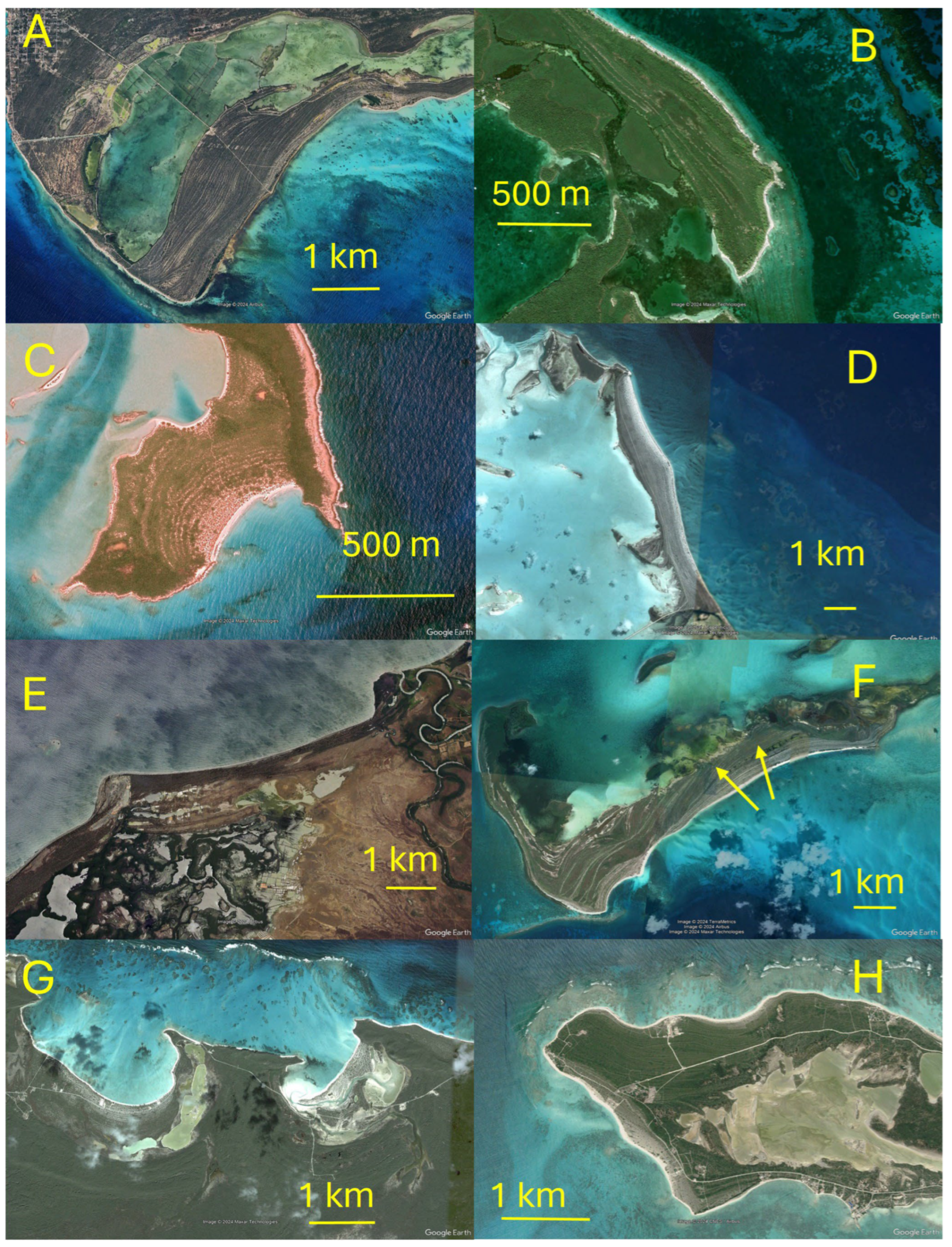
5. Results: Google Earth© Identification of Beach Ridges

There are several beach ridge-like features (strandplains, cheniers and foredune plains) [8]. The Google Earth© technique is unable to distinguish between these landforms, and examples of all are potentially included in our database.
From Google Earth©, a total of 250 beach ridge sites were identified in the study area (Figure 2). It was possible to definitively identify beach ridge sites in most instances due to the availability of high-resolution (<50 cm/pixel) satellite imagery around the islands. However, two sites (Bahamas_BR79 and Bahamas_InactiveBR5) were mapped with a lower quality of imagery. Twenty-nine of the two hundred and fifty sites identified have been described in the literature, whereas twenty-two sites described in the literature could not be identified in the available imagery (Figure 2). This appears to be due to the inadequate resolution of the imagery, or the surficial cover on the beachridges themselves (e.g., uniformly vegetated or heavily urbanised).
The highest density of beach ridge complexes occurs in the northwest, along the Atlantic-facing coasts of The Bahamas and northern Cuba (Figure 3). A smaller concentration facing the Caribbean is present on the southwest of Cuba. Sixteen beach ridge sites are present around Hispaniola, and two exist around the Ile de la Gonave (Haiti). Four sites were identified on Puerto Rico’s south coast. In the Lesser Antilles, beach ridge sites were only found on the islands of Anegada and Barbuda. In the Leeward Antilles, beach ridge sites were noted around the insular Federal dependencies of Venezuela. The Bahamas and Turks and Caicos carbonate groups contain a large number of beach ridge sites. None were identified on the Scorpion Reef, the only Gulf of Mexico island included in this study.
The beach ridge sites were grouped into two main categories: modern beach ridges (n = 228, e.g., Figure 3A) and inactive beach ridges (n = 22, e.g., Figure 3B). The inactive beach ridges are well vegetated, can be distant from the active coast, and can show signs of erosion (Figure 3B). Some of these show signs of aeolian or marine reworking. The inactive sites were later excluded from statistical analysis, as they do not directly relate to contemporary coastal processes and setting. The Pleistocene beach ridge plain of Barbuda represents one of the inactive sites.
The length and width of the beach ridge sites vary from decametres to several kilometres (Figure 3C,D). These parameters were not quantified in this study, but could yield important additional information in future works. Some beach ridge sites are constrained by rocky headlands in embayed beaches (Figure 3G); others are elongate linear features, such as linear beaches or barrier islands (Figure 3 A,D,F,H).
Sixteen of the beach ridge sites are situated near a river mouth (Figure 3E). They are situated along the coast of Cuba (five sites), Hispaniola (nine sites) and Puerto Rico (two sites). Five sites were adjacent to both the river and coral reefs. Geomorphologically, some beach ridge complexes form as spits, and the dominant longshore transport direction can be determined from the beach plain and spit development direction.
Where appropriate, the beach ridge sites were mapped in terms of their relationship to the coral reefs (Figure 3A,C,D,F,H). At 147 sites, a coral reef is present in the foreshore, whereas at 88 sites, no coral reef is present. At 11 sites, it was not possible to determine whether a reef was present. These sites were excluded from statistical analysis. At the sites where a coral reef was present, the maximum distance from the coastline to the coral reef outer edge crest was measured; this ranges from 150 m (Haiti_BR231) to 9200 m (Cuba_BR153). This measure gives an indication of the distance from the initial wave breaking point to the shoreline.
Beach ridge plains exhibit different coastal geomorphologies: pocket beaches (Figure 3C); linear barrier islands (Figure 3D); and spits (Figure 3E). They are generally sub-parallel to the shoreline, but several have wavy or recurved landforms, and ridge truncations (indicating temporal changes in shoreline orientation during beach ridge plain development) are evident in some of the wider plains. Several different styles can be observed within a single beach ridge plain (Figure 3F). Ponds can be present in the swale area between two beach ridges as in the restricted area formed near a rocky headland and the beach ridge plain (Figure 3E,G). Inlets or tidal channels are occasionally present. They can be differentiated into two groups. The first was built at the same time as the beach ridge plain (the beach ridges extend along the inlet margins) and are common. In the second type, inlets cut the beach ridge plain (“T” shaped inlets). This type is rare (one is visible on the eastern part of Figure 3G).
Due to the difficulties of identifying small ridges beyond the resolution of the available imagery, the minimum number of beach ridges was recorded for each site (Figure 4). One hundred and thirty-nine sites have fewer than 10 beach ridges, sixty-nine sites have between 10 and 19 features, and thirty-three have more than 20 beach ridges. The highest number is 50 beach ridges at the BR2 site in The Bahamas (Figure 3A). For five inactive beach ridge sites, it was not always possible to estimate the number of ridges due to dense vegetation cover.
Beach ridge orientation is related to incoming wave direction for swash-aligned systems and the direction of longshore drift for drift-aligned ridges (Figure 5A). For three examples, it was not possible to identify the orientation due to, respectively, the poor quality of the image (Bahamas_BR79); this relies on identification of inactive beach ridges with less preservation (Barbuda_BR175) and the complexity of the pattern (Cuba_BR185). These sites were excluded from analyses. At a broader scale, each beach ridge site can be linked to the water body it faces and whose dynamics most affect it (Figure 5B). Thirty-three beach ridges face the Caribbean Sea, whereas two hundred and twenty-seven sites face the Atlantic Ocean.

5.1. Dynamics and Extreme Events

The storm density for each site is presented in Figure 6. The storm density ranges from 6.57 to 45 storms per 900 km2 grid square for the 1851 to 2012 period. The highest storm densities are in Barbuda, the Cayo islands in the southwest of Cuba and The Bahamas. The Venezuelan Federal Dependencies in the Leeward Antilles have the lowest storm density. The storm approach direction for each site is not considered in this regionalisation, but it is an important factor that must be discussed when studying specific sites. For this reason, the beach ridge plain orientation is used here to indicate the principal wave incident direction (Figure 5) [43]. In Figure 6, it is represented as a triangle pointing perpendicular to the beach ridge crest orientation for each site.

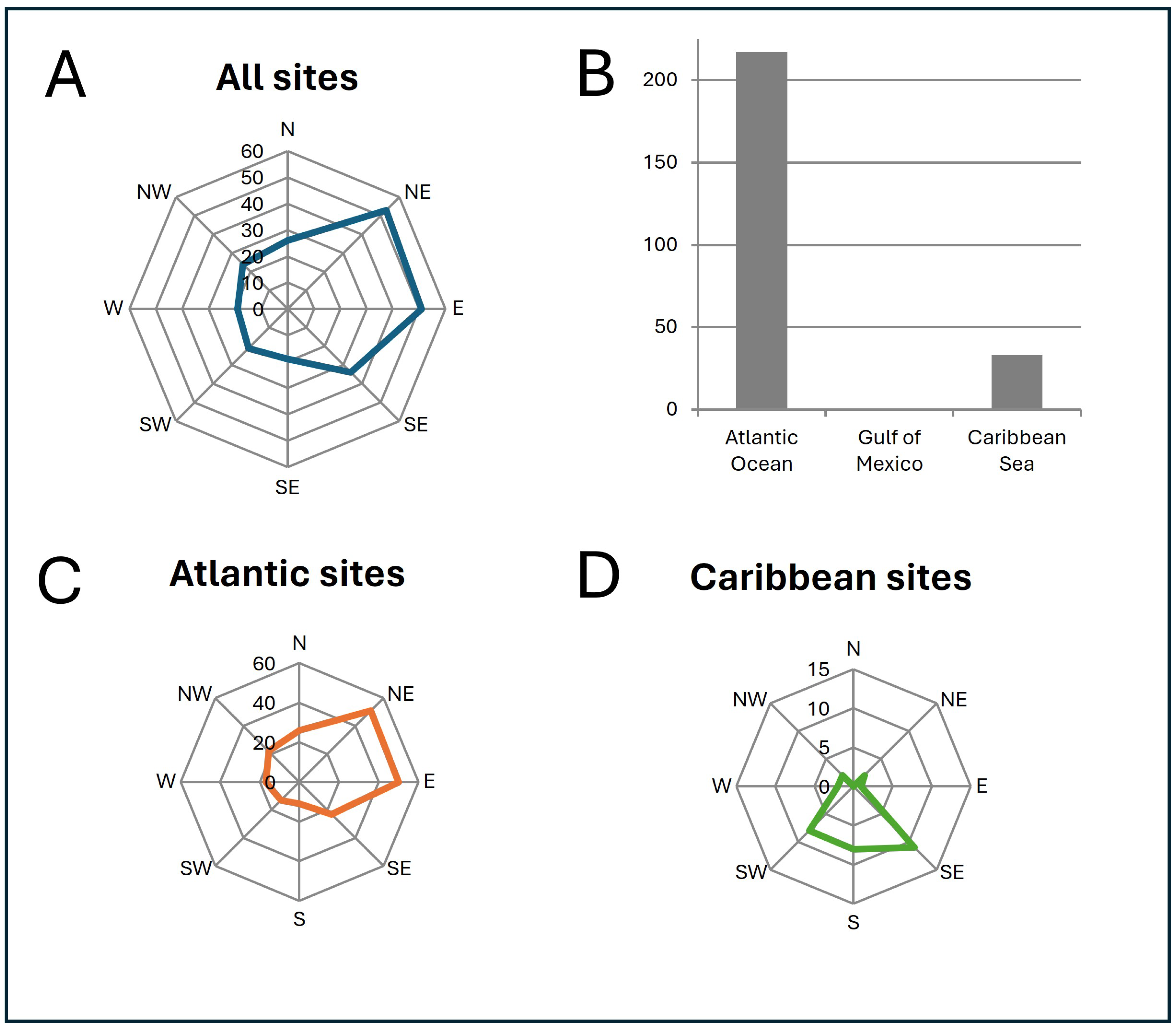
5.2. Statistical Results

Statistical analysis was restricted to those variables that potentially have a direct impact on beach ridge formation or morphology. From the 250 site identifications from Google Earth©, the first level of separation identified modern and inactive beach ridge complexes, as the latter do not reflect modern coastal processes and environmental settings. The modern beach ridge sites were analysed further in relation to the number of beach ridges present, the proximity of a river or reef, the orientation of the beach ridge plain and the storm context for each site. If one or more of these variables was missing, the beach ridge site was excluded from analysis.
In Table 2 and Table 3, “Number” represents the minimum number of beach ridge features recorded at each site; “River” or “Reef” indicates the presence or absence of a river or adjacent reef, respectively; “Orientation” represents the orientation of a site in geographical degrees; and “Storm density” represents the density of storm events for the period from 1851 to 2012 for a 30 × 30 km grid square and is an approximation of the extreme wave environment. After the exclusion of inactive sites (22), for eight active sites, one or more variables were not recorded, leaving a sample of 220 sites for the first PCA (Table 2).
The correlation matrix in Table 2 shows the strongest link between the presence of a reef and the storm density at a site, and then the number of beach ridges per site. Note that the correlation value is low, as the maximum is only 0.28531 on a maximum scale that reaches 1. The strongest dissociation is between the rivers and reefs, with a value of −0.179246 (which is also a low value). The river variable has only one positive correlation (with the number of ridges), making it the variable with the strongest dissimilarity of the group of five.
From these first results, a second PCA (Table 3) was performed, excluding the river-associated sites. This new sample contains 204 beach ridge sites.
Four cluster analyses performed on the original dataset are summarised in Table 4. First, cluster analysis was performed on the modern beach ridge dataset. The second analysis focused only on those sites with a coral reef. The coral reef distance replaced the coral reef presence variable in Sets 2 and 4. The number of sites included in each cluster analysis varies (it ranges from 134 to 220).
Six classes were created, as this level of separation was important enough to observe the trends that can have meaning at the regional level. The number of beach ridge sites per class is variable and ranges from one to one hundred and twenty-four in the twenty-four classes created within the four different cluster analysis. Nonetheless, three different clusters each contain a large number of beach ridge sites: Set 1, Group 3, with N = 124; Set 2, Group 3, with N = 80; and Set 4, Group 6, with N = 80. No discriminating factor was identified for these three cases at this level of separation.
For all the four sets, we observe two major similarities; first, there is a class with a low storm density in each cluster, and second, there are six groups with a high number of beach ridges. The presence of a reef and the orientation of the beach ridge plain variables seem to play a major role only for Set 3, separating three groups. However, in other cluster analysis, they play a minor role in the classification, as the two classes do not differentiate any of the other groups.
Looking at the results on five variables only (Sets 1 and 2), we observe the emergence of a class associated with the presence of a river. This remains even when changing the variables and the number of beach ridges from Set 1 to Set 2. From these results and the PCA results in the section above (Table 2), we progressed empirically in our cluster analysis by excluding the river-associated sites and the river variable from the analysis in Sets 3 and 4. Note in Set 2, where the distance to the reef replaces the presence of a reef, this change separates only one class (Group 5 with N = 9).
In the results on four variables (Sets 3 and 4), after the major separation of classes due to the number of beach ridges and storm density, the orientation for Set 3 and the distance to the reef for Set 4 discriminate the classes.
Interestingly, a class with only one beach ridge site appears in the sets with the variable reef presence, in Set 1 (Group 5) and in Set 3 (Group 2). After verification, the same beach ridge, Bahamas_BR2 (Figure 3A), contains the highest number of beach ridges (50). When in Sets 2 and 4 the reef distance replaces the reef presence, this same beach ridge site is then reclassified in the group with the highest number of beach ridges.

6. Discussion

There are clear spatial patterns in the distribution of beach ridge plains and their environmental setting. This is accompanied by a diversity of geomorphic forms among the beach ridges on the islands of the Greater Caribbean. A large spatial scale investigation such as this allows for hypotheses to be constructed regarding the possible relationship between the beachridge form and geological setting/forcing conditions that can then be tested via high-resolution investigations of the individual sites. It also identifies the regional trends in beachridge occurrence and prompts questions regarding why they are developed in some areas and not others, despite the apparent similarities in environmental setting.

6.1. Geomorphic Variability

The spatial distribution of a beach ridge site shows preferential development in the northeast of the study area, specifically on the islands surrounded or fringed by coral reefs. Numerous sites (157 reported here and 20 further sites from the literature review) are in the Bahamas Archipelago (Bahamas or Turks and Caicos Islands). The number of ridges ranges from two in the Abaco islands to a minimum of fifty in Bahamas_BR2 in the Great Inagua Island (already noted by Scheffers et al. [7]). The north coast of Cuba also contains a large number of sites with a similar variability in size and number of beach ridges as those of the The Bahamas and Turks and Caicos. On smaller islands like Barbuda, Anegada or the sites in the Leeward Antilles, there are numerous beach ridge plains, but of limited extent. Hispaniola and Puerto Rico have relatively few sites around their coastlines, and these are mainly associated with rivers. These sites can be compared to chenier plains like those described on the mainland Gulf of Mexico shorelines [6,49].
Inactive beach ridge plains were noted in The Bahamas and on the island of Barbuda. The inactive beach ridges in Barbuda have been linked to the Pleistocene highstand [34]. They are similar to those observed in the Bahamas islands [39] and contain an aeolian component.
Multiple beach ridges commonly occur in strongly embayed locations (Figure 3G), where they have catenary plan forms, suggesting strong cross-shore transport dominance under fully refracted waves (swash alignment). The other sites with high numbers of ridges occur as spits with definite re-curves (Figure 3D,F,E) that point to a strong longshore element in their genesis.

6.2. Regional Wave Conditions

The origin of beach ridges has been linked to the changing hydrodynamic conditions, such as the occurrence of wind or swell and storm waves [4], aperiodic tsunami waves [14], variations in sediment supply [50] and sea-level change [10]. Five main hypotheses are discussed in the literature for beach ridge genesis: break point bar development [4], storm swash run-up [51], longshore drift bar development [8], the redistribution of storm sediments [45] and a combination of them all [8]. Beach ridges are generally considered to represent long periods of accumulation associated with a large sediment supply (fair-weather conditions) punctuated by erosional events associated with storms that erode ridges [10,42,52]. In this study, the fact that some areas of high beach ridge abundance coincide with storm density is a good argument for cause and effect. However, some high-storm-density areas do not have beach ridges, and beach ridges do occur in some areas of low storm density. This indicates that other factors (e.g., sediment availability and accommodation space) are also important.
In the greater Caribbean, the sea level risen throughout the Holocene [20,29]. Toscano and Macintyre [29] describe a high rate of 5.2 mm year−1 sea-level rise from 10,600 years BP to 7700 years BP. The rate of sea-level rise decreased to 1.47 mm year−1 from 7700 to 2000 years BP and to ca. 0.93 mm year−1 for the last 2000 years. The abrupt decrease in rate of sea-level rise around 7700 years BP coincides with the first colonisation of Caribbean islands by humans [20]. Since then, the coastal landscapes have stabilised and matured under a relatively stable sea level [18,53]. Thus, a falling sea level can be eliminated as a causative factor for beach ridge genesis in the Greater Caribbean.
There are numerous studies on storm and hurricane records for the North Atlantic basin [54,55]. In this study, we used storm density as a proxy for extreme wave regimes. This variable appears to be strongly linked to beach ridge presence and the number of ridges in some locations, but not all. The concentration of beach ridge plains in The Bahamas is quite marked and coincides with a high storm density. Park [56] (p. 802) noted that “The Bahamas are struck by more hurricanes than any other area in the Caribbean Basin”. Little research has been conducted on storm deposits in The Bahamas, but the presence of erosional surfaces in the GPR profiles reported by Buynevich et al. [42,57,58] have been interpreted as evidence that storm activity causes periodic shoreline erosion on beach ridge plains.
Although numerous islands in the Lesser Antilles group are exposed to a moderate-to-high storm density, only two islands actually contain beach ridges: Anegada and Barbuda. These two carbonate platforms are unique among the lesser Antilles and point to the reef as the sediment source and the reef crest as the sediment sink that provides both sediment supply and accommodation space, respectively, for beach ridge plain development. In contrast, the group of islands off Venezuela have a low storm density, but abundant beach ridge development.
The role of storms and swells in beach ridge genesis is still poorly understood [8]. Along the northwest Australian coast, a link has been suggested between the accretion of beach ridge landforms and the passage of level 1 or 2 typhoons [59]. Whereas our results suggest a generalised link between beach ridge abundance and high storm density, the occurrence of beach ridges in low-density areas and their absence in some high-density areas points to other factors, such as local sediment abundance and accommodation space, as the key variables in their development.
The large number of Atlantic-facing sites show the strong influence of Atlantic waves in beach ridge genesis. Both cross-shore and longshore sediment transport is enhanced by storm waves [60], but has particular importance here for the delivery of sediment from the reef crest and reef flat to the coast [61]. The dominance of Atlantic-facing systems also points to the potential role of swells, including large swell events in generating beach ridges [24]. In contrast, systems on the Caribbean-facing coast are sheltered from swell effects and might be expected to be more closely related to the occurrence of hurricanes. Hurricane-generated breach structures like those described by Suter et al. [62] on the Texas coast are present in some of the Cuban Caribbean sites (Cuba_BR152 in Figure 3F).
No sandy beach ridge has yet been conclusively assigned to tsunami genesis [8]. Tsunami waves have, however, breached the Atlantic-facing sandy beach ridges on Anegada [28] and other sites within the Caribbean Sea [63]. Liew et al. [64] studied the behaviour of several coastal sites after the 2004 Sumatra tsunami in Indonesia, one of which was a sandy beach ridge plain overtopped by the tsunami that caused an increase in the size of the existing inlets. There rapid post-tsunami recovery of the shoreline led to the restoration of the beach profile within two years. The 2011 Tohoku-oki tsunami flowed over a beach ridge plain in the Sendai plain in Japan, where the most seaward ridge served as a natural barrier to the flow [65]. After tsunami inundation, some erosional unconformities were formed, but in other locations, a decimetre-thick unit was deposited on top of the existing beach ridges without modifying the beach ridge structure [65]. These two modern examples can be used to understand the breaching of sandy beach ridges on Anegada Island [28]. It seems that tsunamis are more likely to erode the existing ridges than deposit new ones and can probably be ruled out as an important sandy beach ridge construction mechanism in the study area. Other authors have discussed their effect on coarse sediment ridges mainly on the Leeward Antilles [66,67].
Coarse clast beach ridges seem not to be visible on the Google Earth© mapping for this regional study, even though several have been described in the literature. In the Greater Caribbean, coral clast ridges weather [37] and become vegetated [26,66]. This may contribute to the difficulty in identifying them using Google Earth© imagery.

6.3. Beach Ridge Construction

Most islands in the Greater Caribbean are surrounded by a coral reef [66], and for many islands, reefs are the only source of sediment production; among the 147 sites with associated a coral reef on the 250 sites mapped from Google Earth©, only 5 have an additional input of terrestrial material represented by a river. The presence of a reef thus appears to be an essential element in construction of many beach ridges. Coral reefs have been degrading since the 1970s around the Caribbean Sea, and many are considered strongly endangered [66,67]. The implications of such degradation on the adjacent beach ridge sites are not known, but can be speculated upon. In one scenario, reef breakdown could lead to a temporary increase in sedimentary material, followed by longer-term decline as the reef material is exhausted and is not replaced. The breakdown of reefs could also lead to beach ridge plains having a higher level of vulnerability to wave events.
Differentiation between sandy beach ridges and foredunes can be difficult, even in the field [3]. This differentiation may not be crucial, however, since Mauz et al. [68] propose a new conceptualisation that sees the beach ridge as a composite (or complex) landform with a landward foredune component and seaward shallow marine facies. This may help reconcile terminology, for example, in The Bahamas, where dunes and eolianites are widely distributed [40], but beach ridges have only recently been reported [7,42].

6.4. A Regional Classification of Beach Ridge Plains

Beach ridges have previously been categorised according to geomorphology and environmental settings into those formed in non-deltaic strandplains, deltaic strandplains, spits and barrier islands [15]. Based on a regional approach, a tentative morphological classification of beach ridges in the Greater Caribbean islands is presented here (Figure 7). Whether they are purely related to wave-induced processes or are a complex deposit of wave and aeolian processes cannot be determined by this study and needs further investigation. Swash-aligned systems are certainly dominated by wave processes (because of the limited shore-normal fetch distance for aeolian transport), whereas longshore-drift-aligned systems have a higher potential for the accumulation of wind-lain deposits. These factors require further investigation, and a provisional assessment of drift vs. swash alignment could readily be made to upgrade this dataset. Similarly, the poor correlation of variables observed in our analysis may be improved by the collection of additional datasets on, for example, beachridge system length and width, as in Isla et al. [15].
The primary division according to the analysis performed here is active and inactive systems. The inactive beach ridges are typically well vegetated, present discordances from the actual shoreline processes and show signs of erosion. These inactive systems relate to the former high sea levels of the Pleistocene. They may or may not have formed under forced regression from Pleistocene highstands, particularly those of MIS 5 [69]. Active beach ridges on the islands of the Greater Caribbean are distant from continental influences and mostly owe their existence to a supply of carbonate sediment from the adjacent coral reefs. A few systems on the larger islands are associated with supply of terrigenous sediment of fluvial origin.
The formative mechanism of beach ridges in reef settings is poorly understood. Although they are widely attributed to accumulation during fair-weather events, with a positive sediment budget, and erosion during storms to form a beach ridge, sediment must be delivered to the nearshore, and then emplaced above the normal high-tide level (implying high-energy events). Whether this occurs in one process or event is unclear; however, the formation of discrete ridges points to episodic sediment delivery. In cases where multiple beach ridges develop, the episodic delivery process must be repeated multiple times. The large number of beach ridge sites with more than 10 ridges in the Greater Caribbean highlights the need for more sedimentological studies, as advocated by Tamura [8]. Only by a fuller understanding of their formative processes can their full utility as palaeostorm archives be realised.

7. Conclusions

This work extends upon the work of Scheffers et al. [7] by increasing the number of documented beach ridge sites around the Greater Caribbean islands to 250. This methodology successfully extends the bibliographical record of beach ridge sites, but is unable to identify several beach ridge sites described in the literature. This may be due to issues of resolution, and in particular, to the definition of beach ridges in densely vegetated or urbanised locations. This remote approach, however, allows for multiple beach ridge sites to be described and compared over a large area and can help identify sites for targeted fieldwork to better understand sedimentological and wave processes.
At the regional level, a classification is proposed based on the observations and statistical analysis. The first level of separation differentiates active and inactive beach ridges, supporting the idea of a recurrence of the landform during regent geological times (Pleistocene and Holocene) for the Greater Caribbean islands. The second level of separation is related to the sediment source for beach ridge construction. Either the beach ridge plain is related to a river or to the presence of a coral reef and dependant on the carbonate production and the reef ecological situation. Finally, coastal processes affect beach ridge construction by their regionalisation; the sites facing the Atlantic Ocean have a different wave setting than the ones facing the Caribbean Sea.

Author Contributions

Conceptualization, A.L.C. and J.A.G.C.; methodology, A.L.C.; formal analysis, A.L.C. and J.A.G.C.; writing—original draft preparation, A.L.C. and J.A.G.C.; writing—review and editing, A.L.C., J.A.G.C. and D.W.T.J.; supervision, J.A.G.C. and D.W.T.J.; funding acquisition J.A.G.C. All authors have read and agreed to the published version of the manuscript.

Funding

This research formed part of a University of Ulster VCRS-funded PhD study by Anna Lisa Cescon.

Institutional Review Board Statement

Not applicable.

Informed Consent Statement

Not applicable.

Data Availability Statement

A .kmz file of the beachridge locations is available on request from the corresponding author.

Conflicts of Interest

The authors declare no conflict of interest.

References

  1. Hesp, P.A. The formation of sand ‘beach ridges’ and foredunes. Search 1984, 15, 9–10. [Google Scholar]
  2. Hesp, P. Sand Beach Ridges: Definitions and Re-Definition. J. Coast. Res. 2004, 39, 72–75. [Google Scholar]
  3. Hesp, P.A.; Dillenburg, S.R.; Barboza, E.G.; Tomazelli, L.J.; Ayup-Zouain, R.N.; Esteves, L.S.; Gruber, N.L.S.; Toldo, E.E., Jr.; Tabajara, L.L.C.D.A.; Clerot, L.C.P. Beach ridges, foredunes or transgressive dunefields? Definitions and an examination of the Torres to Tramandaí barrier system, Southern Brazil. Ann. Acad. Bras. Ciênc. 2005, 77, 493–508. [Google Scholar] [CrossRef]
  4. Nott, J. A theory (involving tropical cyclones) on the formation of coarse-grained sand beach ridges in NE Australia. Geol. Soc. Lond. Spec. Publ. 2010, 346, 7–22. [Google Scholar] [CrossRef]
  5. Nott, J.; Chague-Goff, C.; Goff, J.; Sloss, C.; Riggs, N. Anatomy of sand beach ridges: Evidence from severe Tropical Cyclone Yasi and its predecessors, northeast Queensland, Australia. J. Geophys. Res. Earth Surf. 2013, 118, 1710–1719. [Google Scholar] [CrossRef]
  6. Otvos, E.G. Beach ridges—Definitions and significance. Geomorphology 2000, 32, 83–108. [Google Scholar] [CrossRef]
  7. Scheffers, A.; Engel, M.; Scheffers, S.; Squire, P.; Kelletat, D. Beach ridge systems—Archives for Holocene coastal events? Prog. Phys. Geogr. 2012, 36, 5–37. [Google Scholar] [CrossRef]
  8. Tamura, T. Beach ridges and prograded beach deposits as palaeoenvironment records. Earth-Sci. Rev. 2012, 114, 279–297. [Google Scholar] [CrossRef]
  9. Tanner, W.F. Origin of beach ridges and swales. Mar. Geol. 1995, 129, 149–161. [Google Scholar] [CrossRef]
  10. Taylor, M.; Stone, G.W. Beach-Ridges: A Review. J. Coast. Res. 1996, 12, 612–621. [Google Scholar]
  11. Catuneanu, O. Sequence Stratigraphy of clastic systems: Concepts, merits, and pitfalls. J. Afr. Earth Sci. 2002, 35, 1–43. [Google Scholar] [CrossRef]
  12. Goy, J.L.; Zazo, C.; Dabrio, C.J. A beach-ridge progradation complex reflecting periodical sea-level and climate variability during the Holocene (Gulf of Almeria, Western Mediterranean). Geomorphology 2003, 50, 251–268. [Google Scholar] [CrossRef]
  13. Spiske, M.; Halley, R.B. A coral-rubble ridge as evidence for hurricane overwash, Anegada (British Virgin Islands). Adv. Geosci. 2014, 38, 9–20. [Google Scholar] [CrossRef]
  14. Scheffers, A.M.; Scheffers, S.R.; Kelletat, D.H.; Squire, P.; Collins, L.; Feng, Y.; Zhao, J.; Joannes-Boyau, R.; May, S.M.; Schellmann, G.; et al. Coarse clast ridge sequences as suitable archives for past storm events? Case study on the Houtman Abrolhos, Western Australia. J. Quat. Sci. 2012, 27, 713–724. [Google Scholar] [CrossRef]
  15. Isla, M.F.; Moyano-Paz, D.; FitzGerald, D.M.; Simontacchi, L.; Veiga, G.D. Contrasting beach-ridge systems in different types of coastal settings. Earth Surf. Process. Landf. 2023, 48, 47–71. [Google Scholar] [CrossRef]
  16. Nooren, K.; Hoek, W.Z.; Winkels, T.; Huizinga, A.; Van der Plicht, H.; Van Dam, R.L.; Van Heteren, S.; Van Bergen, M.J.; Prins, M.A.; Reimann, T.; et al. The Usumacinta–Grijalva beach-ridge plain in southern Mexico: A high-resolution archive of river discharge and precipitation. Earth Surf. Dyn. 2017, 5, 529–556. [Google Scholar] [CrossRef]
  17. Keegan, W.F.; Hofman, C.L.; Ramos, R.R. Introduction. In The Oxford Handbook of Caribbean Archeology; Keegan, W.F., Hofman, C.L., Ramos, R.R., Eds.; Oxford University Press: Oxford, UK, 2013; pp. 1–18. [Google Scholar]
  18. Cambers, G. Caribbean Islands, Coastal Ecology and Geomorphology. In Encyclopedia of Coastal Science; Schwartz, M., Ed.; Springer: Dordrecht, The Netherlands, 2005; pp. 216–355. [Google Scholar]
  19. Milne, G.A.; Long, A.J.; Bassett, S.E. Modelling Holocene relative sea-level observations from the Caribbean and South America. Quat. Sci. Rev. 2005, 24, 1183–1202. [Google Scholar] [CrossRef]
  20. Cooper, J. The Climatic Context for Pre-Columbian Archaeology in the Caribbean. In The Oxford Handbook of Caribbean Archeology; Keegan, W.F., Hofman, C.L., Ramos, R.R., Eds.; Oxford University Press: Oxford, UK, 2013; pp. 47–58. [Google Scholar]
  21. Kindler, P.; Strasser, A. Palaeoclimatic significance of co-occurring wind-and water-induced sedimentary structures in the last-interglacial coastal deposits from Bermuda and the Bahamas. Sediment. Geol. 2000, 131, 1–7. [Google Scholar] [CrossRef]
  22. Donnelly, J.P.; Woodruff, J.D. Intense hurricane activity over the past 5,000 years controlled by El Nino and the West African monsoon. Nature 2007, 447, 465–468. [Google Scholar] [CrossRef] [PubMed]
  23. Elsner, J.B. Climatology: Tempests in time. Nature 2007, 447, 647–649. [Google Scholar] [CrossRef] [PubMed]
  24. Cooper, J.A.G.; Jackson, D.W.T.; Gore, S. A groundswell event on the coast of the British Virgin Islands: Spatial variability in morphological impact. J. Coast. Res. 2013, 1, 696–701. [Google Scholar] [CrossRef]
  25. Zahibo, N.; Pelinovsky, E.; Yalciner, A.C.; Kurkin, A.; Koselkov, A.; Zaitsev, A. The 1867 Virgin Island Tsunami. Nat. Hazards Earth Syst. Sci. 2003, 3, 367–376. [Google Scholar] [CrossRef]
  26. Scheffers, A. Coastal response to extreme wave events: Hurricane and tsunami on Bonaire. Essen. Geogr. Arb. 2005, 37, 96. [Google Scholar]
  27. Morton, R.A.; Richmond, B.M.; Jaffe, B.E.; Gelfenbaum, G. Coarse-Clast Ridge Complexes of the Caribbean: A Preliminary Basis for Distinguishing Tsunami and Storm-Wave Origins. J. Sediment. Res. 2008, 78, 624–637. [Google Scholar] [CrossRef]
  28. Atwater, B.; Uri, S.; Buckley, M.; Halley, R.S.; Jaffe, B.E.; López-Venegas, A.M.; Reinhardt, E.G.; Tuttle, M.P.; Watt, S.; Wei, Y. Geomorphic and stratigraphic evidence for an unusual tsunami or storm a few centuries ago at Anegada, British Virgin Islands. Nat. Hazards 2012, 63, 51–84. [Google Scholar] [CrossRef]
  29. Toscano, M.; Macintyre, I. Corrected western Atlantic sea-level curve for the last 11,000 years based on calibrated 14C dates from Acropora palmata framework and intertidal mangrove peat. Coral Reefs 2003, 22, 257–270. [Google Scholar] [CrossRef]
  30. Gore, S.; Cooper, J.A.G.; Jackson, D.W.; Jarecki, L. Spatial variability in beach biogeomorphology in a tropical archipelago. Earth Surf. Process. Landf. 2019, 44, 1860–1875. [Google Scholar] [CrossRef]
  31. Brooks, G.R.; Larson, R.A.; Devine, B.; Schwing, P.T. Annual to millennial record of sediment delivery to US Virgin Island coastal environments. Holocene 2015, 25, 1015–1026. [Google Scholar] [CrossRef]
  32. Buynevich, I.V.; Savarese, M.; Curran, H.A.; Bitinas, A.; Glumac, B.; Pupienis, D.; Kopcznski, K.A.; Dobrotin, N.; Gnivecki, P.L.; Park Boush, L.E.; et al. Sand incursion into temperate (Lithuania) and tropical (the Bahamas) maritime vegetation: Georadar visualization of target-rich aeolian lithosomes. Estuar. Coast. Shelf Sci. 2017, 195, 69–75. [Google Scholar] [CrossRef]
  33. Brasier, M.; Donahue, J. Barbuda—An emerging reef and lagoon complex on the edge of the Lesser Antilles island arc. J. Geol. Soc. 1985, 142, 1101–1117. [Google Scholar] [CrossRef]
  34. Brasier, M.D.; Mather, J.D. The stratigraphy of Barbuda, West Indies. Geol. Mag. 1975, 112, 271–282. [Google Scholar] [CrossRef]
  35. Gore, S.D. Beach Geomorphology and Management of the British Virgin Islands. Unpublished Ph.D Thesis, University of Ulster, Coleraine, UK, 2012. [Google Scholar]
  36. Cescon, A.L.; Cooper, J.A.G.; Jackson, D.W.; Collin, A.; Gore, S. Mesoscale Shoreline Evolution on a Carbonate Sand Island: Anegada, British Virgin Islands. J. Mar. Sci. Eng. 2023, 11, 1725. [Google Scholar] [CrossRef]
  37. Folk, R.; Robles, R. Carbonate sands of Isla Perez, Alacran Reel complex, Yucatan. J. Geol. 1964, 72, 255–292. [Google Scholar] [CrossRef]
  38. Scheffers, S.R.; Haviser, J.; Browne, T.; Scheffers, A. Tsunamis, hurricanes, the demise of coral reefs and shifts in prehistoric human populations in the Caribbean. Quat. Int. 2009, 195, 69–87. [Google Scholar] [CrossRef]
  39. Ball, M.M. Carbonate Sand Bodies of Florida and The Bahamas. J. Sediment. Petrol. 1967, 37, 556–591. [Google Scholar]
  40. Brooke, B. The distribution of carbonate eolianite. Earth-Sci. Rev. 2001, 55, 135–164. [Google Scholar] [CrossRef]
  41. Enos, P. Bahamas. In Encyclopedia of Modern Coral Reefs; Hopley, D., Ed.; Springer: Dordrecht, The Netherlands, 2011; pp. 85–93. [Google Scholar]
  42. Buynevich, I.V.; Savarese, M.; Park Boush, L.E.; Curran, H.A.; Glumac, B.; Sayers, J.; Brady, K.; Myrbo, A.E.; Ingalsbe, T.A.; Rychlak, H. Event-scale morphological and geophysical (GPR) signatures in Bahamian coastal lithosomes. In Proceedings of the Geological Society of America Annual Meeting Abstracts with Programs, Denver, CO, USA, 27–30 October 2013; p. 563. [Google Scholar]
  43. Allen, T.R.; Oertel, G.F.; Gares, P.A. Mapping coastal morphodynamics with geospatial techniques, Cape Henry, Virginia, USA. Geomorphology 2012, 137, 138–149. [Google Scholar] [CrossRef]
  44. National Climatic Data Center. International Best Track Archive for Climate Stewardship; National Climatic Data Center: Asheville, NC, USA, 2015. Available online: https://www.ncei.noaa.gov/products/international-best-track-archive (accessed on 1 June 2016).
  45. Otvos, E.G. Hurricane signatures and landforms-toward improved interpretations and global storm climate chronology. Sediment. Geol. 2011, 239, 10–22. [Google Scholar] [CrossRef]
  46. National Geophysical Data Center/World Data Service. Global Historical Tsunami Database. 2015. Available online: http://www.ngdc.noaa.gov/hazard/tsu_db.shtml (accessed on 1 June 2016).
  47. R Core Team. R: A Language and Environment for Statistical Computing; R Foundation for Statistical Computing: Vienna, Austria, 2014. [Google Scholar]
  48. Hillier, J.K.; Smith, M.J.; Armugam, R.; Barr, I.; Boston, C.M.; Clark, C.D.; Ely, J.; Frankl, A.; Greenwood, S.L.; Gosselin, L.; et al. Manual mapping of drumlins in synthetic landscapes to assess operator effectiveness. J. Maps 2014, 11, 719–729. [Google Scholar] [CrossRef]
  49. Psuty, N.P. Beach-ridge development in Tabasco, Mexico 1. Ann. Assoc. Am. Geogr. 1965, 55, 112–124. [Google Scholar] [CrossRef]
  50. Isla, F.I.; Bujalesky, G.G. Cannibalisation of Holocene gravel beach-ridge plains, northern Tierra del Fuego, Argentina. Mar. Geol. 2000, 170, 105–122. [Google Scholar] [CrossRef]
  51. Rogers, S.S.; Sandweiss, D.H.; Maasch, K.A.; Belknap, D.F.; Agouris, P. Coastal change and beach ridges along the northwest coast of Peru: Image and GIS analysis of the Chira, Piura, and Colan beach-ridge plains. J. Coast. Res. 2004, 20, 1102–1125. [Google Scholar] [CrossRef]
  52. Brooke, B.P.; Huang, Z.; Nicholas, W.A.; Oliver, T.S.; Tamura, T.; Woodroffe, C.D.; Nichol, S.L. Relative sea-level records preserved in Holocene beach-ridge strandplains—An example from tropical northeastern Australia. Mar. Geol. 2019, 411, 107–118. [Google Scholar] [CrossRef]
  53. Kennedy, D.; Woodroffe, C. Fringing reef growth and morphology: A review. Earth-Sci. Rev. 2002, 57, 255–277. [Google Scholar] [CrossRef]
  54. Landsea, C.W. Counting Atlantic tropical cyclones back to 1900. Eos 2007, 88, 197–208. [Google Scholar] [CrossRef]
  55. Mann, M.E.; Woodruff, J.D.; Donnelly, J.P.; Zhang, Z. Atlantic hurricanes and climate over the past 1,500 years. Nature 2009, 460, 880–883. [Google Scholar] [CrossRef] [PubMed]
  56. Park, L.E. Comparing Two Long-Term Hurricane Frequency and Intensity Records from San Salvador Island, Bahamas. J. Coast. Res. 2012, 28, 891–902. [Google Scholar]
  57. Buynevich, I.V.; Savarese, M.; Kadurin, S.V.; Larchenkov, E.P.; Park Boush, L.E.; Curran, A.H.; Beal, I.A. Morphodynamics and geological legacy of berm scarps along non-tidal (Ukraine) and microtidal (the Bahamas) coasts. In Geology and Geography Bulletin; Odesa National University: Odessa, Ukraine, 2014; Volume 19, pp. 177–187. [Google Scholar]
  58. Buynevich, I.V.; Kopcznski, K.A.; Savarese, M.; Park Boush, L.E.; Curran, H.A.; Glumac, B.; Caris, J. Subsurface signatures of recent storm erosion and recovery along San Salvador Island, The Bahamas. In Proceedings of the GSA Annual Meeting in Denver, Denver, CO, USA, 25–28 September 2016. [Google Scholar] [CrossRef]
  59. Nott, J.; Hayne, M. High frequency of ‘super-cyclones’ along the Great Barrier Reef over the past 5,000 years. Nature 2001, 413, 508–512. [Google Scholar] [CrossRef] [PubMed]
  60. De Alegria-Arzaburu, A.R.; Mariño-Tapia, I.; Enriquez, C.; Silva, R.; González-Leija, M. The role of fringing coral reefs on beach morphodynamics. Geomorphology 2013, 198, 69–83. [Google Scholar] [CrossRef]
  61. Brander, R.W.; Kench, P.S.; Hart, D. Spatial and temporal variations in wave characteristics across a reef platform, Warraber Island, Torres Strait, Australia. Marine Geology 2004, 207, 169–184. [Google Scholar] [CrossRef]
  62. Suter, J.R.; Nummedal, D.; Maynard, A.K.; Kemp, P. A Process-Response Model for Hurricane Washovers. In Coastal Engineering 1982 Proceedings; ASCE Press: Reston, VA, USA, 1982; pp. 1459–1478. [Google Scholar]
  63. Harbitz, C.B.; Glimsdal, S.; Bazin, S.; Zamora, N.; Løvholt, F.; Bungum, H.; Kjekstad, O. Tsunami hazard in the Caribbean: Regional exposure derived from credible worst case scenarios. Cont. Shelf Res. 2012, 38, 1–23. [Google Scholar] [CrossRef]
  64. Liew, S.C.; Gupta, A.; Wong, P.P.; Kwoh, L.K. Recovery from a large tsunami mapped over time: The Aceh coast, Sumatra. Geomorphology 2010, 114, 520–529. [Google Scholar] [CrossRef]
  65. Takashimizu, Y.; Urabe, A.; Suzuki, K.; Sato, Y. Deposition by the 2011 Tohoku-oki tsunami on coastal lowland controlled by beach ridges near Sendai, Japan. Sediment. Geol. 2012, 282, 124–141. [Google Scholar] [CrossRef]
  66. Gardner, T.A.; Côté, I.M.; Gill, J.A.; Grant, A.; Watkinson, A.R. Hurricanes and Caribbean coral reefs: Impacts, recovery patterns, and role in long-term decline. Ecology 2005, 86, 174–184. [Google Scholar] [CrossRef]
  67. Aronson, R.B.; Precht, W.F. Conservation, precaution, and Caribbean reefs. Coral Reefs 2006, 25, 441–450. [Google Scholar] [CrossRef]
  68. Mauz, B.; Hijma, M.P.; Amorosi, A.; Porat, N.; Galili, E.; Bloemendal, J. Aeolian beach ridges and their significance for climate and sea level: Concept and insight from the Levant coast (East Mediterranean). Earth-Sci. Rev. 2013, 121, 31–54. [Google Scholar] [CrossRef]
  69. Hearty, P.J.; Kindler, P.; Cheng, H.; Edwards, R.L. A+ 20 m middle Pleistocene sea-level highstand (Bermuda and The Bahamas) due to partial collapse of Antarctic ice. Geology 1999, 27, 375–378. [Google Scholar] [CrossRef]
Figure 1. Beach ridge sites identified in the literature review.
Jmse 12 00565 g001
Figure 2. Beach ridge sites identified in Google Earth©.
Jmse 12 00565 g002
Figure 3. Various typologies of beach ridges around the study area. (A) Beach ridge plain developing behind a coral reef in Inagua island, The Bahamas. (B) Inactive beach ridge plain in Nunjack Cay, The Bahamas, facing the Atlantic. Note the eroded linear features visible underwater in the lower part of the image. (C) Beach ridge plain of limited extent in the Exumas Cays (Little Bells Cay). (D) Extensive beach ridge plain, Cayo Cruz, northeast Cuba. (E) River-associated beach ridge plain in Dominican Republic (North Hispaniola), with river oxbow and westerly longshore transport development. (F) Coral reef-associated beach ridge plain in south-west Cuba, showing evidence (arrowed) of past breaching potentially caused by an extreme wave event. (G) Enclosed, swash-aligned beach ridge plain development in embayments in Major’s Cay, The Bahamas. Note the presence of inlets and a back-barrier water body. (H) Double-facing beach ridge plain in Anegada, British Virgin Islands. North is oriented at top of all the images.
Jmse 12 00565 g003
Figure 4. Distribution of sites according to the number of beach ridges identifiable (0–9 = low; 10–19 = moderate; 20–50 = high).
Jmse 12 00565 g004
Figure 5. (A) Beach ridge orientation, (B) number of beach ridges in each basin, (C) orientation of Atlantic-facing beach ridge sites, and (D) orientation of Caribbean-facing sites.
Jmse 12 00565 g005
Figure 6. Storm density and beach ridge orientation map. The storm density is shown on the 0.25° square grid, and orientation is perpendicular to the beach ridge long axis and given in nautical convention degrees.
Jmse 12 00565 g006
Figure 7. Regional classification of beach ridge sites from Google Earth© imagery.
Jmse 12 00565 g007
Table 1. List of the islands covered by this study arranged by sea and island group, showing spatial extent and maximum altitude (adapted from Keegan et al. [17]).
Sea and GroupIslandsLand Area (km2)Maximum Elevation
(m above MSL)
Caribbean Sea
Greater AntillesCuba110,9221972
Jamaica10,9912256
Cayman Islands24115
Hispaniola (Haiti and Dominican Republican)75,9403175
Puerto Rico88971065
Lesser AntillesVirgin Islands group (UK and US)497523
Anguilla8855
St Martin34742
St Barth25286
Saba13884
St Eustatius21549
St Kitts1761156
Nevis1301156
Barbuda16122
Antigua280403
Montserrat84742
Guadalupe17021467
Dominica7901422
Martinique10901397
St Lucia603951
St Vincent3891179
The Grenadines group86-
Barbados440225
Grenada345840
Trinidad4828941
Tobago300572
Leeward AntillesAruba193167
(continue)Curacao443241
Bonaire288193
Los Roques archipelago40.61-
Other Federal Dependencies of Venezuela (Isla la Tortuga, Isla de Margarita, Isla de Cubagua, Isla de Coche)301.39-
Other IslandsIsla de Cozumel in Mexico647.3314
Banco Chinchorro in Belize6.73
Turneffe Atoll in Belize-approx. SL
Glover Reef in Belize-approx. SL
Bay Islands in Honduras250-
Islands of Cayos Miskitos in Nicaragua27-
Archipelago of San Andres, Providencia and Santa Catalina in Nicaragua52.5-
Gulf of Mexico
Scorpion Reef islands of Mexico0.0001312.3
Atlantic
The Bahamas10,07063
Turks and Caicos islands43048
Table 2. Correlation matrix for 5 variables on the modern beach ridge set (N = 220 sites).
NumberRiverReefOrientationStorm Density
Number10.016770.239161−0.014430.128538
River 1−0.179246−0.046482−0.16794
Reef 1−0.14040.28531
Orientation 10.062853
Storm density 1
Table 3. Correlation matrix for 4 variables on the modern beach ridge set, with exclusion of all river-associated sites (N = 204 sites).
NumberReefOrientationStorm Density
Number10.288355−0.0026030.125821
Reef 1−0.1504890.29064
Orientation 10.056524
Storm density 1
Table 4. Cluster analysis results.
Set 1Set 2Set 3Set 4
Description5 variables, river sites included, N = 2205 variables, river sites included, distance to reef instead of reef presence, N = 1374 variables, no river sites and exclusion of river variable, N = 2044 variables, no river sites, exclusion of river variable, distance to reef instead of reef presence, N = 132
Group 1N = 16; River sitesN = 3; Low storm density (under 10)N = 7; Low storm densityN = 9; Medium to high storm density, high distance to the reef, low number of beach ridges
Group 2N = 49; Moderate number of beach ridges (maximum is 15)N = 10; Large number of beach ridgesN = 1; Large number of beach ridges (50), high storm densityN = 3; Very high storm density (over 39), high distance to the reef
Group 3N = 124; No clear trend at this level of separationN = 80; No clear trend at this level at this level of separationN = 23; High number of beach ridgesN = 27; High storm density (over 30), moderate distance to the reef
Group 4N = 7; Low storm density (under 10)N = 5; River sitesN = 49; Atlantic-facingN = 3; Low storm density (under 10)
Group 5N = 1; Large number of beach ridges (50), high storm densityN = 9; Large distance to the reefN = 58; Orientation under 180, low number of beach ridgesN = 10; Large number of beach ridges
Group 6N = 23; Large number of beach ridges (between 20 and 40), presence of a reefN = 30; High storm density (over 30)N = 66; Caribbean-facing, moderate number of beach ridges N = 80; No clear trend at this level of separation
Disclaimer/Publisher’s Note: The statements, opinions and data contained in all publications are solely those of the individual author(s) and contributor(s) and not of MDPI and/or the editor(s). MDPI and/or the editor(s) disclaim responsibility for any injury to people or property resulting from any ideas, methods, instructions or products referred to in the content.

