1. Introduction
US coastal states are threatened by climate change, sea level rise, tropical and extratropical storms, and inundation [
1,
2,
3]. For several decades, beach nourishment has been a practical and environmentally sustainable engineering method for restoring and protecting shorelines [
4,
5]. It is a versatile approach that can be applied both in emergency situations, such as mitigating storm-induced erosion, and in long-term regional management strategies that aim to counteract erosional tendencies and enhance resilience to climate change [
6,
7]. Beach nourishment serves the multi-purpose of providing storm and flood damage reduction while enhancing recreational, economic, and habitat potential.
One of the major challenges for beach nourishment as a coastal management strategy is the scarcity of beach-compatible sediment resources and the cost involved in dredging offshore borrow sources [
8]. This can limit the feasibility and effectiveness of beach nourishment efforts, particularly in areas with high erosion rates or that have greater than average vulnerability to storm damage. In response, the United States Army Corps of Engineers (USACE) implemented Reginal Sediment Management (RSM) in 1999 with the objective of optimizing sediment use and managing projects through a system-based approach. RSM includes and promotes navigational waterway dredging, flood and storm damage reduction, and environmental practices by enhancing the planning, construction, and maintenance of projects, resulting in the exchange of sediments naturally [
9]. With the threat from coastal erosion and shortage of sediments, RSM adaptation plays a vital role in maintaining coastlines and enhancing the resilience of coastal communities. RSM includes sediment modeling, regional planning, and beneficial use of dredged material (BUDM) [
10]. The objective of this study is to analyze historical RSM/BUDM activities in the United States and use those trends to project future needs while also identifying new potential beaches that could benefit from increasing projects constructed with RSM/BUDM, given their proximity to an inlet.
Federal authorization of dredging is mandated to safely operate approximately 40,000 km of navigation channels and 400 harbors [
11]. Most non-contaminated dredged material can be beneficially reused [
12], such as for beach nourishment, habitat restoration, creation and development, structural and shore protection, recreation, etc. [
13]. RSM/BUDM is one of the sediment management tools in which sediment dredged primarily for navigation and harbor construction is then used to enhance the coastline and provide habitat. States such as Florida, New York, New Jersey, and Louisiana have frequently implemented using dredged sediments from the navigational waterways for beach and dune nourishment [
13,
14,
15,
16]. RSM/BUDM is widely considered a sustainable sediment management practice [
17] that considers both the issue of sediment scarcity and the reduction in costs associated with traditional beach nourishment practices (e.g., versus using offshore sediment sources).
A systematic evaluation of historical trends in RSM/BUDM projects is presented to elucidate potential future sediment requirements. This study examines patterns in existing and historical RSM/BUDM projects to forecast and gain insights into future sediment needs at the regional scale for beneficial placement as beach nourishment. Specifically, the objectives are (1) to evaluate national, long-term RSM/BUDM trends in select coastal states and to compare with non-RSM projects, (2) to forecast sediment volumes required for RSM/BUDM projects for the next 50 years, and (3) to identify new prospective beaches for RSM/BUDM projects that are situated in close proximity to inlets.
2. Materials and Methods
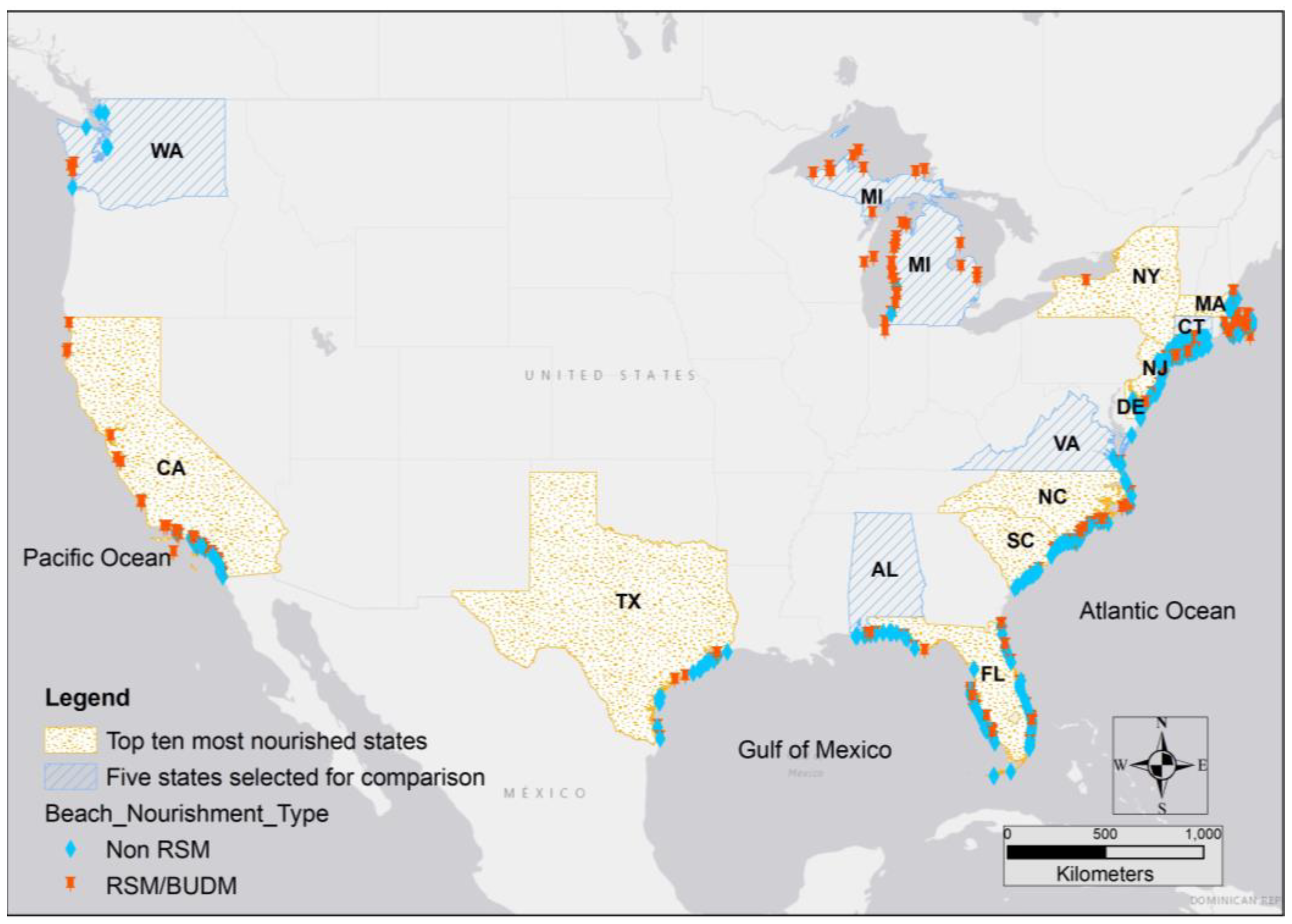
The beach nourishment database maintained by the American Shore & Beach Preservation Association provides information on national beach nourishment activities, including location, length, volume placed, sediment source, and cost. Although this database is updated annually with crowd-sourced and verified information, it is noted that this approach may lead to inaccuracies or gaps in data coverage. These data (updated through 2021) were used to quantify RSM/BUDM and non-RSM activities for the top ten most highly nourished states [
4] in comparison to five selected states without a high volume of nourishment activities (i.e., one from each coast: North Pacific, Gulf of Mexico, Mid-Atlantic, North Atlantic, and Great Lakes) (
Figure 1). The Florida projects are divided into the Atlantic and Gulf coasts in the analysis, as these two coasts have unique morphological features and coastal processes (i.e., the Gulf coast is a marginal sea whereas the Atlantic is an Amero-trailing edge [
18]). For this study, only the number of projects, volume of sediment placed for each project, and year of nourishment event were analyzed.
Based on the trends in existing and historical volume placed, future sediment needs for the next 50 years were forecasted. The Auto-Regressive Integrated Moving Average (ARIMA) model was utilized to obtain future projections. The ARIMA (p, d, q) model is a type of time-series modeling (Nau, 2021) that can be used to predict future values based on past observations. In ARIMA, ‘p’ is the number of autoregressive (AR) terms, which are lagged values of the dependent variable (volume in this case) used to predict future values. The ‘d’ parameter is the number of differences needed to make the time series stationary, i.e., to remove the trend and seasonality. If d = 0, it means the original series is stationary. The ‘q’ parameter is the number of moving average (MA) terms, which are lagged errors of the prediction equation used to forecast future values.
Using the statistical software R version 4.2.3, the ARIMA model was fitted using the ‘arima()’ function [
19]. The function takes time-series objects as input specified by the ‘ts()’ function. For the order of (p, d, q), multiple values were tested, and (1, 0, 1) were considered as the most fitted parameters. The best-fit model was considered based on an accuracy test, which provides Root Mean Square Error (RMSE) and a Ljung-Box test. The Arima() function then estimates the parameters of the model using maximum likelihood. ARIMA (1, 0, 1) model uses the following equation:
where
Yt is the value of the time series at time
t,
µ is the mean of the time series,
α is the autoregressive coefficient,
is the error term at time
t, and
θ is the moving average coefficient.
The ARIMA (1, 0, 1) model was then used to make predictions about future volumes needed for the time series by specifying the number of periods (i.e., 50 years) to be forecasted using the ‘forecast()’ function. This function returns a forecast object that contains the predicted values, along with the confidence intervals. The accuracy of the model was then assessed using the ‘accuracy()’ function that provides Root Mean Square Error (RMSE). The RMSE of the model measures the average magnitude of the errors between predicted and observed values in a time-series dataset. Lower RMSE values indicate better model performance, as they indicate smaller discrepancies between predicted and observed values. The ‘Box.test()’ function was used to perform the Ljung-Box test [
20] for autocorrelation of residuals in the model. This test is an important tool in evaluating the ‘goodness of fit.’ The results of the test provided a
p-value to determine if the model is a good fit. A significant
p-value (<0.05) suggests that there is still autocorrelation left in the residual, and the model needs further refinement. On the other hand, a non-significant
p-value (>0.05) suggests that there is no significant evidence of residual correlation, suggesting the model fits these data well. Modeling was performed, and accuracy tests were obtained for each state individually.
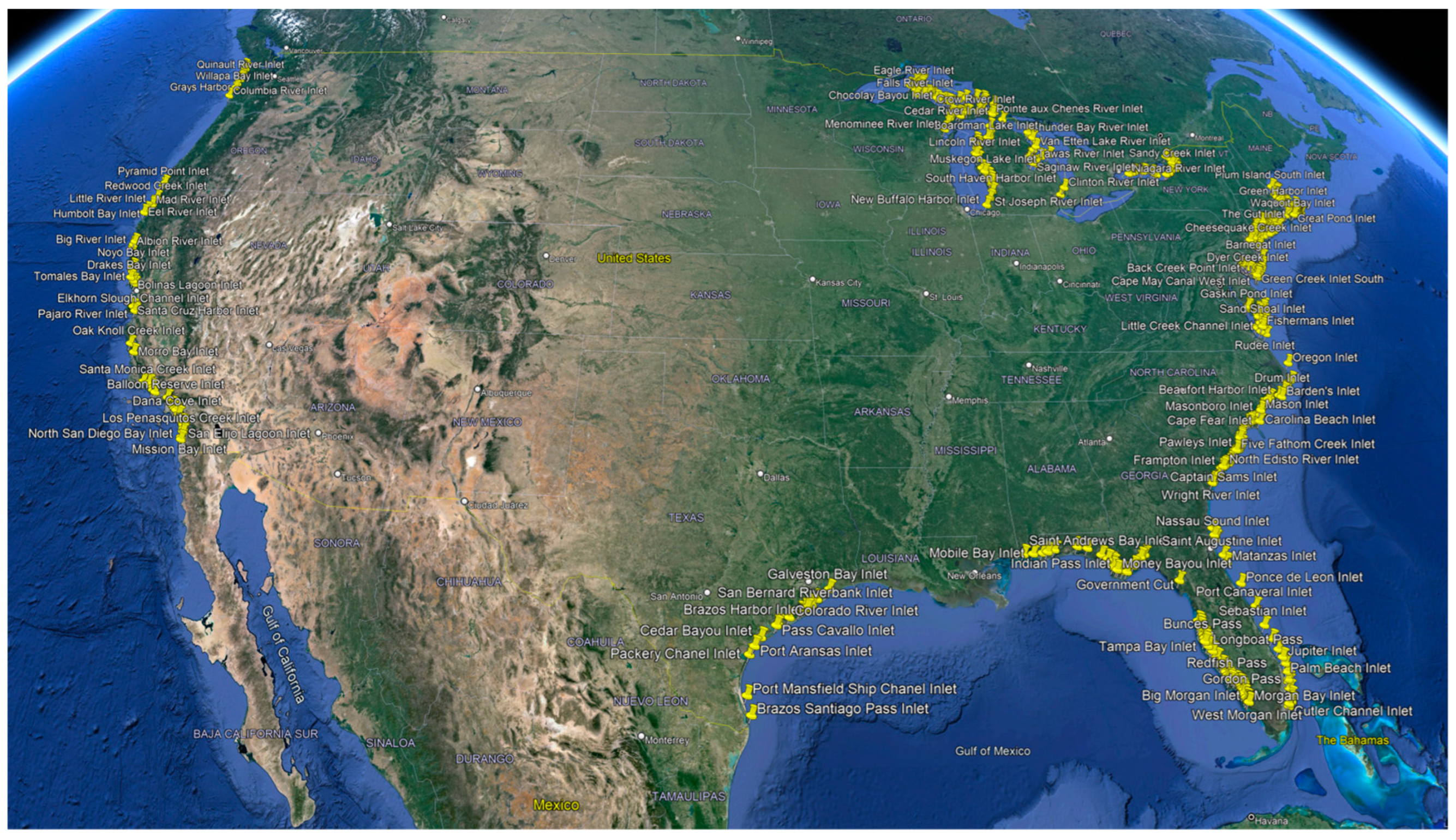
Proximity to inlets and sediment trapping efficiency plays a vital role in leveraging RSM/BUDM principles [
21]. To evaluate the geographical distribution of inlet availability and RSM/BUDM projects, both were mapped in GIS. Structured, half-structured, and unstructured inlets were delineated by analyzing aerial imagery from Google Earth. Each inlet was plotted as a point datum by zooming into the imagery along the coast. These points were then exported to GIS. A buffer tool was applied to the inlet (only structured and half-structured) data set to obtain a 10 km radius polygon. Structured/half-structured inlets were chosen based on their likelihood of regular maintenance and potential as sediment sources. These types of inlets may indicate a higher probability of nourishment activities on the adjacent beaches, given the likelihood of trapping longshore transported sediment. Additionally, the relatively stable channel morphology compared with unstructured inlets (i.e., ease of migration) makes them reliable sources of sediment. The intersect tool was then utilized to obtain the non-RSM projects within the 10 km buffer to the inlets to explore beaches within the scope for RSM/BUDM projects in the future.
3. Results
The distribution of both RSM/BUDM and non-RSM projects was obtained through GIS analysis for the top ten nourished states, as well as five additional states (
Figure 2). In the top ten most nourished states, 1252 projects were classified as RSM/BUDM out of a total of 2804 beach nourishment (BN) projects, accounting for 45% of nourishment activity. California had the highest number of RSM/BUDM projects, with a total of 542 BN projects placing 278,987,069 m
3 of sediment, of which 432 were classified as RSM/BUDM projects with 198,749,497 m
3 of sediment (
Table 1). Massachusetts and North Carolina had the next highest RSM/BUDM activity. In the five non-highly nourished states, 319 of 453 beach BN projects were classified as RSM/BUDM, accounting for 70% of nourishment activities. In Michigan, 306 of the 309 total BN projects were classified as RSM/BUDM, with 6,704,265 m
3 of dredged sediment placed (
Table 2).
Comparing the costs of RSM/BUDM and non-RSM projects reveals significant insights into the efficiency and cost-effectiveness of these two approaches (
Table 3). In the case of non-RSM projects, a total of 1532 projects were analyzed, with an average cost of
$8 per cubic meter and an average cost-per-project of
$3,521,361. The average cost per cubic meter was notably lower at
$5, signifying the cost-efficiency achieved through the RSM/BUDM approach. The cost per project, averaging
$1,439,013, further reinforces the economic advantages of Regional Sediment Management. Delaware (DE) projects a significant cost change through RSM/BUDM, with a notable reduction in the cost-per-project from
$1,941,832 to
$698,750, indicating an increasingly efficient approach in the state. Florida Atlantic coast exhibits a considerable cost reduction per project after adopting RSM/BUDM, dropping from
$3,655,093 to
$2,402,913. These findings feature the benefits of RSM/BUDM projects in achieving cost-efficient beach nourishment. By optimizing sediment use and adopting a system-based approach, RSM/BUDM significantly reduces the financial burden per project, which is particularly crucial in the context of ongoing coastal management and the increasing demand for coastal resilience.
Decadal trends in the number of RSM/BUDM projects were compared with the volume of sediments placed in the top ten states (
Figure 3) and selected five states (
Figure 4). The number of RSM/BUDM projects in the top ten states experienced a notable increase until around the 2000s, after which the frequency of projects reached a stable level in the last decade. However, the total volume of sediment used for RSM/BUDM projects across ten states has declined in the past decade (
Figure 3). The number of RSM/BUDM projects in five states experienced fewer nourishments and were stable except for Michigan. Michigan has had an exponential increase in nourishment activities since 1900 but has had a declining trend in the last decade (
Figure 4). These trends were used for each year in the ARIMA (1, 0, 1) model to obtain future predictions for the volume of sediment required for the next 50 years (
Table 4). A different ARIMA model (1, 1, 0) was selected for Delaware instead of the ARIMA (1, 0, 1) model used for the other states because the former demonstrated a better fit for these data. The model for all the states had
p-values greater than 0.05, which suggested that there was no significant evidence of residual correlation and that the model was a good fit for these data. Because of the high rates of RSM/BUDM historically in California, the models predict a higher volume of sediment will be needed (2,301,613 m
3) for the next 50 years. The states with the next highest forecasted RSM/BUDM needs were North Carolina, New York, and the Florida Atlantic coast, with 766,327 m
3, 433,420 m
3, and 431,680 m
3, respectively. The lowest volume needed was predicted for New Jersey (
Table 5). States with less than ten nourishment activities were not included.
The sum of the volume of sediment placed in the past 50 years for each state was compared with the predicted total volume for the next 50 years (
Table 5). The Root Mean Square Errors (RMSEs) of the predicted models were computed. This margin of error may be within acceptable limits, considering the scale of sediments placed for the purpose of restoration projects. The model suggested that most of the states (FL. Atlantic, NC, DE, NJ, NY, and MI) will experience a decline in the total volume needed for the next 50 years (
Figure 5). On the other hand, CA, FL. Gulf, TX, SC, and MA were expected to see an increase in volume needed for the next 50 years. Based on the predicted total volume, most states are going to reduce the number of RSM/BUDM projects in the next 50 years.
Coastal inlets were marked as structured, half-structured, and unstructured in Google Earth for each state (
Figure 6) and later exported to GIS (
Figure 7). The total number of inlets and RSM/BUDM projects with a nearshore sediment source (BUDM) in the top ten most highly nourished states were compared (
Table 6). Certain states, such as California, Massachusetts, and North Carolina, exhibited a high frequency of RSM/BUDM projects corresponding to a significant count of structured inlets, while other states, such as Florida Golf coast and New Jersey, with numerous inlets, did not have a proportional increase in RSM/BUDM activities (
Figure 8). The number of RSM/BUDM projects and the types of available inlets in the five selected states with low nourishment activity were compared (
Table 7). The RSM/BUDM project activity in Michigan and Washington showed a correlation with the number of available inlets (
Figure 9). In contrast, Connecticut and Virginia had fewer RSM/BUDM projects despite having a considerable number of available inlets (
Table 8).
Among the top ten most highly nourished states, New York has the highest number of inlets per 100 km. The high inlet density corresponds to the highest density of volume placed, totaling 15,429,568 cubic meters per 100 km. Massachusetts has the second-highest inlet density among the listed states and has the highest density of RSM/BUDM projects, with 87 per 100 km (
Table 8). However, the volume of sediment placed is relatively lower at 1,462,156 cubic meters per 100 km compared with other states. North Carolina exhibits the second-highest density of RSM/BUDM projects per 100 km, even though there are no structured inlets per 100 km. This is because most of the RSM/BUDM projects in this state were due to the utilization of BUDM from unstructured inlets. Despite having a lower density of structured inlets (2 per 100 km), California (CA) exhibits a relatively high density of RSM/BUDM projects, 32 per 100 km. This can be attributed to the fact that a significant portion of the RSM/BUDM projects in California involve the placement of sediments obtained from harbor construction [
22,
23]. Despite having 4 inlets per 100 km, New Jersey had a relatively low number of RSM/BUDM projects and the lowest volume of sediments placed per 100 km compared with other states. In the selected five states, the inlet density was higher in Connecticut and Virginia, but there was a lower number of RSM/BUDM projects (
Table 9). Overall, the comparison reveals variations in the distribution of RSM/BUDM projects and structured inlet density across the states, suggesting different strategies and priorities in managing sediments.
Beaches within a 10 km proximity to structured inlets were evaluated to quantify only non-RSM or engineered beach nourishment activities, which can be potential beaches for RSM/BUDM activities in the future. Based solely on inlet proximity, beaches within Delaware, New Jersey, and Florida had higher potential for future RSM/BUDM projects (
Figure 10). While the majority of RSM/BUDM projects in California have been concentrated in the northern and central regions of the state, there is potential for expanding RSM/BUDM initiatives in Southern California in the future. Although these results are based only on the proximity to an inlet (and therefore proximity of transport of BUDM to beach sites), future projects could also consider inlet stability, quantity of sediment available within an inlet, and quality of material trapped within the navigational waterway.
4. Discussion
Historical beach nourishment activities serve as valuable indicators for predicting future nourishment needs and trends, as beaches experiencing erosion are those requiring restoration. By analyzing past nourishment projects, we can identify patterns and trends that may inform future decision-making regarding the allocation of resources and the implementation of new nourishment projects. Additional analysis of RSM/BUDM and non-RSM projects across several coastal states helps delineate areas that may have a cost-effective and nearby source of sediment for erosion mitigation and coastal protection.
Within the states examined here, non-RSM projects exhibited an average cost of $8 per cubic meter and an average cost per project of $3,521,361. In contrast, RSM/BUDM projects were significantly lower on average, with a cost per cubic meter of $5, thereby substantially reducing the cost per project by an average of $1,439,013. These findings emphasize the potential benefits of RSM/BUDM in achieving cost-efficient beach nourishment, providing a critical perspective on how future coastal management strategies can be optimized.
Predictions for the volume of sediment needed in RSM/BUDM projects for the next 50 years varied among states. Based solely on the past RSM/BUDM trends, California, Texas, Florida Gulf coast, South Carolina, and Massachusetts are projected to experience an increased volume need as compared with the past 50 years. Conversely, the Florida Atlantic coast, South Carolina, Delaware, New York, New Jersey, and Michigan are expected to decrease the volume needed for RSM/BUDM projects as compared with the past 50 years. These results suggest that well-developed beach nourishment programs might lead to a reduction in total nourishment activities in the future. This could be a result of replacing sediment lost from the system at regular intervals and then offsetting the need for increased activities to combat erosion. On the other hand, if causes of erosion increase in magnitude (e.g., sea level rise, hurricanes, and tropical storm intensity or frequency), past trends of sediment needs may not suffice to predict future beach nourishment needs.
Although no predictive model is entirely accurate, the ARIMA model is commonly used for forecasting future values in a time series [
24]. It is worth noting that prediction models and the resulting estimates have limitations. The incorporation of historical erosional drivers such as hurricanes and tropical storms might impact the model predictions. SAD SAND (2020) projected that the available sand resources (sediments from dredging of navigation channels and sediments adjacent to navigation channels, such as shoals and sand traps) for RSM/BUDM projects in South Atlantic Division (Virginia, North Carolina, South Carolina, Florida, Alabama, and Mississippi), and found that critical sand shortage in all the states except for Virginia [
25]. Future research could explore encompassing the forecasting of historical sediment budgets for RSM/BUDM projects in other regions as well. This approach could offer valuable insights into the future balance between sediment availability and the scope of RSM/BUDM projects, helping to shape more informed coastal management strategies.
States with a higher density of inlets often experience increased erosion [
26] due to the interruption of longshore sediment transport, therefore necessitating more nourishment projects. The analysis of inlets and their correlation with RSM/BUDM activities reveals that states such as New York and Massachusetts, with the highest inlet density, accommodate more RSM/BUDM projects per 100 km. This strong relationship suggests that the presence of numerous inlets has a considerable influence on the demand for beach nourishment events. Thus, the beaches close to the inlet proximity promote more RSM/BUDM projects. However, this might not be true for states such as South Carolina with mixed tidal energy settings [
27]. Future studies are recommended to analyze factors such as sediment availability and/or changes in sediment budgets and inlet conditions such as maturity, stability, etc. This will help in considering the sediment transport pathways and the feasibility of adopting additional RSM/BUDM strategies in the beneficial use of dredge material for nourishment [
28,
29].
5. Conclusions
This study aims to analyze long-term trends in RSM/BUDM activities within specific coastal states on a national scale and forecast anticipated sediment volumes required for RSM/BUDM projects over the next 50 years. Models are used to identify beaches that may possibly be suitable for future RSM/BUDM projects based on their strategic location near inlets. This study found that California had the highest number of RSM/BUDM projects, with Michigan, Massachusetts, and North Carolina following closely. Most of the projects in these states used harbor-dredged material for beach nourishment. According to the ARIMA model, Florida Atlantic, North Carolina, Delaware, New Jersey, New York, and Michigan could experience a decline in the total volume needed for RSM/BUDM activities over the next 50 years. Conversely, California, Florida’s Gulf Coast, Texas, South Carolina, and Massachusetts are predicted to show an increase in RSM/BUDM sediment volume needed during the same period. Based on inlet proximity, this study suggests that DE, FL, Atl, and NJ have the potential to pursue more RSM/BUDM projects for future beach nourishment needs.
In conclusion, the comparative assessment of RSM/BUDM and non-RSM projects suggests the cost-effectiveness of using RSM/BUDM for beach nourishment. The difference in cost per project between the two methods underscores the potential economic benefits of RSM/BUDM, suggesting some areas should consider alternative coastal management strategies. Additionally, the historical trends and future predictions in sediment volume requirements demonstrate the varying needs among coastal states. While some states are anticipated to experience an increased demand for sediment (for example, due to sea level rise and/or storm events), others might have reduced sediment needs, perhaps benefiting from well-established, long-term beach nourishment programs that have sufficiently restored sediment to the littoral system. Considering the complexities and limitations of predictive models, the inclusion of historical erosion drivers and a focus on forecasting sediment budgets in other regions could improve coastal planning and management. Moreover, the correlation between the density of inlets and the demand for beach nourishment activities is significant. States with a higher inlet density tend to experience greater erosion. However, inlets could also be the solution for erosion mitigation as the sediment borrow source for use in beach nourishment practices. The goal of this study is to provide valuable guidance for future coastal management strategies, enhancing cost-efficiency and resilience in the face of ongoing challenges leading to coastal vulnerability.


