
The Anthropogenic Affect—Humans and Geology: An Example from Tel Dor, Israel

Abstract
:1. Introduction
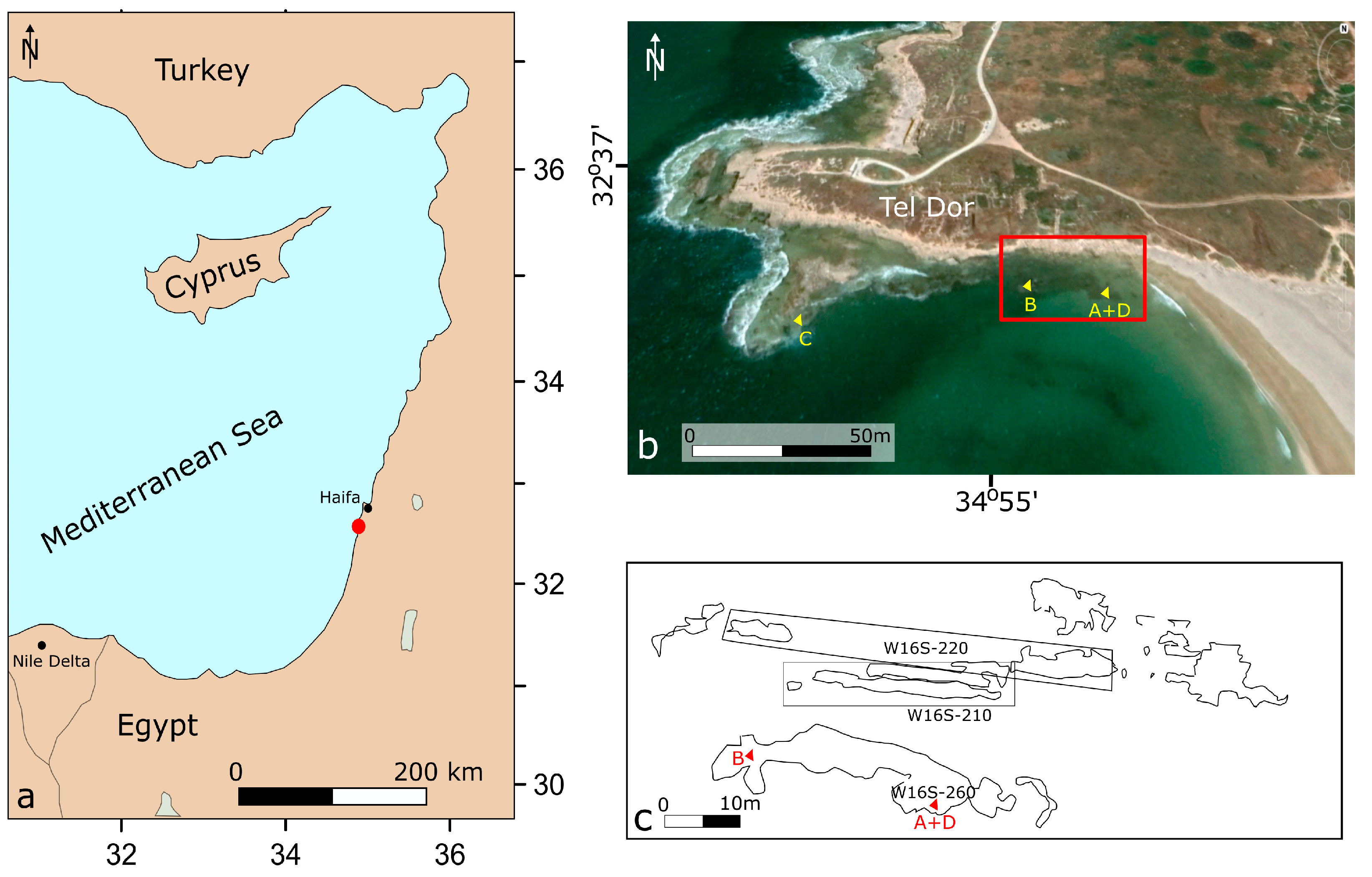
2. Study Area
2.1. Geological Background
2.2. Archaeological Background
2.3. Climatic and Cultural Background
3. Materials and Methods
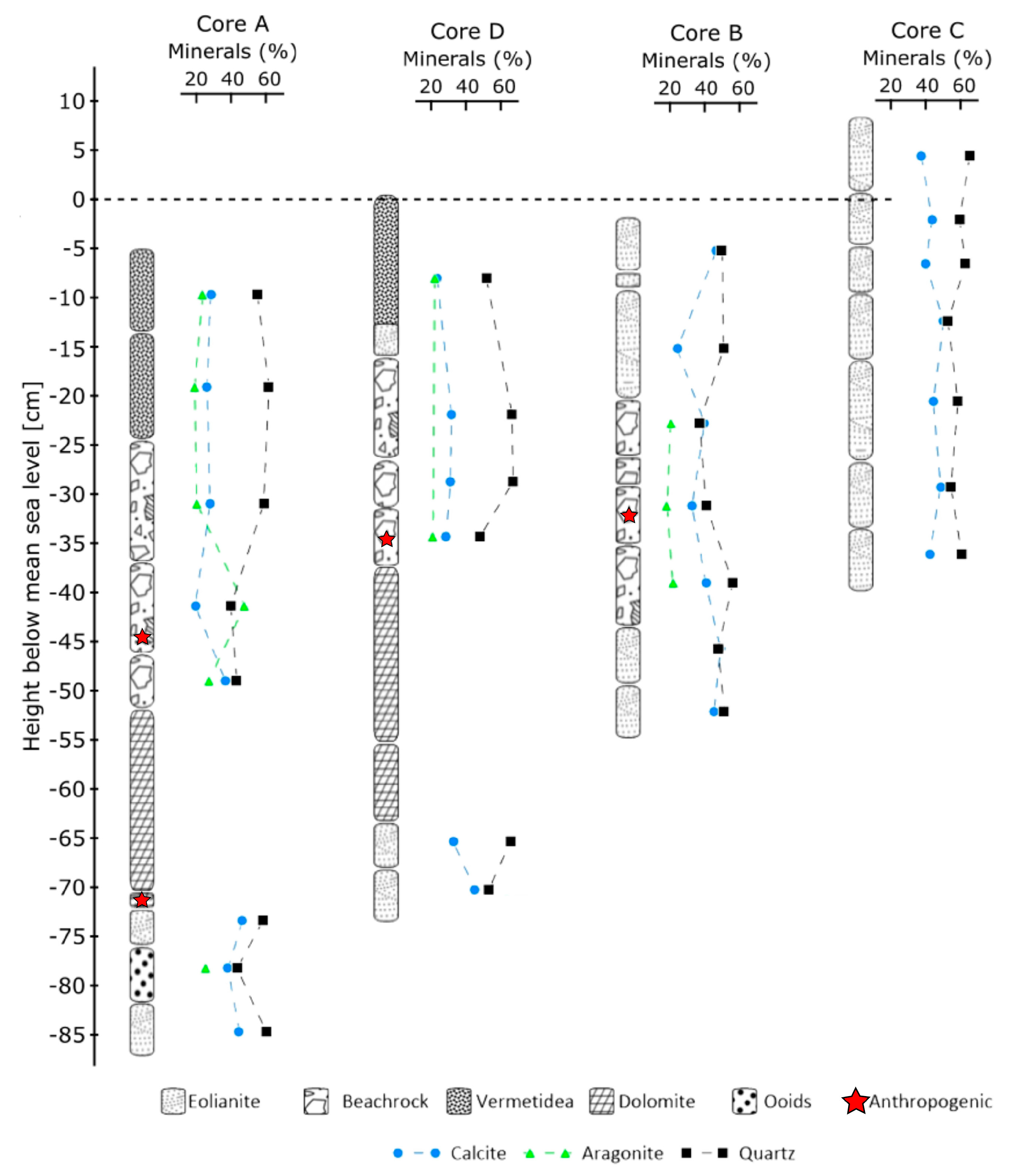
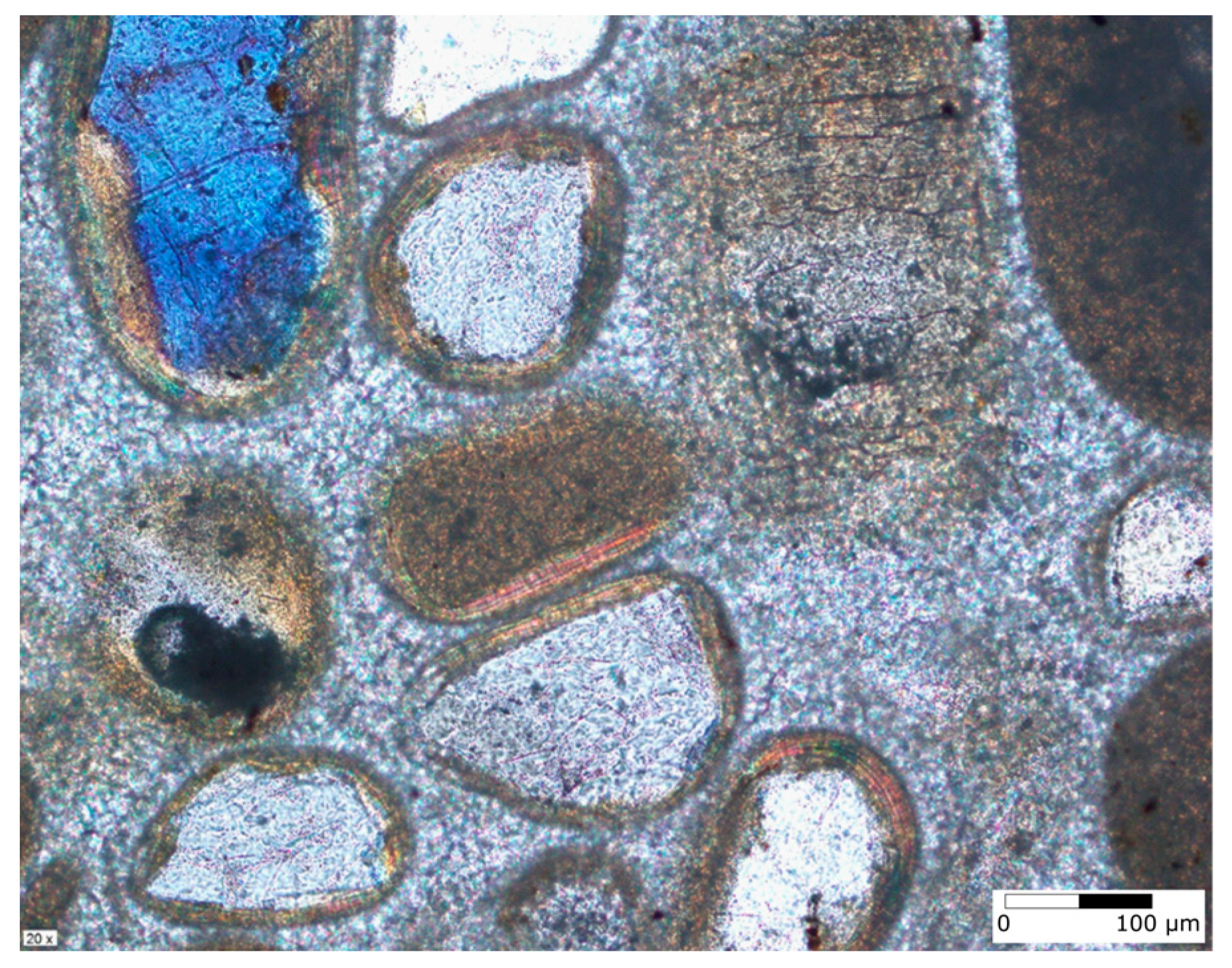
4. Results
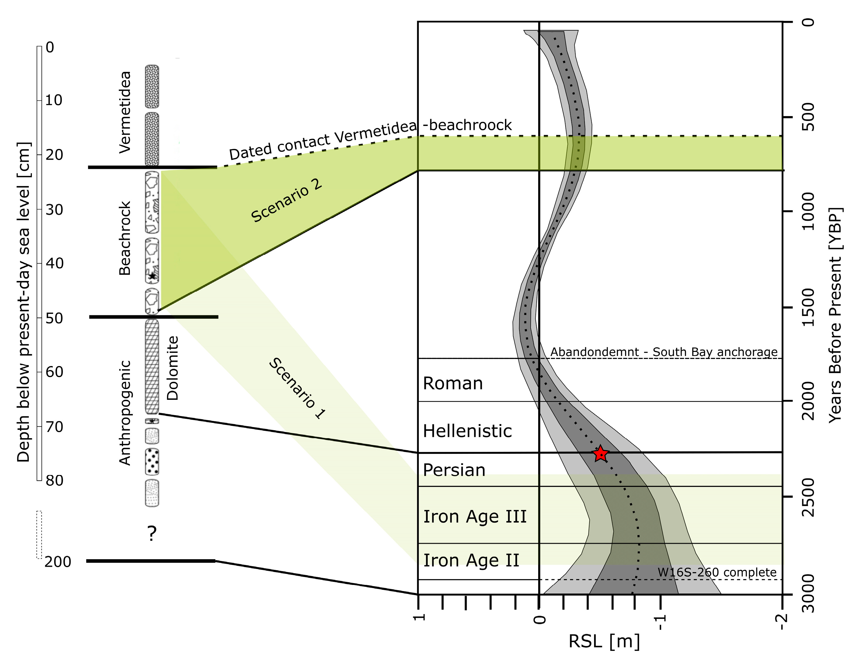
5. Discussion
5.1. Geological Processes
5.2. Anthropogenic Influence
5.3. Towards a Chronology
5.4. A Word about Engineering
6. Conclusions
Author Contributions
Funding
Institutional Review Board Statement
Informed Consent Statement
Data Availability Statement
Acknowledgments
Conflicts of Interest
References
- Marriner, N.; Morhange, C.; Kaniewski, D.; Carayon, N. Ancient harbour infrastructure in the Levant: Tracking the birth and rise of new forms of anthropogenic pressure. Sci. Rep. 2014, 4, 5554. [Google Scholar] [CrossRef] [PubMed] [Green Version]
- Morhange, C.; Giaime, M.; Marriner, N.; Hamid, A.A.; Bruneton, H.; Honnorat, A.; Kaniewski, D.; Magnin, F.; Porotov, A.V.; Wante, J.; et al. Geoarchaeological evolution of Tel Akko’s ancient harbour (Israel). J. Archaeol. Sci. Rep. 2016, 7, 71–81. [Google Scholar] [CrossRef]
- Raban, A.; Artzy, M.; Goodman, B.; Gal, Z. (Eds.) The Harbour of Sebastos (Caesarea Maritima) in Its Roman Mediterranean Context; BAR International Series 1930; Archeopress: Oxford, UK, 2009; 222p, ISBN1 10: 1407304127/1-4073-0412-7. ISBN2 13: 9781407304120. [Google Scholar]
- Preiser-Kapeller, J. Harbours and maritime networks as complex adaptive systems—A thematic introduction. In Harbours and Maritime Networks as Complex Adaptive Systems; Preiser-Kapeller, J., Daim, F., Eds.; Verlag des Römisch-Germanisches Zentralmuseum: Mainz, Germany, 2015; pp. 1–23. [Google Scholar]
- Goodman-Tchernov, B.; Katz, O. Holocene-era submerged notches along the southern Levantine coastline: Punctuated sea level rise? Quat. Int. 2016, 401, 17–27. [Google Scholar] [CrossRef]
- Ruggieri, R.; De Waele, J. Lower-to Middle Pleistocene flank margin caves at Custonaci (Trapani, NW Sicily) and their relation with past sea levels. Acta Carsologica 2014, 43, 11–22. [Google Scholar] [CrossRef]
- Borzì, L.; Anfuso, G.; Manno, G.; Distefano, S.; Urso, S.; Chiarella, D.; Di Stefano, A. Shoreline evolution and environmental changes at the NW area of the Gulf of Gela (Sicily, Italy). Land 2021, 10, 1034. [Google Scholar] [CrossRef]
- Distefano, S.; Gamberi, F.; Borzì, L.; Di Stefano, A. Quaternary coastal landscape evolution and sea-level rise: An example from South-East Sicily. Geosciences 2021, 11, 506. [Google Scholar] [CrossRef]
- Distefano, S.; Gamberi, F.; Baldassini, N.; Di Stefano, A. Quaternary evolution of coastal plain in response to sea-level changes: Example from South-East Sicily (Southern Italy). Water 2021, 13, 1524. [Google Scholar] [CrossRef]
- Sisma-Ventura, G.; Guzner, B.; Yam, R.; Fine, M.; Shemesh, A. The reef builder gastropod Dendropoma petreaum—A proxy of short and long term climatic events in the Eastern Mediterranean. Geochim. Cosmochim. Acta 2009, 73, 4376–4383. [Google Scholar] [CrossRef]
- Sivan, D.; Schattner, U.; Morhange, C.; Boaretto, E. What can a sessile mollusk tell about neotectonics? Earth Planet. Sci. Lett. 2010, 296, 451–458. [Google Scholar] [CrossRef]
- Sivan, D.; Wdowinski, S.; Lambeck, K.; Galili, E.; Raban, A. Holocene sea-level changes along the Mediterranean coast of Israel, based on archaeological observations and numerical model. Palaeogeogr. Palaeoclimatol. Palaeoecol. 2001, 167, 101–117. [Google Scholar] [CrossRef]
- Yasur-Landau, A.; Shtienberg, G.; Gambash, G.; Spada, G.; Melini, D.; Arkin-Shalev, E.; Tamberino, A.; Reese, J.; Levy, T.E.; Sivan, D. New relative sea-level (RSL) indications from the Eastern Mediterranean: Middle Bronze Age to the Roman period (~3800–1800 y BP) archaeological constructions at Dor, the Carmel coast, Israel. PLoS ONE 2021, 16, e0251870. [Google Scholar] [CrossRef] [PubMed]
- Rivera-Collazo, I.; Ramos-Vélez, M.; Rodríguez-Delgado, E.; Cantú, K. The power of archaeology to address interpretation biases in modern geomorphology. Geomorphology 2021, 389, 107843. [Google Scholar] [CrossRef]
- Fernandinoa, G.; Elliff, C.I.; Francischini, H.; Dentzien-Dias, P. Anthropoquinas: First description of plastics and other man-made materials in recently formed coastal sedimentary rocks in the southern hemisphere. Mar. Pollut. Bull. 2020, 154, 111044. [Google Scholar] [CrossRef] [PubMed]
- Yaalon, D.H. Factors affecting the lithification of eolianite and interpretation of its environmental significance in the coastal plain of Israel. J. Sediment. Res. 1967, 37, 1189–1199. [Google Scholar] [CrossRef]
- Gavish, E.; Friedman, G.M. Progressive diagenesis in Quaternary to Late Tertiary carbonate sediments: Sequence and time scale. J. Sediment. Res. 1969, 39, 980–1006. [Google Scholar]
- Friedman, G.M. Holocene chronostratigraphic beachrocks and their geologic climatic significance. Geochem. Soc. Spec. Publ. 2004, 9, 125–142. [Google Scholar] [CrossRef]
- Galili, E.; Zviely, D.; Ronen, A.; Mienis, H.K. Beach deposits of MIS 5e high sea stand as indicators for tectonic stability of the Carmel coastal plain, Israel. Quat. Sci. Rev. 2007, 26, 2544–2557. [Google Scholar] [CrossRef]
- Moore, C.H. Intertidal carbonate cementation Grand Cayman, West Indies. J. Sediment. Res. 1973, 43, 591–602. [Google Scholar]
- Hanor, J.S. Precipitation of beachrock cements: Mixing of marine and meteoric waters vs. CO2-degassing. J. Sediment. Res. 1978, 48, 489–501. [Google Scholar]
- Meyers, J.H. Marine vadose beachrock cementation by cryptocrystalline magnesian calcite—Maui, Hawaii. J. Sediment. Petrol. 1987, 57, 558–570. [Google Scholar]
- Morse, J.W.; Mackenzie, F.T. Geochemistry of Sedimentary Carbonates. Geochemistry Sediment; Developments in Sedimentology 48; Elsevier Science: Amsterdam, The Netherlands, 1990; 706p. [Google Scholar]
- Raban, A. Dor-Yam: Maritime and coastal installations at Dor in their geomorphological and stratigraphic context. In Excavations at Dor. Final Report I, A: Areas A and C. Introduction and Stratigraphy (Qedem Reports I); Stern, E., Ed.; Hebrew University of Jerusalem: Jerusalem, Israel, 1995; pp. 285–354. [Google Scholar]
- Sisma-Ventura, G.; Antonioli, F.; Silenzi, S.; Devoti, S.; Montagna, P.; Chemello, R.; Shemesh, A.; Yam, R.; Gehrels, R.; Dean, S.; et al. Assessing vermetid reefs as indicators of past sea levels in the Mediterrnaen. Mar. Geol. 2020, 429, 106313. [Google Scholar] [CrossRef]
- Stern, E. Dor, the Ruler of the Seas: Nineteen Years of Excavations at the Israelite-Phoenician Harbor Town on the Carmel Coast; Israel Exploration Society: Jerusalem, Israel, 2000; 400p. [Google Scholar]
- Yasur-Landau, A. The archaeology of maritime adaptation. In The Social Archaeology of the Levant: From Prehistory to the Present; Yasur-Landau, A., Cline, E., Rowan, Y., Eds.; Cambridge University Press: Cambridge, UK, 2019; pp. 551–570. [Google Scholar] [CrossRef]
- Arkin Shalev, E.; Yasur-Landau, A.; Gilboa, A. The Iron Age Maritime Interface at the South Bay of Tel Dor: Results from the 2016 and 2017 excavation seasons. Int. J. Naut. Archaeol. 2019, 48, 439–452. [Google Scholar] [CrossRef]
- Lazar, M.; Engoltz, K.; Basson, U.; Yasur-Landau, A. Water saturated sand and a shallow bay: Combining coastal geophysics and underwater archaeology in the south bay of Tel Dor. Quat. Int. 2018, 473, 112–119. [Google Scholar] [CrossRef]
- Kingsley, S.A.; Raveh, K. The Ancient Harbour and Anchorage at Dor, Israel. Results of the Underwater Surveys 1976–1991; Bar Publishing: Oxford, UK, 1997; 264p. [Google Scholar]
- Arkin Shalev, E.; Gambash, G.; Yasur-Landau, A. Disheveled tenacity: The north bay of Roman and Byzantine Dor. J. Marit. Archaeol. 2019, 14, 205–237. [Google Scholar] [CrossRef]
- Shtienberg, G.; Gadol, O.; Levy, T.E.; Norris, R.D.; Yasur-Landau, A.; Rittenour, T.M.; Tamberino, A.; Lazar, M. Changing environments and human interaction during the Pleistocene—Early Holocene from the shallow coastal area of Dor, Israel. Quat. Res. 2022, 105, 64–81. [Google Scholar] [CrossRef]
- Sivan, D.; Eliyahu, D.; Raban, A. Late Pleistocene to Holocene wetlands now covered by sand, along the Carmel Coast, Israel, and their relation to human settlement: An example from Dor. J. Coast. Res. 2004, 204, 1035–1048. [Google Scholar] [CrossRef]
- Shtienberg, G.; Yasur-Landau, A.; Norris, R.D.; Lazar, M.; Rittenour, T.M.; Tamberino, A.; Gadol, O.; Cantu, K.; Arkin Shalev, U.; Goblin, I.; et al. A Neolithic mega-tsunami event in the eastern Mediterranean: Prehistoric settlement vulnerability along the Carmel Coast, Israel. PLoS ONE 2020, 15, e0243619. [Google Scholar] [CrossRef]
- Galili, E.; Zviely, D. Geo-archaeological markers reveal magnitude and rates of Israeli coastal cliff erosion and retreat. J. Coast. Conserv. 2019, 23, 747–758. [Google Scholar] [CrossRef]
- Mor, H.; Kahanov, Y. The Dor 2001/1 shipwreck, Israel—A summary of the excavation. Int. J. Naut. Archaeol. 2006, 35, 274–289. [Google Scholar] [CrossRef]
- Waiman-Barak, P.; Gilboa, A.; Goren, Y. A stratified sequence of Early Iron Age Egyptian ceramics at Tel Dor, Israel. Agypt. Levante 2014, 24, 315–342. [Google Scholar] [CrossRef]
- Gilboa, A. Dor and Egypt in the early Iron Age: An archaeological perspective of (part of) the Wenamun report. Agypt. Levante 2015, 24, 315–342. [Google Scholar] [CrossRef]
- Yasur-Landau, A. The memory machine: How 12th-century BCE iconography created memories of the philistines (and other sea peoples). In MNHMH/MNEME. Past and Memory in the Aegean Bronze Age Proceedings of the 17th International Aegean Conference, University of Udine, Department of Humanities and Cultural Heritage, Ca’ Foscari University of Venice, Department of Humanities, 17-21 April 2018, Aegaeum 43; Peeters Publishers: Leuven, Belgium, 2019; pp. 413–422. [Google Scholar]
- Gilboa, A.; Sharon, I. Between the Carmel and the sea: Tel Dor’s Iron Age reconsidered. Near East. Archaeol. 2008, 71, 146–170. [Google Scholar] [CrossRef]
- Sharon, I.; Gilboa, A. The SKL town: Dor in the Early Iron Age. In The Philistines and Other “Sea Peoples” in Text and Archaeology; Killebrew, A.E., Lehmann, G., Eds.; The Society of Biblical Literature: Atlanta, GA, USA, 2013; pp. 393–468. [Google Scholar]
- Galili, E.; Rosen, B. Fishing gear from a 7th-century shipwreck off Dor, Israel. Int. J. Naut. Archaeol. 2008, 37, 67–76. [Google Scholar] [CrossRef]
- Haggi, A. Report on underwater excavation at the Phoenician harbour, Atlit, Israel. Int. J. Naut. Archaeol. 2010, 39, 278–285. [Google Scholar] [CrossRef]
- Langgut, D.; Finkelstein, I.; Litt, T. Climate and the Late Bronze collapse: New evidence from the southern Levant. Tel Aviv 2013, 40, 149–175. [Google Scholar] [CrossRef]
- Nitschke, J.L.; Martin, S.R.; Shalev, Y. Between Carmel and the sea: Tel Dor: The late periods. Near East. Archaeol. 2011, 74, 132–154. [Google Scholar] [CrossRef]
- Dean, S.; Horton, B.P.; Evelpidou, N.; Cahill, N.; Spada, G.; Sivan, D. Can we detect centennial sea-level variations over the last three thousand years in Israeli archaeological records? Quat. Sci. Rev. 2019, 210, 125–135. [Google Scholar] [CrossRef]
- Guinier, A. X-ray Crystallographic Technology; Hilger and Watts: London, UK, 1952; 343p. [Google Scholar]
- Hubbard, C.R.; Snyder, R.L. RIR-Measurement and use in quantitative XRD. Powder Diffr. 1988, 3, 74–77. [Google Scholar] [CrossRef] [Green Version]
- Gates-Rector, S.; Blanton, T. The Powder Diffraction File: A quality materials characterization database. Powder Diffr. 2019, 34, 352–360. [Google Scholar] [CrossRef] [Green Version]
- Gilboa, A.; Sharon, I. An archaeological contribution to the early Iron Age chronological debate: Alternative chronologies for Phoenicia and their effects on the Levant, Cyprus and Greece. Bull. Am. Sch. Orient. Res. 2003, 332, 7–80. [Google Scholar] [CrossRef]
- Sharon, I.; Gilboa, A.; Jull, A.J.T.; Boaretto, E. Report on the First Stage of the Iron Age Dating Project in Israel: Supporting a Low Chronology. Radiocarbon 2007, 49, 1–46. [Google Scholar] [CrossRef] [Green Version]
- Mauz, B.; Vacchi, M.; Green, A.; Hoffmann, G.; Cooper, A. Beachrock: A tool for reconstructing relative sea level in the far-field. Mar. Geol. 2015, 362, 1–16. [Google Scholar] [CrossRef]
- Wachsmann, S.; Raveh, K. A concise nautical history of Dor/Tantura. Int. J. Naut. Archaeol. 1984, 13, 223–241. [Google Scholar] [CrossRef]
- Swarzenski, P.W.; Burnett, W.C.; Greenwood, W.J.; Herut, B.; Peterson, R.; Dimova, N.; Shalem, Y.; Yechieli, Y.; Weinstein, Y. Combined time-series resistivity and geochemical tracer techniques to examine submarine groundwater discharge at Dor Beach, Israel. Geophys. Res. Lett. 2006, 33, L24405. [Google Scholar] [CrossRef]
- Haggi, A.; Artzy, M. The harbor of Atlit in northern Canaanite/Phoenician context. Near East. Archaeol. 2007, 70, 75–84. [Google Scholar] [CrossRef]
- Fabricius, F.H.; Berdau, D.; Münnich, K.O. Early Holocene oöids in modern littoral sands reworked from a coastal terrace, southern Tunisia. Science 1970, 169, 757–760. [Google Scholar] [CrossRef]
- Lakhdar, R.; Soussi, M.; Ben Ismail, M.H.; M’Rabet, A. A Mediterranean Holocene restricted coastal lagoon under arid climate: Case of the sedimentary record of Sabkha Boujmel (SE Tunisia). Palaeogeogr. Palaeoclimatol. Palaeoecol. 2006, 241, 177–191. [Google Scholar] [CrossRef]
- Mauz, B.; Fanelli, F.; Elmejdoub, N.; Barbieri, R. Coastal response to climate change: Mediterranean shorelines during the Last Interglacial (MIS 5). Quat. Sci. Rev. 2012, 54, 89–98. [Google Scholar] [CrossRef]
- Almagor, G.; Perath, I. The Mediterranean Sea Coast of Israel. In Geological Survey of Israel Report GSI/28/2012, 3rd ed.; Geological Survey of Israel: Jerusalem, Israel, 2012; 438p. (In Hebrew) [Google Scholar]
- Dan, J.; Yaalon, D.H. Trends in soil development with time in the Mediterranean environments of Israel. In Transaction of the Conference on Mediterranean Soils; SECS: Madrid, Spain, 1966; pp. 139–145. [Google Scholar]
- Lazar, M.; Basson, U.; Himmelstein, A.G.; Levy, T.E.; Arkin Shalev, U.; Yasur-Landau, A. The door to Dor: Tracing unseen anthropogenic impact on an ancient port. Geoarchaeology 2021, 36, 203–212. [Google Scholar] [CrossRef]


| Period (and Archaeological Culture) | Chronology Tel Dor [ref] | Climate [41] | Sea Level (below Present-Day Level) |
|---|---|---|---|
| Middle Bronze Age I (Canaanite) | 1950–1750 BCE [40] | Dry | approx. −3 m [13] |
| Middle Bronze Age II-III (Canaanite) | 1750–1550 BCE [40] | More Humid | |
| Late Bronze Age (Canaanite) | 1550–1200/1150 BCE [40] | Humid, but later dry climate event ca. 1300–1200 BCE | approx. −2.5 m? [13] |
| Iron Age Ia, (late Canaanite—Phoenician) | 1200/1150–1100/1050 BCE [40] | Humid | approx. −2 m [13] |
| Iron Age Ib (late Canaanite—Phoenician) | 1100/1050–925/900 BCE [40] | Humid | approx. −2 m [13] |
| Transition Iron Age Ib-II (Phoenician) | 925–875 BCE [40] | Humid | −1.5 m [46] |
| Iron IIa and IIb (Phoenician, Israelite) | 900–700 BCE [40] | Drier | Stable [46] |
| Iron Age IIc (Iron Age III) | 700–586/500 BCE [40] | Drier | |
| Persian Period (Phoenician) | 500–300 BCE [45] | ? | Stable [46] |
| Hellenistic Period | 300–50/1 BCE [45] | ? | Rises rapidly [46] |
| Roman Period * | 1 BCE–222/250 CE (?) |
Disclaimer/Publisher’s Note: The statements, opinions and data contained in all publications are solely those of the individual author(s) and contributor(s) and not of MDPI and/or the editor(s). MDPI and/or the editor(s) disclaim responsibility for any injury to people or property resulting from any ideas, methods, instructions or products referred to in the content. |
© 2023 by the authors. Licensee MDPI, Basel, Switzerland. This article is an open access article distributed under the terms and conditions of the Creative Commons Attribution (CC BY) license (https://creativecommons.org/licenses/by/4.0/).
Share and Cite
Nachum, O.; Bialik, O.; Basson, U.; Yasur-Landau, A.; Lazar, M. The Anthropogenic Affect—Humans and Geology: An Example from Tel Dor, Israel. J. Mar. Sci. Eng. 2023, 11, 283. https://doi.org/10.3390/jmse11020283
Nachum O, Bialik O, Basson U, Yasur-Landau A, Lazar M. The Anthropogenic Affect—Humans and Geology: An Example from Tel Dor, Israel. Journal of Marine Science and Engineering. 2023; 11(2):283. https://doi.org/10.3390/jmse11020283
Chicago/Turabian StyleNachum, Omry, Or Bialik, Uri Basson, Assaf Yasur-Landau, and Michael Lazar. 2023. "The Anthropogenic Affect—Humans and Geology: An Example from Tel Dor, Israel" Journal of Marine Science and Engineering 11, no. 2: 283. https://doi.org/10.3390/jmse11020283