Article

The Tanais Bay of the Eastern Paratethys Sea at the Sarmatian–Maeotian Transition (Late Miocene): Widespread Desiccations and Local Uplifts in the Light of Historical Information

K.G. Razumovsky Moscow State University of Technologies and Management (The First Cossack University), Zemlyanoy Val Street 73, Moscow 109004, Russia
J. Mar. Sci. Eng. 2022, 10(7), 915; https://doi.org/10.3390/jmse10070915
Submission received: 9 June 2022 / Revised: 27 June 2022 / Accepted: 29 June 2022 / Published: 1 July 2022
(This article belongs to the Special Issue Recent Advances in Geological Oceanography)

Abstract

:
The Late Miocene evolution of the Eastern Paratethys Sea was marked by significant palaeogeographical transformations. The knowledge of them should be improved with the information from the peripheral parts of this semi-enclosed marine basin. The study area corresponds to the Rostov Dome where the northern shore of the Eastern Paratethys is widely documented. The information from the previously published work, going back to the beginning of the 20th century, is collected. Its analysis allows us to document the spatial distribution of Middle Sarmatian–Late Maeotian (Tortonian–Messinian) deposits. The results shed light into the palaeogeographical changes in the Tanais Bay of the Eastern Paratethys Sea, which included the short-term hiatus at the Middle/Late Sarmatian boundary, the Early Maeotian regression, and the gradual Late Maeotian ingression when the bay re-established, but with a different configuration. These changes and the overall spatial distribution of the studied deposits cannot be explained by only the fluctuations in the level of the Eastern Paratethys and the desiccation episodes established in its central part. Most probably, the local tectonic uplifts were an important driver of the Late Miocene evolution of the Tanais Bay.

1. Introduction

The northern periphery of the former Neo-Tethys Ocean experienced significant re-organizations, together with the growth of the Alpine tectonic belt, in the second half of the Cenozoic [1,2,3]. One outcome of these processes was the formation of a huge elongated water mass, namely the Paratethys, which stretched from West Europe to Central Asia [4,5,6,7,8,9,10]. The Paratethys was partly (and, temporarily, fully) isolated from the World Ocean, and it was also fragmented into several basins occupied by seas, some of which looked like megalakes [6,11]. Its eastern portion is known as the Eastern Paratethys Sea (palaeosea) [11,12,13]. In the Late Miocene, this was the well-shaped interior sea located between the Russian Platform in the north, Anatolia in the south, the Carpathian domain in the west, and the Turan Platform in the east (Figure 1). It consisted of several sedimentary basins [11].
To date, there has been significant progress in the understanding of the Late Miocene evolution of the Eastern Paratethys. Particularly, much has become known about its disconnections [13], strong unbalances of water budget [6], astronomical cycles [14,15], salinity changes [16], and interaction of eustasy and tectonic activity [17]. However, a significant part of this information has been accumulated in the central and southern parts of the palaeosea, i.e., in the Euxine Basin. The stratigraphical records of the peripheral, nearshore domains can provide another portion of knowledge, which can extend the understanding of this palaeosea’s evolution. One very suitable locality for such investigations is situated on the northern periphery of the Ciscaucasian Basin, where a wide, shallow-water bay existed in the Late Miocene. This is known as the Tanais Bay (palaeobay). Tanais was the Ancient Greek name of the Don River and the ancient settlement near the mouth of this river [18,19]. At the end of the 19th century, the name Tanais Bay was introduced by Sokolov [20] to characterize the palaeogeographical feature where the specific Late Miocene deposits accumulated (the presence of this wide bay is reflected by the modern reconstructions [11]). During more than a century of subsequent research, the information about these deposits grew, although some questions remain unanswered, and even the configuration of the palaeobay is unclear. The current understanding of the stratigraphy of the Late Miocene deposits of the Tanais Bay is presented by Ruban [21,22,23]. It should be noted that lithologies and the related depositional environments in this palaeobay are already well-established, but serious biases exist in the understanding of the depositional architecture. These biases prevent accurate palaeogeographical reconstructions.
The aim of the present work is to reveal the palaeogeographical changes in the Tanais Bay at the Sarmatian–Maeotian (Tortonian–Messinian) transition through examination of the spatial distribution of the related sedimentary bodies. It is documented in regard to what has been learned about both reference sections and numerous small, similar-looking outcrops during about a century of research (attention is not paid to the correlation of the reference sections already completed by Ruban [22]). The outcomes of such an analysis permit comparison of the records from the palaeosea’s periphery (Tanais Bay) and its internal part in order to form judgments about such notable events as basin desiccations [6]. In other words, the present paper clarifies the local evolution of the Tanais Bay for subsequently making more general conclusions. A specific and unusual aspect of this analysis is its focus on various information which has been accumulated during about a century and needs to be summarized. Many of the previous works are already too old and difficult to access. Moreover, they focus chiefly on small outcrops (the majority of these works result from geological mapping, not from stratigraphical investigations); as a result, these works were often missed. However, this old information is essential because the study area experienced significant anthropogenic modification linked to the urban sprawl in the second half of the 20th century (now, Rostov-on-Don has a population exceeding one million people, and there are other big settlements in its vicinity), and landslides also destroyed many outcrops. Thus, the earlier accumulated information cannot be recompensed with the new investigations. The present study is the first attempt to treat all these lines of historical evidence together, to systematize them, and to justify according to the latest stratigraphical developments.

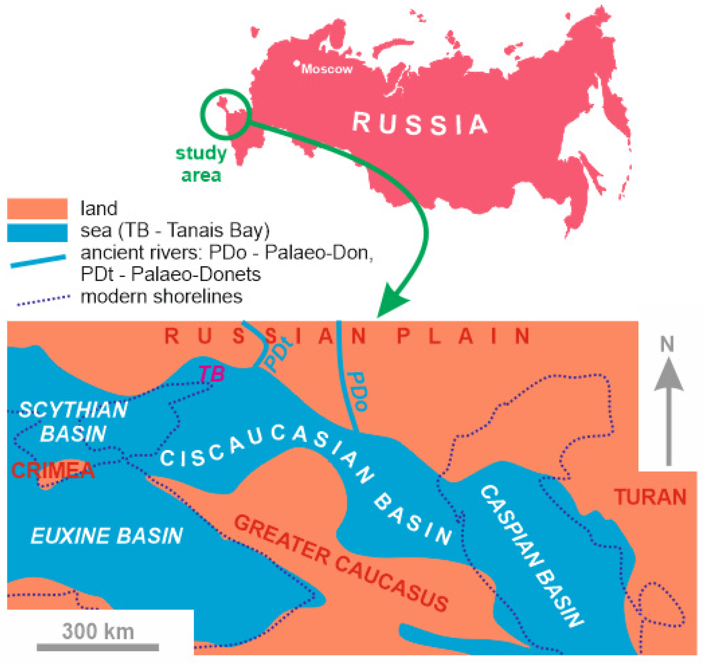
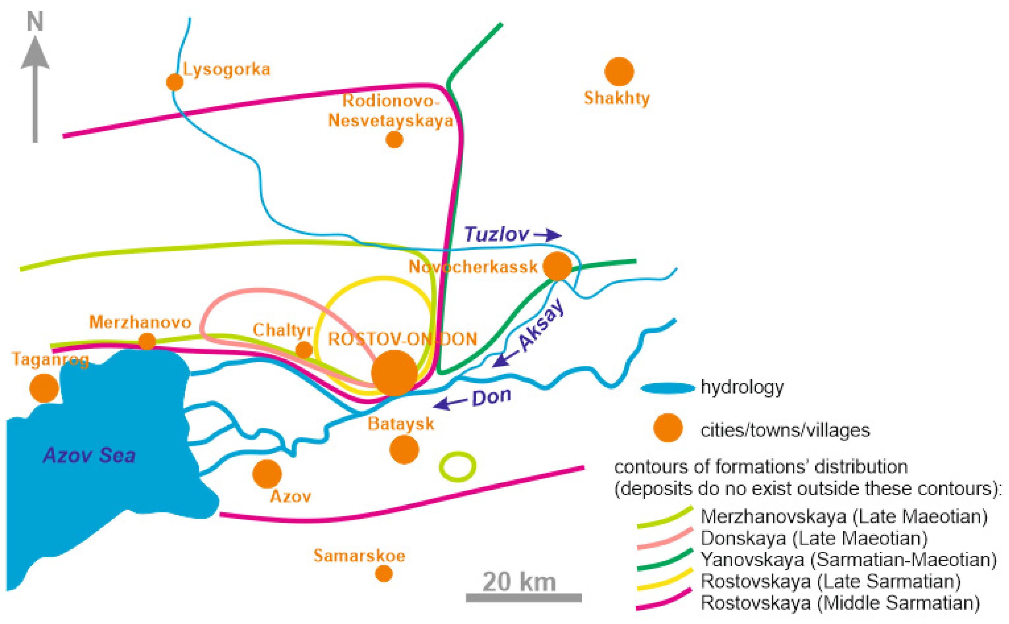
2. Geological Setting

Geographically, the study area is situated in the southwestern part of the Rostov Region of the Russian Federation, where the large Don River enters the Taganrog Bay of the Azov Sea. It belongs to the southern edge of the Russian Platform (a Precambrian craton with rather thick sedimentary cover) and, particularly, the Rostov Dome, which is a Cenozoic anticline structure characterized by Belov et al. [24], Ivanitskaya and Pogrebnov [25], Kostyuchenko et al. [26], and Ruban [27]. The Precambrian crystalline basement is unconformably covered by Cretaceous mixed siliciclastic–carbonate deposits with a total thickness of ~400 m. They are overlaid by ~750 m of Paleogene–Middle Miocene sandstones and shales. Late Miocene deposits are represented by skeletal limestones, clays, and sands with a total thickness of ~100 m, and they are overlaid by Pliocene–Quaternary sands and clays exceeding 100 m in thickness. Pre-Pliocene deposits are chiefly marine, while the younger strata are continental.
The high right bank of the wide river’s valley and the steep, landslide-affected slopes of the bay represent a lengthy “ribbon” of outcrops of the Late Miocene deposits [22]. There are also numerous small outcrops scattered in the study area. The Late Miocene deposits are represented by several lithostratigraphical units, namely the Taganrogskaya, Rostovskaya, Yanovskaya, Donskaya, Merzhanovskaya, and Aleksandrovskaya formations [21]. Their vertical and lateral relationships, composition, and depositional environments are summarized in Figure 2.
The age of the above-mentioned formations was established precisely with bivalves by Ruban [22,23]. Importantly, this age is justified to the regional stages, i.e., the geological time units developed for the Eastern Paratethys by generations of Soviet and Russian geologists. The relation of these regional stages to the standard stages of the Neogene formalized by the International Commission on Stratigraphy [28,29] has remained uncertain for decades. However, the present investigations, the outcomes of which are shown by Palcu et al. [6] and Popov et al. [13], allow us to correlate the regional and standard stages with precision (Figure 2).
Palaeogeographically, the study area belonged to the northern margin of the Eastern Paratethys (Figure 1). In the Late Miocene, the western and central parts of the Rostov Dome were occupied by the shallow-water Tanais Bay where skeletal limestones, sands, and clays deposited, whereas the eastern part was dominated by the fluvial plain and the delta of the Palaeo-Donets River, where relatively thick fluvial sands accumulated [22,23]. It should be noted that the local hydrology has experienced significant changes since the Miocene. The modern Don River flows from the east to the west to reach the Azov Sea. It has a right tributary, namely the Seversky Donets River, with its mouth located to the east of the study area. In the Miocene, these were two different river systems, namely the Palaeo-Don and the Palaeo-Donets [11]. They both ran from the north to the south to reach directly the Eastern Paratethys Sea. The Palaeo-Donets was situated relatively close to the Tanais Bay.

3. Materials and Methods

The present work employs two kinds of materials. First, these are observations of the spatial distribution of the Middle Sarmatian–Maeotian deposits made by the author in the course of field investigations in the Rostov Dome. Although the related descriptions and the correlations of fourteen reference sections were already published [21,22,23], this information can be re-considered together with the other data for more accurate palaeogeographical reconstructions. Second, the previous investigations (since the beginning of the 20th century) have accumulated vast knowledge about the spatial distribution of the Middle Sarmatian–Maeotian deposits, including those plots, which are densely-urbanized now and where the outcrops were either destroyed or became fully inaccessible due to infrastructure development. The outcomes of these previous investigations were published by Belov et al. [24], Ivanitskaya and Pogrebnov [25], Bogachev [30,31,32], Kolesnikov [33], Miroshnikov [34], Nalivkin and Sokolov [35], Paffengolts [36], and Vlasov [37,38,39]. They provide information about a few dozen individual outcrops and groups of outcrops. Additionally, these three palaeogeographical schemes, presented by Vlasov [37,38,39], are very important.
The collected information has been summarized so as to depict the spatial distribution of the Rostovskaya, Yanovskaya, Donskaya, and Merzhanovskaya formations, which represent the Sarmatian–Maeotian transition (Figure 2). In the case of the Rostovskaya Formation, its Middle Sarmatian and Late Sarmatian parts are considered separately due to the already known striking differences in their distribution [22]. For each unit, the areas of its presence and absence are documented on the basis of the available knowledge (see above). It should be noted that some old sources do not name outcrops, but often indicate the plots where the particular deposits are present, i.e., they provide the already generalized information (to avoid dealing with individual sections and outcrops was a very typical style of reporting lithostratigraphical data until the 1990s). Ignoring this information would be wrong, particularly, because the precision of these previous investigations was usually high (Figure 2). Synthesizing the available information permits us to establish contours of the spatial distribution of each above-mentioned formation in the Rostov Dome. This state-of-the-art synthesis also solves the other problem linked to the “scattered” representation of the formations in multiple outcrops, which are difficult (if possible) to correlate. The contours are shown on the same scheme of the Rostov Dome, which allows an understanding of the lateral and vertical relations of the sedimentary bodies. This scheme is essential for qualitatively deciphering the complex depositional architecture of the Late Miocene deposits of the study area.

4. Results

The performed synthesis of the available knowledge (see sources above) implies that the Rostovskaya, Yanovskaya, Donskaya, and Merzhanovskaya formations differ significantly by their spatial distribution (Figure 3). The entire geological time interval of their deposition lasted only ~4 Ma (Figure 2), which implies significant palaeogeographical changes and, thus, general dynamism of the Tanais Bay. Such a finding is expected, taking into account its peripheral position and very small depth [11,38,39].
The Middle Sarmatian part of the Rostovskaya Formation is the most widely distributed. It occurs in the central, western, and southern parts of the study area (Figure 3). Most probably, these deposits also existed between Rostov-on-Don and Samarskoe, but they were totally eroded later, together with the deep incision of the wide valley of the modern Don River in the Pliocene–Quaternary (this incision exceeded 100 m). This formation is absent in the east of the study area, where the Yanovskaya Formation occurs. (Although one can hypothesize that the Yanovskaya Formation extended westwards, as a “tongue” between Rostov-on-Don and Samarskoe, there is not any evidence to support this idea.) The boundary between the areas of distribution of the Rostovskaya and Yanovskaya formations is a strait. The Late Sarmatian part of the Rostovskaya Formation and the Donskaya Formation are distinguished by very restricted distribution in the central part of the study area. The Merzhanovskaya Formation embraces a larger area, but its northern limit corresponds to the valley of the Tuzlov River, i.e., it is much less distributed than the Middle Sarmatian deposits (Figure 3). Notably, this formation crops out very locally to the southeast of Bataysk, which fact indicates its possible presence between Rostov-on-Don and Bataysk, where it was eroded in the Pliocene–Quaternary together with the Don River valley’s development. In the southern part of the Rostov Dome, the Sarmatian deposits are unconformably overlaid by the Pontian deposits, i.e., the Maeotian deposits do not exist there.
In addition to the spatial distribution of the noted formations, the compilation of the information from the old sources indicates two hiatuses. The older one took place at the Middle–Late Sarmatian transition, where unconformity associates with intraformational conglomerate beds. The other hiatus started near the end of the Sarmatian and lasted until the mid-Maeotian. Importantly, these hiatuses are registered in the western and central parts of the study area, but not in its eastern part, where alluvial sands of the Yanovskaya Formation accumulated almost continuously until the Late Maeotian.

5. Discussion

5.1. Tracing Palaeogeographical Changes

The synthesized information allows reconstructing the local palaeogeography for four time slices, namely the Middle Sarmatian, the Late Sarmatian, the Early Maeotian, and the Late Maeotian. The lithologies and the related facies/palaeoenvironments are well-known [22,38,39] (Figure 2). The present study focuses on the configuration of the Tanais Bay.
As suggested by the wide distribution of the Middle Sarmatian part of the Rostovskaya Formation and its spatial contacts with the Yanovskaya Formation (Figure 3), the Tanais Bay was a wide feature on the northern periphery of the Eastern Paratethys. It occupied a flat space between the denudated land in the north and the fluvial plain of the Palaeo-Donets River in the east (Figure 4a). This corresponds to the reconstruction by Popov et al. [11]. The denudated land is interpreted because of long-term non-deposition in the northern part of the Rostov Dome and the presence of clastic material in the Sarmatian limestones derived from the adjacent land [39]. Apparently, the fluvial plain was a part of the propagated delta of the Palaeo-Donets River; it is also possible that the deltas of the Palaeo-Donets, the Palaeo-Don, and smaller rivers formed a single fluvial plain which extended far eastwards [11,39]. Notably, the Tanais Bay occupied generally the same (or an even smaller) territory of the Rostov Dome in the Middle Sarmatian relative to the Early Sarmatian (for instance, [37,39]), despite a rather strong transgression in the Eastern Paratethys [12]. This implies that the denudated land north of the Tanais Bay either remained high since the beginning of the Sarmatian or experienced gradual uplift (the mechanism of the latter cannot even be hypothesized). The second option seems to be more probable, taking into account the later scenario (see below).
The Middle–Late Sarmatian transition is marked by the unconformity, which implies regression and temporary bay disappearance. Marine sedimentation restarted very soon. The Late Sarmatian deposits are known locally in the central part of the study area (Figure 3). Apparently, they were also present in its southern part, but were later eroded. To argue this idea, it is necessary to stress that the preceding hiatus was too short to expect significant palaeogeographical re-organization, and, thus, the sea could ingress from the only south. It remains questionable whether the Tanais Bay reached the size comparable to that which it had in the Middle Sarmatian. Apparently, this hypothesis should be rejected, because Kolesnikov [33], who had the opportunity to deal with what is now a densely-urbanized area, explained that the Late Sarmatian conglomerates concentrate in Rostov-on-Don and its vicinities, and their upper surface also demonstrates signs of erosion. Most probably, these beds mark the position of the shoreline, which did not move far northwards. The observations made by Vlasov [38] in the entire northern periphery of the Eastern Paratethys also imply the lesser spatial extent of the Late Sarmatian marine basin. Therefore, the bay was restricted in the Late Sarmatian, but it continued to co-exist with the fluvial plain in the east (Figure 4b).
The sea regressed, and the hiatus corresponded to the entire Early Maeotian. The only Yanovskaya Formation is found in the eastern part of the Rostov Dome (Figure 3). The denudated land prevailed (Figure 4c). The Tanais Bay did not exist in this time slice. One should also note that the level of the Eastern Paratethys was higher in the Early Maeotian, when there was not marine deposition, than in the Late Maeotian, when marine deposition was active [12]. Only tectonic uplift of the dome could prevent bay development in the Early Maeotian. Hypothetically, this uplift started in the Middle Sarmatian, which explains the absence of the wider Middle Sarmatian transgression and the limited distribution of the Late Sarmatian deposits (see above).
The most principal palaeogeographical changes took place in the Late Maeotian (Figure 4d). The sea ingressed from the southwest, and the deposits of the Donskaya Formation accumulated on a restricted plot in the central part of the Rostov Dome (Figure 3). Evidently, their extent was higher, but a portion of them was eroded together with the development of the Don River valley in the Pliocene–Quaternary, and the other portion may exist beneath the Azov Sea. The ingression continued, and the shallow-marine skeletal limestones of the Merzhanovskaya Formation are also known in the western and northern parts of the Rostov Dome (Figure 3). The fluvial plain disappeared (the deposition of the Yanovskaya Formation stopped in the Early Maeotian). Hypothetically, the Palaeo-Donets River migrated eastwards. However, the most striking change was the appearance of some land in the south of the study area, which means the Tanais Bay changed its configuration (Figure 4). There, the Sarmatian deposits are overlain by the Pontian deposits, with unconformity in the southern part of the dome; neither this unconformity, nor the noted absence of the Late Maeotian terrestrial strata, can be explained by any post-Maeotian erosion. There are localities where the Maeotian and Pontian deposits lay conformably and form continuous succession (see discussion in Ruban [23]), and, thus, if there even was an episode of the post-Maeotian erosion, it was short and weak. The only possibility is that the southern and eastern parts of the Rostov Dome experienced tectonic uplifts during the Late Maeotian. The southern and eastern landmass existed until the Early Pontian, when the study area was drowned together with a widespread transgression [12]. Although this is out of scope of the present study, it can be hypothesized that the vertical tectonic motions continued on the northern periphery of the Eastern Paratethys. They could be responsible for the later palaeohydrological reorganizations, after which the Palaeo-Donets River became a tributary of the Don River, and the latter turned its flow direction to the west.

5.2. Basin-Scale Versus Local Events

The three principal palaeogeographical changes in the Tanais Bay at the Sarmatian–Maeotinan transition were (1) the erosion at the Middle/Late Sarmatian boundary, (2) the Early Maeotian sea retreat outside the study area, and (3) the mid-Maeotian ingression and bay reconfiguration. One would expect that the position of this bay on the northern, shallow-water, and tectonically passive periphery of the Eastern Paratethys means that such changes reflect the evolutionary history of the entire sea. This is especially so because the level of the latter experienced strong fluctuations [12]. However, the above-given interpretations indicate both consistencies and inconsistencies of the local and basin-scale records. For instance, the outstanding sea-level fall at the Middle/Late Sarmatian boundary has a direct analogue in the Tanais Bay, whereas the Early Maeotian transgression did not leave any local signature.
On the basis of the information from the central part of the Eastern Paratethys, Palcu et al. [6] established four desiccation episodes (Figure 5). The first and second episodes took place near the Middle/Late Sarmatian boundary. Evidently, these correspond to the sea retreat from the Rostov Dome, where the short-term hiatus took place (Figure 5). In the mid-Late Sarmatian, a rather minor desiccation episode cannot be registered in the study area due to the very thin sedimentary succession of the upper part of the Rostovskaya Formation [6]. The biggest was the episode at the Sarmatian/Maeotian boundary [6] (Figure 5). Apparently, it associated with the start of the long-term erosion in the Rostov Dome. All four episodes characterize the Late Sarmatian evolution of the entire sea. The Tanais Bay had experienced regression since the Middle Sarmatian, and it cannot be excluded that the latter can partly be explained by the general tendency to desiccations in the Eastern Paratethys. However, the interpretations presented above indicate local tectonic activity of an as yet unclear nature (for instance, along major basement faults or epeirogenic) that interplayed with the sea-level changes. For instance, the Eastern Paratethys experienced significant transgression in the Early Maeotian, when terrestrial conditions were typical to the Rostov Dome (Figure 5). The only possible explanation is the local tectonic uplift, which also triggered the later reconfiguration of the Tanais Bay. To trace local tectonic events along the entire northern margin of the Eastern Paratethys and to explain their nature are important tasks for future investigations.
The considered geological time interval corresponds to the late Tortonian (Figure 2), when the Mediterranean (connected, partly connected, or disconnected with the Eastern Paratethys) also experienced serious palaeogeographical transformations. What is really notable is that the local evolution of its peripheries was not only altered by hydrological changes, but demonstrated individual trajectories, often dictated by the local tectonic activity. This seems to be typical to the Mediterranean. For instance, this was established in the Las Minas Basin in Spain [40] and northeastern Tunisia [41]. It appears that the general changes in the water volume in enclosed and semi-enclosed marine basins and mega-lakes should be treated as characteristic to only entire basins, whereas signatures of these changes on basin margins could be altered tectonically. An important question is the mechanism of tectonic uplifts in the Rostov Dome at the Sarmatian–Maeotian transition. Large-scale mechanisms linked to regional evolution [42,43,44] or local vertical motions controlled by faults [26] could be related to such uplifts. However, the present state of the knowledge does not allow definite judgments, and further investigations in the Rostov Dome and the adjacent areas are necessary.

6. Conclusions

The re-examination of the lithostratigraphical knowledge of the Middle Sarmatian–Late Maeotian deposits of the Rostov Dome, undertaken in the light of historical evidence, implies that the Tanais Bay of the Eastern Paratethys Sea experienced significant changes at the Sarmatian–Maeotian transition. The long-term regressive trend culminated in the Early Maeotian when the sea retreated from the study area. Before this, there was a short-term hiatus at the Middle/Late Sarmatian boundary. A transgression started in the Late Maeotian, when the bay had a different configuration. These changes can only partly be linked to the sea-level changes and the desiccation episodes in the Eastern Paratethys. The Tanais Bay was shaped significantly by local forces, including tectonic uplifts.
The present study stresses the methodological importance of analyzing geological archives where old publications, maps, and reports can be stored. Although this old information can be too generalized and somewhat outdated, it can provide unique lines of evidence which cannot be re-collected by new field investigations. This is especially the case of those areas which have experienced dense urbanization and deep anthropogenic modification. It should also be noted that the “classical”, simply-designed lithostratigraphical interpretations still matter in modern palaeogeography, and they seem to be equally important to more advanced microscope- and geochemistry-based analytical techniques.

Funding

This research received no external funding.

Institutional Review Board Statement

Not applicable.

Informed Consent Statement

Not applicable.

Data Availability Statement

Not applicable.

Acknowledgments

The author gratefully thanks the reviewers for their helpful recommendations and O.V. Dudnikova (Russia) for her outstanding help with finding the rare literature sources.

Conflicts of Interest

The author declares no conflict of interest.

References

  1. Golonka, J. Plate tectonic evolution of the southern margin of Eurasia in the Mesozoic and Cenozoic. Tectonophysics 2004, 381, 235–270. [Google Scholar] [CrossRef]
  2. Hässig, M.; Moritz, R.; Ulianov, A.; Popkhadze, N.; Galoyan, G.; Enukidze, O. Jurassic to Cenozoic Magmatic and Geodynamic Evolution of the Eastern Pontides and Caucasus Belts, and Their Relationship With the Eastern Black Sea Basin Opening. Tectonics 2020, 39, e2020TC006336. [Google Scholar] [CrossRef]
  3. Van Hinsbergen, D.J.J.; Torsvik, T.H.; Schmid, S.M.; Matenco, L.C.; Maffione, M.; Vissers, R.L.M.; Gürer, D.; Spakman, W. Orogenic architecture of the Mediterranean region and kinematic reconstruction of its tectonic evolution since the Triassic. Gondwana Res. 2020, 81, 79–229. [Google Scholar] [CrossRef]
  4. Il’ina, L.B. On connections between basins of the Eastern Paratethys and adjacent seas in the middle and late Miocene. Stratigr. Geol. Correl. 2000, 8, 300–305. [Google Scholar]
  5. Magyar, I.; Geary, D.H.; Müller, P. Paleogeographic evolution of the Late Miocene Lake Pannon in Central Europe. Palaeogeogr. Palaeoclimatol. Palaeoecol. 1999, 147, 151–167. [Google Scholar] [CrossRef]
  6. Palcu, D.V.; Patina, I.S.; Sandric, I.; Lazarev, S.; Vasiliev, I.; Stoica, M.; Krijgsman, W. Late Miocene megalake regressions in Eurasia. Sci. Rep. 2021, 11, 11471. [Google Scholar] [CrossRef]
  7. Piller, W.E.; Harzhauser, M.; Mandic, O. Miocene Central Paratethys stratigraphy—Current status and future directions. Stratigraphy 2007, 4, 151–168. [Google Scholar]
  8. Popov, S.V.; Rögl, F.; Rozanov, A.Y.; Steininger, F.F.; Shcherba, I.G.; Kovac, M. Lithological-paleogeographic maps of Paratethys. CFS Cour. Forsch. Senckenberg 2004, 250, 1–46. [Google Scholar]
  9. Rogl, F. Mediterranean and Paratethys. Facts and hypotheses of an Oligocene to Miocene Paleogeography (short overview). Geol. Carpathica 1999, 50, 339–349. [Google Scholar]
  10. Steininger, F.F.; Rögl, F. Paleogeography and palinspastic reconstruction of the Neogene of the Mediterranean and Paratethys. Geol. Soc. Spec. Publ. 1984, 17, 659–668. [Google Scholar] [CrossRef]
  11. Popov, S.V.; Shcherba, I.G.; Ilyina, L.B.; Nevesskaya, L.A.; Paramonova, N.P.; Khondkarian, S.O.; Magyar, I. Late Miocene to Pliocene palaeogeography of the Paratethys and its relation to the Mediterranean. Palaeogeogr. Palaeoclimatol. Palaeoecol. 2006, 238, 91–106. [Google Scholar] [CrossRef]
  12. Popov, S.V.; Antipov, M.P.; Zastrozhnov, A.S.; Kurina, E.E.; Pinchuk, T.N. Sea-level fluctuations on the northern shelf of the Eastern Paratethys in the Oligocene-Neogene. Stratigr. Geol. Correl. 2010, 18, 200–224. [Google Scholar] [CrossRef]
  13. Popov, S.V.; Rostovtseva, Y.V.; Pinchuk, T.N.; Patina, I.S.; Goncharova, I.A. Oligocene to Neogene paleogeography and depositional environments of the Euxinian part of Paratethys in Crimean—Caucasian junction. Mar. Pet. Geol. 2019, 103, 163–175. [Google Scholar] [CrossRef]
  14. Dzeboev, B.A.; Odintsova, A.A.; Rybkina, A.I.; Dzeranov, B.V. Assessment of the Influence of Astronomical Cyclicity on Sedimentation Processes in the Eastern Paratethys Based on Paleomagnetic Measurements Using Discrete Mathematical Analysis. Appl. Sci. 2022, 12, 580. [Google Scholar] [CrossRef]
  15. Rybkina, A.I.; Kern, A.K.; Rostovtseva, Y.V. New evidence of the age of the lower Maeotian substage of the Eastern Paratethys based on astronomical cycles. Sediment. Geol. 2015, 330, 122–131. [Google Scholar] [CrossRef]
  16. Merenkova, S.I.; Seregina, I.F.; Gabdullin, R.R.; Rostovtseva, Y.V.; Bol’shov, M.A. Reconstruction of the Paleosalinity and Paleobathymetry of the Yenikale Strait in the Eastern Paratethys in Sarmatian: Evidence from the Geochemical Data. Mosc. Univ. Geol. Bull. 2020, 75, 342–352. [Google Scholar] [CrossRef]
  17. Ilgar, A. Miocene sea-level changes in northernmost Anatolia: Sedimentary record of eustasy and tectonism at the peri-Pontide fringe of Eastern Paratethys. Sediment. Geol. 2015, 316, 62–79. [Google Scholar] [CrossRef]
  18. Arsen’eva, T.M. On the research of the antique city of Tanais near Don. Eurasia Antiqua 2005, 11, 78–85. [Google Scholar]
  19. Khokhlova, O.S.; Dyuzhova, K.V.; Golyeva, A.A.; Trifonova, T.A.; Bunin, D.S.; Ilyashenko, S.M.; Khokhlov, A.A.; Shipkova, G.V. Paleoecology of the ancient city of Tanais (3RD century BC–5TH century AD) on the north-eastern coast of the sea of Azov (Russia). Quat. Int. 2019, 516, 98–110. [Google Scholar] [CrossRef]
  20. Sokolov, N.A. On Neogene deposits of Lower Don and about the northern limit of distribution of the Pontian deposits in European Russia. Izv. Geol. Kom. 1891, 10, 29–51. (In Russian) [Google Scholar]
  21. Ruban, D.A. Lithostratigraphy of the Upper Miocene deposits of the Rostov Dome. Nautchnaja Mysl’ Kavkaza. Prilozhenie 2002, 14, 133–136. (In Russian) [Google Scholar]
  22. Ruban, D.A. The Upper Miocene of the Rostov Dome (Eastern Paratethys): Implication of the chronostratigraphy and bivalvia-based biostratigraphy. Geol. Anal. Balk. Poluostrva 2005, 66, 9–15. [Google Scholar] [CrossRef]
  23. Ruban, D.A. Stratigraphic evidence of a Late Maeotian (Late Miocene) punctuated transgression in the Tanais Palaeobay (northern part of the Eastern Paratethys, South-West Russia). Geologos 2010, 16, 169–181. [Google Scholar] [CrossRef] [Green Version]
  24. Belov, F.A.; Egorov, A.I.; Pogrebnov, N.I. (Eds.) Geology of the USSR, 46; Nedra: Moscow, Russia, 1970; p. 667. (In Russian) [Google Scholar]
  25. Ivanitskaya, V.B.; Pogrebnov, N.I. Geological Structure of the Lower Don and Lower Volga; RGU: Rostov-na-Donu, Russia, 1962; p. 64. (In Russian) [Google Scholar]
  26. Kostyuchenko, S.L.; Morozov, A.F.; Stephenson, R.A.; Solodilov, L.N.; Vedrentsev, A.G.; Popolitov, K.E.; Aleshina, A.F.; Vishnevskaya, V.S.; Yegorova, T.P. The evolution of the southern margin of the East European Craton based on seismic and potential field data. Tectonophysics 2004, 381, 101–118. [Google Scholar] [CrossRef]
  27. Ruban, D.A. Dynamics of Palaeotectonic Position of the Rostov Block; DGTU-Print: Rostov-na-Donu, Russia, 2018; p. 73. (In Russian) [Google Scholar]
  28. International Commission on Stratigraphy (ICS). International Chronostratigraphic Chart. 2022. Available online: https://stratigraphy.org/chart (accessed on 4 May 2022).
  29. Gradstein, F.M.; Ogg, J.G.; Schmitz, M.; Ogg, G. (Eds.) Geologic Time Scale 2020; Elsevier: Amsterdam, The Netherlands, 2020; p. 1390. [Google Scholar]
  30. Bogachev, V.V. Preliminary report from the geological investigations in 1907 and 1908 years. Izv. Geol. Kom. 1910, 29, 765–837. (In Russian) [Google Scholar]
  31. Bogachev, V.V. Miocene deposits of the town of Novocherkassk. Ezhenedelnik Geol. Mineral. Ross. 1911, 13, 61–71. (In Russian) [Google Scholar]
  32. Bogachev, V.V. Geological Description of the Taganrog District; A. Ter-Abramyan: Rostov-on-Don, Russia, 1916; p. 32. (In Russian) [Google Scholar]
  33. Kolesnikov, V.P. Facies of the Sarmatian of the Tanais bay. Izv. Akad. Nauk SSSR. VII Seriya. Otd. Mat. Estestv. Nauk 1934, 2–3, 217–234. (In Russian) [Google Scholar]
  34. Miroshnikov, P.V. From the Taganrog Bay to the Southern Donbass; Rostovskiy Universitet: Rostov-na-Donu, Russia, 1958; p. 51. (In Russian) [Google Scholar]
  35. Nalivkin, D.V.; Sokolov, B.S. Neogene System, 2; Nedra: Moscow, Russia, 1986; p. 420. (In Russian) [Google Scholar]
  36. Paffengolts, K.N. Geological Description of the Caucasus; AN Armyanskoy SSR: Erevan, Armenia, 1959; p. 507. (In Russian) [Google Scholar]
  37. Vlasov, D.F. Facies of the Lower Sarmatian deposits of the Rostov Region. Uchenye Zap. Rostov. -Na-Donu Gos. Univ. 1955, 33, 69–84. (In Russian) [Google Scholar]
  38. Vlasov, D.F. Facies of the Pontian deposits of the Tanais Bay. Uchenye Zap. Rostov. -Na-Donu Gos. Univ. 1958, 53, 155–165. (In Russian) [Google Scholar]
  39. Vlasov, D.F. Facies of the Middle Sarmatian deposits of the Tanais Bay. Uchenye Zap. Rostov. -Na-Donu Gos. Univ. 1959, 44, 33–41. (In Russian) [Google Scholar]
  40. Pineda, V.; Gibert, L.; Soria, J.M.; Carrazana, A.; Ibáñez-Insa, J.; Sánchez-Román, M. Interevaporitic deposits of Las Minas Gypsum Unit: A record of Late Tortonian marine incursions and dolomite precipitation in Las Minas Basin (eastern Betic Cordillera, SE Spain). Palaeogeogr. Palaeoclimatol. Palaeoecol. 2021, 564, 110171. [Google Scholar] [CrossRef]
  41. El Euch-El Koundi, N.; Barhoun, N. Discovery of late Tortonian incised valleys in the Saouaf Formation (northeastern Tunisia)—Evidence of high-frequency sea-level variations in the central Mediterranean. Sediment. Geol. 2020, 398, 105602. [Google Scholar] [CrossRef]
  42. Kopp, M.L. Gravitational collapse of anteclises and its probable impact on the neotectonics of platforms and passive continental margins (by the example of the East European platform). Russ. Geol. Geophys. 2020, 61, 1156–1172. [Google Scholar] [CrossRef]
  43. Makarova, N.V.; Sukhanova, T.V. Actual problems of studies of recent platform structures: A case study of the East European Craton and adjacent parts of the Scythian Plate. Mosc. Univ. Geol. Bull. 2017, 72, 245–254. [Google Scholar] [CrossRef]
  44. Trifonov, V.G.; Sokolov, S.Y.; Sokolov, S.A.; Hessami, K. Mesozoic–Cenozoic Structure of the Black Sea–Caucasus–Caspian Region and Its Relationships with the Upper Mantle Structure. Geotectonics 2020, 54, 331–355. [Google Scholar] [CrossRef]
Figure 1. The Eastern Paratethys Sea in the Late Miocene (created by the author referring the palaeogeographical contours to [11]).
Jmse 10 00915 g001
Figure 2. Stratigraphical framework of the Sarmatian–Maeotian transition; eteropic lateral relationships of units are shown (created by the author; some previous sources were referred for information: geological time scale after [28], regional units after [6,13], color codes follow [29], lithostratigraphy modified from [21,22]).
Jmse 10 00915 g002
Figure 3. Synthesis of the knowledge of the present-day distribution of the Middle Sarmatian–Maeotian lithostratigraphical units within the Rostov Dome (created by the author; see text for additional explanations and data sources).
Jmse 10 00915 g003
Figure 4. Principal palaeogeographical domains of the Rostov Done in the Middle Sarmatian (a), Late Sarmatian (b), Early Maeotian (c), and Late Maeotian (d) (created by the author; modern hydrology is shown to make a link to the present geography outlined on Figure 3).
Jmse 10 00915 g004
Figure 5. Correlation of the desiccation episodes in the Eastern Paratethys Sea (created by the author; the interpretations for the Eastern Paratethys are based on [6], and they are restricted to the time frame considered in the cited work; see Figure 2 for the stratigraphical framework).
Jmse 10 00915 g005
Publisher’s Note: MDPI stays neutral with regard to jurisdictional claims in published maps and institutional affiliations.

