Article

Dynamic Multiple Junction Selection Based Routing Protocol for VANETs in City Environment

by
Irshad Ahmed Abbasi
1,2,*,
Adnan Shahid Khan
1 and
Shahzad Ali
3
1
Department of Computer Systems and Communication Technologies, Faculty of Computer Science and Information Technology, Universiti Malaysia Sarawak (UNIMAS), Kota Samarahan 94300, Malaysia
2
Department of Computer Science, Faculty of Science and Arts at Balgarn, University of Bisha, P.O. Box 60, Sabt Al-Alaya 61985, Saudi Arabia
3
Department of Computer Science, Al Jouf University, Tabarjal 74331, Saudi Arabia
*
Author to whom correspondence should be addressed.
Appl. Sci. 2018, 8(5), 687; https://doi.org/10.3390/app8050687
Submission received: 23 January 2018 / Revised: 14 February 2018 / Accepted: 16 February 2018 / Published: 28 April 2018

Abstract

:
VANET (Vehicular Ad-hoc Network) is an emerging offshoot of MANETs (Mobile Ad-hoc Networks) with highly mobile nodes. It is envisioned to play a vital role in providing safety communications and commercial applications to the on-road public. Establishing an optimal route for vehicles to send packets to their respective destinations in VANETs is challenging because of quick speed of vehicles, dynamic nature of the network, and intermittent connectivity among nodes. This paper presents a novel position based routing technique called Dynamic Multiple Junction Selection based Routing (DMJSR) for the city environment. The novelty of DMJSR as compared to existing approaches comes from its novel dynamic multiple junction selection mechanism and an improved greedy forwarding mechanism based on one-hop neighbors between the junctions. To the best of our knowledge, it is the first ever attempt to study the impact of multiple junction selection mechanism on routing in VANETs. We present a detailed depiction of our protocol and the improvements it brings as compared to existing routing strategies. The simulation study exhibits that our proposed protocol outperforms the existing protocols like Geographic Source Routing Protocol (GSR), Enhanced Greedy Traffic Aware Routing Protocol (E-GyTAR) and Traffic Flow Oriented Routing Protocol (TFOR) in terms of packet delivery ratio, end-to-end delay, and routing overhead.

Graphical Abstract

1. Introduction

The emerging Vehicular Ad-hoc Networks (VANETs) is getting a spotlight from entities like academicians, research institutes, and industries because it is envisioned to play a very important role for the future transportation system. It aims at enhancing the driving experience of the users by playing a crucial role in developing Intelligent Transportation System (ITS) and road safety by providing road conditions and vehicular traffic information to the drivers. For the safety of drivers and regulating the flow of vehicles, the drivers have to be alerted to unwanted traffic accidents, traffic congestion, road conditions, and other associated features. The main objective of VANETs is to address these issues by providing the exact and timely information to the drivers [1,2,3,4,5,6,7,8,9,10,11,12].
In VANETs, nodes are self-organized and capable of communicating in an infrastructure-less environment [1,2,3,4,5,13,14]. The integration of advanced wireless technologies in vehicles helps them to communicate without any infrastructure, which reduces the cost of hefty infrastructure deployment. For the wireless access in a vehicular environment, IEEE 802.11 committee has developed a standard named as IEEE 802.11p. For Vehicle-to-Vehicle (V2V) and Vehicle-to-Infrastructure (V2I) communications, the Federal Communications Commission (FCC) has allocated a bandwidth of 75 MHz in 5.9 GHz band for licensed Dedicated Short Range Communication (DSRC). Each vehicle exchanges information with other vehicles as well as roadside units within their radio ranges by using the allocated bandwidth by FCC [1,2,3,13,14]. Also, various significant projects like CarTALK2000(Car Talk 2000) [15], C2CCC(Car 2 Car Communication Consortium) [16], California PATH(California Partners for Advanced Transportation Technology) [17], FleetNet [18], DEMO 2000 by Japan Automobile Research Institute (JSK) [19], Chauffeur in EU [20] and Crash Avoidance Metrics Partnership (CAMP) [19] are initiated by different firms for developing vehicular communication.
VANETs are an offshoot of Mobile Ad hoc Networks with certain differentiating characteristics. For instance, the nodes in MANETs (Mobile Ad-hoc Networks) have random movements, but the movement of vehicular nodes is constrained by predefined roads. Traffic control system, speed barriers, and congestion on the road also affect the speed and mobility pattern of vehicles. The vehicles can be equipped with transceivers having longer transmission ranges, broad on-board storage capacities, digital maps, and sensors for revealing vehicle states. Unlike MANETs, limited battery, processing power, and storage do not make an issue in VANET due to the availability of rechargeable sources of energy [11,12,13,14,21,22].
There are a lot of technical challenges in the design of effective vehicular communications. One of them is to design an efficient routing strategy capable of computing shortest rich density optimal path. Finding such a path is a challenge because of the high mobility of the nodes, the intermittent connectivity, and the uneven distribution of vehicular nodes, which varies with time and location. The nodes in one area may be sparsely connected while in another area they can be densely connected. While, at the same time, the predictable mobility and mobility restrictions are helpful in establishing routes [2,3,8]. Traditional MANETs routing protocols are unable to handle these issues. For routing in VANETs, researchers have evaluated various well-known MANETs routing protocols but they have concluded that MANETs routing protocols do not fit well in VANETs setting [23,24,25,26].
In the existing literature, most of the well-known routing protocols specifically designed for VANETs establish routing path by considering immediate junction/street from source to destination. Considering only immediate junction at one time may result in routing the packets along the streets where there is no carrier or negligible connectivity resulting in an increased delay as well as packet loss. If the packets stay in a buffer for a long time then there is a possibility that they will be discarded due to the expiry of time-to-live. Consequently, this degrades the network performance. To the best of our knowledge, a protocol that is capable of establishing dynamic optimal routing path by considering multiple junctions/streets from source to destination based on shortest path and connectivity is missing in the existing literature. This paper presents a novel position based routing protocol for VANETs called Dynamic Multiple Junction Selection based Routing protocol (DMJSR). It is designed specifically for city scenarios. DMJSR takes into account vehicles speed, their directions and locations, and bi-directional double lanes road. It makes use of GPS and digital maps for getting the vehicle current location and the road information respectively. It considers multiple-neighbor junctions while making routing decisions which maximizes connectivity and enhances networks performance as compared to existing approaches. Moreover, it is also novel in its mechanisms as it combines multi-junction selection mechanism with position and direction based forwarding mechanism for forwarding of packets between the selected junctions. It establishes dynamic optimal connected routing paths, which enhances the performance in terms of packet delivery ratio, end-to-end delay, and routing overhead. It is vital to achieve enhanced performance in terms of the aforementioned parameters for providing safety services (like coordinated communication between two vehicles, real-time traffic management, cooperative message transfer, accidents warnings, road hazard control warnings, post-crash announcements, and traffic watchfulness), convenience services (like parking availability, electronic toll collections, and active prediction) and commercial oriented services (like distant vehicle diagnostics/personalization, downloading digital maps, internet access, advertisements, real-time video relay, etc.).
The rest of the paper is organized as follows. Section 2 describes the existing routing techniques along with their limitations and elaborates the motivation of our work. Section 3 illustrates the proposed routing strategy. Section 4 presents the simulation results and analysis. The paper is concluded in Section 5.

2. Related Work

Routing protocols for VANETs can be categorized into two main types. The first type is topology-based routing protocols and the second type is position-based routing protocols. The topology-based routing protocols can further be categorized into reactive, proactive, and hybrid protocols [27,28]. The reactive protocols like Dynamic Source Routing(DSR) [29] and Ad-hoc on Distance Vector Routing(AODV) [30] are based on demand routing because in these routing protocols only those routes that are currently in use are maintained [14,21,31]. Proactive routing protocols, like Optimized Link State Routing (OLSR) [32], are table driven routing protocols because in such protocols all the available routes in the network topology are maintained [2,3,31,33]. Due to frequently changing network topology in VANETs, the topology based routing protocols are not suitable. Such protocols are not scalable under highly mobile large-scale VANETs. These protocols incur high latency in finding a route because they store all the unused routing paths [3,34,35]. A protocol like AODV consumes additional bandwidth due to transmission of periodic heavy beacon messages in intermittently connected VANETs [14,31]. In addition, the maintenance of routing paths in highly mobile environments results in large routing overhead for topology-based routing protocols [5,6,7,8,11]. In order to overcome the restrictions of topology-based routing, position-based routing which is based on location information is introduced [35]. In position-based routing protocols, the vehicular nodes are equipped with GPS for getting accurate information about their geographical locations, speeds, and moving directions. Destination node location can be found by using location services such as GLS (Grid Location Service) [36], RLS (Reactive Location Service) [37] and HLS(Hierarchical Location Service) [34]. Beacon messages are used to obtain one-hop neighbor information. There is no need to maintain the routing paths in position-based routing protocols. Due to all these features, position-based routing protocols overcome the major limitations of topology-based routing protocols [2,3,11,12,31,33,34]. In the literature, many position-based routing protocols are proposed in VANETs. As the focus of this work is city environments, therefore, we mention some of the well-known protocols specifically designed for city scenarios.
Geographic Source Routing Protocol (GSR) [38] was designed for city scenarios. It uses Dijkstra shortest path algorithm [2] to accomplish the shortest path between sender and destination. The shortest path computed by GSR consists of road junctions that are ordered sequentially. The data packets have to transverse these junctions in order to move from source to destination. The source node makes use of Reactive Location Services (RLS) [14] for locating the destination. GSR uses greedy forwarding for relaying packets between the junctions. The simulation outcomes, with the use of realistic vehicular traffic in urban surroundings, illustrated that GSR performs better then topology based routing protocols like DSR and AODV in terms of end-to-end delay and packet delivery ratio [2,31]. However, GSR is not a traffic aware routing protocol. Therefore, it does not make use of traffic information for making the routing decisions [3].
In [33], Greedy Perimeter Coordinator Routing (GPCR) was proposed for city environments. GPCR consists of greedy forwarding and perimeter mode. The unique feature of the protocol is that it makes routing decision at the coordinator node without considering digital maps. The node that is near the junction or at the junction is called coordinator. In GPCR the restricted greedy forwarding bound the packet carrier node to forward the packets to a node at the junction instead of dispatching them across the junction. The local optimum situation is overcome by perimeter mode. An assumption is made in perimeter mode that the graphs are naturally planner in city scenarios. Thus, it avoids graph planarization that may create partitions in the network [3,21,38].
Greedy Perimeter Stateless Routing Junction+ (GPSRJ+) [39] is an improved version of GPCR. Unlike GPCR, it avoids unnecessary packet stop at a junction which raises hop count. It employs two-hop neighbor information to predict which city street its neighboring junction vehicle will take. If prediction identifies that its neighboring junction will forward the packet on to a street with a different direction, it forwards the packet to the junction vehicle; else it avoids the junction and forwards the packet to a vehicle that is nearest to the destination vehicle. The simulation result shows that GPSRJ+ surpasses GPCR in terms of packet delivery ratio and hop count.
Anchor-based Street and Traffic-Aware Routing (A-STAR) [40] identifies anchor path with high connectivity by using information about city bus routes. When a packet faces local optimum situation then route recovery strategy is used to overcome the local optimum problem by calculating a new anchor path. The simulation results verify that A-STAR outperforms Greedy Perimeter Stateless Routing (GPSR) and GSR because it is capable of finding the end-to-end connected path even in case of low vehicular density. However, one problem with this approach is that routes are along the anchor path that may not be optimal resulting in increased end-to-end delay [2,31].
Enhanced Greedy Traffic-Aware Routing Protocol (E-GyTAR) [2] is similar to GyTAR but during junction selection mechanism, it considers only directional density. It establishes the shortest path based on directional density and thereby route the packet toward the destination. It uses greedy packet forwarding strategy to forward the packet between the junctions. It avoids local optimum by using carry and forward approach. The main drawback of this routing protocol is that it selects junctions based on directional density and ignores non-directional density on a multi-lane road. If directional density is absent then this protocol cannot find the way to relay packets towards the destination [3].
Traffic Flow Oriented Routing Protocol (TFOR) [3] is a recently proposed technique which consists of two modules: (a) A junction selection mechanism based on traffic flows and the shortest routing path and (b) A forwarding strategy based on two-hop neighbor information. It accomplishes shortest optimal path based on shortest distance to the recipient node and vehicular traffic density. Simulation outcomes show that TFOR outperforms E-GyTAR and GyTAR in terms of packet delivery ratio and end-to-end delay.
Directional Geographic Source Routing (DGSR) [14]. It is an enhanced version of geographic source routing (GSR) with directional forwarding strategy. In this routing scheme, the source vehicular node uses location services to acquire the position of destination vehicle. It establishes the shortest path from source to destination using Dijkstra Algorithm. The shortest path is consisting of junctions which are ordered sequentially. The packets from source vehicular node follow the sequence of junctions to reach the destination. If packet meets a local optimum, DGSR uses carry and forward approach to overcome the local optimum problem.
Enhanced Greedy Traffic Aware Routing Protocol-Directional (E-GyTARD) [14]. It is an extended version of E-GyTAR [2] with directional forwarding. It consists of two mechanisms: (i) Junction selection; (ii) Directional greedy forwarding strategy. It uses location services to get the position of the destination node. It selects junctions on the basis of directional traffic density and shortest distance to the destination. It forwards packets in between junction using directional greedy forwarding. Simulation outcomes in realistic urban scenarios show that E-GyTARD outperformed GSR and DGSR in terms of packet delivery. Table 1 shows the comparative characteristic of all the aforementioned routing protocols.

3. Dynamic Multiple Junction Based Source Routing Protocol

3.1. Limitatiotions of Existing Protocols

The protocols that are considered for performance comparison in this work are GyTAR, E-GyTAR and TFOR. The similarity among all these protocols is that all of these protocols are based on dynamic junction selection mechanism. In these routing protocols, one junction is selected at a time based on traffic density and shortest path to the destination. GSR is based on static junction selection mechanism while GyTAR, E-GyTAR and TFOR are based on dynamic junction selection mechanism. Existing literature shows that the protocols that are based on dynamic junction selection mechanism perform better as compared to protocols using static junction selection [2,3,11]. The dynamical junction selection protocols (GyTAR, E-GyTAR and TFOR) select one junction at a time for sending packets towards the destination. However, there are a few limitations of this approach. For instance, let us consider one of the scenarios shown in Figure 1. Figure 1 is added to this paper just to explain the possible shortcomings of the existing protocols and how the proposed protocol can solve these shortcomings. It is worth noting that the proposed routing protocol performs well for all the different simulation settings that were used for performance evaluation during our work.
Suppose source vehicle S is at junction J1 and wants to forward a packet to the destination vehicle D. TFOR, GyTAR and E-GyTAR choose next junction on the basis of vehicular traffic density and shortest path to the destination node, therefore J3 will be selected as the next junction by all the protocols. At J3 GyTAR, E-GyTAR and TFOR will be unable to find next appropriate junction as a next junction through which packet can be routed toward the destination. Because the next shortest path providing streets that lead to destination contain no vehicular density to forward the packet towards the destination. When the packet is routed towards J3, all the protocols are unable to decide next path because from J3 to J6 there is no traffic density. Similarly, J3 to J5 and J3 to J4 there is no traffic density. All these streets are out of traffic as there is no traffic density for routing packet further. In this case, routing performance is degraded here because of inappropriate selection of junctions due to consideration of a single junction only. The packet delivery ratio decrease and end-to-end delay increases despite the optimal paths (J1–J2, J2–J4, J4–J5, J5–J9) are available with rich traffic density. Consequently, all these protocols are inefficient in junction selection mechanism to decide optimal routing paths on the basis of vehicular traffic density and shortest distance to the destination. Furthermore, their current junction selection mechanism is very limited to move the packet progressively closer to the destination due to the consideration of just the immediate junction from the current junction. The probability of incurring a dead street (street without packet carriers/vehicles) along a selected path to the destination increases while considering just the immediate junction.
We need a routing protocol that selects junctions efficiently by considering connectivity in such a way that it maximizes packet delivery ratio, minimizes routing overhead and end-to-end delay. We propose a novel routing strategy called dynamic multiple junction selection based routing mechanism, which selects multiple junctions based on shortest path and traffic density for tackling aforementioned like scenarios.

3.2. DMJSR Protocol Overview

It is a novel position based routing protocol capable of finding robust routes in city environment by considering traffic density and shortest distance to the destination. The proposed protocol in this paper uses multi-hop communication for routing of data in VANETs. The main objective of this routing protocol is to ensure the selection of paths having more connectivity within city environments to enhance the performance of the network.

3.2.1. Protocol Assumptions

DMJSR is a junction-based geographic routing protocol. Certain assumptions are made for the working of this protocol. Similar assumptions are made in [2,3,31]. GPS is utilized by a vehicle in order to locate its position. The destination vehicular node can be located using location services such as GLS [36]. Every vehicle contains an onboard navigation system, which provides the location of neighboring junctions and useful street level information by using preloaded digital maps. Moreover, it is also assumed that every vehicular node is familiar with its direction and velocity. We also assume that each vehicular node has information about vehicular traffic density between two junctions. This information can be made available by traffic sensors deployed beside junctions or simple distributed mechanism for road traffic estimation realized by all vehicles [41]. In the presence of aforementioned assumptions, the detailed description of our routing protocol is given below. It consists of two modules: (i) Dynamic multiple junction selection mechanism and (ii) improved greedy forwarding mechanism between the junctions on the basis of one-hop neighbor information.

3.2.2. Dynamic Multiple Junction Selection

Similar to the existing routing approaches GyTAR, E-GyTAR and TFOR, DMJSR routing protocol uses anchor based routing approach with city streets information. It utilizes street map topology for routing of data packets between vehicles. The major difference between the considered protocols and our protocol is the junction selection mechanism. DMJSR selects the next appropriate junction by considering the next two immediate junctions dynamically from current junction based on vehicular traffic density and shortest curve metric distance to the destination. Now a big question about the proposed protocol can be that why two junctions are considered and not three, four and so on? The answer to this question is given in Section 4.3.4. By considering two junctions, it decreases the probability of facing connectivity problem that occurs during existing junction selection mechanisms. Also, it decreases the probability of incurring dead-street (street without packet carriers/vehicles) along a selected path to the destination. It also moves packet progressively closer to the destination by using those streets that are rich in traffic/connectivity as compared to existing approaches. When choosing next two-hop neighbor junction, the sender vehicular node or intermediate vehicular node looks for the positions of two-hop neighboring junctions by using digital city streets map and a score is calculated and assigned to all candidate two-hop neighbor junctions based on traffic density and curve metric distance of candidate junctions to the destination. The two-hop neighbor junction with the highest score is selected as the next destination junction. Candidate junctions are allocated score using Algorithm 1.
In Algorithms 1 and 2, alpha (α) and beta (β) are the weighting factors for distance and traffic density respectively between the junctions. By adjusting the value of α and β, we can make a tradeoff between distance and traffic density when selecting next junction. Traffic density is vital for providing connectivity for relaying packet toward the destination. H1 and H2 are the weighting factors for candidate one-hop neighbor junction and two-hop neighbor junction respectively. An adjustment in the value of H1 and H2 can make a tradeoff between the importance of candidate one-hop neighbor junction and two-hop neighbor junctions. In our simulations, equal weights are assigned to all aforementioned parameters. Lines 1 to 10 set the values to the parameters used in our algorithm. Line 11 checks if candidate one-hop neighbor has next neighbor junction that leads to the destination then Algorithm 1 invokes Algorithm 2 using line 12 which is given below.
Algorithm 1. The Dynamic Multiple Junction Selection Mechanism
Input: Area, α, H2
Output: The next destination junction NDj
1. begin
2.   set score ← 0
3.   set β ← 1 − α
4.   set H1 ← 1 − H2
5.   for each candidate junction j do
6.      set Dn ← the curve metric distance between NCj and destination
       /* NCj is the next candidate junction (one-hop) */
7.      set Dc ← the curve metric distance between Cj and destination
      /* Cj is the current junction */
8.      set Dp1 ← Dn/Dc/* Closeness of candidate junction to destination */
9.      set TD1 ← no. of vehicles between NCj and Cj in both directions
10.      if score < (α × (1 − Dp1) + β × TD1)
11.        if NCj contains next candidate neighbour junction NCk //two-hop
12.          invoke Algorithm 2 //GetnextneighbourjuctionKofJ (NDk, Score)
13.          set ScoreK = Score
14.          set NCj ← NDk
15.          set NDj ← NCj
16.          set score ← H1.(α × (1 − Dp1 ) + β × TD1 ) + H2. (ScoreK)
17.        else
18.          set NDj ← NCj
19.          set score ← α × (1 − Dp1 ) + β × TD1
20.        end
21.      end
22.   end
23.   return NDj
24. end
Algorithm 2 is used to assign a score to each of second-hop neighbor junctions. It returns the junction with the highest score and control switches back to Algorithm 1. Algorithm 1 uses Line no 16 to compute the scores of the two-hop neighbor junctions. The junction having the highest score will be selected as the next two-hop candidate neighbor junction through which packet is relayed toward the destination. Any candidate two-hop neighbor junction that is closest to the destination and provides higher traffic density will be selected as the next destination junction through which packet moves toward the destination. The working of the proposed protocol is illustrated in Figure 2.
Algorithm 2. Second-Hop Neighbor Junction Score Computation
Input: Area, α
Output: The next destination junction NDk with Score
  GetnextneighbourjuctionKofJ (NCk, Score)
1. begin
2.   for each candidate junction K of J do
3.     set Dnk ← the curve metric distance between NCk and destination
      /* NCk is the next candidate junction */
4.     set Dck ← the curve metric distance between Ck and destination
      /* Ck is the current junction */
5.     set Dp2 ← Dnk /Dck//closeness of second hop w.r.t destination
6.     set TD2 ← no. of vehicles between NCk and Ck in both directions
7.     if score < (α × (1 − Dp2 ) + β × TD2) then
8.       set NDk ← NCk
9.       set score ← α × (1 − Dp2 ) + β × TD2
10.     end
11.   end
12.   return (NDk, Scorek)
13. end

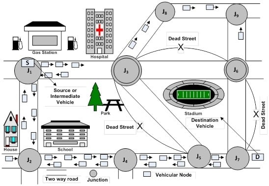
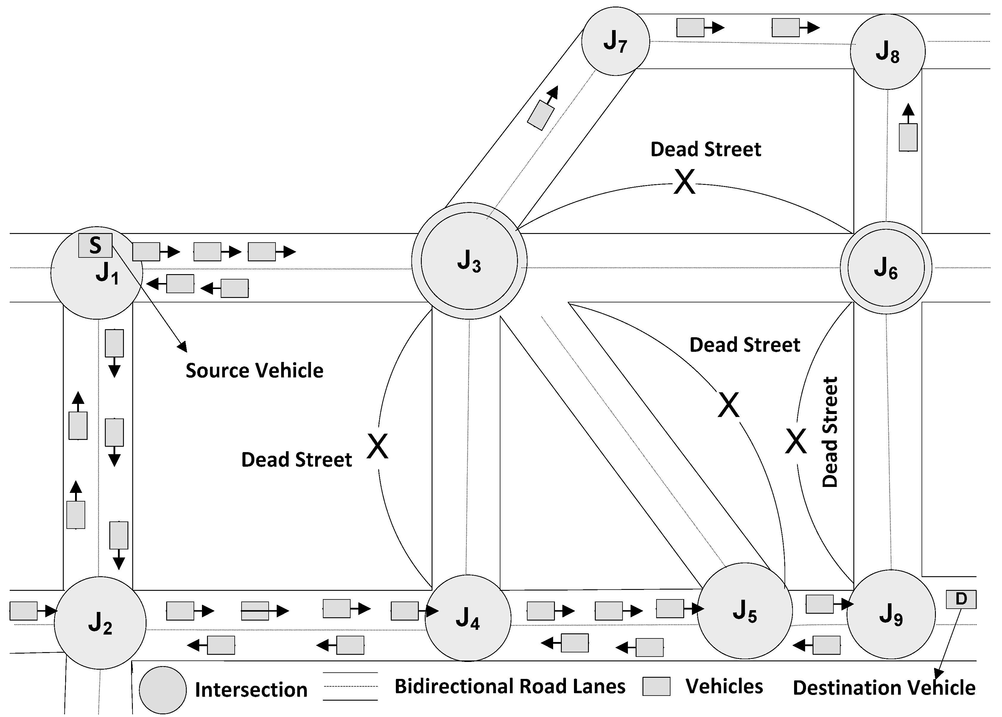
3.2.3. Illustrative Example for DMJSR Working

Consider the scenario of Figure 2 where the source vehicle S is at current junction J1 and is dispatching packet towards the destination D using DMJSR. In this case, there are 4 candidate two-hop neighbor junctions of current junction J1 available through which packet can be routed toward the destination. These include J4, J5, J6 and J8.
Our proposed algorithm will assign weights to each of two-hop neighbor junctions of J1 according to the traffic density and shortest curve metric distance to the destination. City streets that are connecting J1 to J4 have higher traffic density than J1–J5, J1–J8 and J1–J6. Consequently, J1 and J4 have higher connectivity than J1–J6, J1–J8 and J1–J5.Therefore, DMJSR will assign more weight to J4 as compared to J5, J6 and J8 and it will be chosen as next destination junction. In this way, our routing approach will remove the limitations of GyTAR, E-GyTAR, and TFOR. In the case of such routing protocols, J3 would have been selected instead of J4, which will not be considered because all these protocols based on the selection of one-hop junction, which results in a sub-optimal choice in this case. The packet would have been stuck in local maximum because after selecting J3, junctions J5 and J6 have no traffic density as these are along dead streets (those streets that contain no vehicle for carrying packet towards the destination). Our routing protocol route the packet from current junction J1 to J4 through J2 and in this way it will relay the packet towards the destination node. Therefore, in DMJSR, a packet will travel successively closer towards the destination node along the urban streets where there are adequate vehicular nodes to provide connectivity. It is worth mentioning that Figure 2 is just an illustration of one of the possible cases where the considered protocols would suffer in terms of performance and the proposed protocol will work well. The proposed protocol works well for all the considered simulation scenarios as discussed in Section 4.

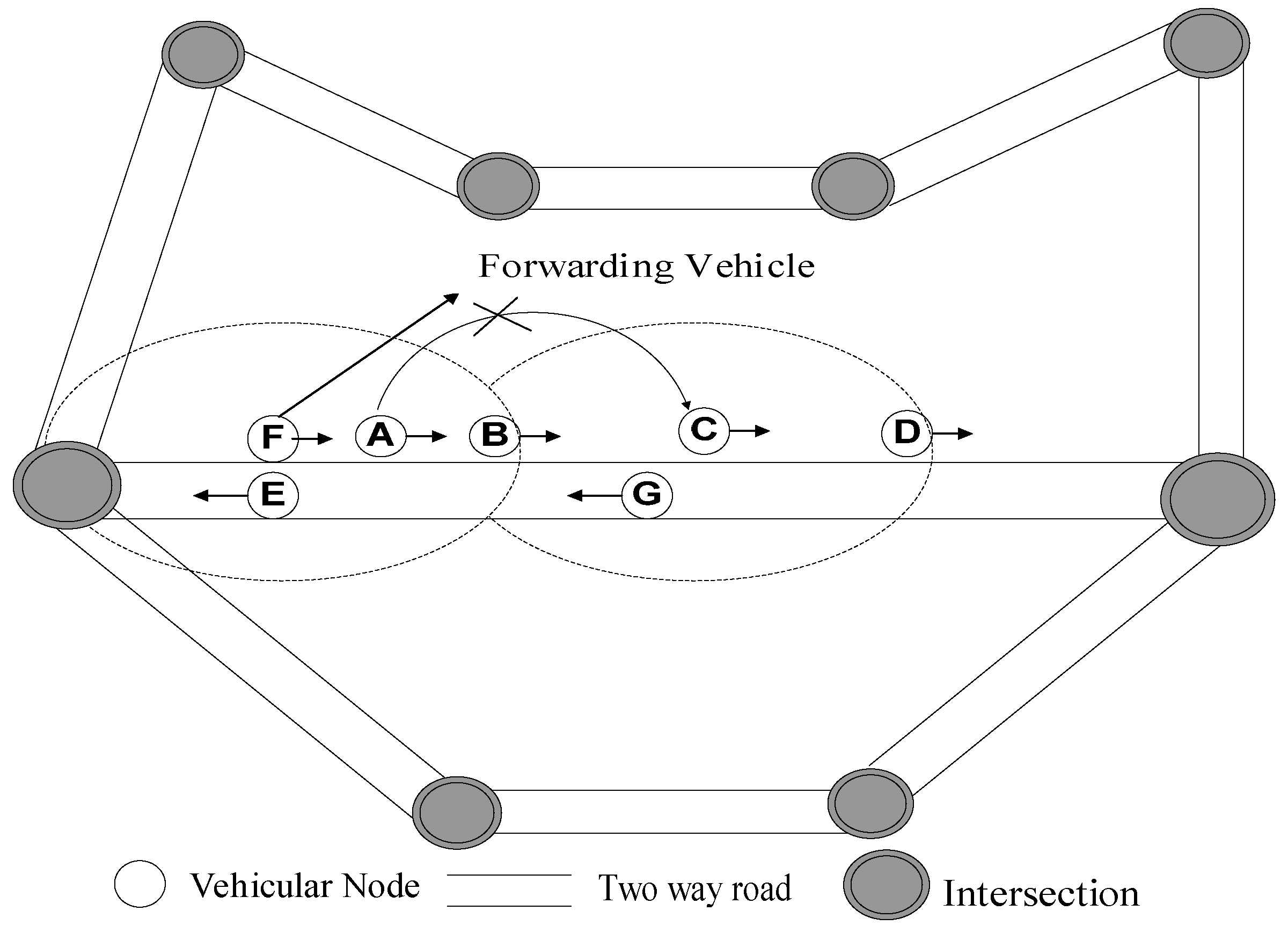
3.2.4. Forwarding between Junctions

After the determination of destination junction, DMJSR uses a greedy approach with one-hop neighbor information for moving forward data packets between junctions. It is achieved by marking all data packets with the location of the next destination junctions. Every vehicular node maintains a neighbor table that contains the direction, speed and position of each neighbor vehicular node. Neighbor table is updated through periodic beacon messages exchange. The packet carrier vehicular node consults its neighbor table for the most recent predicted locations of neighboring vehicles prior to forwarding the data packet. It forwards the packet to a one-hop neighbor that is closest to the destination.
Protocols like GyTAR [31] and E-GyTAR [2] make use of one-hop neighbor information based predictive strategy. This strategy prefers to forward the packet to the next node based on the speed of the vehicular node instead of preferring a node that lies closest to the destination. The one-hop neighbor having the highest speed is selected as next forwarding node. However, this approach has a few limitations. Firstly, in the presence of appropriate one-hop neighbors, it may end up selecting an inappropriate one-hop neighbor for forwarding packets which may incur more delay and hop count. For instance, Figure 3 presents a scenario mentioned in TFOR [3].
In this Scenario, suppose the neighbor A of F (forwarding vehicle) has greater speed among all of its one-hop neighbors such as B and E. The forwarding vehicular node F chooses vehicle A instead of vehicular node B because of its greater speed as compared to other neighbors and forward packet to it at time t1. Vehicular node A is unable to forward packet to vehicular node C at time t2, because vehicular node C is outside the transmission range of vehicular node A. But if the forwarding vehicular node F makes use of two-hop neighbor information which is accomplished by beacons exchange, then at time t2, F will be able to dispatch the packet to vehicular node C through neighbor vehicular node B instead of vehicular node A. This is because B is nearer to C and C is the closest vehicular node to destination vehicle D. By doing so, it minimizes the delay while reducing the number of intermediate hops while relaying the packet from source to destination.
Secondly, speed-based forwarding strategy can cause an increase in a number of hops due to the variable high speed of different nodes [3]. By considering these facts, TFOR proposed two-hop neighbor based greedy forwarding that prefers position and direction of two-hop neighbor nodes instead of speed.
Two-hop neighbor based forwarding strategy used in TFOR minimizes the hop count and diminishes the end-to-end delay as compared to one-hop speed based improved greedy forwarding of GyTAR [31]. Our proposed protocol DMJSR employs one-hop neighbor information based greedy forwarding technique in which forwarding node considers position and direction of one-hop neighbor as a substitute of two-hop neighbor based greedy forwarding of TFOR and one-hop speed based improved greedy forwarding of GyTAR and E-GyTAR which helps it to achieve improved performance as compared to existing strategies.
The reason for this selection is because first of all it is simpler as compared to other variants and secondly it generates less routing overhead in the highly dense environment as compared to maintaining two-hop neighbor information.
Despite the forwarding strategy based on one-hop neighbor information, the risk remains that a packet carrier vehicle is unable to locate a next candidate forwarding vehicle to forward the packet, in that case, it will make use of carry and forward approach [31]. The packet carrier vehicle will hold the packet until an appropriate forwarding node in its vicinity is found. However, our approach minimizes the use of carry and forward as compared to existing approaches because of its emphasis on connectivity during junction selection which reduces end-to-end delay and packet loss. As frequent use of carry and forward causes more delays due to lack of connectivity and also packet loss because of expiry of the time-to-live duration of the packet. In general, if our protocol during junction selection phase finds that there is no vehicular density around the next candidate junctions, it will simply employ carry and forward technique to move packet toward next destination junction.

4. Simulation Setup and Result Analysis

For performance evaluation, GloMoSim (Global Mobile System Simulator) (2.03, UCLA (University of California Los Angeles), Los Angeles, CA, USA, 2008) [3,35,42] is used to carry out simulations.

4.1. Mobility Model

It is a very vital step to choose an appropriate mobility model for VANETs simulation. The mobility model must exhibit the real vehicular characteristics. The mobility model also affects the performance of protocols [2,3]. The mobility models for vehicular environment usually have two categories. These are macroscopic and microscopic mobility models. The macroscopic mobility is actually a reflection of mobility constraints such as roads, number of road lanes, the city streets, speed limits, traffic lights, traffic density, and traffic flows. The microscopic mobility exhibits the characteristics such as vehicles conduct with each other and with the infrastructure [35,43]. Both micro and macro mobility categories are made available by the VanetMobiSim. It is an extended version of CANU (Communication in Ad-hoc Networks for Ubiquitous Computing) mobility simulation model [35,42,43].

4.2. Simulation Scenario

In our simulation, VanetMobiSim (1.1, Institut Eurecom, Sophia Antipolis, Valbonne, France, 2007) [43] is used to generate the vehicular mobility traces in an area of 3000 × 2700 m2. This area contains 18 intersections and 30 bidirectional multilane roads in which vehicular nodes mobility is simulated. At the start of the simulation, the vehicular nodes are randomly distributed over the multilane roads and move in both directions. The movements of the vehicles on the roads are based on car following model or intelligent driving model [43]. The vehicles speed depends on the kind of the vehicles (like car, bus, truck, etc.) and nature of the roads. The number of vehicles is varied from 100 to 350. The simulation results are averaged over 10 runs. The rest of the parameters are summarized in Table 2.

4.3. Simulation Results and Discussion

For performance comparison, we have compared three other routing protocols with our proposed protocol. These protocols are GSR [38], E-GyTAR [2] and TFOR [3]. The performance metrics used for comparison include packet delivery ratio, end-to-end delay, and routing overhead. Packet delivery ratio is defined as the percentage of packets that are successfully delivered to their destination vehicles. End-to-end delay is defined as the average delay incurred by the packet from its source to its destination. Routing overhead is the ratio of total control packets produced to the total data packets received at the destinations during the complete simulation [2,3,31].

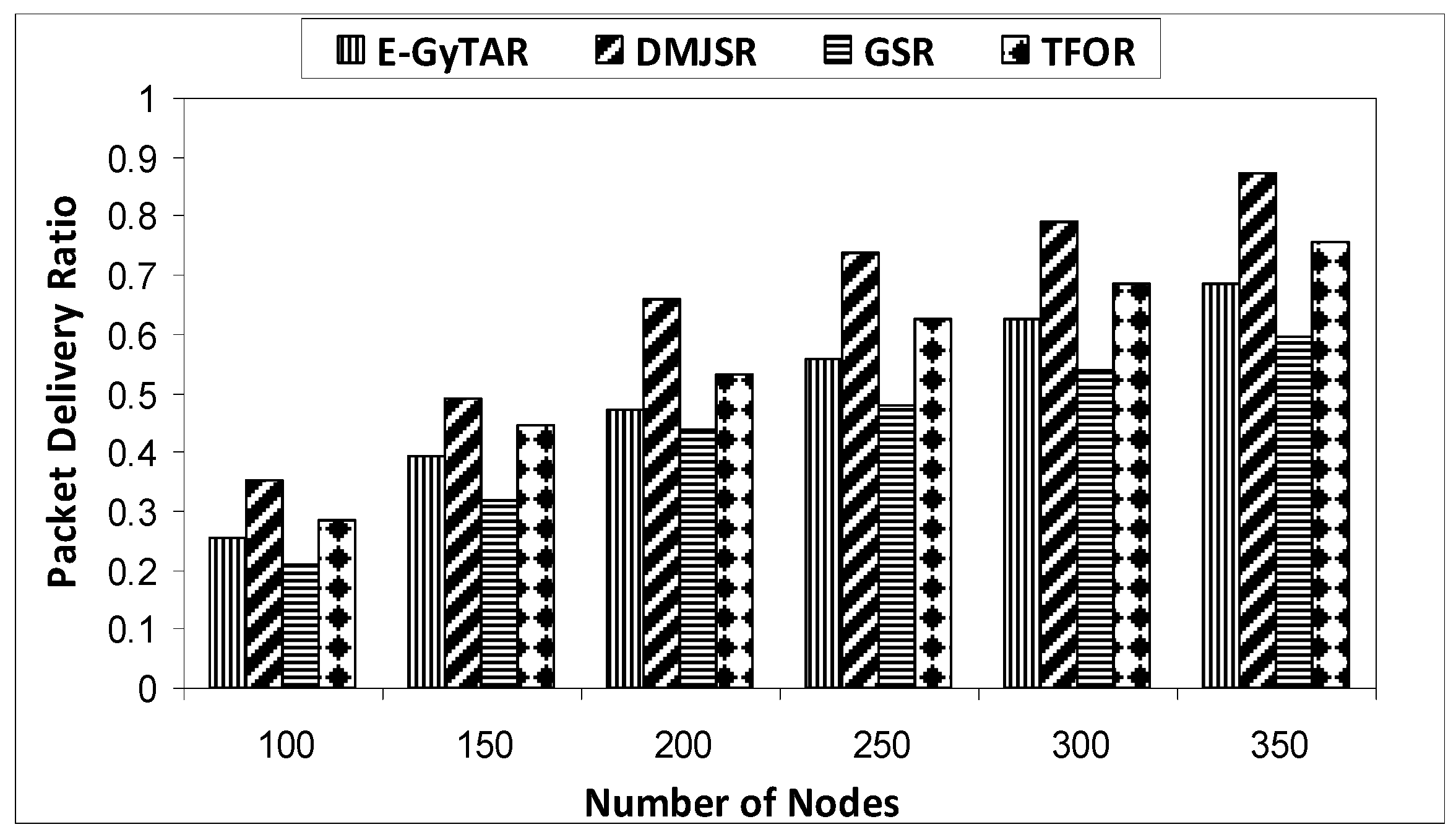
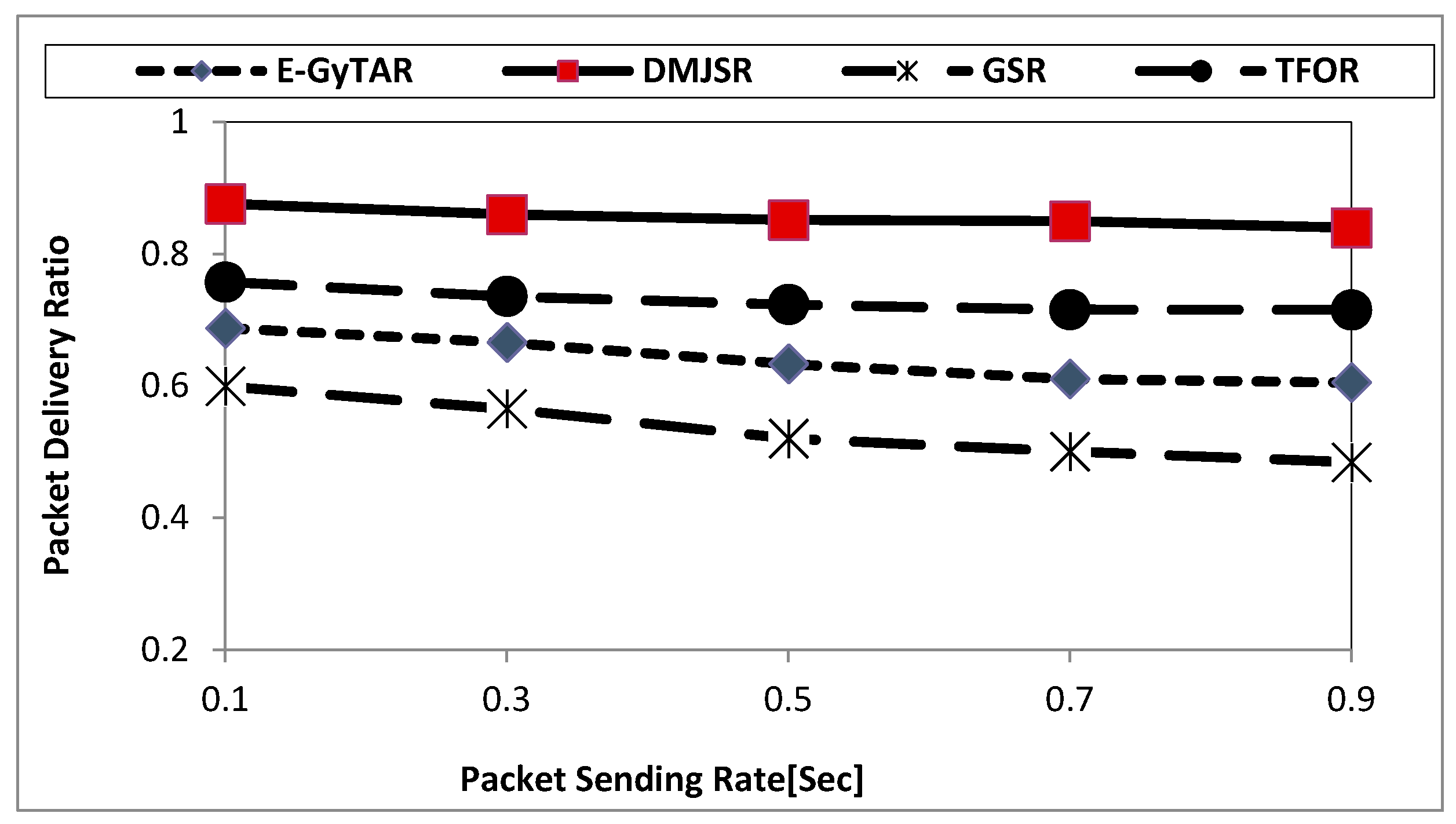
4.3.1. Packet Delivery Ratio

Figure 4 depicts that packet delivery ratio for all the considered protocols increases with increase in vehicular density. It can be observed from the figure that packet delivery ratio of DMJSR is higher as compared to GSR, E-GyTAR and TFOR. This is primarily because, in DMJSR, the routing path is established progressively based on multiple junctions ensuring that the junctions with higher vehicular traffic density are selected. Consequently, a packet will travel successively closer towards the destination along the city streets where there are adequate vehicular nodes to ensure high network connectivity. Whereas in case of GSR, the source vehicle computes series of junction statically before transmission of the packet without taking into account the vehicular traffic density. As a result, some data packets are unable to find their destination node because of lack of connectivity on some segments of city streets. However, the problem with E-GyTAR and TFOR is that they establish path based on one junction at a time. As a result, sometimes those junctions whose next streets contain no vehicular traffic are selected. Selection of such streets results in local optimum and as a result, packet delivery ratio decreases. The new dynamic multiple junction selection mechanism and one-hop position and direction based forwarding mechanism minimize the occurrence of such cases and this helps DMJSR to bring considerable improvement in terms of packet delivery ratio as compared to GSR, E-GyTAR and TFOR.
Figure 5 shows a comparison of packet delivery ratio vs. packet sending rates. Increasing packet-sending rate to certain values for all protocols decreases packet delivery ratio. It brings congestion which compels the network to drop some packets. In GSR, certain nodes on the preselected paths instigate more packet transmission which results in more decrease in packet delivery ratio as compared to others routing protocols. The packet-sending rate does not spoil too much the performance of E-GyTAR, TFOR and DMJSR in terms of delivery ratio.

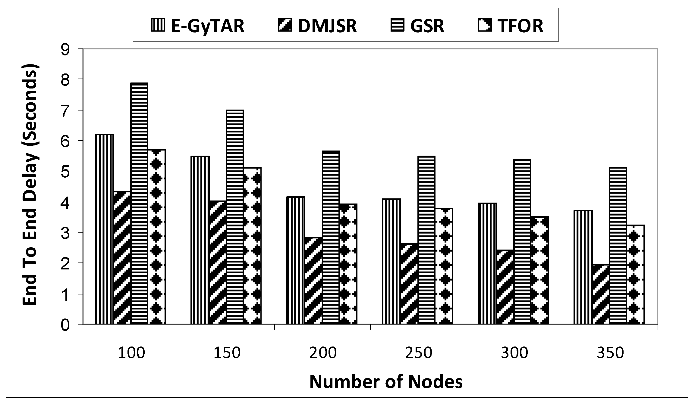
4.3.2. End-To-End Delay

Figure 6 illustrates that DMJSR outperforms GSR, E-GyTAR and TFOR in terms of end-to-end delay as well. This is because DMJSR avoids pre-determining an end-to-end routing path before dispatching data packets without considering connectivity as GSR does: the route in DMJSR is discovered progressively based on multiple junction mechanism by considering network connectivity when relaying data packets from source to destination. In E-GyTAR only directional density is used to find the path, but in urban scenarios with a two-lane road, there are a lot of streets having non-directional density and shortest distance to the destination that can play a key role for relaying packets towards the destination during routing. The speed based greedy forwarding approach of E-GyTAR results in incurring more hops while relaying the packet from source to destination resulting in an increase in end-to-end delay. In DMJSR, there is a reduction in the number of hops required to deliver data packets due to use of the forwarding mechanism that maintains one-hop neighbor information based on position and direction instead of the speed of vehicular node to forward packets between two junctions. Although, TFOR uses directional and non-directional traffic density to accomplish routing path but still suffer from the local optimum problem at junction level which causes more delay. DMJSR selects those multiple junctions that provide enough connectivity as compared to E-GyTAR and TFOR and is less likely to be affected by local optimum. For GSR, E-GyTAR and TFOR, the likelihood of packets staying more time in suspension buffer of a vehicular node is more as compared to DMJSR, which results in an increase in end-to-end delay for GSR, E-GyTAR and TFOR. The novel combination of multiple junction selection mechanism with position and direction based one-hop forwarding mechanism in DMJSR leads to a considerable reduction of end-to-end delay in comparison to the other protocols.

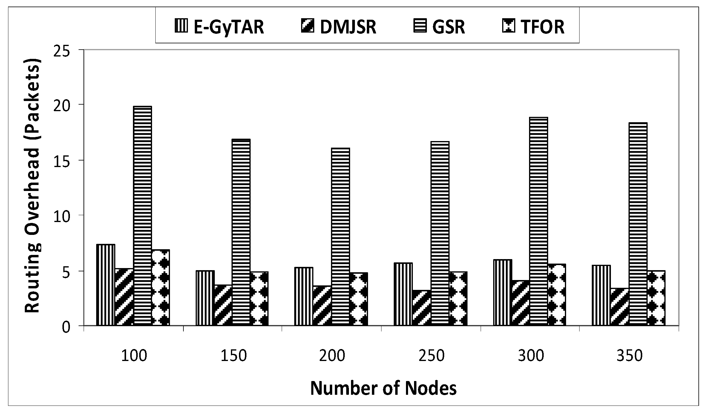
4.3.3. Routing Overhead

Figure 7 shows the routing-overhead of all the three protocols against the number of the nodes. With an increase in vehicular density, there is an increase in routing overhead for all the protocols. This is because the amount of control messages depends on the number of vehicles. DMJSR has least routing overhead as compared to GSR, E-GyTAR and TFOR. GSR incurs higher routing overhead because of generation of more beacon messages. It obtains the locations of its neighbor by generating a higher amount of beacons messages as compared to other routing protocols. While in E-GyTAR the routing overhead increases because of its improper junction selection mechanism that causes local optimum in the absence of directional density of vehicles. TFOR also produces more overhead because of its junction selection mechanism. Additionally, maintaining two-hop neighbor information in greedy forwarding brings more routing overhead for TFOR in highly dense environments like traffic jams.

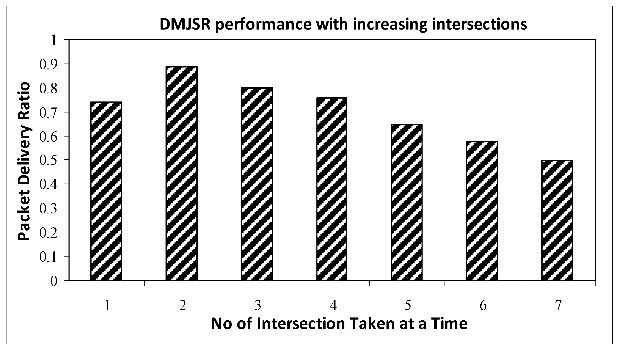
4.3.4. Impact of Increasing Number of Considered Junctions Dynamically

One important question that needs to be answered is that what is the optimal number of junctions that should be considered for achieving the best performance in terms of various parameters? For answering this question, we have compared the performance in terms of packet delivery ratio with respect to increasing the number of considered junctions. The simulation result shows that considering two junctions results in a better performance as compared to considering more than two junctions.
Figure 8 shows that increasing the number of considered junctions from 1 to 2 results in an increase in packet delivery ratio. However, as we start increasing the number of junctions beyond 2, the performance of DMJSR starts to degrade in terms of packet delivery ratio. The major reason behind this observation lies in one of the very basic characteristics of VANETs, i.e., the network in VANETs is very dynamic and the network topology changes very rapidly. Because of this reason, considering more than 2 junctions while making a decision for packet forwarding degrades the performance instead of achieving an enhanced performance. Moreover, keeping all the information that lies between multiple junction such as density, direction of vehicles etc., in a very dynamic topology also leads to an overhead in terms of processing and storage. The simulation results revealed that the proposed protocol is capable of achieving better performance as compared to existing routing protocols. As a next step, performance evaluation using a more complex mobility model based on real traffic traces that fully capture the complexity involved in the movement of the nodes can be considered.

5. Conclusions

In this paper, a novel multiple junction selection based routing protocol (DMJSR) is proposed. We first presented the major problems faced by some of the already well-known protocols in VANETs. Then we explained our new proposed protocol and explained how it overcomes the limitations faced by existing protocols. DMJSR selects two junctions at a time based on traffic density and shortest curve metric distance to the destination. DMJSR employs a novel multiple junction approach, an improved greedy forwarding strategy based on one-hop neighbor information to relay packets in between junctions, and a recovery strategy, which can incorporate urban surroundings challenges in a better way. The simulation results indicated that our proposed protocol convincingly outperforms TFOR, E-GyTAR, and GSR in terms of packet delivery ratio end-to-end delay because of its ability to incorporate in better ways the main challenges faced in the city environments as compared to the existing routing protocols.

Acknowledgments

This work is fully funded by the Research and Innovation Management Center University of Malaysia Sarawak (RIMC-UNIMAS) under the grant number F08/SpSG/1403/16/4.

Author Contributions

Irshad Abbasi is the main author of this manuscript. All the authors have contributed to this manuscript. All authors have read and approved the final manuscript. Irshad Abbasi conceived the novel idea and designed the experiments; Irshad Abbasi performed the experiments; Irshad Abbasi analyzed the data; Irshad Abbasi contributed materials/analysis tools; Irshad Abbasi wrote the entire paper. Irshad Abbasi, Adnan Shahid Khan and Shahzad Ali checked, reviewed and revised the paper. Irshad Abbasi accomplished final proofreading. Adnan Shahid Khan supervised the research.

Conflicts of Interest

The authors declare no conflict of interest.

References

  1. Abdalla, G.M.T.; Rgheff, M.A.A.; Senouci, S.M. Current trends in vehicular ad hoc networks. Ubiquitous Comput. Commun. J. 2008, 11, 1–9. [Google Scholar]
  2. Bilal, S.M.; Madani, S.A.; Khan, I.A. Enhanced junction selection mechanism for routing protocol in VANETs. Int. Arab J. Inf. Technol. 2011, 8, 422–429. [Google Scholar]
  3. Abbasi, I.A.; Nazir, B.; Bilal, S.M.; Madani, S.A. A traffic flow oriented routing protocol for VANET. EURASIP J. Wirel. Commun. Netw. 2014, 2014, 121. [Google Scholar] [CrossRef]
  4. Sharma, R.; Choudhry, A. An extensive survey on different routing protocols and issue in VANETs. Int. J. Comput. Appl. 2014, 106, 1–18. [Google Scholar]
  5. Shah, S.A.A.; Shiraz, M.; Nasir, M.K.; Noor, R.B.M. Unicast routing protocols for urban vehicular networks: Review, taxonomy, and research issues. J. Zhejiang Univ. Sci. (Comput. Electron.) 2014, 15, 489–513. [Google Scholar] [CrossRef]
  6. Silva, A.C. Applicability of position-based routing for VANET in highways and urban Environment. Port. J. Netw. Comput. Appl. 2013, 36, 961–973. [Google Scholar]
  7. Dhankhar, S.; Agrawal, S. A survey on routing protocols and issues. Int. J. Innov. Res. Sci. Eng. Technol. 2014, 3, 13427–13434. [Google Scholar]
  8. Husain, A.; Shringar, R.; Kumar, B.; Doegar, A. Performance comparison topology based and position based Routing protocols in vehicular network environments. Int. J. Wirel. Mob. Netw. (IJWMN) 2011, 3, 289–303. [Google Scholar] [CrossRef]
  9. Jimenez, F.; Clavijo, M.; Jose, E.N.; Gomez, O. Improving the Lane Reference Detection for Autonomous Road Vehicle Control. Sensors 2016, 13, 9497524. [Google Scholar] [CrossRef]
  10. Naranjo, J.E.; Jimenez, F.; Anaya, J.J.; Talavera, E.; Gomez, O. Application of vehicle to another entity (V2X) communications for motorcycle crash avoidance. J. Intell. Transp. Syst. 2017, 21, 285–295. [Google Scholar] [CrossRef]
  11. Abbasi, I.A.; Khan, A.S. A Review of Vehicle to Vehicle Communication Protocols for VANETs in the Urban Environment. J. Future Internet 2018, 10, 14. [Google Scholar] [CrossRef]
  12. Lin, Y.W.; Chen, Y.S.; Lee, S.L. Routing protocols in vehicular ad hoc networks: A survey and future perspectives. J. Inf. Sci. Eng. 2010, 26, 913–932. [Google Scholar]
  13. Gupta, N.; Prakash, A.; Tripathi, R. Adaptive Beaconing in mobility aware clustering based MAC protocol for safety message dissemination in VANET. Wirel. Commun. Mob. Comput. 2017, 2017, 1246172. [Google Scholar] [CrossRef]
  14. Bilal, S.M.; Khan, A.R.; Ali, S. Review and performance analysis of position based routing protocols. Wirel. Pers. Area Commun. 2017, 94, 559–578. [Google Scholar] [CrossRef]
  15. Car-Talk 2000. Available online: http://www.cartalk2000.net/ (accessed on 5 April 2017).
  16. CAR 2 CAR Communication Consortiums. Available online: http://www.car-to-car.org (accessed on 27 April 2017).
  17. California Partners for Advanced Transit and Highways. Available online: http://www.path.berkeley.edu (accessed on 3 January 2018).
  18. FleetNet. Available online: https://fleetnetamerica.com (accessed on 11 June 2017).
  19. Crash Avoidance Metrics Partnership. Available online: https://www.mentor.com (accessed on 29 August 2017).
  20. Chauffeur in EU. Available online: http://www.autoeurope.com/go/chauffeur-services (accessed on 3 January 2018).
  21. Karp, B.; Kung, H.T. Greedy perimeter stateless routing for wireless networks. In Proceedings of the 6th Annual International Conference on Mobile Computing and Networking (ICMCN ’6), Boston, MA, USA, 6–11 August 2000; ACM: New York, NY, USA, 2000; pp. 243–254. [Google Scholar]
  22. Rahim, A.; Ahmad, I.; Khan, Z.S.; Sher, M.; Javed, A.; Shoaib, M.; Mahmood, R. A Comparative study of mobile and vehicular adhoc networks. Int. J. Recent Trends Eng. 2009, 2, 195–197. [Google Scholar]
  23. Hartenstein, H.; Laberteaux, K.P. Vehicular Applications and Internetworking Technologies; Wiley Online Library: Hoboken, NJ, USA, 2010; pp. 1–14. [Google Scholar]
  24. Jaap, S.; Bechler, M. Evaluation of routing protocols for vehicular ad hoc networks in city traffic scenarios. In Proceedings of the 5th International Conference on Intelligent Transportation Systems Telecommunications (ITST ’5), Brest, France, 27–29 June 2005; pp. 1–9. [Google Scholar]
  25. Cheng, J.; Cheng, J.; Zhou, M.C.; Liu, F.Q.; Gao, S.C.; Liu, C. Routing in Internet of vehicles: A Review. IEEE Trans. Intell. Transp. Syst. 2015, 16, 2339–2352. [Google Scholar] [CrossRef]
  26. Sharef, B.T.; Alsaqour, R.A.; Ismail, M. Review: Vehicular communication ad hoc routing protocols: A survey. J. Netw. Comput. Appl. 2014, 40, 363–396. [Google Scholar] [CrossRef]
  27. Lee, K.C.; Lee, U.; Gerla, M. Advances in Vehicular Ad-Hoc Networks: Developments and Challenges; Chapter Survey of Routing Protocols in Vehicular Ad Hoc Networks; IGI Global: Harrisburg, PA, USA, 2009. [Google Scholar]
  28. Li, F.; Wang, Y. Routing in vehicular ad hoc networks: A survey. IEEE Veh. Technol. Mag. 2007, 15, 12–22. [Google Scholar] [CrossRef]
  29. Johnson, D.B.; Maltz, D.A. Dynamic Source Routing in Ad Hoc Wireless Networks; Kluwer Academic Publishers: Norwell, MA, USA, 1996; pp. 153–181. [Google Scholar]
  30. Perkins, C.E.; Royer, E.M. Ad hoc on demand distance vector routing. In Proceedings of the Second IEEE Workshop on Wireless Mobile Computing Systems and Applications (WMCSA ’2), New Orleans, LA, USA, 25–26 February 1999; pp. 90–100. [Google Scholar]
  31. Jerbi, M.; Senouci, S.M.; Meraihi, R.; Doudane, Y.G. An improved vehicular ad hoc routing protocol for city Environments. In Proceedings of the IEEE International Conference on Communications (ICC ’07), Glasgow, UK, 24–28 June 2007; pp. 1–8. [Google Scholar]
  32. Clausen:, T.; Jacquet, P. Optimized Link State Routing Protocol; RFC 3626; Internet Engineering Task Force: Fremont, CA, USA, 2003. [Google Scholar]
  33. Lochert, C.; Mauve, M.; Fubler, H.; Hartenstein, H. Geographic routing in city scenarios. SIGMOBILE Mob. Comput. Commun. Rev. 2005, 5, 69–72. [Google Scholar] [CrossRef]
  34. Kieb, W.; Fubler, H.; Widmer, J.; Mauve, M. Hierarchical location service for mobile ad hoc networks. SIGMOBILE Mobile Comput. Commun. Rev. 2004, 8, 47–58. [Google Scholar]
  35. Politecnico, M.F.; Abruzzi, C.D.D.; Harri, J.; Filali, F. Vehicular Mobility Simulation for VANETs; Christian Bonnet Institute Eurecom, Department of Mobile Communications 06904: Sophia, France, 2011; pp. 1–14. [Google Scholar]
  36. Li, J.; Jannotti, J.; Decouto, D.S.J.; Karger, D.R.; Morris, R. A scalable location service for geographic ad hoc routing. In Proceedings of the 6th Annual International Conference on Mobile Computing and Networking (MobiCom ’6), Boston, MA, USA, 6–11 August 2000; ACM: New York, NY, USA, 2000; pp. 120–130. [Google Scholar]
  37. Kasemann, M.; Fubler, H.; Hartenstein, H.; Mauve, M. A Reactive Location Service for Mobile Ad Hoc Networks; Technical Report TR-02-014; Department of Computer Science, University of Mannheim: Mannheim, Germany, 2002. [Google Scholar]
  38. Lochert, C.; Hartenstein, H.; Tian, J.; Fubler, H.; Hermann, D.; Mauve, M. A routing strategy for vehicular ad hoc network in city environment. In Proceedings of the IEEE Intelligent Vehicles Symposium (IVS), Columbus, OH, USA, 9–11 June 2003; pp. 156–161. [Google Scholar]
  39. Lee, K.C.; Haerri, J.; Lee, U. Enhanced perimeter routing for geographic forwarding protocols in urban vehicular scenarios. In Proceedings of the IEEE Globecom Workshops, Washington, DC, USA, 26–30 November 2007; pp. 1–9. [Google Scholar]
  40. Seet, B.C.; Liu, G.; Lee, B.S.; Foh, C.H.; Wong, K.J.; Lee, K.K. A-STAR: A mobile ad hoc routing strategy for metropolitan area in vehicular communications. In NETWORKIN2004, Networking Technologies, Services, and Protocols; Performance of Computer and Communication Networks, Mobile and Wireless Communications; Lecture Notes in Computer Science; Springer: Berlin/Heidelberg, Germany, 2004; pp. 989–999. [Google Scholar]
  41. Jerbi, M.; Senouci, S.M.; Rasheed, T.; Ghamri, Y. An infrastructure free intervehicular communication based traffic information. In Proceedings of the First IEEE International Symposium on Wireless Vehicular Communication (WiVec ’07), Baltimore, MD, USA, 30 September–1 October 2007. [Google Scholar]
  42. GLOMOSIM Simulator. Available online: https://networksimulationtools.com/glomosim-simulator-projects (accessed on 15 March 2017).
  43. Harri, J.; Filali, F.; Bonnet, C.; Fiore, M. VanetMobiSim: Generating realistic mobility patterns for VANETs. In Proceedings of the 3rd ACM International Workshop on Vehicular Ad Hoc Networks (ACM Wkshps ’06), Los Angeles, CA, USA, 24–29 September 2006; pp. 86–97. [Google Scholar]
Figure 1. Limitations of Greedy Traffic Aware Routing Protocol (GyTAR), Enhanced Greedy Traffic Aware Routing Protocol (E-GyTAR), and Traffic Flow Oriented Routing Protocol (TFOR).
Applsci 08 00687 g001
Figure 2. Working of Dynamic Multiple Junction Selection based Routing Protocol (DMJSR).
Applsci 08 00687 g002
Figure 3. Limitation of speed based improved greedy forwarding strategy used in GyTAR, and E-GyTAR.
Applsci 08 00687 g003
Figure 4. Packet delivery ratio vs. the number of nodes (@5 packets/second). GSR, Geographic Source Routing Protocol; DMJSR, Dynamic Multiple Junction Selection based Routing Protocol; TFOR, Traffic Flow Oriented Routing Protocol; E-GyTAR, Enhanced Greedy Traffic Aware Routing Protocol.
Applsci 08 00687 g004
Figure 5. Delivery ratio as a function of the packet-sending rate (350 nodes).
Applsci 08 00687 g005
Figure 6. End-to-end delay vs. the number of nodes (@5 packets/second).
Applsci 08 00687 g006
Figure 7. Routing overhead vs. the number of nodes (@5 packets/second).
Applsci 08 00687 g007
Figure 8. Packet delivery ratio vs. increasing no of junctions dynamically at a time @ 350 vehicular nodes.
Applsci 08 00687 g008
Table 1. The comparative analysis of position-based routing protocols.
CharateristicsLocation Based Routing Protocols for VANETs
GSR [34]GPCR [33]GPSRJ+ [39]A-STAR [40]GyTAR [31]E-GyTAR [2]TFOR [3]DGSR [14]E-GyTARD [14]
Dynamic Junction SelectionNoNoNoNoYesYesYesYesYes
Static Junction SelectionYes-NoYesNoNoNoNoNo
ScenarioCityCityCityCityCityCityCityCityCity
Hop CountSingle hopSingle hopTwo hopsSingle hopSingle hopSingle hopTwo hopsSingle hopSingle hop
Realistic Mobility FlowsYesYesYesYesYesYesYesYesYes
Local Optimum Handling StrategyFall back on greedy modeRight hand rulePerimeter modeReconstruct anchor pathCarry and forwardCarry and forwardCarry and forwardCarry and forwardCarry and forward
Map RequiredYesYesYesYesYesYesYesYesYes
GPS RequiredYesYesYesYesYesYesYesYesYes
Prediction BasedNoNoYesNoYesYesYesNoYes
Location Service RequiredYesYesYesYesYesYesYesYesYes
Traffic AwareNoNoNoNoYesYesYesNoYes
1 VANETs, Vehicular Ad-hoc Networks; GSR, Geographic Source Routing Protocol; GPCR, Greedy Perimeter Coordinator Routing Protocol; GPSRJ+, Greedy Perimeter Stateless Routing Junction+ Protocol; A-STAR, Anchor-based Street and Traffic Aware Routing Protocol; E-GyTAR, Enhanced Greedy Traffic Aware Routing Protocol; TFOR, Traffic Flow Oriented Routing Protocol; DGSR, Directional Greedy Source Routing Protocol; E-GyTARD, Enhanced Greedy Traffic Aware Routing Protocol-Directional.
Table 2. Simulation setup.
Simulation/ScenarioMAC/Routing
Simulation time250 minMAC (Medium Access Control) protocol802.11 DCF (Distributed Coordination Function)
Map size3000 × 2700 m2Channel capacity54 Mbps
Mobility modelVanetMobiSimTransmission range266 m
Number of intersections23Traffic model15 CBR connections
Number of double lane roads36Packet sending rate(1–10 packet(s)/second)
Number of vehicles100–350Vehicle Speed35–60 Km/h
Number of simulation runs10Packet size128 bytes
Weighting factorsα = 0.5, β = 0.5, H1 = 0.5, H2 = 0.5Beacon Interval1 s

