
Multi-Sensor Approach Combined with Pedological Investigations to Understand Site-Specific Variability of Soil Properties and Potentially Toxic Elements (PTEs) Content of an Industrial Contaminated Area

 ,
,  , , ,
, , ,
Abstract
:Featured Application
Abstract
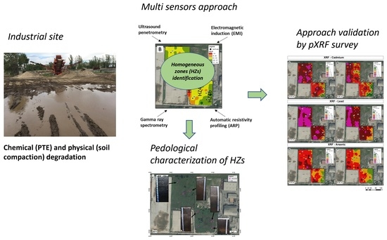
1. Introduction
2. Materials and Methods
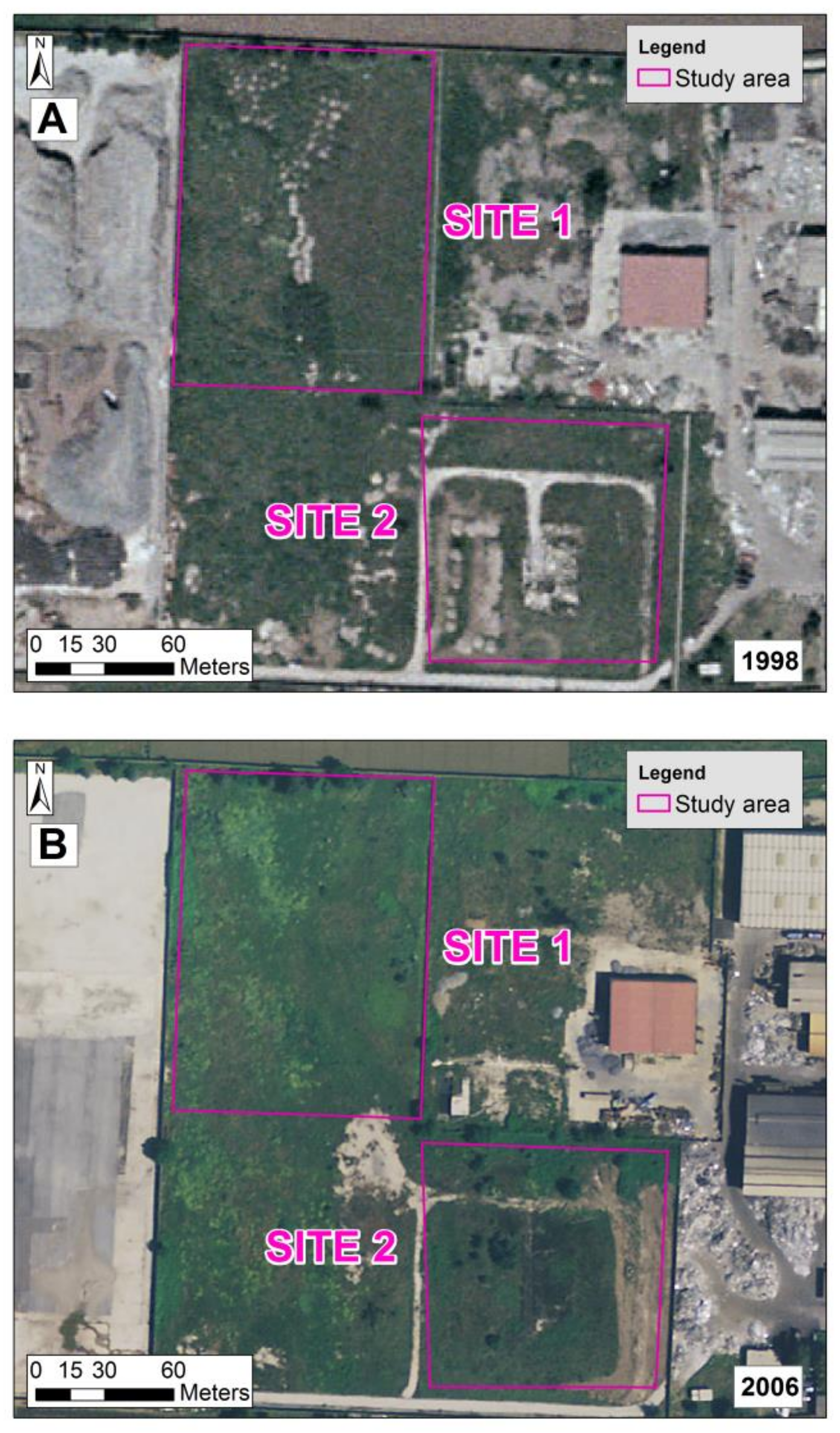
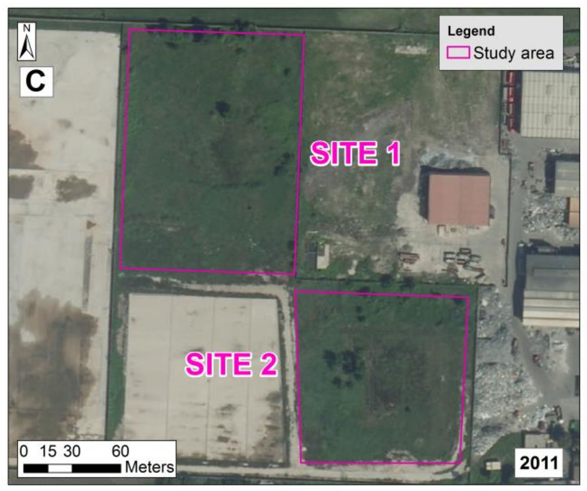
2.1. Geographical Setting
2.2. Geophysical Sensors
2.3. Gamma Ray and Penetrometry Surveys
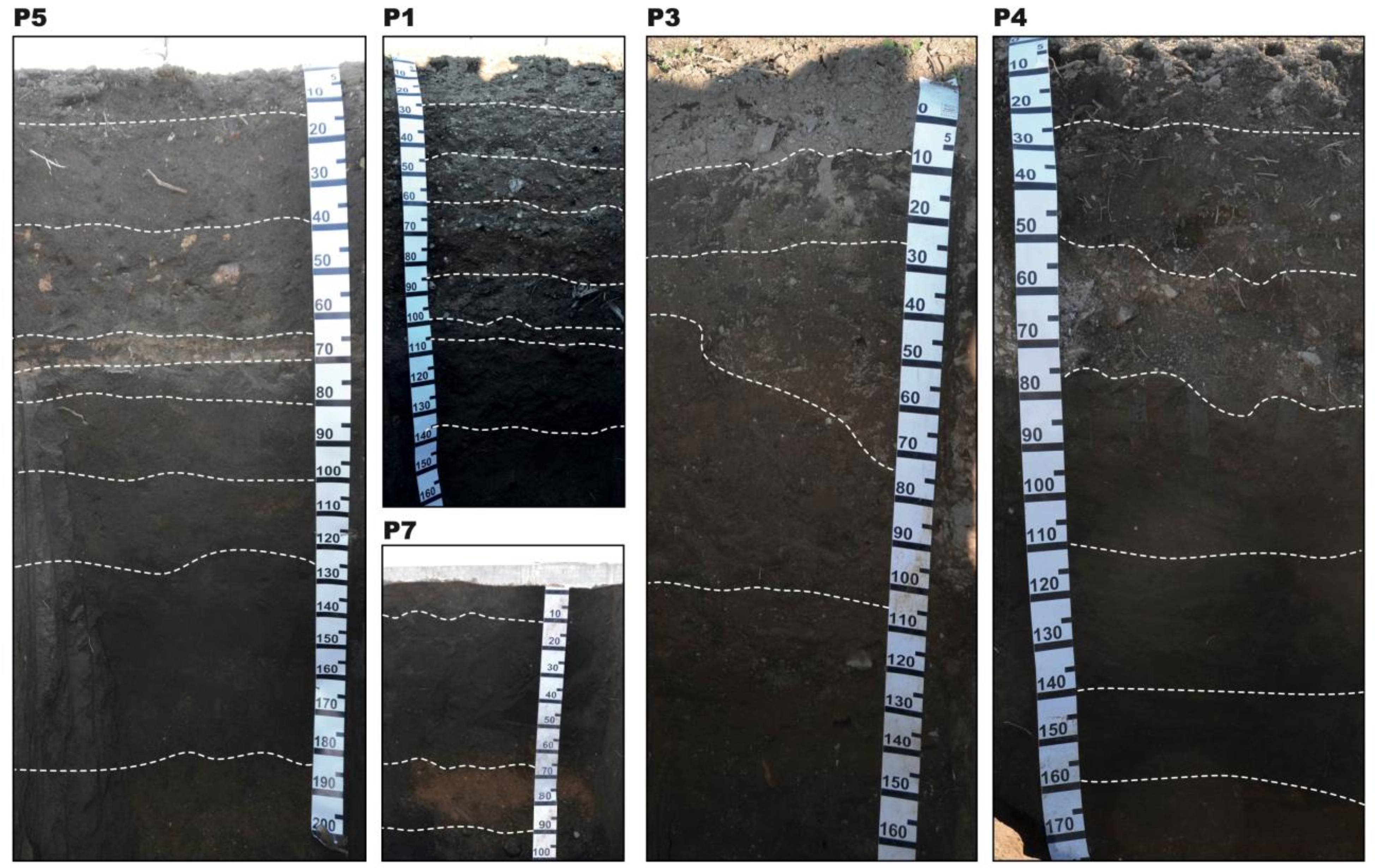
2.4. Pedological Survey
2.5. PXRF Measurements
3. Results and Discussion
3.1. Spatial Distribution of Parameters Obtained by Geophysical Sensors
3.2. γ-rays Spectrometry and Penetrometry Surveys
3.3. Pedological and Chemical Properties of the Homogeneous Zones (HZs)
3.4. PXRF (Portable X-ray Fluorescence): Spatial Survey
4. Conclusions
Supplementary Materials
Author Contributions
Funding
Conflicts of Interest
References
- Oldeman, L.R.; Hakkeling, R.T.A.; Sombroek, W.G. World Map of the Status of Human-Induced Soil Degradation: An Explanatory Note; Global Assessment of Soil Degradation (GLASOD): Wageningen, The Netherlands, 1991. [Google Scholar]
- DECA. Assessment Levels for Soil, Sediment and Water; DECA: Reston, VA, USA, 2010. [Google Scholar]
- CCICED. Special Policy Study on Soil Pollution Management; CCICED: Ottawa, ON, Canada, 2015. [Google Scholar]
- US EPA. Protecting and Restoring Land: Making a Visible Difference in Communities: OSWER FY13 End of Year Accomplishments Report; US EPA: Washington, DC, USA, 2013. [Google Scholar]
- Van Liedekerke, M.; Prokop, G.; Rabl-Berger, S.; Kibblewhite, M.; Louwagie, G. Progress in the Management of Contaminated Sites in Europe; Joint Research Centre of European Comission: Brussels, Belgium, 2014; ISBN 978-9-27934-846-4. [Google Scholar]
- Demattê, J.A.M.; Sayão, V.M.; Rizzo, R.; Fongaro, C.T. Soil class and attribute dynamics and their relationship with natural vegetation based on satellite remote sensing. Geoderma 2017, 302, 39–51. [Google Scholar] [CrossRef]
- Global Assessment of Soil Pollution: Report; FAO: Rome, Italy, 2021.
- Panagiotakis, I.; Dermatas, D. Remediation of contaminated sites. Bull. Environ. Contam. Toxicol. 2015, 94, 267–268. [Google Scholar] [CrossRef] [PubMed]
- Wu, J.; Liu, M.C.; Chang, C. Algorithmic elaboration on multi-source image registration in remote sensing. In Proceedings of the International Archives of the Photogrammetry, Remote Sensing and Spatial Information Sciences; International Society for Photogrammetry and Remote Sensing, ISPRS, Beijing, China, 3–11 July 2008; pp. 893–898. [Google Scholar]
- Choe, E.; van der Meer, F.; van Ruitenbeek, F.; van der Werff, H.; de Smeth, B.; Kim, K.W. Mapping of heavy metal pollution in stream sediments using combined geochemistry, field spectroscopy, and hyperspectral remote sensing: A case study of the Rodalquilar mining area, SE Spain. Remote Sens. Environ. 2008, 112, 3222–3233. [Google Scholar] [CrossRef]
- Wu, Y.; Chen, J.; Ji, J.; Gong, P.; Liao, Q.; Tian, Q.; Ma, H. A Mechanism Study of Reflectance Spectroscopy for Investigating Heavy Metals in Soils. Soil Sci. Soc. Am. J. 2007, 71, 918–926. [Google Scholar] [CrossRef]
- Saghatelyan, A.; Sahakyan, L.; Asmaryan, S.; Amirkhanyan, M.; Muradyan, V. Remote Sensing in Eco-Geochemical Assessment of Heavy Metal Pollution of Territories. In Proceedings of the 5th EA-SDI International Conference. Environmental Accounting-Sustainable Development Indicators, Prague, Czech Republic, 23–24 April 2009; pp. 23–24. [Google Scholar]
- Asmaryan, S.G.; Muradyan, V.S.; Sahakyan, L.V.; Saghatelyan, A.K.; Warner, T. Development of remote sensing methods for assessing and mapping soil pollution with heavy metals. In Proceedings of the GlobalSoilMap: Basis of the Global Spatial Soil Information System Proceedings of the 1st GlobalSoilMap Conference, Orléans, France, 7–9 October 2013; CRC Press: Boca Raton, FL, USA, 2014. [Google Scholar]
- Zhang, D.; Zhou, G. Estimation of soil moisture from optical and thermal remote sensing: A review. Sensors 2016, 16, 1308. [Google Scholar] [CrossRef] [Green Version]
- Shabou, M.; Mougenot, B.; Chabaane, Z.L.; Walter, C.; Boulet, G.; Aissa, N.B.; Zribi, M. Soil clay content mapping using a time series of Landsat TM data in semi-arid lands. Remote Sens. 2015, 7, 6059–6078. [Google Scholar] [CrossRef] [Green Version]
- Latif, B.A.; Lecerf, R.; Mercier, G.; Hubert-Moy, L. Preprocessing of low-resolution time series contaminated by clouds and shadows. IEEE Trans. Geosci. Remote Sens. 2008, 46, 2083–2096. [Google Scholar] [CrossRef]
- ESA/ESRIN. Services and perspectives. In Proceedings of the 1st Sentinel-2 Preparatory Symposium, Frascati, Italy, 23–27 April 2012. [Google Scholar]
- Castrignanò, A.; Buttafuoco, G.; Quarto, R.; Parisi, D.; Rossel, R.A.V.; Terribile, F.; Langella, G.; Venezia, A. Catena A geostatistical sensor data fusion approach for delineating homogeneous management zones in Precision Agriculture. Catena 2018, 167, 293–304. [Google Scholar] [CrossRef]
- Castrignan, A.; Buttafuoco, G.; Quarto, R.; Vitti, C.; Langella, G.; Terribile, F.; Id, A.V. A Combined Approach of Sensor Data Fusion and Multivariate Geostatistics for Delineation of Homogeneous Zones in an Agricultural Field. Sensors 2017, 17, 2794. [Google Scholar] [CrossRef]
- Langella, G.; Agrillo, A.; Basile, A.; De Mascellis, R.; Manna, P.; Moretti, P.; Mileti, F.A.; Terribile, F.; Vingiani, S. Geography of soil contamination for characterization and precision remediation of potentially contaminated sites. Ital. J. Agron. 2018, 13, 6–15. [Google Scholar]
- Higueras, P.; Oyarzun, R.; Iraizoz, J.M.; Lorenzo, S.; Esbrí, J.M.; Martínez-Coronado, A. Low-cost geochemical surveys for environmental studies in developing countries: Testing a field portable XRF instrument under quasi-realistic conditions. J. Geochem. Explor. 2012, 113, 3–12. [Google Scholar] [CrossRef] [Green Version]
- Caporale, A.G.; Adamo, P.; Capozzi, F.; Langella, G.; Terribile, F.; Vingiani, S. Monitoring metal pollution in soils using portable-XRF and conventional laboratory-based techniques: Evaluation of the performance and limitations according to metal properties and sources. Sci. Total Environ. 2018, 643, 516–526. [Google Scholar] [CrossRef]
- Gholizadeh, A.; Borùvka, L.; Vašát, R.; Saberioon, M.; Klement, A.; Kratina, J.; Tejnecký, V.; Drábek, O. Estimation of potentially toxic elements contamination in anthropogenic soils on a brown coal mining dumpsite by reflectance spectroscopy: A case study. PLoS ONE 2015, 10, e0117457. [Google Scholar] [CrossRef] [Green Version]
- Horta, A.; Malone, B.; Stockmann, U.; Minasny, B.; Bishop, T.F.A.; McBratney, A.B.; Pallasser, R.; Pozza, L. Potential of integrated field spectroscopy and spatial analysis for enhanced assessment of soil contamination: A prospective review. Geoderma 2015, 241, 180–209. [Google Scholar] [CrossRef] [Green Version]
- Carr, R.; Zhang, C.; Moles, N.; Harder, M. Identification and mapping of heavy metal pollution in soils of a sports ground in Galway City, Ireland, using a portable XRF analyser and GIS. Environ. Geochem. Health 2008, 30, 45–52. [Google Scholar] [CrossRef]
- Wang, D.; Chakraborty, S.; Weindorf, D.C.; Li, B.; Sharma, A.; Paul, S.; Ali, M.N. Synthesized use of VisNIR DRS and PXRF for soil characterization: Total carbon and total nitrogen. Geoderma 2015, 243, 157–167. [Google Scholar] [CrossRef]
- Zerboni, A.; Trombino, L.; Cremaschi, M. Micromorphological approach to polycyclic pedogenesis on the Messak Settafet plateau (central Sahara): Formative processes and palaeoenvironmental significance. Geomorphology 2011, 125, 319–335. [Google Scholar] [CrossRef]
- Hou, X.; He, Y.; Jones, B.T. Recent advances in portable x-ray fluorescence spectrometry. Appl. Spectrosc. Rev. 2004, 39, 1–25. [Google Scholar] [CrossRef]
- Driscoll, C.T.; Mason, R.P.; Chan, H.M.; Jacob, D.J.; Pirrone, N. Mercury as a global pollutant: Sources, pathways, and effects. Environ. Sci. Technol. 2013, 47, 4967–4983. [Google Scholar] [CrossRef]
- Hettelingh, J.-P.; Schütze, G.; de Vries, W.; Denier van der Gon, H.; Ilyin, I.; Reinds, G.J.; Slootweg, J.; Travnikov, O. Critical Loads of Cadmium, Lead and Mercury and Their Exceedances in Europe. In Critical Loads and Dynamic Risk Assessments; Springer: Dordrecht, The Netherlands, 2015; pp. 523–546. [Google Scholar]
- Kabir, E.; Ray, S.; Kim, K.H.; Yoon, H.O.; Jeon, E.C.; Kim, Y.S.; Cho, Y.S.; Yun, S.T.; Brown, R.J.C. Current status of trace metal pollution in soils affected by industrial activities. Sci. World J. 2012, 2012, 916705. [Google Scholar] [CrossRef] [Green Version]
- Van Ranst, E.; Utami, S.R.; Vanderdeelen, J.; Shamshuddin, J. Surface reactivity of Andisols on volcanic ash along the Sunda arc crossing Java Island, Indonesia. Geoderma 2004, 123, 193–203. [Google Scholar] [CrossRef]
- Li, W.; Li, Z.; Jennings, A. Regulatory performance dataset constructed from U.S. soil jurisdictions based on the top 100 concerned pollutants. Data Br. 2018, 21, 36–49. [Google Scholar] [CrossRef] [PubMed]
- Rahman, Z.; Singh, V.P. The relative impact of toxic heavy metals (THMs) (arsenic (As), cadmium (Cd), chromium (Cr)(VI), mercury (Hg), and lead (Pb)) on the total environment: An overview. Environ. Monit. Assess. 2019, 191, 419. [Google Scholar] [CrossRef] [PubMed]
- Tóth, G.; Hermann, T.; Szatmári, G.; Pásztor, L. Maps of heavy metals in the soils of the European Union and proposed priority areas for detailed assessment. Sci. Total Environ. 2016, 565, 1054–1062. [Google Scholar] [CrossRef]
- Law Decree 46; Gazzetta Ufficiale della Repubblica Italiana: Rome, Italy, 2019; Volume 132, pp. 1–13.
- Law Decree 152 Part IV-Title V. Norme in Materia Ambientale; Gazzetta Ufficiale della Repubblica Italiana: Rome, Italy, 2006.
- Taylor, J.A.; Short, M.; McBratney, A.B.; Wilson, J. Comparison of the ability of multiple soil sensors to predict soil properties in a Scottish potato production system. In Proceedings of the Global Workshop on High Resolution Digital Soil Sensing and Mapping, ACPA, Sydney, Australia, 5–8 February 2008. [Google Scholar]
- Castrignanò, A.; Wong, M.T.F.; Stelluti, M.; De Benedetto, D.; Sollitto, D. Use of EMI, gamma-ray emission and GPS height as multi-sensor data for soil characterisation. Geoderma 2012, 175, 78–89. [Google Scholar] [CrossRef]
- Di Gennaro, A.; Aronne, G.; De Mascellis, R.; Vingiani, S.; Sarnataro, M.; Abalsamo, P.; Cona, F.; Vitelli, L.; Arpaia, G. I Sistemi di Terre Della Campania. Monografia e Carta 1:250.000, Con Legenda; SELCA: Firenze, Italy, 2002. [Google Scholar]
- Vingiani, S.; Buonanno, M.; Coraggio, S.; D’Antonio, A.; De Mascellis, R.; Di Gennaro, A.; Iamarino, M.; Langella, G.; Manna, P.; Moretti, P.; et al. Soils of the aversa plain (Southern Italy). J. Maps 2018, 14, 312–320. [Google Scholar] [CrossRef] [Green Version]
- Vingiani, S.; Minieri, L.; Albore Livadie, C.; Di Vito, M.A.; Terribile, F. Pedological investigation of an early Bronze Age site in southern Italy. Geoarchaeology 2018, 33, 193–217. [Google Scholar] [CrossRef] [Green Version]
- Kabata-Pendias, A. Trace Elements in Soils and Plants; CRC Press: Boca Raton, FL, USA, 2000. [Google Scholar]
- Latrille, C.; Denaix, L.; Lamy, I. Interaction of copper and zinc with allophane and organic matter in the B horizon of an Andosol. Eur. J. Soil Sci. 2003, 54, 357–364. [Google Scholar] [CrossRef]
- Tanneberg, H.; Jahn, R.; Meijer, E.L.; Kleber, M. Sorption (kinetic and capacity) and desorption of trace elements in volcanic soils of Italy and the Azores. In Proceedings of the Volcanic Soils: Properties, Processes and Land Use-International Workshop, Ponta Delgada, Portugal, 3–7 October 2001; pp. 58–59. [Google Scholar]
- Scognamiglio, S.; Basile, A.; Calcaterra, D.; Iamarino, M.; Langella, G.; Moretti, P.; Vingiani, S.; Terribile, F. Andic soils and flow-like landslides: Cause–effect evidence from Italy. Land Degrad. Dev. 2019, 30, 128–140. [Google Scholar] [CrossRef]
- Vingiani, S.; Mele, G.; De Mascellis, R.; Terribile, F.; Basile, A. Volcanic soils and landslides: A case study of the island of Ischia (southern Italy) and its relationship with other Campania events. Solid Earth 2015, 6, 783–797. [Google Scholar] [CrossRef] [Green Version]
- Zhao, B.; Maeda, M.; Zhang, J.; Zhu, A.; Ozaki, Y. Accumulation and chemical fractionation of heavy metals in andisols after a different, 6-year fertilization management. Environ. Sci. Pollut. Res. 2006, 13, 90–97. [Google Scholar] [CrossRef]
- Terribile, F.; Iamarino, M.; Langella, G.; Manna, P.; Antonio Mileti, F.; Vingiani, S.; Basile, A. The hidden ecological resource of andic soils in mountain ecosystems: Evidence from Italy. Solid Earth 2018, 9, 63–74. [Google Scholar] [CrossRef] [Green Version]
- WRB. World Reference Base for Soil Resources 2014; FAO: Rome, Italy, 2015; ISBN 978-9-25108-369-7. [Google Scholar]
- Barham, P.; Begg, E.; Foote, S.; Henderson, J.; Jansen, P.; Pert, H.; Scott, J.; Wong, A.; Woolner, D. Guidelines for Soil Description, 4th ed.; FAO: Rome, Italy, 2006; ISBN 925-1055-211. [Google Scholar]
- Soil Survey Division Staff Examination and Description of Soil Profiles. In Soil Survey Manual, Handboook No. 18; Soil Survey Staff: Washington, DC, USA, 2017; ISBN 978-1-41020-417-2.
- United States Department of Agriculture (USDA). Soil Survey Manual By Soil Science Division Staff; USDA: Washington, DC, USA, 2017; ISBN 978-0-16093-743-9. [Google Scholar]
- Soil Survey Staff. Soil Survey Field and Laboratory Methods Manual: Soil Survey Investigations Report No. 51. Version 2.0; Soil Survey Staff: Washington, DC, USA, 2014; ISBN 978-0-35957-351-6. [Google Scholar]
- Zhu, Q.; Lin, H.; Doolittle, J. Repeated Electromagnetic Induction Surveys for Determining Subsurface Hydrologic Dynamics in an Agricultural Landscape. Soil Sci. Soc. Am. J. 2010, 74, 1750–1762. [Google Scholar] [CrossRef] [Green Version]
- Priori, S.; Martini, E.; Costantini, E.A.C. Three proximal sensors for mapping skeletal soils in vineyards. In Proceedings of the 19th World Congress of Soil Science, Soil Solutions for a Changing World, Brisbane, Australia, 1–6 August 2010. [Google Scholar]
- Morari, F.; Castrignanò, A.; Pagliarin, C. Application of multivariate geostatistics in delineating management zones within a gravelly vineyard using geo-electrical sensors. Comput. Electron. Agric. 2009, 68, 97–107. [Google Scholar] [CrossRef]
- Triantafilis, J.; Laslett, G.M.; McBratney, A.B. Calibrating an Electromagnetic Induction Instrument to Measure Salinity in Soil under Irrigated Cotton. Soil Sci. Soc. Am. J. 2000, 64, 1009–1017. [Google Scholar] [CrossRef]
- Priori, S.; Fantappič, M.; Magini, S.; Costantini, E.A.C. Using the ARP-03 for high-resolution mapping of calcic horizons. Int. Agrophys. 2013, 27, 313–321. [Google Scholar] [CrossRef] [Green Version]
- Ducci, D.; Albanese, S.; Boccia, L.; Celentano, E.; Cervelli, E.; Corniello, A.; Crispo, A.; De Vivo, B.; Iodice, P.; Langella, C.; et al. An integrated approach for the environmental characterization of a wide potentially contaminated area in southern Italy. Int. J. Environ. Res. Public Health 2017, 14, 693. [Google Scholar] [CrossRef] [Green Version]
- Santacroce, R.; Cioni, R.; Marianelli, P.; Sbrana, A.; Sulpizio, R.; Zanchetta, G.; Donahue, D.J.; Joron, J.L. Age and whole rock–glass compositions of proximal pyroclastics from the major explosive eruptions of Somma-Vesuvius: A review as a tool for distal tephrostratigraphy. J. Volcanol. Geotherm. Res. 2008, 177, 1–18. [Google Scholar] [CrossRef]
- UNSCEAR. Exposures from natural radiation sources. In UNSCEAR 2000 REPORT Vol. I: Sources and Effects of Ionizing Radiation; Annexure B; United Nations: New York, NY, USA, 2000. [Google Scholar]
- Kalyoncuoglu, U.Y. In situ gamma source radioactivity measurement in Isparta plain, Turkey. Environ. Earth Sci. 2015, 73, 3159–3175. [Google Scholar] [CrossRef]
- Gerard, C.J.; Sexton, P.; Shaw, G. Physical factors influencing soil strenght and root growth. Agron. J. 1982, 74, 875–879. [Google Scholar] [CrossRef]
- Taylor, H.M.; Roberson, G.M.; Parker, J.J. Soil strength-root penetration relations for medium- to coarse-textured soil materials. Soil Sci. 1966, 102, 18–22. [Google Scholar] [CrossRef]
- Blanchar, R.W.; Edmonds, C.R.; Bradford, J.M. Root Growth in Cores Formed from Fragipan and B2 Horizons of Hobson Soil. Soil Sci. Soc. Am. J. 1978, 42, 437–440. [Google Scholar] [CrossRef]
- Nanzyo, M. Unique properties of volcanic ash soils. Glob. J. Environ. Res. 2002, 6, 99–112. [Google Scholar]
- Schuler, U.; Erbe, P.; Zarei, M.; Rangubpit, W.; Surinkum, A.; Stahr, K.; Herrmann, L. A gamma-ray spectrometry approach to field separation of illuviation-type WRB reference soil groups in northern Thailand. J. Plant Nutr. Soil Sci. 2011, 174, 536–544. [Google Scholar] [CrossRef]
- Martelet, G.; Drufin, S.; Tourliere, B.; Saby, N.P.A.; Perrin, J.; Deparis, J.; Prognon, F.; Jolivet, C.; Ratié, C.; Arrouays, D. Regional Regolith Parameter Prediction Using the Proxy of Airborne Gamma Ray Spectrometry. Vadose Zone J. 2013, 12, vzj2013.01.0003. [Google Scholar] [CrossRef]
- Van Der Klooster, E.; Van Egmond, F.M.; Sonneveld, M.P.W. Mapping soil clay contents in Dutch marine districts using gamma-ray spectrometry. Eur. J. Soil Sci. 2011, 62, 743–753. [Google Scholar] [CrossRef]
- Martz, L.W.; de Jong, E. Natural radionuclides in the soils of a small agricultural basin in the Canadian prairies and their association with topography, soil properties and erosion. Catena 1990, 17, 85–96. [Google Scholar] [CrossRef]
- Mizota, C.; Reeuwijk, L. Van Clay mineralogy and chemistry of soils formed in volcanic material in diverse climatic regions. ISM Monogr. 1989, 2, 185. [Google Scholar]
- Centro regionale di Documentazione per la Promozione della Salute. Arsenico e Composti Inorganici Dell’arsenico. Available online: https://www.dors.it/matline_classe.php?idclasse=C0022 (accessed on 11 April 2022).
- Albanese, S.; De Vivo, B.; Lima, A.; Cicchella, D. Geochemical background and baseline values of toxic elements in stream sediments of Campania region (Italy). J. Geochem. Explor. 2007, 93, 21–34. [Google Scholar] [CrossRef]
- Santacroce, R. Plinian and subplinian eruptions. In The Encyclopedia of Volcanoes; Academic Press: Cambridge, MA, USA, 2000; pp. 477–494. [Google Scholar]
- Marra, F.; Deocampo, D.; Jackson, M.D.; Ventura, G. The alban hills and monti sabatini volcanic products used in ancient roman masonry (Italy): An integrated stratigraphic, archaeological, environmental and geochemical approach. Earth-Sci. Rev. 2011, 108, 115–136. [Google Scholar] [CrossRef]
- Grasty, R.L. Atmospheric absorption of 2. 62 mev gamma-ray photons emitted from the ground. Geophysics 1975, 40, 1058–1065. [Google Scholar] [CrossRef]
- Cook, S.E.; Corner, R.J.; Groves, P.R.; Grealish, G.J. Use of airborne gamma radiometric data for soil mapping. Aust. J. Soil Res. 1996, 34, 183–194. [Google Scholar] [CrossRef]
- Beamish, D. Gamma ray attenuation in the soils of Northern Ireland, with special reference to peat. J. Environ. Radioact. 2013, 115, 13–27. [Google Scholar] [CrossRef] [Green Version]


| ARP | PROFILER | |||||
|---|---|---|---|---|---|---|
| ERa VOIE1 | ERa VOIE2 | ERa VOIE3 | ECa 15 | ECa 10 | ECa 5 | |
| Ω∙m | KHz | |||||
| N. cases | 162,612 | 163,717 | 163,788 | 6441 | 6354 | 6146 |
| Mean | 113.5 | 98.4 | 88.2 | 17.7 | 17.5 | 17.1 |
| St. Dev. | 96.6 | 67.2 | 48.7 | 5.2 | 6.0 | 6.8 |
| Min | 1.1 | 1.2 | 2.4 | 1.1 | 0.0 | 0.1 |
| Max | 738.9 | 699.2 | 719.2 | 49.7 | 49.9 | 50.0 |
| Coef. Var. % | 85.1 | 68.3 | 55.2 | 29.2 | 34.4 | 39.4 |
| Skewness | 2.66 | 3.51 | 3.72 | 1.18 | 1.19 | 0.84 |
| Kurtosis | 8.37 | 6.25 | 4.12 | 4.83 | 4.87 | 3.21 |
| DUALEM | ||||||
| ERa PRP2 | ERa PRP4 | ERa PRP6 | ERa HCP2 | ERa HCP4 | ERa HCP6 | |
| Ω∙m | ||||||
| N. cases | 36,688 | 36,278 | 35,780 | 35,285 | 36,504 | 36,618 |
| Mean | 94.8 | 105.0 | 77.9 | 90.7 | 79.9 | 70.7 |
| St. Dev. | 27.8 | 27.0 | 15.4 | 24.4 | 19.5 | 17.9 |
| Min | 20.2 | 46.9 | 36.4 | 34.1 | 27.5 | 23.1 |
| Max | 185.2 | 185.2 | 122.0 | 161.3 | 131.6 | 119.0 |
| Coef. Var. % | 29.3 | 25.7 | 19.8 | 26.9 | 24.4 | 25.3 |
| Skewness | 0.58 | 0.70 | 0.55 | 0.59 | −0.08 | −0.22 |
| Kurtosis | −0.39 | −0.12 | −0.07 | 0.00 | −0.03 | 0.07 |
| K | U | Th | γ-Rays Dose Rate | CI | ||||
|---|---|---|---|---|---|---|---|---|
| 0-10 cm | 10-30 cm | 30-45 cm | 45-60 cm | |||||
| % | mg/kg | mg/kg | nGy/h | Mpa | ||||
| N. cases | 19 | 19 | 19 | 81 | 81 | 81 | 81 | 81 |
| Mean | 2.9 | 8.2 | 17.9 | 97.6 | 2.21 | 2.90 | 3.60 | 3.93 |
| St. Dev. | 0.4 | 1.2 | 2.2 | 11.2 | 0.60 | 0.69 | 1.00 | 1.13 |
| Min | 2.0 | 5.6 | 13.1 | 60.4 | 0.77 | 1.63 | 1.90 | 1.58 |
| Max | 3.6 | 10.4 | 23.0 | 121.9 | 3.46 | 5.00 | 5.00 | 5.00 |
| Coef. Var. % | 14 | 14 | 12 | 11.5 | 27 | 24 | 28 | 29 |
| Skewness | −0.5 | −0.3 | 0.2 | −0.4 | 0.0 | 0.6 | 0.3 | −0.3 |
| Kurtosis | 0.1 | 0.1 | 1.2 | 0.9 | −0.6 | 1.2 | −1.3 | −1.6 |
| Pearson correlation coefficients | ||||||||
| U | 0.2 | |||||||
| Th | 0.757 ** | 0.284 | - | |||||
| γ-rays dose rate | 0.798 ** | 0.685 ** | 0.849 ** | - | −0.145 | −0.078 | 0.103 | −0.159 |
| (A) | ||||||||||||||
|---|---|---|---|---|---|---|---|---|---|---|---|---|---|---|
| Profile | Soil Horizon | Depth (cm) | Soil Color | Structure | Coarse Fragments | Roots | OC | pH | CEC | TC | EC | |||
| Up | Down | % | g/kg | H₂O | KCl | µS cm−1 | cmol(+)/kg | % | % | |||||
| P1 | ^Au | 0 | 25 | 5Y 5/3 | SG | 22 | VF, F | 14.9 | 7.8 | 7.0 | 461 | 20.2 | 6.7 | 6.7 |
| ^Aum1 | 25 | 45 | 5Y 5/3 | MA | 24 | VF, F | 19.3 | 7.7 | 7.0 | 470 | 20.9 | 9.5 | 9.5 | |
| ^Aum2 | 45 | 60 | 5Y 5/4 | MA | 21 | VF, F | 11.7 | 8.2 | 7.0 | 223 | 25.0 | 4.8 | 4.8 | |
| ^Aum3 | 60 | 85 | 5Y 4/4 | MA | 23 | F, F | 12.4 | 8.1 | 7.0 | 244 | 21.8 | 4.4 | 4.4 | |
| A | 85 | 100 | 5Y 4/2 | MA | 26 | F, F | 46.1 | 7.6 | 6.8 | 388 | 31.1 | 3.5 | 3.5 | |
| Ac | 100 | 105 | 5GY 4/2 | MA | 14 | F, F | 18.6 | 8.1 | 7.0 | 226 | 23.7 | 4.7 | 4.7 | |
| A’ | 105 | 135 | 5Y 3/2 | MO, SB, ME | 10 | F, F | 12.0 | 7.8 | 6.2 | 105 | 22.2 | 1.2 | 1.2 | |
| Bw | 135 | 170 | 2.5Y 3/2 | MO, SB, ME | 4 | F, F | 7.1 | 7.8 | 5.9 | 86 | 19.3 | 1.3 | 1.3 | |
| P2 | ^Aum | 0 | 20 | 2.5Y 5/3 | MA | 10 | absent | 19.4 | 8.0 | 7.0 | 239 | 23.1 | 5.6 | 5.6 |
| Aum | 20 | 65 | 2.5Y 5/3 | MA | 8 | absent | 14.5 | 6.7 | 5.9 | 418 | 22.2 | 0.0 | 0.0 | |
| Bwm | 65 | 80 | 2.5Y 5/4 | MA | 6 | absent | 7.5 | 7.2 | 5.9 | 214 | 20.3 | 0.0 | 0.0 | |
| Bw1 | 80 | 100 | 2.5Y 5/4 | MO, SB, ME | 4 | absent | 4.8 | 7.4 | 6.0 | 127 | 14.2 | 0.0 | 0.0 | |
| Bw2 | 100 | 150 | 2.5Y 4/3 | MO, SB, ME | 6 | absent | 5.1 | 7.6 | 6.2 | 71 | 16.8 | 0.0 | 0.0 | |
| Bw3 | 150 | 175 | 2.5Y 4/3 | MO, SB, ME | 3 | absent | 4.8 | 7.8 | 6.2 | 61 | 14.1 | 0.0 | 0.0 | |
| Ab | 175 | 185+ | 10YR 4/3 | MO, SB, ME | 1 | absent | 17.9 | 7.7 | 6.4 | 95 | 50.2 | 0.0 | 0.0 | |
| P3 | ^Aum1 | 0 | 10 | 2.5Y 4/2 | MA | 12 | VF, F | 21.7 | 7.8 | 6.9 | 255 | 24.7 | 5.9 | 5.9 |
| ^Aum2 | 10 | 25 | 2.5Y 4/2 | MA | 8 | VF, F | 23.7 | 7.1 | 6.3 | 277 | 26.2 | 1.8 | 1.8 | |
| A | 25 | 45/75 | 2.5Y 4/4 | MO, SB, ME | 6 | VF, F | 15.6 | 7.1 | 5.8 | 116 | 24.7 | 0.0 | 0.0 | |
| Bw1 | 45/75 | 105 | 2.5Y 4/4 | MO, SB, ME | 2 | VF, F | 8.6 | 7.5 | 5.9 | 60 | 22.2 | 0.0 | 0.0 | |
| Bw2 | 105 | 160+ | 2.5Y 4/4 | MO, SB, ME | 1 | VF, F | 8.4 | 7.6 | 6.1 | 55 | 22.9 | 0.0 | 0.0 | |
| (B) | ||||||||||||||
| Profile | Soil Horizon | Depth (cm) | Soil Color | Structure | Coarse Fragments | Roots | OC | pH | CEC | TC | EC | |||
| Up | Down | % | g/kg | H₂O | KCl | NaF | cmol(+)/kg | % | µS cm−1 | |||||
| P4 | ^Aum1 | 0 | 25 | 2.5Y 4/2 | MA | 8 | F, C | 14.7 | 8.4 | 7.0 | 10.0 | 22.3 | 4.0 | 102 |
| ^Aum2 | 25 | 50 | 2.5Y 4/3 | MA | 6 | F,C | 20.2 | 8.1 | 7.1 | 10.1 | 21.8 | 6.3 | 75 | |
| ^Cu | 50 | 70 | 2.5Y 5/2 | MA | 70 | VF, C | 13.6 | 8.3 | 7.5 | 10.4 | 15.0 | 47.8 | ND | |
| 2Bwm | 70 | 110 | 10YR 4/4 | MA | 4 | VF, F | 17.4 | 7.8 | 6.3 | 10.0 | 25.9 | 1.0 | 72 | |
| 2Bw1 | 110 | 140 | 10YR 4/4 | MO, SB, ME | absent | VF, F | 17.5 | 7.5 | 6.2 | 9.9 | 37.7 | 0.0 | 105 | |
| 2Bw2/Ab | 140 | 160 | 10YR 3/3 | MO, SB, ME | absent | VF, F | 21.5 | 7.5 | 6.2 | 9.9 | 49.8 | 0.0 | 101 | |
| 2Bwb | 160 | 180+ | 10YR 4/4 | MO, SB, ME | absent | VF, F | 4.4 | 7.8 | 6.1 | 9.9 | 31.2 | 0.0 | 76 | |
| P5 | ^Aum | 0 | 15 | 2.5Y 4/2 | MA | 3 | F, F | 16.9 | 8.1 | 7.1 | 10.0 | 22.1 | 10.7 | 328 |
| Aum1 | 15 | 45 | 2.5Y 4/2 | MA | 2 | F, F | 14.7 | 7.4 | 6.1 | 9.9 | 23.8 | 0.0 | 135 | |
| Aum2/Cm | 45 | 63 | 2.5Y 4/2 | MA | 3 | absent | 7.4 | 7.6 | 5.9 | 10.0 | 22.2 | 0.0 | 75 | |
| Cm | 63 | 70 | 5Y 6/2 | MA | absent | absent | 3.8 | ND | ND | ND | 10.1 | ND. | 45 | |
| Am | 70 | 80 | 10YR 4/2 | MA | absent | F, F | 8.8 | 7.5 | 5.9 | 10.0 | 20.5 | 0.0 | 53 | |
| AB | 80 | 100 | 10YR 4/2 | MO, SB, ME | absent | absent | 11.1 | 7.4 | 5.9 | 9.9 | 22.4 | 0.0 | 60 | |
| AB/Bw | 100 | 125 | 10YR 4/3 | MO, SB, ME | absent | absent | 8.7 | 7.4 | 6.0 | 9.9 | 19.8 | 0.0 | 58 | |
| Ab | 125 | 170 | 10YR 3/3 | MO, SB, ME | absent | absent | 22.1 | 7.5 | 6.1 | 9.9 | 45.7 | 0.0 | 73 | |
| Bwb | 170 | 200+ | 10YR 4/4 | MO, SB, ME | absent | absent | 3.6 | 7.8 | 6.0 | 9.9 | 31.9 | 0.0 | 70 | |
| P6 | ^Aum | 0 | 35 | 2.5Y 5/3 | MA | 3 | VF, F | 18.9 | 7.8 | 6.9 | 10.1 | 24.4 | 9.8 | 281 |
| Aum | 35 | 60/70 | 2.5Y 4/3 | MA | 12 | F, F | 13.3 | 7.6 | 6.8 | 10.0 | 23.0 | 6.3 | 233 | |
| Bw | 60/70 | 95 | 2.5Y 4/3 | MO, SB, ME | 2 | absent | 10.0 | 7.6 | 6.1 | 9.9 | 23.5 | 0.0 | 79 | |
| 2Ab1 | 95 | 120 | 10YR 3/2 | MO, SB, ME | absent | absent | 23.4 | 7.1 | 6.0 | 9.8 | 49.9 | 0.0 | 155 | |
| 2Ab2 | 120 | 150 | 10YR 3/2 | MO, SB, ME | absent | absent | 23.3 | 7.0 | 5.9 | 9.9 | 53.0 | 0.0 | 169 | |
| 2Bwb | 150 | 160+ | 10YR 4/6 | MO, SB, ME | 1 | absent | 3.9 | 7.3 | 5.8 | 9.9 | 29.3 | 0.0 | 148 | |
| P7 | Ap | 0 | 10/15 | 10YR 4/3 | MO, SB, ME | absent | F, C | 17.8 | 7.5 | 6.0 | 9.8 | 45.3 | 0.0 | 150 |
| A | 10/15 | 65 | 10YR 3/2 | MO, SB, ME | absent | F, F | 21.4 | 7.3 | 5.9 | 9.9 | 51.0 | 0.0 | 171 | |
| Bw | 65 | 85 | 10YR 4/6 | MO, SB, ME | 3 | VF, F | 8.5 | 7.1 | 5.9 | 9.9 | 27.8 | 0.0 | 120 | |
| BC | 85 | 100+ | 2.5Y 4/4 | WE, SB, ME | 8 | absent | 0.8 | 7.2 | 6 | 9.7 | 15.3 | 0.0 | 135 | |
| (A) | |||||||||||
|---|---|---|---|---|---|---|---|---|---|---|---|
| Profile | Soil | Horizon Depth | Depth of Measurement | As | Cd | Cr | Cu | Pb | Sn | Zn | |
| Horizon | Up | Down | mg/kg | ||||||||
| P1 | ^Au | 0 | 25 | 5 | 74 (47) ± 10 | 24 | 35 ± 3 | 111 ± 4 | 3326 ± 22 | 59 ± 8 | 107 ± 3 |
| ^Aum1 | 25 | 45 | 30 | 73 (46) ± 18 | 46 | 43 ± 4 | 257 ± 7 | 6791 ± 50 | 124 ± 11 | 145 ± 5 | |
| ^Aum2 | 45 | 60 | 50 | 63 (42) ± 7 | 70 | 22 ± 3 | 42 ± 3 | 1748 ± 13 | 33 ± 8 | 70 ± 3 | |
| ^Aum3 | 60 | 85 | 60 | ND | 34 | 22 ± 3 | 46 ± 3 | 3839 ± 25 | 71 ± 8 | 85 ± 3 | |
| 80 | 34 (28) ± 9 | 25 | 31 ± 3 | 176 ± 5 | 3154 ± 20 | 41 ± 8 | 172 ± 4 | ||||
| A | 85 | 100 | |||||||||
| A’ | 105 | 135 | 110 | 24 (24) ± 3 | ND | 24 ± 4 | 73 ± 4 | 294 ± 4 | ND | 91 ± 3 | |
| Bw | 135 | 170+ | 150 | 24 (24) ± 3 | ND | 24 ± 3 | 68 ± 4 | 290 ± 4 | ND | 74 ± 3 | |
| 170 | 16 (20) ± 2 | ND | 32 ± 4 | 27 ± 3 | 60 ± 3 | ND | 64 ± 3 | ||||
| P2 | ^Aum1 | 0 | 20 | 5 | ND | 57 | 54 ± 4 | 210 ± 6 | 6242 ± 39 | 74 ± 9 | 183 ± 5 |
| 20 | 141 (77) ± 13 | 47 | 32 ± 4 | 193 ± 6 | 4749 ± 32 | 70 ± 9 | 150 ± 4 | ||||
| Aum | 20 | 65 | 40 | 22 (23) ± 4 | ND | 39 ± 4 | 44 ± 4 | 259 ± 5 | ND | 83 ± 3 | |
| Bwm | 65 | 80 | 65 | 14 (19) ± 2 | ND | 23 ± 4 | 31 ± 3 | 68 ± 3 | ND | 66 ± 3 | |
| Bw1 | 80 | 100 | 80 | 16 (20) ± 2 | ND | 26 ± 3 | 33 ± 3 | 51 ± 2 | ND | 67 ± 3 | |
| Bw2 | 100 | 150 | 110 | 13 (19) ± 2 | ND | 25 ± 3 | 28 ± 3 | 48 ± 2 | ND | 63 ± 3 | |
| Ab | 175 | 185+ | 180 | 19 (22) ± 1 | ND | 21 ± 3 | 11 ± 2 | 32 ± 2 | ND | 40 ± 2 | |
| P3 | ^Aum1 | 0 | 10 | 3 | ND | 106 | 67 ± 4 | 330 ± 7 | 12,198 ± 75 | 141 ± 9 | 215 ± 5 |
| ^Aum2 | 10 | 25 | 12 | ND | 84 | 64 ± 4 | 323 ± 7 | 11,071 ± 67 | 140 ± 9 | 290 ± 6 | |
| A | 25 | 45/75 | 30 | 41 (32) ± 5 | ND | 38 ± 3 | 102 ± 4 | 709 ± 7 | ND | 112 ± 3 | |
| Bw1 | 45/75 | 105 | 60 | 17 (21) ± 2 | ND | 33 ± 3 | 42 ± 3 | 68 ± 2 | ND | 75 ± 3 | |
| Bw2 | 105 | 160+ | 110 | 14 (19) ± 2 | ND | 41 ± 4 | 185 ± 5 | 57 ± 2 | ND | 69 ± 3 | |
| 150 | 16 (20) ± 2 | ND | 26 ± 4 | 26 ± 3 | 60 ± 3 | ND | 76 ± 3 | ||||
| 160 | 23 (23) ± 2 | ND | 32 ± 3 | 33 ± 3 | 107 ± 3 | ND | 86 ± 3 | ||||
| (B) | |||||||||||
| Profile | Soil | Horizon Depth | Depth of Measurement | As | Cd | Cr | Cu | Pb | Sn | Zn | |
| Horizon | Up | Down | mg/kg | ||||||||
| P4 | ^Aum1 | 0 | 25 | 0 | 37 (30) ± 10 | 32 | 40 ± 3 | 95 ± 4 | 3186 ± 21 | 64 ± 8 | 115 ± 3 |
| 10 | 36 (29) ± 6 | 18 | 20 ± 4 | 27 ± 3 | 1002 ± 9 | 29 ± 8 | 55 ± 3 | ||||
| 20 | ND | 22 | ND | ND | 1117 ± 19 | 39 ± 10 | 63 ± 9 | ||||
| ^Aum2 | 25 | 50/55 | 35 | ND | 23 | 29 ± 4 | 148 ± 5 | 3857 ± 28 | 93 ± 10 | 135 ± 4 | |
| ^Cu | 50/55 | 75/80 | 50 | 21 (23) ± 3 | ND | 15 ± 3 | 51 ± 4 | 117 ± 4 | ND | 21 ± 2 | |
| 2Bwm | 75/80 | 110 | 75 | 17 (21) ± 2 | ND | 33 ± 3 | 47 ± 3 | 63 ± 2 | ND | 67 ± 3 | |
| 2Bw2/Ab | 140 | 160 | 155 | ND | ND | ND | ND | 42 ± 4 | ND | 29 ± 9 | |
| P5 | ^Aum | 0 | 15 | 0 | 183 (96) ± 16 | 43 | 34 ± 3 | 145 ± 5 | 7350 ± 45 | 80 ± 9 | 220 ± 5 |
| 10 | 143 (78) ± 15 | 33 | 34 ± 4 | 146 ± 5 | 6058 ± 39 | 85 ± 9 | 204 ± 5 | ||||
| Aum1 | 15 | 40 | 20 | 15 (20) ± 2 | ND | 34 ± 3 | 56 ± 4 | 142 ± 3 | ND | 84 ± 3 | |
| 35 | 18 (21) ± 2 | ND | 24 ± 4 | 42 ± 3 | 79 ± 3 | ND | 78 ± 3 | ||||
| Aum2/Cm | 45 | 63 | 55 | ND | ND | ND | 40 ± 5 | ND | 75 ± 11 | ||
| Cm | 63 | 70 | 65 | ND | ND | ND | 39 ± 5 | ND | 74 ± 12 | ||
| Am | 70 | 80 | 70 | 18 (21) ± 2 | ND | 33 ± 4 | 54 ± 4 | 38 ± 2 | ND | 55 ± 3 | |
| AB | 80 | 100 | 100 | 22 (23) ± 2 | ND | 22 ± 3 | 15 ± 3 | 32 ± 2 | ND | 45 ± 2 | |
| AB/Bw | 100 | 125 | ± | ||||||||
| Ab | 125 | 185 | 135 | 18 (21) ± 1 | ND | 24 ± 3 | 13 ± 2 | 31 ± 2 | ND | 35 ± 1.9 | |
| Bwb | 185 | 200+ | 185 | 14 (19) ± 2 | ND | 23 ± 4 | ND | 40 ± 2 | ND | 45 ± 2 | |
| P6 | ^Aum | 0 | 35 | 5 | 144 (78) ± 19 | 63 | 33 ± 3 | 246 ± 6 | 9695 ± 60 | 141 ± 9 | 185 ± 5 |
| 10 | ND | 63 | ND | ND | 10,508 ± 135 | 148 ± 11 | 147 ± 11 | ||||
| 20 | 99 (58) ± 10 | 19 | 34 ± 3 | 91 ± 4 | 3392 ± 22 | 43 ± 8 | 132 ± 4 | ||||
| Aum | 35 | 60/70 | 40 | 13 (19) ± 3 | ND | ND ± | 39 ± 4 | 123 ± 4 | ND | 71 ± 3 | |
| Bw | 60/70 | 95 | 70 | 21 (23) ± 2 | ND | 33 ± 3 | 14 ± 3 | 40 ± 2 | ND | 61 ± 3 | |
| P7 | A1 | 0 | 10 | 5 | 10 (18) ± 1 | ND | 30 ± 4 | 89 ± 4 | 869 ± 6 | ND | 97 ± 3 |
| A2 | 10 | 65 | 20 | ND | ND | 25 ± 3 | 15 ± 3 | 256 ± 4 | ND | 30 ± 3 | |
| As | Cd | Cr | Cu | Ni | Pb | Sn | Zn | V | Mn | Nb | Rb | Sr | Sb | Th | Ti | Zr | Ca | Fe | K | |
|---|---|---|---|---|---|---|---|---|---|---|---|---|---|---|---|---|---|---|---|---|
| mg/kg | mg/kg | g/kg | ||||||||||||||||||
| 0–10 cm | ||||||||||||||||||||
| N. cases | 91 | 91 | 120 | 120 | 118 | 120 | 107 | 120 | 120 | 120 | 119 | 120 | 120 | 101 | 120 | 120 | 120 | 120 | 120 | 120 |
| Mean | 69 | 74 | 60 | 335 | 35 | 9456 | 178 | 226 | 115 | 1055 | 59 | 252 | 533 | 229 | 39 | 3126 | 386 | 32.8 | 38.0 | 29.2 |
| St. Dev. | 45 | 41 | 12 | 448 | 21 | 7888 | 195 | 118 | 9 | 111 | 6 | 25 | 45 | 148 | 6 | 338 | 36 | 19.7 | 7.7 | 4.8 |
| Min | 21 | 16 | 38 | 55 | 15 | 135 | 27 | 91 | 93 | 589 | 28 | 96 | 328 | 30 | 19 | 1991 | 174 | 17.9 | 27.0 | 15.9 |
| Max | 230 | 185 | 125 | 3382 | 210 | 45,310 | 1682 | 969 | 150 | 1402 | 77 | 368 | 670 | 854 | 54 | 4345 | 453 | 224.7 | 100.7 | 44.9 |
| Coef. Var. % | 64.7 | 56.0 | 19.7 | 133.7 | 59.7 | 83.4 | 109.4 | 52.4 | 8.2 | 10.5 | 10.2 | 9.9 | 8.4 | 64.6 | 15.6 | 10.8 | 9.3 | 60.1 | 20.1 | 16.4 |
| Skewness | 1.3 | 0.5 | 2.7 | 4.7 | 5.5 | 1.2 | 5.3 | 3.7 | 0.5 | −0.1 | −1.7 | −1.8 | −0.4 | 1.3 | −0.5 | 0.1 | −2.5 | 8.1 | 5.2 | 0.3 |
| Kurtosis | 1.6 | −0.6 | 13.6 | 25.7 | 41.7 | 2.6 | 36.0 | 19.7 | 0.5 | 1.9 | 9.8 | 17.2 | 3.8 | 3.2 | 0.9 | 0.7 | 12.5 | 77.0 | 38.7 | −0.3 |
| 10–40 cm | ||||||||||||||||||||
| N. cases | 98 | 59 | 98 | 98 | 94 | 98 | 76 | 98 | 98 | 98 | 98 | 98 | 98 | 73 | 98 | 98 | 98 | 98 | 98 | 98 |
| Mean | 56 | 57 | 56 | 217 | 29 | 5781 | 132 | 184 | 118 | 1111 | 59 | 257 | 550 | 166 | 40 | 3269 | 398 | 31.2 | 35.8 | 31.3 |
| St. Dev. | 40 | 39 | 9 | 184 | 11 | 6241 | 122 | 70 | 9 | 116 | 5 | 20 | 43 | 130 | 6 | 332 | 33 | 10.9 | 3.6 | 4.3 |
| Min | 18 | 16 | 38 | 42 | 15 | 100 | 25 | 94 | 86 | 813 | 41 | 173 | 409 | 32 | 19 | 2234 | 290 | 19.5 | 27.0 | 19.9 |
| Max | 211 | 200 | 82 | 859 | 62 | 30,819 | 772 | 399 | 140 | 1301 | 74 | 301 | 668 | 578 | 56 | 3852 | 492 | 112.2 | 49.1 | 39.6 |
| Coef. Var. % | 70.8 | 68.8 | 16.7 | 84.9 | 35.8 | 108.0 | 91.8 | 38.1 | 7.8 | 10.5 | 8.7 | 7.7 | 7.9 | 78.2 | 13.8 | 10.2 | 8.2 | 35.0 | 10.1 | 13.7 |
| Skewness | 1.9 | 1.5 | 0.9 | 1.9 | 1.2 | 1.5 | 2.5 | 0.9 | −0.7 | −0.5 | −0.9 | −1.2 | −0.2 | 1.2 | −0.3 | −1.0 | −0.8 | 4.5 | 1.2 | −0.9 |
| Kurtosis | 3.8 | 2.2 | 0.9 | 3.7 | 1.2 | 2.1 | 9.5 | 0.0 | 1.3 | −0.5 | 2.5 | 4.2 | 0.5 | 0.6 | 2.1 | 0.1 | 2.2 | 30.8 | 2.6 | −0.2 |
Publisher’s Note: MDPI stays neutral with regard to jurisdictional claims in published maps and institutional affiliations. |
© 2022 by the authors. Licensee MDPI, Basel, Switzerland. This article is an open access article distributed under the terms and conditions of the Creative Commons Attribution (CC BY) license (https://creativecommons.org/licenses/by/4.0/).
Share and Cite
Vingiani, S.; Agrillo, A.; De Mascellis, R.; Langella, G.; Manna, P.; Mileti, F.A.; Terribile, F. Multi-Sensor Approach Combined with Pedological Investigations to Understand Site-Specific Variability of Soil Properties and Potentially Toxic Elements (PTEs) Content of an Industrial Contaminated Area. Appl. Sci. 2022, 12, 3993. https://doi.org/10.3390/app12083993
Vingiani S, Agrillo A, De Mascellis R, Langella G, Manna P, Mileti FA, Terribile F. Multi-Sensor Approach Combined with Pedological Investigations to Understand Site-Specific Variability of Soil Properties and Potentially Toxic Elements (PTEs) Content of an Industrial Contaminated Area. Applied Sciences. 2022; 12(8):3993. https://doi.org/10.3390/app12083993
Chicago/Turabian StyleVingiani, Simona, Antonietta Agrillo, Roberto De Mascellis, Giuliano Langella, Piero Manna, Florindo Antonio Mileti, and Fabio Terribile. 2022. "Multi-Sensor Approach Combined with Pedological Investigations to Understand Site-Specific Variability of Soil Properties and Potentially Toxic Elements (PTEs) Content of an Industrial Contaminated Area" Applied Sciences 12, no. 8: 3993. https://doi.org/10.3390/app12083993