
Optimization Approaches of Multi-Dimensional Environments in Rural Space Reproduction Driven by Tourism


Abstract
:1. Introduction
2. Theory and Methodology
2.1. Research Method
2.2. Theory
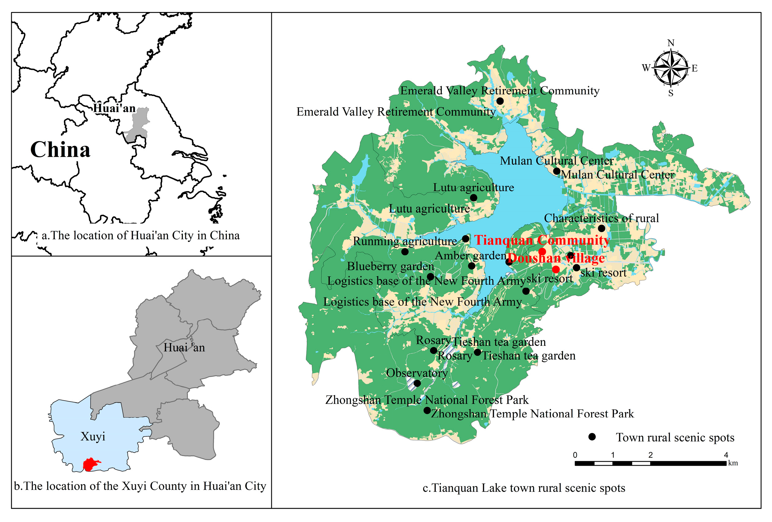
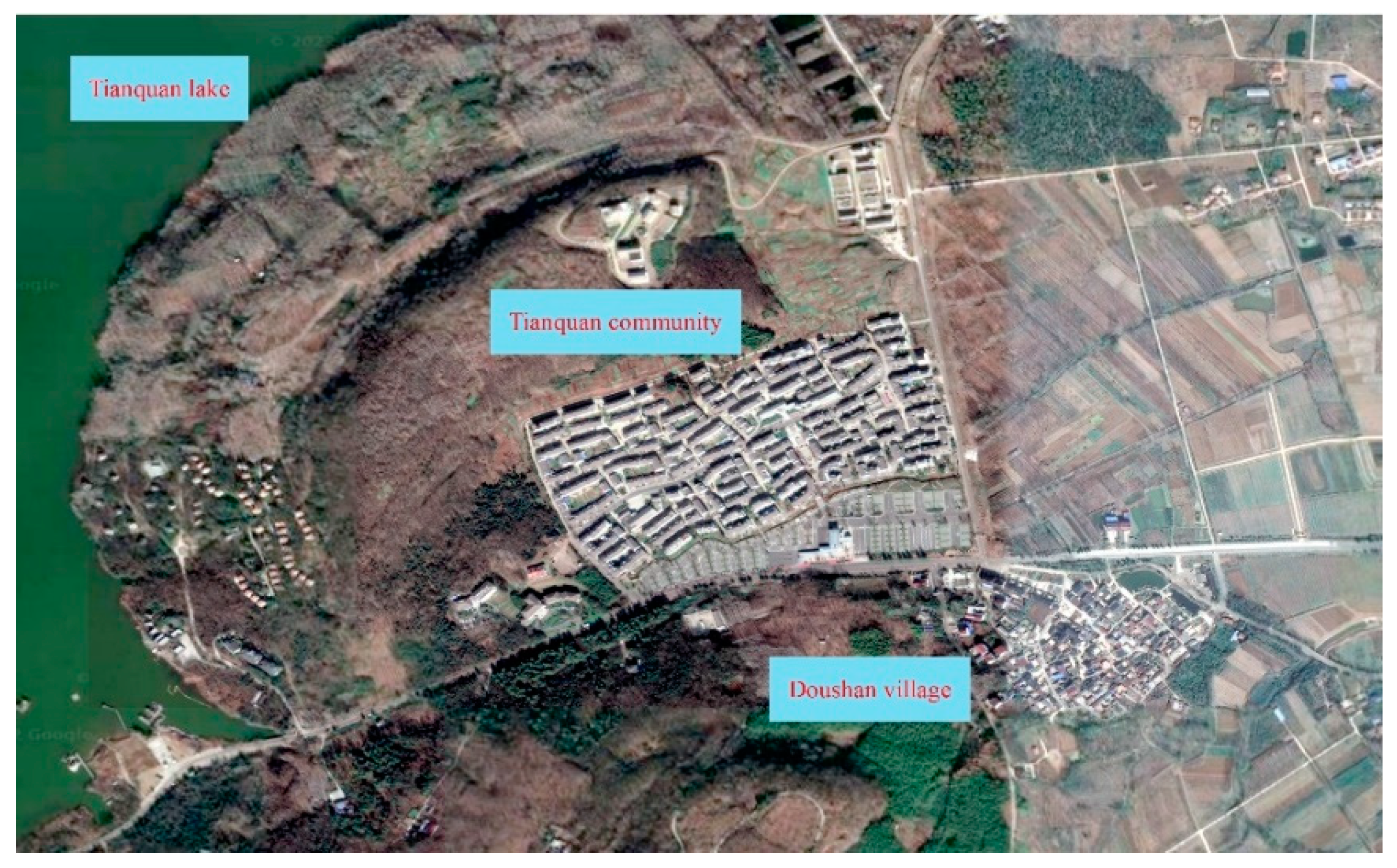
3. Research Areas
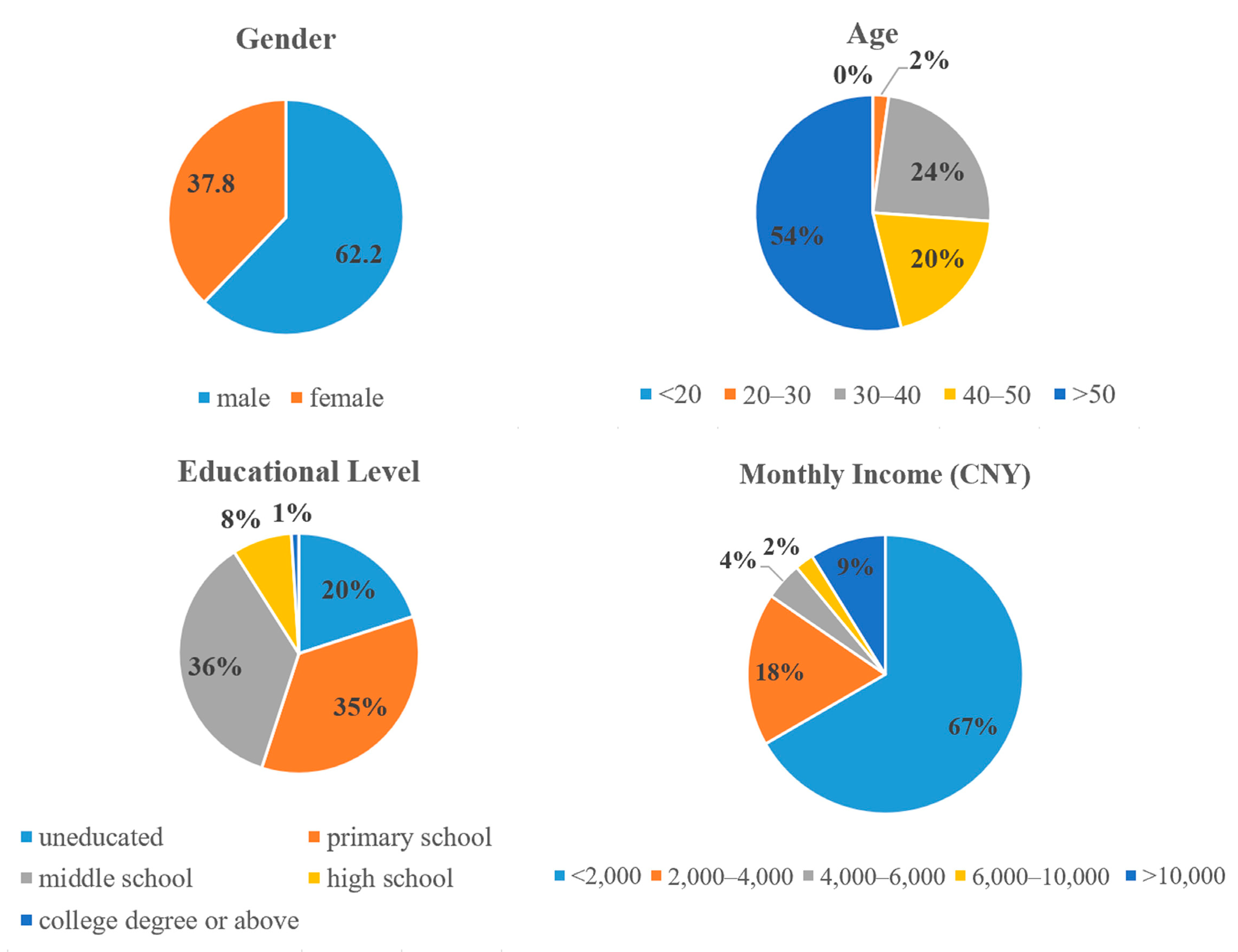
4. Research Design
5. Results and Discussion
5.1. The Multi-Dimensional Environment Evaluation System Based on AHP
5.2. The Residents’ Satisfaction of Multi-Dimensional Environments
5.3. The Affecting Mechanism of Space Reconstruction on Multi-Dimensional Environments
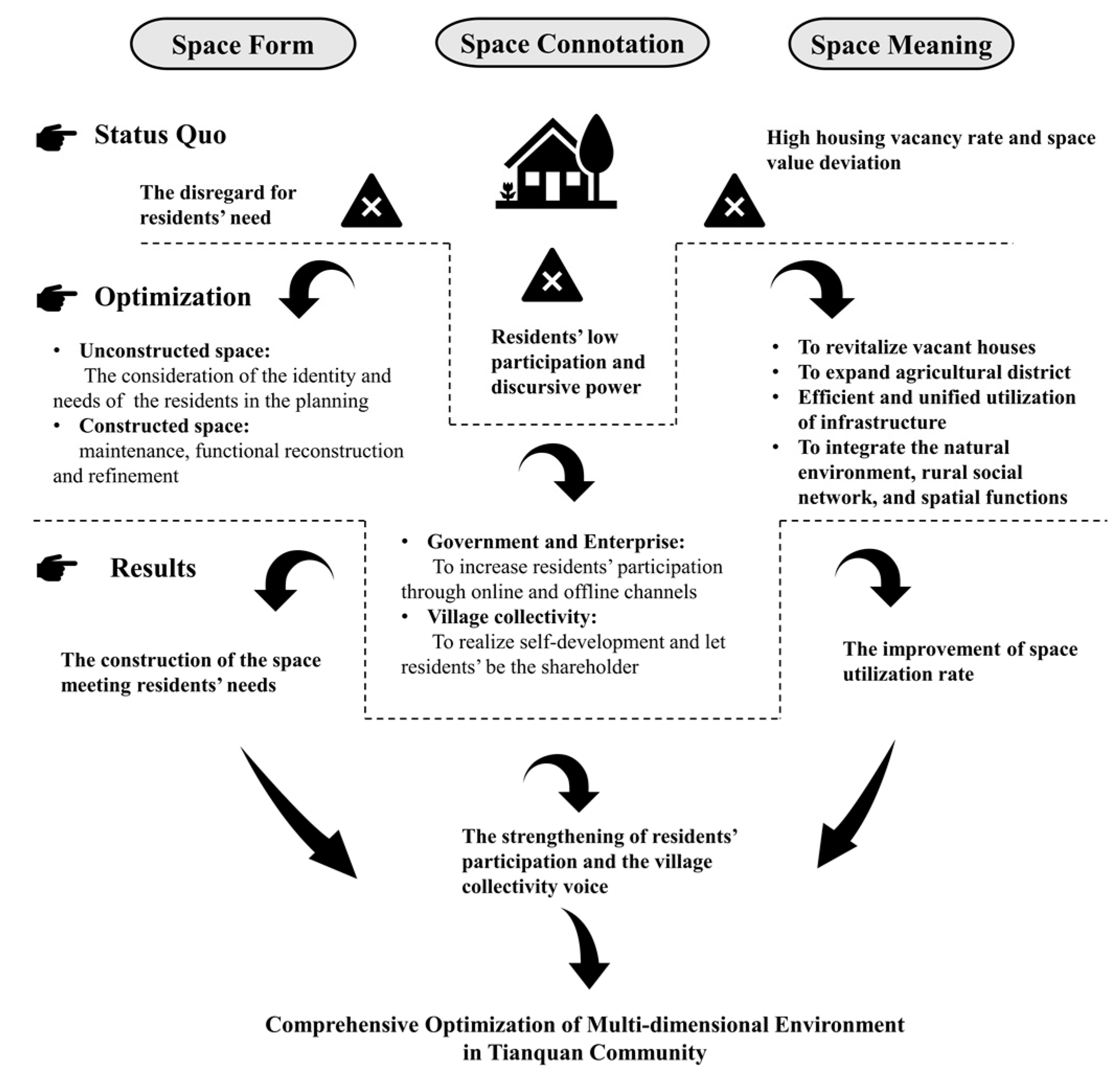
5.4. The Optimization Path of Multi-Dimensional Environments in Rural Settlements
6. Conclusions
Author Contributions
Funding
Institutional Review Board Statement
Informed Consent Statement
Data Availability Statement
Acknowledgments
Conflicts of Interest
References
- Ye, L.; Wu, Z.H.; Wang, T.; Ding, K.L.; Chen, Y. Villagers’ satisfaction evaluation system of rural human settlement construction: Empirical study of Suzhou in China’s rapid urbanization area. Int. J. Environ. Res. Public Health 2022, 19, 11472. [Google Scholar] [CrossRef] [PubMed]
- Esch, T.; Heldens, W.; Hirner, A.; Keil, M.; Marconcini, M.; Roth, A.; Zeidler, J.; Dech, S.; Strano, E. Breaking new ground in mapping human settlements from space—The global urban footprint. ISPRS J. Photogramm. Remote Sens. 2017, 134, 30–42. [Google Scholar] [CrossRef] [Green Version]
- Zhang, L.; Huang, C.; Zhao, D.; Du, H.; Lu, Q.; Yu, H.; Yu, Y.; Chen, Y.; Zhang, M. Design optimization for urban landscape from the perspective of ecological chain, anti-planning and barrier free design: The unity of natural and social environmental benefits. Fresenius Environ. Bull. 2021, 29, 9095–9102. [Google Scholar]
- Jiang, L.; Wang, L. New urbanization and rural tourism development under the rural revitalization strategy environment. J. Environ. Public Health 2022, 2022, 4095446. [Google Scholar] [CrossRef] [PubMed]
- Wang, J.; Zhou, F.; Xie, A. The impact of integrated development of agriculture and tourism on rural ecological environment quality. Wirel. Commun. Mob. Comput. 2022, 2022, 6113324. [Google Scholar] [CrossRef]
- Xie, Y.; Meng, X.; Cenci, J.; Zhang, J. Spatial pattern and formation mechanism of rural tourism resources in China: Evidence from 1470 national leisure villages. ISPRS Int. J. Geo-Inf. 2022, 11, 455. [Google Scholar] [CrossRef]
- Cao, J.; Qiu, H.; Morrison, A.; Wei, W. The role of social capital in predicting tourists’ waste sorting intentions in rural destinations: Extending the theory of planned behavior. Int. J. Environ. Res. Public Health 2022, 19, 12789. [Google Scholar] [CrossRef]
- Nie, C.; Liu, Z.; Yang, L.; Wang, L. Evaluation of spatial reconstruction and driving factors of tourism-based countryside. Land 2022, 11, 1466. [Google Scholar] [CrossRef]
- Liu, X.; Kong, M.; Tong, D.; Zeng, X.; Lai, Y. Property rights and adjustment for sustainable development during post-productivist transitions in China. Land Use Policy 2022, 122, 106379. [Google Scholar] [CrossRef]
- Su, Y.; Li, R.; Ma, H.; Huang, L. Adaptive change of institutions and dynamic governance of the tragedy of the tourism commons: Evidence from rural China. J. Hosp. Tour. Manag. 2022, 53, 32–49. [Google Scholar] [CrossRef]
- Yang, G.; Zhou, C.; Zhang, J. Does industry convergence between agriculture and related sectors alleviate rural poverty: Evidence from China. Environ. Dev. Sustain. 2022. [Google Scholar] [CrossRef]
- Zhao, D.; Guo, Y.; Wang, G.; Guan, X.; Zhou, X.; Liu, J. Fractal analysis and classification of pore structures of high-rank coal in Qinshui Basin, China. Energies 2022, 15, 6766. [Google Scholar] [CrossRef]
- Ge, D.Z.; Zhou, G.P.; Qiao, W.F.; Yang, M.Q. Land use transition and rural spatial governance: Mechanism, framework and perspectives. J. Geogr. Sci. 2020, 30, 1325–1340. [Google Scholar] [CrossRef]
- Fan, N.; Shu, Y.; Xu, Z.; Zhao, D. Research progress of acid mine wastewater treatment by bioremediation method with sulfate reducing bacteria as the core. Fresenius Environ. Bull. 2021, 30, 9561–9571. [Google Scholar]
- Cloke, P.; Goodwin, M. Conceptualizing countryside change: From post-fordism to rural structured coherence. Trans. Inst. Br. Geogr. 1992, 17, 321–336. [Google Scholar] [CrossRef]
- Cloke, P. Country backwater to virtual village? Rural studies and “the Cultural Turn”. J. Rural Stud. 1997, 13, 367–375. [Google Scholar] [CrossRef]
- Lefebvre, H. Preface: The production of space. Estud. Avançados 2013, 27, 123–132. [Google Scholar] [CrossRef] [Green Version]
- Harvey, D. The Right to the City. Int. J. Urban Reg. Res. 2003, 27, 939–941. [Google Scholar] [CrossRef]
- Castells, M. A network theory of power. Int. J. Commun. 2011, 5, 773–787. [Google Scholar]
- Soja, E.W. Beyond Postmetropolis. Urban Geogr. 2011, 32, 451–469. [Google Scholar] [CrossRef]
- Halfacree, K. Contesting rurality. politics in the British countryside. J. Rural Stud. 2008, 24, 478. [Google Scholar] [CrossRef]
- Frisvoll, S. Power in the production of spaces transformed by rural tourism. J. Rural Stud. 2012, 28, 447–457. [Google Scholar] [CrossRef] [Green Version]
- Panzer-Krause, S. The lost rural idyll? Tourists’ attitudes towards sustainability and their influence on the production of rural space at a rural tourism hotspot in Northern Ireland. J. Rural Stud. 2020, 80, 235–243. [Google Scholar] [CrossRef]
- Galani-Moutafi, V. Rural space (re)produced—Practices, performances and visions: A case study from an Aegean island. J. Rural Stud. 2013, 32, 103–113. [Google Scholar] [CrossRef]
- Zhu, Y. Research on reproduction of rural tourism culture based on spatial production theory-Take Xiangyang Wushan tea altar and Yanhe tea culture tourism as examples. Territ. Nat. Resour. Study 2018, 41, 61–65. [Google Scholar]
- Xiang, C.; Li, H.; Li, Y.; Wang, Y. Space Production Patterns and Governance Methods of rural Tourism: A Case Study of Wulong Village, Langzhong City. J. Shanxi Inst. Econ. Manag. 2021, 29, 55–61. [Google Scholar]
- Long, X.; Xu, J. Research on the spatial reconstruction mechanism of rural tourism from the perspective of spatial production-Taking 4 villages in Jiangning District, Nanjing as an example. Anhui Agric. Sci. 2022, 50, 115–118. [Google Scholar]
- Saaty, T.L. Rank from comparisons and from ratings in the analytic hierarchy/network processes. Eur. J. Oper. Res. 2006, 168, 557–570. [Google Scholar] [CrossRef]
- Saaty, T.L. How to make a decision: The analytic hierarchy process. Interfaces 1994, 24, 19–43. [Google Scholar] [CrossRef] [Green Version]
- Vaidya, O.S.; Kumar, S. Analytic hierarchy process: An overview of applications. Eur. J. Oper. Res. 2006, 169, 1–29. [Google Scholar] [CrossRef]
- Ishizaka, A.; Labib, A. Review of the main developments in the analytic hierarchy process. Expert Syst. Appl. 2011, 38, 14336–14345. [Google Scholar] [CrossRef] [Green Version]
- Forman, E.H.; Gass, S.I. The analytic hierarchy process—An exposition. Oper. Res. 2001, 49, 469–486. [Google Scholar] [CrossRef]
- Saaty, T.L. Decision-making with the AHP: Why is the principal eigenvector necessary. Eur. J. Oper. Res. 2003, 145, 85–91. [Google Scholar] [CrossRef]
- Saaty, T.L. Relative Measurement and Its Generalization in Decision Making Why Pairwise Comparisons are Central in Mathematics for the Measurement of Intangible Factors the Analytic Hierarchy/Network Process. Rev. Real Acad. Cienc. Exacats Fis. Nat. Ser. A-Mat. 2008, 102, 251–318. [Google Scholar] [CrossRef]
- Saaty, T.L.; Tran, L.T. On the invalidity of fuzzifying numerical judgments in the Analytic Hierarchy Process. Math. Comput. Model. 2007, 46, 962–975. [Google Scholar] [CrossRef]
- Saaty, T.L. The Modern Science of Multicriteria Decision Making and Its Practical Applications: The AHP/ANP Approach. Oper. Res. 2013, 61, 1101–1118. [Google Scholar] [CrossRef]
- Halfacree, K. To revitalise counterurbanisation research? Recognising an international and fuller picture. Popul. space place 2008, 14, 479–495. [Google Scholar] [CrossRef]
- Halfacree, K. Heterolocal Identities? Counter-Urbanisation, Second Homes, and Rural Consumption in the Era of Mobilities. Popul. Space Place 2012, 18, 209–224. [Google Scholar] [CrossRef]
- Halfacree, K.; Williams, F. Advancing rural as ‘something more than a human estate’: Exploring UK sheep-shaping. J. Rural Stud. 2021, 87, 375–387. [Google Scholar] [CrossRef]
- Halfacree, K. ‘A solid partner in a fluid world’ and/or ‘line of flight’? Interpreting second homes in the era of mobilities. Nor. Geogr. Tidsskr.-Nor. J. Geogr. 2011, 65, 144–153. [Google Scholar] [CrossRef]
- Folinas, S.; Obeta, M.U.; Etim, G.U.; Etukudoh, S.N. COVID-19 pandemic: The medical tourism and its attendant outcome for Nigeria. IOSR J. Bus. Manag. 2021, 23, 26–35. [Google Scholar]
- Woods, M. Precarious rural cosmopolitanism: Negotiating globalization, migration and diversity in Irish small towns. J. Rural Stud. 2018, 64, 164–176. [Google Scholar] [CrossRef]
- Folinas, S.; Metaxas, T. Tourism: The great patient of coronavirus COVID-2019. Int. J. Adv. Res. 2020, 8, 365–375. [Google Scholar] [CrossRef]
- Halfacree, K. Trial by space for a ‘radical rural’: Introducing alternative localities, representations and lives. J. Rural Stud. 2006, 23, 125–141. [Google Scholar] [CrossRef]
- Liu, W.; Henneberry, S.R.; Ni, J.; Radmehr, R.; Wei, C. Socio-cultural roots of rural settlement dispersion in Sichuan Basin: The perspective of Chinese Lineage. Land Use Policy 2019, 88, 104126. [Google Scholar] [CrossRef]
- Halfacree, K.H.; Rivera, M.J. Moving to the countryside… and staying: Lives beyond representations. Sociol. Rural. 2012, 52, 92–114. [Google Scholar] [CrossRef]
- Harvey, D. The Urbanization of Capital; Blackwell: Oxford, UK, 1985. [Google Scholar]
- Castells, M. The City and the Grassroots; University of California Press: Berkeley, CA, USA, 1986. [Google Scholar]
- Ye, C.; Ma, X.; Gao, Y.; Johnson, L. The lost countryside: Spatial production of rural culture in Tangwan Village in Shanghai. Habitat Int. 2020, 98, 102137. [Google Scholar] [CrossRef]
- Frisvoll, S. Conceptualising authentication of ruralness. Ann. Tour. Res. 2013, 43, 272–296. [Google Scholar] [CrossRef] [Green Version]
- Davey, H.M.; Barratt, A.L.; Butow, P.N.; Deeks, J.J. A one-item question with a Likert or Visual Analog Scale adequately measured current anxiety. J. Clin. Epidemiol. 2007, 60, 356–360. [Google Scholar] [CrossRef]
- Yang, J.; Luo, Y.; Chen, F. An investigation of vascular plants resources in Tieshansi National Forest Park. J. Huaiyin Teach. Coll. (Nat. Sci. Ed.) 2004, 3, 328–333. [Google Scholar]
- Halfacree, K. From dropping out to leading on? British counter-cultural back-to-the-land in a changing rurality. Prog. Hum. Geogr. 2006, 30, 309–336. [Google Scholar] [CrossRef]
- Long, H.; Qu, Y. Land Use Transitions and Land Management: A Mutual Feedback Perspective. Land Use Policy 2018, 74, 111–120. [Google Scholar] [CrossRef]
- Hong, H.; Xie, D.; Liao, H.; Tu, B.; Yang, J. Land Use Efficiency and Total Factor Productivity-Distribution Dynamic Evolution of Rural Living Space in Chongqing, China. Sustainability 2017, 9, 444. [Google Scholar] [CrossRef] [Green Version]
- Huang, Y.; Chen, L.; Li, X. Productivism and Post-Productivism: An Analysis of Functional Mixtures in Rural China. Land 2022, 11, 1490. [Google Scholar] [CrossRef]
- Coats, J.E. Residential Stability Versus Residents’ Interactions: The Determinants of Voluntary Participation in Police Block Activity. Polic.-A J. Policy Pract. 2021, 15, 1463–1475. [Google Scholar] [CrossRef]
- Niu, N.; Li, L.; Li, X.; He, J. The Structural Dimensions and Community Vibrancy: An Exploratory Analysis in Guangzhou, China. CITIES 2022, 127, 103771. [Google Scholar] [CrossRef]
- Sun, Q.; Zhang, Y.; Wang, F. Relations of Residents? Knowledge, Satisfaction, Perceived Importance and Participation in Emergency Management: A Case Study in Modern and Old Urban Communities of Ningbo, China. Int. J. Disaster Risk Reduct. 2022, 76, 102997. [Google Scholar] [CrossRef]


| Code | Factor | Description |
|---|---|---|
| B1 | Housing environment | Space, quality, structure, decoration, and utilization of the residents’ houses |
| B2 | Road environment | Traffic convenience, accessibility, and road conditions |
| B3 | Healthcare environment | Medical resources to cure diseases, health examination, and insurance of the physical and mental health of the residents. |
| B4 | Hygienic environment | Clean water, fresh air, green food, and household waste disposal system |
| B5 | Ecological environment | Conditions that influence the sustainable inter-relationship of the living organisms include plants, animals, and microbes |
| B6 | Security environment | Protection of people’s lives and property security |
| B7 | Cultural activities | Celebration of traditional festivals and heritage of rural culture |
| B8 | Inhabitation by outsiders | Immigrants who inhabit in the settlements because of work or vacation |
| B9 | Policy support | Policy from the government to support the residents’ daily lives as well as tourism businesses |
| B10 | Distribution of benefits | Benefits received on land that is under collective ownership and are distributed by village officials |
| B11 | Manage status | Government’s establishment of the rules, goals, and strategic plans, as well as the operation of it |
| B12 | Land circulation subsidy | Money that is paid by the government to the residents to acquire their agriculture and housing land |
| B13 | Working environment | Physical environment, facilities, tools, teamwork communication, and working atmosphere |
| B14 | Economic income | Wage, welfare, bonus, social insurance, paid vacation, interests, business income |
| Research Areas | Tianquan Community | Doushan Village |
|---|---|---|
| Types of rural settlements | Relocation Village | Sightseeing and Settlement Symbiosis Village |
| Population | 5195 | 5783 |
| Area (km2) | 24 | 13 |
| Composition of the residential population | Relocated residents from surrounding settlements; the elderly and children as the major population | Indigenous residents as the major population, and immigrants as a supplement; the elderly, children, and middle-aged persons |
| Main economic activities | Health and wellness tourism; elderly care service | Leisure tourism; fruit farming; agritainment |
| Forms of spatial morphological change | Unified spatial planning; relatively well-equipped facilities; open space | Maximally retaining the original body of the building; reconstruction of the External Space; mixed functions; optimization of the landscape; open space |
| Exploitation and utilization pattern | Residence as the primary function; commercial and tourism as the secondary function | Living and tourism as the primary function |
| Objective Layer Score (Z) | Criterion Layer Score (A) | Index Layer Score (B) | Rank |
|---|---|---|---|
| Residents’ Overall Satisfaction (63.73) | A1 Living Environment (76.52) | B1 Housing Environment (75.76) | 4 |
| B2 Road Environment (74.55) | 5 | ||
| B3 Healthcare Environment (73.74) | 6 | ||
| B4 Hygienic Environment (78.99) | 2 | ||
| B5 Ecological Environment (80.20) | 1 | ||
| A2 Human Environment (76.30) | B6 Security Environment (78.79) | 3 | |
| B7 Cultural Activities (70.91) | 7 | ||
| B8 Inhabited by Outsiders(68.68) | 8 | ||
| A3 Management Environment (52.56) | B9 Policy Support (61.17) | 10 | |
| B10 Distribution of Benefits (51.71) | 13 | ||
| B11 Management Status (57.17) | 12 | ||
| B12 Land Circulation Subsidy (47.07) | 14 | ||
| A4 Economic Environment (58.71) | B13 Working Environment (63.02) | 9 | |
| B14 Economic Income (57.37) | 11 |
| Objective Layer Score (Z) | Criterion Layer Score (A) | Index Layer Score (B) | Rank |
|---|---|---|---|
| Residents’ Overall Satisfaction (69.89) | A1 Living Environment (81.13) | B1 Housing Environment (80.50) | 4 |
| B2 Road Environment (79.00) | 5 | ||
| B3 Healthcare Environment (78.00) | 6 | ||
| B4 Hygienic Environment (84.50) | 1 | ||
| B5 Ecological Environment (84.00) | 2 | ||
| A2 Human Environment (80.24) | B6 Security Environment (83.50) | 3 | |
| B7 Cultural Activities (75.50) | 7 | ||
| B8 Inhabited by Outsiders (72.00) | 8 | ||
| A3 Management Environment (64.16) | B9 Policy Support (57.00) | 14 | |
| B10 Distribution of Benefits (61.50) | 13 | ||
| B11 Management Status (70.50) | 9 | ||
| B12 Land Circulation Subsidy (63.00) | 11 | ||
| A4 Economic Environment (64.17) | B13 Working Environment (69.50) | 10 | |
| B14 Economic Income (62.50) | 12 |
Publisher’s Note: MDPI stays neutral with regard to jurisdictional claims in published maps and institutional affiliations. |
© 2022 by the authors. Licensee MDPI, Basel, Switzerland. This article is an open access article distributed under the terms and conditions of the Creative Commons Attribution (CC BY) license (https://creativecommons.org/licenses/by/4.0/).
Share and Cite
Chen, Y.; Zhang, Q.; Zhao, D.; Folinas, S.; Zhang, W. Optimization Approaches of Multi-Dimensional Environments in Rural Space Reproduction Driven by Tourism. Appl. Sci. 2022, 12, 12527. https://doi.org/10.3390/app122412527
Chen Y, Zhang Q, Zhao D, Folinas S, Zhang W. Optimization Approaches of Multi-Dimensional Environments in Rural Space Reproduction Driven by Tourism. Applied Sciences. 2022; 12(24):12527. https://doi.org/10.3390/app122412527
Chicago/Turabian StyleChen, Yingxing, Qing Zhang, Difei Zhao, Sotiris Folinas, and Wei Zhang. 2022. "Optimization Approaches of Multi-Dimensional Environments in Rural Space Reproduction Driven by Tourism" Applied Sciences 12, no. 24: 12527. https://doi.org/10.3390/app122412527